279
In memoriam
J.-K.
Haalebos (t06-iii-2001)The
cohors equitata
fort at Tihau-Cetate, Romania:
the results of geophysical survey and other research
Julian Bennett
This paper considers the evidence provided by a resistivity and magnetometer survey of the Roman fort at TiM.u-Cetate, located in SlHaj province in the north of modern Romania, 1 km north-east of the village of Tihau, and 500 m south-west of the village of Surduc (figs. 1-2). The survey produced exceptional images for the internal layout of a stone-built fort, revealing for the first time the full plan of such a structure in Dacia. When considered alongside information recovered from earlier small-scale excavations, the geophysical imagery permits an assessment of the site's history and provides support for recent arguments concerning the structural arrangements to be expected in a fort built for a
cohors quingenaria equitata.
The historical context
The two Dacian Wars of Trajan culminated in AD. 106 with annexation of the territory ruled by Decebalus. That part of his kingdom represented today by Eastern Oltenia, Muntenia and Moldavia was assigned to the existing province of
Moesia Inferior,
while the remainder, mod-ern Banat and the Siebenbiirgen, was made into a new consular province ofDacia.
1 It is generally believed that at the same time, while Trajan was in the province, the decision was made to define the formal N boundary of the new province with a series of permanent auxiliary forts, among them Tihifo-Cetate and its closest neighbours,Porolissum
(Moigrad), 15 km to the west, andSamum
(Ca~eiu), 50 km to the east (fig. 1).2 It also generally accepted that the majority, if not all, of these 'conquest-period' forts were built in the 'Holz-Erde' method, with earth and timber defences and wooden internal buildings.3 Finally, it is usually assumed that the major work of creating this frontier system was completed by 110/112, since by then all the legions involved in Trajan's conquest of Dacia had been sent elsewhere, except forLegio XIII
Gemina,
now given a permanent base atApulum
(Alba Julia).The beginning of Hadrian's reign saw these arrangements changed in several ways. In 118, for example, Muntenia and Moldavia were abandoned as part of a revised treaty with the Roxolani, while Oltenia was detached from
Moesia Inferior
to become the new procuratorial province ofDacia Inferior,
the original province ofDacia
being renamedDacia Superior.
4 Then, sometime before 123, this administrative scheme too was modified, for the part ofDacia
Superior
north of the confluence of the Mure~-Arie~ (thus including the fort at Tihau-Cetate) was separated fromDacia Superior
to form yet another new procuratorial province,Dacia
Porolissensis.
5 In addition, the latter part of Hadrian's reign saw some of the 'Holz-Erde' fortsin the three Dacian provinces rebuilt in stone, notably Hoghiz, Gilau, Ili~ua, Radacine~ti,
Bivolari-Arutela,
and Copaceni, all of which have produced inscriptions testifying to the fact. The reigns of Antoninus Pius and Marcus Aurelius saw further changes to the Dacian provin-ces. In about 159, even though there was no change in the administrative structure,Dacia
Superior
was renamedDacia Apulensis,
andDacia Inferior
becameDacia Malvensis,
with only1 Gudea 1997, 6-7; for a summary of the Dacian Wars and the process of provincialisation, Bennett 2002, 85-103 and 163-72; for an introduction to Iron Age and Roman Dacia, Haynes and Hanson 2004; for a full account of Dacia and Rome in the years leading up to the end of Trajan's Dacian Wars, Stefan 2005. 2 Cf. Gudea 1997, 7; Haynes and Hanson 2004, 18 and Stefan 2005, 666-67, with fig. 276. The ancient
name of the Tihau-Cetate site is unknown, but Triphulum (Ptol., Geog. 3.8) is one possibility: cf. Bogdan Cataniciu, 2002, fig. 1.
3 Gudea 1997, 8 and 12. On the 'Holz-Erde' method of construction, cf. Johnson 1983, 56-66, esp. 61-62.
4 Cf. HA Hadr. 6.6-7 and Birley 1997, 95. s Birley 1997, 95-96.
280
J.
Bennett
-
--192...
...
242 ~ ~ ~ ~ ~ ,Jo-Drawn: B. Claasz Coockson 2006
Drawn: B. Claasz Coockson 2006
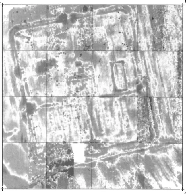
Fig. 2a (above). Tihau-Cetate in its regional topographical context (based on Gudea 1997, 51).
Fig. 2b. Tihau-Cetate in its immediate topographical context, with the area of the 1958 excavation indicated (based on Protase 1994, fig. 4, with additions from GPS readings taken on site in 2003 and 2004).
The
cohors equitata
fort at Tihau-Cetate, Romania
2s1Dacia Porolissensis
keeping its original name.6 A more momentous adjustment came between 164 and 167, when raids into NE Dacia resulted inLegio V Macedonica
being transferred fromMoesia Inferior
to a new fortress atPotaissa
(Turdu) in the extreme SW corner ofDacia
Porolissensis,
and all three Dacian regions placed under the overall authority of a consular governor ofTres Daciae.
7 The reinforced garrison evidently managed to preserve regionalsecurity until the reign of Gallienus (253-268), when
Dacia Malvensis
was lost to barbarian attack for a time (if not permanently), an event that emphasised the inherent difficulties in protecting this group of provinces protruding north of the Danube. Consequently, in 272, as Aurelian found himself increasingly faced with threats to the more defensible parts of the empire, what was left of Trajan's original conquest was formally abandoned, except for certain of the forts on the Danube's left bank.8Setting and earlier research
As with most Roman forts, that at TiM.u-Cetate satisfied a specific strategic consideration, to control travel along the course of the river Some~, and the entrance from the Some~ basin into the Alma~ valley, the natural channel for both attack and trade between
barbaricum
and the Inner Carpathian plain, the heart of Trajan'sDacia
(fig. 1). The fort was built towards the NE edge of a plateau marking a raised river gravel terrace on the left (S) bank of the Some~, some 35 m above the present valley bottom (225 m asl; fig. 2a). The location gives first-rate and un-restricted views over the Some~ basin in both directions, especially to the west and the mouth of the Alma~ valley, but also to the northeast and the Some~ gorge. Strategic considerations apart, tactical factors played a part in its exact location, notably the protection from direct assault given by the steep scarp facing the Some~ on the north (fig. 2b ). Extra tactical security was provided on the east by the steep edge of the valley containing the Briglez, while on the west the location was further strengthened by an old stream-bed, now used as an access track to the Tihau-Cetate plateau but which still fills rapidly with run-off during heavy winter (and summer) storms.The existence of a Roman site at Tihau-Cetate has been known since at least 1793, when a badly damaged inscription was found in the vicinity.9 Although its present whereabouts are
unknown and the two published transcripts leave room for argument over its precise reading, enough survives to suggest that it was a dedication set up by a group of 5 men to honour a
beneficiarius
ofLegio V Macedonica.
Dedications of this type are common in the Dacian provinces, the same unit having supplied at least 10 otherbeneficiarii
in the region.10 In this particular case, the men who commissioned the inscription included one with the rank ofprinceps,
presumably the fort's senior centurion or acting commander at the time. As nopraenomina
appear in the text, and both thisprinceps
and one other man listed on the inscription share thenomen
Aurelius, a date after 212 seems likely.The inscription having alerted antiquarians to the presence of Roman remains at Tihau-Cetate, the site featured in a number of accounts about Roman Dacia.11 However, in spite of its
relatively good state of preservation (the bank marking its defences still stands over 1 m high in places), it was effectively ignored until the mid-20th c.12 What prompted its 'rediscovery' was the disinterment of a large number of artefacts by agricultural and other invasive activities, not the least stone-robbing for constructing the railway station at nearby Surduc. Among the more notable objects recovered were two inscriptions on limestone. The first is a
6 HA Ant.P. 5.4.
7 Birley 1987, 145; Mann 1985, 220-21.
8 Eutr. 9.15.1; HA Aurel. 39.7; cf. Gazdac 2002a, 96-98, and 2002b, 738.
9 CIL III 838.
10 Cf. the list provided in Schallmayer et al. 1990, 501-68, which does not include this inscription. 11 E.g., Niegebaur 1851, 233-34 and Torma 1880, 86-89.
282
J.
Bennett
building stone, found in 1952 in the N gateway, recording work by a vexillation of
Legio XIII
Gemina.13
The second is an altar unearthed in 1954 in the fort's NE corner, dedicated by the previously unknown Claudius or Flavius Postumus,consularis (trium Daciarum),
to the'Nymphis Augg',
probably on behalf of Caracalla and Geta, and so datable to 211.14In addition to these inscriptions and other artefacts, the site had by then also produced some 20 bricks and tiles marked with one of 4 different versions of the brick-stamp C I C F: this ellipsis was eventually read as
C(ohors) I C(annane)F(atium), 15
althoughC(ohors) I
C(annanefatium) f(ecit)
seems more probable. The unit was originally raised in the Lower Rhine region from among the local Cannanefates during the 1st c. A.D., perhaps in c.28 along with its sister unit, theala Cannanefatium,
although it first enters the historical record in 68 as a part of Vitellius' army.16 The regiment is listed among the garrison ofDacia Porolissensis
on diplomas of A.D. 131, 151, 154, and 164,17 and while it may well have returned toGermani.a
Inferior
with the other Lower Rhine units in 70, its early attestation inDacia Porolissensis
suggests that it was a part of Trajan's invasion army. Indeed, it is quite probable that it was posted to Tihau-Cetate in c.106, and it could have remained therein praesidia
until c.270 for, unlike so many Dacian forts, this one has not produced any evidence in the form of tile-stamps for any other unit being present. lsContinued stone-robbing at the site inspired the firsl archaeological work in 1958, under the direction of D. Protase, 19 but it remained subject to agricultural activity and consequent damage until brought under State control in 1994, by when it had produced many other artefacts, including pieces of Roman cavalry equipment (which mostly remain in the custody of local inhabitants). Then, in 1997, in connection with the 17th
Limes
congress at nearby Zalau, C. Opreanu oversaw the cutting of a sectionmanu militare
across the fort's S defences to allow the participants to study their composition.20 One of the visitors was the lateJ.-K.
Haalebos, who noted that the site's characteristics, on a well-drained gravel plateau with a minimal depth of stratification, made it highly suitable for geophysical survey. Haalebos consequently arranged for and supervised such a survey in 1999, reporting his results in a preliminary form the same year.21 He briefly discussed these with the present writer at the 18thLimes
congress held at Amman in 2000. After Haalebos' premature death in 2001, the responsibility for all archaeological work at Tihau-Cetate was again assumed by Opreanu, who invited the writer to visit the site in 2003 and 2004 in order to evaluate and assess it with a view to a future joint excavation.220preanu's professionalobligations subsequently meant that the proposed project did not progress beyond the preparation of my evaluation and assessment, which forms the basis of the present article.The excavations and survey of 1958
Protase's work in 1958 was directed towards establishing the site's limits through ground survey and examining the context of a series of walls exposed by stone-robbing in its NW corner. The survey quickly
13 Protase 1994, 94 and AE 1994. 1484.
14 Petolescu 1977, 159-65; Protase 1994, 93-94 and AE 1977. 666 = 1978. 678.
15 Russu 1974, 221; cf. Wollmann 1974, 150-53; Wollmann and Bot 1974, 429-40; Protase 1994, fig. 12. 16 Tac., Ann. 4.73 for the ala Cannanefatium; Tac., Hist. 4.19 for the cohors Cannanefatium. Cf. also Spaul
2000, 233 and 238; Wollmann 1974, 152.
17 For the diploma of A.D. 131, Weifs 2002, 248-51; for A.D. 151, Isac 2001, 58; for AD. 154, RMD 47; and for A.D. 164, CIL XVI 185 and RMD 63, 64 and 287: for an undated fragment, cf. RMD 128.
18 Spaul (2002, 238) suggested the unit was possibly disbanded before 200, but there is no basis for this belief.
19 Protase 1994. 20 Opreanu 1998. 21 Haalebos 1999.
22 The funding for my involvement in the project, as well as computer and other equipment and facilities, was generously provided by the Department of Archaeology and History of Art, Bilkent University.
The
cohors equitata
fort at Tihau-Cetate, Romania
283identified the low bank marking the line of the defences on all 4 sides and the gaps in the bank that marked the expected gateways. Those gaps on the W and E sides were seen to be displaced towards the south, indicating that the S gateway was the fort's main entrance (porta praetoria). As such, the builders had ignored 'standard' military practice, which dictated that a fort face either towards the enemy (in this case, the north) or due east.23 The southern orientation was presumably chosen for the better access it provided, avoiding the precipitous slopes of the Some§ on the north and the Briglez on the east, although the planned or actual existence of a 'Limes-Weg' over the lower slopes of the Garbau hills could also have influenced the decision.
A series of 7 trenches (each 5 x 1 m) was then cut across the apparent centre line of the fort's defences on all 4 sides. Each located the remains of the fort's wall and allowed the overall dimensions to be established as 129 x 144 m, giving a maximum internal area of 1.85 ha, suitable for a cohors quingenaria peditata or
equitata.24 One trench (Section I) was then extended across the entire width of the fort's defences to clarify
their nature.25 Re-published here in simplified form as fig. 3a, this 21-m cut revealed that the N edge of the visible bank marked the inner edge of a classic V-shaped fossa fastigata (4.5 m wide and 2 m deep), filled with a black-brown soil containing much stone rubble. That a ditch was thought necessary on this side of the fort, only 35 m or so from the Some§ scarp, reflects a high degree of fortification 'by the book' (or a somewhat nervous planner).
The ditch fronted a berm 1.8 m wide, behind which was a rubble-filled robber trench (1.30 m wide and 1.95 m deep). It might be that the stone wall that once stood in the robber trench had been inserted into an existing rampart face, for if it had been a primary feature a wider berm might have been expected, so that its weight did not cause the ditch's inner lip to subside and the wall to collapse.26 This wall had revetted a
rampart (8 m wide and 0.9 m high) sealing the pre-fort ground surface. Formed from a compacted yellow clay-soil, stains revealed the previous existence of horizontal timberwork, as is appropriate for the rampart of a 'Holz-Erde' fortification. The rampart tail did not appear to have been revetted but apparently tapered at a gradual angle to run beneath a level spread of stones before disappearing.
Although the main objective of the 1958 campaign was to examine and record the building remains exposed in the fort's NW comer earlier that year, limited time precluded their proper investigation. However, it was established that those remains belonged to two separate structures aligned W-E, each with at least two building phases. The location and character of one group of remains suggested it was part of the
praetorium, the commanding officer's house, as was subsequently confirmed by the geophysical surveys.27 As
for the other structure, this was built over the via quintana north of the praetorium, and its second phase saw the addition or modification of at least one hypocausted room with a floor of opus signinum standing on brick pilae 65 cm high, the complex being heated by an apsidal praefurnium on the west.28 Judging from the evidence provided by several other forts in the region, this particular room and its adjuncts can be interpreted as part of a private bath-house or heated suite built behind the praetorium later in the fort's history.
The 1958 excavation recovered a variety of ceramic and other material, including a bronze horse phalera
(harness-junction) and a square-sectioned ballista bolt-head.29 None of this material came from contexts that
were securely associated with either the fort's initial construction or any of the subsequent alterations to the
praetorium. Even so, from the data revealed by Section I through the N defences, it was concluded that the fort was probably built in 'Holz-Erde' fashion soon after 106, although the possibility was allowed that the building inscription commemorating work by a vexillation of Legio XIII Gemina might indicate that the fort's defences at least were masonry-built from the start. It was also proposed that the same unit had comprised the
23 De munitionibus castrorum 56 and Vegetius 1.23; cf. the 'wrong' orientation at Buciumi: Gudea 1997, 42-43.
24 Protase 1994, 79-80 (where the area is mistakenly reported as 1.95 ha) with his fig. 3. 25 Protase 1994, 80-83 with his fig 4; the location of all the 1958 sections is given here on fig. 6.
26 Cf. Johnson 1983, 69-70, quoting the extreme case of the berm along the masonry section of Hadrian's Wall; but see ibid 55, where berm widths of 1.5-2 m. are noted as "commonly" found in both earth-and-timber and stone forts, although without clarifying whether this is true for stone forts built de novo, as opposed to earth-and-timber forts with stone defences added at a later date. There is a surprising lack of clear evidence on the subject of berm-widths belonging to stone defences built de novo: but note that the innermost berm at the Antonine South Shields fort is reconstructed as c.2.5 m (Bidwell and Speak 1994, fig. 4.18, pace 131), while at Wallsend (Hadrianic) it was "unusually wide" at c.7.01 m (Hodgson 2003, 19).
2 7 Protase 1994, 83 and 86.
28 Protase 1994, 86-87 with figs. 3 and 6-9.
SECTION 'A'
South
North
~
~--:/~--1
a o " ~ ~L
~__J
North
SECTION 'B'
South
=-_ J
0 2 3 4 5m
Drawn: B. Claasz Coockson 2006
Fig 3a (above). Section 'A': the N defences (based on Protase 1994, 4).
Fig 3b. The S defences (based on Opreanu 1998, fig. 1, and Haalebos [unpublished record, courtesy C. Opreanu]).
N
i
..__.
to (t)s
(t) M" M"The
cohors equitata
fort at Tihau-Cetate, Romania
2ss
fort's garrison until the arrival of the Cohors I Cannanefatium.30 But this is unlikely: while some
auxiliary-type forts of Severan date in N Africa were undoubtedly garrisoned by legionary vexilla,31 the epigraphic
evidence suggests that this was never the case in the European provinces.32
The excavation of 1997
The trench cut in 1997 through the S defences of the fort by soldiers of the Romanian army measured 20 x 1.5 m. A drawing of the E face was made soon after by C. Opreanu,33 and Haalebos was able to make his own
drawn records of this and two of the other faces in 1999 before the trench was backfilled.34 There are some
differences in the two drawings of the same E section, but the main stratigraphical and structural sequence is identical. The section drawing printed here as fig. 3b is essentially a simplified composite based on Opreanu, adjusted where necessary to match Haalebos' more meticulous documentation.
The 1997 trench confirmed that the visible outer edge of the bank marking the defences coincided with the inner edge of a V-shaped ditch. However, on this side the ditch utilised an existing dip in the slope, making it 2.5 m deep from modem ground-level along the inner edge, but 1 m from modem ground-level along the outer. At this point the ditch was re-cut at least once to give an overall width of 7 m, perhaps reflecting an awareness that the S side of the fort was most vulnerable to attack. The fill could be divided into 4 principal deposits, the earliest a grey clay 'primary' silt, sealed by a soil layer with much stone debris (mainly limestone pieces) intermixed with gravel and decayed mortar and fragments of tile and brick, all of which evidently derives from the demolition and/ or the robbing of the stone wall. This layer was sealed by a dense black deposit with some small pieces of stone, suggesting that standing water and associated vegetation in the ditch had been sealed when the fourth and final fill, a mixture of brown-grey sandy soils, was dumped in the ditch as part of a levelling operation.
A berm 1-m wide existed between the inner lip of the ditch and the outer edge of a robber trench (1.3 m wide, 1.9 m deep). The narrowness again suggests that the fort's stone wall was inserted into the face of an earlier rampart. At the base of the robber trench was a foundation bed (1.20 m wide, 25 cm deep) of river cobbles laid in 3 or 4 discrete layers. The fill produced lumps of lime mortar as well as fragments of sandstone and limestone and of brick and tile. The earlier rampart survived as a mound of well-rammed yellow sandy clay-soil, standing to a height of 1 m above a layer (10-20 cm thick) of humic material, the pre-fort ground surface. Spreads of a similar humic material (the remains of turf blocks) were noted at the face of and within the body of the rampart, and the rampart tail was marked by an upright stack of at least 5 layers of turf blocks (each between 5 and 10 cm high). These turf stacks allowed the rampart's original width to be determined as between 3.75 and 4.5-5 m wide.
Some 2.5 m behind the original tail of the rampart was a spread of mortar-bedded rounded pebbles that extended beyond the N edge of the trench, filling a 'cut' (20 cm deep) into the 'natural', and thought to be the fort's via sagularis. The overlying stratification at this point is not at all clear because of marked differences between the two versions of the drawings. However, it appears that a series of discontinuous soil layers (c.20 cm thick) had gradually accumulated over this cobble spread, as well as up against the rear rampart revetment, before they were cut by the foundation trench for a wall. The wall in question was represented only by a robber trench (1 m deep and 60 cm wide), but it seemed that a further series of soil layers (20 cm thick) had formed against its S face, before being sealed by a deposit (35 cm thick) of burnt clayey soil. The evidence suggests that this wall and the associated deposits to the north had once formed the S side of a 'rampart building' (this was later confirmed by the geophysical surveys) with a superstructure that incorporated mud-brick, and that the building had been destroyed by fire.
The geophysical survey of 1999
In the spring of 1999, students of the Department of Earth Sciences, University of Utrecht, working under the direction of J.-K. Haalebos and P.
J.
Orbons, conducted a geophysical survey of the fort and in itsimmedi-30 Protase 1994, 96-97 and 100.
31 E.g., Bu Njem and Gheriat el-Garbia, garrisoned by vexillations of Legio III Augusta: Mattingly 1995,
91.
32 Cf. Bishop 1999, contrasted with Maxfield 1986. 33 Opreanu 1998, 79.
34 Opreanu 1998, 82; Haalebos' original drawings are in Nijmegen, but copies were made available by C.
286
J.
Bennett
X
y
+
- - - - ~
=::-:--
-"'T
~~~
---:""":-
'IC'"::TT
- -
...
=---~=:-"'.:':":""--,"":-:'~
- ~ -
~~~
-+
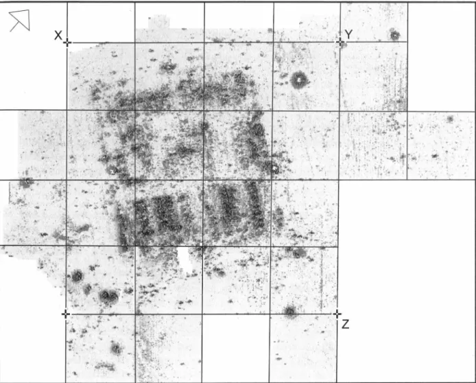
Fig. 4. The geophysical survey: the resistivity results at '50' -cm depth (image courtesy C. Opreanu: see
also Haalebos 1999, fig. 10): the white area at the south (bottom) marks the location of the 1977 trench and its spoil heap. The grid-points marked X, Y, and Z, match the same points on our figs. 5-6.
ate environs.35 Two types of instrument were used: a RM 15 resistivity meter, with two mobile and two static
electrodes, to produce subsoil plans at 'pseudo' -depths of 50 cm and 1 m; and a FM-36 fluxgate gradiometer.
As was standard practice when measuring the sub-soil imagery of a site with a known rectangular plan, the survey grid was rotated away from the fort's orientation, in this case by 15°, to avoid creating any false sub-surface images biased towards the survey grid itself. The data from the survey was converted and filtered on and off site to produce colour images of the sub-surface anomalies on a scale of 41 colour tones, reproduced here (figs. 4-5) as grey-scale images, in which the darker the shade, the higher the measured value.
The two instruments provided complementary readings - very much so, in some cases. The resistivity met-er, for example, recorded several negative features, particularly robber trenches, which were not 'found' by the magnetometer, while the magnetic survey isolated complete buildings that had not responded at all to the
35 The original records of the geophysical surveys are in the possession of P.
J
.
Orbons of ArcheoPro,Amsterdam, who will publish elsewhere a more detailed analysis of the scientific aspects of the results. I am grateful to C. Opreanu for making available copies of the geophysical survey results and a summary report, which form the basis of the commentary and illustrations published here.
.
,
·:.
' :' ;•The
cohors equitata
fort at
Tihau-Cetate, Romania
·.'
.
,.. ..,;,·...
•.,1·-;··,.
).
.
.I,
:
;-~,--. • , • ' 0 M"•..
.
•. ,:,
..
·
.,r
.
-·
,
,
. <, ..
.
,.
I ~.
-r
'•,·:
. . ,z
287...
•
:-- -111!:Fig. 5. The geophysical survey: magnetometer results (image courtesy C. Opreanu; see also Haalebos 1999, fig. 12).
resistivity meter. As is shown by a comparison between figs. 4 and 5, with few exceptions each part of the fort produced some details visible only through the electronic survey methods and others responding solely to gradiometric techniques. In other words, several areas within the fort would have produced incomplete or inaccurate data had only one survey technique been used. When combined, the two sets of data permit the reconstruction of the overall plan and layout of the stone fort (fig. 6). While caution must be exercised when
interpreting geophysical data in the absence of further excavation,36 the quality of the subsoil imagery is
sufficient to describe all of the fort's internal buildings in provisional detail, and even to draw some conclusions concerning the history of the site.
The ditches
The fort's two ditches hardly registered on the magnetometer survey, but responded very well to the resis-tivity meter, revealing that the fort was surrounded on all 4 sides by an inner ditch, augmented on the W and
E sides by an outer ditch (fig. 4; fig. 6). These ditches varied somewhat in width but are generally 4-5 m wide
and separated from each other by a berm of between 4 and 6 m. The course of the inner ditch was indicated mainly by a linear anomaly of high resistance (the product of wall rubble within its fill), but elsewhere it appeared as an anomaly of medium to low resistance. A strong anomaly indicated that this ditch was contin-uous across the line of the S gateway, but its line was interrupted opposite the three other entrances, the readings suggesting that swelling butt-end terminals existed there. The outer ditch did not respond to the
resistivity meter in such a marked way, except towards the south-east where it was made visible by a line of
high resistance. Nonetheless, the imagery showed that the outer ditch only existed on the Wand E sides.
x+
+
288J.
Bennett
~
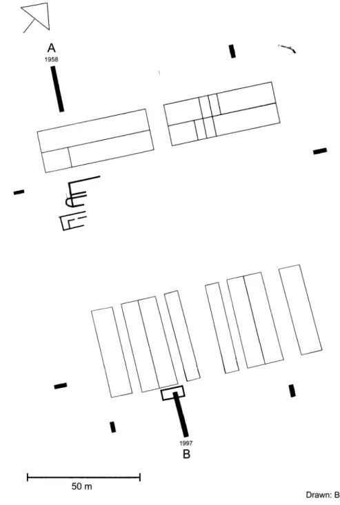
A
'
,·~ 1958\
--
I
1997B
50mDrawn: B. Claasz Coockson 2006
Fig. 6. The geophysical results interpreted.
Of special interest about the ditches is the way the continuous inner ditch opposite the S gateway and the outer ditch opposite the W and E gateways both curved outwards to form a bow shape. No exact analogy has been found among other forts where the plan of the ditches is known, except opposite the E gateway of the fort at Rainer-Buch in Baden-Wiirttemberg.37It could be that at both Tihau-Cetate and Rainer-Buch these ditches had originally ended in outwardly projecting terminals, leaving a causeway opposite the gateways,38 but that they were later joined to form a single uninterrupted feature.
The fortification wall and gateways
The line of the fort's stone wall was likewise detected only by the resistivity meter, which recorded a linear anomaly of high to very high resistance, registering in situ stonework from the wall footings and/or rubble within its robber trench. In several places, the signal merged with that marking the rubble-filled inner ditch, confirming the excavated evidence which indicated that a very narrow berm had existed between fort
37 Osten-Woldenburg 1993, 32.
38 E.g., South Shields: Bidwell and Speak 1994, 127-32.
+Y
The
cohors equitata
fort at Tihau-Cetate, Romania
289wall and the inner ditch. Elsewhere, however, the wall's alignment was frequently indicated by a distinct line (1 m wide) of high resistance, making it possible to determine that the fort was slightly narrower at the N end (125 m) than at the S (127 m) but had a constant length of 144 m, giving an overall area of 1.82 ha.
The resistivity meter also recorded well-defined signals from angle towers in the NW, SW and SE corners; and from intermediate towers in the retentura, about halfway between the portae principales and the fort's N wall. According to the data, each tower had an external measurement of c.6 x 6 m, a figure that corresponds closely with the measured width of the rampart as observed in the 1997 trench. The imagery clearly showed that the entrances to the interval tower on the W side and the angle tower in the SW corner were at the right (N) end of their rear walls.
The resistivity survey also established in an unambiguous fashion the positions of the 4 gateways, more or less where the 1958 survey had placed them, and supplied details regarding their individual characteris-tics. For example, the porta praetoria on the S side, which gave the best response, and the two portae prin-cipales were all evidently provided with two towers, each c.6 m square externally, on either side of an entrance-passage c.9 m wide, the width indicating that these gateways were of the normal double-portal type. The readings provided at the porta decumana, on the other hand, showed that, while it too was flanked by two towers, it had a single passageway, c.4 m wide, as was usual for such 'rear gateways'. The shape and strength of the resistivity readings here gave the impression that these gateway towers originally projected in front of the fort's wall, and were possibly rounded externally.39 If so, this would have been a chronological marker of great importance, as gate towers of this type can be securely dated to the Severan period and later.40 However, not only did this particular gateway produce the building stone of Legio XIII Gemina,
which must date to before 161 /167 when Tihau-Cetate came under Legio V Macedonica at Potaissa, but closer analysis of the imagery suggests it was caused by the spread of rubble from the collapse of the gate-towers and did not represent authentic architectural features.41
The street network
The two principal streets within the fort, the N-S via praetoria and the W-E via principalis, did not register on the magnetometer, but appeared as strong anomalies on the resistivity surveys. They suggested, however, that the bulk of the metalling at the T-shaped junction between the two is missing, presumably destroyed through cultivation. Yet the exceptionally strong readings marking their respective centres, especially as they approached each of the three relevant gateways, gave the impression that they were built with a significant camber. This was particularly true of the first 40 m of the via principalis immediately west of the porta principalis sinistra, presumably because that stretch carried a high level of traffic to and from the
horreum. The via decumana, on the other hand, between the porta decumana and the rear of the principia,
evidently was barely metalled at all and certainly not cambered. This was als.o the case with the via sagularis, the paved way running along the base of the fort's rampart since, with a very few exceptions, it registered only as a slight and sporadic anomaly of medium resistance to the resistivity meter. Similarly, while there are indications of some lightly metalled surfaces in other parts of the fort, especially between the parallel buildings in the praetentura, there was no evidence that any of these open spaces had been provided with a hard surface of any substance.
From the street network there is evidence that the mensor responsible for surveying the site prior to the fort's construction had difficulty in achieving true right-angles with his groma.42 The via principalis is not at
right-angles to the fort's Wand E walls, nor is the via praetoria perpendicular to the via principalis. This in tum means that the centre of the porta praetoria lies 3 m west of its geometrically correct position, and that the centre of the porta principalis sinistra in the E wall is displaced to the south of its correct point by c.5 m. Another effect of the surveyor's error is the variety of alignments followed by various buildings located in the central and S part of the fort. While the buildings in the praetentura run parallel to the via praetoria, the
principia and the horreum in the latera praetorii are aligned on the via principalis, but the praetorium was built to conform to the orientation of the fort's W defences. True, the differences in alignment are slight, and are probably more obvious from the scale-plan reproduced here than on the ground, yet the overall effect cannot be ignored. For example, the N end of the easternmost structure in the praetentura sinistra is virtually
39 Haalebos 1999, 204-5.
40 Johnson 1983, 92-93.
41 The same explanation applies to what Haalebos believed to be deliberate gateway blockings behind this
gate and the porta principalis dextra: Haalebos 1999, 205.
42 For similar irregularities in planning, cf. Ra~nov (Gudea 1997, 65-66), and Camplung Muscel (ibid. 79-80).
290
J.
Bennett
contiguous with the S edge of the via principalis, but the N end of the westernmost structure in the praetent11ra dextra is set back by c.4 m. Similarly, the SW corner of the praetori11m is set back by 2 m from the via principalis, but its SE corner is 5 m distant from that thoroughfare.
The latera praetorii: principia, praetorium and horrea
The geophysical surveys provided evidence for all three of the buildings normally found in the latera praetorii or central range: the principia, the executive focus; the praetori11m, the house of the commanding officer and his family; and the horre11m, a dry-goods store. Of these three, the principia appeared as a well-defined feature on both the resistivity and the magnetometer surveys. The praetori11m and the horre11m, on the other hand, offered very different and contrasting results to the two methods: the praetori11m, for example, barely responded to the electrical survey but produced remarkable magnetic imagery, while the horre11nz gave a superb resistivity reading but hardly registered magnetometrically.
The imagery recorded for the principia indicated that it measures c.30 x 34 m, which makes it quite a large example of this type of structure,43 occupying c.5.5% of the intervall11m area, rather than the more usual 3-4%.
Otherwise, it conforms to the standard plan, with an enclosed courtyard at the front, a central cross-hall, and a rear range of offices. In this particular case, the courtyard (13 x 15 m) is flanked on the W and E sides by linear anomalies that define internal spaces c.6 m wide, although it cannot be determined if they represent standing walls enclosing flanking halls or armamentaria, or if they are 'sleeper' footings for colonnaded ambulatories.44 To the rear of the courtyard is a cross-hall or basilica (7.5 m wide), the resistivity results indicating that its front wall was built on a more massive scale, an attribute noted at many other forts. In such cases, it is believed to indicate that the superstructure was pierced by a series of 3 or 5 wide openings at ground-level, with a row of windows above, thereby requiring a broader and deeper foundation than did the back wall which could be built to a 'standard' thickness.45
Behind the cross-hall is an enclosed space (c.5 m wide) representing the usual range of small offices found at the rear of a principia. There were 5 such rooms in most auxiliary forts, but the exact number present here cannot be determined from the geophysical evidence alone. On the other hand, this evidence clearly shows that the central room (aedes or sacell11m) projected by c.4 m beyond the rear of the principia, and the strong positive anomaly recorded here on the resistivity surveys suggests that it contained a cellar or sunken strongroom, a common feature in this location at many forts. An equally strong anomaly recorded within the rear range proper, immediately to the south-east of this putative strongroom, is best explained as marking an earlier version of the same kind of feature, in which case the projecting aedes and its strongroom are likely to have been additions.
The remains of the praetorium, especially its walls, gave an excellent magnetometric response, but the structure as a whole hardly registered on the resistivity survey, except for an area of low resistance marking its enclosed courtyard. The reason for this discrepancy in results between the techniques cannot be resolved without excavation, although they might suggest that the building had relatively insubstantial footings. This seems rather implausible, however, as the 1958 excavations here demonstrated that the N range of the
praetori11m had walls with a depth of 75 cm below the present surface. The geophysicists responsible for the
1999 survey offered three possible explanations for the remarkably high magnetometer response to this same structure. The first was that its footings were principally of a volcanic stone that could be the local conglomerate which apparently includes pebbles of haematite and other magnetised material. Secondly, these elevated readings might result from fired brick and/or tile being used for the foundations (but there is no parallel in any other fort in the European provinces). Thirdly, the geophysicists might have registered high levels of magnetism formed by bacteria during the decay process of timber walls that had rotted in sit11. These possibilities apart, it may be that the building was of the half-timbered clay-infill type common in this part of Dacia,46 and was destroyed in a fire with temperatures of over 500°, thereby magnetising the clay used in this
infill. The issue can be resolved only with the spade.
The magnetometric survey showed that the praetori11m was a rectangular structure (c.25
x
29 m) with ranges (5-6 m wide) on all 4 sides of a central courtyard, the plan and size conforming to other fort sites. A part of its N range examined in 1958 showed that that section had been rebuilt on at least one occasion. That excavation had also located a heated structure to the north of the praetori11m and occupying part of the via q11intana, and best interpreted as a private bath-house built at a later date. This building was responsible for43 Johnson 1983, 105. 44 Ibid. 106.
45 Ibid. 110. 46 Isac 2003, 21.
The
cohors equitata
fort at Tihau-Cetate, Romania
291the strong anomaly registered by both the magnetometer and the resistivity meter, marking a highly magnetic and substantial rubble-filled sub-surface feature, evidently the hypocaust found in 1958.
Some 20 m east of the principia is the horreum, an exceptionally well-defined feature on the resistivity
survey but barely visible in geomagnetic terms. The resistivity image shows a building of c.33 x 15 m exter-nally (28 x 12 m interexter-nally), with an internal floor area of c.336 m2, somewhat larger than normal for horrea
in cohortes q11ingenaria forts in Europe.47 The strong responses recorded by the resistivity meter also revealed
that the walls of this structure were much broader and more deeply-founded than those of any other internal buildings at Tihau-Cetate. As the walls of all horrea were pierced by ventilation openings to allow adequate
air flow within, they needed to be robust enough to allow for the openings and to withstand the enormous lateral stress from goods stored within. For this reason, most horrea also had buttresses along at least their
longitudinal walls, and three can be identified along the E wall of our example. Yet while the floors of all
horrea were suspended on either individual piers or on longitudinal sleeper walls, to encourage an
under-floor draught and maintain a low internal temperature, there is no evidence to indicate which method was used here. Nor can the position of the indispensable loading platform(s) be identified, although it is reasonable to assume that supplies were taken in at the Send (which is only c.l m from the edge of the via principalis) and either distributed from here or, more probably, from the large open space found at the N end.
Attention must be drawn here to the suggestion by Haalebos that the open unmetalled space existing between the horre11m and the principia was deliberately left open for a planned second horre11m.48 This is possible but unlikely, for not only would it have severely restricted traffic between the two halves of the fort, but precise methods of calculation show that the size of a horre11m like this was sufficient to hold the basic food
requirements for the type of garrison it was designed for: a q11ingenary unit.49 The praetentura
The sub-surface remains in the praetentura, the 'front' part of the fort, gave quite contrasting responses to
the magnetic and the electronic surveys. For example, while the resistivity survey recorded only intermittent ghost-like images of a low value for the wall foundations of the structures, the magnetometric survey pro-duced much stronger results that almost revealed complete plans. A range of reasons can again be offered to explain the discrepancies in the quality of the geophysical images, but that aside, both sets of readings conclusively showed that there were 4 parallel and identical buildings on either side of the via praetoria, all
arranged lengthwise (per strigas) to the fort's main axis. In each case, the building closest to the via praetoria
is a long, rather narrow structure (c.40 x 6.5 m), set back by c.2-4 m from the street frontage. The next building, separated from the first by a lightly paved area c.4 m wide, is also 40 m long but much wider (16 m), although a longitudinal anomaly reveals it is actually a back-to-back structure with a common party wall, while weaker lateral anomalies reveal that both ranges were divided into rooms of a regular size. Another lightly metalled space (4 m wide in the W part of the praetent11ra, but 6 m wide in the E part) separated these double
blocks from the fourth building in each group, which is exactly the same size (40 x 8 m) as one of the ranges in the paired blocks, and which likewise have the same kind of lateral room-dividers.
The size and layout of these sets of buildings conforms to what is found in the praetenturae of many forts
of Flavian-Hadrianic date, and there can be no doubt about their identification. Thus the buildings flanking the via praetoria can be recognised as stores buildings or workshops, while the three behind them represent
barrack-blocks divided into contubernia (individual rooms for the garrison's accommodation). With regard to
the first block in each set of buildings, such an interpretation rests not just on analogy, but also on the lack of evidence that they were ever systematically divided into a series of contubernia. Their interiors also gave
relatively weak magnetic signals, which might perhaps be explained through the lack of any substantial organically-derived deposits within them (and thus supporting the notion they were not used for domestic purposes50). The high magnetic signals from the interiors of the other buildings here point to the opposite state ::>f affairs, that they were indeed domestic buildings, as is in any case clear from the way they are divided into
;1. series of separate rooms or contubernia. Each contubernium was evidently c.3 m wide, although there was
11othing to show how much space was allocated to the outer storage room (arma) and how much to the inner
room (papilio) where the men lived. Nonetheless, the width of the contubernia would allow for the 9 such units
17 Johnson 1983, 144; cf. Richardson 2004, Table 2. 18 Haalebos 1999, 206.
19 Richardson 2004, passim.
;o Note, however, that Haalebos (1999, 207) was quite undecided as to whether the first building in each case was a barrack or a store building.
292
J.
Bennett
often found in an infantry century's barrack-block, while leaving a maximum space of c.12 x 8 m for the required centurion's quarters at the Send.
The retentura
The resistivity meter recorded virtually no clearly artificial anomalies within the retentura, the rear part of the fort, indicating that any structures here could not have foundations deeper than c.50 cm. The gradiometer, on the other hand, registered structures on either side of the via decumana broadly comparable in pattern and strength to those in the praetentura, showing that this space had been occupied by two back-to-back buildings arranged at right-angles to the fort's main axis. Both were c.46 m long with an overall width of 18 m, but they may have been separated by a narrow 'alley' rather than sharing a party wall, and variations in the magnetic signal suggest that the N parts of these blocks may have been constructed in a different way from those to the south. The geomagnetic imagery from three of the buildings showed the lateral cross-walls defining individual contubernia with a width of c.4 m, which confirms that they are barrack-blocks. In order to leave sufficient space at their interval/um ends for the required officer's house, each building probably originally contained 9 contubernia, to permit an officer's unit c.11-12 min length.
Other intra-mural structures
Aside from the heated structure located·behind the praetorium, the only other non-standard intra-mural building firmly identified was the 'rampart building' (mentioned above in connection with the 1997 section through the S defences). The resistivity survey confirmed that the wall located in 1997 represented the S side of a W-E structure measuring at least 10 m long by c.4 m wide. Its size and its location, blocking the via sagularis at the end of a barrack-block, indicates it belongs to a class of intra-mural structure present at some other forts in Dacia,51 all usually referred to as 'rampart buildings' although (as is the case here) not all are embedded within the rampart proper. Haalebos thought that discrete areas of high resistance located at other points within the fort indicated the sites of three more buildings of the same type, one each immediately north of both portae principales, and one east of the porta praetoria.52 However, a re-analysis suggests that all three
anomalies more probably represent heavily-metalled lengths of the via sagularis, rather than actual buildings. Neither the date nor the function and purpose of any of the recorded 'rampart buildings' has ever been established, although Haalebos tentatively suggested that the example(s) located at Tihau-Cetate could represent the base(s) of ballistaria for supporting heavy stone- or arrow-throwing artillery53 - defensive arrangements generally thought to be characteristic of the late 2nd or 3rd c. This seems unlikely, as the only archaeologically-proven ballistarium, at High Rochester (UK), was a masonry-encased structure of rubble and clay, built thus to absorb the recoil of stone-throwing artillery,54 and a quite different kind of structure from all the excavated 'rampart buildings' in Dacia, which were evidently roofed buildings containing a 'hollow' interior. They are more likely, therefore, to have been store-sheds or covered cooking areas.
Extra-mural structures
While the labour-intensive resistivity survey was limited to the area within and directly outside the fort's defences, the magnetometer survey covered the entire plateau at Tihau-Cetate. The hope was that evidence would be identified for the existence of a vicus adjacent to the fort, since such settlements are frequently found in close association with the forts of Dacia,55 and in some cases may have even served as centres of rural administration.56 In the event, few traces were found to indicate any such settlement here, and only one anomaly suggesting a building of some significance was recorded, outside the W outer ditch and south of any roadway leading to the porta principalis dextra. The signal could be interpreted as two walls forming the corner of a masonry structure; Haalebos thought it might indicate the remains of the fort's bath-house,57but this seems unlikely for two reasons. First, the magnetometer did not register any associated signal of the kind representing the heavy burning and remnant magnetism found with a building of this type. Second, a bath-house requires a copious and continuous supply of water, and a location on the Tihau-Cetate plateau (35 m above the Some§) would have caused great difficulties in providing this indispensable
51 Bologa-Resculum (Gudea 1997, 42); Buciumi (ibid. 43); and Moigrad-Pomet (ibid. 47). 52 Haalebos 1999, 205.
53 Ibid.
54 Johnson 1983, 94.
55 Cf. Oltean and Hanson 2001; Oltean 2004, 153-61.
56 Such was certainly the case at Ca§eiu-Samum, the centre of the statio manned by beneficiarii responsible for supervising the enigmatic regio Ans ... : cf. Isac 2003, 48-58.
The
cohors equitata
fort at Tihau-Cetate, Romania
293commodity. Assuming an extra-mural bath-house did exist at this fort, it would more probably have stood at the bottom edge of the plateau, at a level c.5 m above the Some~, where the remains of an "ancient building" were apparently destroyed during gravel quarrying in fairly recent times.58
The only other anomalies on the plateau that suggest structural remains of any significance were a group of 5 high positive values recorded directly outside the line of the outer ditch on the SW side of the fort, and a similar reading situated c.50 m due south of the fort's SE corner. The very strong values and the circular shapes of all of these suggested they were the remains of ovens, perhaps pottery kilns, an idea that found support through test-boring of the SW group that produced burnt orange soil and clay. These kilns or ovens apart, most of the other anomalies registered by the magnetometer in the extra-mural area probably represent the locations of individual sub-surface artefacts, although some of those recorded west of the fort were examined by limited trial trenching, revealing post-holes, lengths of ditches, and rubbish pits, all associated with Roman material. Of interest in the light of the possible pottery kilns recorded south and south-west of the fort, among this material were two fragments from different moulds for making the local terra sigillata; both pieces used impressed patterns of a style that matched the products of the Micasasa kilns,59 and their
presence suggests that the garrison at Tihau-Cetate was supplied with locally-made pottery.
Discussion
The fort and its history
Some problems remain concerning the precise elucidation of the 1958 and 1997 excavations, notably in correlating the results sought and obtained by two quite different methods of excava-tion, but there can be little doubt over the basic stratigraphical and chronological sequence. The fort began life as an earth-and-timber edifice of the 'Holz-Erde' type well known from the primary phases at a number of Dacian military sites. The archaeological evidence was provided by the traces of a timber-laced rampart identified in Section I of 1958 and by the turf-revetting at the front and rear of the rampart observed in the 1997 trench. In addition, a primary 'Holz-Erde' rampart is also suggested by the narrow berm found between the fort's stone wall and the inner ditch, as was confirmed by the geophysical surveys; this is best explained by the wall having been inserted into the face of an existing rampart.
Exactly when the fort's rampart was re-faced in stone is uncertain. However, the building inscription of
Legio XIII Gemina
found in the N gateway in 1952 indicates that the work is most likely to have happened while the area was still under the jurisdiction of that legion, and so probably before 123, whenDacia Superior
was divided and Tihau-Cetate became part ofDacia
Porolissensis. If
it happened later, it cannot have been after 164/167, when Tihau-Cetate and the rest ofPorolissensis
came under the aegis ofLegio V Macedonia.
A Hadrianic date is more probable than an Antonine one because the evidence indicates there was widespread rebuilding in stone in Dacia under Hadrian. The fort at Hoghiz inDacia Inferior,
for example, was rebuilt at this time by the sameLegio XIII Gemina,
60 although it seems that more usually the fort's garrison did the required work.61 Thus, theala I Siliana
rebuilt Gilau at some point between 127 and 138, while theala I Tungrorum Frontoniana
rebuilt Ili~ua in 131.62 Likewise, while one part of thenumerus Syrorum Sagittariorum
rebuilt its fortlet at Radacine~ti in 128 or later,63 another part rebuilt the neighbouring fortlet of Bivolari-Arutela in 137.64 Early in 138, thes s C. Opreanu, pers. comm.
59 Mitrofan 1991.
60 CIL III 953 = IDR 3.4.230.
61 Contrary to the generally accepted opinion, inscriptions reveal that some auxiliary units were rebuilding their forts in stone substantially before the Antonine period, as in Cappadocia in the Flavian period (Bennett 2002, 304) and at Drobeta in Dacia under Trajan (AE 1959. 309).
62 Gilau: Isac 1979 and 1997, 18, with pl. 3.1; Ili~ua: Protase 1985, 249-53 (note that this inscription is wrongly assigned to Tihau-Cetate in AE 1987. 839, and by Spaul 2000, 121).
63 CIL III 13793, recording Hadrian as Pater Patriae, a title he formally took in 128, although it does
appear on some inscriptions before that date: cf. Bennett 1984.
294
J.
Bennett
fortlet at Coplkeni was rebuilt by the
numerus burgariorum et veredariorum Daciae Inferioris.
65 It seems reasonable to conclude that the re-building of the defences in stone at Tihau-Cetate (and perhaps other forts in Dacia) is more likely to have been a project of Hadrianic date than later.Whether this rebuilding programme also extended to any of the internal buildings is not certain, and perhaps even unlikely. Such might be surmised from the work at one of Tihau-Cetate's two neighbours, the fort at
Ca.~eiu-Samum,
the most recently excavated site of its type in the region. Here the meticulous work of D. Isac has revealed the wide variations in con-structional forms that can simultaneously exist in the same fort.66 For example, although the site began life as a 'Holz-Erde' installation, with timber and earth defences and almost all of its internal buildings made of wood, theprincipia
was quite probably masonry-built from the first. When thepraetorium
was initially rebuilt because of wear-and-tear or a change in the garrison, this was done in the half-timbered method, using an adobe infill; it was not until the late 2nd c. that it was reconstructed in stone. On the other hand, whilehorreum
1 atCa.~eiu-Samum
also experienced a second half-timbered phase before being rebuilt in stone, when the time came forhorreum
2 to be reconstructed this was done using masonry. By contrast, the original 'Holz-Erde' defences apparently remained in use until the early 3rd c., when they were finally replaced in stone, but the fort's barracks remained of wood throughout the history of the site (timber alone in the primary phase, later rebuilt in half-timbered work with adobe67).Without further excavation, little can be said concerning the possible sequence and dating of the building activity inside the fort at Tihau-Cetate, not to mention the history of the site before or after the Trajanic-Hadrianic period. Nevertheless, the limited excavation that has taken place, along with the data provided by the geophysical surveys, allows some preliminary conclusions to be developed. For example, the projecting
aedes
at the rear of theprincipia
is an indication that it experienced some reconstruction work, most probably in the mid-Antonine period or later, which is when structures of this type begin to appear.68 On the other hand, while there is nothing to suggest a date for either of the two main building phases recorded for thepraetorium,
the primary phase of the heated suite built behind it and over thevia quintana
can reasonably be assigned to the early 3rd c. That can be surmised from the evidence from several other forts in Dacia: it was generally about then that parts of their internal streets began to be closed in order to extend theirpraetorii
and supply those with hypocausts. 69 A similar date has been attributed to the 'rampart buildings' at other Dacian sites and might by extension be applied to that found at Tihau-Cetate, although this chronology is based more on informed guesswork than on actual proof. Finally, we note the putative evidence for a conflagration within this building at Tihau-Cetate (and possibly the cause for the high magnetometric readings from several of the other buildings). The site perhaps was destroyed by fire, but the date and context would remain unknown.The garrison
The major significance of the geophysical surveys is their positive contribution to the debate over the relationship between the size and layout of permanent auxiliary forts and the type of unit they were originally built for. This is a contentious matter: the literary evidence attests to formulae used by Roman surveyors for calculating the size and area of temporary
65 CIL III 13795, naming Hadrian with Antoninus Pius. Cf. Hyg., Mun. cast. 24 and 30, for a unit of Pan-nonian veredarii, apparently lightly-armed and fast-moving cavalry.
66 Isac 2003.
67 Cf. Isac 2003, 120 (principia); 135-36 (praetorium); 118-20 (defences); 151, 153 and 156 (horreum l); 167 and 170 (horreum 2); and 178 (barracks).
68 Cf. Johnson 1983, 131, with Bidwell and Speak 1994, 19-20 and 74-75. 69 Isac 2003, 144-45.
The
cohors equitata
fort at Tihau-Cetate, Romania
295camps,70 and logic demands some such formulae were used when planning and building perma-nent forts, but no agreement has been reached on the parameters that might be involved. Part of the problem has been that the areas of many individual auxiliary forts can be verified, but it is not always known what type of unit they were first designed to contain. Added to this is the problem of resolving how the same fort might be occupied by a series of garrisons of an entirely different type and size but without any apparent enlargement or reduction in the area or clear changes in the internal arrangements.71
A seminal paper published over 50 years ago by I. A. Richmond endeavoured, with some success, to clarify the linear relationship between the unit's type and size and the size of indi-vidual forts.72 His analysis provided the starting point for a second (1986) which made full use of the greater amount of newly excavated data. As a result, Richmond's conclusions were vali-dated on a more systematic basis, and broad size ranges were identified for individual auxiliary units; it was also shown that the rules applying to the relationship between fort size and unit type probably varied from province to province.73 Recently, however, a more exacting mathematical approach demonstrated not only that there is a clear correlation between unit size and fort area, but that this is especially true with regard to the
intervallum
area of any one fort. 74 According to this model when reduced to its essentials, a fort such as Tihau-Cetate, with anintervallum
area of c. l.23 ha., would be appropriate for acohors quingenaria,
eitherpeditata
orequitata:
in other words, the new approach provides results that neatly parallel those arrived at in the 1986 study.75On the other hand, as Richmond himself recognised, a more reliable approach to the problem was through the evidence of a fort's internal layout. It had long been recognised that the number of barrack-blocks found within an auxiliary fort should have a direct relationship with the size and type of unit garrisoned there. Over 60 years ago, Richmond had developed a concept to express this relationship, although it applied only to the permanent forts estab-lished in the early 2nd c.76 According to this, as the c.80 men in an infantry century were housed in a single barrack-block, at 8 men per
contubernium,
then the c.60 cavalrymen found in 2turmae
of a part-mounted or a cavalry unit could likewise be housed in a single barrack-block, with 6men per
contubernium.
With slight changes to take into account later discoveries and theories, his basic analysis has stood the test of time. Hence a series of canonical rules specifying that a fort built for acohors quingenaria peditata,
for example, would have 6 barrack-blocks for its 6centuries, while one designed for a
cohors quingenaria equitata
would have 8 in all (6 for its infantry complement, and 2 for the 4 cavalry squadrons).77While Richmond's deceptively simple explanation found widespread acceptance, both it and later reviews of the issue tended to gloss over the precise nature and type of accommodation space(s) required by cavalry and part-mounted units, and over clear contradictions between the literary and the archaeological evidence and even within the archaeological evidence itself. These matters have been expertly assessed elsewhere by N. Hodgson as the result of his pains-taking excavations at the forts of Wallsend and South Shields in N England.78 One conclusion
70 Cf. Polyb. 6.32 and 41 and Vegetius 3.8; cf., however, Mun. cast. 45, where the author claimed that no
such formulae existed (an assertion probably made to enhance his own reputation as a scholar).
71 Cf. Inlaceni (Gudea 1997, 59-60), at 2.04 ha, garrisoned by three cohortes in succession: the VIII Raetorum milliaria c.R., with c.800 infantrymen, and then (the order is unclear) the I Alpinorum, with
c.480 infantrymen, and the IIII Hispanorum equitata, with c.480 infantrymen plus c.120 cavalrymen and
c.130-150 horses.
72 Richmond 1955, 304-6; see also Collingwood and Richmond 1969, 25-57.
73 Bennett 1986. 7 4 Richardson 2002.
75 Richardson 2002, 100-1; cf. Bennett 1986, 711. 7 6 Simpson and Richmond 1941.
77 Cf. Breeze and Dobson 1969; iid. 1974, 17-18; also Hassall 1983, 98, and Johnson 1983, 294-95. 7 s Hodgson 2003, 71-90; cf. Hodgson 2002.
N