ICONARP
ICONARP International Journal of Architecture & Planning Received 07 Nov 2018; Accepted 04 Dec 2018 Volume 6, Issue 2, pp: 274- 303/Published 28 December 2018 DOI: 10.15320/ICONARP.2018.55–E-ISSN: 2147-9380 Research Article
Abstract
Historical and traditional urban fabrics located at historical urban centres carry on with their existence as slum areas of cities due to economic, physical and functional aging. In Turkey, efforts to conserve historical and traditional urban fabrics and to solve their problems have increased in recent years. These efforts are mostly supported by local governments, and are exemplified by such implementations as urban renewal projects, and street and façade rehabilitations. However, these implementations are carried out to a large extent on a singular basis, lacking in multi-dimensional, holistic approach. Nevertheless, conservation and problems of historical environments have multiple spatial, cultural, social, and economic dimensions. This article addresses conservation and its problems, together with their spatial, socio-economic, cultural, and legal dimensions, by the example of the rehabilitation project undertaken on Halit and Gaziosmanpaşa 22nd streets located in the historical urban centre of Tokat, and introduces solutions to conservation with respect to strategies developed specifically for this area.
Conservations and
Rehabilitation in Historical
Urban Centres: Halit and
Gaziosmanpaşa 22
nd
Streets, Tokat, Turkey
Emine Saka Akın
*Keywords: Conservation, restoration, rehabilitation, historic building, Tokat
*Asst. Prof. Dr. Faculty of Engineering and
Architecture, Department of Architecture, Bozok University, Yozgat, Turkey, E-mail: [email protected] Orcid ID: https://orcid.org/0000-0001-5887-5553
CO NAR P.2018 .55 – E -I SS N: 214 7-9380
In conclusion a general evaluation of the success of the case study with its background and applicability of this concept to Turkish housing, which is used by middle-class has been discussed.
INTRODUCTION
Historical urban centres contained in continuously growing and developing cities always have to confront changing current problems. These changes present themselves to us over time as social, cultural, spatial, and economic challenges. For this reason, the concept of conservation may be summarized as “managing the change” (Şahin Güçhan, 2014). Making decisions about and managing the implementation of conservation interventions carried out in cities that undergo change is an important and dynamic issue. Cities have transported themselves up to the present by retaining layers of their accumulations. These accumulations, alongside the local architecture, geographic elements, cultures, traditions, and life styles, make up their identities. Where the relationship between these components gets damaged, that place loses its identity. And where the identity of a place gets lots, people living there also lose their sense of belonging to that place, which in turn may also damage the identity of the affected person (Schulz, 1980). For this reason, all types of conservation decisions which would prevent the loss of and carry the identity of a place to the future are of great importance.
When conservation is carried out at the scale of a single building, in general one faces the problems of physical, functional, and economic aging. But, given that each building only becomes meaningful within the city and the context where it is located, when the concept of conservation is viewed at the urban scale, one is confronted with very different set of problems. This is so because historical cities differ in their local identity values, spatial characteristics, and functional identities, at national and international levels (Özcan, 2009). The decisions to be made for the implementation of conservation must be formulated around the principle of public good, based on particular socio-spatial and economic infrastructure differences of historical cities. This formulation is important in terms of the process of transforming “the space into a unique place”, and conservation/development and integration with urban life of local identity values, urban memory, and image (Gospodini, 2002; Gospodini, 2004; Özcan, 2009). These decisions which would carry the unique urban fabric and local identity values of cities to the future must be made in a continuous manner (Güvenç, 1974). Given that at the present time the conservation of cultural heritage has become multi-dimensional and the significance of historical areas located in
- Vo lum e 6, Is sue 2 / P ub lis hed : D ec em ber 201 8
urban centres has increased, such concepts as “area management” have come to the fore in order to attain continuous, effective conservation (Ayrancı and Gülersoy, 2009). Area management is also of significance as it also incorporates long term developmental objectives of cities. This kind of approach in particular takes into consideration whether or not the current conservation of historical centres meets the development requirements of tomorrow (Brüggemann and Schwarzkopf, 2001).
In recent years, real estate oriented, large scale urban projects, infrastructure investments, and efforts to invigorate urban economies have once more engendered significant change in the physical landscape of historical cities (Aksoy et al., 2012). Historical buildings may have been rehabilitated or reclaimed by adopting them to new uses, but as long as the city becomes commodified, economic expectations become the dominant factors determining urban form and identity (Enlil, 2000). The fact that traditional settlement fabrics are phenomena that, aside from their physical features, are also defined by their socio-cultural characteristics, is overlooked. One needs to remember that the meaning of these spaces is integral of life that goes on within (Koca, 2015). For this reason, a sustainable conservation approach should be developed which would not only identify the physical and natural infrastructures of areas to be conserved, but also their socio-cultural infrastructures (Çahantimur, 2008). When conservation of traditional settlement fabrics is not undertaken in this way, the ties to the past would be broken and not carried to the future. Today’s environmental challenges of rapid urbanization in the steadily developing and changing world, and social and functional transformations have rendered significant the conservation of historical environments together with the people living within as much as the conservation of their unique identities (Enlil, 1992). Especially in the historical urban centres, the use of houses beyond the commercial and working hours would largely contribute to enliven the city at all hours. The 24 hours use by residents generates higher demand in historical centres, and it increases the number and varieties of uses. While some urban centres strive for a physical conservation and maintenance, others try to preserve the original population. In short, it is clear that in order to sustain the identity, character, and urban location of an area, one is required to sustain its societal, functional, and economic relations as well (Tiesdell at al., 1996). In the city of Tokat, which constitutes the study area of this article, urbanization and the transformation of living conditions push residential and social areas out of the urban centre into new
276
CO NAR P.2018 .55 – E -I SS N: 214 7-9380
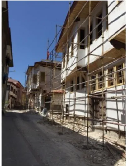
settlement areas. As such, it is indispensable to increase the perceptibility of historical urban centres, which have entered into an evacuation process, and to augment their conditions of comfort. Local governments, associations, and citizens have to assume the important task of finding solutions to problems including economic, spatial, social and political issues by prioritizing the concept of lasting and sustainable space. Also setting as a target this area to be reused, the Governorate of Tokat has put on its agenda its rehabilitation project, had the projects prepared, and initiated the implementation process as of 2017 (Figure 1).
The street rehabilitation project carried out on Halit and Gaziosmanpaşa 22nd streets, which harbours both residential and
commercial functions inside Tokat’s historical urban centre, was realized in three stages. In the first stage, in order to identify the area and to develop an understanding of its unique urban fabric, the spatial and historical infrastructure was laid down by compiling all physical data with the methods of literature review, questionnaires, interviews, and documentation. In the second stage, strategies were developed on the basis of analysis of all data and identification of existing problems, and in the third stage, planning decisions were made on the basis of assessment of all data obtained. The economic, cultural, social, and spatial analyses, as well as proposals for solution made in this project, which was conducted with a contemporary and sustainable conservation approach, will contribute to other conservation efforts in urban areas.
PROJECT AREA
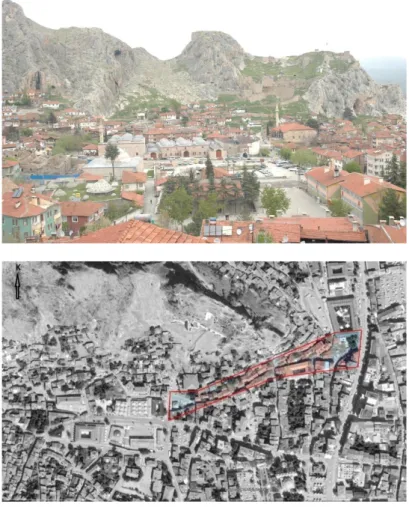
The city of Tokat, where the project area is located, is situated in the Central Black Sea Region (Figure 2). Within the provincial borders of the city, the history of which goes back to 3000 BC, are located many ancient cities such as Sebastapolis, Comano, Figure 1. Restoration works just
started in Halit Street (by the
- Vo lum e 6, Is sue 2 / P ub lis hed : D ec em ber 201 8
Maşathöyük, and Horoztepe. The current urban centre was founded inside the Castle during the Roman Period. During the Danismend reign, the city started to grow toward the southern foothills of the Castle. Urban growth continued also in the Anatolian Seljuk, Ilkhanid, and Ottoman periods. Tokat maintained its existence as a small city after the founding of the Republic, but was subject to urbanization drives in the last 15 years.
The project area is located at Halit and Gaziosmanpaşa 22nd
streets on the southern foothills of Castle of Tokat, in Kabe-i Mescid and Camii Kebir neighborhoods. Situated within the urban protection zone, these two streets are continuation of each other on the same axis, and connect the new urban centre of the city (Gaziosmanpaşa Boulevard) to the old urban centre (Sulu Street), (Figure 3). Sulu Street and its surroundings, which constitute the historical commercial centre of the city of Tokat, have retained commercial vitality up to the 1980s as one of the oldest commercial centres of the city. There are many monumental works on Sulu Street dating back to Danismend, Anatolian Seljuk, Ilkhanid, and Ottoman periods. However, as a result of the urbanization activities flourishing after the 1980s, the monumental and traditional urban fabric of Sulu Street has become derelict and transformed into a slum area. Even though restoration works have taken place on some monumental buildings in the historical urban centre (Sulu Street) in recent years, given that this area is distant to and disconnected from the
Figure 2. Satellite view of Tokat
(http://www.netkayit.com/turkiye-haritasi.php?uydudan=Tokat)
CO NAR P.2018 .55 – E -I SS N: 214 7-9380
main new transportation artery of the city, this could not integrate the area fully to the city. For this reason, the project area is in an important location as it is situated on an axis which would accomplish this integration. Halit Street, also known as Yahudiler Street among the populace, is a residential area containing traditional houses (Figure 4). Gaziosmanpaşa 22nd Street, on the
other hand, has more commercial activities. Even though there are many streets in the city which connect Gaziosmanpaşa Boulevard with Sulu Street, both streets in the project area differ from the rest as they represent a small model of the city, displaying traditional and monumental architectural buildings.
Since there were no written documents on either street, information about them was gathered through interviews made with elderly persons. These interviews revealed that Halit Street featured a church and a synagogue which did not survive up today. People aged 60 and above stated that they remembered the church, and had heard about the synagogue from their elders. Today, apartment buildings stand on the sites of these buildings. During the interview, Bozyel, a resident aged 65, explained that the traditional houses in the area were the homes of non-Muslims, that the immigrants from Salonika who came to Tokat had Figure 3. Sulu Street (by the author)
Figure 4. The project area and its surroundings (Archtech Mimarlık Ltd.
archive)
- Vo lum e 6, Is sue 2 / P ub lis hed : D ec em ber 201 8
purchased them when they were vacated during the implementation of the exchange agreement made with Greece, and that even his grandfather was an immigrant who had purchased the house they had been living in following the exchange (Interview, 2015).
PROJECT AREA FABRIC
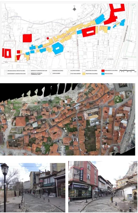
There are 64 buildings facing the two streets, including 40 traditional buildings out of which 9 are registered, 17 new buildings, 6 monumental buildings, and 1 mosque (Figure 5, 6, 7, 8). The municipality has conducted maintenance work during the early 2000s on the outer facades of traditional buildings facing Halit Street, which were not part of a project.
Figure 5. Buildings in the project area
(Archtech Mimarlık Ltd. archive)
Figure 6. Aerial photo of the project area (Archtech Mimarlık Ltd. archive)
Figure 7. Views of project area
connected with Gaziosmanpasa
Boulevard (by the author)
CO NAR P.2018 .55 – E -I SS N: 214 7-9380
Settlement Fabric and Street-Garden-Building Relations
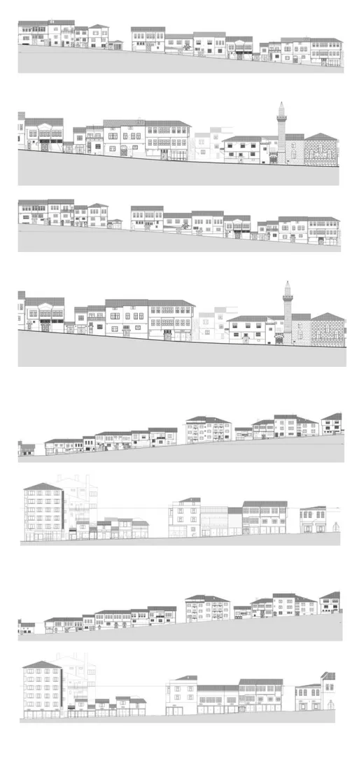
Buildings line both streets that connect Gaziosmanpaşa Boulevard with Sulu Sokak with an average elevation of 5.5 %. Houses situated on the street, the sharpest elevation of which is 8,5 % and the width of which varies between 4 to 7,5 meters, in an organic order consistent with the features of the land and its ownership. The frontal facades of the buildings face the street and demark the borders of the street. All buildings on the street are attached and situated next to each other in a row. The attached rows are broken only when giving passage to roads. 3 buildings have gardens in front, and 6 buildings have gardens at the side and at the back facades. With the exception of those with front gardens, the entrance to the buildings is accessed from the street. There are also reinforced concrete buildings in between the traditional buildings (Figure 9, 10, 11, 12, 13).
Figure 8. Views of project area
connected with Sulu Street (by the
author)
Figure 9. Views from the project area
(by the author)
- Vo lum e 6, Is sue 2 / P ub lis hed : D ec em ber 201 8
Figure 10. The survey of north silhouettes (Archtech Mimarlık Ltd.
archive)
Figure 11. The restoration of north silhouettes (Archtech Mimarlık Ltd.
archive)
Figure 13. The restoration south silhouettes (Archtech Mimarlık Ltd.
archive)
Figure 12. The survey south silhouettes (Archtech Mimarlık Ltd.
archive)
CO NAR P.2018 .55 – E -I SS N: 214 7-9380 Traditional Houses
The traditional houses on Halit and Gaziosmanpaşa 22nd streets
which have survived up until now with little alterations in the city centre represent the characteristics of traditional housing of Tokat and Central Anatolian Region. While their construction dates are not known, in consideration of the natural disasters Tokat has gone through, their construction materials can be dated back to the 19th century (Akın and Özen, 2010).
There are 24 traditional houses, out of which 9 are registered, facing the street. The ground floors of these traditional houses are service areas containing hearth, oven, and workshop. Upper floors are reserved as living spaces. These traditional houses usually have floor plans with inner and outer anterooms which are the spaces that provide passage to outdoors and the street (Akın and Özen, 2010). 8 of the traditional houses have mezzanine floors between the ground floor and the upper floor. These mezzanine floors, which also exist in many other traditional houses in Tokat, were built for residing during wintertime, and have low ceilings for easy heating.
Projections constitute the most prominent and characteristic elements of street façades and they vary a great deal. Projections of all houses, usually supported by arches, called “eli böğründe”, are built uniformly. Almost all of the traditional houses have one storey above the ground floor, and only one has two storeys above the ground floor. The outer facades are plastered with white sweet lime plaster, and their windows are proportioned by a ratio of ½ and have wooden frames. The area has 13 ground floor+one storey, 8 ground floor+mezanzine floor+one storey, and 1 ground floor+2 storey houses (Figures 14, 15, 16, 17, 18, 19, 20, 21, 22, 23, 24, 25).
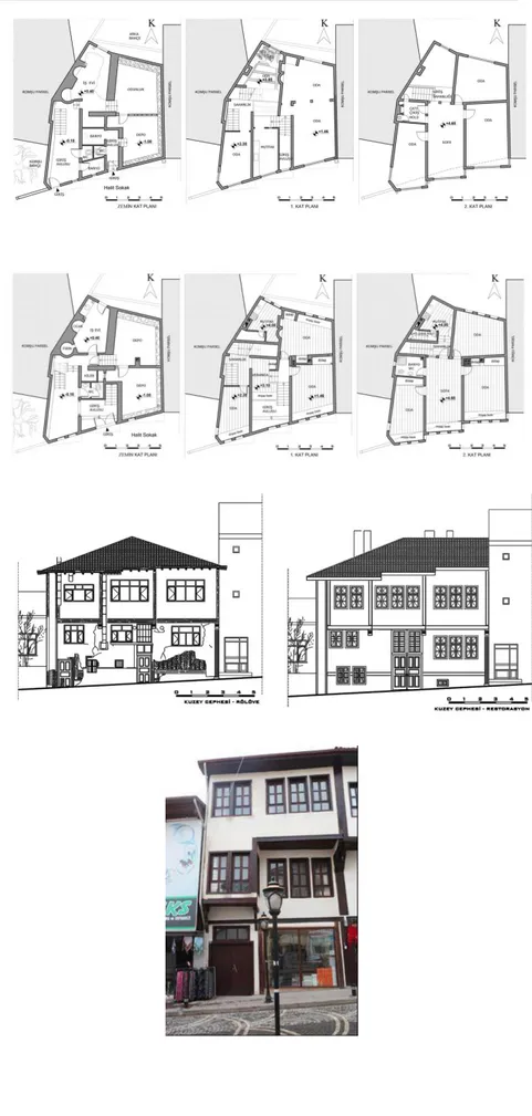
Figure 14. The traditional house at block 133, lot 109 (by the author)
- Vo lum e 6, Is sue 2 / P ub lis hed : D ec em ber 201 8
Figure 15. The survey plan of the traditional house at block 133, lot 109 (Sivas Kültür Varlıklarını Koruma
Kurulu archive)
Figure 16. The restoration plan of the traditional house at block 133, lot 109
(Sivas Kültür Varlıklarını Koruma Kurulu archive)
Figure 17. The survey and restoration façades of the traditional house at block 133, lot 109 (Sivas
Kültür Varlıklarını Koruma Kurulu archive)
Figure 18. The traditional house at block 135, lot 23 (Archtech Mimarlık
Ltd. archive)
284
3
CO NAR P.2018 .55 – E -I SS N: 214 7-9380
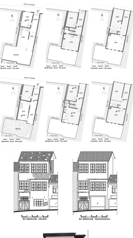
Figure 19. The survey plan of the traditional house at block 135, lot 23
(Yaprak Mimarlık Office archive)
Figure 20. The restoration plan of the traditional house at block 135, lot 23
(Yaprak Mimarlık Office archive)
Figure 21. The survey and restoration façades of the traditional house at block 135, lot 23 (Yaprak
Mimarlık Office archive)
Figure 22. The traditional house at block 135, lot 75 (Archtech Mimarlık
Ltd. archive)
- Vo lum e 6, Is sue 2 / P ub lis hed : D ec em ber 201 8
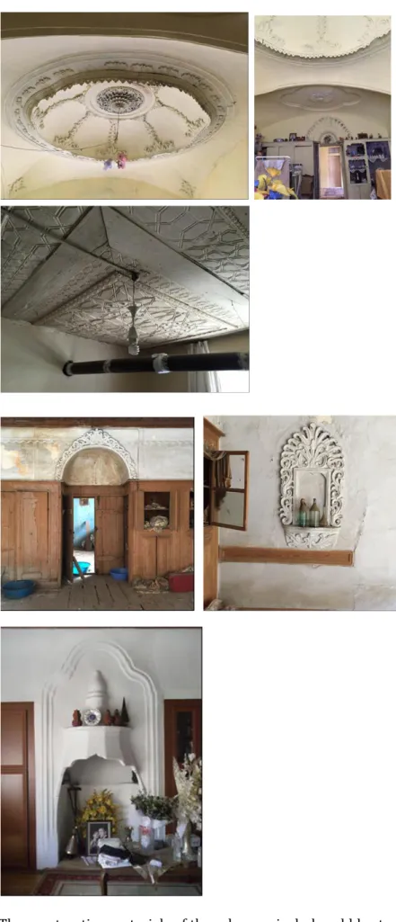
Indoor elements and decorations have the characteristics seen in Traditional Houses of Tokat. While these houses look very plain and modest from outside, their indoor decorative elements are quite ostentatious, and they feature hearths, wooden ornamentations, light fixtures, ornamented ceilings, and built-in closets (Akın and Hanoğlu, 2013) (Figures 26, 27, 28).
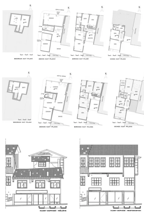
Figure 23. The survey plan of the traditional house at block 135, lot 75
(Yaprak Mimarlık Office archive)
Figure 24. The restoration plan of the traditional house at block 135, lot 75 (Yaprak Mimarlık Office archive)
Figure 25. The survey and restoration façades of the traditional house at block 135, lot 75 (Yaprak
Mimarlık Office archive)
CO NAR P.2018 .55 – E -I SS N: 214 7-9380
The construction materials of these houses include rubble stone, wood, brick, and mud brick. Their construction technique consists Figure 26. Views of interior space
of the traditional house at block 241, lot 1 (by the author)
Figure 27. A view of interior space of the traditional house at block 242, lot 9 (by the author)
Figure 28. A view of interior space of the traditional house at block 242, lot 2 (by the author)
- Vo lum e 6, Is sue 2 / P ub lis hed : D ec em ber 201 8
of building on top of a continual stone foundation a wooden structure which is filled with brick and mud filling for walls. The inner surfaces of walls are plastered with sweet lime, and their outer surfaces are plastered with mud or sweet lime. Cupboards, stairways, ceilings, and floor coverings, except for the ground floor, are wooden. Since the ground floors are mostly service areas, their floors consist of rolled earth, stone, or brick materials.
Monumental Buildings
Taşhan (Voyvoda); located at the intersection of Gaziosmanpaşa Boulevard and Gaziosmanpaşa 22nd streets, Taşhan (Stone Inn), an Ottoman period commercial building, was built between 1626-1632 (Mercan et al., 2003) (Figure 29).
Pervane Bathhouse; built as a double bathhouse, today this bathhouse is under the ownership of General Directorate of Foundations, and is in good condition and in operation. It was built in 1275 during the Anatolian Seljuk Period (Önge, 1995). The ground floor of the bathhouse, which is located on Gaziosmanpşa 22nd Street, is 2.00 meters below the current street level (Figure
30).
Yazmacılar (Gazi Emir, Gazioğlu) Inn; this two storey inn with an inner courtyard has a quadratic plan, and its construction date is unknown. Located on Gaziosmanpaşa 22nd Street, it used to be
private property, but went into the ownership of the Regional Directorate of Foundations. Today, its restoration work is complete (Figure 31).
Figure 29. Taşhan (by the author)
Figure 30. Pervane Bathhouse
(Archtech Mimarlık Ltd. archive)
CO NAR P.2018 .55 – E -I SS N: 214 7-9380
Ulu Mosque; located in Cami-i Kebir neighbourhood to the North of Halit Street, the inscription on the eastern entrance of the mosque shows the date of 1678, but this is the date of its renovation. In reality, it was built during the Seljuk period, but was damaged because of fire, earthquake, etc., and was rebuilt during the Ottoman period, based on its original foundations (Erdemir, 1986) (Figure 32).
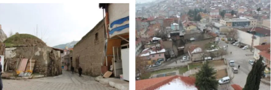
Katırcılar Inn; there is no definite information about the construction date of this dilapidated building of an inn, of which the northern façade is on Halit Street (Figure 33).
Sık Dişini Helâsı; the construction date of this building located on Halit Street is unknown. It is a single space, domed building, with unoriginal additions inside. Since it was used as toilets for a while, the populace calls it by this name. The small round windows on the dome indicate that it must have been a section of a bathhouse. The higher ground elevation of the building was lowered during the excavations conducted in 2017 to its entry elevation, and the Figure 31. Yazmacılar Inn (by the
author)
Figure 32. Ulu Mosque (by the
author)
Figure 33. Katırcılar Inn (Archtech
Mimarlık Ltd. archive)
- Vo lum e 6, Is sue 2 / P ub lis hed : D ec em ber 201 8
house attached to its eastern façade was knocked down (Figure 34).
ANALYSIS OF PROJECT AREA
Based on literature review, technical measurements, observations, research, meetings, questionnaires, and interviews about the area, a dataset was gathered regarding the 64 buildings and the streets. All buildings in the project area have been analysed in terms of registration, properties, ownership, site plans, use, and construction techniques.
Spatial Analysis Urbanism:
Located in the city centre, urbanization drives and rent pressures exert fairly strong impact on the project area and the surrounding historical centre. This causes traditional buildings located inside the urban protection zone, which are not registered as yet, to be demolished and new buildings to be erected on their spots which do not fit into the urban fabric of the area. As commercial venues abandon the historical urban centre, this causes further pressure on traditional commercial activities. Evacuated traditional houses and diminishing commercial activities have caused this area to turn into a slum and shanty area.
Physical and Functional Aging:
Interventions made to buildings over time and reasons emanating from physical conditions have caused historical buildings to age. For this reason, buildings which have not been maintained for a long time have serious structural damages (Figure 35). Buildings with structural damage and adjacent to the road are also of concern for life safety. Physical comfort conditions of buildings which have not been maintained are also not in good shape.
Figure 34. Sık Dişini Helası
(Archtech Mimarlık Ltd. archive)
CO NAR P.2018 .55 – E -I SS N: 214 7-9380
As a result of changing living conditions over time, these traditional houses also face the problem of functional aging. Given the size of contemporary nuclear family, these traditional houses are too large, which results in evacuations, sales, or renting by their owners. Some home owners habitually divide their houses with unoriginal additions and live there with a number of other families (Figure 36).
6 out of 24 of the houses built with traditional techniques were empty and 5 were used partially. New shopping malls built in the city result in functional aging of traditional commercial venues located in the area. While structural conditions of traditional buildings, where commercial activities take place are in good shape, they cause visual pollution within the street fabric.
Problems with Infrastructure:
Both streets display visual and physical deterioration caused by road and infrastructure works.
Access/Transportation:
The project area acts as a bridge between the historical urban centre and the new city centre, and is therefore in an advantageous location in terms of accessibility. Nowadays, traffic continues to flow on both directions on Halit and Gaziosmanpaşa 22nd streets. The street going in between the traditional houses is
not even, as its width varies between 4 and 7.5 meters. For this Figure 35. The structural damages
(by the author)
Figure 36. Unnecessary wall
attachment (by the author)
- Vo lum e 6, Is sue 2 / P ub lis hed : D ec em ber 201 8
reason, the street has no sidewalks, and no pedestrian and disabled safety. Additionally, passing vehicles cause buildings adjacent to the street to tremble and damage their structures.
Socio-Economic and Cultural Analysis
All places acquire their characters over time that reflect current and past actions and shared values of society, as well as their unique soul, culture, and history. Traditional settlements also reflect the soul of society in concrete terms. This concretefabric, developed by layering of accumulations over the years, evinces the traces of the past, and is unique (Conzen, 1960; Conzen, 2004; Koca, 2015). For this reason, conservation projects in historic urban centres carried out of this context are not expected to be successful.
In order to conduct socio-economic and cultural analyses in the project area, questionnaires, interviews, and meetings were conducted. On both streets, where approximately 200 persons live, questionnaires were implemented by random sampling to three groups, made of those who were engaged in commercial activities, those who lived in traditional houses, and those who lived in new housing. Questions regarding socio-economic and cultural situation of persons living in the area, and their problems and expectations regarding the street were asked. In addition, two meetings were organized during the project preparation stage with the inhabitants in the area and the authorized public administration in order to evaluate the project process.
Persons living in both the traditional and new houses consisted of illiterates by 3 %, and graduates of primary school by 50 %, middle school by 15 %, high school by 20 %, and university by 12 %. 95 % of women were housewives. Of men, 60 % were retirees, 10 % government employees, and the rest were working at minimum wage or in temporary jobs. The level of income of these families was middle and lower middle income, and households consisted of 2 to 5 persons. 50 % of residential and commercial buildings were rented. Out of those who were engaged in commercial activities, 21 % were graduates of primary school, 5 % middle school, 38 % high school, and 36 % university. Their level of income was middle and upper middle income.
According to the results of questionnaires, as the buildings in the project area are in a process of being evacuated due to spatial problems, usually the traditional houses were either rented out or sold to families with low levels of income and education who have migrated from rural areas. There are also refugee groups living in traditional houses with low rents. For these reasons, the
socio-292
CO NAR P.2018 .55 – E -I SS N: 214 7-9380
economic and cultural structure of the area has changed considerably.
The reasons for living in these houses were stated as economical by 72.73 %, proximity to work/school by 22.73 %, and the house being the ancestral home by 4.55 % (The answer stating economical reason was statistically significant, chi²=16.46, p<0.05). The reasons for engaging in commercial activities in this area were stated as customer loyalty by 68 %, proximity to the centre as 21.05 %, and time spent by 5.26 % (The answer stating customer loyalty was statistically significant, chi²=14.63, p<0.05). Some of the statistical analysis results of the questionnaire conducted in the area regarding the streets are provided in Table 1.
Table 1. The results of questionnaire analysis
Questions Yes
% No % Undecided % Significance level (Those who answer “yes”)
Satisfied with life
on the street 78.05 12.20 9.7 chi²=36.93, 0.05 p˂
Neighborhood relationships are friendly and sincere 75.61 12.20 12.20 chi²=32.98, p˂0.05 Feels belonging to
the street 70.73 12.20 17.07 chi²=25.95, p˂0.05
Must be a craft on
the street 92.68 4.88 2.44 chi²=65.02, p˂0.05
Restaurant should be opened on the street
73.17 26.83 - chi²=8.80, p˂0.05
Must be resting
places on the street 90.24 9.76 - chi²=26.56, p˂0.05
Should the area be
open for tourism? % 85.37 % 7.32 % 7.32 chi²=49.95, p˂0.05
Should the area be
cultural street % 92.68 % 7.32 - chi²=29.88, p˂0.05
The largest problem facing the project area, having been subject to in and outmigration due to changing living conditions and dereliction, is neglect and poverty. Local governments have important tasks to assume in order to overcome these problems. Since overcoming these problems necessitates large budgets, single institutions will not be able to tackle them. Therefore, a joint effort of all public institutions will be the starting point to overcome these problems. As a first step, the Provincial Directorate of National Education should offer courses on small handicrafts, music, folklore, and education geared especially toward women and the youth living in the area.
- Vo lum e 6, Is sue 2 / P ub lis hed : D ec em ber 201 8 Legal Condition
As it is the case in the rest of the world, also in Turkey, the management process of cultural endowments is usually realized within the state organization. Started in the Ottoman times, this organization has also continued in the Republican period. The most comprehensive regulation in Turkey that sets out the rules for all types of research, conservation and management of cultural and natural endowments is the Conservation of Cultural and Natural Endowments Law no 2863 passed in 1983, and today’s regulations are all based on this law. The actors in the public administration for cultural endowments include Ministry of Culture and Tourism, General Directorate of Foundations, General Directorate of National Palaces, and Ministry of National Defence at the central government level, and municipalities and provincial special administrations at the local level (Aksoy et al, 2012). In Tokat, decisions regarding specification of the protection area and building conditions were first taken in 1984, and 181 real properties were registered as cultural endowments in the same year. Up until now, registered and unregistered traditional houses in Tokat have been subject to an understanding of conservation at a single building scale. Nevertheless, conservation strategies are needed which would ensure that these buildings would be converted to more liveable spaces and would be integrated to the city. With regard to the conservation of these products, these strategies need to be specified, even though there is a legal framework in Turkey, but its implementation has many dimensions. For this reason, area/management plans, which would include long term conservation strategies, need to be prepared for Tokat in the shortest time possible in order to carry this heritage to the future.
Spatial, legal, socio-economic, and cultural problems witnessed in the project area in recent years have brought about multi-faceted challenges in the area. The leading problem is with regard to multi-owner title deeds of buildings which are legally transferred by inheritance. There are also problems with owners not wishing registration of their unregistered houses, or owners who try to unregister their registered houses. Carrying out restoration work in traditional homes occupied by low-income people, half of whom are tenant, is especially very difficult. Even though there are incentives granted by the State for restorations, they remain insufficient. Out of the 24 qualified traditional houses, including 9 registered ones, in the project area, only 4 have had undergone restoration, which is due to the low level of income of inhabitants.
294
CO NAR P.2018 .55 – E -I SS N: 214 7-9380
ASSESSMENT AND CONSERVATION DECISIONS
Since the project area does not have more attractive power than other streets, despite its traditional urban fabric and importance in history, a decision was made to convert this area into a centre of attraction. For this purpose, assessments were made at the urban scale in communication and cooperation with the users of the area and the authorized public administration to ensure that conservation work would be guided in an integrated and sustainable manner. All analyses regarding increasing spatial, socio-economic, cultural, infrastructural, and accessibility qualities, as well as user demands, which would bring about solutions to the fundamental problems of the project area, were assessed in terms of “strengths/ weaknesses” and “opportunities/threats” of the project area (Table 2).
Table 2. Strengths, Weaknesses, Opportunities, and Threats STRENGTHS
Location of streets in historic urban core
Location of streets in urban centre (accessibility)
Traditional, unique urban street fabric
Existence of monumental buildings
Existence of an economic structure brought about by history, art, and culture
Existence of traditional production together with historic commercial areas
Retaining local culture
WEAKNESSES
Squalidness of traditional houses Squalidness of the street giving rise to a
safety problem
Location of area within a shanty town area
Poverty and low level of living quality The shifting of commercial area to the
new settlement region of the city Traffic and parking problems Insufficiency of social facilities
The area not being recognized by visitors coming from outside the province
Lack of holistic approach /holistic conservation
OPPORTUNITIES
The street being the gate opening to the historical centre of the city The existence of an inn, the
restoration of which was recently completed
The support and significance assigned by current central and local governments to conservation work
THREATS Rent pressure Financial problems
Problems with expropriation New buildings spoiling the silhouette Lack of precautions against fire Substandard building stock
Evacuating inhabitants and trades people
Lack of regulatory plans such as tourism plans, visitor management plans, Wrongful restorations
These analyses which were made in the rehabilitation project that has the objective of making both streets a gate and centre of attraction between the new axis of the city and the historical urban centre, were helpful in setting out the conservation strategies. The conservation strategies of the street rehabilitation project were set as follows:
Making sure that street rehabilitation is integrated to the city by a thorough analysis of historical background of the city, its
- Vo lum e 6, Is sue 2 / P ub lis hed : D ec em ber 201 8
cultural heritage, spatial development, socio-economic and cultural infrastructure, and contemporary life styles
Conservation of the accumulation of the historic urban fabric, traditional houses, and monumental buildings located in an important area of the historic urban core
Contributing to increasing living/environmental qualities Strengthening the physical and functional ties between
buildings by evaluating all buildings on the street as a whole Creating social areas in order to instigate a sense of belonging Generating consciousness of conservation of the historic
environment
Integrating the area, which is located in the commercial centre, to the local economy
Ensuring health and safety conditions
Ensuring unity and continuity in pedestrian and vehicular transportation between the project area and the rest of city and its environs in terms of function and spatial arrangements, etc.
Ensuring physical, functional, social, and economic development of the area
Evaluating each area by their unique qualities
Ensuring intervention to unexpected situations even during the implementation phase by providing feedback.
Appropriate conservation interventions were done in accordance with these strategies by assessing socio-economic, cultural, and spatial structures in the area. As a priority for increasing the spatial quality, restitution and restoration projects for all buildings on the street were prepared geared toward renovation of their façades.
In the rehabilitation project prepared for sustenance and integration of the area with the city, three target groups were selected in this order: inhabitants of the street, city dwellers, and visitors. One key objective of the project was to conserve the traditional housing settlement to be used 24 hours. For this purpose, when the activities were being planned, empty traditional houses not used by the inhabitants of the street were identified and were given appropriate functions, also in line with the results of the questionnaires. New functions were planned to allow for the socio-cultural continuity, and consequently, new social activity areas were created. The creation of environments in which traditionalized cultures can be exercised and cultural activities can be organized will ensure that the area is used more frequently in Tokat’s cultural life. For example, promotional day festivities can be organized for traditional events (such as bathhouse parties, henna nights for brides), preparation of
296
CO NAR P.2018 .55 – E -I SS N: 214 7-9380
traditional foods (such as grape molasses, tomato paste, cured grape leaves), or traditional handicrafts (such as Tokat’s hand-printed cloths). People getting lonelier in a steadily globalizing world appears to be a social problem. From this point of view, such organizations would make possible for the people to gather and get socialized, and engender a sense of belonging and loyalty to place and space in persons. Higher quality, more liveable spaces would increase the number of qualified users in this area. In the project area, which would start to be used more intensively, along with the traditional living culture generated, people’s consciousness would be increased about conservation of the historical environment.
For this purpose, an unused, registered traditional house with ground floor+2 storeys was identified for holding courses on by gone handicrafts, music, etc., as part of the social activities to be undertaken on the street (Figure 37). The front and side facades of this traditional house with an L shaped plan, located at block 242, lot 1, seemed to be damage-free, but there were collapsed areas at the back façade and inside. This large traditional house, situated at the corner of a four-road intersection, features many properties of Tokat’s traditional houses. In consideration of its accessible location within the area and its size, it was assigned the function where cultural activities would be conducted.
In consideration of tourism activities for groups of visitors in the city and the street, a boutique hotel was proposed within the traditional urban fabric. For this function, an empty, registered traditional house was selected, which was the largest house with the largest garden on the street (Figure 38). Structurally this house, located at 243 block, lot 5, is not in good condition. It has a floor plan arranged around an inner anteroom. Despite some of the later additions, this floor plan is original. In consideration of the size of the building, the number of rooms, and the existence of Figure 37. A view of the traditional
house at block 242, lot 1 (by the
author)
- Vo lum e 6, Is sue 2 / P ub lis hed : D ec em ber 201 8
a backyard, it was considered to be suitable for the function of a boutique hotel.
The traditional house, located at block 242, lot 9, was selected as a venue where Tokat’s local food would be served to all users, and which would also be used for small organizations (Figure 39). The front and side façades of this traditional house with ground floor+mezzanine+1 storey are adjacent to the street and the building thus has an L shaped floor plan. The entryway is from the front façade and it opens into a hallway. This hallway, the ceiling of which is covered with the floor planks of the first floor, opens directly into the garden. The surrounding anteroom on the L-shaped upper floor is open to outdoors, and thus the building has a floor plan with an outer anteroom. This type of floor plan having an outer anteroom, where passage between rooms is made possible in the open, was also encountered in the Yağcıoğlu Mansion in Tokat. In consideration of the size of this traditional house and the existence of a workshop, fountain, kebab range, and oven in its large garden, the ground floor was assigned the function of a restaurant, and the upper floor to be used for social organizations and meetings.
Figure 38. A view of the traditional house at block 243, lot 5 (by the
author)
Figure 39. A view of the traditional house at block 242, lot 9 (by the
author)
CO NAR P.2018 .55 – E -I SS N: 214 7-9380
Small cafés and shops selling small souvenirs were also envisaged. Empty buildings with physical properties appropriate to these functions were selected. Existing commercial buildings were used with the same functions.
These streets contain three inns, a bathhouse, and two mosques which can actively be used. Located at the intersection of Gaziosmanpaşa Boulevard and the Gaziosmanpaşa 22nd streets,
Taşhan is still in use today. Located on Gaziosmanpaşa 22nd Street,
Yazmacılar Han, the restoration of which has been completed, was considered for use by workshops and shops where courses for the vanishing hand-printing of cloths would take place. Tokat has a great bathing culture, and the Pervane Hamam in the project area is expected to keep on with this tradition. Katırcılar Han in the area was proposed to be restored as a social facility with both open and closed spaces following its immediate expropriation. In addition, Ulu Camii will have programs ensuring that larger crowds have access to the street.
The integration of buildings with the street was realized with landscaping and planting arrangements appropriate to the functions assigned in accordance with the needs of the inhabitants of the street and the city. Resting and sitting areas were erected in order to facilitate socialization, and in consideration of the length and elevation of the street (Figure 40). Since the traffic flow on both streets has been creating problems for buildings and pedestrians, vehicular traffic was removed from the area, allowing access to the street only for emergencies. Roads and car parks parallel to these streets at south and north will have capacity to solve the traffic problem. In addition, in the landscaping project, a walkway and signs for the disabled, and a playground for children were realized. Projects and arrangements were done in order to solve the disorder created by electric and phone posts, advertisement boards, infrastructure lines, and the like. All additions which would cause visual pollution were removed from the façades of shops in the commercial area, and instead, nameplates and showcases suiting the traditional urban fabric were proposed. In order to ensure that the area is visible, usable and safe at night time, a lighting project was done. The materials used in outdoor spaces throughout the street were selected to complement each other, so that the street would be perceived as a unified place.
- Vo lum e 6, Is sue 2 / P ub lis hed : D ec em ber 201 8 CONCLUSION
The capitalist system contradicts with values based on esthetical, environmental, and qualitative criteria in fast growing cities and in cities where land and ownership are abused. Also Larkham (1996) notes that this contradiction is a large problem unsolvable theoretically in terms of qualities and scale, as there is not one single theory about how to manage conservation and implementation in historical buildings and urban landscapes, which has many dimensions. For this reason, in recent years it has been widely accepted that instead of the limiting meaning of the concept of “protection areas”, one should adopt certain policies that deal with settlements as a socio-cultural and spatial whole inclusive of their layers, and approach them with the concept of “historical urban landscaping”. These policies necessitate considering what is historical and what is modern jointly, and acknowledging the relationships between local identity, spatial quality, economic well-being, and social harmony. As such, controls over financial resources and decision making processes should also evolve into partnership, consultation, and cooperation between the state and the actors of the market and civil society (Dinçer, 2013). The conservation action, which means managing change in cities, as living organisms, should be at the same time flexible and in tune with changing times.
We observe that generally conservation projects in Turkey are not handled in a multi-dimensional way, and the tendency of making visitor-oriented physical interventions by creating museums or boutique hotels detached from their context is quite common. In a small city like Tokat, where there is a traditional housing stock with more than 140 registered houses and as many unregistered ones, it is not feasible to convert all of them into boutique hotels or museums from the perspective of sustainable conservation. Nevertheless, given the fact that visitors wishing to get to know different cultures and learn about other people’s lives would like
Figure 40. An elderly resting on the street (by the author)
CO NAR P.2018 .55 – E -I SS N: 214 7-9380
to see and experience that culture in its physical environment, it is important that traditional way of living survives in these areas. The strategic decisions made in the street rehabilitation project have focused on conservation as something more than physical improvement. In this respect, a SWOT analysis was carried out concerning the holistic conservation of the traditional urban fabric. In addition to this analysis, priorities and conservation strategies were identified based on questionnaires, interviews, and meetings. The important issues in restoring the unique identity of both streets were physical repairs, landscaping arrangements, identifying traditional life styles, revealing the cultural way of life, and the assigned new functions. In a holistic conservation approach, through which the street sustains its commercial activities and residential living inside the urban centre together with monumental buildings, the project does not transform these streets into a museum but makes them streets having a life not detached from its past. For Tokat, a city with a very rich historical and cultural heritage, this project will serve as a precedent for the preparation of area/management plans for conservation and implementation in other historical areas of the city.
ACKNOWLEDGEMENT
This research was developed from the ‘’Halit and Gaziosmanpaşa
22nd streets feasibility project’’ that was undertaken by Tokat
Teknopark Archtech Architecture Restoration Consulting Limited Company. This project was made to Tokat Provincial Directorate of Culture and Tourism with the support of OKA (Middle Blacksea Development Agency). The restoration, restitution and restoration drawings of the area which constitutes the subject of article have been drawn by Asst. Prof. Dr. Emine Saka Akın, Asst. Prof. Dr. Aygün Kalınbayrak Ercan and Res. Asst. Elif Yaprak Başaran.
REFERENCES
Akın, E. S. and Özen, H. (2010). Tokat Geleneksel Evlerinin Beyhamam ve Bey Sokak Örneğinde İncelenmesi, The Black Sea Journal of Social Science (2) 167-182.
Akın, E. S. and Hanoğlu, C. (2013). Tokat Geleneksel Konut Mimarisi’nde İç Mekân Alçı Süslemeleri, Vakıflar Dergisi (40) 163-184.
Aksoy, A., Enlil, Z., Ünsal, D., Pulhan, G., Dinçer, İ., Gülersoy, N. Z., Ahunbay, Z. and Köksal, G. (2012). Kültürel Miras Yönetimi, T.C. Anadolu Üniversitesi Yayını, I. Baskı, Web-Ofset, Eskişehir.
Ayrancı, İ. and Gülersoy, N. Z. (2009). Bay Tarihi Çevrede Koruma: Yaklaşımlar, Uygulamalar, Dosya-14, TMMOB Mimarlar Odası Ankara Şubesi Yayını, Ankara, 73-79.
- Vo lum e 6, Is sue 2 / P ub lis hed : D ec em ber 201 8
Brüggemann, S. and Schwarzkopf, C. (2001). Erfurt, Germany, Management of Historic Centres, ed. R. Pickard, Spon Press Taylor and Francis, London; 113-132.
Conzen, M. R. G. (1960). Alnwick, Northumberland: A Study in Town Plan Analysis, Institute of British Geographers, London. Conzen, M. R. G. (2004). Thinking About Urban Form – Papers on
Urban Morphology: 1932-1998, Peter Lang, Bern.
Çahantimur, A. (2008). Sürdürülebilir Kentsel Gelişmeye Sosyokültürel Bir Yaklaşım: Bursa Örneği, İTÜ Dergisi 7 (2) 3-13.
Dinçer, İ. (2013). Kentleri Dönüştürürken Korumayı ve Yenilemeyi Birlikte Düşünmek: “Tarihi Kentsel Peyzaj” Kavramının Sunduğu Olanaklar, ICONARP1 (1) 22-40. Enlil, Z. (1992). Tarihi Bir Çevreyi Yaşatmak: Paris ve Bologna’da
Bütüncül Koruma Yaklaşımları, YTÜ Mimarlık Fakültesi Yayını, Mf Şbp 92.039/02, 199-204.
Enlil, Z. (2000). Yeniden İşlevlendirme ve Soylulaştırma: Bir Sınıfsal Proje Olarak Eski Kent Merkezlerinin ve Tarihi Konut Dokusunun Yeniden Ele Geçirilmesi, Domus, No:8, 46-49.
Erdemir, Y. (1986). Tokat Yöresindeki Ahşap Camilerin Kültürümüzdeki Yeri, Türk Tarihinde ve Kültüründe Tokat Sempozyumu, Temmuz, Gelişim Matbaası, Bildiriler Kitabı, Ankara, 295-312.
Gospodini, A. (2002). European Cities in Competition and the New ‘Uses’ of Urban Design, Journal of Urban Design, 7(1) 59-73.
Gospodini, A. (2004). Urban morphology and place identity in European cities: built heritage and innovative design, Journal of Urban Design, 9(2) 225-48..
Güvenç, B. (1974). İnsan ve Kültür, İkinci Baskı, Remzi Kitabevi, İstanbul.
Interview 2015. A resident in Halit Street.
Koca, F. (2015). Türkiye’de Geleneksel Yerleşim Örüntülerinin Özgün Karakter ve Kültürel Mirasını Koruma Anlayışına Ontolojik Bir Yaklaşım, Planlama 2015; 25 (1):32–43. Larkham, P. J. (1996). Conservation and the City, by Routledge,
London and New York.
Mercan, M. and Ulu, M. E. (2003). Tokat Kitabeleri , Türk Hava Kurumu Basımevi İşletmeciliği, Ankara.
Online Satellite Photo [http://www.netkayit.com/turkiye-haritasi.php?uydudan=Tokat] Retrieved on (12.04.2015). Önge, M. Y. (1995). Anadolu’da XII-XIII. Yüzyıl Türk Hamamları,
Vakıflar Genel Müdürlüğü Yayınları, Ankara.
Özcan, K. (2009). Sürdürülebilir Kentsel Korumanın Olabilirliği Üzerine Bir Yaklaşım Önerisi: Konya Tarihi Kent Merkezi Örneği, METU.JFA.2009.2.1, 1-18.
Schulz, C. N. (1980). Genius Loci-Towards a Phenomenology of Architecture, Academy Edition, London.
Şahin Güçhan, N. (2014). Tartışma I- Koruma Yaklaşımları ve Uygulamaları İçinde Sivil Mimarlık, Korumada Sivil Mimarlık Çalıştay Notları, VEKAM, Ankara, s. 105.
CO NAR P.2018 .55 – E -I SS N: 214 7-9380
Tiesdell, S., Oc, T. and Healt, T. (1996). Housing-Led Revitalization, Historic Urban Quarters, Reprinted 1998, Printed in Great Britain by MPG Books, London, s. 97-129.
Resume
Emine Saka Akın works at Bozok University, Department of Architecture, as an Asst. Prof. She got her B. Arch, MSc. and PhD. degrees in Architecture from Karadeniz Technical University, Faculty of Architecture in 1992, 1996 and 2009, respectively. She worked as an research assistant at Karadeniz Technical Univesity from 1992 to 1996. Major research interests include restoration, adaptive re-use, rehabilitation, urban conservation and renovation.