The Effect of Terrain Roughness in the Microwave Line-of-Sight Multipath
Fading Estimation Based on Rec. ITU-R P.530-15
Polat G¨okta¸s*1, Ayhan Altınta¸s1,2, Satılmis Top¸cu2, and Ezhan Kara¸san1
1Department of Electrical and Electronics Engineering, Bilkent University, Ankara 06800, Turkey
[email protected], [email protected] and [email protected]
2 Bilkent University - ISYAM, Ankara 06800, Turkey
Abstract
Multipath fading is an important constraint on the prediction of path loss for terrestrial line-of-sight microwave links. The International Telecommunication Union - Radiocommunication (ITU-R) Rec. P.530 [1] is one of the most widely used methods providing guidelines for the design of terrestrial line-of-sight links. The purpose of the study presented in this paper is to make an investigation of the effect of both terrain roughness and geoclimatic factor parameters in the path loss characteristics of microwave lineofsight (LOS) propagation in NATO Band 3+ (1350 -2690 MHz) and NATO Band 4 (4440 - 5000 MHz) frequency ranges. The two parameters led to significantly different results for the link availability due to multipath fading as a function of the fade margin.
1. Introduction
The estimation of path loss and link availability is necessary for the design of line-of-sight radio-relay systems. A worldwide path loss prediction model has been recommended by the Radiocommmunication Sector of the Inter-national Telecommunication Union (ITU-R) in Recommendation ITU-R P.530 [1]. This recommendation is used to predict both path loss and link availability in the average worst month for microwave links. Rec. ITU-R P.530 [1] path loss prediction model is composed of four significant clear-air and rainfall propagation mechanisms on terrestrial line-of-sight links: fading or enhancement due to multipath effects, diffraction loss over terrain obstruction, attenuation due to hydrometeors and depolarization (XPD). This paper focuses on multipath propagation model in clear-air environment for terrestrial line-of-sight links.
In this paper, we first analyse the theoretical prediction method of flat fading (such as worst month outage proba-bility) based on Rec. ITU-R P.530. Then, we define how to find out the standart deviation of terrain height and investigate the effect of terrain roughnesss on the worst month outage probability for an example link in Istanbul, Turkey.
2. Mathematics of Multipath Fading Model
Link unavailability due to multipath fading in the average worst month depends on the effects of climate and terrain data. Sa [1] is defined as the standard deviation of terrain heights (m) within a 110 km × 110 km area in Rec.
ITU-R P.530. The worldwide data for this parameter is provided by ITU-R Study Group 3.
Another parameter needed to calculate the link availability of terrestrial line-of-sight links is the geoclimatic factor. There are two ways to calculate this parameter: a quick calculation (QC) method and a detailed link design (DLD) method.
• The quick calculation (QC) method uses only, dN1 [1, 2], point refractivity gradient in the lowest 65 m of the
atmosphere not exceeded for 1% of an average year as shown in Equation (1). The worst month outage probability, pw, is calculated by using Equations (2) and (3) in the quick calculation (QC) method.
ITU-R P.530-15 [1] Quick Calculation Method
K = 10−4.6−0.0027dN1 (1) po= Kd3.1(1 + |εp|)−1.29f0.8× 10−0.00089hL (2) pw= po× 10 −A 10 (3) 978-1-4673-5225-3/14/$31.00 ©2014 IEEE
• The detailed link design (DLD) method uses both dN1and Saparameters as shown in Equation (4). The percentage
of time that fade depth A (in decibels) is exceeded in the average worst month is calculated by using Equations (5) and (6).
ITU-R P.530-15 [1] Detailed Link Design Method K = 10−4.4−0.0027dN1(10 + S a)−0.46 (4) po= Kd3.4(1 + |εp|)−1.03f0.8× 10−0.00076hL (5) pw= po× 10 −A 10 (6)
The parameters dN1, Sa, |εp| and hL significantly affect the fade occurrence factor, po and unavailability due to
multipath fading probability, pw. Equations (3) and (6) are used for a deep-fading prediction method (for small percentage
of time) but for all percentage of time A must be replaced by At, the fade depth at which the transition occurs between
deep-fading and shallow-fading distribution.
3. Impact of Terrain Roughness Parameter in Multipath Fading Estimation
We calculate the standard deviation of terrain heights, Sa which is a parameter in the performance prediction of the
microwave radio links. The method calculates the mean of the terrain heights in a specified window around the point of interest as shown in Equation (7).
¯
x =
nP
i=1x
in
(7)Then, the standard deviation of the terrain heights (σ) is calculated according to the following equation
σ = s n P i=1 (xi− ¯x)2 n − 1 (8)
where n= number of path profile points
xi= height (above sea level) of the i-th profile point
The worldwide Sa data provided by ITU-R is too coarse such that the distance between grid points is 110 km. If the
path distance between transmitter and receiver sites is less than 110 km, Sa parameter is computed by using bi-linear
interpolation of four gridpoints. We change the resolution of terrain roughness data and investigate its effect on the link availability. The path profile between transmitter and receiver sites is constructed by using a Digital Map in DTED format that has a resolution of 3×3 seconds (approximately 100 meters). Terrain roughness data is provided with the different moving window sizes. Different resolutions of Sa and the number of terrain points used in the calculation of Sa are given
in Table 1.
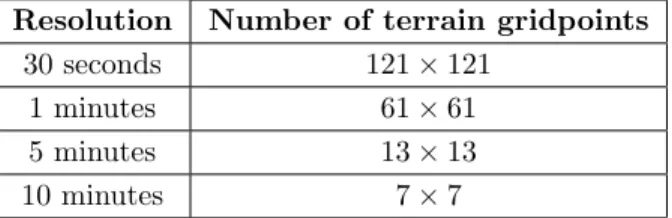
Table 1. Different resolutions of Sa and number of terrain points in Sa data file
Resolution Number of terrain gridpoints 30 seconds 121 × 121
1 minutes 61 × 61 5 minutes 13 × 13 10 minutes 7 × 7
To confirm this observation on the link availability, we applied simulation on terrestrial line-of-sight link located in Istanbul, Turkey. Figure 1 shows base station sites for microwave links studied in Istanbul. The path length of the C¸ ataltepe - Beylikd¨uz¨u radio link is 55.448 km. The main parameters of this link are summarized in Table 2. As illustrated in Figure 2, clearance of the first Fresnel zone is investigated in the microwave link analysis. The path profile of the link is used in the analysis considering the curvature of the Earth.
Table 2. Terrestrial link parameters for C¸ ataltepe - Beylikd¨uz¨u microwave LOS link
Parameter Description
Transmitter Station C¸ ataltepe 41oN 020 58.0000 29o E 170 48.00” Receiver Station Beylikd¨uz¨u 41o N 010 06.00”28o E 380 17.00”
Altitude of transmitter station
(a.s.l) 300 m
Altitude of receiver station
(a.s.l) 150 m
Height of receiving antenna
(a.g.l) 20 m
Radio Frequency 2 GHz
Path Length 55.448 km
Path Inclination 2.69 mrad
dN1 -451.5 N-units/km
Free Space Loss 133.4 dB
Figure 1. Location of sites used for microwave link Figure 2. Cataltepe - Beylikd¨uz¨u Radio Link LOS simulation in Istanbul, Turkey Analysis, first Fresnel zone is indicated by the curve
under the LOS path
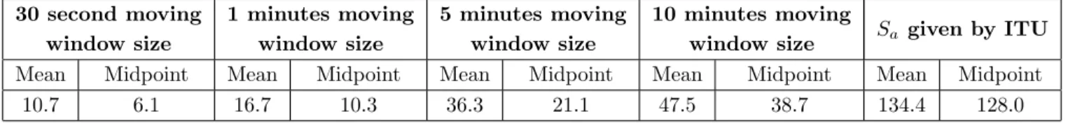
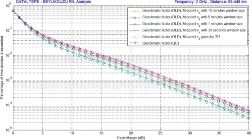
In this paper, there are two different ways to calculate terrain roughness parameter: mean and midpoint path profile point. In the first case, the associated latitude and longitude of each profile point is determined along the C¸ ataltepe -Beylikd¨uz¨u path using a fixed distance increment. Terrain roughness data is found at each profile point in this radio link. Another investigation parameter is the impact of the midpoint terrain roughness on the link availability in example radiolink. The coordinates of the midpoint is obtained from the average of transmitter and receiver site coordinates. If the location coordinates along the path are different from the gridpoints, the standard deviation of terrain heights at the desired location is computed by performing a bi-linear interpolation on the values at the four closest gridpoints. The results are summarized in Table 3. The comparison of the results are presented on Figure 3(a) to Figure 3(b) in terms of predicted worst month unavailability.
Table 3. Terrain roughness data (Sa) for different window size in C¸ ataltepe - Beylikd¨uz¨u microwave LOS link
30 second moving window size 1 minutes moving window size 5 minutes moving window size 10 minutes moving
window size Sa given by ITU Mean Midpoint Mean Midpoint Mean Midpoint Mean Midpoint Mean Midpoint
(a) Predicted worst month unavailability as function of midpoint terrain roughness value
(b) Predicted worst month unavailability as function of mean terrain roughness value
Figure 3. Percentage of time (pw) that fade depth (A) is exceeded in an average worst month
4. Conclusion
The multipath fading outage prediction method proposed by Recommendation ITU-R P.530 [1] is studied. We compared two methods of terrain roughness calculation on terrestrial microwave line-of-sight links. The effect of geoclimatic factor and different resolutions of terrain roughness data is investigated on the worst month link unavailability in C¸ ataltepe - Beylikd¨uz¨u microwave radio link. At the fixed unavailability (pw=10−3), fade margin can change up to 5 dB
as shown in Figure 3. It can be seen that multipath fading prediction model with the terrain roughness data provided by ITU is optimistic. The future work will be focused on field measurements which will be used for better comparison of simulation results.
5. References
1. International Telecommunication Union,“Propagation data and prediction methods required for the design of terrestrial line-of-sight systems,” Recommendation ITU-R P. 530-15, 2013.
2. International Telecommunication Union, “The radio refractive index: its formula and refractivity data,” Recom-mendation ITU-R P. 453-10, 2012.