N.
İlgi Gerçek*
Hittite Geographers: Geographical
Perceptions and Practices in Hittite Anatolia
https://doi.org/10.1515/janeh-2017-0026Abstract: Hittite archives are remarkably rich in geographical data. A diverse array of documents has yielded, aside from thousands of geographical names (of towns, territories, mountains, and rivers), detailed descriptions of the Hittite state’s frontiers and depictions of landscape and topography. Historical geogra-phy has, as a result, occupied a central place in Hittitological research since the beginnings of the field. The primary aim of scholarship in this area has been to locate (precisely) or localize (approximately) regions, towns, and other geogra-phical features, matching Hittite geogrageogra-phical names with archaeological sites, unexcavated mounds, and—whenever possible—with geographical names from the classical period. At the same time, comparatively little work has been done on geographical thinking in Hittite Anatolia: how and for what purpose(s) was geographical information collected, organized, and presented? How did those who produce the texts imagine their world and their homeland,“the Land of Hatti?” How did they characterize other lands and peoples they came into contact with? Concentrating on these questions, the present paper aims to extract from Hittite written sources their writers’ geographical conceptions and practices. It is argued that the acquisition and management of geographical information was an essential component of the Hittite Empire’s administrative infrastructure and that geographical knowledge was central to the creation of a Hittite homeland.
Keywords: hittite, hittites, hatti, historical geography, cosmology
Hittite archives comprise around 30,000 cuneiform tablets including frag-ments, covering a period just shy of 500 years, from the formation of the Hittite polity around 1650 BCE in the area within the bend of the Kızılırmak River, through its acquisition of an empire that stretched from the Aegean coast of Anatolia to northern Syria and Mesopotamia, and to its subsequent demise in the mid twelfth century BCE. These archives have yielded a wealth of geographical data, remarkable both in abundance and detail. Aside from
*Corresponding author: N.İlgi Gerçek, Department of Archaeology, Bilkent University, Ankara, Turkey, E-mail: [email protected]
thousands of geographical names (i. e., names of towns, territories, mountains, rivers), we have descriptions of landscapes and places from a diverse array of textual sources.1 Historical geography has consequently occupied a central place in Hittitological research since the beginnings of the field. The principal aim of research in this area has been to locate (precisely) or localize (approxi-mately) regions, towns, and other geographical features, matching Hittite geographical names with archaeological sites, unexcavated mounds, and— whenever possible—with geographical names from the classical period.2 Current research in Hittite historical geography has introduced new approaches, methodologies, and research questions from related fields such as political geography and landscape studies.3 However, in the formidable
secondary literature on Hittite historical geography, there is very little on geographical thinking and practice in Hittite Anatolia. How did those who produced the texts imagine their world and their homeland? How did they describe other lands and peoples they came into contact with? What was the extent of geographical knowledge? How and by whom was such information collected, organized, and communicated? By addressing these questions, the present contribution aims to extract from Hittite written sources their writers’ geographical conceptions and practices, moving from the more general (i. e., cosmological ideas, perceptions and representations of the Hittite“homeland,” characterizations of the “foreign”) to the more specific (i. e., the production and transmission of geographical information). The following caveats should be mentioned at the outset: Firstly, the archives do not represent the world-views and geographical notions of the Hittite state’s subject populations, but only of its ruling classes who produced the written documentation. Secondly, the geographical perceptions, interests, and practices of those who produced the texts cannot be expected to have remained static in the roughly 500 years covered by the archives. However, the available evidence—scattered across chronologically and generically diverse documents—hardly allows a more nuanced diachronic investigation.
1 According to Kryszeń (cited in Weeden and Ullmann 2017a: 8 n. 18) there are 2278 individual place-names in the Hittite archives.
2 The approaches of Gander (2011) and Kryszeń (2016) are exceptional in that both authors prioritize establishing geographical relations rather than attempting to pinpoint attested place-names on a map. For a brief overview of the development of historical geography as a subfield of Hittitological research, see (Kryszeń 2016: 7–20; Weeden and Ullmann 2017a: 4–14). 3 See, for instance, (Ullmann 2010, 2014, Harmanşah 2014, 2015; Kryszeń 2016). I did not have access to the recently published (Weeden and Ullmann (eds.) 2017b) prior to the submission of this contribution, except for a few offprints shared by their authors. I thank Mark Weeden for sharing the table of contents and introduction with me prior to publication.
1 The world and its limits
There is sparse evidence with which to reconstruct a Hittite cosmology or world-view, or even to ascertain that those who produced the records actually sub-scribed to one common worldview.4The cosmological ideas we can garner from
Hittite texts, monuments, and artefacts bear a close resemblance to Mesopotamian and Hurrian conceptualisations of the universe. The cosmos, according to Hittite records, consisted of two essential parts: heaven (nēpiš) and earth (tēkan). The latter also contained the underworld. As in Mesopotamia, the universe was believed to have been created through the separation of heaven and earth, as we see in the following passage from a river ritual:
When they established heaven and earth, the gods divided (them) up among themselves. The upper-world gods took heaven for themselves, and the underworld gods took the earth (and) the underworld for themselves. (Bo 3617 i 8ʹ–11ʹ; Bo 3078 + Bo 8465 ii?7ʹ–10ʹ; KBo 13.104 + Bo 6464 i 5ʹ–8ʹ)5
There seems to have been no word in the Hittite language for “universe,” “cosmos,” or “world.” Such concepts were expressed by reference to their essential constituent parts: the words “heaven and earth,” for instance, were frequently used as a pair to indicate the entirety of existence, sometimes fol-lowed by other geographical features (i. e., mountains, rivers, valleys, the sea, the steppe), and/or foreign or local toponyms (see below).6The Hittites did not espouse or promote a view of their homeland as the centre of the universe; Hattusa, the capital of the Hittite state, was not viewed or depicted as the axis mundi. In a similar vein, pretensions to universal kingship were exceptional in Hittite political ideology; they were more or less restricted to the earliest and possibly the latest phases of the Hittite polity (Haas 1993; Liverani 2001: 23 n.3). We find indications of what the limits of the known world may have been from a Hittite perspective in invocation rituals which incorporate lists of foreign lands.7These lists, such as the example below from the invocation ritual for the
4 For cosmology and cosmogony in Hittite religion, see (Haas 1994: 106–157; Collins 2007: 191– 92; Beckman 2013a: 90–91; Hutter 2014: 135–38); for representations of the cosmos in Hittite art see (Haas 1994: 144; Collins 2007: 192).
5 Fuscagni (ed.), hethiter.net/: CTH 434.4 (INTR 2015-02-26).
6 A handful of Hittite texts refer to the “four corners (of the world)” and/or the cardinal directions to indicate the world in its entirety. For references see (Haas 1994: 126, n. 98). 7 These so-called “Fremdländer Listen” are found in the Evocation Ritual for Ištar of Nineveh (CTH 716.1) and the Evocation Ritual for the Cedar Gods (CTH 483). As observed by Forlanini (2000: 9), the lists of foreign lands in the two evocation rituals (and their variants) differ in
Ištar of Nineveh (CTH 716.1),8enumerate the lands outside Hittite territory from which the deity (or deities) concerned would be invoked, and were aptly referred to as“mappae mundi” by Itamar Singer (1994: 89–90; 2011: 58–59):
Tiwaliya, Ištar of Nineveh! I hereby draw you out, invoke you, and implore you! If you are in Nineveh, come from Nineveh! If you are in Talmuši, come from Talmuši! If you are in Dunta, come from Dunta! If you are in Mittanni, come from Mittanni! If you are in Qadeš, come from Qadeš! If you are in Tunip, come from Tunip! If you are in Ugarit, come from Ugarit! Come from Zinzira, come from Dunanapa, come from Iyaruwatta, come from Kattanna, come from Alalah, come from Kinahhi, come from Amurru, come from Ziduna, come from Zunzura, come from Nuhašše, come from Kulzila, come from Arrapha, come from Zunzurha, come from Aššur, come from […], come from Kaška, come from all the countries, come from Alašiya, come from Alzi, come from Papanha, come from […], come from Kummaha, come from Hayaša, come from […], come from Karkiya, come from Arzawa, come from […], come from Maša, come from Kuntara, come from […], come from Ura, come from Luhma, come from […], come from Partahuina, come from Kašula, come from […]. (KUB 15.35 + KBo 2.9 obv. i 23–41)9
Following the list of foreign lands, the goddess is invoked from rivers and springs, from among the cowherds and shepherds, and from the underworld and possibly the heavens, which, together with the list of foreign lands, repre-sented the world in its entirety.10 The place names from southeast Anatolia, Syria, and northern Mesopotamia suggest that the list of foreign lands was taken from an unknown Syrian document (or documents) of the seventeenth century BCE (Forlanini 2000: 19). The list was then integrated into at least the two invocation rituals (mentioned above) recorded in the Hittite chancellery. During this process, the list was amplified to contain place names from the Hittites’ own geo-political sphere in Anatolia. In successive stages of documen-tation, the list of place names was updated according to the geo-political
some details, but are structurally similar enough to assume a common origin. For a detailed commentary on the toponyms, see (Forlanini 2000: 9–19), with further literature. We find a shorter list of foreign lands in the ritual for the expansion of the cult of the Deity of the Night, for which see note 12 below.
8 The earliest manuscripts of this composition date to the Early Empire Period and the latest to the later phases of the Empire Period.
9 Translation follows Fuscagni (ed.), hethiter.net/: CTH 716.1 (TX 02.03.2011, TRit 14.02.2011). 10 In a very similar invocation ritual, the long list of foreign lands is summarized as “all the lands,” which further supports the notion that the list of foreign lands was seen as compre-hensive:“in whichever land you are, if you are in the heavens, if you are in the earth, if you are in the mountains, if you are in the rivers—(the ritual practitioner) names all the lands—return now to the house, altar, and throne of our ritual patron” (CTH 484 KUB 15.32 obv. i 43–46). For CTH 484, see Fuscagni (ed.), hethiter.net/: CTH 484 (INTR 2016-03-31).
situation of the period in which they were redacted.11The Hittite scribes who redacted and copied these rituals may indeed not have been familiar with some of the foreign toponyms in the list of foreign lands (Forlanini 2000: 9). Nevertheless, they sought to complete and update the list to ensure that it would reflect their own geo-political reality more accurately.12
2 The Land of Hatti
A keen sense of“homeland” was central to Hittite political and religious ideol-ogy. Both the Hittite polity and the Hittite homeland—that is, the core territory under direct Hittite control—were known by the Hittites and their contempor-aries as “the Land of (the city) Hattusa,” more commonly written Akkadographically as “the Land of Hatti.”13 As a territory, the Land of Hatti lacks clear geographical definition in both Hittite sources and modern studies on Hittite historical geography. With the capital Hattusa at its center, it appears to have corresponded roughly to the Kızılırmak River basin and was often juxta-posed in Hittite texts with other“lands” in Anatolia, such as the Upper Land, Kaska, Lukka, or Arzawa.14
The official state discourse promoted the notion that the Land of Hatti was a continuous, clearly-bounded political territory distinct from the territories of its
11 For instance, Lukka, a region which played a prominent role in Hittite history in the later Empire Period, is mentioned only in the fragment KBo 34.9 l. 3’.
12 In contrast, a shorter list of foreign lands (from the ritual for the expansion of the cult of the Deity of the Night, CTH 481) mentions only Akkade, Babylon, Susa, Elam, andURUHUR.SAG. KALAM.MA (KUB 29.4 + KBo 24.86 iii 43–44; KBo 16.85 + 33‘–34). No Anatolian or Syrian toponyms are mentioned.
13 The city name alone (URU
Hattuša) without the qualifier KUR could denote both the capital city and the country (Weeden 2011: 244–45 with references). It is difficult to point out the earliest attestation of the designation“Land of (the city) Hattusa/Land of Hatti” as a reference both to the Hittite polity and the Hittite homeland, and how this designation maps onto the political reality of the time. The expression“Land of (the city) Hattusa/Land of Hatti” is attested both in early Old Kingdom compositions such as the Annals of Hattusili I (CTH 4 KBo 10.2 i 2) known from later manuscripts, as well as compositions recorded in the Old Script, such as the Anitta text (CTH 1.A KBo 3.22 obv. 34) or the Laws (CTH 291.I.a.A KBo 6.2 i 5). However, even Old Script manuscripts themselves are dated to somewhere between the middle to the end of the sixteenth century BCE—considerably later than the formation of the Hittite state in the mid seventeenth century. It is also difficult to say if (or in what kinds of social contexts) the diverse inhabitants of the Hittite polity identified“the Land of Hatti” as their “homeland.”
14 The designation “land” (Hittite utnē-, written logographically as KUR) could refer to a geographical region (e. g., Upper Land), a political territory (e. g., Mittani), or both (e. g., Hatti).
neighbours. Boundaries and roads were a sacred feature of its topography; they were considered part of the Storm-god’s domain, and their violation was per-ceived as an offense against the person of the Storm-god (also Hoffner 1997: 216). The following fragment, possibly from a ritual, illustrates this point vividly:
No one violates a boundary or a road, for boundaries are the knees of the Storm-god and a road is his chest. If someone violates a boundary, he makes the Storm-god weary?(in) his
knees, if someone [violat]es a road, he makes the Storm-god weary?(in) his chest. (KUB 17.29 ii 10ʹ–13ʹ)15
The same principles were at work on a broader geographical scale: the Hittites regarded encroaching on foreign territory as an intrinsically transgressive act. When such a transgression transpired or was about to transpire, it had to be justified to the gods and accompanied by the necessary ritual precautions.16 Likewise, in the Hittite worldview, the violation of a boundary that had been established by a treaty, which the treaty partners were bound by oath to observe, was a major transgression and could yield catastrophic results.17 At the same time, the protection of the frontiers of the Land of Hatti was seen as one of the essential duties of the Hittite king.18
This view of the Land of Hatti and its boundaries was clearly an ideological construct; in reality, the Hittite heartland was not separated from its neighbours by stable geographical boundaries, but by porous and permeable frontier regions. Hittite territory, particularly towards the fringes of the heartland, was honeycombed with areas, towns, or groups not subject to the Hittite state. Moreover, this territory was characterised by a tendency towards political frag-mentation. Especially in the peripheries, Hittite control was intermittent and episodic (Gerçek 2017: 125–29).
15 For the translation of this passage, see (Gerçek 2017: 125, n. 7), with further references. 16 This is best seen in a Middle Hittite composition (CTH 422) describing a ritual to be conducted at the outset of a military campaign, on the very edge of enemy territory. This composition includes a semi-historical narrative concerning the coflict in the central Black Sea region between the Hittite state and the groups they called“Kaska.” The narrative presents the Hittite-Kaska conflict as the extension of a divine conflict between the gods of Hatti and the gods of Kaska. Its main purpose was to justify a Hittite military campaign into what was perceived as enemy territory (also Klinger 2001: 290–92). For CTH 422, see Fuscagni (ed.), hethiter.net/: CTH 422 (INTR 2016-08-04).
17 In one of his plague prayers (CTH 378.2, KUB 14.8 obv. 16‘–20’), Mursili II mentions his father’s breach of a treaty between Hatti and Egypt by attacking the Land of Amqa (i. e., the frontier disctrict of Egypt), as a possible cause of the plague that devastated his kingdom. 18 See, for instance, Mursili II’s description of his father’s success in his “First” Plague Prayer (CTH 378.1, KUB 14.14 + obv. 23–24), in which he recounts how his father took back the frontiers of Hatti and protected them with the support of the gods.
In religious terms, the Land of Hatti was distinct from other, foreign lands by virtue of being the home of the“gods of Hatti,” and was characterized by distinct cult traditions (Schwemer 2008: 137–38). As we see in the following excerpt from the prayer of the royal couple Arnuwanda and Asmunikal to the Sun-goddess of Arinna (CTH 375), one of highest-ranking deities of the Hittite pantheon, the Land of Hatti was conceived as the only place where the gods were properly taken care of19:
For you, O Gods, only the Land of Hatti is a truly pure land. For you, we continuously give pure, great, and fine sacrifices only in the Land of Hatti. For you, O gods, only in the Land of Hatti we continuously establish respect. (KUB 17.21 + i 4ʹ–8ʹ)
The Hittite homeland was dotted with numerous places sacred to the gods— natural, man-made, or a combination of the two—which were visited regularly by the rulers of Hatti during various state-sponsored religious festivals. Recent work in landscape archaeology has documented how the Hittites interacted with and altered their landscape through extensive settlement policies and the found-ing or rebuildfound-ing of cities and cult places throughout the countryside, which demonstrates their deep affinity with the land in which they lived (Ullmann 2014; Mielke 2011, 2017). It is, therefore, not surprising that the majority of geographical content from the Hittite archives corresponds to the areas con-trolled by the Hittite state (Forlanini 2000: 9), and that the best represented region is the Land of Hatti with the capital Hattusa as its focal point. In contrast, among those who produced and recorded geographical data there appears to have been relatively limited geographic or ethnographic interest in the world beyond the political reach of the Hittite state.
3 Foreign or enemy lands, peoples, customs
Descriptions of foreign lands, peoples, and customs are infrequent in Hittite texts and entirely absent in Hittite art. Imaginary or mythical lands are similarly underrepresented in Hittite documentation.20The extant information on foreign
19 This type of argument, namely, that the gods would only be properly cared for in Hatti was commonly employed in Hittite prayers, for which see (Singer 2002: 11).
20 Mythological compositions from the Hitttie archives which are of Hurrian and/or Syro-Mesopotamian origin tend to take place in various locales in Syria, Mesopotamia, or south-eastern Anatolia, whereas those with Anatiolian origin tend to take place in or around well-known towns and locations in central or north-central Anatolia, for which see (Haas 2006).
lands and peoples mostly concerns the regions immediately surrounding the Land of Hatti, with which the Hittite polity had intensive contact. These lands beyond Hatti were called arahzena- (‘surrounding’ or ‘neighboring’) in the aggregate. Arahzena- is primarily a spatial designation meaning ‘surrounding, bordering, neighboring, external, outer’ and could mean ‘foreign’ by extension and in some contexts.21It was a neutral term, unless used together with words denoting hostility (such as kūrur- ‘hostility’, kūrura- ‘enemy’, or the logogram LÚ.KÚR‘enemy’).
Accounts of Hittite military campaigns outside of Hatti regularly include geographical descriptions of varying levels of detail. Particularly in royal histor-iography, these accounts illustrated the difficulty of the terrain or the inacces-sibility of a particular settlement with the ultimate purpose of accentuating the success of the Hittite king or justifying his failure.22In contrast, references to the customs of lands and peoples outside of Hatti are poorly attested. The best-known example is a reference in the treaty between Suppiluliuma I and Hukkana of Hayasa (CTH 42)23 to certain sexual customs of the land of Hayasa, which were different from those of Hatti. In this passage, the Land of Hayasa is described as dampupi-, a term that seems to denote cultural difference or inferiority:
Furthermore, this sister whom I, My Majesty, have given to you as your wife has many sisters from her own family as well as from her extended family. They (now) belong to your extended family because you have taken their sister. But for Hatti it is an important custom that a brother does not take his sister or female cousin (sexually). It is not permitted. In Hatti whoever commits such an act does not remain alive but is put to death here. Because your land is dampupi, it is in conflict (with these norms). There one quite regularly takes his sister and female cousins. But in Hatti it is not permitted. (KBo 19.43 + iii 25ʹ–34ʹ)24
21 The adjective arahzena- was derived from the word arha-/irha- denoting ‘line, border,’ or ‘frontier region’; see (Puhvel 1984: 133–34; Klinger 1992: 194; Kloekhorst 2008: 245–46). 22 See, for instance, the description of the area around the town Tiwara in the Annals of Tudhaliya I (KUB 23.11 iii 16–18, 22); or the descriptions of the area around the town Malazziya (KBo 19.76 i 14‘–18’), or the geographical situation of Mount Arinanda (KUB 14.15 iii 39–41) in the Extensive Annals of Mursili II.
23 Hayasa was a polity in the mountainous highlands north-east of Hatti.
24 Translation and interpretation follows (Beckman 2013b: 204), with modifications. While it is clear that the tone of the passage referring to the sexual customs of Hayasa is condescending, the details of the sexual behaviour in question (incest or sexual relations with the female relatives of one’s wife?), as well as the meaning of the term dampupi (‘barbarian’, ‘ignorant’, or‘foreign’?) are debated. For different interpretations, see (Klinger 1992: 192–93; Beckman 1999b: 26–34, 2013b: 204; Cohen 2001: 119–20; and Haas 2006: 88).
Also noteworthy are two references to the socio-political organization and economic activities of the Kaska.25The first reference comes from the Ten-Year Annals (CTH 61.1), where Mursili II describes his conflict with a certain Pihhuniya and how the latter deviated from the “Kaska manner” of socio-political organization:
After that, Pihhuniya no longer ruled in the Kaška manner. Suddenly, when there was no rule of one (i. e., sole ruler) among the Kaška, that Pihhuniya began to rule like a king. (KBo 3.4 + iii 73–76).
The second is found in a depiction of the Kaska as“swineherds and weavers of linen,” seemingly in reference to their economic activities (KUB 24.3 ii ’39).26
In contrast to the land of Hatti, which was distinguished from other lands by its distinct pantheon and“correct” cult traditions, enemies of the Hittite polity in the surrounding lands were stereotyped, particularly in royal prayers and rituals, as irreverent towards the gods and incapable of properly caring for them:
How the enemies [attacked?] the land of Hatti, […] plundered the land, and took it away, we shall continually say it […] to you, and we shall continually bring (our) case before you. The lands that were supplying you, O gods of heaven, with offering bread, libations, and tribute, from some of them the priests, the priestesses, the holy priests, the anointed, the musicians, and the singers had gone, from others they carried off the tribute and the ritual objects of the gods. (KUB 17.21 + ii 4ʹ–13ʹ)27
25 “Kaska” was the generic term used in the Hittite sources to refer to a wide and fluctuating area to the north of Hatti and its diverse inhabitants, who were not subject to Hittite control. 26 Some scholars have interpreted this as a derogatory ethnic description; see, for instance, (Singer 2002, 49; Hoffner 1967, 183; Beckman 1988, 38; Beckman 2013b, 204). In this passage from Mursili II’s Hymn and Prayer to the Sun-Goddess of Arinna, the Kaska (labeled as “swineherds and weavers of linen”) are mentioned among other insubordinate “lands” which used to belong to Hatti and pay tribute to the Sun-goddess (KUB 24.3 ii 41‘–45’). Since the terms “swineherds” and “weavers of linen” are not used elsewhere in Hittite documentation as pejoratives and since the passage itself actually concerns the withholding of tribute from the Sun-goddess of Arinna, it is more likely that this remark on the Kaska was intended to describe the economic contribution of the Kaska to the cult of the Sun-goddess, in order to illustrate how the deity is affected by their defiance—a rhetorical device used often in Hittite prayers. Further support for this is found in the poorly preserved variant CTH 376.2. Paragraph 8‘’ in CTH 376.2 seems to correspond to paragraph 7‘’ in CTH 376.1, which mentions swineherds and weavers of linen. In 376.2, we read instead that“the shepherds and swineherds paid [ …tr]ibute.” This is clearly a reference to economic contributions to the cult of the Sun-goddess of Arinna which were no longer forthcoming.
27 This passage comes from the Prayer of Arnuwanda and Asmunikal to the Sun-goddess of Arinna (CTH 375) and describes the behaviour of the Kaska. However, we find similar passages in Mursili II’s Hymn and Prayer to the Sun-Goddess of Arinna (CTH 376.1, KUB
In Hittite religious discourse, such characterizations of the enemy were used as a rhetorical strategy to win the support of the gods of Hatti. They do not necessarily reflect a binary opposition between “civilized” and “barbarian” in the Hittite worldview.28 On the contrary, in his Hymn and Prayer for the
Sun-goddess of Arinna, Mursili II complains about enemies seeking to rob the temples of the gods of Hatti and at the same time wistfully reminds the Sun-goddess how with her support the Land of Hatti used to attack foreign lands “like a lion,” bringing back plundered riches including the cult images of foreign gods (KUB 24.3 ii 30ʹ, 44ʹ–48ʹ).
Outside of the stereotypical depiction of enemies in certain types of religious discourse, we cannot find in Hittite documentation overtly disparaging, belit-tling remarks on specific groups. Foreigners or enemies were not demonized or exoticized.29Moreover, the dangerous or uncanny was not necessarily confined to peripheral or distant lands, but began right outside of the city wall and stretched all the way to the mountains which dominate the Anatolian landscape. The countryside, the non-city, was where the enemy lurked, where battles were fought, where potentially polluting rituals were conducted, and where angry gods who abandoned their abodes went into hiding (Beckman 1999a: 162–65).
The apparent scarcity of negative portrayals of foreigners and enemies in Hittite documentation has led to the widely held notion in secondary scholar-ship that the Hittites were more tolerant and open towards foreigners than their contemporaries in Mesopotamia and Egypt.30 The Hittites have further been credited with respect and openness towards foreign religions.31 This presumed
24.3 ii 26‘–43, iii 1–8) and Mursili II’s Hymn and Prayer to Telipinu (CTH 377, KUB 24.1 + iii 18–iv 8), which describe enemy behaviour in general. Also noteworthy is a passage in the Ritual on the Border of Enemy Territory (CTH 422), in which the ritual practitioner accuses Kaska gods and Kaska men of unjust aggression and bloodshed in a plea to ensure the support of the gods of Hatti in the upcoming battle (KUB 4.1 ii 7–23).
28 On the notion that the Hittites viewed the Kaska as the “barbarian other,” see especially (Freu 2005, Klock-Fontanille 2002, Klock-Fontanille et al 2010. Cf. Cohen 2001: 126), on how the “other” was constructed in Hittite historiography “as the image of disruption” in normative cultic, sexual, or political behaviour“at times acting internally from within the boundaries of the group” (emphasis in original).
29 A possible exception is the so-called “Cannibal Text,” an Old Hittite composition probably of Syrian origin, preserved in later copies. This poorly-preserved composition narrates the encounters with a cannibal population in northern Syria and, as was demonstrated by Gilan (2015: 269–74), shows several other elements that signal its fictional nature.
30 (Von Schuler 1965, Archi 1979, Klinger 1992, Cohen 2001: 114, 125–26. Cf. Hoffner 1967). 31 See (Schwemer 2008) for a critique of modern representations of Hittite religion as an inclusive, tolerant system characterized by an ever-expanding pantheon to match the territorial expansion of the state.
tolerant and accepting attitude towards the foreign has generally been explained as a consequence of the ethnic and cultural diversity of Hittite Anatolia (Klinger 1992: 205, Cohen 2001: 126).
Despite this prevailing view of Hittite attitudes towards foreigners, there is a tendency in some secondary scholarship to uncritically—even literally—adopt and reproduce in modern studies the Hittite characterization of enemies as belligerent, irreverent people, and to see a sharp distinction between Hittite and foreign, or between civilized and barbarian, which is not borne out by the textual evidence. This tendency is particularly evident in how Kaska groups are depicted in modern scholarship. Judging from frequent references to the Kaska as “barbarians” (Beal 2011: 583), or “unruly” (Collins 2007: 42, Kitchen and Lawrence 2012: 89), “pestering” (Cohen 2001: 114) tribes in recent secondary literature, it seems that these groups are viewed by modern scholars as politi-cally less evolved, culturally and technologipoliti-cally backward populations.32
4 How geography was done
In the Hittite archives, geographical content comes from a diverse array of textual genres.33 With possible exceptions mentioned below, these documents were not produced for the sole purpose of conveying geographical information and there is significant variation in the nature of the evidence, in its scope or level of detail, based on the genre and function of the text. Nevertheless, the concern with the accuracy of geographic information is evident in a passage from the Extensive Annals of Mursili II, where this king claims that“whoever hears these tablets” may go and verify his description of the topographical situation of town Ura.34In fact, the preservation of reliable geographical knowl-edge was likely an important factor in the continued transmission of certain kinds of documents, particularly festival and military itineraries or treaties (see below).
A significant portion of geographical content is preserved in“itineraries” that list the locations to be visited in a particular sequence, which are found in festival texts, or in accounts of military campaigns found in annals or oracle
32 Particularly striking are the references in (Kitchen and Lawrence 2012) to “(seemingly) uncultured” (87), “utterly unruly” (89), “wildest and most uncouth” (92) Kaskeans.
33 For an overview see also (Kryszeń 2016: 21–27). 34 KUB 14.17 iii 21–24, for which see (Hoffner 1980: 315).
inquiries.35 The relevant parts of these documents mainly describe movement through the landscape; they tend to contain information on the routes tra-velled, rough spatial distance, and to a lesser degree, topography or land-scape. In contrast, land donation documents or frontier descriptions in treaties tend to describe an area, often in considerable detail, at times even providing information on the economic resources and productive potential of the described area or feature. At their most detailed, land donation documents may describe the type of property (house, vegetable garden, fruit orchard, pasture, etc.), its measurements, and its location in relation to well-known or easily recognizable features of the landscape (such as roads, marshlands, springs, threshing floors, huwasi- stones, etc.).36 Frontier descriptions found
in numerous Hittite treaties mention or describe urban spaces (e. g., towns, fortified military camps, ruins), natural resources (e. g., fields, meadows, pas-tures, salt licks, and estates of economic significance), constructed or natural sacred places (e. g., sacred cities, monuments, features), or different types of professionals under service obligation residing in a particular area (e. g., bird-breeders, golden charioteers, tent-men).37
Reliable and thorough geographical knowledge of the Hittite heartland in central Anatolia and of lands that stood in the path of Hittite territorial expan-sion must have been essential to the efficient administration of the Hittite Empire. Information on roads, topographical features, natural resources, or the location and size of settlements was likely collected and used in a number of different contexts, including territorial administration, taxation, land ownership, the demarcation of the empire’s frontiers, and the planning and execution of military campaigns or religious festivals. We may reasonably assume that in Hittite territorial administration, such information was gathered from various sources: past records of military campaigns, cultic itineraries, locals, scouts, traders, or captives from enemy territories. In the corpus of letters from Maşat Höyük (the Hittite frontier town Tapikka), such reports from scouting missions (or collaborations with locals) are mentioned frequently. In one letter, Kassu (the Chief of the Army Inspectors at Tapikka), anxiously writes to the Hittite king to report why attempts to storm an unnamed enemy city had failed. In this difficult
35 As was noted by Kryszeń (2016: 21–22 n. 84) what are referred to as “itineraries” in Hittite texts are different from Roman itineraria, in that the Hittite texts were not produced to convey geographical information.
36 See, for instance, the land donation document Bo 90/751 (Nr. 40), in (Rüster and Wilhelm 2012: 180–85).
37 See, most notably, the frontier description in the treaty between Tudhaliya IV and Kurunta of Tarhuntassa, better known as the Bronze Tablet (Bo 86/299 i 18- ii 20).
passage, he seems to be describing the fortifications of the enemy town, even providing measurements:
Because inside the town wall one (subsidiary) wall is four šekan and another is three šekan. For this reason the epureššar (siege tower?) went into the moat on one?
side, and for that reason it was impossible for us. (KBo 18.54 rev. 22ʹ–26ʹ)38
In another Middle Hittite letter found in Hattusa, the unknown sender of the letter reports on the transportation of foodstuffs on river-boats, referring to fluctuations in the water-level of the river (KUB 31.79 7–8).
Detailed geographical descriptions, such as those in land donation documents and treaties mentioned above, point to the existence of land surveys and detailed geographical or topographical reports to be consulted in the economic and territorial organization of the Hittite state. KBo 62.5 (CTH 230), a unique document excavated in 2004 in the Sarıkale area of Boğazköy, appears to be an example of such a survey report. It contains a detailed topographical description, listing the natural and constructed features of an entire landscape as seen from a specific vantage point. The focal point of the description is the road to the town Sassuna; the position of other features in the landscape are determined in relation to the road.
[O]n the road toŠāššūna, [on] the right: an old tower. An oven, tittapalwant-, above. Mount Muranhila, the mountain is round (and)“anointed,” above.
Buckhorn: a sickening, deceptive spring. Ašinahtura-. Hewn stones, they are inside in the huwaši enclosure. Its grainfield, above.
But in the deep, four springs. Underneath, the bitter-sweet mouths of the four women, front.
A small water, an oven, ašaliya-, they are inside in the the huwaši enclosure. Mount Akkanhila. The road to the [townŠ]ūwanzana. [… -a]lki [… (-)]hargāššana. The huwaši enclosure of the townŠalmā, great, on the right. The x-aškueššar of the town Ukkiya. In a quarry: dark stones. The huwaši (sacred) enclosure of the town Hupandahšūwa. It is behind the town.
On a great precipice, pandukišša, a bump, a tower. A huwaši area, wet wetlands (?), mouth-shaped, smallwater, huwazzarani-, front. A tower, Mount Tāmūriya. The sluice of the stag. On the road toŠāššūna, left.
Colophon: The scribe Aškaliya wrote this tablet in Hatti, in front of Labarna “the Great.”39
This document was a map in words; its sole purpose was to convey geographical information.40 It was quite obviously produced in an administrative context,
38 Translation after (Hoffner 2009, 343), with modifications. See also, HKM 6, HKM 7, HKM 17, HKM 46, ABoT 60 in (Hoffner 2009).
39 Translation after Lorenz and Rieken 2007.
40 Note the map in Lorenz and Rieken (2007: 483) based on the spatial data recorded on this tablet.
recorded in Hattusa by a scribe Askaliya in the presence of a high-ranking official Labarna. We may reasonably assume, with Lorenz and Rieken (2007: 484–85), that the description on KBo 62.5 was likely used for the purposes of taxation or land donation.41Evidently, someone was given the task of describing
the area on the road to Sassuna, and unless the scribe Askaliya was writing from his own experience, this eye-witness account was either dictated to him, or copied by him from another written document.42
A partially published document from Ortaköy (Hittite Sapinuwa), which focuses on roads rather than the features of the landscape, may be another document with geographical focus. The available portion of the tablet lists alternative roads in the environs of Sapinuwa, possibly for the purposes of cultic sacrifice (Süel 2005):
One road from the town Išgama to Mount Ušnaittena, and (then) the town Hanziwa, and (then) the town Anziliya.
One road from the town Gammama into Mount Ušhupitiša, and (then) the spring dumma-nanza, and (then) the town Anziliya.43
A common feature of detailed geographical descriptions (such as those we find in land donation documents, treaties, KBo 62.5, and the list of roads from Ortaköy) is that these accounts employ numerous technical terms hardly attested elsewhere in Hittite documentation to describe constructed or natural features of the landscape. These geographical descriptions also suggest that spatial orientation was based on roads (often named after the town they led to) and constructed or natural features of the landscape rather than the cardinal directions.
The Sunassura Treaty provides a rare reference to a planned land survey in the context of a frontier demarcation. The treaty roughly outlines the frontier territories between Hatti and Kizzuwatna, and mentions how this area would eventually be surveyed and divided:
From the sea, the town Lamiya belongs to My Majesty, the town Pittura toŠunaššura. Between them, the frontier area will be surveyed (imandadū) and divided (izazzū). (KBo 1.5 iv 40–42)
41 In fact, a roughly contemporary Askaliya is attested as the scribe of the land donation documentİK 174–66 (Nr. 1 in Rüster and Wilhelm 2012: 88–90); although Rüster and Wilhelm (2012: 49) notes differences in handwriting between the two documents.
42 Lorenz and Rieken (2007: 484) favor the latter possibility, based on what they assume to be copying mistakes.
43 Translation based on the partially published transliteration of Ortaköy “2” (CTH 230), published in (Süel 2005: 682) without line numbers or an inventory number.
Unfortunately, no reference is made in the Sunassura Treaty to the state official(s) who would actually carry out this task.
We can extract scattered information on this process (i. e. acquiring and conveying geographic information) from Hittite controlled Syria in the Empire Period. A document from Hittite-controlled Ugarit concerning the frontier dis-pute between Ugarit and Siyannu (RS 17.368) mentions how an uriyanni, a high-ranking official of the Hittite state, was sent to divide the territory between Ugarit and Siyannu and set up stones to mark the division. The specific involve-ment of the uriyanni in the border demarcation had likely more to do with his very high rank in Hittite administration, rather than a specific link of the office of uriyanni to frontier demarcations.44 Later documents from Ugarit45 refer to
how Ugarit’s frontiers were determined by Prince Armaziti, and would subse-quently be marked by two officials Ebina’e and Kurkalli. It appears that at different stages, both the unnamed uriyanni and prince Armaziti were respon-sible from fixing the border territories of Ugarit and had access to local geogra-phical knowledge. The passage concerning the uriyanni further implies this official’s physical presence in the territory to be fixed.
The evidence presented thus far demonstrates that geographical knowledge was transmitted primarily in written and—we may reasonably assume—oral form, and was acquired from diverse sources in the Hittite heartland and vassal territories. Moreover, there is some evidence to make a case for the visual representation of spatial information in Hittite Anatolia, namely, maps. Maps are defined here in the broadest sense as“graphic representations that facilitate a spatial understanding of things, concepts, conditions, processes, or events in the human world” (Harley and Woodward 1987: xvi).
Maps were known and used in Mesopotamia from early on. Although the number of extant examples is rather small, they range from plans of walled enclosures to larger town plans drawn to scale.46We have, to date, no compar-able examples from Hittite Anatolia, nor do we know if the scribes of Hattusa were ever introduced to or aware of Mesopotamian examples. However, although the hard evidence is sparse, there are a number of indications to assume that the Hittites knew how to present spatial information visually.
A combined oracle tablet (KUB 49.60) has the technical drawing of an observation field to be used in bird augury at the end of the fourth column
44 For a recent discussion of the office of theLÚ
uriyanni, a high-ranking official with admin-istrative and cultic responsibilities, see (Bilgin 2015: 190–206) with further references. 45 The letter RS 17.292 ( = PRU 4, 188) sent by the King, the letter RS 15.077 ( = PRU 3, 6–7) sent by Prince Alihešni; and RS 17.078( = PRU 4, 196–97) sent by Ebina’e.
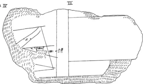
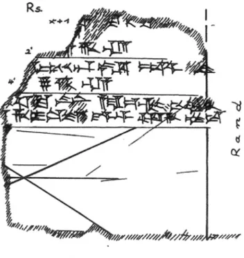
(Figure 1). Although the left side of this drawing is broken, studies on bird oracles suggest that the line crosscutting the field horizontally in the middle may be understood as a river or road (Beal 2002: 65–73, Sakuma 2009, 2: 84–85). Sakuma (2009, 1: 360) suggests that the three Winkelhaken may be the birds in flight. A similar, simpler drawing is found on KBo 41.141 (Figure 2).47Lastly, we find a sketch at the side of KUB 7.25 (Figure 3), a tablet of the festival of Sarissa (CTH 636), which seems to represent the town Sarissa with its four gates, the huwaši sanctuary, a mountain, and possibly some agricultural fields (Mielke 2017: 19–20). The representations of architectural space in Hittite art and in the iconography of Anatolian hieroglyphs, numerous clay liver models, and most importantly, clay architectural models and ‘tower-vessels’ may be seen as further evidence that the Hittites grasped the notion of realistic or stylised visual representations of body parts and architecture. Clay architectural models and ‘tower-vessels’ are of particular interest; these objects, though their proportions do not appear to be realistic, incorporated significant detail, such as wooden windows, protruding beams, or walls with crenellations, and were used as a source of information for the contemporary reconstruction of the fortifications
Figure 1: Technical illustration of an observation field for bird augury from the tablet KUB 49.60, with the kind permission of the author.
47 It is not certain if the drawing on KBo 41.141 also represents an observation field, since this tablet contains a liver oracle (van den Hout 2011: 56 n. 45).
walls of Hattusa.48These examples suggest that the scarcity of maps, plans, and sketches in Hittite Anatolia was not due to a complete ignorance of cartographic
Figure 2: Sketch of an observation field (?) from the tablet KBo 41.141, with the permission of the publisher.
Figure 3: Sketch on the side of KUB 7.25 representing Sarissa and its environs.
48 Hittite votive texts mention city models made of precious materials (Mielke 2011: 159, n. 13). For architectural models and‘tower-vessels’ see (Neve 2001 and Mielke 2018: 67–68, 71, 77).
notions or techniques, but may be because such representations did not survive in the archaeological record.49
5 Conclusions
In Hittite Anatolia, geographical information was produced and transmitted primarily, if not exclusively, for administrative and military purposes, and for the management of the state cult. Only a small percentage of geographical content from the Hittite archives concerns the world beyond Hatti and its vassal territories. It is difficult to say if scientific curiosity played any role as a motive for the production and transmission of geographical knowledge.
The acquisition, communication, and preservation of geographical informa-tion was an essential component of the efficient administrainforma-tion of the Hittite Empire. The evidence presented here allows us to glimpse into the processes through which geographical data was a) collected or produced by high ranking officials such as uriyanni, scribes, or scouts sent out into enemy territory, and b) transmitted in written, oral, and in some rare instances visual form, for diverse administrative purposes.50 There is no indication to suggest that officials who were involved in the collection or production of geographical knowledge belonged to a specialized professional class of“geographers.” There is, however, some evidence that such data was collected by officials through land surveys. KBo 62.5 (CTH 230), a document with geographical focus produced in an administrative context, may be seen as the report from such a survey. The preservation of geographical data for future reference might have been among the reasons for the continued transmission of certain documents in the Hattusa archives. We know, for instance, from the Bronze Tablet that Tudhaliya IV consulted the tablet of his father’s earlier treaty with Tarhuntassa while reorga-nizing the frontier territory between Hatti and Tarhuntassa (Bo 86/299 i 23–24). The acquisition and management of geographical knowledge was also cen-tral to the imperial programme to turn Hittite territory into the Hittite “home-land.” This was achieved by changing settlement patterns, building new cities, reshaping old ones, and taking over local places of significance and turning them into imperial monuments. Hittite rulers regularly travelled through the countryside with their consorts visiting sacred places, offering sacrifice,
49 It is possible, though impossible to prove, that visual representations of geographcial information were recorded on wax tablets.
50 Cf. Lorenz’ (2017: 322–23) brief account of how geographical information was managed by the Hittite polity.
celebrating festivals. They reorganised local cults across central Anatolia, incor-porating them into an imperial state-cult—a process that had intensified in the later Empire Period. To conclude, geographical knowledge was effectively used by Hittite rulers to weave together an imperial narrative of cultural homogeneity and interconnectedness to hold together a geography that was essentially heterogeneous.
References
Archi, Alfonso. 1979. L’humanité des Hittites. Pp. 38–48 in Florilegium Anatolicum. Mélanges offerts à Emmanuel Laroch. Paris: Éditions E. de Boccard.
Beal, Richard H. 2002. Hittite Oracles. Pp. 57–81 in Magic and Divination in the Ancient World, ed. Leda Ciraolo and Jonathan Seidel. Leiden: Brill.
————. 2011. Hittite Anatolia: A Political History. Pp. 579–603 in The Oxford Handbook of Ancient Anatolia, ed. Sharon R. Steadman and Gregory McMahon. Oxford: Oxford University Press.
Beckman, Gary M. 1988. Herding and Herdsmen in Hittite Culture. Pp. 33–34 in Documentum Asiae Minoris Antiquae. Festschrift für Heinrich Otten zum 75. Geburtstag, ed. Erich Neu and Christel Rüster. Wiesbaden: Otto Harrassowitz.
————. 1999a. The City and the Country in Hatti. Pp. 161–69 in Landwirtschaft im Alten Orient. Ausgewählte Vorträge der XLI. Rencontre Assyriologique Internationale, Berlin, 4.-8.7.1994, ed. Horst Klengel and Johannes Regner. CRRAI 41. Berlin: D. Reimer.
————. 1999b. Hittite Diplomatic Texts, 2nd. Atlanta: Scholars Press.
————. 2013a. Hittite Religion. Pp. 84–101 in The Cambridge History of Religions in the Ancient World, Vol. 1, ed. Michele Renee Salzman and Marvin A. Sweeney. Cambridge: Cambridge University Press.
————. 2013b. Foreigners in the Ancient Near East. Journal of the American Oriental Society 133: 203–215.
Bilgin, R. Tayfun. 2015. Bureaucracy and Bureaucratic Change in Hittite Administration. Unpublished PhD Dissertation.
Cohen, Yoram. 2001. The Image of the“Other” and Hittite Historiography. Pp. 113–29 in Historiography in the Cuneiform World, ed. Tzvi Abusch et al. CRRAI 45. Bethesda: CDL Press.
Collins, Billie Jean. 2007. The Hittites and their World. Atlanta: Society of Biblical Literature. Forlanini, Massimo. 2000. Pp. 9–19 in Landscapes: Territories, Frontiers and Horizons in the
Ancient Near East, ed. Lucio Milano et al. CRRAI 44/2. Padova: Sargon.
Freu, Jacques. 2005. Les‘barbares’ gasgas et le royaume hittite. Pp. 61–99 in Barbares et civilisés dans l’antiquité. Paris: L’Harmattan.
Gander, Max. 2011. Die geographischen Beziehungen der Lukka-Länder. THeth 27. Heidelberg: Universitätsverlag Winter.
Gerçek, N.İlgi. 2017. “The Knees of the Storm-god”: Aspects of the Administration and Socio-Political Dynamics ofḪatti’s Frontiers. Pp. 123–36 in Places and Spaces in Hittite Anatolia: Hatti and the East, ed. Metin Alparslan.İstanbul: Türk Eskiçağ Bilimleri Enstitüsü.
Gilan, Amir. 2015. Formen und Inhalte althethitischer Literatur. THeth 29. Heidelberg: Universitätsverlag Winter.
Haas, Volkert. 1993. Eine hethitische Weltreichsidee: Betrachtungen zum historischen Bewusstsein und politischen Denken in althethitischer Zeit. Pp. 135–44 in Anfänge poli-tischen Denkens in der Antike: Die nahöstlischen Kulturen und die Griechen, ed. Kurt A. Raaflaub. München: R. Oldenbourg Verlag.
————. 1994. Geschichte der hethitischen Religion. Leiden: Brill.
————. 2006. Die Hethitische Literatur: Texte, Stilistik, Motive. Berlin: De Gruyter. Harley, John Brian and David Woodward. 1987. Preface. Pp. xv–xxi in The History of
Cartography: Cartography in Prehistoric, Ancient, and Medieval Europe and the
Mediterranean, Vol. 1, ed. John Brian Harley and David Woodward. Chicago: The University of Chicago Press.
Harmanşah, Ömür (ed.) 2014. Of Rocks and Water: Towards and Archaeology of Place. Oxford: Oxbow Books.
Harmanşah, Ömür. 2015. Place, Memory, and Healing: An Archaeology of Anatolian Rock Monuments. London: Routledge.
Hoffner, Harry A. 1967. Review of Die Kaškäer: Ein Beitrag zur Ethnographie des alten Kleinasiens by Einar von Schuler. Journal of the American Oriental Society 87: 179–185. ————. 1980. History and Historians of the Ancient Near East: The Hittites. Orientalia 49:
283–332.
————. 1997. The Laws of the Hittites: A Critical Edition. Leiden: Brill.
————. 2001. Historiographie als Paradigma. Die Quellen zur hethitischen Geschichte und ihre Deutung. Pp. 272–291 in Akten des IV. Internationalen Kongresses für Hethitologie, Würzburg, 4.-8. Oktober 1999. StBot 45. Wiesbaden: Harrassowitz Verlag.
————. 2009. Letters from the Hittite Kingdom. Atlanta: Society of Biblical Literature. Hutter, Manfred. 2014. Grenzziehung und Raumbeherschung in der hethitischen Religion.
Pp. 135–52, in Raumkonzeptionen in antiken Religionen. Beiträge des internationalen Symposiums in Göttingen, 28. und 29. Juni 2012, ed. Rezania, Kianoosh. PHILIPPIKA 69. Weisbaden: Harrassowitz Verlag.
Kitchen, Kenneth A. and Paul J. N. Lawrence. 2012. Treaty, Law and Covenant in the Ancient Near East. Part 3: Overall Historical Survey. Wiesbaden: Harrassowitz Verlag.
Klinger, Jörg. 1992. Fremde und Außenseiter inḪatti. Pp. 187–212 in Außenseiter und Randgruppen: Beiträge zu einer Sozialgeschichte des Alten Orients, ed. Volkert Haas. Xenia 32. Konstanz: Universitätsverlag Konstanz.
————. 2001. Historiographie als Paradigma. Die Quellen zur hethitischen Geschichte und ihre Deutung. Pp. 272–91, in Akten des IV. Internationalen Kongresses für Hethitologie, Würzburg, 4.–8. Oktober 1999. StBot 45. Wiesbaden: Harrassowitz Verlag.
Klock-Fontanille, Isabelle. 2002. A propos du rituel d’évocation a la frontiere ennemie (CTH 422): les rituels comme construction ideologique. Pp. 59–79 in Rites et Célébrations. Cahiers KUBABA 2. Paris: L’Harmattan.
Klock-Fontanille, Isabelle, Séverine Biettlot, and Karine Meshoub. 2010. Avant-propos. Pp. 9–17 in Identité et altérité culturelles: Le cas des Hittites dans le Proche-Orient ancien. Actes de colloque, Université de Limoges 27–28 novembre 2008, ed. Isabelle Klock-Fontanille et al. Bruxelles: Éditions Safran.
Kloekhorst, Alwin. 2008. Etymological Dictionary of the Hittite Inherited Lexicon. Leiden: Brill. Kryszeń, Adam. 2016. A Historical Geography of the Hittite Heartland. AOAT 437. Münster:
Liverani, Mario. 2001. International Relations in the Ancient Near East, 1600–1100 B.C. New York: Palgrave.
Lorenz, Jürgen. 2017. Moving through the Hittite Landscape in Hittite Texts. Pp. 319–23 in Hittite Landscape and Geography, ed. Mark Weeden and Lee Z. Ullmann. Leiden: Brill.
Lorenz, Jürgen and Elizabeth Rieken. 2007.“Auf dem Weg der Stadt Šāššūna … ”. Pp. 467–86 in Tabularia Hethaeorum: Hethitologische Beiträge. Silvin Košak zum 65. Geburtstag, ed. Detlev Groddek and Marina Zorman. Wiesbaden: Harrassowitz Verlag.
Mielke, Dirk Paul. 2011. Hittite Cities: Looking for a Concept. Pp. 153–94 in Insights into Hittite History and Archaeology, ed. Hermann Genz and Dirk Paul Mielke. Colloquia Antiqua 2. Leuven: Peeters.
————. 2017. Hittite Settlement Policy. Pp. 13–27 in Places and Spaces in Hittite Anatolia: Hatti and the East, ed. Metin Alparslan.İstanbul: Türk Eskiçağ Bilimleri Enstitüsü.
————. 2018. Hittite Fortifications between Function and Symbolism. Pp. 63–81, in Understanding Ancient Fortifications: Between Regionality and Connectivity, ed. Ariane Ballmer et al. Oxford and Philadelphia: Oxbow.
Millard, Alan R. 1987. Cartography in the Ancient Near East. Pp. 107–16 in The History of Cartography: Cartography in Prehistoric, Ancient, and Medieval Europe and the
Mediterranean, Vol. 1, ed. John Brian Harley and David Woodward. Chicago: The University of Chicago Press.
Neve, Peter. 2001. Hethitische Architekturdarstellungen und -modelle aus Boğazköy-Hattusha und ihr Bezug zur realen hethitischen Architektur. Pp. 285–301 in ‘Maquettes architec-turales’ de l’Antiquité. Regards croisés (Proche-Orient, Égypte, Chypre, bassin égéen et Grèce, du Néolithique à l’époque hellénistique). Actes du Colloque de Strasbourg, 3–5 décembre 1998, ed. B. Muller. Strasbourg, Paris: Boccard.
Nougayrol, Jean. 1955. Les Palais Royal d’Ugarit IV. Paris: Imprimerie Nationale, Librairies C. Klincksieck.
————. 1956. Les Palais Royal d’Ugarit IV. Paris: Imprimerie Nationale, Librairies C. Klincksieck.
Puhvel, Jaan. 1984. Hittite Etymological Dictionary, Vol. 1: Words Beginning with A. Berlin: Mouton Publishers.
Rüster, Christel and Gernot Wilhelm. 2012. Landschenkungsurkunden hethitischer Könige. StBoT Beih. 4. Wiesbaden: Harrassowitz Verlag.
Sakuma, Yashuiko. 2009. Hethitische Vogelorakeltexte. Teil 1: Untersuchung, Teil 2: Bearbeitung. Unpublished PhD Dissertation.
Schwemer, Daniel. 2008. Fremde Götter inḪatti: Die hethitische Religion im Spannungsfeld von Synkretismus und Abgrenzung. Pp. 137–57 in Ḫattuša-Boğazköy: Das Hethitterreich im Spannungsfeld des Alten Orients. 6. Internationales Colloquium der Deutschen Orient-Gesellschaft 22.–24. März 2006, Würzburg, ed. Gernot Wilhelm. CDOG 6. Wiesbaden: Harrassowitz Verlag.
Singer, Itamar. 1981. Hittites and Hattians in Anatolia at the Beginning of the Second Millennium. B.C. JIES 9: 119–134.
————. 1994. “The Thousand Gods of Hatti”: The Limits of an Expanding Pantheon. Pp. 81–102 in Concepts of the Other in Near Eastern Religions, ed. Ilai Alon et al. IOS 14. Leiden: Brill. ————. 2002. Hittite Prayers. Atlanta, Georgia: Society of Biblical Literature.
————. 2011. The Calm Before the Storm: Selected Writings of Itamar Singer on the Late Bronze Age in Anatolia and the Levant. Atlanta: Society of Biblical Literature.
Süel, Aygül. 2005. Ortaköy Tabletlerinde Geçen Bazı Yeni Coğrafya İsimleri. Pp. 679–85 in V. Uluslararası Hititoloji Kongresi Bildirileri, Çorum 02-08 Eylül 2002. Ankara.
Ullmann, Lee Z. 2010. Movement and the Making of Place in the Hittite Landscape. Unpublished Ph.D. Dissertation.
Ullmann, Lee Z. 2014. The Significance of Place: Rethinking Hittite Rock Reliefs in Relation to the Topography of the Land of Hatti. Pp. 101–27 in Of Rocks and Water: Towards and Archaeology of Place, ed. Ömür Harmanşah. Oxford: Oxbow Books.
Van Den Hout, Theo P.J. 2011. The Written Legacy of the Hittites. Pp. 47–84 in Insights into Hittite History and Archaeology, ed. Hermann Genz and Dirk Paul Mielke. Colloquia Antiqua 2. Leuven: Peeters.
Von Schuler, Einar. 1965. Die Kaškäer: Ein Beitrag zur Ethnographie des alten Kleinasiens. Berlin: De Gruyter.
Weeden, Mark. 2011. Hittite Logograms and Hittite Scholarship. StBoT 54. Wiesbaden: Harrassowitz Verlag.
Weeden, Mark and Lee Z. Ullmann. 2017. Introduction. Pp. 5–14 in Hittite Landscape and Geography, ed. Mark Weeden and Lee Z. Ullmann. Leiden: Brill.