11
[ �
��:
.
unııecı
Nttlons • UNESCOChair in Cultural Oiplomaey.
E<lıcotionol-and • -.ncoandEduc:otıon
Culuol � : IStffl>ul Ayıff, Un-. T\mıy
CULTURAL LANDSCAPE
OF VAN-TURKEY
Editors: Dr. Gökçen Firdevs Yücel Caymaz, Prof.Dr. Bilge Işık Associate editor: Assoc.Prof.Dr. Esen Gökçe Özdamar
English redaction: Research assistant Tuğba Tok Date of Publishing: October 2018
E-ISBN: 978-975-2438-33-0 Referee Board:
Prof.Dr. Zülküf Güneli/İstanbul Aydın University, Department of Architecture Prof.Dr. Müge Akkar Ercan/Middle East Technical University, Department of Urban and Regional Planning
Assoc.Prof.Dr. Mücahit Yıldırım / Dicle University, Department of Architecture Assoc.Prof.Dr. Hatice Ayataç/İstanbul Technical University, Department of Urban and Regional Planning
Preface
1 RURAL SETTLEMENT PATTERN AND STRUCTURAL
CHARACTERISTICS IN THE ERÇEK BASIN OF VAN
Alev Erarslan
5
2 INFLUENCES OF 2011 ERCİŞ EARTHQUAKE ON RURAL
HOUSING IN VAN
Caner Göçer
18
3 RESTORATION PROCESS OF CHURCH OF THE HOLY
PILGRIMAGE-AGHTAMAR IN VAN Fatma Sedes
28
4 AN EVALUATION ON VAN RURAL SETTLEMENTS IN THE
CONTEXT OF LEGAL AND REGULATORY FRAMEWORK
Gülhan Benli
40
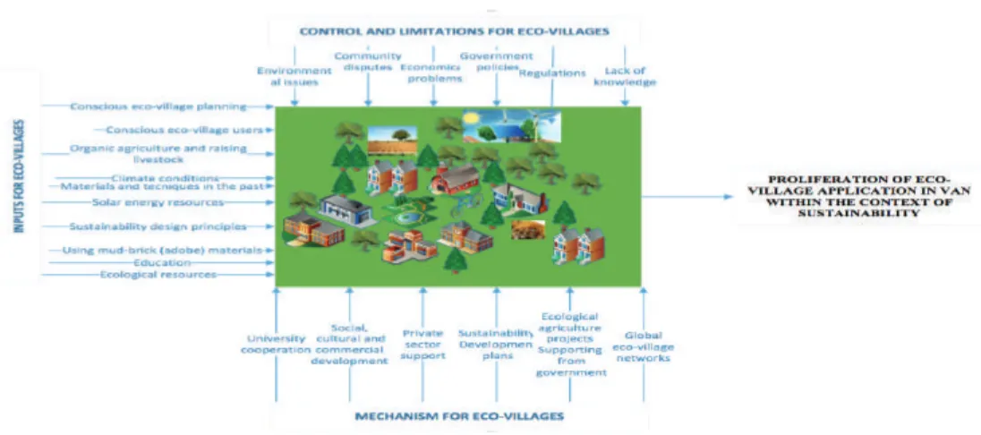
5 PROLIFERATION OF THE ECO-VILLAGE IN VAN WITHIN
THE CONTEXT OF SUSTAINABILITY
Pelin Karaçar
54
6 MADRASAS AS EDUCATIONAL BUILDINGS IN VAN
Seyhan Yardımlı
76
7 “POLAT YÖRÜKOĞLU HOUSE”, AN EXAMPLE OF THE VAN TRADITIONAL CIVIL DOMESTIC ARCHITECTURE
Şahabettin Öztürk
8 DEVELOPMENT OF THE COMPARATIVE RISK ANALYSIS WITH FUZZY MODEL APPROACH FOR SUSTAINABLE RURAL DEVELOPMENT: THE EXAMPLE OF VAN
Ufuk Fatih Küçükali
114
9 EDREMIT “MAIDEN’S CASTLE CHURCH, CHRISTIAN
CEMETERY” CONSERVATION PLANNING APPROACH
Emine Ekinci Dağtekin, Vahap Karakaya
132
10 ASSESSING THE LONG TERM PERIODIC URBAN LAND
USE DEVELOPMENT OF VAN BY REMOTE SENSING
Onur Şatır, Pınar Bostan, Okan Yeler, Şevket Alp
151
11 WHAT HAPPENED TO TRADITIONAL VAN GARDENS?..
Şevket Alp
160
12 LIVELINESS PATTERN OF VAN CITY CENTRE (BAZAAR) FROM THE VIEWPOINT OF FLÂNEUR/FLÂNEUSE: SPATIAL TOPOLOGY OF TWO MAIN AXES WITH OPEN AND GREEN AREAS
Yasemin İlkay
168
13 ROLE OF CLIMATIC FACTORS IN THE FORMATION OF ARCHITECTURAL IDENTITY IN RURAL AREAS: THE CASE OF THE DISTRICTS OF ÇALDIRAN AND ÖZALP IN THE PROVIENCE OF VAN
Şefika Ergin
Preface
Silk Road was a trade route in the history starting from China going to Europe, by the second century BC to the end of the fourteenth century AD. Silk was the major trade product that was carried by caravan on this road, interaction the socio-economy and culture and community.
By the time efficiency of the silk dropped-off by the industry of syntactic fibber, but the “silk road” can be revived as significant route of “Science Road” and of “other products”.
At the east border of Turkey, city VAN is also on the silk road. The slow interaction in the nature and social life can be followed by Cultural Landscape.
This work examines the most up-to-date information on Cultural Landscape at the VAN era to exchange, disseminate and to share the material.
The key-words of the book “CULTURAL LANDSCAPE OF VAN-TURKEY” are as: Regional history, climatic factors, citizen values, city bazaar, gardens, urban land, castle, church, rural development, domestic architecture, education buildings, eco-village, earthquake influence, structural characteristics.
CHAPTER NUMBER 1
RURAL SETTLEMENT PATTERN AND
STRUCTURAL CHARACTERISTICS IN THE ERÇEK
BASIN OF VAN
ALEV ERARSLAN
Rural settlement and rural architecture researches in Anatolia date back to the recent past. Many different rural settlement regions and housing culture that changes as per the region determined by different climate, geography, culture, traditions, and social needs are available in Anatolia. Rural settlements are the settlement units whose economy is based on agriculture and animal breeding, have distinctive and homogenous social relations, where the population is low, which have certain settlement border. Rural settlement types are con-tinuous and temporary settlement types which are called as village and sub-village settle-ments which are smaller than the village. Aggregation of rural settlement structures togeth-er also forms settlement textures such as collective, distributed, stogeth-eries, group, etc. Yet, the rural house is the most important living area in rural settlements. Rural house is described as a structure produced under the traditions of a certain region depending on historical, geographical, economic and social factors. Regarding the determination of the type of a rural house, various social, cultural and economic factors, notably climate and topography also play an important role.
This study is carried out in the villages Karagündüz, Ilıkaynak, Dereüstü (Anzaf), Gölyazı, Aşağıgölalan, Yukarıgölalan, Kozluca, Aşağıçitli, Irgat, Aktaş, Erçek mahallesi, Yalınağaç, Bak-latepe, Çomaklı and Gedelova located through coast of the Lake Erçek Basin, Van Province. Objective of this study is to establish settlement characteristics in the region and to reveal the rural architectural house plan types, dominant settlement type of the region and to explain the factors which are effective in the formation of these plans.
I. Introduction
Settlement is a concept that covers the environment created by humans. Rural settle-ments are the settlement units whose economy is based on agriculture and animal breed-ing, which have homogenous social relations peculiar to themselves, the population is low, possess certain settlement border. Rural settlement types are the continuous (farm, sofa, arable field, neighbourhood) and the temporary (plateau, large nomad tent, kom, fold) ones which are called as village and sub-village settlements smaller than village. Combination of rural settlement structures also forms settlement patterns such as collective, distributed, series, group, etc. (Selvi 2011, 25).
People have been affected from natural environmental conditions during palaeolith-ic ages; landforms, climate conditions and vegetation have been of great importance for them (Sütgibi 2008, 62).First settlements have been established in overflow areas of large streams, plateau plane and valley grooves having fertile soils depending on water and fertile soil characteristics (Sütgibi 2008, 63).
Rural settlements emerge in various regions under different circumstances. Different ecological and geographical niches result in the exhibition of diversified settlement models. Environmental factors take the lead in the selection of rural settlement areas. The most important factors that influence rural settlements are topography, climate, flora and fauna; these factors constitute the natural habitats.
2. Topography
Topography is one of the essential factors that determine the settlement type. Topo-graphic characteristics, as one of the most significant example of the relationship between human and nature, have direct or indirect effects on the distribution, population and eco-nomic activities of settlements. Since the first ages, the proximity to freshwater bodies such as stream, lake and river have become main criteria for selection of a place to settle for human beings. Rural settlements are divided into two as collective and distributed ones as per the characteristics of land structure and water resources. These settlements show differences throughout valley, in-canyon, hill and stream according to topography.
The relation of the inclination and the elevation with the population density is explicit in land use. While the amount of population and settlements is low in mountainous and rugged lands, these numbers are high in plain lowlands. As no drought is felt on mountainous lands, the streams fed from snowmelt are available; therefore, they have their own ecosystem fields. These
As an example of relation of topography and settlement, in rugged topographic lands split by streams, limited and distributed structure of arable lands give rise to emergence of dispersed settlements. Mountain settlements display an aggregation which is dispersed and disconnected from each other. However, these aggregations have a structure whose pattern is dense within its body. Access difficulty makes protection of original structures of these settlements easier. The common point that make plains attractive for settlements are fertile lands and existence of water supply. In general, settlements develop at shores of plains towards hillsides in order to evaluate agricultural land because plains have valuable soil (Selvi 2011, 27).
3. Climate
One of the elements of natural environment that have an impact on rural settlements is the climate. According to altitude difference, the climate elements such as the wind, rain-fall, and temperature show some alterations. In places where effects of climate elements are maximum, inhabitation is rarely seen. In plain lands where rainfall and water is low, collective settlements whose structures are close to each other are seen. In humid climate regions where rainfall is abundant, dispersed settlement types including field, vineyard and garden areas are observed. The reason why the selection of valley lands is that they are sheltered against climate conditions. Temperature values are also important for determin-ing the vegetation period, which is important for livestock activities. Various climate regions differentiating from each other have direct impact on settlement and architecture such as local topography. Among the effects of climate on physical environment; topography, type of soil, vegetation, stream flow rate and regimes, lake formation, salinity ratios of seas may be sorted (Tunçdilek 1986).
4. Flora and Fauna
The presence of climate-friendly vegetation and animal communities is vital for the sur-vival of human life. Places where nutritional needs can be obtained more easily play role in selection of settlement places. The presence of rich flora makes conditions favorable for animal communities which survive thanks to this vegetation, this leads to emergence of very diversified and rich animal communities as well. People of Neolithic Age settled in the lands suitable for agriculture, grew wild grains and cultivated them. Rich grasslands and pas-tures as well as water resources are important for animal breeding. Abundancy of flora in the region has improved cattle and sheep breeding. High altitude, rich water resources and abundance of mountain meadows and pastures turns district into very convenient plateau environment. The richness of tree species is also important in terms of meeting the need to build house’s door and roof and the need for fuel in winter (Tunçdilek 1986).
5. Rural Houses
The living space of the rural settlements is the housing structures. Rural house can be defined as a structure produced under traditions of a certain region depending on historical, geographical, economic and social factors. In determining rural house type; social, cultural and economic factors as well as environmental/physical ones, notably climate and topogra-phy also play important role (Tunçdilek 1967).
Climate is a key factor in formation of housing. Architecturally, climate has an impact on the direction and orientation of building, in terms of material, construction technique, dimensions of building, splitting rooms, façade characteristics, dimensions and locations of doors and windows, roof and open- closed spaces (Yakar 2000, 145).
Another physical factor efficient in rural house formation is also topography. In the for-mation of house forms; the boundaries of the land and inclination play a role. Topography designates the direction of houses. For instance, houses are settled towards the north in general because of the scene provided by the roughness of Black Sea region (Gür 2005, 67). Topography becomes effective on building material. While stone, adobe and wood are used in alluvial plains, the material in high altitude is stone or wood (Yakar 2000, 145).
While worldview, cultural values, family, relatives, society relationships and life style are listed among cultural factors; social factors are demographic structure, socio-economic structure of family, family structure and life style (Gür 2005, 165). Rapoport has suggest-ed concepts “peculiar to culture” and “cultural values and selections” for rural house de-sign (Bretonne 1979, 116). According to Rapoport, buildings, especially houses are not only physical products but also cultural products.
Lifestyle shows different features in each culture. As each community has its own at-titudes and traditions, this expectation also determines the architectural structure (Selvi 2011, 19). The place of family in society, the habits of daily life, confidentiality (privacy) of family life also affect the design of the house. Religious belief is also another social symbol in shaping of rural dwelling. Religion studied within the scope of socio-economic factors affect-ing house design is a phenomenon that regulates and influence human relations. Rapoport has mentioned that religion is a factor that has impact on environment and people (Rapo-port 2004). Gender segregation based on religious traditions affects the space.
In general, rural settlements are places where large family type is enable to maintain their culture. Therefore, concept of large family is a significant factor in the establishment and the shaping of the structure in rural settlements. Large families live in larger houses because they tend to live and work together. Social bond in rural settlements is also based
Another determinant parameter of rural house is economic organization of householder. Some changes in structure determine the identity of the user. The size of house reflects economy-production relationship. The housing structures of the region where economic model whose main income source is shepherding is dominant differs from those of the set-tlements established on agriculture based economy [5: 145]. Farming families have larger living areas than average houses, as they have space for storage and additional activities (Yakar 2000, 146).
Another social element related to the housing culture is the building tradition. The ar-chitectural cultures that exist in the historical memory of the regions are transferred to the generations as heritage. Rural architecture has originated as a result of cultural continuity. Traditional rural architecture is less influenced from rapid cultural changes. Rapoport men-tions that traditional houses has made it possible to maintain the social habits more easi-ly. It usually reflects thousand of years of accumulation and tradition. The less influenced and hardly changing characteristics of rural settlements increases this effect. Even though structure material and construction technique evolve in time, it is known that plan types are affected less. This can be observed in a region where the plan of a structure is historical while it has been built with the current material and construction system. Despite changing user requirements over time, original identity belonging to each region and culture forms as a result of continuity and architecture in plan types. Newcomer communities in a region, especially those with a nomadic social life, adopt the architectural tradition in that area when it comes to turning a settled life. Despite ethno-cultural diversity, they adapt to the tradition of materials and structures that are appropriate for that particular topography and physical environment.
6. Settlement Characteristics In The Lake Erçek Basin
The Lake Erçek has an area of around 106.2 km² at 30 km. east of The Lake Van Basin at 1803 m. altitude. The region forms a separate closed basin within the Lake Van’s closed basin. The basin involves some sections of Van Centre and Van Özalp, Saray and Gürpınar districts administratively. The main stream flowing into the lake is Memedik Stream that rise from Iran border and joins in the Lake Erdek from the east and Irgat Stream that joins it from the south. Other basic streams in the region are Karasu Streamlet and Değirmendere. Apart from The Lake Erçek; the Lake Gövelek, the Dam Lake Sarımehmet and the Lake Bostaniçi fall within analysis area (Duman and Çiçek 2011, 170; Duman and Çiçek 2012, 247). The lake is surrounded with the ridges extending from the south to the west. Out of these, Mount Ahte the closest point to the lake is at the highest point with 2864 m. Other important ridg-es are Ziyaret Hill (2793 m.), Şehitmirza Hill (2796 m.), Gündüz Hill (2840 m.) at the east; Seyhhasan Hill (2616 m.) at the southeast, Mount Kazan (2860 m.), Kızkalesi Hill (2714 m.), Boztepe (2717 m.) at the south; Zozan Hill (2729 m.), Bireş Tepe (2704 m.), Seyan Hill (2636 m.) and Karataş Hill (2690 m.) at the north (Duman and Çiçek 2011, 170). Plains exist around immediate vicinity of the Lake Erçel, based plain and straits are also found.
The Van region is a high and remote region from the sea with an average altitude of 2000 m. The Lake Van at 1646 m. height forms the minimum-altitude section of the region. In the region whose annual temperature average is 9 oC, the summer is cold and the winter is hot. Average temperature of January, the coldest month of the year is -3.5 °C. Maximum tem-perature in August, the hottest month is 28.1 ºC. The plains positioned on the shore of the lake constitute lands suitable for settlement and agriculture in terms of climate (Kalelioğlu 1991, 156). Prevailing wind in the locality is levanter. The wind which is blown from the east is called as “Persian Wind”. The winds with western sector are encountered at second de-gree. Annual average rainfall amount of the region is 385.0 and 498.8 mm (Kalelioğlu 1991, 161; Duman 2011, 172).
Village is dominant settlement type in the region (Figure 1). 50 village settlements are available in the basin. Firstly, physical features such as topography, climate conditions, soil characteristics and water resources have affected settlement places of village settlements in the basin. The villages in the basin are classified under two groups in terms of their geo-graphical properties according to their locations and altitude steps. The villages within the basin have generally altitude between 1800- 2250 m. The number of the village higher than 2250 m. is low (Yılmaz 2014, 300). The villages at completely high altitude are settled mostly in mountain foots and plains due to water resources, easy access and proximity to agricul-tural lands rather than bottom of the basin. Number of settlement established in mountain foots is dominant in number. The villages here benefit from the pasture ground in mountain-ous area and the agricultural lands on the plain (İzbırak 1951, 109).
Fig. 1-1. Settlement Examples in the Lake Erçek Basin a) Valley Site, Anzaf b) Yamaç Village
Yukarıgölalan c) Plain site, Aşağı Gölalan
A very small part of the basin villages are established on the mountainous land and ridg-es that climate and transport conditions become harsh and soil productivity drops. In thridg-ese settlements founded on inclined surfaces; grassland and pasture lands cover much space (Yılmaz 2014, 305). In the basin that is quite high compared to Turkey’s average, number of village settlement reduces following 2251 m. because of inconvenience of climate and topography conditions. Changes in temperature conditions has restricted agricultural ac-tivities in this area, livestock acac-tivities have become the main source of income for the few villages that have been established in this land.
In addition to environmental factors, human factors such as agriculture and livestock activities and means of transport have also been taken into consideration in place selection of the Lake Erçek Basins villages. The economy of the villages within the basin is based on agriculture and animal husbandry.
The population of Erçek, the most populated village, is 3649 persons according to the results of census 2012 (URL 1). The smallest village in the region is Kozluca village. Again, as per the results of census 2012, total 44749 person- population is available in 50 villages within the Lake Erçek Basin (Yılmaz 2014, 309).
7. Architectural Properties Of Van Lake Basin
This study was carried out in Karagündüz, Ilıkaynak, Dereüstü (Anzaf), Gölyazı, Aşağıgölalan, Yukarıgölalan, Kozluca, Aşağıçitli, Irgat, Aktaş, Erçek mahallesi, Yalınağaç, Bak-latepe, Çomaklı and Gedelova villages located on the coast of the Lake Erçek Basin (Figure 1-2).
Fig. 1-2. Analysed villages (Yılmaz 2014, Map 3)
In house structures of the region, five basic plan types; without sofa, the outer sofa, the inner sofa, with tandır room are used;
1) The plan without sofa: The first plan to be used in the region is the type of plan that is
found in few examples and is called “without sofa”.. This plan scheme utilized at limited number of structures in the region consists of two rooms of which one is horizontal and another is vertical and the space in front of these rooms, whose top is open (Figure 1-3). At these structures designed as single storey, the space whose top is open is a front of a house; its boundaries are determined by dimensions of rooms. This space is transition area between indoor and outdoor, a circulation area providing connection between rooms.
Fig. 1-3. The plan without sofa. Dereüstü Village
2) The outer sofa plan: Another plan type employed in the region’s houses are the plan
known as “outer sofa”. House structures with outer sofa found in the region are constructed according to “the outer sofa surrounded with two way room line” type (Eldem 1955, 84-85).
This type of sofa is surrounded by chambers perpendicular to each other in two direc-tions. The main planimetris of the plan are two consecutive rectangles of equal width, with the main axes parallel to the façade. The leading sofa is an open portico, sometimes with wooden columns. The back room behind is the main room (Figure 1-4). In a wing of a hall there are two rooms, sometimes a single room and sometimes a sofa and a parallel main room on the back. Sofa is reached by a staircase.
3) The inner sofa plan: The most commonly used plan in the area housing is the type of plan
called “inner sofa”. In this plan, the sofa is the inner section, a line with rooms that facing each other is available for each two wings. For the inner sofa plan within the region, the rectangular sofa is taken at the centre of house, surrounded with one row of rooms through-out its two long wings. House is reached from the door at the centre of the sofa looking at façade. The sofa retreated to form an entrance area (portico) which has the same width with sofa; covered, with or without wooden columns. In this type of area, two-room, three-room and four-room inner sofa type; used in three different variants. (Figure 1-5).
Fig. 1-5. The inner sofa with 2 rooms. Kozluca Village
4) The Inner Sofa with tandır room: In this type of house with a small number of examples
in the district, a house built according to the two-room inner sofa plan, behind the sofa, a room with a horizontal rectangular shape with the house tandır room is located. (Figure 1-6). A courtyard is located in front of the tandır room. In this building type that one of side rooms on one wing of the sofa is extended forward, there is a wooden columned porch in front of the structure.
5) The complex plan type: This type of structure found in several houses in the region
con-sists of combining external and internal sofa type. The front of the building was made in the form of a single room standing upright on the sofa’s wing, an application of the outer sofa type in the district. However, a new room is added near this single room this time. Back part of the structure is constructed according to the inner sofa with two rooms type (Figure 1-7).
Fig. 1-7. The complex plan type. Yukarıgölalan Village
Local houses are settled in the direction of north-south. Entrances face the south. Struc-tures have generally single storey, raised over the stone basement. In the case of a small number of two-storey buildings, the lower floor is used as a barn, warehouse, cellar or hay-stack. The sofas/porch raising over basement are accessed via steps. Basement and steps are walled with stones whilst gaps are filled with small stones. Mortar is used sometimes. Construction material used in the walls of structure is adobe. Walls are plastered in some instances. Wood is only used as lintel in order to strengthen adobe wall in upper and lower parts of window (Figures 1-6, 1-11, 1-12). In some repairs at structures, it is seen briquette tile is used. In general, flat roof is dominant in region’s houses; hipped roof samples are also available in limited number as well.
In the rooms there are windows on both the front and side façades. It is observed that attention is paid to symmetry concern for the number of windows. In inner sofa type, there is a triple façade organization consisting of room-porch-room order (Figures 1-8, 1-12, 1-15).
A part of structural design of inner and outer sofa type is porch columned/columnless space that extends before rooms. This space is called with the names such as “balcony, lad-der, döşk, tence, pilekan” etc. in the district. However, most widely usage for this area in the region is the word “balcony”. Main room of house is called as “saloon”.
in a corner of a room of the house is used as bathing area. Outside of the structures, there are different functional spaces such as a tandır house, cellar, stables, stables, haystacks and banisters which are used as kitchens.
It is seen that environmental factors such as climate and topography and the cultural factors are efficient in plan selection of the region’s houses. “The inner sofa plan”, the most prevalent plan implemented in the region’s houses shows compatibility with climate condi-tions. The harsh continental climate of the region necessitates the use of the sofa indoors. “The outer sofa” type, another plan type in the region is a semi-closed space whose sofa is wooden columned porch that extends in front of rooms. Plan type without sofa which is found in a small number of examples at limited number in the region’s houses is a less pre-ferred plan template due to climate conditions.
Another factor in configuration of the region’s houses is structure tradition which is an important cultural parameter. The architectural cultures that exist in the historical memory of the regions are passed on to the generations as inherited legacies(Rapoport 2004). In the vernacular housing, there are traces of Urartu and its close neighbors from Hittite residen-tial architecture in terms of plan, construction systems and building materials.
8. Conclusion
Van region is one of the most important regions that incorporates rural architecture and cultural heritage patterns of Anatolia. The rural settlement features of the region and local architectural examples have important characteristics in terms of rural settlement charac-teristics of Anatolia with their unique characcharac-teristics. In Erçek Lake basin, local settlement texture exhibited settlement examples suitable for physical conditions. The rural architec-ture of the region is the product of both material and plan types, as well as the environmen-tal conditions of the region as well as the result of the rich historical background.
REFERENCES
Bretonne, C., 1979. “An Interview with Amos Rapoport on Vernacular Architecture”, M. B.T.U. Journal of the Faculty of Architecture, Volume 5, Number 2 (1979): 113-126.
Duman, N., 2011. “Erçek Gölü Yakın Çevresinin Fiziki Coğrafyası”, Ankara Üniversitesi Sosyal Bi-limler Enstitüsü Coğrafya (Fiziki Coğrafya) Anabilim Dalı, Yayınlanmamış Doktora Tezi, Ankara.
Duman, Neşe, and Çiçek İhsan., 2011. “Erçek Gölü Yakın Çevresinin Jeomorfolojik Özellikleri”, E-Journal of New World Sciences Academy 2011, Vol. 6, Number 4: 169-188.
Duman, N., and Çiçek İ., 2012. “Erçek Gölü Havzası’nın Jeomorfolojisi ve Gölün Oluşumu”,
Uluslararası Sosyal Araştırmalar Dergisi, The Journal of International Social Research Cilt: 5, Sayı 20: 243-260.
Gür, Ş. Ö., 2005. The Eastern Black Sea Traditional House in Rural Architecture in the Eastern Black Sea Region [“Doğu Karadeniz Konutu”, Doğu Karadeniz’de Kırsal Mimari] Exhibition
Publ., Curator, Ameli Edgü, Milli Reassürans, 162-212.
İzbırak, R., 1951. Cilo Dağı ve Hakkari ile Van Gölü Çevresinde Coğrafya
Araştırmaları.Anka-ra: Anıl Matbaası.
Kalelioğlu, E., 1991. “Van Ovası’nın İklim Özellikleri”, Ankara Üniversitesi Dil ve Tarih-Coğraf-ya Fakültesi Dergisi, Cilt: 35 Sayı: 2: Sayfa: 155-166.
Rapoport, A., 2004. Kültür Mimarlık Tasarım (Çev., Batur, S.), Yapı Yayınları, Istanbul. Selvi, F., 2011. “Karaman Başyayla Konutlarının Mimari Özelliklerinin incelenmesi”, Selçuk
Üniversitesi Fen Bilimleri Enstitüsü, Yayınlanmamış Yüksek Lisans Tezi.
Sütgibi, S., 2008. “Türkiye’de Yerleşim Ekolojisi Üzerine Bazı Değerlendirmeler”, İzmir
Aege-an Geographical Journal, 17/1-2: 61-71, Izmir, Turkey.
Tunçdilek, N., 1986. Türkiye’de Yerleşmenin Evrimi, İ.Ü. Coğrafya Enstitüsü, İstanbul. Tunçdilek, N., 1967. Türkiye iskan coğrafyası (Kır iskanı). İ.Ü. Edebiyat Fakültesi Y.N. 1280,
İstanbul.
Yakar, J., 2000. Ethnoarchaeology of Anatolia: Rural Socio-economy in the Bronze and Iron
Yılmaz, M., 2014. “Erçek Gölü Havzası’ndaki Köy Yerleşmelerinin Coğrafi Özellikleri”, Ata-türk Üniversitesi Sosyal Bilimler Enstitüsü Dergisi 18 (1): 299-328.
URL 1. http://www.van.pol.tr/Sayfalar/VanTanitim/Tarih.aspx, last acessed on 04 December
2017.
Alev ERARSLAN, Assoc.Prof.Dr.,
Graduating from Istanbul University, Department of Asia Minor Languages and Cultures in 1991, she completed her master and doctorate degrees in Istanbul Technical University in Art History Program. She has written many national and international articles on Anatolian urban history, settlement systems and Anatolian rural architecture.
CHAPTER NUMBER 2
INFLUENCES OF 2011 ERCİŞ EARTHQUAKE ON
RURAL HOUSING IN VAN
CANER GÖÇER
The province of Van is located in the east of the North Anatolian fault line and is under the impact of a seismic belt that has been active for hundreds of years. The last earthquake in the region which has occurred on October 23, 2011 at 13:41 local time and of which moment magnitude value (Mw) changed between 7.1 and 7.3 according to different insti-tutions has caused a significant damage both in the central region of the province of Van and especially the district of Erciş and the villages in the vicinity. In this study the damages incurred by the rural residences made of adobe material as a result of the said earthquake have been examined and evaluated. The evaluations are based on observational structural examinations carried out in terms of the types and degrees of the damage. At the end of the study general evaluation of the earthquake impact of the structural properties of the adobe houses was made and proposals were summarized that would highlight the measures to be taken for the residences in our country which have properties similar to those of the resi-dences in the earthquake zone.
Keywords: Rural region of Van, earthquake damages, adobe, sustainability.
I. Introduction
There are three seismic belts in Turkey, namely North Anatolian, South-eastern Anato-lian and West AnatoAnato-lian seismic belts. There regions are under the impact of earthquakes
with differing magnitudes and destructiveness. The said earthquakes have posed a big threat in terms of the protection and sustainability of the architectural legacy in Anatolia for hundreds of years. The use of adobe and stone material in the construction of houses is wide spread in Anatolia in respect of economy, easiness of construction and providing the climatic conditions of comfort. Various improvements have been made within the frame-work of the local means and level of knowledge depending on the performance of these material against earthquake. The earthquake performance of the adobe and stone material has been developed to a great extent as a result of the scientific studies about the material and construction technology carried out in the recent years.
In this study the damages incurred by the rural residences made of adobe material which have been affected by the earthquake in Van in the year 2011 have been examined and eval-uated. The study comprises the villages of Karagündüz, Ilıkaynak, Dereüstü, (Anzaf), Gölyazı, Aşağıgölalan, Yukarıgölalan, Kozluca, Asağıçitli, Irgat, Aktas, Erçek Mahallesi, Yalınağaç, Bak-latepe, Çomaklı and Gedelova. The evaluations are based on the observational data depend-ing on the types and degrees of damage that has occurred. A general evaluation on the earthquake impact of the structural properties of the adobe houses has been made at the end of the study and proposals were developed related to the measures to be taken for the houses with similar properties in the seismic belts of our country.
2. The Earthquake In Van and Its General Impact On The Rural Housing
The province of Van which is located in the east of the North Anatolian fault line is under the impact of a seismic belt which has been active for hundreds of years. The last earth-quake in the region which has occurred on October 23, 2011 at 13:41 local time and of which moment magnitude value (Mw) changed between 7.1 and 7.3 according to different institutions has caused a significant damage both in the centre of the province of Van and especially in the district of Erciş and the villages in the vicinity. The central base of that earthquake is the North of the province of Van and its exact location differs according to different institutions. Furthermore, the earthquake of Van-Edremit with a magnitude of Mw 5.7, which occurred as a result of the aftershocks, of which central base was located just at the southwest of the central region of the province of Van and of which source was a differ-ent fault line has also caused loss of lives and property.
The buildings with a bearing system of reinforced concrete structural framework pre-dominantly exist in the central areas of the cities and districts while the rural regions are predominated by buildings made of briquette material made of adobe, stone and cement and has a masonry type bearing system. The main material of which use in the region dates back to a long past is adobe. The use of stone material is very rare. Briquette material is frequently used to replace the demolished adobe buildings or in new buildings because of the fact that it provides a rapid way of building a structure. The said buildings have incurred damage in different degrees as a result of the last earthquake.
3. Earthquake Impact on the Adobe Houses in the Rural Region of Van
Observational examinations have put forward the fact that the adobe houses in the rural regions of Van have incurred various damages as a result of the impact of earthquake. The types of those damages may be classified as follows:
· Vertical cracks and opening damages on the external walls · Damages due to door or window apertures
· Damages on the corner junctures of the external walls
· Damages on the juncture points of the internal and external walls · Damages on the junctures of the beams of the roof and external walls
Depending on the types of damages mentioned above, It would be useful first to have a glance at the visual material related to the observational findings obtained in the rural region of the province of Van and to examine the causes of the occurrence of such damages. The vertical cracks and openings in the form of splits that have occurred in the structure of the external walls are based on two causes. First of these is the lack of continuity in the mesh system due to the addition made to the building afterwards. The damages that have occurred both on the foundations and the walls, at the points which have no con-tinuity in respect of bearing capacity and have concon-tinuity regarding impermeability which has accelerated the degradation process and caused the increased degree of damage as a result of the leakage of water and humidity through the structure of the external wall. The second type of vertical cracks and splits that have occurred on the external walls on the main body of the wall which has a mesh system. This type of cracks may be easily differentiated from the first type of cracks because they have uneven broken lines. The cause of the occurrence of such damages is generally the tensile stress that has emerged in the struc-ture of the wall depending on the vertical loads that effect the juncstruc-tures of the internal walls. In the Figure 1 below an external wall on which the both types of damages are observed is demonstrated. The crack on the left hand side depends on the lack of the continuity in the mesh system while the crack on the right hand side depends on the tensile stress that have occurred inside the structure of the wall.
The damages in the form of cracks that have occurred in the door and window apertures in the rural houses generally begin at the end of the lintel that forms the wall aperture and continues in the vertical direction until the end of the wall. A typical example of this is seen on the Figure 2 below. Generally the total size of the window apertures is at a low level compared to the size of the wall. For that reason the number of this type of cracks and splits were rare.
Fig. 2-2. The formation of damages as a result of the window spaces in the external walls
The corner junctures of the masonry structures were the places which were forced at the highest level during the earthquake. The connections of the corners have an important role in respect of resistance because it provides the possibility for the walls to move and vibrate together. The cracks and splits that take place at the corners cause the bearing walls to break free and subsequently the roof components and walls to be demolished. In the observations made about the damages at the corner junctures of the external walls, formation of cracks has been detected despite the fact that there was no discontinuity in the mesh system. The damages in the form of cracks that have occurred on the corner junctures of the external wall are shown in the Figure 2-3 below.
Two types of crack damages occurred with regard to the damages on the junctures of the external walls and internal walls. The first one of them was the vertical cracks that have occurred on the structure of the external walls mentioned above and the second one is the vertical and transverse cracks in the internal wall at the juncture of the external wall. The cracks formed on the bearing internal wall have been caused by the stresses that have oc-curred as a result of the horizontal loads being parallel to the external wall. An example of the said damage is given in Figure 2-4.
Collapses have occurred due to the pressure exerted on the external wall by the wooden beams in the form of round wood which bears the soil roofing.
Fig. 2-4. Damages formed on the junctures of internal & external walls
This type of damages occur more frequently on the weak walls on the window and door apertures in which there is no continuity in the vertical direction. The heavy roofing has increased the collapse at those points. It has been observed that there is no beam on the external wall in the buildings about which a damage assessment has been made. An exam-ple of such a damage is shown in the Figure 2-5 below.
4. Assesment Of The Damage
The adobe buildings which have a masonry type structural system has a rigid nature. For that reason they incur more vertical loads during the earthquake. The reciprocating motion of the earth during the earthquake brings about an effect of inertia in the building and elements which previously carried only vertical loads like the wall and vertical beam also incur the impact of the horizontal loads that have came into being as a result of the earthquake. The characteristic features of the masonry type construction material is that they have a middle or high level of resistance against the pressure loads and stresses and a low level of resistance against the tensile stress (Krawinkler 1995; Sanchez-Silva et. al. 1994; Işık et. al. 1996).
The material used in the masonry type adobe buildings crack even in very low transla-tions since they have a crispy structure. Cracks are formed in the structural elements like the walls when tensile stresses exceed the existing pressure stresses due to bending. The effective cross-sectional area against the cutting strength decreases after the occurrence of the crack. The crack widens and turns into a split when the shearing strength of the ma-terial has been exceeded too. While the behaviour of the rural building was elastic before the occurrence of the crack, the dynamic properties of the building changes along with the occurrence of the crack. As a result of the crack, the building which is made of walls turns into independently moving pieces rather than remaining as a whole and a partial or whole collapse occurs during the subsequent displacements.
The first of the types of cracks that have occurred in the adobe houses in the rural region of the province of Van have been caused by the addition made to the building. Another reason of this type of cracks is that the flank walls of the additional building is not built and the joint use of the existing wall as flank wall. In the plan the U shaped bearing walls incur a high level of tensile forces under the influence of earhtquake. A structural framework in the form of a box in a building of masonry type reduces the tensile forces on the external walls against the earthquake forces to the minimum level. For that reason, the additional spaces which were added to the building later must have an independent flank wall in its juncture with the existing wall (Özge 2002; Önel and Akbulut 2002).
When the cracks formed in the middle regions of the external wall are examined, no dimensions in terms of the length and height of the wall beyond the limits in respect of the earthquake have been found out. The fact that there are no beams on the bearing walls is the most important factor that have caused the formation of this type of cracks. Besides the unilinearity of the wooden beams of the roof and their settlement directly on the end points of the walls diminishes the rigidity of the building during earthquake. The rigidity of the building shall increase if beams are built on the bearing walls and the wooden floor beams are connected to the beam at a sufficient level. The tensile forces that shall occur in the structure of the external wall shall decrease and the formation of cracks shall be avoided in this way (Türkiye Deprem Yönetmeliği, 2007).
The damages in the form of cracks in the door and window apertures generally begin at the end of the lintel that forms the wall aperture and continues in the vertical direction until the end of the wall in the lower and upper points. The tensile forces that take place under the impact of the horizontal loads bring about bigger shear stress on the cross sec-tions of the walls that have shrunk due to the wall aperture, cracks occur in these regions in this way. While the cracks that occur in the non-bearing walls in the concrete structural framework system are generally in the form of X, the cracks in the adobe bearing walls are generally in the vertical direction. First of all, attention must be paid to the proportion of the size of the window to the size of the wall. The thickness of the wall must be built so that it can confront such forces. Besides the adobe structures must have a high level of ductility against the tensile forces. Besides, the adobe structures must have a high level of ductility against the tensile forces. The framework beam which shall be placed on the bearing wall shall increase the rigidity while decreasing the tensile stress and shear stress that shall be formed on the external wall.
The corner junctures of the masonry structures are the parts which are challenged the most during an earthquake. The walls which are perpendicular to the direction of the earthquake under horizontal loads which pass the loads over to the corner junctures, roof construction and floorings. If the connection between the walls was made in a good man-ner then the walls vibrate together during the earthquake movements. If the connection between the walls is insufficient the walls shall be unable to move together during the earthquake; therefore the resistance of the building against the earthquake shall decrease
(Özmen and Ünay, 2007). In the applications made in the rural region of Van there is no
fault in respect of the thickness of the wall and mesh system. The reason of the damages in the corner junctures of the external walls was predominantly the lack of beam framework and rigid floor slab on the external walls. Notably the wall breaks free since it was not sup-ported from the top against the earthquake loads which come in a direction perpendicular to the axis of the external walls parallel to the unidirectional floor beams. Consequently the inclination of the released wall to be toppled to the side increases. The damage caused by the earthquake on the junctures of the corners shall be avoided to a great extent if a beam framework system which is continuous in both directions and of which corner junctures are rigid is applied. In addition, the risk of damage at these points shall be minimized if a light flooring system which is rigid in both directions is applied if possible.
The cause of the cracks in the junctures of the internal and external walls depends on the juncture systems of the external walls. Roof system distributes the earthquake force to the walls in proportion to their rigidity. If the roof or flooring has not adequate rigidity and is not connected to the walls sufficiently, the load distributed to the walls changes and the weak wall is subjected to a greater force. Furthermore the fact that the lay-out plane of the building is very long increases the tensile forces in the long junctures of the internal and external walls. Besides, the junctures of external and internal walls must be supported by a beam and flooring system that increases rigidity in both directions. Besides the proportion between the length and width of the building must also be determined in accordance with the regulation(Arslan 2010).
Shear stress occur in the structure of the wall as a result of the pressure exerted by the round wood shaped wooded beams that bear the soil roofing on the external wall. This type of damages occur more frequently on the weak walls on the window and door apertures in which there is no continuity in the vertical direction. In addition to the heavy roofing the roof load which increases as a result of the snow load becomes very effective on these points. The fact that there are no beams on the external wall renders it impossible to turn the point loads coming onto these points into distributed loads. In addition to this, the resistance of the Wall decreases to a significant extent as a result of its absorption of water and humidity within the course of time. Consequently ruptures occur in the wall and that is followed by the collapse of the roof construction. The solution of this problem is, first of all, to transfer the unidirectional roof load to the walls in two directions. The transfer of the point loads of the roof beams to the wall as distributed loads by means of the beam framework shall lead to the decrease of the shear stresses that cause collapse in those regions (Göçer 2014).
5. Conclusion
Various types of damages have been found out as a result of the observational exam-ination of the earthquake impact on the adobe houses in the rural regions of the province of Van. The said damages may generally be classified under five groups, namely vertical cracks and opening damages in the external wall, damages arising from the apertures of the doors and windows, damages on the corner junctures of the external walls, damages on the junctures of the internal and external walls and damages on the external wall junctures of the roof beams. The decisions on structural design which must be taken into consideration in this study in which the causes of the damages and the proposals of solutions have been evaluated may be summarized as follows:
· Planning and application of U shaped bearing wall must be avoided in the external wall junctures of the horizontal parts added to the building later because of the discontinuity of the wall pattern. The new added part is made of four walls has a structure in the form of a box.
· Beam with a continuity must be placed on the bearing walls in order to decrease the tensile strength and shear strength that shall be formed on the external walls as a re-sult of the impact of earthquake. In this way the framework beam would increase the rigidity and ensure the building to exhibit the behaviour of a box during earthquake. · Another application that would increase the resistance in adobe buildings is the
bi-directional positioning of roofing beams or in the form of reinforced concrete plate. · A light covering with the required level of insulation performance must be preferred instead of
the application of earth–sheltered home which increases the weight of the structure as a result of the impact of snow load and causes much more damage under the impact of earthquake.
REFERENCES
Arslan, M. H., 2010. “An evaluation of effective design parameters on earthquake
perfor-mance of RC buildings using neural networks”, Engineering Structures, 32:1888-1889. Göçer, C., 2014. “Evaluation of Criteria Affecting Earthquake Performance in Buildings in Their Life Cycle Process”, International Civil Engineering&Architecture Symposium, Antalya.
Işık, B.(yürütücü), Arıoğlu N., Kuş H., Çetiner İ., Göçer C., Akın A., 1996. Alçı Katkılı Kerpiç Yapı Malzemesine Uygun Mekanize İnşaat Teknolojisinin ve Standartlarının Belirlenmesi, İN-TAG-TOKİ 622, TÜBİTAK (Türkiye Bilimsel ve Teknik Araştırma Kurumu), Ankara, (Basılmış Rapor).
Krawinkler, H., 1995. “New trends in seismic design methodology”. In: Proceedings of 10th
European Conference on Earthquake Engineering, Vienna, Austria, Rotterdam: AA Balkema,
vol. 2: 821– 830.
Önel, H., ve Akbulut T., 2002. “Deprem bölgelerinde güvenli yapı tasarımına ilişkin temel
yaklaşımlar”, Deprem Bölgelerinde Yapı Üretimi Sempozyumu, TMMMOB Mimarlar Odası
İstanbul Büyükkent Şubesi, Yıldız Teknik Üniversitesi, 78-91.
Özge, K., 2002. “Yapımdan kaynaklanan hasarlar”, Deprem Bölgelerinde Yapı Üretimi
Sem-pozyumu, TMMMOB Mimarlar Odası İstanbul Büyükkent Şubesi, Yıldız Teknik Üniversitesi,
230-240.
Özmen, C., and Ünay, A. İ., 2007. “Commonly encountered seismic design faults due to the architectural design of residential buildings in Turkey”, Building and Environment, vol.
42:1406–1416.
Sanchez-Silva, M., and Taylor, C. A., Blockey, D. I.,1994. “Proneness to failure of buildings in an earthquake: A system approach”. 10th European Conference on Earthquake Engineering, vol. 2 (1994): 859.
Türkiye Deprem Yönetmeliği, 2007. Deprem bölgelerinde yapilacak binalar hakkinda
Caner GÖÇER, Dr.,
Istanbul Technical University, Faculty of Architecture, Department of Architecture. He was born in 1971 in Antalya. He graduated from Department of Architecture in Istanbul Techni-cal University in year of 1993. He completed his master degree in Istanbul TechniTechni-cal Univer-sity, at the Department of Architecture of Institute of Sciences in Construction Technology in 1997. He completed his doctorate degree in 2007 in Istanbul Technical University, at the Department of Architecture of Institute of Sciences in Construction Science program. He be-gan working as a researcher in 1995 in Istanbul Technical University, Faculty of Architecture, Department of Architecture, and Building Elements Unit. He still works as an instructor in the same unit. His works and publications mostly focused on the concrete-based prefabri-cated systems, planted roof systems, and structural earthquake performance.
CHAPTER NUMBER 3
RESTORATION PROCESS OF CHURCH OF THE
HOLY PILGRIMAGE-AGHTAMAR IN VAN
FATMA SEDES
Church of the Holy Pilgrimage - Aghtamar and a monastery complex around it are on the Aghtamar Island within the boundaries of GEVAŞ district which is at 4 km far from the coast of Lake Van towards the west side of central Van. Departing from the peninsula so-called Çumar Peninsula transportation is organized by boats. The Kartalkaya Firm, which has exe-cuted the restoration implementations and landscaping here established a temporary pier for the reason of easing and accelerating the actions, beside the pier from which the trav-eler boats depart. Transportation, lasting approximately 20 minutes to the island was being provided and the materials required for the restoration have been transported in this way.
In this article, history of the monumental building, its current condition, architectural features and restoration process are evaluated.
Keywords: Akdamar, Aghtamar church, monumental architectural restoration
1. Introduction
From all the building complex, which remained to us are the main church building and a bel-fry, on the west, Jamadun was established in 1763. There also exists a the Katalikos Zakarias Chapel dating from 1296 and the Saint Stephan Chapel from 1293. As found in the northern side of the church and called summer chapel, the construction date of the building is not known (Öney 1990).
1.1. History of Aghtamar
When it is about the short history of the monument and its surrounding; we shall men-tion whole Eastern Anatolia and especially the Van region witnessed wars among Byzantine and Sasanians in the middle ages, and a continuous change in management occured. This region started to be ruled under the domination of Muslims in the midst of seventh century, that is to say in the Omer period. Armenian domination again began towards the end of the century; as for in the Abbasid state period, it turned to the Governorship of the Province. The Vaspurakan Armenian Kingdom could survive its existance dependently on Abbacies as its foreign affairs (Doğanay 1983).
According to the historians, Caliph Mukdedir has rewarded the Vaspuran King Gagik by giving him a crown as a gift, in the beginning of the tenth century. Together with this guar-antee King Gagik began to carry out actions with the aim of prospering its kingdom in terms of management and artistic aspects, and charged Monk Architect Manuel -who was under his command at the time- in the name of holy pilgrimage to establish the Aghtamar Church and the Monastery Complex in the Aghtamar Island (Güzeloğlu 1996).
According to the historians, it’s known that simultaneously a magnificent palace was built in the Island. After the expiration of this kingdom in the beginning of eleventh century, additional chapels and buildings around the Church of the Holy Pilgrimage and its Monas-tery for meeting different functions were established (Güzeloğlu 1996).
1.2. Current Situation of the Monumental Building
The Aghtamar Island and these historical- monumental buildings embrace numerous local or foreigner visitors every year. Before starting implementations of restoration and conser-vation, the Holy Pilgrimage Church and its additional buildings had been affected by earth-quakes. In its close surrounding, the sepulchral monuments, called as KAÇKAR with their low reliefs were also open to destruction (İpşiroğlu 2003).
Fig. 3-2. Central dome of the Aghtamar Church
1.3. Architectural Features of the Monument
From architectural point of view, the Aghtamar Church is similar to the other Armenian churches four – sectioned and has a plan with central dome. The building confronts us as an original mon-ument with its high reliefs on its façades. Besides religious figures, also hunting scenes, different animal figures, vintage representations, princes and figures of Saints exist. On the inner surfaces of the church wall paintings, scenes from the Torah and the Bible are found (Bingöl 2007).
2. Restoration Process of Monumental Buildings
Depending on the decision of the Ministry of Culture and Tourism, as constituting a base for the restoration of the monumental complex by ensuring the relief, restitution and res-toration projects were prepared. Then, they were submitted to the examination and con-firmation of the Cultural and Natural Heritage Preservation Board in Diyarbakır. After the confirmation of the projects which were interpreted to be sufficient, the Ministry of Culture and Tourism initiated a tender for restoration by an allowance assignment to Special Pro-vincial Directorate of Administration of Van in 2005. Because of the Kartalkaya Firm’s offer and conditions were considered to be suitable, they started to work by controls assigned by the General Directorate of Cultural and Natural Heritage, project owner, and with the participation of consultant seniors too in May, 2005. During the restoration of that artwork -as which is a gift on this geography-, Mr. Zakarya MİLDANOĞLU was also added to the team. In the end of the research conducted, by confirming that the tuff stone which was used to build the monument and further added a great feature to the building by giving its color to it, was brought from KOTOM, which is now a village in Tatvan. So, for the considered places in the restoration project, original stone has been used.
Since a restoration work does not accept any uncompatible interventions, as material and technique,maximum effort for being careful during taking the steps in its implementa-tion has been carried out (Sedes 2005).
Fig. 3-5. Restoration of frescoes
Departing from this idea, Paolo PAGNIN, a stone conservator who has made successful applications in stone conservation field was invited from Italy, and his opinions and sug-gestions were asked. In direction of PAGNIN’s specialized knowledge, in the future from the members of Council of Science will be also approved stone conservation, pyramidal (conical) roof insulation and restoration of the other outbuildings’ roofs, and the hardening processes of Saint Stephanos chapel have been carried out. With the thought as the resto-ration act should be realized by taking opinions of experts from various occupational groups, with patience and care, the implementations in this work were determined as the primary purpose in its application. As a consequence of seasonal conditions, the suspended works started again in April 2006.
The objective of these works was once more with the same patience and care. The con-servation of the wall paintings with their religious scopes, which was found on the inner surfaces, its consolidation were carried out.
The residue of building was revealed at the close environment of the church, and to hardening by protective measures. During the excavation, monastery rooms, which were 13, a cistern and other annexes’ residual and building foundations, have been unraveled.
Fig. 3-6. Aerial view
Examinations about the type of the material on construction of monument and its cur-rent situation and analysis were accepted as the first step for forming a methodology of appropriate clearing, consolidation and protection. Therefore, during construction stages of the relief, restitution and restoration projects and before beginning of the implementa-tion, laboratory analyses have been made by taking material samples (stone-mortar-plaster) which belong to the Aghtamar Church. In this stage the Istanbul Restoration and Conserva-tion Central Laboratory Directorship has given to the work a great support. Also supports of Ülkü İZMİRLİGİL who was the Director of Istanbul Restoration and Conservation Central Directorship, Assistant Manager Güven GÖKÇE and controller Master Restorator Gülseren DİKİLİTAŞ who was assigned to this project by the Ministry of Culture and Tourism. In this regard all the mentioned issues are important in name of performing a healthy analysis and implementation.
Considering that restoration is an interdisciplinary work, during the restoration of Aghtamar Church, in the name of the success of implementations, we have been benefited from scientific approaches. In association with this, determination of construction materials (chemical, physical, mineralogical and petrographical features), environmental, biological factors in the restoration, processing shape of stone and the mortars, determination of the reasons of deteriorations, were realized as primary steps (Sedes 2005).
Fig. 3-7. Aerial view (Before the restoration)
After the determination of material features and analysis of questions which caused de-teriorations, strengthening stones on the façade and the wall paintings inside and cleaning were to be started.
As mentioned before, for the construction of the main walls of the Aghtamar Church the tuff stone was used, which was brought here from the KOTOM region (now the Küçüksu Village) of Tatvan. Besides, it was determined that the roofs were covered with stone plates with various dimensions, which had been formed by cutting the Ahlat stone (Ignimbrite). During determina-tion of the cleaning method, the concept of the method was asked to the experts of Director-ate (above stDirector-ated), besides the Restoration Expert Rıdvan İşler (A Member of Aghtamar Science Council) and Italian Expert Paolo PAGNIN were asked for their opinions (Sedes 2005).
As valued unique by the art history of the world, the cleaning method was determined as low pressure water application, instead of chemical and mechanical cleaning methods, with the purpose of cleaning and strengthening the reliefs on exterior surface (low reliefs) and in the way without causing destruction on them.
It was easily processed in the time while the stone was moved out from mine, but at the same time with the factors of light and nature, in time of hardening the tuff stone it’s known that controlling the chemical cleaning methods progressed hard. Therefore a gel, clay and pulp applications were abstained. On the other hand, as being the world’s masterpieces, on these reliefs mechanical cleaning (by using sanding, comb and sandpaper) was never considered for application. Unfortunately, in our country this cleaning method usually and incorrectly is used, by cutting off the protector patina the stone surfaces become open to pollution and other harmful formations. During the cleaning processes onto the stone sur-faces with reliefs low pressure soda less water for protecting the formed patina in Aghtamar Church has been used. By virtue of the water of Van Lake includes soda components, it’s not preferred for usage and for the cleaning process the water was carried by tankers to the island and was stored (Sedes 2005).
Fig. 3-9. Scaffolding, photographed by Uğur Kartav
While using the hardening material it has been given maximum importance to that the material was recoverable and usage of chemicals that will react with stones. While using the filling materials, the mixtures which were prepared depending to the features of original material, were used (such as mixtures of tuff powder, brick powder, hydraulic lime, washed stream sand).
2.1. Tuff Stone Used on the Walls of the Aghtamar Church
As being lighter than marble and site -when compared to them-, tuff is an easily pro-cessable stone type. Since it is processed easily, it was preferable due to the fact that it can undergo a change in color with natural factors (from yellow to golden-brown) and its resistance and hardness increase in ti me. While it was fi rst extracted from the ground of mine, its color was grey. Its density is 2,01 kg/cm2, porosity 29,2%, and water absorpti on in atmospheric conditi ons 22,6%. Due to this feature, it does not remain in grey color and turns to dark golden brown.
Fig. 3-10. Scaff olding, photographed by author
2.2. Basalt Used on the Floor of the Interiors of the Aghtamar Church
Basalt stone that was used on the fl oor was largely destroyed. Remained as approx-imately 1,5 x 2 m2 from the original fl oor, it was understood that this stone was basalt, and by supplying diff erent dimensions of it, the fl oors of chapels and and abscissa’s inner have been covered. It is known that the basalt stone is of volcanic masses. Because of imposed rapid cooling it shows a crystalline structure in the frit. Its color is dark grey and by fading in color in ti me it retrieves to its natural color. Because of Van region basalt is fi ne-grained, dense, and long-lasti ng it is appropriate for usage as paving stone. Hardness degree of basalt reaches up to 6 (Mohs) is extracted in our country. Also volumetric water absorpti on of it is 0.3%.
Fig. 3-11. Frontal view, photographed by Uğur Kartav
2.3. Ahlat stone (Ignimbrite) Plaques Applied On the Roofs of The Aghtamar Church and Its Attached Buildings
Because of the reason of destructions which especially occurred on the roofs, the buildings were open to natural effects like snow, rain and wind Entering from the roof the water accelerated a destruction on the main structure and inner ornaments. According to the consequence of the analyses made, by confirming that used stone plaques on the roofs were the local Ahlat stone, in the restoration project, as with its projected dimensions, they were applied on the insulation layer without ignoring the main details. Ahlat stone is the volcanic remains of the Mount Nemrut. Stone color varies from fawn to dark chestnut red. Silica in the stone gives resistance to the stone. When extracted from the ground of mine, it bears a feature partially smooth and easily processable. In contact with the air, the stone hardens in time (Sedes 2005).
Fig. 3-12. Belfry, photographed by Uğur Kartav
3. Conclusion
By considering the most important principle of the Venice Code, it has been avoided from completions that depend on several assumptions during the restoration of Aghtamar Church. As another important principle, the qualified annexes and elements belong to vari-ous periods have been protected.
Also while the building was protected, maintenance of its surrounding was considered too. For this purpose, a drainage system was set . Moreover, the walk ways, vista points, stairs which provided the connection with the pier were arranged by the natural stone executed on the Palladian tissue. Restoration is an unending process. In order to transfer the building/ production (of art) to the future -to sustain its continuity-it should be restored carefully.
REFERENCES
Bingöl, Z., 2007. Gelenekten Evrensele Anadolu’da İnanç Turizmi. Ankara: Detay Yayıncılık.
Doğanay, H., 1983. Türkiye Turizm Coğrafyası. Konya: Çizgi Kitapevi.
Güzeloğlu, S., 1996. Tanrı Haldi’nin Başkenti, Van ve Çevresine Tarihi ve Arkeolojik Bir Bakış,
İstanbul: Biber Yayınları, 1996.
İpşiroğlu, M. Ş., 2003. Ahtamar Kilisesi, Işıkla Canlanan Duvarlar. İstanbul: Yapı Kredi
Yayın-ları.
Öney, G., 1990. The Church of Akdamar. Ankara: Kültür Bakanlığı.
Sedes, F., 2005. AKDAMAR Anıt Müzesi Restorasyon Raporları Van.
Fatma SEDES, Dr.,
Completed her education at I.T.U Architecture Department in 1977. In 1978, during her working in Istanbul Directorate of Surveying and Monuments, she got a master’s degree in Department of Architecture History and Restoration in I.T.U for a period of two years, in which Prof. Doğan Kuban was the head. In 1979 she wrote her master’s thesis with the name “Heat Insulation at Wooden Buildings and Sampling and Details”. In 1985 she completed her seminar works. By giving her doctoral dissertation in 1991, she got the Doctor Architect title in the Restoration Branch. Her doctoral dissertation’s subject is “In Islamic Worship Buildings Ottoman Period Urban Space Within it Location - Izmir (Smyrna) Example and Reflections on Today’s Structures.”
CHAPTER NUMBER 4
AN EVALUATION ON VAN RURAL SETTLEMENTS
IN THE CONTEXT OF LEGAL AND REGULATORY
FRAMEWORK
GÜLHAN BENLİ
Since the rural areas in our country differ from each other in terms of their topographic and geographical features, the problems they have and the needs for solutions are also diffe-rent. The gaps in existing legislation for the protection of rural settlements with their natural environment and consequently practical uncertainties raise the risk for the rural settlements to lose their original structures. In fulfillment of these needs, the most important factor in terms of the development of rural and non-deterioration of its naturalness; is the effective use of environmental resources of the rural region. At the same time the traditions inheri-ted from generation to generation, beliefs, views of life and assumptions, some indigenous social rituals, are the most important factors in the sustainability of the local identity. Howe-ver, economic and social interventions coming from outside the rural, affect not only the physical constructions but also the social lifestyle and the socio-cultural habits that the rural have, in a negative way. Within the scope of this study, the definition and implementation on the rural settlement will be examined in the context of the existing legal framework and legislation in our country and the assessment will be held for the protection issues of the areas including rural settlements of Van province located on the eastern border of Turkey. Keywords: Rural Areas, Rural Settlements, Rural Development, Rural of Van, Legislation.
1. Introduction
In rural areas in our country, the risks brought by decrease of population and aging are increasing and a significant difference between the nearby and distant rural areas from the cities is observed. While the population of rural settlements in the western part of Turkey is