Istanbul Aydın University
International Journal of Architecture and Design
Year: 4 Issue 1 - 2018 June
İstanbul Aydın Üniversitesi
Mimarlık ve Tasarım Dergisi
Advisory Board - Hakem Kurulu
Prof. Dr. T. Nejat ARAL, Istanbul Aydın University, Istanbul, TurkeyProf. Dr. Halil İbrahim Şanlı, Istanbul Aydın University, Istanbul, Turkey* Prof. Dr. Zülküf GÜNELİ, Istanbul Aydın University, Istanbul, Turkey* Prof. Dr. Bilge IŞIK, Istanbul Aydın University, Istanbul, Turkey Prof. Dr. Nezih AYIRAN, Cyprus International University, North Cyprus Prof. Dr. Mauro BERTAGNIN, Udine University, Udien, Italy Prof. Dr. Gülşen ÖZAYDIN, Mimar Sinan University, Istanbul, Turkey Prof. Dr. Murat Soygeniş, Bahçeşehir University, Istanbul, Turkey Prof. Dr. Salih OFLUOĞLU, Mimar Sinan University, Istanbul, Turkey Prof. Dr. R.Eser GÜLTEKİN, Çoruh University, Artvin, Turkey Prof. Dr. Marcial BLONDET, Pontifical Catholic University of Peru, Peru Prof. Dr. Saverio MECCA, University of Florence, Florence, Italy Prof. Dr. Murat ERGINOZ, Istanbul Aydın University, Istanbul, Turkey Prof. Dr. Güzin DEMIRKAN, Bozok University, Yozgat
Prof. Dr. Nur Esin, Okan University, Istanbul, Turkey*
Assoc. Prof. Dr. Ayşe SİREL, Istanbul Aydın University, Istanbul, Turkey* Assoc. Prof. Dr. Hüseyin Bilgin, Epoka University, Tirana, Albania Assoc. Prof. Dr. Yasemin İnce GÜNEY, Balıkesir University, Balıkesir, Turkey Assoc. Prof. Dr. Cemile TİFTİK, Istanbul Technical University, Istanbul, Turkey Assoc. Prof. Dr. Sennur AKANSEL, Trakya University, Edirne, Turkey Assoc. Prof. Dr. Dilek YILDIZ, Istanbul Technical University, Istanbul, Turkey
Assoc. Prof. Dr. Müjdem VURAL, Eastern Mediterranean University, North Cyprus Assoc.Prof.Dr. Murat TAŞ, Uludağ University, Bursa, Turkey Assoc. Prof. Dr. Seyed Mohammad Hossein AYATOLLAHİ, Yazd University, Iran
Dr. Esma MIHLAYANLAR, Trakya University, Edirne, Turkey* Dr. Nariman FARAHZA, Yazd University, Iran
Dr. Seyhan YARDIMLI, Istanbul Aydın University, Istanbul, Turkey*
Assoc. Prof. Dr. Erincik EDGÜ, Istanbul Commerce University, Istanbul, Turkey*
*Referees for this issue Editor - Editör
Assoc. Prof. Dr. Ayşe SİREL
Associate Editor - Editör Yardımcısı
Dr. Gökçen Firdevs YÜCEL CAYMAZ
Editorial Board - Editörler Kurulu
Assoc. Prof. Dr. Ayşe SİREL Dr. Gökçen Firdevs YÜCEL CAYMAZ Dr. Seyhan YARDIMLI
English Redaction - İngilizce Redaksiyonu
Çiğdem TAŞ
Turkish Redaction - Türkçe Redaksiyonu
N. Dilşat KANAT
Cover Design - Kapak Tasarım
Nabi SARIBAŞ
Administrative Coordinator - İdari Koordinatör
Gamze AYDIN
English - Türkçe
Publication Period - Yayın Periyodu
Published twice a year - Yılda İki Kez Yayınlanır June - December / Haziran - Aralık Year: 4 Number: 1 - 2018 / Yıl: 4 Sayı: 1 - 2018
ISSN: 2149-5904
Correspondence Address - Yazışma Adresi
Beşyol Mahallesi, İnönü Caddesi, No: 38 Sefaköy, 34295 Küçükçekmece/İstanbul Tel: 0212 4441428 - Fax: 0212 425 57 97 Web: www.aydin.edu.tr - E-mail: [email protected]
Printed by - Baskı
CB Matbaacılık San. ve Tic. Ltd Şti. Litros Yolu 2. Matbaa Sit. ZA-16 Topkapı/İSTANBUL
Tel: 0212 612 65 22 E.mail: [email protected]
İstanbul Aydın Üniversitesi, Mimarlık ve Tasarım Fakültesi, A+Arch Design Dergisi özgün bilimsel araştırmalar ile uygulama çalışmalarına yer veren ve bu niteliği ile hem araştırmacılara hem de uygulamadaki akademisyenlere Istanbul Aydın University, Faculty of Architecture and Design , A + Arch Design is A Double-Blind Peer-Reviewed Journal Which Provides A Platform For Publication Of Original Scientific Research And Applied Practice Studies. Positioned As A Vehicle For Academics And Practitioners To Share Field Research, The Journal Aims To Appeal To Both Researchers And Academicians.
Traces of Religion-Focused Spatial Development in Ayvalık, a Coastal Town
Bir Liman Kenti Olan Ayvalık’ta Dini Odaklı Mekânsal Gelişmenin Oluşturduğu İzler
Gülşen ÖZAYDIN, Müge ÖZKAN ÖZBEK, Levent ÖZAYDIN, Eser YAĞCI... 1
Explorations on “Chora”
“Chora” Üzerine Keşifler
Yasemin İnce GÜNEY...19
Analyzing the Residential Energy Efficiency Concept through Systemic Feedback Approach
Konut Enerji Verimliliği Kavramının Sistemik Geribildirim Yaklaşımıyla İncelenmesi
Dilara GÖKÇEN ÜNER, Ayşegül TANRIVERDİ KAYA ...31
A Syntactic Approach to the Effect and the Role of Hayat and Riwaq in the Geometric Conception of Traditional Housing Architecture in Iran: Tabriz Houses
Hayat ve Revak’ın İran Geleneksel Konut Mimarisinin Geometrik Anlayışındaki Etkisi ve Rolü Üzerine Sentaktik Bir Yaklaşım: Tebriz Evleri Örneği
The international journal A+Arch Design is expecting manuscripts worldwide, reporting on original theoretical and/or experimental work and tutorial expositions of permanent reference value are welcome. Proposals can be focused on new and timely research topics and innovative issues for sharing knowledge and experiences in the fields of Architecture- Interior Design, Urban Planning and Landscape Architecture, Industrial Design, Civil Engineering-Sciences.
A+Arch Design is an international periodical journal that is peer reviewed by a Scientific Committee. It is published twice a year (June and December). Editorial Board is authorized to accept/reject the manuscripts based on the evaluation of international experts. The papers should be written in English and/or Turkish. The manuscripts should be submitted online via http://dergipark.gov.tr/
Gülşen ÖZAYDIN
¹
, Müge ÖZKAN ÖZBEK¹
, Levent ÖZAYDIN¹
, Eser YAĞCI²
¹
Mimar Sinan Fine Arts Universtiy Faculty of Architecture City&Regional Planning Department²
Mimar Sinan Fine Arts Universtiy Faculty of Architecture Department of Architecture[email protected], [email protected], [email protected], [email protected]
Abstract: Some of the coastal settlements in the Aegean Sea have been the center of commerce
throughout history. Beyond being a transfer point where commercial goods arrive and leave, these ports helped shape cities around them as areas of cultural interactions. Within this context, other cities of the Aegean Sea region developed in similar ways. Even though these urban centers may become rivals in time, commonalities in their special formation appear vividly to an observant eye. The common elements as well as the ongoing relationships between the coastal towns in terms of production, population and cultural flow constitute an important part of the public memory of these towns. Doing a historical reading of Ayvalık sheds light on other settlements in the Aegean Coast as it reveals common values and shared memories of people. Such a reading also explains the existing cultural texture as a part of its historical heritage. Within this context, our goal is to investigate the spatial and social traces left by the various periods of Ayvalık by paying specific attention to church-centered settlements that contribute to urban planning of the area.
Keywords: Ayvalık, coastal town, traces, religious focuses, doors
Bir Liman Kenti Olan Ayvalık’ta Dini Odaklı Mekânsal Gelişmenin Oluşturduğu İzler
Özet: Ege Denizi’ndeki kıyı yerleşmelerinin bazıları, tarih boyunca ticari ilişkilerin yoğunlaştığı liman
kentleri olarak varlıklarını sürdürmüşlerdir. Liman; sadece ticari malların gelip gittiği bir transfer noktası olmasının ötesinde, kültürel ilişkilerin etkileşim alanı olarak da kentleri biçimlendirmiştir. Bu bağlamda Ayvalık'la birlikte Ege Denizi coğrafyasının diğer kentleri, birbirlerine oldukça yakın bir mekânsal biçimlenme ve gelişim sürecini paylaşmışlardır. Bu süreçte kimi zaman ortak aktörler, etkiler ve ilişkilerle ancak kimi zaman da farklılıklarına rağmen bu kentlerde oldukça benzer bir kentsel çevre inşa edilmiştir. Ortak etkiler altındaki karşılıklı etkileşim ve ilişki, tarihin bazı dönemlerinde kopmuş olmasına rağmen, ortak geçmişlerin geniş paydası ve bunun oluşturduğu benzerlikler bütünüyle yok olmamıştır. Liman kentleri arasında ürün, nüfus ve kültür akışında ilişkilerin süreklilik sağlayan unsurları kadar kesintiye uğramış unsurları da bu kentlerin hafızasının önemli bir parçasını oluşturmaktadır. Ege Denizi Liman yerleşmesi olarak Ayvalık özelinde tarihsel okuma yapmak, kent hafızasının öne çıkan değerlerini hatırlayarak görünür kılmak ve mevcut özgün dokunun kültürel miras olarak korunma bilincini gündemde tutması bağlamında önem taşımaktadır. Bu çerçevede, Ayvalık’ın geçirdiği dönemsel süreçlerin bıraktığı mekânsal ve sosyal izlerin peşinden giderek, yerleşimin kilise odaklı mekan organizasyonları ve bunlara bağlanan kentsel koridorlar incelenmiştir.
1. INTRODUCTION
As an important coastal settlement of the Aegean, Ayvalık has a rich and unique structure in terms of its cultural and natural heritage. While it was an important coastal town in the past, the traces of concentric alignment with the coast and the cultural elements manifested in various towns signal to a rich architectural design. As seen in the typical settlement schemes of the coastal towns, the warehouses, industry and service buildings (factories, insurance companies, banks, consulates and others), trade and accommodation buildings and houses are intricately connected in terms of their structures. These elements closely resemble the architectural design of other coastal towns situated in the Aegean and the Mediterranean trade routes. In addition, a significant aspect of these towns is the construction of churches, as triggering elements in the spatial growth scheme of Ayvalık settlement with their squares and neighborhoods they have defined outside of their own subjective identities; squares as second dimension and churches in third dimension in a social context and it represents the uniqueness of Ayvalık. Morphological studies, used as a method to analyze the multi-layered formations of spatial character, provide a useful approach for studying Ayvalık. Such focus forms are the conceptual base of the study.
2. TOWNS-IDENTITY LAYERS AND SPATIAL TRACES
The towns are constantly characterized with the relationships and boundaries that vary according to time and place. Transformations and disruptions in relations are stratified as past landscape of every town and articulated to the identity of the town. These identity elements are reflective of the spatial traces. These preconceptions and the geographical, ecological, economic and political conditions that lead to interchanges in production modes, techniques, tools, populations and relationships also transform the relations of towns with each other. Historically, similarities between some towns have become more apparent through continuity in these relations. Beyond the analogical approaches, the
“
Set-up”
Assemblage theories of Latour (2007) and DeLanda (2009), which focus on empirical elements through an interdisciplinary lens, highlight the unexpected details and actors, which are thought not to provide information on the whole beforehand, as a data class [1, 2].The morphological studies developed with similar approaches are used in analyzing the identity layers over the interrelated facts and forms. Thus, in this study the methodical approach in analyzing the historical port city of Ayvalık is determined through the gates, urban traces and the social-spatial focuses. At the same time, these have created the conceptual framework of the study.
In order to address the morphological development of Ayvalık through the development of religious buildings as pivotal points, agriculture and industrial fields have been considered, and the need to identify a framework for pursuing different traces to support these studies has emerged. In readings and on-site investigations carried out during the research workshop and field studies, typification of function and style of entrance doors were used in paths connecting religious focuses for researching the relationship between doors and structure while following the cultural and structural traces on both sides of the Aegean Sea.
When the door is used as a conceptual metaphor depending on the same method, the relationship between the development of ports and other highways, which are the entrances of forms carried to the town through commerce and population, and the development of the town can be interpreted in a different way. In the context of interchanges and common heritage specific to coastal towns, the conceptual approach of Braudel (2013) comes to the forefront as a theoretical support for the method and draws attention to the flows and boundaries of tangible and intangible heritage values formed in geographical conditions [3]. In Mediterranean studies, it is emphasized that technical and cultural network relations are more intense and
continuous in Mediterranean coastal towns. In this context, while the Mediterranean coastal towns have shown specific cultural bunching, the spatial considerations of social relations bear the traces of a continuous migration within themselves until today. Thus, despite intense commercial competition, and even after the wars, the preservation and use of the form, technique and the structures of the predecessor have been sustained in certain processes as an apriori. According to Braudel (2017), since the 18th century, the importance of historical maritime trade focuses has been passed on to the emerging industrial towns, with the prominence of the relations of coastal towns with developing industrial zones, depending on the development of
“
Puertos Secos”
of roads and customs [4]. The master zoning plans were made after the 1944 earthquake in Ayvalık and the correlation of the land connection roads with other industrial towns and especially the formation of the Ataturk boulevard, a boundary between the settlement area and coastal line of the town, have restricted the Coastal Town qualification of Ayvalık as described by Braudel (Figure 1).Figure 1. Ayvalık Connection Roads and Road Grading [5]
3. IDENTITY TRANSITION IN MEDITERRANEAN COASTAL TOWNS AND STRUCTURAL TRACES IN AYVALIK
Some of the coastal settlements in the Aegean Sea have existed throughout the history as coastal towns where commercial relations were centered. Beyond being only a transfer point where commercial goods arrive and leave, the harbor has also shaped the cities as a space of interaction for cultural relationships. Within this context, other cities of the Aegean Sea region, in addition to Ayvalık, have shared a very close spatial formation and development process with each other. In these processes, a quite similar urban environment has been constructed in these cities; sometimes together with common actors, effects and relationships, other times with their differences. In conceptual approaches addressing culture-identity-town relations, the conditions of transformation in the mentioned forms, the channels providing the interchange of forms and the thresholds controlling them are often addressed by using the road and the door metaphor. The roads that provide migration and thus cultural transition and the doors determining their boundaries in forms also stand out as determinants in the redefinition of the common heritage.
Picture 1. Door types as housing and housing-commerce entrance in the town texture of Ayvalık. (Photographed by Yağcı, E. 2017)
When the historical break points triggering the social transformations and spatial transformations are superposed in Ayvalık in order to determine the continuity of the forms and cultural flow of the materials as well as their flow in geographical conditions, similarities with the coastal settlements on the other side of the Aegean Sea can be established by the agricultural production determined by the climate and ecology of the town and the forms of produced surplus value exchange.. As the spatial evidences of similarities, when the parcel forms and coast-land directions as urban themes, religions structures, door-window forms and details and building construction techniques and materials as the founding focuses of the town are superposed with the verbal history studies, it is determined that the spatial traces indicating the development of Ayvalık under the influence of other towns and cultures as a coastal town continues until today.
Simmel (2009) defines the interaction between the people and cultures as a form of exchange. In his phenomenological approach, which reads the relation between the towns and spiritual life as
“
the image of the external beings”
, he evaluates the disintegrations and integrations between two places or cultures by using the bridge and door metaphors [6]. Again according to Simmel (2013), if the door expresses a controlled restriction, it becomes more important than the bridge in terms of exceeding the boundary, accepting the other, and connecting with the outside.The construction of the doors in Ayvalık as a transition element through types, qualities and forms concretizes the structural traces of the social and commercial network relations that provide continuity in the socio-spatial development of the town. As a cultural connection element, when the similarities of Ayvalık doors with Lesbos Island doors are superposed with population exchange stories, oral history studies, historical photos and document readings with regard to building construction arrangements of the exchange period, it becomes more obvious that the cultural and formal connections between these two places, which lie on two different Nation-State boundaries in the two sides of the Aegean Sea, are sustained in forms. In population exchange stories (Pekin 2014) and memories in Turkey (Kalogeropoulou Yalcin 2017), the subjective interpretation that the place to be left due to the population exchange is associated with cultural similarity rather than by establishing an otherness through the connection established by cultural transition, and the familiarity reserves the potential to be evaluated within the framework of a common heritage (Figure 2) [8, 9].
Figure 2. Transition analysis through the door entrances of church-centered commerce-houses produced within the scope of the study.
4. BREAKPOINTS AFFECTING THE SPATIAL DEVELOPMENT OF AYVALIK IN THE HISTORICAL PROCESS
The population of Ayvalık has undergone constant change and let in immigrants and as a result, a mixed society has emerged under the effect of a mixed culture. Within the urban history, there have been breakpoints affecting both social, physical and economic structure. The facts such as the presence and afterwards closure of Ayvalık Academy, exchange process, extension of neighborhood units, destructive earthquakes, extension of the port and the roads with coast filling, the presence of olive oil and soap factories and their afterwards functional change, forming of new zoning rights in different periods by amending the urban plans, announcement of urban protected areas and Ayvalık and its Archipelagos as natural park, and multipartite structure of wide range legislation that contradict and conflict with each other can be shown as examples of these breakpoints.
4.1. Ancient Period
According to the findings in the area, the settlement dates are HELLENISTIC period 330 B.C.; 30 A.C.; ROME period 30 A.C.-395 and BYZANTIUM period 395 A.C.-1453 [10]. It is a very old settlement named as Cisthana, Taliani and Kydonia throughout the history. The first settlers are Mysians. The Milesians, who migrated to the Greek islands, established small colonies in the Yund islands in Ayvalık Gulf [11]. In the ancient period, the islands in front of Ayvalık were called as
“
Nekatonnesoi”
. It is known that this name originates from Apolla, also known with the nickname“
Nekatos”
, the chief god of the ancient city of Nesos-Nasos, which has the same name with the island’s largest island Nesos or Nasos (Alibey) island. Accordingly, the same islands were also called as the Nekatos Islands (Apollo Islands).Although no remnants were found in the place that is assumed to be the old Kydonia, it is understood that it is a settlement center belonging to Hellenistic (B.C.330-A.C.30), Roman (B.C.30-A.C.395), and Byzantium (A.C.395-A.C.1453) periods according to the information obtained from the artifacts collected from the surface.
Yorga Sakkari states in his book [12] that Ayvalık is affiliated to Ayazmand. The name of Ayvalık is mentioned again in a 1186-1172 dated royal decree in the archives of the Topkapi Palace Museum. Different approaches regarding the establishment of Ayvalık are described in Yorgo Sakkari’s book and one of these is that Ayvalık was established by the population who migrated from the nearby islands and the Lesbos Island in order to escape from the pirate attacks. Ayvalık, a convenient refuge for immigrants, has become the most developed town among the towns which were established together with it.
4.2. The arrival of Turks in Ayvalık
According to various myths, Turks settled in the area formerly known as Taksiyarhis. However, they found the immigrants who did not comply with their own ethnic roots and therefore, they withdrew to the nearby Turkish cities.
Ottoman Turks began to capture the Aegean coats at the beginning of the 15th century. The Ottomans who conquered Ayvalık and its surroundings between 1430 and 1440 set up bases in some of the Yund islands. Ayvalık was built on a hill that overlooked the port in those years. This port-city relationship has enabled the development in agriculture, trade and culture.
According to another opinion, the town was founded by Turkmens. Even today, some of the old locals of Ayvalık remember the Turkmen villages such as Ceşnigir, Eskiköy and Hanaylı, of which the population dealt with olive cultivation.
4.3. The Ottoman Period; Between the 15th and 16th Centuries
The period between the 15th and 16th centuries covers the development period of the Ottoman Empire and its domination of the region. Although Piri Reis mentioned the Pirgos Port and the coasts of other Greek islands in his book
“
Kitab-ı Bahriye”
, which he wrote in 1513, he mentions neither a town nor a village named as Ayvalık. Also, Piri Reis speaks of Yund islands in his book. It is believed that Cunda Island which is located on the opposite side of Ayvalık is the place that is referred in Piri Reis’ book.The Edremit Gulf and Ida Mountains are clearly visible in Piri Reis’ Map. The shape of the Lesbos Island is quite similar to today's maps. While the fact that Ayvalık Gulf and Cunda Island are slightly distant from their present form draws the attention, the hills in Ayvalık are vividly depicted in blue, green and brown colors, just like the Ida mountain and the streams around Ayvalık that are clearly indicated on this map (Figure 3).
Although no remnants were found in the place that is assumed to be the old Kydonia, it is understood that it is a settlement center belonging to Hellenistic (B.C.330-A.C.30), Roman (B.C.30-A.C.395), and Byzantium (A.C.395-A.C.1453) periods according to the information obtained from the artifacts collected from the surface.
Yorga Sakkari states in his book [12] that Ayvalık is affiliated to Ayazmand. The name of Ayvalık is mentioned again in a 1186-1172 dated royal decree in the archives of the Topkapi Palace Museum. Different approaches regarding the establishment of Ayvalık are described in Yorgo Sakkari’s book and one of these is that Ayvalık was established by the population who migrated from the nearby islands and the Lesbos Island in order to escape from the pirate attacks. Ayvalık, a convenient refuge for immigrants, has become the most developed town among the towns which were established together with it.
4.2. The arrival of Turks in Ayvalık
According to various myths, Turks settled in the area formerly known as Taksiyarhis. However, they found the immigrants who did not comply with their own ethnic roots and therefore, they withdrew to the nearby Turkish cities.
Ottoman Turks began to capture the Aegean coats at the beginning of the 15th century. The Ottomans who conquered Ayvalık and its surroundings between 1430 and 1440 set up bases in some of the Yund islands. Ayvalık was built on a hill that overlooked the port in those years. This port-city relationship has enabled the development in agriculture, trade and culture.
According to another opinion, the town was founded by Turkmens. Even today, some of the old locals of Ayvalık remember the Turkmen villages such as Ceşnigir, Eskiköy and Hanaylı, of which the population dealt with olive cultivation.
4.3. The Ottoman Period; Between the 15th and 16th Centuries
The period between the 15th and 16th centuries covers the development period of the Ottoman Empire and its domination of the region. Although Piri Reis mentioned the Pirgos Port and the coasts of other Greek islands in his book
“
Kitab-ı Bahriye”
, which he wrote in 1513, he mentions neither a town nor a village named as Ayvalık. Also, Piri Reis speaks of Yund islands in his book. It is believed that Cunda Island which is located on the opposite side of Ayvalık is the place that is referred in Piri Reis’ book.The Edremit Gulf and Ida Mountains are clearly visible in Piri Reis’ Map. The shape of the Lesbos Island is quite similar to today's maps. While the fact that Ayvalık Gulf and Cunda Island are slightly distant from their present form draws the attention, the hills in Ayvalık are vividly depicted in blue, green and brown colors, just like the Ida mountain and the streams around Ayvalık that are clearly indicated on this map (Figure 3).
Figure 3. Ayvalık Map of Piri Reis [13]
4.4. 16th-17th Century Periods
In the travel book of Evliya Celebi, there is no place with this name in the map of Aegean coast made by Turkish mariners in the 16th century. We do not see such a town in the map which was prepared by Turkish mariners at the end of the 16th century and placed in the beginning of the 9th volume of the travel book of Evliya Celebi showing the Aegean coasts. Although they do not state the exact establishment date of Ayvalık, they indicate the date when the village status was cancelled and Ayvalık became a town center.
According to
“
Yorgo Sakkari”
, the formation of a settlement in Ayvalık developed at the end of the 16th century and at the beginning of the 17th century, though it does not depend on a definite source of information. In this period, the population of Ayvalık started to increase and it grew economically with the migration of the Greeks from Greece [14].4.5. 18th century period
According to Yorgo Sakkari, Ayvalık underwent a quiet and insignificant period until the 18th century and developed after obtaining the autonomy document. The autonomy certificate was given to the Ayvalık Greeks by Cezayirli Hasan Pasha in 1773. The Turks migrated out of the settlement. Ayvalık started to trade with European countries and a welfare period was experienced [15].
During the Greek migration that took place in Anatolia in the second half of the 18th century, some Greeks came to Ayvalık from the opposite islands, and first settled in the north-east of the town, in the place called Eğribucak and then in the place where the port is located today [16].
4.6. 19th century period
At the beginning of the 19th century, the Greek population exceeded 30.000 and it became a famous and large city recognized by European cities, having foreign consulates and banks [17]. By the end of the 19th century, the city regained its previous richness and the harbor was completed, making it convenient for ships to approach the coast. From the 19th century on, the emergence of the eclectic architectural character seems to be effected by foreign architects or minority architects educated abroad [19]. The first printing house was established in 1819. This date is important considering that the first printing house was built in Istanbul in 1840 at the time of the Ottoman state.
In 1843, Ayvalık was connected to Balıkesir and the district organization was established. The level of social and economic development in Ayvalık in 1890s was quite high. As a result, the economic structure of Ayvalık, strengthened by industrialization and trade activities in the 19th century, was reflected as an architectural diversity in urban texture of the settlement. The location of the houses in the city plan forming an important building group in this diversity was determined by its industry and port city identity. The houses are located adjacent on a narrow parcel beyond the coastline. Therefore, the entrance facades of the houses were tried to be put forward and the economic power was presented as an indicator in the facade character of many houses. In addition, as a result of the economic structure, the base floors of some of the houses were planned as stores/warehouses, and this approach affected the formation of the facade arrangement [20].
4.7. 20th Century Period
The Greeks who occupied Izmir during the War of Independence captured Ayvalık on May 29, 1919. Ayvalık was rescued from Greek occupation on September 15, 1922. Pursuant to population exchange principle agreed between Turkey and Greece in accordance with the Treaty of Lausanne, Ayvalık Greeks migrated to Greece and Turks from Lesbos, Crete and Macedonia settled there.
Ayvalık Greeks were migrated to Greece in accordance with the
“
Peace Treaty”
signed on July 24, 1923 in Lausanne, Switzerland. In accordance with the same treaty, Crete, Lesbos and Macedonian Turks were brought to Ayvalık. However, it is known that the settlement of these immigrants and the registration of the land could not be successfully carried out and that the olive groves deteriorated (Figure 4).Figure 4. The refugees who were obliged to pass to the opposite coast during the exchange [21] There were 18 olive oil factories and 13 soap factories in Ayvalık in 1938. The population of the town was 13.088 consisting of only Turks according to 1935 population count, and over 8.000 of them were the immigrants coming outside of Turkey. In 1944, a severe earthquake caused damage.Most of the damaged buildings were in Cunda Island. 30 people lost their lives and 5.500 buildings were damaged in the earthquake (Figure 5).
Figure 5. Earthquake tents in Ayvalık after the 1944 earthquake [22]
The coastal road was opened in 1950 (Figure 6). After 1960, people coming from large cities to Ayvalık played a decisive role in the formation of new holiday sites (Figure 7). Natural and cultural areas in Ayvalık were declared as historical and natural protection zones in 1976. However, as a result of the inadequate protection of natural areas, social awareness studies were carried out with the efforts of the non-governmental organizations, and initiatives have been launched on its inclusion in 2017 UNESCO World Heritage List.
5. DEVELOPMENT STAGES OF AYVALIK SETTLEMENT AND RELATIONS BETWEEN RELIGIOUS LANDMARKS
5.1. Street and Square as a Public Space
Understanding the pattern of formation and development of settlements is not about the urban form of a single settlement. Community relations and types of location uses in that settlement are also an effective factor in the formation of the settlement. All these data bearing the interface features such as settlement texture, relations between buildings and streets, physical texture of locations, integration of indoor-outdoor spaces, etc. are the reflections of the social structure of that region on the location. When we examine the neighborhoods, some places are narrowed and extended and some of the streets are opened directly to the gardens rather than to the entrance doors of the buildings, or while geometric solid forms are more definitive in a settlement, indoor building islands, dead-end streets may form a texture in another region of the same settlement that cannot be exactly read. Such specific situations are the consequences of the reflection of the cultural and social life of such spaces. In each period, similar social groups defined themselves in different urban forms. Thus, the relationship between urban form and social structure has formed the essence of morphological research.
Urban open spaces which we define as public spaces are the centers of social relations and are successful interfaces. The quality of such locations, which reinforce the socialization needs and environmental recognition of the people living in the settlements, are the important physical places that form the quality of the settlements. The qualities of buildings that define open spaces are also decisive identification elements of the settlement. Buildings are the visual symbols of settlements and it is necessary to read the identity of the settlement over their associations, scales and functions.
The street that can be identified as a public place in the historical settlement texture of Ayvalık is a common living space. There is a sense of public unity and intercourse in the house-street interface. Therefore, it is believed that the individuals living in this area could establish close relations with their surroundings and transform the places into a living space.
The streets and squares examined in the historical settlement texture of Ayvalık appear as a system of relations in which the people living there provide their daily social unity. The centralization of church squares and their immediate surroundings before the population exchange is now readable through a local relationship in a different social structure as parts of the same neighborhood. Both the physical effect created by powerful icons such as churches, and the effect of being a point of attraction, indicate that the mentioned effects of the same structures still continue, despite the varying uses of them. Within this context, understanding the assembly areas formed by the churches that trigger the settlement patterns of Ayvalık as identity elements, while being used as mosques today, offers a clue to understanding the social life in Ayvalık.
5.2. Churches as Identity Structures and Their Orientation
We can say that the churches were triggering elements in forming the urban structure and leading the housing texture in the periods when the Greeks lived there. The church-centered neighborhoods and the social relations they created continue to exist in Ayvalık today.
When we consider the developmental stages of the town, it is apparent that the city developed around the churches at every step. The stages of Ayvalık settlement expanded from the hills to the coats by centering on the churches. While there were 11 churches in the past, only 9 of them still exist today. While some of
these churches preserve their original function, the rest of them were converted into mosques after the population exchange. With this context, knowing the construction dates and the transformations of these churches in Ayvalık, helps us understand the history of Ayvalık.
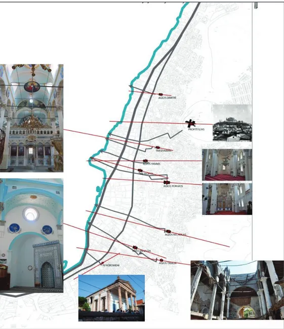
In this historical chronology, we encounter different chronologies in different texts for the churches. The church history followed by Psarros in the process of urban development was chosen in this study. According to the construction dates, the churches are Taksiyarhis, Agios Dimitros, AgiosYannis, MesiPanagia/Metropol, Kato Panagia, Agios Georgios, Agios Nikolaos, Profitis Ilias, and Agia Triada (Figure 8).
Figure 8. Ayvalık’s urban development scheme [25]
When the church architecture is examined generally, a semi-circular structure with a short semi-dome generally located on the short front facade of the church, which determines the worship direction and the direction of the priest's ritual, is observed. The axis taken perpendicular to this structure is called the apse axis.
Therefore, it was determined that the worship direction of 9 churches in the town were almost perpendicular to the coast [26]. As seen in Figure 9, the apse axis of the Feneromoni is almost parallel to the coast. It can be said that this is the effect of being a holy spring instead of a church among the founding elements of the town. There are two transportation axes which can be considered parallel to the coast in the city where the education is intensive, and despite the organic city texture, direct access of the churches especially to these axes is possible. In other words, as the churches have a view of the sea, it is possible to access the coast from the church through a single street. However, there is an exceptional situation in Profitis Ilias Church, located at the highest point of the city. Due to the high rates of education, the most organic texture in the city is formed around this church. Accordingly, there is an indirect access to the coast; but in terms of view, the church which is clearly the most associated with the sea, is Profitis Ilias Church.
Within this context, the structural dominance separated from the traditional house structure formed by the churches has caused them to form an assembly area due to the hilly topography. These churches, as benchmarks with the important axes that go down to the coast, have turned into centripetal objects that reveal themselves on the sloping land.
Figure 9. Upside axes of Ayvalık Churches produced under the study
5.3. Assembly Areas
The churches read as centripetal, pivotal objects in settlement are important landmarks in Ayvalık topography within the scope of the study. Although some churches have been converted into mosques, schools and warehouses with different functions, it was observed that they have exhibited a decentralized standing with their monumental presences for the social relations established by the town-dwellers and the new spatiality they created, with the transmission of social memory and experiences.
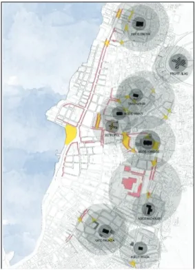
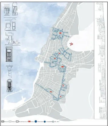
Figure 10 focuses on the physically existing churches, their access and diffusion areas were separated with grey rings according to their intensity, and the surrounding intersection points and their incidences have been determined. It has been observed that the determined assembly areas are in association with current trade links and the red commercial axles were processed in addition to the gathering areas indicated with yellow spots. Thus, the assembly areas, intersection points and trade links have been revealed.
In line with these analyses carried out around the churches, it was observed that the spreading, access areas and gathering areas formed around them were generally at intersection points and these medium focuses were supported by trade function.
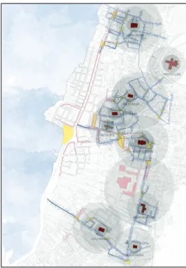
Figure 10. Focal-Point Centered Assembly Areas and Links produced within the scope of the study The gathering spaces around the religious buildings continue to be the areas that the locals of Ayvalik still carry out their daily routines that allow new encounters and relations. These focal points, which bring the locals and visitors together, also caused commercial relations to shift towards this point from the coast. It was observed that each focus had a different spatial characteristic when the present usage patterns of the intersection points are examined over the assembly areas and commercial relations determined under the focus of churches (Figure 11).
The links of the churches deemed as focus points are shown in red, and the physical connections of the assembly areas are shown in gray. In this study, two of the study groups carried out researches on the use of intersection points allowing spatiality and socialites under the focus of churches on the central settlement of Ayvalık.
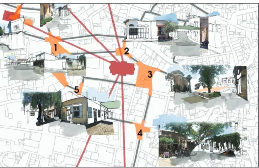
Figure 11. Focal-Point Centered Gathering Areas and Links produced within the scope of the study In order to illustrate the detailed examination of these intersection areas determined under the focus of churches, the assembly areas located around the AgiosYorgios Church, named as Çınarlı Mosque today, have been numbered in Figure 12.
Figure 12. A Detail from Focal Points Centered Assembly Areas-Links and Identity Elements Produced within the scope of the study.
The observed differences and use patterns of these intersection points will be explained under a sequence number.
The assembly area no 1 is the largest gathering area around Çınarlı Mosque and the area where trade function is the most intensive. For this reason, it is an area where the user density is high and continuously moving. All the spots surrounding the intersection point have a commercial function.
The assembly area no 2 was formed by connecting a narrow street, which coincides with the gate of the mosque garden, to the main street. Since the mosque’s gate coincides with this intersection point, it is an area where the mosque community usually convenes and spends time and where male users are dominant. As the user density continues for long and without any interruption, the top coverings and olive trees are frequently seen in the streets of Ayvalık.
The assembly area no 3 consists of a small square which corresponds to the apse of the church with a short distance connection with area no 2. Since there is a big tree and a large space in its center, it turns into a bazaar area on certain days of the week.
The assembly area no 4 is an area where the user population is diversified when compared to other assembly areas and the commercial function is intensive. The tables and chairs of the cafes that extend out are seen as the reflection and continuity of the culture of spending time and sitting in the street. Contrary to other assembly areas, it is an intersection point attracting the tourists in Ayvalık since the commercial function here consists generally of the cafes.
The assembly area no 5 is a vista point establishing a visual relationship with the assembly area no 1 and in which we can observe both religious structures at the same time. Again, contrary to other areas, this point, which has a high concentration of commercial functions, also contains functions that can serve the locals and the owners of the nearby houses.
6. SYNTHESIS
In the study conducted with the assumption that the settlement texture is formed around the religious buildings in the central settlement of Ayvalık, after defining the links and relations of the focuses with present trade connections, the relations between the houses and the gathering points were defined. In order to be able to read the inner-outer and private-public area connections through parcel, building and street relation, the relations of the doors with the street as permeability and interface objects were examined.
The doors can be seen as the physical layers through which we can read the performances, movement and time of daily routines. They are interfaces that connect the inner to the outer by restricting the daily activities of the town-dwellers between the private and public area. Three different doors were observed in Ayvalık in the singular buildings surrounding the churches and assembly areas. These are the building entry doors, store doors and garden doors that differ in quality and scale. While these physical interfaces, which are part of the daily routines of the town-dwellers, facilitating the visual monitoring of street texture, they are involved as founding elements for the town-dwellers to participate in routine activities and encourage them to spend time on the streets.
While the entrance door and the garden door are the interfaces that open to the daily flows of the private area of the town-dwellers, the store door is the door where people dealing with olive cultivation mostly kept their jugs in the past. In this case, we can assert that while entrance and garden doors were defining the social thresholds, boundaries and passages, the store door allows the basic elements with which the town-dwellers provide their livelihood and which constitutes the economy of the town to be read through physical traces. Therefore, the visual theme constituted by the single buildings throughout the town provides social thresholds and information source about the historical process of the town (Figure 13).
Figure 13. Relations between doors and assembly points produced within the scope of the study.
7. CONCLUSION
In the historical process, Ayvalık has become the most active harbor following Izmir. As a natural harbor on the sea routes from the beginning of the 19th century and being a production center with its soap and olive oil factories, Ayvalık continued its close relationship with other islands. The economic structure and production relations shaped by industrial and maritime trade activities influenced the population movements of Ayvalık as well as the formation of its urban texture, space setup and the diversity of buildings [27].
It is possible to understand this unique structure of the settlement’s spatial setup through many components constituting the town. From the building scale to the traces of the road system, the effects of the natural structure and to the articulation of public spaces, formations provide us clues about the place. As a coastal settlement, the spatial organization of other public buildings, such as factories and customs buildings, has determined a specific coastal use. Together with this coastal use, although it may appear as if the production-trade and administrative activities and housing areas have been separated in the morphological setup of Ayvalık, after a deeper examination it becomes obvious that these relations have been interlaced. For example, workshops with separate entrances on the base floors of the houses were used as olive oil and wine production areas and have constituted a part of the economy of the city.
Another form of relationship with the coast is the wind corridors formed by the streets going down perpendicular from the housing areas to the coast. It is also known that along with the streets as the urban living spaces, the churches are important focal points and benchmarks. In addition to these features, the squares formed around the churches define the meeting points of those who live there.
Within this context, the social changes experienced by Ayvalık in the historical process appear under the unifying effect of geography with a mixed structure formed by common habits and cultural elements. The reflection of this mixed structure on the urban space should be considered as common values between cultures that penetrate through the sea gates of the town as well as the social relations that extend from the interior space to the street. Together with all these features, Ayvalık town symbolizes the continuity of a common memory.
REFERENCES
[1] Latour, B., 2007. Reassembling the Social: An Introduction to Actor-Network-Theory, Oxford
University Press, Oxford & New York.
[2] DeLanda, M., 2009. A New Philosophy of Society: Assemblage Theory and Social Complexity,
Continuum, London & New York.
[3] Braudel, F., 2013. Akdeniz: Tarih, Mekân, İnsanlar ve Miras, Tr: Necati Erkurt, Aykut Derman,
Metis Yayıncılık, İstanbul.
[4] Braudel, F., 2017. II. Felipe Döneminde Akdeniz ve Akdeniz Dünyası – I, La Mediterranee et le
monde mediterraneen a l’epoque de Philippe II, 1949.Tr:M.Ali Kılıçbay, Doğu Batı Yayınları, pg:465-469, İstanbul.
[5] Image Produced by the students of Planning Studio 2017, MSGSU Department of City and Regional
Planning.
[6] Simmel, G., 2009. Bireysellik ve Kültür, Tr: TuncayBirkan, Metis Yayıncılık, s:65-69, İstanbul. [7] Simmel, G., 2013. Köprü ve Kapı, Tr: Özgü Ayvaz, Felsefelogos, 2013/3 Yıl 17 Sayı: 50, Bizim
Kitaplar, pg:19, İstanbul.
[8] Pekin, M., 2014. Mübadele Öyküleri: Mübadele’nin 85.Yılı Öykü Yarışması Seçkisi, LMV, İstanbul. [9] Kalogeropoulou Yalçın, E.2017.Apolyont’un Sakinleri: Mekân, Bellek ve Tarih, Nilüfer Belediyesi,
Bursa.
[10] Yurt Ansiklopedisi,Ayvalık, Cilt 2, pg.1125.
[11]Ertürk, H. Yeşim,1990. Balıkesir İli Ayvalık İlçesinde Bir Grup Yapı İçin Restorasyon Tasarımı,
Yüksek Lisans Tezi Mimar Sinan Üniversitesi Fen Bilimleri Enstitüsü Restorasyon Anabilim Dalı, pg.6-15
[12] Yurt AnsiklopedisiAyvalık, Cilt 2.
[13] http://pirireisharitalar.blogspot.com.tr/
, last accessed on May 2018.
[14] Yurt AnsiklopedisiAyvalık, Cilt 2
[15] Erim, H., 1948. Ayvalık Tarihi, Güney Yayıncılık ve Gazetecilik, Ankara. [16] Aka, D., 1944. Ayvalık İktisadi Coğrafyası, Ülkü Matbaası, İstanbul.
[17] Özel, K., 2012. Kent strüktürü ile tapınma yapıları arasındaki ilişki bağlamında Ayvalık Hamidiye
Camisi, Tasarım+ Kuram Dergisi 7, pg:11-12
[18] Yorulmaz, A. 2005. Ayvalık’ı Gezerken, İstanbul: DünyaYayıncılık.
[19] Kuran, A., 2000. 19. Yüzyıl Osmanlı Mimarisi, Celal Esat Arseven Anısına Sanat Tarihi Semineri
(İstanbul 1994), Seminer Bildirileri, Mimar Sinan ÜniversitesiYayını, İstanbul. pg. 232-237.
[20] Akın, B., 2015. Ayvalık Evleri’nin Cephe Karakterinin Oluşumuna Etki Eden Faktörlerin
Değerlendirilmesi, Sanat Tarihi Dergisi, Cilt/Volume:XXIV, Number:2,Ekim/October, İstanbul, pg.121-138.Ü
[21] https://tr.wikipedia.org/, last accessed on May 2018, last accessed on May 2018. [22] https://4.bp.blogspot.com/s1600/ayvalik-depremi-6.jpg, last accessed on May 2018. [23] http://wowturkey.com/tr291/mert1969_ayvalikiskele.jpg, last accessed on May 2018.
[24] https://4.bp.blogspot.com/s1600/ayvalik-hurriyet-gazetesi-1960.jpg, last accessed on May 2018. [25] Psarros, D. E., 2004. Kydonies-Ayvalık’s Urban History,1.Conference of Two Sides of Aegean,
Ayvalık, Turkey, October 28-30, 2004
[26] Kıyak, A. E., 1997 Kentin Biçimsel Ve Mekansal Kurgusunun Çözümlenmesine Dair Bir Yöntem
Önerisi Ve Ayvalık Örneği, İstanbul Teknik Üniversitesi, Fen Bilimleri Enstitüsü Yüksek Lisans Tezi, İstanbul. Pg:135.
[27] Akın, B., 2015.
“
19.Yüzyıl Uluslararası Deniz Ticaretinin Batı Anadolu Yerleşimlerine SosyoEkonomik ve Mekansal Yansımaları/Ayvalık Örneği
”
Ordu Üniversitesi Sosyal Bilimler Araştırmaları Dergisi, Temmuz 2015, Türk Deniz Ticareti Tarihi Sempozyumu VII- Karadeniz Limanları Özel Sayı, pages:7-23,ISSN:1309 - 9302GÜLŞEN ÖZAYDIN, Prof. Dr.,
İstanbul Technıcal Unıversity Maçka Faculty of Architecture 1982, Mimar Sinan University Urban Design Higher Education 1984, Mimar Sinan University Department of Urbanism Postgraduate 1994, Department of Urban Design Science Readership 2002, she has been working in Mimar Sinan Fine Arts University, Department of Urban and Regional Planning since 2009.
MÜGE ÖZKAN ÖZBEK, Dr. Lecturer,
Was born in İstanbul. Held her B.Arch degree at Yıldız Technical University in 1998, M.Arch degree and Ph.D at Mimar Sinan Fine Arts University City and Regional Planning Dept. Urban Design Department. Working as a Dr. Lecturer in the same department since 2000.
LEVENT ÖZAYDIN, Dr. Lecturer,
İstanbul University Faculty of Economics Undergraduate 1982, İstanbul University Social Sciences Institute, Statistics Higher Education 1984, İstanbul University Social Sciences Institute Econometrics Postgraduate 2002,he has been working in Mimar Sinan Fine Arts University, Faculty of Architecture, Department of Urban and Regional Planning since 2002 as assistant professor.
ESER YAĞCI, Dr. Lecturer,
Was born in 1979 in İstanbul. Held her B.Arch degree in 2002, M.Arch degree in 2005, and Ph.D in 2013 Worked professionally as an architect and as a part time lecturer at several institutions. Currently is an Assist. Prof. Dr. at Mimar Sinan Fine Arts University Department of Architecture since 2014.
Explorations on “Chora”
Assoc. Prof. Dr. Yasemin İnce GÜNEYDepartment of Architecture, Faculty of Architecture Balıkesir University, Turkey
Abstract: The Ancient Attic Greek word Chora, which is translated as space or place, has been one of the
tropes used by philosophers and architects alike during the end of the twentieth century. Chora, for example, has been one of the privileged deconstructivist terms used by Jacques Derrida as well as Elisabeth Grozs. It has also been one of the key terms used by architectural historian Alberto Perez-Gomez who is well known as an architectural theorist and a promoter of a phenomenological approach to architecture. It is rather intriguing that these different approaches to architecture and architectural meaning both use the notion of Chora which relates to the critical issue of space versus place. Although the notions of space and place have been explored extensively within architectural discourse as one of the keys to architectural meaning, they are not the focus of this research. This study rather is an exploration of the notion of Chora through examining its interpratations by different characters. The aim is to explore possible paths that could open themselves for us to understand architecture and architectural meaning.
Keywords: Chora, space/place, Derrida, Grosz, Perez-Gomez “Chora” Üzerine Keşifler
Özet: Antik Dönem Atik Yunanca diline ait, uzay, mekan, bölge veya mesken anlamalarında kullanılan
Chora kelimesi yirminci yüzyılın sonlarına doğru felsefecilerin ve mimarlık teorisyenlerinin çok kullandığı bir terim olmuştur. Örneğin, Jacques Derrida ve Elisabeth Grozs gibi dekonstruktivist teorisyenlerin kullandığı ayrıcalıklı termlerden biridir Chora. Mimarlık disiplinine fenemenolojik yaklaşımı savunan öncü mimarlık tarihçisi ve teorisyeni Alberto Perez-Gomez’de Chora terimini pek çok çalışmasına konu edinmiştir. Uzay ve mekan konseptlerine dair açıklama getiren Chora teriminin birbirinden farklı bu yaklaşımlar tarafından kullanılıyor olması ilgi çekicidir. Mimaride anlam konusunun temel bileşenlerinden uzay ve mekan kavramları mimarlık disiplininde yirminci yüzyılın belki de en çok çalışılan alanlarından biridir. Ancak bu çalışmanın odak noktasını Chora terimi oluşturmaktadır. Çalışmanın amacı Chora teriminin farklı karakterler tarafından yapılan yorumlarını inceleyerek, bu terimin mimarlık ve mimaride anlam konusunu aydınlatmada bize hangi yolları açabileceğine dair bir keşif yapmaktır.
![Figure 1. Ayvalık Connection Roads and Road Grading [5]](https://thumb-eu.123doks.com/thumbv2/9libnet/4179383.64544/11.892.265.650.373.719/figure-ayvalık-connection-roads-road-grading.webp)
![Figure 3. Ayvalık Map of Piri Reis [13]](https://thumb-eu.123doks.com/thumbv2/9libnet/4179383.64544/15.892.232.685.127.377/figure-ayvalık-map-of-piri-reis.webp)
![Figure 4. The refugees who were obliged to pass to the opposite coast during the exchange [21] There were 18 olive oil factories and 13 soap factories in Ayvalık in 1938](https://thumb-eu.123doks.com/thumbv2/9libnet/4179383.64544/16.892.89.782.544.844/figure-refugees-obliged-opposite-exchange-factories-factories-ayvalık.webp)
![Figure 6.View of Ayvalık Coastal road, 1950’s [23] Figure 7. Hürriyet Newspaper headline[24]](https://thumb-eu.123doks.com/thumbv2/9libnet/4179383.64544/17.892.109.494.671.939/figure-view-ayvalık-coastal-figure-hürriyet-newspaper-headline.webp)
![Figure 8. Ayvalık’s urban development scheme [25]](https://thumb-eu.123doks.com/thumbv2/9libnet/4179383.64544/19.892.118.800.314.646/figure-ayvalık-s-urban-development-scheme.webp)