T.C. ISTANBUL AYDIN UNIVERSITY INSTITUTE OF SOCIAL SCIENCES
THE ROLE OF INTERMODAL TERMINALS IN LOGISTICS AND PROPOSAL FOR INTERMODAL TERMINAL IN ISTANBUL
MASTER THESIS
SALĠH NUHOĞLU
Department of Business
Master of Business Administration (MBA)
Thesis Advisor: PROF.DR. AKIN MARġAP
iii
vi FOREWORD
The growth of logistics sector is speeding up by consumption enhancement. Logistic companies are looking for a way to be efficient and affordable transportation. The critical issue regarding this subject is intermodal terminals. These terminals are effective enough to determine transportation corridors. The strategic advantages of Istanbul, its developing economy and existence of industrial area are good reasons to establish an intermodal terminal in Istanbul. The purpose of this thesis is to propose a cover for the need of intermodal terminal and determine the details, characteristics, situation and position of it.
viii TABLE OF CONTENT Foreword………..vi Table of Content……….……….viii Abbreviations...xii Figures...xvi Graphs...xviii Tables……….…xx Pictures……….………...…..xxii Maps………..xxiv Özet………xxvi Abstract……….…xxx 1. INTRODUCTION ……….………..……….1 2. INTERMODAL TRANSPORTATION………...4 2.1 CONTAINER………..….………….………...5 2.1.1Container Usage……….………..……...….……..7
2.2 INTERMODAL TRANSPORT UNIT (ITU)………..…...11
2.2.1 Container……….…….………...…11
2.2.2 Swap Bodies ……….…….…………12
2.2.3 Semi-Trailers ……….………….………12
2.2.4 Roll-on Frame………..……….……..12
2.3 UNACCOMPANIED TRANSPORT …………..………...…..12
2.4 ROLLING ROAD (ROLA) - ACCOMPANIED COMBĠNED TRANSPORT………...…....………...…13
2.5 ROLL ON, ROLL OFF (RO-RO) SHIPPING………...….14
2.6 PIGGYBACK TRANSPORTATION……….……...………15
2.7 BI-MODAL TRANSPORTATION-ROADRAILER………...16
2.8 TRAIN FERRY TRANSPORTATION……….…….….….….19
2.9 LIFT-ON/LIFT-OFF (LO/LO)………...….19
3. INTERMODAL TRANSPORTATION NETWORK…………..…..22
3.1 TRANS-EUROPEAN TRANSPORT NETWORKS (TEN-T)…………22
3.1.1 Corridors……….…..……..23
3.2 PAN-EUROPEAN TRANSPORTATION NETWORK……….……...37
3.2.1 Corridor I ………...…..……..39 3.2.2 Corridor II………....……...40 3.2.3 Corridor III………...…...…….40 3.2.4 Corridor IV………..………..….…...….41 3.2.5 Corridor V………..……....……42 3.2.6 Corridor VI………..…...……....42 3.2.7 Corridor VII………..……....…..44 3.2.8 Corridor VIII……….……….….…...44
ix
3.2.9 Corridor IX ………...….…....…45
3.2.10 Corridor X………...….…45
3.3 THE MARCO POLO II PROGRAM………...……47
3.4 MEDITERRANEAN AND TRANS-EUROPEAN NETWORKS FOR TRANSPORT………..…..………...48
3.5 TRANS-EUROPEAN MOTORWAYS (TEM)……….…...50
3.6 TRANS-EUROPEAN RAILWAY (TER)………..…...…..51
3.7 ASIAN HĠGHWAY NETWORK……….……...……51
3.8 TRANS-ASĠAN RAILWAY (TAR)………...…..…53
3.9 TRANSPORT CORRIDOR EUROPE – CAUCASUS – ASIA (TRACECA)……….………..…55
3.10 NORTH–SOUTH TRANSPORT CORRIDOR……….…...56
3.11 TRANS AFRICAN HIGHWAYS……….……..…..56
3.11.1 Cairo-Dakar……….….…...59 3.11.2 Algiers-Lagos……….…....….60 3.11.3 Tripoli-Windhoek……….………...…….62 3.11.4 Cairo-Gaborone ………...…...63 3.11.5 Dakar-N‘djamena………..…....…..65 3.11.6 N‘djamena-Djiboutı………...………..66 3.11.7 Dakar-Lagos……….……67 3.11.8 Lagos-Mombasa………...….68 3.11.9 Beira-Lobito………...….….69 3.11.10 Djiboutı-Librevılle-Bata……….70
3.12 INTERMODAL HUB AND SPOKE SYSTEM………...….70
4. INTERMODAL TERMINALS……….…..73
4.1 INTERMODAL TERMINALS WORLD MAIN REGIONS………..76
4.1.1 Shanghai ……….………77 4.1.2 Singapore………...….………78 4.1.3 Shenzhen………...………..……79 4.1.4 Rotterdam……….………...……...…..…..81 4.1.5 Busan………...…….86 4.1.6 Ambarlı……….…...…87
5. INTERMODAL TERMINALS IN TURKEY……….89
5.1 CONTAINER PORT IN TURKEY……….…………....….89
5.2 LOGISTICS VILLAGES IN TURKEY………...…93
5.2.1 Halkalı Logistics Village………...….95
5.2.2 Ġzmit (Köseköy) Logistics Village……….95
5.2.3 Samsun (Gelemen) Logistics Village…….………...…….96
5.2.4 EskiĢehir (Hasanbey) Logistics Village……….…...……..96
5.2.5 UĢak Logistics Village……….…..97
5.2.6 Denizli (Kaklık) Logistics Village………....…...….97
5.2.7 Balıkesir (Gökköy) Logistics Village……….….….….97
5.2.8 Bilecik (Bozüyük) Logistics Village………..…………98
x
5.2.10 Erzurum (Palandöken) Logistics Village……….…….98
5.2.11 Mardin Logistics Village………..……….……99
5.2.12 Ġstanbul (YeĢilbayır) Logistics Village…………...…….….99
5.2.13 Kars Logistics Village……….….………….99
5.2.14 Habur Logistics Village……….……...99
5.2.15 Bitlis (Tatvan) Logistics Village………..…..100
5.2.16 Sivas Logistics Village……….…….….100
5.2.17 KahramanmaraĢ (Türkoğlu) Logistics Village………...…....100
5.2.18 Konya Logistics Village……….………....100
5.2.19 Kayseri (Boğazköprü) Logistics Village………..…..100
6. LOGISTICS SECTOR ANALYSIS AND RECOMMENDED STRATEGY ABOUT INTERMODAL TERMINALS. (TURKEY IN GENERAL AND ISTANBUL IN PARTICULAR)……….………..102
6.1 COMPARING WORLD‘S LOGISTICS INFORMATION WITH TURKEY‘S……….……102
6.2 COMPETITIVE POWER OF LOGISTICS INDUSTRY IN TURKEY………....…….106
6.3 SUGGESTIONS TO IMPROVE TURKEY‘S FUTURE LOGISTICS STATUS………..…..…...108
6.4 A PROPOSAL FOR INTERMODAL TERMINAL IN ISTANBUL………..……...….112
6.5 ECONOMIC DIMENSION OF INTERMODAL TERMINALS...…123
6.6 LOCATION OF PROPOSED INTERMODAL TERMINAL ESTABLISHMENT IN ISTANBUL………..………..…….125
7. CONCLUSION……….……..….131
xii Abbreviations
ADB: African Development Bank AH: African Highway
ALTID: Asian Land Transport Infrastructure Development CEF: Common European Framework
COFC: Container on Flatcar
COSCO: China Ocean Shipping Company DWT: Deadweight long tons
EC: European Commission
ECMT: European Conference of Ministers of Transport EEA: European Economic Area
EFTA: European Free Trade Association
ERTMS: European Rail Traffic Management System
ESCAP: Economic and Social Commission for Asia and the Pacific EU: European Union
EUR: Euro
GNP: Gross national product IGA: Intergovernmental agreement IGC: Intergovernmental Commission IMM: Istanbul Metropolitan Municipality ISO: Istanbul Chamber of Industry ITU: Intermodal transport unit IWW: Inland waterway JIT: Just in time
xiii LO-LO: Lift on Lift off
M: Meters
MEDA: Mediterranean and Trans European Network MOU: Memorandum of understanding
NIS: New Independent States
OECD: Organization for Economic Co-operation and Development PPP: Public–private partnership
R&D: Research and development RO-LA: Rolling Road
RO-RO: Roll on Roll off SQ: square
TAH: Trans African Highways TAR: Trans African Railway
TCDD: Türkiye Cumhuriyeti Devlet Demiryolları TEM: Trans European Motorways
TEN-T: Trans-European Transport Network TER: Trans European Railway
TEU: Twenty-foot equivalent unit TOFC: Trailer on flatcar
TRACECA: Transport Corridor Europe-Caucasus-Asia
UNCTAD: United Nations Conference on Trade and Development UNDP: United Nations Development Program
UNECA: United Nations Economic Commission for Africa
xvi FIGURES
Figure 1.1 Container usage rates……….8
Figure 1.2 Container usage………..8
Figure 1.3 Idle container fleet rates……….9
Figure 1.4 World container traffic………..…..……10
Figure 1.5 Intermodal Transport Unit Types………..……….11
Figure 1.6 Unaccompanied Transport………...………..13
Figure 1.7 Rolling Road (RO-LA)………..………..14
Figure 1.8 Piggyback Transportation………...16
Figure 1.9 Bimodal system Trailer-Train……….18
Figure 2.1 Scandinavian - Mediterranean Corridor Map………..25
Figure 2.2 Rhine-Danube Corridor………...….33
Figure 2.3 Two examples of point-to-point bundling networks connecting three origin terminals and three destination terminals being transformed to a hub-and-spoke network……….………...72
Figure 3.1 Container Throughput for Shanghai in TEUs ………..………77
Figure 3.2 Shenzhen Port Handling Statistics ………..………….………80
Figure 3.3 Port of Rotterdam Container Throughput 2004 to 2013……….……...84
Figure 3.4 Incoming and Outgoing cargo in Rotterdam 2012-2009…………...…..85
Figure 3.5 Busan ports local container throughput 2002 to 2013………….……....87
Figure 3.6 Ambarlı port container throughput 2007-2013………..…..88
Figure 5.1 Estimated pickup truck movement of Istanbul in terms of geography in 2023………...117
Figure 5.2 Estimated trailers movement of Istanbul in terms of geography in 2023………..………..…..118
xviii GRAPHS
Graph 4.1 Turkey 2009-2030 Year Total Load Forecasting (TEU)………..92 Graph 5.1 Ports of Marmara region container throughput (TEU)………...122
xx TABLES
Table 1.1 Intermodal Freight Transportation……….5
Table 1.2 Container sizes……….6
Table 1.3 Container Traffic Volumes………..………..10
Table 2.1 North Sea-Baltic Corridor Pre-Identified Projects………..…...26
Table 2.2 North Sea-Mediterranean Corridor Pre-Identified Projects…………...27
Table 2.3 Atlantic Corridor Pre-Identified Projects……….…..32
Table 2.4 Mediterranean Corridor Pre-Identified Projects………..….….35
Table 2.5 Pan-European Corridors………...……..38
Table 2.6 Technical Features Of Corridor III……….…..…..41
Table 2.7 Status of the Asian Highway in Member States in 2006…….……..…53
Table 2.8 TAR routes………...……..55
Table 2.9 Main Trans African Highways Length………..58
Table 3.1 Top 10 World Container Ports………..…….76
Table 3.2 Shenzhen Port handled information……….………..80
Table 3.3 Throughput port of Rotterdam………..…….83
Table 4.1 Throughput container in Turkish ports………..90
Table 4.2 Top 10 Ports Throughput Container in Turkey………..……91
Table 4.3 Belongs to the container handling port of Turkey 2015-2023 Year Total Load Forecasting (TEU)……….……….………92
Table 5.1 Capacity of Turkey's ports by regions in 2009……….………113
Table 5.2 Estimated local container handled in the Marmara region ...…………114
Table 5.3 Estimated total container handled (with transit) in the Marmara region...114
Table 5.4 Pickup truck movement of Istanbul in 2009……….…115
Table 5.5 Truck movement of Istanbul in 2009………116
xxi
xxii PICTURES
Picture 1.1 RO-RO Shipping………...….…..15 Picture 1.2 Train-Ferry Organization………...……....19 Picture 1.3 Lo-Lo Operations………21 Picture 2.1 Hub and Spoke Network………...…..…71 Picture 4.1 Logistics village in Turkey………...……..94 Picture: 6.1 Ġzmir Aliağa Port………..129 Picture: 6.2 Port of Mersin………..130
xxiv MAPS
Map 2.1 Baltic-Adriatic Corridors ………….………….………..………...….28 Map.2.2 Orient/East-Med Corridor……….…….……….…….30 Map 2.3 Rhine-Alpine Corridor Map……….………..…..31 Map 2.4 TEN-T CORE NETWORK………..36 Map 2.5 Pan-European Corridor VI………...………....…...43 Map 2.6 Pan-European Corridors………..……….……..….46 Map 2.7 Mediterranean and Trans-European Network for Transport and corridors……….….…………49 Map 2.8 Trans African Highways……….….………..……..59 Map 2.9 Cairo-Dakar Corridors……….………...……..60 Map 2.10 Algiers – Lagos Corridor………...61 Map 2.11 Tripoli - Windhoek Corridor………...……..63 Map 2.12 Cairo Gaborone Corridors……….………64 Map 2.13 Dakar N‘djamena Corridors……….……….65 Map 2.14 N‘djamena Djibouti Corridors……….……….……….66 Map 2.15 Lagos - Dakar Corridor……….………….67 Map 2.16 Lagos – Mombasa corridor………..……..68 Map 2.17 Beira – Lobito corridor……….…..69 Map 3.1: Singapore Map………..…….…..78 Map 3.2 Historical Development of the Port of Rotterdam………..…….82 Map 3.3 Port of Busan………...……….………..……….86 Map 5.1 Chosen Area………..….………...126 Map 5.2 Chosen Area……….….………..…..…126 Map 5.3 Future image of Istanbul map………..…….…128
xxvi
THE ROLE OF INTERMODAL TERMINALS IN LOGISTICS AND PROPOSAL FOR INTERMODAL TERMINAL IN ISTANBUL
ÖZET
Dünyanın artık küresel köy olarak anılmasında lojistik süreçlerin payı çok büyüktür. Lojistik tüketimle doğru orantılı Ģekilde artan bir yapıya sahiptir. Dünyada ticaret hacmi 16 trilyon dolara, lojistik hacim ise 6,4 trilyon dolara ulaĢmıĢtır. Yani ticaret hacminin yaklaĢık yüzde 40‘ı lojistik faaliyetlerden oluĢmaktadır.
Türkiye 600 milyar dolarlık mal hareketi içinde yer alan bir konuma sahiptir. Üç tarafı denizlerle çevrili, Asya Avrupa bağlantısı, Karadeniz ve Akdeniz de önemli rolü ile Türkiye lojistik faaliyetlerin odağı olabilecek durumdadır. 2023 hedeflerinde Türkiye lojistikte Ġstanbul‘u merkez haline getirme hedefi belirlemiĢtir. Bu misyonu üstlenebilmesi için intermodal taĢımacılık ağlarını ve intermodal terminalleri güçlendirmesi gerekmektedir.
Bu tezin ilk kısmında intermodal taĢımacılığın doğuĢuna sebep olan konteynır ve tipleri araĢtırılmıĢtır. Konteynırın bulusuyla iĢ gücündeki hafifleme modlar arası geçiĢ kolaylaĢtırmıĢ bununla birlikte fazladan yükleme boĢaltma iĢlemi olmadan taĢımacılık modları arası bağlantılar artmıĢtır. Konteynırın taĢımacılık üzerindeki olumlu etkisiyle birlikte modlar arası geçiĢi sağlamak üzere çeĢitli operasyonlar da kullanılmıĢtır. Örneğin; Bimodal system Trailer-Train. Bu tür süreçlerde taĢıma modlarının birbirine entegresi sağlanmıĢtır. TaĢımacılık süreçlerinin azalmasına neden olan bu operasyonlarla birlikte maliyetler azalmıĢtır. Son kullanıcıya uzanan teslim suresi azalmıĢ ticaret hacimleri geniĢlemiĢtir. Konteynır ve taĢıma entegre modlarıyla birlikte dünyada intermodal ve taĢımacılık radikal değiĢikliklere uğramıĢtır.
Tezin ikinci bölümünde intermodal taĢımacılık ağları detaylı bir Ģekilde ele alınmıĢtır. Radikal değiĢiklikler sonucunda intermodal taĢımacılık artmıĢ ve bu süreçleri dünya kurduğu taĢımacılık ağları üzerinden yönetmiĢtir. Trans-Avrupa taĢımacılık ağı bu anlamda bilinen en yaygın ağlardandır. Her taĢımacılık ağı kendi içinde koridorlara ayrılmıĢ ve bu koridorlar üzerinde ana merkezler belirlenmiĢtir. Bu
xxvii
sayede bu ağlar üzerinden ticaret geniĢlemiĢ rota üzerinde bulunan ülkeler bu yönden güçlü altyapıya sahip olmuĢlardır.
Tezin üçüncü bölümünde intermodal terminaller ele alınmıĢtır. Bu bağlamda taĢıma ağları üzerinde bulunan intermodal terminaller incelenmiĢtir. Ġntermodal terminallere en güzel örneklerden biri olan limanlar incelenmiĢ dünyada ve Türkiye‘de intermodal terminaller ele alınmıĢtır. Ġstatistiki bilgilerle durum karĢılaĢtırılmıĢ altyapı eksiklikleri ortaya çıkarılmıĢtır.
Tezin dördüncü bölümünde Türkiye‘de intermodal terminallerin durumu incelenmiĢtir. Mevcut devlet desteğine ve TCDD yatırımlarına rağmen intermodal terminallerin henüz kendi kapasitelerine çıkamadığı tespit edilmiĢtir. Türkiye‘nin coğrafi konumu ve dünya mal hareket geçiĢinin ortasında olması nedeniyle intermodal terminal ve intermodal taĢımacılık projelerinin daha ivmeli bir Ģekilde devam ettirilmesi gereği görülmüĢtür.
Tezin son bölümünde dünyada ve Türkiye‘de lojistik ve ticaret verileri karĢılaĢtırılmıĢtır. Türkiye‘de kurulması gerekli olan intermodal terminal önerilmiĢ ve bunun Ġstanbul‘a kurulması savunulmuĢtur. Bu bölümde intermodal terminalin nasıl olması gerektiği ve neden Ġstanbul‘un kuzeyine kurulması gerektiği savunulmuĢtur.
3. Havalimanı olarak adlandırılan ve yaklaĢık yıllık 150 milyon yolcu kapasitesiyle dünyanın en büyük projelerinden olan bu havalimanı Türkiye‘nin hava taĢıma anlamında rekabet gücünü ciddi anlamda artıracak ve ülkeyi ciddi anlamda bir hava kargo merkezi haline getirecektir. Diğer yandan yapımı devam eden Yavuz Sultan Selim köprüsü ve yolları üzerinden Asya-Avrupa bağlantısında bir otoyol daha açılacak olup Ġstanbul‘un bu yönden gücünü arttıracaktır. Ayrıca bu köprü üzerinde yapılacak olan tren projesiyle Anadolu‘dan Avrupa‘ya ve tersi istikamette mal hareketi hızlanacak ve maliyetler düĢecektir. Bir diğer yandan henüz projelendirme aĢamasında olan Kanal Ġstanbul projesinin hemen yanında önerilen intermodal terminal deniz yolunda boğaz trafiğine takılmadan geçiĢ sağlayacaktır. Bu tezde Ġstanbul‘a kurulaması önerilen intermodal terminal bahsedilen bütün bu avantajları içerisinde toplayacak olup konumu itibariyle ayriyeten bir liman projesidir.
xxviii Anahtar Sözcükler 1. Intermodal terminal 2. Koridor 3. Lojistik 4. TaĢımacılık 5. Ġstanbul
xxx
THE ROLE OF INTERMODAL TERMINALS IN LOGĠSTICS AND PROPOSAL FOR INTERMODAL TERMINAL IN ISTANBUL
ABSTRACT
The role of logistics process in calling the world as global village is a lot. Logistics as a growing structure is directly proportional to the consumption. World trade volume increased to 16 trillion dollar and logistics volume reached to 6.4 trillion dollar. So about 40 percent of the trade volume consists of logistic activities.
Turkey has a location within 600 billion worth of goods movement. Surrounded on three sides by the sea, connecting Asia and Europe and by its important role in Black Sea and the Mediterranean Sea, Turkey is in a situation to be a centre for logistics activities. In 2023 Turkey has set a target goal to make Istanbul a center of logistics. In order to undertake this mission Turkey must strengthen the intermodal transport network and intermodal terminals.
In this study, intermodal transport in the world and Turkey, these types of transport networks and intermodal terminals were investigated. However, an intermodal terminal is proposed to be made in Istanbul.
Key words 1. Intermodal terminal 2. Corridor 3. Logistics 4. Transportation 5. Istanbul
1 1. INTRODUCTION
Intermodal transportation is one of the new methods in international trade. Due to effective globalization, International trade grows rapidly. The survey includes the features of transportation corridors which are usually used by intermodal transportation all over the world and especially in Turkey. At the same time the intermodal terminals that are using ports have been investigated and compared by using statistical figures.
Logistic process has a huge role in calling the world as global village. Logistic has a direct relation with consumption. World trade volume increased to 16 trillion dollar and logistics volume reached to 6.4 trillion dollar. So about 40 percent of the trade volume consists of logistic activities.
In 2023 national income in Turkey would be 2 trillion dollars; national income per person would be 25 thousand dollars. The predicted goal for Turkey is to increase export rate to 500 milliard dollars and to be one of top 10 economy of the world.
Turkey has a location in which 600 billion worth of goods could be moved in it. Surrounded on three sides by the sea, connecting Asia and Europe and by its important role in Black Sea and the Mediterranean Sea, Turkey is in a situation to be a centre for logistic activities. According to government master plans for 2023, Istanbul is predicted to be logistic hub of the world. So Turkey should be able to empower intermodal transport network and intermodal terminals.
Total demand for container handling in Turkey is estimated to be 10.7 million TEU in 2015 and in 2030 will be 39.9 million TEU. 9 million TEU capacities seem to be sufficient until 2014. Turkey needs new container handling capacity. This capacity is possible by new project or expansions of existing port terminals.
Logistic performance index (LPI) is the critical issue about the effect of international trade from logistics. According to a research in 2014 Turkey is located in the 30th row of LPI list. The LPI analyze is based on many issues which are; the activity of
2
customs, the necessity of infrastructure trade and transport, the decreased bureaucracy of shipment, the adequate capacity of logistics services—trucking, forwarding, and customs brokerage, following up shipment and delivery time(The World Bank; 2012).
In 2012 Turkey is the biggest exporter of goods with the amount of 153 billion dollar also Turkey is the 15th biggest importer with the amount of 237 billion in the world. In the meantime it is the 17th biggest service exporter with the amount of 42 billion also our country is the 27th biggest service importer with the amount of 19 billion dollar (World Trade Organization; 2012).
Factors that will affect the future of the World Trade which are; Trends in International Trade, Economic Factors Affecting International Trade; Openness to trade and wide socio-economic context and Prospects for the Multilateral Trade Cooperation(World Trade Organization; 2012).
The volume of the logistics industry reached 8 trillion dollar in the world, the industry is estimated to reach to 10-12 trillion dollars in 2015. Turkey has to get a share from this industry using strategic position.
According to research of JLL, with the effect of increasing foreign investment in the logistics industry is expected to grow 48 percent in 5 years. According to same research Turkey the fastest growing logistics was second after Russia.
One of the biggest problems of the logistics sector is Turkish logistics sector doesn't increase parallel with the volume of foreign trade developed at the same rate.
75% of the logistics activities in our country is currently engaged in manufacturing firms are covered by the resources in their internal structure. This action prevents the development of the logistics industry and sector cannot afford the desired level.
3
Despite Turkey is located on world trade way, it does not have the ability of giving logistical service to the other countries because of lack of infrastructure. That why this thesis offers an intermodal terminal which can easily reach intermodal transportation network. This terminal would be world‘s biggest intermodal terminal which includes four main logistical activities.
Turkey‘s logistic details were investigated and compared with World‘s. According to this research, generally in Turkey especially in Istanbul the need for an intermodal terminal is obvious and this terminal is highly offered to get started as a huge project. Finally the physical situation and location of the project is offered and the explanation of why this location is selected is given at the end.
4 2. INTERMODAL TRANSPORTATION
Intermodal transportation is a term to explain the connection of two or more transportation types which work together in order to freight a cargo from origin to the last user which is at the destination. This procedure initially started by containers (Novack, 2006; 211).
Intermodal freight transport is activity in which cargos deliver on one unit. This activity happens between two or more transportation types without handling the cargo itself (European Conference of Ministers of Transport (ECMT) and European Commission (EC), 2001; 17).
The critical factors for intermodal operators and companies is point-to-point bundling concept which should be affordable trustworthy. Point-to-point bundling is a procedure in which the cargo that is load at the origin on the train totally goes to destination point (Bontekoning, 2006, 1).
According to combined transport technology have prepared with the of The United Nations Economic Commission for Europe (UNECE or ECE), European Conference of Ministers of Transport (ECMT) and European Commission (EC) intermodal transportation is kind of transportation without classification, same loading unit (for example container) and two or more than transportation modes (UNECE, 2001).
According to European Union (EU) intermodalism is to provide a back field warranty of different shipping models in order to respond customer demands offering door-to-door service, this means that the transportation system will work adequately and profitably while encouraging between competitors (BektaĢ, 2007; 2).
The transshipment yards are the designed terminals which specially used for changing the transportation modes by transferring the loading units without discharging the freight itself (Nossack, 2013; 2).
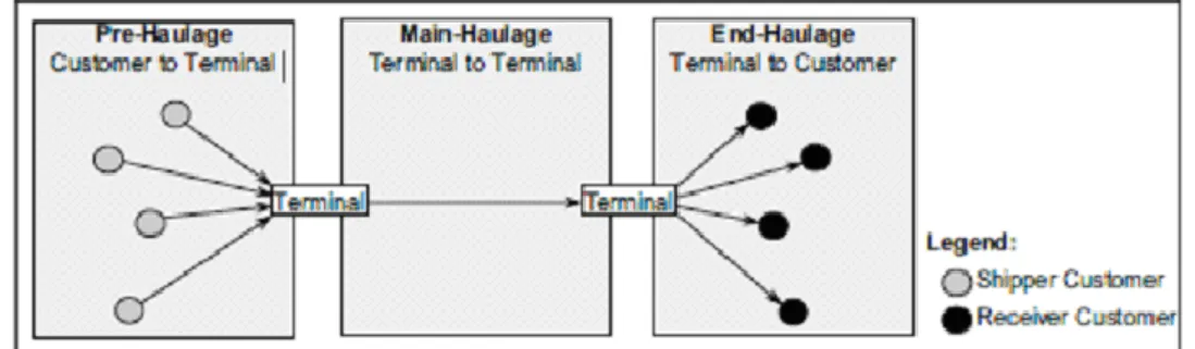
5
Intermodal transportation has three levels; first is pre-haulage, second is main-haulage and last one is end-main-haulage which refers to first step customer to terminal, second terminal to terminal and terminal to customer (refer to table1.1).
Table 1.1 refers to intermodal freight transportation.
Tab. 1.1: Intermodal Freight Transportation (Nossack, 2013; 2).
2.1 CONTAINER
Containers are produced of steel box-shaped in order to carry or transfer goods in a safe way which can be carried on truck, train and ship between international transportation units.
The improvement of the intermodalism is because of developing entrance of containers. Malcolm McLean is a successful truck line owner, he create the fact of using a trailer to freight by both highway and seaways in the mid-1950s. He is created the operation improved and at the end it became to be one of the largest seaways carriers (Coyle, 2010; 211).
The most important role in intermodal transportation development was the role of containers. Container is a kind of transportation unit that different kinds of goods could be load on it facilitates the transferring job between different transportation types and this procedure is a time and money saving. Also safe load and discharge is another advantages of this procedure.
6
1. "Container" means an article of transport equipment:
(a) Of a stable texture and in respect of that suitable for repeated use,
(b) Designed to ease the transportation of goods by one or more types of shipping without loading over and over,
(c) Suitable use by supporting corners for secure,
(d) For main types it has an area which is closed by four sides. (i) At least 14 sq. m. (150 sq. ft.) or
(ii) At least 7 sq. m. (75 sq. ft.) if it is fitted with top corner fittings;
Container are used on wheel vehicle they do not include vehicles and packaging.
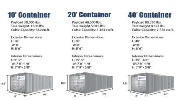
Table 1.2 refers to Container Alliance firm of rental container size and types.
Tab. 1.2: Container sizes (Container Alliance - The Storage & Shipping Container Network; http://www.containeralliance.com/california-container-rentals.php; 10.03.2014)
7
Container causes radical changes in world marine sector. For example in traditional discharge system discharging 40.000 tons needs 24.000 man/time but container ships needs 750 man/time for discharging the same amount. Previously ships waits for discharge 25 days, this period decreased just two days by the use of containers (Slack,2001:143 Transmitting:MuhteĢem Kaynak-Hülya Zeybek, Logistics Centers in intermodal terminals Development, Distribution and State Parks in Turkey;2007;42).
2.1.1 Container Usage
Intermodal is a transportation mode which includes two or more different kinds of shipping methods. When goods from one to another type of transportation the risk of damaging and loss would happen, also more time would be waste. Main challenge is to minimize the transit time. The company has to manage handling cost in order to decrease transportation cost. That‘s why using container is essential.
In order to minimize waiting time the usage of same containers is prefered, this is one of the updated technology which is newly founded to standardize transportation. In addition companies prefer systematic transfer firstly; they use trailers in order to transfer cargos. This is going to be very safe and fast from a truck to the train. Suitable ways to ensure the security of goods are containers. The only difficulty is the weight of containers which are hard to be transported. The rail containers are lighter than sea containers these two forms usually come together with road transportation. After that to transfer the cargo between two modes the carriers are used two develop the activity. Even in some cases the whole truck is transported by train (Gourdin, 2001 Transmitting Prokopowicz; Outsourcing in Transportation; 2010; 9).
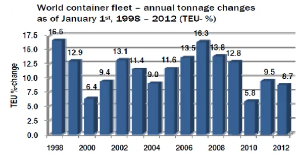
Figure 1.1, 1.2, 1.3 refers to world container fleet annual tonnage changes as 1998-2012, tonnage additions and idle container fleets 2008-2012.
8
Fig.1.1 Container usage rates (ISL Shipping Statistics and Market Review; 2012)
The figure 1.1 is an explanation for world container fleet annual tonnage changes comparing to the previous year. For example in 2002 the increase rate was 13.1 comparing to 2001. Between 1998 and 2012 world container fleet increased to 500%. The pick of this figure is in 1998.
9
According to figure 1.2 the huge change happened two times. The first one was between 1999 and 2000 and the second one was happened 2004 and 2005. The highest amount was in 2008. The amount was more than 18 million mt. The highest reduction was in 2009.
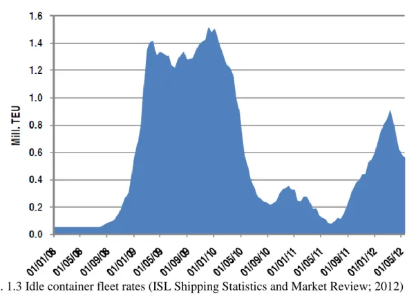
Figure 1.3 we can see idle container fleet between 2008 and 2012. The reason that figure is between 2008 and 2012 is a big chance that happened in 2009. In 2009 global economic crisis directly affected shipping sector.
Figure 1.3 refers to idle container fleet rates.
Fig. 1.3 Idle container fleet rates (ISL Shipping Statistics and Market Review; 2012)
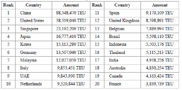
Table 1.3 refers to container traffic volumes of top 20 countries in 2010. The highest numbers of container exist in China. The next one is United States with the amount of 38.5 million TEU which is less than half amount of China.
10
Tab.1.3 Container Traffic Volumes (CHO and YANG, 2011;161).
Figure 1.4 refers to world container traffics yearly (million TEUs). The crisis in 2009 is obviously found in figure 1.4. The highest amount of world container traffic was 500 million TEU till 2009.
11 2.2 INTERMODAL TRANSPORT UNIT (ITU)
Intermodal transport unit (ITU) is a term that defines different types of units that load goods. The ITUs parts are containers, swap bodies, semi-trailers and roll-on frame.
The most common ITU types are shown schematically in the below figure.
Fig.1.5 Intermodal Transport Unit Types
2.2.1 Container
Container is a transportation unit which transports goods easily without loading or discharging during transportation procedure.
The different between container and swap body is that each container can be top-lifted and stacked one on the other but this characteristic does not exists swap body. The size of main unit is 6.10 and 12.20 meters (20 and 40 feet) and they are normally used for rail forwarding and Lo-Lo shipping. In shipping sector for measuring capacity and movements TEU is used which is equal to twenty foot equivalent units (Woxenius, Kania and Podsiadly , 2006;3).
12
Some types of containers are dry freight containers, refrigerator containers, open top containers and flat-rack containers.
2.2.2 Swap Bodies
Swap bodies are used in European countries for an intermodal/multimodal transportation purpose. For national movements, As long as the sizes of trucks are different, the containers should be standards and fit for them.
The sizes of normal swap bodies are 7.15; 7.45 or 7.82 mt. Some companies have different size of containers also. Due to the inadequate legs they are not very harmonious with Ro-Ro shipping
2.2.3 Semi-Trailers
The size of semi-trailer is 13.6 meters. Road transportation companies commonly use semi-trailers. Also Ferry and Ro-Ro ports used them a lot.
2.2.4 Roll-on Frame
Usually Roll-on/roll-off containers are used for waste in order to receive, store and transport them. In roll-on frame activity the container is not covered that's why it's not safety regarding to its design.
2.3 UNACCOMPANIED TRANSPORT
The most common forms of transport are containers, swap bodies and semi-trailers. In the most countries unaccompanied transport has 80 percent of market share in which only the loading units are transported by rail. Transport of maritime containers which include inland rails has 90% market share in the most countries of the world.
13
In order to make unaccompanied transport some details are needed which are technical, organizational and infrastructure preparations. For unaccompanied transport in road haulage and freight forwarders mobile or gantry crane should be used. This activity is called vertical transshipment. The normal vehicles are cheaper than road vehicles with swap bodies and semi-trailers. A haulier duty is to get the container from the origin and transferred to the final destination. Many transportation companies improve their activities by managing their own offices and finding trustworthy partners (Focus on Combined Transport, 1995; 4).
Figure 1.6 shows an example of unaccompanied transport.
Fig. 1.6: Unaccompanied Transport
(http://www.hupac.ch/index.php?node=333&lng=2&rif=fc18cbf50c; 10.03.2014)
2.4 ROLLING ROAD (ROLA) - ACCOMPANIED COMBINED TRANSPORT
Ro-La transportation system is a process in which transport road vehicles (trucks) on trains including low-floor wagons. On transportation procedure the drivers stay in their couchettes.
The trucks are transferred in terminals thought mobile ramps. The vehicles should have specific requirements applicable to the category.
14
The advantages of RO-LA system is that it is too easy and quick to load and unload. It is quite convenient especially in situations that require rapid delivery and it is suitable for the distances between 200-400 km transportation. Figure 1.7 refers to rolling road system.
Fig. 1.7 Rolling Road (RO-LA)
(http://www.sbbcargo-international.com/en/rolling-highway-rola.html; 20.02.2014)
2.5 ROLL ON, ROLL OFF (RO-RO) SHIPPING
Ro-Ro is a shortening of "roll on, roll off". Ro-Ro procedure is about the transportation vehicles and machinery by huge ocean ships. Roll-on/roll-off (RORO or ro-ro) ships are produced for transporting wheeled cargo like automobiles, trucks, semi-trailer trucks, trailers, and railroad cars without using handling operation. This procedure is opposite of lift-on/lift-off (LOLO) vessels that is using for crane to handling (Sorgenfrei, 2013; 34).
In RO-RO vessels there are doors that can be open and close so they can be used as ramps for cargos in order to be load and discharge simply at ports. There are smaller ferries that also have built in ramps which move across rivers and other short distances but the term RO-RO usually could be used for larger oceangoing vessels. The ramps and doors may be stern-only, or bow and stern for quick loading. Picture 1.1 refers to type of RO-RO shipping system.
15
Picture 1.1: RO-RO Shipping (http://aaronpb.com/?page_id=33;10.03.2014)
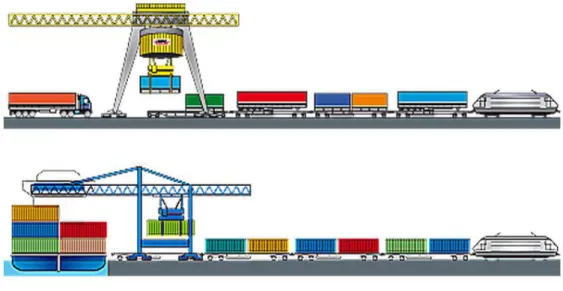
2.6 PIGGYBACK TRANSPORTATION
Piggyback transportation is a kind of transportation in which has two types. one of them is trailers on flatcars (TOFC), the other one is containers in flatcars (COFC) . This transportation is on railways. Moreover in double-stack transportation two containers at the same time place loaded onto one flatcar (train). The usage of double-stack transportation is; increasing the operating efficiency and reducing the cost per container (Coyle, 2003; 212).
According to figure 1.8 piggyback transportation include two types. One of them is side by side on the train. The other type is double stack. In double stack one container located on the top of the other one.
16
Fig. 1.8 Piggyback Transportation (Coyle, 2003; 212).
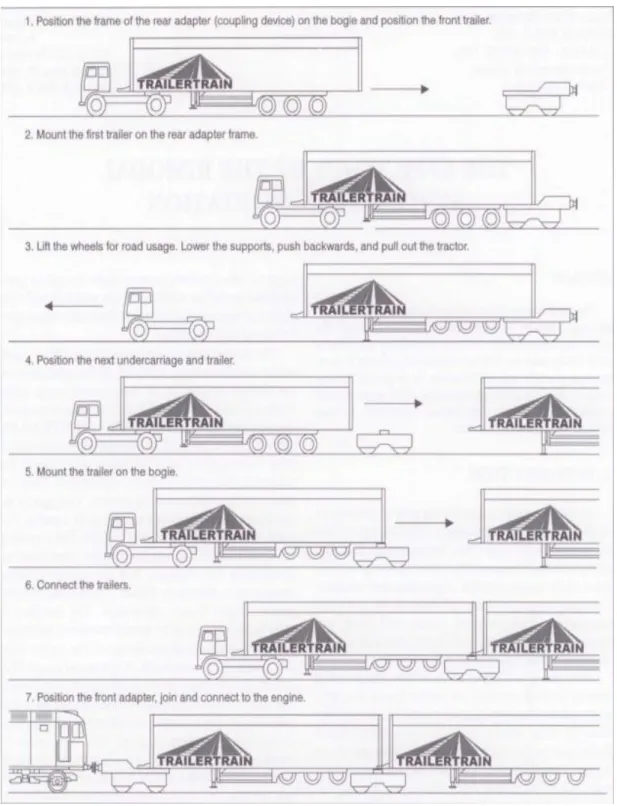
2.7 BI-MODAL TRANSPORTATION-ROADRAILER
Bimodal transport is a kind of transportation that cargo is being load on pallets or containers which are load on road-railway or ship. This procedure is not related to the cargo handling objects.
Bimodal transportation has advantages is transporting without needing any special handling process and built terminals in between railway and road (Strumberger, 1998; 89).
In the majority of minor railway stations there are paved parts of tracks as well as auxiliary tracks which provide the necessary space for handling manipulations from road to railway and vice versa.
Bimodal system is a procedure between trailer and train as shown in the figure blow. Part I: Position the frame of the rear adapter on the bogie and position the front trailer.
17
Part III: Lift the wheels for road usage. Lower the supports, push backwards, and pull out the tractor.
Part IV: Position the next undercarriage and trailer. Part V: Mount the trailer on the bogie.
Part VI: Connect the trailers.
18
19 2.8 TRAIN FERRY TRANSPORTATION
A train ferry is a ship that has a rail on it is body for train. This shipping mode looks like RO-RO. The railway vehicle enters to ship and transfers to the other destination. Train ferry provides transportation without any handling operation.
Picture 1.2 is about train ferry organizations.
Picture 1.2 Train-Ferry Organizations
(http://www.ukrferry.com/eng/vessels/vessel-geroi-plevny; 10.03.2014)
2.9 LIFT-ON/LIFT-OFF (LO/LO)
Lo-Lo vessel (Lift on - Lift Off) is used for shipping extraordinary cargos. It has flexible cargo space and onboard cranes. In this mode of transportation handling equipment is used for loading and discharging. Lo-Lo transportation system gives services by its own cranes at port. In the other transportation systems cranes are at the port.
20
In roll on-roll off (Ro-Ro) transportation, the transporter vehicle enters to the ship that why there is no need to handling operation and less labor is used comparing to lift on-lift off (Lo-Lo) . But lift on-lift off (Lo-Lo) cannot handle the type of cargoes which are like bulks (Cambridge Systematic, 2004; 9).
Deep sea ports are not suitable for short time freight operations. The primary customers of deep sea ports are ocean-going vessels. All the equipments of deep sea ports are designed and set up for ocean-going vessels. Lift-on/lift-off (lo-lo) cargo handling systems are frequently used on ships or boats which transport containers in short distances sea operations. In Lo-Lo ship there are special equipment and specialized labor for loading and discharging (Kruse, 2010; 71). The needed time for loading and discharging of Lo-Lo ships is 12 hours. But the port gives 24 hours in case.
The ships have kinds of cargo handling equipment. The most popular systems are Lo-Lo and Ro-Ro. (Even the ships have been known Lo-Lo or Ro-Ro vessels). Every ship and cargo handling equipment has services for special goods. Also each of them has their own advantages and disadvantages regarding to their cost and service policy. If the technology matches to port infrastructure, market of goods and labor limitation would have huge effect on the operation economics.
Some lo-lo vessels is a type of vessel that is self-geared vessels. These vessels have deck-mounted handling cranes because of this the capacity decreases. Some times when there are not enough cranes in the ports, the vessel-mounted cranes are used instead (http://www.globalsecurity.org/military/systems/ship/lo-lo.htm;10.03.2014).
21
Pic.1.3 Lo-Lo Operations (Source: http://www.tgal.us/lift-on-lift-off-shipping;10.03.2014)
22
3. INTERMODAL TRANSPORTATĠON NETWORK
3.1 TRANS-EUROPEAN TRANSPORT NETWORKS (TEN-T)
In 2013 the Trans-European transport network (TEN-T) new legal basis was accepted. It includes transport infrastructure policy in Europe. some researchers has been done regarding the combined multi-modal network in the past 20 years, accordingly combined multi-modal network shows the main innovation of the new TEN-T policy. Until 2030 this network should be improved. Trans-European transport network (TEN-T) connects main points through rail, road, inland waterway, maritime and air transport connections (European Commission, 2014; 5).
The most significant role about applying of the new TEN-T policy is main network corridors. TEN-T includes three main routes. These are border connectivity and reducing strait barriers, to shipping modes to each other and improving technical interoperability.
In order to actualize the goals for Europe, a strong basis project establishment and network improvement. All standards all set for networks, existing parts and planned parts suitable for EU legislation.
The existing standards are informing new railway policy, transport telematics and security. The new TEN-T policies are about improving "green" transport and innovative issues. This policy is about connection between TEN-T and urban mobility and high-quality services for freight and passengers.
These policies are;
One of the most important issues is setting the connection between networks. Maritime ports and airports as Europe's gateways, inland ports and rail road terminals are going to connect and make an intermodal transportation chain to deliver goods from origin to destination.
23
In new corridors they decided to respond to future needs of mobility, support efficiency of resources, lower carbon emissions for sustainable transport solutions (http://ec.europa.eu/transport/themes/infrastructure/ten-t-guidelines/transport
policy/index_en.htm ;17.03.2014).
Trans-European network infrastructure development is closely related with executing and progress of EU transport policy.
3.1.1 Corridors
European Commission
In order to facilitate the coordinated use of core network, core network corridors were explained. They connect together public and private resources and focus on EU support from the Connecting Europe Facility (CEF), especially to:
remove bottlenecks,
remove lack of cross-border connections and Improve modal integration and interoperability. They also aim at:
connecting rail transportation corridors,
support environmental fuel
other innovative shipping solutions,
advancing telematics applications for efficient infrastructure use, integrating urban areas into the TEN-T,
increasing safety.
There are 9 corridors includes different kind of projects that are eligible to get EU funding in the period of 2014 and 2020. These projects are according to Connecting Europe Facility (CEF) regulation they are as added value of TEN-T and factor that develop it.
Connecting Europe Facility helps to improve TEN-T network. Amount of 26 billion EUR budget it considered to perform this project. In order to reach competitor
24
Europe and sustainable European network all the stakeholders are cooperating (European Commission, 2014; 6).
In order to understand that corridors are effectively and efficiently developed each of them should be direct by a European Coordinator patronage by a consultative forum.
Below we can find the explanation of nine core network corridors:
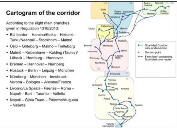
The Scandinavian-Mediterranean Corridor; is a significant north-south route for economy of Europe. The Scandinavian-Mediterranean Corridor which is longest corridor of TEN-T core networks begins in Russia border and passes through Helsinki, Stockholm and Malmö to the continent of Europe. In this corridor Nuremberg is the center point between eastern and western side. The corridor includes some parts of Italian cities. These are Bologna, Rome, Naples, Geneva and also last station is Sicily in Italy. This corridor includes sea-way options, for example the connection between Sicily and Malta. The main goal of this project is Fehmarnbelt crossing and Brenner base tunnel that include access routes
(http://ec.europa.eu/transport/themes/infrastructure/ten-t-guidelines/corridors/index_en.htm; 17.03.2014).
According to figure 2.1 Scandinavian-Mediterranean corridors, sub-corridors and connection are shown including the situation of connections and details. For example Hamina-Kotka–Helsinki sub corridor has port interconnections, rail upgrading and icebreaking capacities.
25
Fig. 2.1 Scandinavian - Mediterranean Corridor Map (Ramboll, 2014; 2)
The North Sea-Baltic Corridor; starts from Tallinn continue to Riga, Kaunas, Warszawa, Berlin, Hannover and ends Amsterdam. This supports an availability of Baltic Sea and North Sea. It connects Finland with Estonia by ferry and supports rail and road connection between Poland, Germany, the Netherlands and Belgium on the other. Mittelland-Kanal refers to inland waterways which connects Odra River and German, Dutch and Flemish ports. The main goal of this project is European standard railway connection of Tallinn, Riga, Kaunas and North-Eastern Poland.
Below there is a list of pre-identified project of Connecting Europe Facility (CEF). For example Tallinn-Riga-Kaunas-Warszawa rail connections. International Union of Railways (UIC) is working in order to improve interoperable line. The line starts to give service before 2020. This line is going to be an airports, ports and rail-road terminal connection.
26
Tab.2.1 North Sea-Baltic Corridor Pre-Identified Projects (European Commission, 2013)
27
The North Sea-Mediterranean Corridor; starts from Ireland and the north of United Kingdom to Netherlands and Luxembourg continue to the Mediterranean Sea in the south of France. This corridor has also inland waterways for interconnecting British island and Europe (http://ec.europa.eu/transport/themes/infrastructure/ten-tguidelines/corridors/index_en.htm; 17.03.2014).
In table 2.2 pre-identified project of Connecting Europe Facility (CEF) is shown. Tab.2.2 North Sea-Mediterranean Corridor Pre-Identified Projects (European Commission, 2013).
28
Adriatic corridor; the most critical north-south corridor of Europe is Baltic-Adriatic corridor. It stretches from Poland, continues to Czech Republic, Slovakia, Austria and Italy. The critical issue of this corridor is the connections from hinterland of Baltic and Adriatic (Austrian Ministry for Transport Innovation and Technology, 2009; 2).
Map 2.1 shows Baltic-Adriatic rail and road corridors map
Map 2.1 Baltic-Adriatic Corridors (European Commission; 2013)
The Orient/East-Med Corridor; The corridor that connects maritime interfaces of the North, Baltic, Black and Mediterranean Seas is The Orient/East-Med Corridor which supports the availability of ports and accordingly the Motorways of the Sea. This corridor has Elbe inland waterway that can support the multimodal connections between Northern Germany, the Czech Republic, the Pannonia region and Southeast Europe. It passes from the sea through Greece to Cyprus.
29 In this corridor main routes are;
Hamburg – Berlin
Rostock – Berlin – Dresden
Bremerhaven/Wilhelmshaven – Magdeburg – Dresden Dresden – Ústí nad Labem – Melnik/Praha - Kolin
Kolin – Pardubice – Brno – Wien/Bratislava – Budapest – Arad – TimiĢoara – Craiova – Calafat – Vidin – Sofia
Sofia – Plovdiv – Burgas Plovdiv – TR border
Sofia – Thessaloniki – Athina – Piraeus – Lemesos – Lefkosia Athina – Patra/Igoumenitsa
This corridor has too many missing links. Exactly region of Hungary, Bulgaria, Romania and Greece have to improve about this topic. And also this corridor exists in land of high traffic flows. Especially border crossing will access easily and rail
and inland waterway should be improved for
connectivity(http://ec.europa.eu/transport/themes/infrastructure/ten-tguidelines/corridors/doc/orient_east_med.pdf ; 19.03.2014).
30
Map.2.2 Orient/East-Med Corridor (Neubaustrecke Dresden-Prag, 2011; 2)
The Rhine-Alpine Corridor; is the busiest transportation corridors in Europe. This corridor starts from North Sea in Amsterdam and ends in Mediterranean Sea in Genoa. The Rhine-Alpine Corridor has also inland waterway. The main projects are based on tunnels in Switzerland to receive corridors in Germany and Italy
(http://ec.europa.eu/transport/themes/infrastructure/ten-t-guidelines/corridors/index_en.htm;17.03.2014).
The map 2.3 shows Rhine-Alpine Corridor and sub corridors. The corridor starts Amsterdam and ends in Genoa. In this corridor the distance between Rotterdam to Genoa is 1.400 km. And also the distance between Genoa to Zeebrugge is 1.500 km.
31
The total corridor lines are 3.900 km. Rhine- Alpine corridors have 6 sea ports, 10 inland ports and 100 main terminal facilities. Expected growth of rail freight on the corridor would be doubled till 2020.
Map 2.3 Rhine-Alpine Corridor Map (International Corridor Rhine-Alpine Conference 2014; 2)
The Atlantic Rail Corridor; is running between Atlantic coastal areas. The corridors pass from Portugal, Spain, France, Ireland, Belgium, the Netherlands, Germany, Denmark, Sweden and Norway.
To the East it connects with the Lyon, Ljubljana, Budapest axis up to the Ukrainian border (Kiev), and with the Berlin, Warsaw axis up to the Byelorussian border (Minsk) (Atlantic Rail Corridor Development, t.y; 1).
32
The whole cargo which goes through Atlantic corridor is addressed to more than 80 million inhabitants (That is 25% of the population of Euro zone). These cargos are distributed between Lisbon, Madrid, Paris, Brussels, The Hague, London, Dublin and Berlin in stack of more than one million inhabitants.
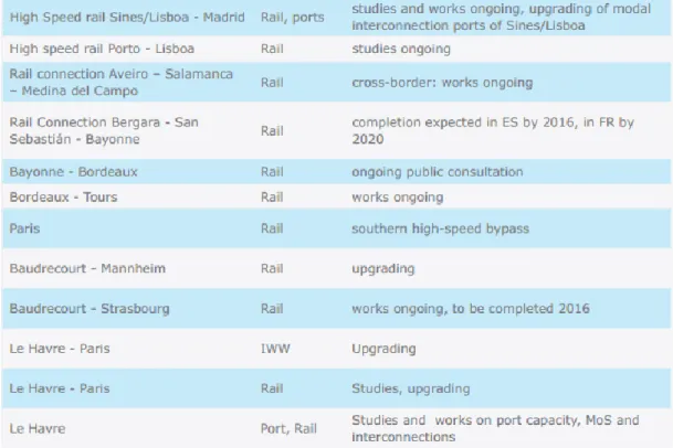
Table 2.3 shows connections between main terminals and connection types. For example from Bordeaux to Tours rail transportation is used. And also in some sub corridors the constructions update are continuing.
Tab.2.3 Atlantic Corridor Pre-Identified Projects (European Commission, 2013)
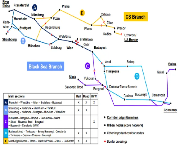
The Rhine-Danube Corridor; Such as understood from the name The Rhine-Danube Corridor is located in Rhine and Danube rivers. The corridor connects the central areas of Strasbourg and Frankfurt continues to Southern Germany to Vienna, Bratislava, Budapest and lastly the Black Sea.
33
Figure 2.2 shows Rhine-Danube corridor. As we can seen in figure the corridors starts from Frankfurt follows Danube River and finally ends in Constanta. This figure includes 5 main corridors. The sub corridor which starts from Frankfurt and ends in Budapest is a complex of rail, road and inland waterways. Also as it is shown in the figure 2.2 we can recognize how many different types of transportation exist in sub corridors.
Fig.2.2 Rhine-Danube Corridor (IWW refers inland waterways) (Hacon, 2014; 65)
The Mediterranean Corridor; connects south-western Mediterranean areas, continues to Spain and France coastlines and fits in the Alps and reaches to Italy (European Coordinators, 2014; 36).
The Mediterranean Corridor include these cities; Algeciras – Bobadilla –Madrid – Zaragoza – Tarragona - Sevilla – Bobadilla – Murcia - Cartagena – Murcia – Valencia – Tarragona – Barcelona – Perpignan – Marseille/Lyon – Torino – Novara
34
– Milano – Verona – Padova – Venezia – Ravenna/Trieste/Koper - Ljubljana – Budapest - Ljubljana/Rijeka – Zagreb – Budapest – UA border.
Table 2.4 shows connections between sub corridors and connection types. For example between Algeciras to Madrid the railway construction is continuing and it would be finish in 2020.
35
Tab.2.4 Mediterranean Corridor Pre-Identified Projects (European Commision; 2013)
36
Map 2.4 TEN-T CORE NETWORK
37
3.2 PAN-EUROPEAN TRANSPORTATION NETWORK
Three Pan-European Transport conferences have been talked about Pan-European Transport Network and improved it. The first Pan-European Transport conference was held in Prague in 1991. The concept for transport infrastructure was agreed in this conference.
The second Pan-European Transport conference was held in 1994 in Crete. In this conference they discussed about infrastructure improvement for the countries of Western, Central and Eastern Europe. Also nine long distance transport corridors were mentioned.
Third European Transport conference was about tenth corridor and the Pan-European Transport Areas for maritime basins were added. This conference was held in Helsinki in June 1997.
The Helsinki Corridor is approximately 48.000 km. this corridor is a multi modal corridor. 25.000 km of it is railway and 23.000 km road network. For Central and Eastern European countries the long distance interconnection are airports, sea- and river ports and major terminals (European Commission Dg Energy & Transport, 2002; 6).
Pan-European Transport Infrastructure Investment Partnership supports the enterprise of all essential parts for future Pan-European Transport Network. This partnership is going to give this help to European countries and candidate countries (European Commission Dg Energy & Transport, 2002; 6).
In table 2.5 we can see the details about corridors that pass cities and railways and road length.
38
Tab.2.5 Pan-European Corridors (Source: the details taken from European Commission)
39 3.2.1 Corridor I
Corridor I is between North - South route. Multi-modal transportation is possible in this corridor. It begins from Helsinki (Finland) and connects Tallinn (Estonia), Riga (Latvia) and Kaunas (Lithuania) with Warszawa (Poland) and Gdansk (Poland).
Corridor I includes the following three components;
1. The road Corridor starts from Tallinn to the Latvian metropolis Riga. From Riga the Corridor passes Kaunas (Lithuania) and crosses the Lithuanian / Polish border at Kalvarija / Budzisko and ends in Warszawa.
2. The rail Corridor starts from Tallinn through Tartu and ends in Riga . It crosses the Latvian border at Meitene/Kalviai and continues to Siauliai and Kaunas (Lithuania). The railway crosses the Lithuanian/Polish Border at Mockava/Trakiszki keeps going on, then southwest to Warszawa.
3. The branch of Corridor I run in Riga (Latvia) and then thought Kaliningrad (Russia) to Gdansk (Poland). The road branch crosses the Lithuanian/Russian border at Panemune/Pagegiai running to Kaliningrad (Russia). After that the road passes the Russian/Polish border at Grzechotki and ends in Gdansk (Poland).
The railway of Corridor I cross the Lithuanian/Russian border at Pagegiai goes on to Kaliningrad and to the Russian border Mamonovo and terminates in Gdansk (European Commission Dg Energy & Transport, 2002; 34).
In this corridor concerned countries are Finland, Estonia, Latvia, Lithuania, Poland and Russia. This corridor includes all of transportation modes without pipeline. The length of railways is 1,655 km and roads are 1,630 km. 6 airports and 11 ports exist in this corridor.
40 3.2.2 Corridor II
Corridor II is a multi-modal East–West link connecting Berlin - Warszawa - Minsk - Moscow and Nizhny Novgorod. This corridor is a road railway combination going parallel with links cities. The distance from Berlin to Nizhny Novgorod is 2,313 km by rail and 2,260 km by road.
In Helsinki Conference it was decided to lengthening corridor II from Moscow in 1997. The access to the inland waterways in Russia is given by the extension along the Volga River to the Caspian Sea and via the Volga/Don Canal to the Sea of Azov and the Black Sea.
Road and rail route stretches Berlin, Warsaw, Minsk, Moscow and Nizhny. Polish segments are taken large investment of routes. Rehabilitation and upgrading of motorway in the Belarus and Russian segment are needed, together with technical modernization and administrative improvement of border crossings, which still suffer long delays (Emerson, 2009; 34).
3.2.3 Corridor III
The Ukrainian road segments ( two lane highways) do not yet meet European standards and the delays at border crossing into Ukraine are substantial (4-5 hours). Some European Bank for reconstruction and development funding is being made available.
The table 2.6 shows technical features of corridor III. A corridor passes from Germany, Poland and Ukraine. In this corridors railways, roads, aviation and seaways exist. In table 2.6 corridors III includes 1.650 km railways, 1.700 km roads networks and also 4 airports and 9 ports exist.
41
Tab.2.6 Technical Features Of Corridor III (European Commission Dg Energy & Transport, 2002; 43).
3.2.4 Corridor IV
Corridor IV passes from Austria, Bulgaria, Czech Republic, Germany, Greece, Hungary, Romania, Slovakia, and Turkey. This corridor includes all transportation types without pipeline. The length of railways in this corridor is 4,340 km and roads are 3,640 km. there is no inland waterways in this corridor but there are 8 ports and 10 airports.
305 km rail connection of corridor IV starts from Turkish/Bulgarian border (Kapikule) to Edirne and ends in Istanbul (Sirkeci). 277 km are single-track however the total length is electrified. A new railway hub is going to be built in Halkalı. The train which used this corridor can reach Asian side by passing Marmaray project.
A multi-modal Northwest - Southeast shipping routes start from Dresden/Nurnberg (Germany), through Prague (Czech Republic), Wien (Austria)/Bratislava (Slovakia), Budapest (Hungary) to Romania.
42 3.2.5 Corridor V
Bosnia Herzegovina, Croatia, Italy, Hungary, Ukraine, Slovakia and Slovenia are a part of corridor V. The total length of railways is 3,270 km in corridor V. The longest railway is 585 km which is in Bratislava/ Slovakia. The longest road is 588 km in Hungarian/Slovenian. Also total length of road is 2,850 km in this corridor. There are 5 airport and 3 ports. All transportation selections exist in corridor V.
This corridor is connected to Venezia and Trieste ports in Italy. There is a place in Slovenia named Divaca which has a connection between Koper port and Corridor V. In Budapest the corridor divides two branches, both of them goes to the Adriatic Sea. one sub corridor continues to Rijeka in Croatia, the other sub corridor continues to Sarajevo (Bosnia-Herzegovina) (European Commission Dg Energy & Transport, 2002; 68).
Between Slovenia and Hungary there was a missing part on this corridor railway part (European Commission Dg Energy & Transport, 2002; 68).
3.2.6 Corridor VI
This corridor consists of railway lines with a length of 1800 km and roads with a length of 1,880 km.This corridor has a connection with corridor V. Corridor VI is a multi-modal corridor which starts from Brno/Czech Republic through Warszawa and ends in Gdańsk port. This corridor has benefit of connecting the Polish Baltic Sea ports of Gdańsk with Slovakia and the Czech Republic.
43
Map 2.5 Pan-European Corridor VI (source; map/google.com)
According to the Map 2.5 we can see two main routes in Poland. Corridor VI stars from Gdańsk port in Poland. Gdańsk port is the main port for Baltic Sea because of two main branches running from this port. One of them is going to Warszawa and ends in Martin in Slovakia. The other branch is going to Katowice through the border of Czestoshnowa which is in Czech Republic. Finally this branch reaches to Brno city.
Poland is the main city of Corridor VI. Corridor VI has a length of 1,559 km railways and 1,447 km of roads in Poland.
44 3.2.7 Corridor VII
The Danube Corridor is a connection that links East-West it is one of three European corridors. There are three different transportation modes in Austria, Bavaria and Hungary. Corridor infrastructure generally is bimodal (road and railway) but in Bavaria, Austria and Hungary it has tri-modal (road, railway and inland waterway). The East-West Danube Corridor, close to Vienna and Bratislava links to Baltic-Adriatic corridor. By this connection the Danube Corridor subscribes integration of Europe (Logistikum, 2010; 13).
In 1997, regarding to the conclusion of 3rd Pan-European Transport Conference of Helsinki this corridor denotes:
• The Danube inland waterway, • The Black Sea-Danube Canal,
• The Danube branches Kilia and Sulina,
• The inland waterway links between the Black Sea and the Danube, • The Danube – Sava canal,
• The Danube – Thissa canal, and
• The about port infrastructures place on these inland waterways (European Commission Dg Energy & Transport, 2002; 80).
3.2.8 Corridor VIII
Another multimodal corridor is Corridor VIII which is passing from East to West in south-eastern Europe. This corridor connects Pan-European Transport Area Adriatic-Ionian Sea with the Black Sea Pan-European Transport Area. The Corridor starts at the port of Durrës, runs via Tirana and Skopje, further to Sofia and to the Bulgarian ports Burgas and Varna at the Black Sea (European Commission Dg Energy & Transport, 2002; 87).
The Corridor goes through three countries, which are Albania, Bulgaria and Macedonia. Four transportation types exist in this corridor; railways, roads, air
45
transportation and seaways. The railway length is 1,270 km, road length is 960 km. Also 4 airports and 2 ports exist in Corridor VIII.
3.2.9 Corridor IX
As we know there are ten Pan-European multi-modal Transport Corridors, the longest is Corridor IX. Railway length of this corridor is 6,500 km and roadway length is 5,820 km. It starts from Helsinki, goes to St. Petersburg. There it divides to two parts; one of them goes to Moscow, the other one goes to Pskov. In Kiev both parts meet together. In Rozdilna the Corridor splits again.
The connection between Helsinki, St. Petersburg, Pskov/Moscow, Kiev, Ljubasevka, Chisinau, Bucharest, Dimitrovgrad, Alexandroupolis is road and railway. The infrastructure development is already done but because of managerial problems at border crossing road and rail traffic is increasing (Checchi , 2009 ; 35).
3.2.10 Corridor X
This corridor was decided to perform in order to empower peace period of Former Federal Republic of Yugoslavia in 1997 at Helsinki. It passes through Pan-European Transport Motorway North–South and according to the traditional road its goes to South Eastern Europe and the Balkans (Cerovski, 2004; 5).
The main axis is connected to the following cities or areas via four branches:
• Graz (Austria) – Maribor (Slovenia) – Zagreb (Croatia);
• Budapest (Hungary) – Novi Sad (Yugoslavia) – Beograd (Yugoslavia);
• Nis (Yugoslavia) – Sofija (Bulgaria) and further along Corridor IV to Istanbul; • Veles (Macedonia) – Bitola (Macedonia) – Florina (Greece) and further via Florina – Kozani (via Egnatia) to Igoumenitsa. (Status of the Pan-European Transport Corridors and Transport Areas; European Commission Dg Energy & Transport; 2002; 108)
46
Below there is a map of developed Pan-European corridors.