Contents lists available atScienceDirect
Energy Strategy Reviews
journal homepage:www.elsevier.com/locate/esrExploring the o
ffshore wind energy potential of Turkey based on
multi-criteria site selection
Mehmet Argin
a, Volkan Yerci
b, Nuh Erdogan
c, Sadik Kucuksari
d,∗, Umit Cali
e aEngineering Department, Houston Community College, Houston, TX, USAbSelcuk University, Konya, Turkey
cMarine and Renewable Energy Centre, University College Cork, Cork, Ireland dDepartment of Technology, University of Northern Iowa, Cedar Falls, IA, USA
eDepartment of Engineering Technology and Construction Management, University of North Carolina at Charlotte, NC, USA
A R T I C L E I N F O
Keywords:
Offshore wind energy potential Offshore wind farm Site selection Wind energy Turkey
A B S T R A C T
Wind energy is the leading form of non-hydro renewable energy source in terms of installed capacity in Turkey. It is among the most promising option for Turkey to decrease the energy dependence of external primary energy resources such as national gas and oil that diversifies the domestic share of energy sources in the national energy mix. However, offshore wind energy deployment has not gained satisfactory attention even though the country is surrounded by seas on three of its sides. Exploring Turkey's offshore wind power potential becomes an important task to serve this energy policy. This study presents a methodological framework forfinding the most suitable offshore wind farm locations, meeting various multi-layer site selection criteria. The offshore wind energy re-source isfirst assessed using the wind energy potential for 55 coastal regions where the nearshore meteorological stations are available in Turkey. Following on this analysis, a multi-criteria site selection work is carried out to identify the most suitable areas for offshore wind development. Wind Atlas Analysis and Application Program (WAsP) is then used to conduct statistical analysis to identify the most promising offshore wind farm locations. According to the pre-processing step of the framework, Bozcaada, Bandirma, Gokceada, Inebolu, and Samandag coastlines are found to be the most suitable locations for offshore wind farm development. Finally, the offshore wind energy potential of Turkey is estimated by using the micro-sitting configuration of wind turbines, con-sidering sea depth, main wind direction, and distance to shore for the most feasible project locations. It is found that total estimated offshore wind power capacity at the specified sites is 1,629 MW.
1. Introduction
Global decrease of fossil resources and ever increasing environ-mental concerns caused a dramatic increase in the research on alter-native energy sources in the last two decades. In addition to growing energy need along with the growth of world population and in-dustrialization, the demand for more economic and more en-vironmentally friendly energy production has driven to the use of re-newable energy resources such as wind and solar. Accordingly, developed countries have provided billion $ grants and incentives for the development and proliferation of renewable energy technologies. They have built their national renewable energy action plans and put into place to reach the targets associated with use of energy from re-newable resources [1]. This worldwide trend can play a vital role to reduce fossil fuel dependency of the global energy mix, which in turn
reduce CO2emissions and help the decarbonisation of the energy sector
[2]. Among various renewable energy resources, wind energy has been a leading form of renewable energy in terms of installed capacity [3]. As of end of 2017, global installed wind power accounts for about 51% of the total renewable power capacity excluding conventional renew-able hydropower [4]. Global cumulative installed wind power capacity has increased from 17.4 GW in 2000 to 539 GW at the end of 2017 [5]. The use of wind energy is just as likely to increase in coming years as the technology is being competitive [6].
In the growing wind energy market, offshore wind energy is be-coming prominent due to restrictions of land availability for onshore installations [7]. Annual cumulative offshore wind power capacity has increased triple fold in the last 5 years, resulting in the accumulated capacity reaching 14.384 GW [5]. European countries are leading the world with over a cumulative installed offshore wind power capacity of
https://doi.org/10.1016/j.esr.2018.12.005
Received 26 March 2018; Received in revised form 17 October 2018; Accepted 6 December 2018
∗Corresponding author.
E-mail addresses:[email protected](M. Argin),[email protected](V. Yerci),[email protected](N. Erdogan), [email protected](S. Kucuksari),[email protected](U. Cali).
Available online 17 December 2018
2211-467X/ © 2018 Elsevier Ltd. This is an open access article under the CC BY-NC-ND license (http://creativecommons.org/licenses/BY-NC-ND/4.0/).
T
12 GW in which the UK is the top country in terms of offshore installed capacity. The US and China also projected installed offshore wind power capacity of 22 GW by 2020 and 30 GW by 2030, respectively [8,9]. Compared to onshore regions, offshore regions have lower roughness in terms of wind surface, resulting in higher wind speed and wind power density. However, the main barrier to the massive pro-liferation of offshore wind turbines is high capital and operational costs including the expenses related to the logistics over a life cycle [10,11]. As the wind energy technology develops, a significant cost reduction could be achieved in the offshore wind sector in coming years to take advantage of its potential.
Turkey is one of the key emerging countries in the G20. The energy demand is rapidly increasing due to its economic development and growing population. In terms of the total installed power capacity, it is in the top 6 countries in Europe and in the top 20 countries in the world [5]. As of end of 2017, the total electricity production and installed capacity are 297.277 GWh and 85.2 GW, respectively [12]. The dis-tribution of the produced electricity in terms of primary energy sources is as follow. Natural gas 32.5%, coal 33.6%, hydropower 24.5%, wind 5.7%, geothermal 1.8% and other (oil, biomass, solar) 1.9% [12]. Turkey is extremely dependent on natural gas imports, especially for electric power generation. The total imported natural gas amount in 2015 was 1.71 billion cubic feet [13]. The aggressive pursuit of re-newable energy resources is therefore indispensable to reduce the country's dependence on oil and natural gas imports. Among all re-newable energy sources, wind energy is promising in Turkey thanks to its geographical location. According to the data provided by Turkish State Meteorological Service (TSMS), the annual average wind speed is 2.58 (m/s) with the wind power density of 25.8 (W/m2) at 10 m [14].
Considering only wind speed and water depth of 50 m, Malkoc [15] roughly estimates theoretical offshore wind energy potential of Turkey as 10.5 GW for the regions in wind classes higher than 4 (m/s). In Ref. [16], the technical wind power potential of Turkey is estimated to be 83 GW which ranks Turkey as the highest wind power potential country among the countries in the European Organization for Economic Co-operation and Development. This awareness has shaped Turkey's en-ergy policy over the past decade. Accordingly, the Renewable Enen-ergy Law was introduced in 2005 and revised several times to encourage and regulate the installations [17]. The policies have boosted the use of wind energy in the last decade, resulting in a wind electricity produc-tion of 11.6 million kWh by the end of 2015 [12]. However, the use of wind energy is still not satisfactory and can be further increased to meet the energy demand when considered high technical wind power po-tential. In addition, the wind speed spatial map of Turkey for offshore locations does not currently exist. As a result, the offshore wind power potential has not been explored yet.
This study presents a multistage scheme forfinding the most sui-table offshore wind farm locations in Turkey among the 55 coastal re-gions, including their technical power capacities. A multi-criteria site selection (MCSS) analysis is performed by considering technical (e.g., wind speed and sea depth), social and civil restrictions, i.e., territorial waters, military areas, civil aviation, shipping and pipeline routes, en-vironmental concerns. Based on available coastal wind speed data, the most applicable offshore sites are first determined. Then, a cascaded MCSS analysis is performed by assessing each predetermined site ac-cording to the restrictions pertaining to the studied area. Using the WAsP software [18], Weibull distributions of the wind speed are ex-tracted for the selected locations. In thefinal stage, considering the sea depth of 45 m, main wind direction, and the distance to shore, the micro-sitting analysis is performed to identify the number of wind turbines and their configurations. The rest of this paper is organized as follows. Section II reviews the research conducted on the wind energy potential of Turkey and the multi-criteria decision analysis used in the assessment of offshore wind power locations. Section III introduces the site description and the methodology used including the implementa-tion of the proposed site selecimplementa-tion criteria. Results and discussion are
presented in Section IV. Finally, Section V provides the concluding re-marks.
2. Literature review
The studies conducted on wind energy in Turkey can be classified into two groups [9–20]. Thefirst group overviews wind energy devel-opments in Turkey [14,17,19–21]. Based on the data by the Turkish National Committee of the World Energy Council, thefindings reveal that annual average wind speed in Turkey varies from the lowest value of 2.1 (m/s) with a wind power density of 13.19 (W/m2) in East Ana-tolia region, to the highest value of 3.3 (m/s) with a wind power density of 52 (W/m2) in Marmara region [22]. Between the years of 2008 and
2013, the installed wind energy capacity increased 7 folds, reaching total capacity of 2,958 MW. Thirty percent of total wind energy capa-city has been installed in the coastal regions of Turkey by the end of 2015 [22]. The second group studies investigate the wind energy po-tential using statistical methods for various regions of Turkey [22–27]. In these studies, Weibull distributions are used to determine the wind energy potential. The studies used monthly or annual average wind speed data to obtain wind speed complete frequency distributions. The study in Ref. [23] showed that the wind density at a height of 25 m above the ground level in the south-eastern Mediterranean region is about 500 (W/m2) which makes the area convenient for wind energy system installations. Eskin et al. [24] extrapolate the collected wind speed data at heights of 10–30 m to 50 m for Gokceada Island. It was found that the wind speed varies from 7 (m/s) to 11 (m/s) at the height of 50 m. Another study [25] investigates six locations in central and eastern Anatolia region. It was found that the cities of Erzurum and Elazig in the eastern Anatolia region have the highest wind power density of 65 (W/m2) and 62 (W/m2), respectively. Wind energy po-tential in coastal regions of Turkey is studied in Refs. [22,26]. Among 12 coastal stations investigated, Marmara region's coastal areas are found to be the most promising for wind energy system installations [26]. IlKilic et al. [22] showed that coasts of Marmara and Aegean sea have the highest wind energy potential with an annual average wind speed of 6.9 (m/s) at the height of 50 m. It is further found that East Mediterranean and Western Black Sea coasts with an annual average wind speed of 6.4 (m/s) are the following best potential areas. Majority of the existing wind energy potential studies in Turkey concentrate on the onshore wind power potential of Turkey. Moreover, the studies consider only Weibull distributions of wind speed data particularly pertaining to the studied coastal area and disregard the location re-strictions that decrease to use its wind power potential. Argin and Yerci in Ref. [27] investigated the feasibility of coastal regions for offshore wind energy system installations earlier as a preliminary study. It is shown that some part of Aegean and Marmara sea coasts (e.g. Ca-nakkale, Gemlik, Datca) are not applicable for offshore wind energy system installations even though the regions have above average wind speed (e.g.,>3.0 (m/s)) due to civil restrictions (e.g., territorial waters and shipping routes). The study is also restricted to broad investigation of offshore locations.
The multi-criteria decision analysis (MCDA) methods have been the main research stream in the assessment of offshore wind farm locations since the assessment incorporates numerous criteria in its nature [28–32]. Among possible methods such as the Preference Ranking Or-ganization Method for Enrichment Evaluation (Promethee), Electre etc., analytical hierarchy process (AHP) is one of the most popular MCDA methods involving both qualitative and quantitative evaluation criteria in sustainable energy development planning [32]. A methodology for choosing the location of an offshore wind farm is proposed in Ref. [28]. The set of options is evaluated in terms of various aspects (e.g., spatial, economic and social and environmental aspects) under numerous sub criteria. Based on their priority and expert judgment, the criteria are relatively weighted by using the AHP method while the Promethee II method is applied for ranking decision options. In Ref. [30], to solve a
decision-making problem of determining an offshore wind farm loca-tion among four decision oploca-tions, Ziemba et al. proposed an improved Promethee method, where the measure of mean absolute deviation extended by the weights of criteria is used. It was shown in Ref. [30] that the improved method provides a lower degree of criteria com-pensation with more stable and less sensitive to changes in the criteria weights as compared to the Promethee counterpart even though both methods give the same offshore location as the most sustainable option. For the same problem, Salabun et al. in Ref. [29] proposes a fuzzy based model which is independent of decision options. The uncertainty and imprecision of input data regarding variants characteristics have an impact on the subjectivity of the assessment. A fuzzy MCDA method is therefore developed in Ref. [31] to present uncertainties and impreci-sion appearing in deciimpreci-sion problems.
Eligible offshore sitting locations have not been identified yet in Turkey. This study aims to explore all optimal offshore location sites and calculate their wind power potential rather than ranking possible sites for the decision making purpose. In this task, most of the criteria in assessing the locations in terms of various perspectives (technical, en-vironmental, and social-economical) are considered equally in a cas-caded way, each of which cannot be opt out for another. However, majority of MCDA methods employed in the literature include deriva-tion of priority vectors for relatively weighted criteria, implementaderiva-tion of those by using numerical values, and ranking of decision options based on the evaluation criteria. Therefore, the ranking possible sites with an evaluation through weighted criteria may not be feasible in mapping large scale offshore wind power potential atlases.
3. Site selection
3.1. Methodology
Turkey is located between Europe and Asia and covers 780,000 km2
land area. Turkey has rich offshore areas as the country is surrounded by three seaside, namely Black Sea, Mediterranean Sea, and Aegean Sea. In addition, Marmara Sea is located within the country borders. However, due to its strategic location that brings special coastal se-curity and being so close to neighbor country's sea territorials, special and detailed analysis is needed to estimate the offshore wind energy capacity of Turkey.
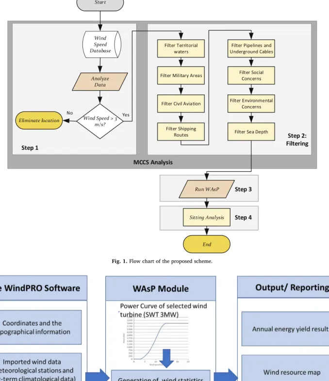
The methodology for site selection of offshore wind farm and ca-pacity includes mainly four steps some of which are studied manually by paying detail attention. The historical wind data is used and ana-lyzed to find suitable locations. Extensive and careful study is per-formed to estimate the maximum possible wind power output. Thefirst step as expected is the wind speed analysis. Since there is no available offshore wind speed data to the researchers, the data collected at the nearby onshore meteorological stations are used in this study. The wind speeds in possible offshore locations are estimated based on the avail-able onshore data. The second step mainly includesfiltering of locations with substantial wind speed by combining several selection criteria that are going to be explained in detail in the next section. The offshore area meeting all the criterion after filtering is proceeded as the potential wind farm location. The third step is the use of WAsP software to conduct statistical analysis of hourly wind speed data for the potential areas. The fourth and last step is the wind farm sitting analysis (micro-siting) where the number of turbines, their exact locations, and con-figuration are identified. The flow chart inFig. 1shows the proposed scheme in detail and explanations of each step are given in the fol-lowing subsections.
WindPRO is one of the most popular wind modeling software used to design and analyze offshore and onshore wind farms [33]. First, the coordinates and topographical maps of the projected area, wind data (wind measurements from metrological stations and climatological data), roughness, and height contour maps information are inserted to the system. WAsP (Wind Atlas Analysis and Application Program) is one
of the essential modules which is used as an internal calculation engine within the WindPRO software to calculate the energy values [18]. In this study, WAsP 11.2 student version is used to conduct statistical analysis of hourly wind speed data. As summarized inFig. 2, WindPRO and WAsP combine the power curve of the projected wind turbine (e.g., SWT 3.0) with the annual wind speed distribution for each offshore wind location to estimate the annual wind energy yield and other re-lated wind resource assessment analysis results. Turbines with a rated power of 3 MW are considered in the wind farm design since this tur-bine capacity is currently a typical commercial configuration and it is also supported by WindPRO. Wind array losses are also calculated using the inserted information. Using the module outputs, the highest mean wind speed and mean power density of the locations are identified.
This paper is thefirst attempt to mapping the offshore wind power potential of Turkey among the 55 coastal regions. This work is an ex-ante estimate that uses the available data such as wind speed, geo-graphic concerns, and public perceptions, considering various criterion without any priorities. This study has been largely limited by the data used. As such, there is no offshore specific measurements available. It is assumed that the collected data at nearby onshore meteorological sta-tions are accurate, and the oceanography data are up to date and pre-cise. All of the aforementioned constraints add some level of un-certainty into the analysis as well.
3.2. Wind potential analysis (Steps 1 and 3)
To have wind energy systems technically and economically viable, wind farms are installed on higher wind speed potential areas. Accurate and reliable wind data is essential for a potential wind energy assess-ment of the selected site. General Directorate of Renewable Energy and TSMS are the government agencies in Turkey providing wind data in-formation. In this study, wind speed and direction data for 55 coastal sites in Turkey, provided by TSMS are used. Locations with wind speed of more than 3 (m/s) are considered. The provided data are based on measurements made at the height of 10 m on an hourly basis at the respective nearshore meteorology stations. In addition, due to the lack of 10 years of measurement at certain locations, the data includes measurements for 5–10 years in some locations. Unfortunately, none of the measurements belongs to offshore sites due to a lack of offshore meteorology stations in Turkey. Consequently, offshore wind energy potential assessment are made based on onshore wind data measured at the closest nearby onshore meteorology station. It is obvious that the actual wind speed at offshore is higher than the speed at the coastal side.
Since the provided data include measurements at the height of only 10 m, the wind speed, V, (m/s) for various heights can be calculated by (1) as follows: = ⋅⎛ ⎝ ⎞ ⎠ V V h 10 , α 0 (1) where, V and V0are the wind speed (m/s) at height h and 10 m, re-spectively. h is the height (m) corresponding to V (m/s).α refers surface roughness coefficient, which is chosen as 0.12 for terrain data since the assessments are made for smooth sea surface for offshore sites [34]. 3.3. Offshore wind farm site selection criteria (Step 2)
Site selection is key to the success of offshore wind farm projects both economically and technically. Primary investigation of restricted areas is required. Depending on the area properties, the perspectives may include but are not limited to oil and gas extraction, military ex-ercise areas, underwater cables, harbor entrances and navigation routes, environmental restrictions, aquaculture, sand and gravel ex-traction, marine archaeology sites, landscape and seascape as public heritage, offshore renewable energy projects already installed in the region of interest and the relevant characteristics (water depth, distance
to shore, distance to operation and maintenance base, seabed geology, social and regulatory issues, safety) of the area [35,36].
Considering the conditions of seas in Turkey, an offshore site must be primarily suitable in terms of wind speed, territorial waters, military
areas, civil aviation, maritime traffic, pipelines, and underground cables routes [37,38]. In addition, relatively minor environmental and social concerns such as noise and visual impact of wind farms, dis-placement of birds and mammals may place restrictions on offshore Fig. 1. Flow chart of the proposed scheme.
Fig. 2. Wind resource assessment using windPRO and WAsP.
wind farm site [39]. Many other limitations such as the location of oil and gas platforms and mining zones that are not applicable for Turkey are usually considered in other countries in the identification of wind farm site. The following sections explain the details of the applicable criteria that are used in this study.
3.3.1. Territorial waters
According to international law [40], territorial waters is defined as the area of the sea immediately adjacent to the shores of a state and they are subject to the territorial jurisdiction of that state. The current width of territorial waters protected in treaty law by the United Nations Convention on the Law of the Sea of 1982 (Art.3) is 12 nautical miles (∼ 22 km). Turkeys territorial water in the Aegean Sea is very narrow due to the close proximity of Greek islands. At present, both countries keep 6 nautical miles (∼ 11 km) off their shores in the Aegean Sea. However, the territorial waters at some locations are reduced to one nautical miles or less. This criterion is not a concern for Black Sea and Mediterranean Sea sides because of being far from neighbor countries.
3.3.2. Military areas
Some seas and lands are used by the military for training purposes, thus these areas are restricted for other uses. Military areas consist of trainingfields, naval restricted zones, and naval special security zones. The Military often uses open areas with low population density and raise concerns about possible wind farms effect on aviation. There has been always a conflict between the expansion of wind farms and mili-tary areas. Therefore, the restrictions imposed by the milimili-tary compli-cates the installation of economically feasible wind farms [41].
3.3.3. Civil aviation
Noise generated by wind farms leads to complications in radar systems. In some countries, additional funds are allocated to support research on reducing the harmful effects of wind farms on radar sys-tems. In UK, Memorandum of Understanding was signed in 2008 be-tween the wind and aviation industries with the Government to over-come these issues. Aircrafts take-off and landing points should also be taken into consideration when making site selection decision for the offshore wind farm as restrictions may be imposed within a certain distance.
3.3.4. Shipping routes
Due to increased demand for offshore wind farms, shipping routes have become the main issue especially in most of the developed countries. Studies have been conducted on marine spatial planning for effective use of coastal areas [42,43]. The economic impact of changing vessel routes on offshore wind projects has also been investigated as wind power industry is increasingly pushing government agencies for more space [44]. There is still an argument between stakeholders be-cause of the use of coastal areas. Thus, a detailed analysis must be made before selecting the site of the offshore wind farm in terms of shipping routes.
3.3.5. Pipelines and underground cables
Pipelines and underground cables should not be exposed to any damages occurring from wind farms in the short and long term. Mariners should avoid anchoring, dredging or trawling in 500 m vici-nity of submarine cables and natural gas pipeline since it is dangerous and prohibited [45].
3.3.6. Social concerns
Visual impact and noise arising from wind farms are the two major concerns while installing offshore wind farms. The structureless land-scape of wind turbines may cause visual disturbance. However, the visual impact of offshore wind farms can be minimized by locating the turbines away from coastlines. Noise arising from wind farms can be audible up to 1 km and thus can be problematic for residents living
nearby, as a result, leads to public opposition for wind energy projects. Although this is relatively a minor problem for most of the offshore wind farms, by installing wind turbines properly and keeping reason-able distance to nearby residents, noise problem can be significantly reduced for offshore wind farms [39].
3.3.7. Environmental concerns
Environmental concerns due to heavy use of fossil fuels is one of the major driving force for growth of renewable energy sources including wind power. However, recent developments in wind energy industry have raised other environmental concerns on biodiversity. In Europe, there is very strong legislative framework to balance wind energy de-velopment with nature conservation. Any dede-velopment causing adverse effect is subject to an appropriate impact assessment.
The impacts include collision risks, barrier effect, displacement, habitat loss or degradation. Birds and bats have a risk of colliding with wind turbine components. Wind farms are considered to force birds to change theirflight direction. Birds and marine animals may relocate from their habitats due to visual, noise and vibration impact arising from wind farms. Depending on the size of the wind farm, habitat loss varies. In developed countries, Strategic Environmental Assessments including sensitivity mapping at the regional or national level are used to identify available and restricted zones for wind farm development [39].
3.3.8. Sea depth
Installing offshore wind turbines requires special attention on sea soil properties, sea depth, and wave heights since the turbine founda-tions need to be secured. Sea depth is one technical criteri on that mainly affects the cost of turbine installation. The foundation cost is almost tripled for an increase in depth from 10-20 m to 40–50 m. The offshore wind turbine installations in Europe have an average sea depth of 20 m and 22.4 m in 2013 and 2014, respectively. In terms of eco-nomically viability of offshore wind farms, sea depth is currently taken as 50 m in Ref. [46]. In this study, the sea depth of 45 m is selected as a selection criteri on for sitting the wind turbines.
3.4. Sitting analysis (Step 4)
After identifying the exact site location and its borders through the above-mentioned criteria, the next step is micro-sitting configuration of wind turbinesfitted carefully into the proposed area. The total number of turbines, and so the total power capacity, depends on how efficient the turbines are sited. The distances between the turbines play a critical role on the efficiency and power output of a wind farm since the wind speed cannot be efficiently used as some of its energy is extracted by the wind turbine blades. The rules-of-thumb for tower spacing for a rec-tangular area is 3–5 rotor diameter (D) spacing between towers within a row and 5D-9D between rows [47]. The turbines used in this study have a rotor diameter of 100 m. The designed offshore wind farm consists of 5D tower spacing in a row, while 9-10D spacing between rows is se-lected depending on the availability of the specified site. This micro-siting configuration is selected to fit maximum available installed ca-pacity within the proposed project aerial.
In addition to the turbine spacing criterion, the main wind direction is considered for the specific location on identifying the turbine number and sitting. The WAsP analysis provides the main wind direction. The wind farm layout is prepared by positioning the location of the in-dividual wind turbine by considering the main wind direction. Optimum micro-siting is an essential step to minimize the array losses in wind energy projects. The distance to shore is also considered for both defining the area and siting the turbines since the closeness is part of the social and environmental concerns. In this study, the nearest distance of turbines to shore varies from 150 m to 335 m, while the farthest distance of turbines varies from 1225 m to 7360 m. During this analysis, distribution plots and nautical charts are used for accurate
sitting.
4. Results
4.1. Wind speed analysis and site selection (Steps 1 and 2)
As thefirst step, the wind speed of locations is analyzed. Hourly mean wind speed for the studied coastal regions is provided inFig. 3. As shown in thefigure, considering the mean wind speed of higher than 3 (m/s), only eleven offshore locations (i.e., Bozcaada, Amasra, Sa-mandag, Gokceada, Inebolu, Canakkale, Bandirma, Gemlik, Datca, Aliaga, and Karasu) among the 55 locations are considerable for wind farm installation. These 11 coastal regions are shown on the map of Turkey (Fig. 4).
As the second step, the suitability of selected locations are assessed through the aforementioned criteria as follows:
1 First, the suitability of eleven regions for offshore wind farm de-velopment in terms of territorial waters is analyzed. Regions on the
Black Sea, Marmara Sea and the Mediterranean Sea do not have territorial water issues since the width of territorial waters is high with neighbor countries. Therefore, Samandag, Gemlik, Bandirma, Amasra, Karasu, and Inebolu can be considered for offshore wind farm development. However, Gokceada, Bozcaada, Canakkale, Aliaga, and Datca are by the Aegean Sea, thus, territorial waters criterion must be taken into account for wind farm installation due to their close proximity to Greek territorial waters [48]. Based on the detailed analysis of thesefive shores, it is found that there are relatively less areas for offshore wind farm installations at Aliaga and Datca. Particularly, Turkish territorial waters surrounding Datca is very limited due to close proximity to Greek territory. In clusion, Datca is considered as an unsuitable while Aliaga is con-sidered as partially suitable sites in terms of territorials water. 2 Second, each of the selected locations is analyzed in terms of the
military restrictions criterion. There are several training and shooting zones in Black Sea region. In Amasra region, the restricted zone is within the 15 miles radius of Amasra coastal sides. Thus, Amasra cannot be considered for offshore wind farm development. On the Fig. 3. Hourly mean wind speed of coastal regions at 10 m.
Fig. 4. Suitable installation locations for offshore wind energy systems based on wind speed (The map is adapted from Ref. [27]).
other hand, there are no military zones on the sea within close proximity of Karasu and Inebolu, therefore, these two locations are suitable for offshore wind farm development. Marmara Sea has training and shooting zones. There is a shooting zone on the northeast side of Bandirma, but it is far from any possible wind farm development zone. There is also military training zone covering the entrance of Gemlik bay that may limit the wind farm installations. Similar zones exist in the Aegean Sea. Particularly, military zones surrounding Canakkale makes it very difficult to consider offshore wind farm installations on the north-west side of Canakkale. Aliaga has also a special security zone by its coast, hence its shores have restrictions in terms of offshore wind farm development [45]. Military zones around Bozcaada and Gokceada, are not an issue since possible sea surface is available for wind farm installation. Datca bay and Samandag is free from any military restrictions. 3 Third, when assessing the selected locations in terms of civil aviation,
there is no close by the airport in any of eleven locations based on aircrafts take-off and landing routes, provided through the Directorate General of Civil Aviation [49]. However, there are he-licopter and small aircraft landing points on or by the sea at Gemlik, and Datca. With multiple landing points on the sea, Datca appears to have more difficulties due to a lesser area in the sea for wind turbine installations. In addition, possible installed wind farms may also increase noise effect on radar systems for the aircraft landing points. 4 Fourth, major shipping routes in Turkey is identified from Ref. [27]. These shipping routes are not very close to proposed coastal regions thus, it does not become a major concern for offshore wind system development in many regions. However, the Dardanelles pass at
Canakkale is the main route for maritime traffic, hence it is not suitable for offshore wind farm construction. In addition, Aliaga has a heavy maritime traffic as well due to the presence of petrochem-ical refinery and many ship s dismantling facilities. Gemlik bay in Marmara region has a high volume of shipping routes due to Gemlik port located at a very narrow bay in the region. Therefore, Gemlik appears to be not suitable for offshore wind system.
5 Most of the natural gas and petroleum pipelines in Turkey are going through the land and not too many on the coastline. There is not any pipeline nearby the proposed coastal regions except the Canakkale, which is already a restricted zone in terms shipping route criterion. Considering public opposition on the location of wind farms, Datca bay may be of concern. Datca is a touristic area and wind farms may cause visual impact since turbines must be located very close to the land due to limited territorial waters. Most importantly, Datca area is a protected zone according to Forestry and Water Affairs Ministry in Turkey that brings additional concerns for the wind farm devel-opment. There is a protected zone for carettas at the south-west side of Samandag that makes it partially suitable in terms of environ-mental concerns.
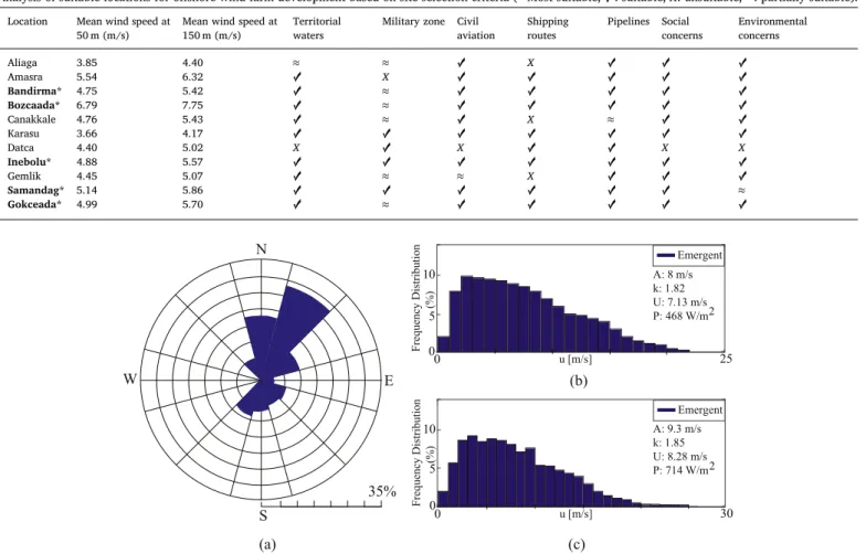
In conclusion, the above-mentioned criteria analysis for selected eleven locations is summarized inTable 1. The wind speed values are calculated based on Eq. (1). It is shown that the shores of Amasra cannot be considered for offshore wind systems due to military training zones in spite of its high wind power potential. Canakkale and Gemlik shores have many restrictions due to military areas, shipping route etc. Datca bay cannot also be considered for offshore wind farm Table 1
Analysis of suitable locations for offshore wind farm development based on site selection criteria (* Most suitable, ✓: suitable, X: unsuitable, ≈: partially suitable).
Location Mean wind speed at 50 m (m/s)
Mean wind speed at 150 m (m/s)
Territorial waters
Military zone Civil aviation Shipping routes Pipelines Social concerns Environmental concerns Aliaga 3.85 4.40 ≈ ≈ ✓ X ✓ ✓ ✓ Amasra 5.54 6.32 ✓ X ✓ ✓ ✓ ✓ ✓ Bandirma* 4.75 5.42 ✓ ≈ ✓ ✓ ✓ ✓ ✓ Bozcaada* 6.79 7.75 ✓ ≈ ✓ ✓ ✓ ✓ ✓ Canakkale 4.76 5.43 ✓ ≈ ✓ X ≈ ✓ ✓ Karasu 3.66 4.17 ✓ ✓ ✓ ✓ ✓ ✓ ✓ Datca 4.40 5.02 X ✓ X ✓ ✓ X X Inebolu* 4.88 5.57 ✓ ✓ ✓ ✓ ✓ ✓ ✓ Gemlik 4.45 5.07 ✓ ≈ ≈ X ✓ ✓ ✓ Samandag* 5.14 5.86 ✓ ✓ ✓ ✓ ✓ ✓ ≈ Gokceada* 4.99 5.70 ✓ ≈ ✓ ✓ ✓ ✓ ✓
Fig. 5. WAsP analysis for Bozcaada a) frequencies (%) of wind direction b) frequency distribution of wind speed at 50 m c) frequency distribution of wind speed at 150 m.
development due to being a protected zone, civil aviation-related is-sues, and visual impacts. Aliaga becomes infeasible due to the military special security zone and heavy maritime traffic. Karasu meets all of the criteria. However, its mean wind speed is low for feasible offshore wind farm development. In conclusion, thefive locations, namely, Bozcaada, Bandirma, Gokceada, Inebolu, and Samandag coastal regions, are pro-mising for offshore wind systems in Turkey.
4.2. Siting analysis for selected regions (Steps 3 and 4)
Thefive suitable locations indicated inTable 1are considered for the WAsP and siting analysis. Bozcaada is an island located at the northeast of Aegean Sea and 12 miles south of Canakkale. Currently,
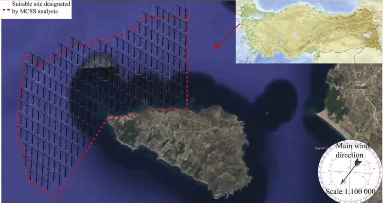
there is only one onshore wind farm located at the west of Bozcaada Island with a capacity of 10.2 MW [50]. WAsP analysis conducted for Bozcaada at 50 and 150 m are shown inFig. 5. The mean wind speed at 50 and 150 m varies between 7.13 (m/s) and 8.28 (m/s) respectively while the wind power density at 50 and 150 m ranges from 468 (W/m2)
to 714 (W/m2), respectively. The wind blows from northeast to southwest.Fig. 6shows the proposed wind farm site at Bozcaada shores and the sitting of wind turbines. The northwest shores of Bozcaada is primarily chosen as the suitable location due to shallow waters. In addition, this area is selected to capture maximum wind power po-tential based on the main wind direction as given inFig. 5. The selected area does not interfer with the military areas border and Greek terri-torial waters. The number of wind turbines is determined based on the Fig. 6. The selected site and sitting of wind turbines at Bozcaada shores (The map is adapted from Google Maps).
Fig. 7. WAsP analysis for Bandirma a) frequencies (%) of wind direction b) frequency distribution of wind speed at 50 m c) frequency distribution of wind speed at 150 m.
actual blade size, distances between the turbines and the available surface area of the decided site. The total number of turbines is cal-culated as 223 that can be located within the selected area with a maximum power generation of 669 MW. The closest and farthest tur-bines are situated at 335 m and 7359 m from the coastline, respectively. Bandirma is located at the south of Marmara Sea. There have been nine onshore wind farms with the total installed capacity of 359.4 MW [50]. The WAsP analysis conducted for Bandirma at 50 and 150 m are shown inFig. 7. The mean wind speed at 50 and 150 m varies between 5.09 (m/s) and 5.93 (m/s) respectively, while the wind power density at 50 and 150 m ranges from 219 (W/m2) to 346 (W/m2), respectively. The wind direction is from northeast to southwest as inFig. 7.Fig. 8 shows the proposed wind farm site at Bandirma shores and the sitting of wind turbines. The northeast shores of Bandirma is chosen for wind farm installation due to more availability of sea space since the other sides of the sea in Bandirma shores are restricted by the military area and shipping route. The total number of turbines is calculated as 97 that can be sited within the selected area with a maximum power generation of 291 MW. The closest and farthest turbines are placed at 301 m and 6639 m from the coastline, respectively.
Gokceada is the biggest island of Turkey and located at the north of
Aegean Sea and west of Canakkale. There is currently no onshore wind farm installed at Gokceada. The WAsP analysis results are shown in Fig. 9. The mean wind speed at 50 and 150 m varies between 5.17 (m/s) and 6.04 (m/s) respectively, while the wind power density at 50 and 150 m ranges from 211 (W/m2) to 337 (W/m2), respectively. As seen in
Fig. 9a, the wind directions are primarily from the northeast to the southwest and from the north to the south.Fig. 10shows the proposed wind farm site at Gokceada shores and the sitting of wind turbines. When considering the sea depth of 45 m restriction, relatively small area on the east shores of Gokceada can be used. The area is bordered by military restricted zone on the north-east side and restricted by the diving zone on the south-west side of the island. The selected area can host 74 turbines with a maximum power generation of 222 MW. The closest and farthest turbines are situated at 155 m and 3623 m from the coastline, respectively.
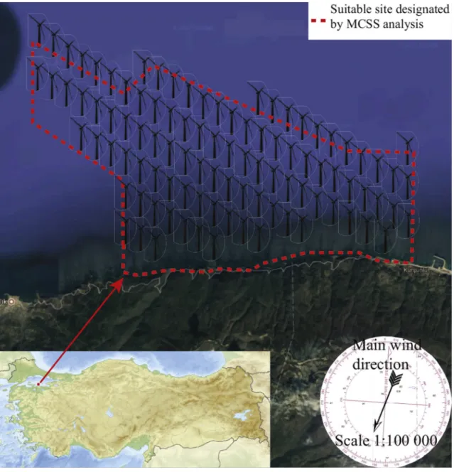
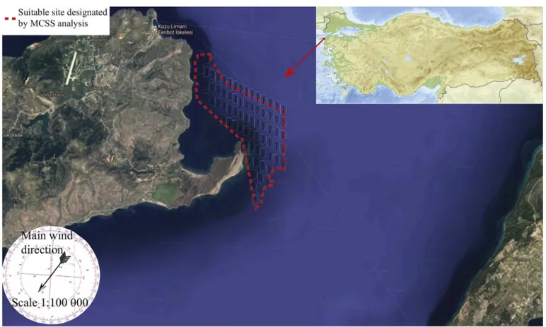
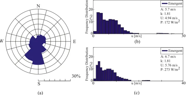
Inebolu is located at northern Turkey and the south of Black Sea. At present, there is no onshore wind farm located at Inebolu. WAsP ana-lysis conducted for Inebolu at 50 and 150 m are shown inFig. 11. The mean wind speed at 50 and 150 m varies between 4.94 (m/s) and 5.76 (m/s), respectively, while the wind power density 50 m and 150 m ranges from 172 (W/m2) to 273 (W/m2) at 50 and 150 m, respectively.
As seen inFig. 11a, the wind directions are primarily from the south to the north and from the southwest to the north east.Fig. 12shows the proposed wind farm site at Inebolu shores and the sitting of wind tur-bines. Almost entire sea space by Inebolu coastline can be used for wind farm installation, as there are not any restrictions in the area. The total number of 92 turbines can be installed in the selected area with a maximum power generation of 276 MW. The closest and farthest tur-bines are situated at 307 m and 1930 m from the coastline, respectively. Samandag is located at the southeast of Mediterranean Sea. There
are currently four onshore wind farms installed with capacities ranging from 11 MW to 63.7 MW, and the total installed capacity is 163,7 MW [50]. WAsP analysis conducted for Samandag at 50 and 150 m are shown inFig. 13. The mean wind speed at 50 and 150 m varies between 5.27 (m/s) and 6.16 (m/s) respectively while the wind power density at 50 and 150 m ranges from 154 (W/m2) to 245 (W/m2), respectively. As
shown inFig. 13, the wind mainly blows from the north-east to the south-west and the south-west to the north-east.
Fig. 14shows proposed wind farm site at Samandag shores, and the Fig. 9. WAsP analysis for Gokceada a) frequencies (%) of wind direction b) frequency distribution of wind speed at 50 m c) frequency distribution of wind speed at 150 m.
Fig. 10. The selected site and sitting of wind turbines at Gokceada shores (The map is adapted from Google Maps).
sitting of wind turbines. The north-west side of Samandag is chosen for wind farm installation since there is a protected zone for carettas at the south-west side of Samandag that makes wind farm installation im-practical. The designed wind farm consists of 9D spacing between rows unlike the turbines with 10D row spacing sit in other four sites. The total number of turbines is calculated as 57 with a maximum power generation of 171 MW. The closest and farthest turbines are situated at 175 m and 1225 m from the coastline, respectively.
The designed offshore wind farms for the most suitable coastal re-gions are summarized inTable 2. The total offshore wind power ca-pacity of Turkey is calculated as 1.62 GW. As reported in the table, Bozcaada is the best region for offshore wind farm development. It has the highest wind speed with 9.3 (m/s) at 150 m. In addition, thanks to
shallow waters at the selected site, more turbines can be installed within 45 m sea depth. Thus, a wind farm with a maximum power ca-pacity of 669 MW can be installed in the selected site. There seems to be less visual impact concern due to lack of residential settlement at Bozcaada across proposed offshore wind farm. The total amount of power generated (669 MW) requires a new substation construction. In addition, the cost of power transmission to the mainland of Turkey may also be expensive due to the high cost of underground cable installa-tions for 25–30 km distance to the mainland. This is also the case for Gokceada.
In addition to Bozcaada, Bandirma and Inebolu are also promising for offshore wind systems with a maximum wind power capacities 291 MW and 276 MW, respectively. Public concern may be of interest at Fig. 11. (a) WAsP analysis for Inebolu a) frequencies (%) of wind direction b) frequency distribution of wind speed at 50 m c) frequency distribution of wind speed at 150 m.
Inebolu, because the turbines are installed just nearby the shore (45 m away from to the land). Similar to Bozcaada case, relatively shallow water in the selected site of Bandirma allows installing more turbines away from the shores preventing possible visual impact concern. Compared to Bozcaada case, however, the power transmission cost seems to be relatively lower due to close proximity to the land. Samandag has the lowest offshore wind power capacity among selected five regions within the sea depth of 45 m, even though the wind speed is the second highest. However, the close locations of designed turbines to the land may limit power transmission costs making offshore wind farm installation feasible in Samandag.
5. Conclusion and future studies
In this paper, offshore wind farm site locations of Turkey have been explored through wind energy potential assessment of 55 coastal re-gions. First, suitability of regions with average wind speed over 3 (m/s) is assessed. Second, the MCSS method has been used tofind the best suitable locations. Finally, statistical analysis of wind speed for the lo-cations meeting the MCSS is conducted using the WAsP software. In addition, micro-sitting configuration of wind turbines is determined considering the sea depth of 45 m, main wind direction, and the dis-tance to shore. The analysis of the results yields the following conclu-sions:
•
Although three fourth of Turkey are surrounded by sea, out of 55 coastal regions, only 11 regions including Bozcaada, Amasra, Samandag, Gokceada, Inebolu, Canakkale, Bandirma, Gemlik, Datca, Aliaga, and Karasu are considerable for offshore wind farm installation as the mean wind speed at selected sites is higher than 3 (m/s). In addition, some sites with high wind speed ratio are still not eligible for installations due to the restrictions resulting from their geographically strategic location such as military zones, shipping routes, civil aviation, touristic places, etc.•
Sites that do not meet offshore wind farm site selection criteria: The shores of Amasra cannot be considered for offshore wind power systems due to restricted military training zones even though high wind speeds exist in the location. Canakkale, Datca, and Gemlik have many restrictions that do not meet the location selection cri-teria, thus, the regions are not suitable for offshore wind systems. Due to a military special security zone and a heavy maritime trafficat Aliaga, a detailed investigation must be made together with na-tional army forces to prevent any possible problem for offshore wind farm development. Karasu meets all of the criteria, but wind speed is still low for feasible offshore wind farm development.
•
Suitable sites: based on proposed MCSS analysis, Bozcaada, Bandirma, Gokceada, Inebolu, and Samandag coastline are the most suitable locations for offshore wind farm development. Bozcaada has the highest wind power potential with a total capacity of 669 MW, while Samandag has the lowest with a total capacity of 171 MW. The total offshore wind power capacity is estimated to be 1,629 MW that corresponds to approximately 30% of the current installed wind power capacity of Turkey. Thisfinding indicates that studies about offshore wind farm installation should be accelerated in Turkey.•
This study used the wind speed data collected at the coastal regions. It is obvious that offshore meteorology station installations are needed to better assess offshore wind power potential. Hence, it is recommended that the policy makers shall organize offshore specific measurement campaigns to increase the reliability of future offshore related studies.•
As the offshore wind industry develops, the economics might change, which in turn make marginal sites more feasible. However, based on the current data, the specified sites as reported in this study should provide a starting point for examining where offshore wind farms could be installed.•
Besides the offshore wind resource assessment studies, other off-shore renewable energy resources can be investigated in an in-tegrative way.The presented study will be further extended with the techno-eco-nomic feasibility analysis of the selected offshore sites to investigate the economic viability of the future offshore wind farms. As such, this work will consider technical findings from this study, state of the art in-vestment, operational and maintenance cost values of the typical o ff-shore wind farms, local incentives, and other realisticfinancial factors. A part of this work has been carried out in parallel with the presented study and can be found in Ref. [51]. In addition, the sea basement analysis has to be carefully investigated because the soil structure af-fects the cost of turbine installations. The transmission and distribution of the generated wind power is another issue that needs to be taken special attention. Some of the selected locations in this study are the Fig. 13. WAsP analysis for Samandag a) frequencies (%) of wind direction b) frequency distribution of wind speed at 50 m c) frequency distribution of wind speed at 150 m.
islands which may have not a close substation at the coastal side. Therefore, possible substation installation on the coastal side should be taken into consideration both in technical and economic analysis. As a more precise site selection analysis, more accurate offshore wind data can be collected for offshore locations, and careful sea depth and soil analyses can be performed. Collaborating with government agencies, more up to date policy information can be obtained. Based on the collected data, priorities can be set and weighted to be used in other
modern numerical analysis methods for multi-criteria decision such as MCDA. Finally, possible collaboration with the neighboring country, Greece, on installing offshore wind farms may lead to the use of higher offshore wind power potential in the Aegean Sea.
Acknowledgment
The authors would like to acknowledge Turkish State Fig. 14. The selected site and sitting of wind turbines at Samandag shores (The map is adapted from Google Maps).
Table 2
The designed offshore wind systems for the most suitable coastal regions of Turkey.
Location Mean wind speed at 50 m (m/s)
Mean wind speed at 150 m (m/s) Number of turbines Total capacity (MW) Tower spacing in a row Tower spacing between rows
Distance of the closest turbine to the shore (m)
Distance of the farthest turbine to the shore (m)
Bozcaada 7.13 8.28 223 669 5D 10D 335 7360
Bandirma 5.09 5.93 97 291 5D 10D 300 6640
Inebolu 4.94 5.76 92 276 5D 10D 300 1930
Gokceada 5.17 6.04 74 222 5D 10D 150 3620
Meteorological Service (TSMS) and Turkish Office of Navigation, Hydrography and Oceanography for providing data and maps, and Denmark Technical University (DTU) Wind Energy group for providing WAsP software.
References
[1] S. Szab, A.J. Waldau, M. Szab, F. Monforti-Ferrario, L. Szab, H. Ossenbrink, European renewable government policies versus model predictions, Energy Strateg. Rev. 2 (3) (2014) 257–264.
[2] T.L. Afonso, A.C. Marques, J.A. Fuinhas, Strategies to make renewable energy sources compatible with economic growth, Energy Strateg. Rev. 18 (2017) 121–126.
[3] R. Saidur, M. Islam, N. Rahim, K. Solangi, A review on global wind energy policy, Renew. Sustain. Energy Rev. 14 (7) (2010) 1744–1762.
[4] R. E. P. N. for the 21st Century (REN21).
[5] Global wind energy council (GWEC), Global wind statistic. URLhttp://www.gwec. net.
[6] C. P, et al., European decarbonisation pathways under alternative technological and policy choices: a multi-model analysis, Energy Strateg. Rev. 2 (3) (2014) 231–245. [7] X. Sun, D. Huang, G. Wu, The current state of offshore wind energy technology
development, Energy 41 (1) (2012) 298–312.
[8] U.S. Department of Energy, U.S. Department of Interior, National offshore wind strategy, URL, 2016.https://www.boem.gov/National-Offshore-Wind-Strategy/. [9] X.-g. Zhao, L.-z. Ren, Focus on the development of offshore wind power in China:
has the golden period come? Renew. Energy 81 (2015) 644–657.
[10] T. Poulsen, C.B. Hasager, How expensive is expensive enough? opportunities for cost reductions in offshore wind energy logistics, Energies 9 (6) (2016) 437. [11] R. Dawid, D. McMillan, M. Revie, Decision support tool for offshore wind farm
vessel routing under uncertainty, Energies 11 (9) (2018) 2190. [12] T. E. T. C. (TEIAS)..
[13] U.S. Energy Information Administration (EIA), U.S. Energy Information Administration, Country Analysis Brief: Turkey. URLhttps://www.eia.gov/beta/ international.
[14] C.İlkiliç, İ. Türkbay, Determination and utilization of wind energy potential for Turkey, Renew. Sustain. Energy Rev. 14 (8) (2010) 2202–2207.
[15] M. Y, The Place of Wind Energy in Meeting the Electrical Energy Needs of turkey vol. 3, The Chamber of Electrical Engineers (EMO) Publications, 2007, pp. 45–50. [16] M. Kenisarin, V.M. Karslı, M. Çağlar, Wind power engineering in the world and
perspectives of its development in Turkey, Renew. Sustain. Energy Rev. 10 (4) (2006) 341–369.
[17] B. Yaniktepe, M. Savrun, T. Koroglu, Current status of wind energy and wind energy policy in Turkey, Energy Convers. Manag. 72 (2013) 103–110.
[18] T. U. W. Energy, Wind Energy Industry-standard Software (Wasp).
[19] A. Hepbasli, O. Ozgener, A review on the development of wind energy in Turkey, Renew. Sustain. Energy Rev. 8 (3) (2004) 257–276.
[20] E. Erdogdu, On the wind energy in Turkey, Renew. Sustain. Energy Rev. 13 (6) (2009) 1361–1371.
[21] C. Ilkılıç, H. Aydın, R. Behçet, The current status of wind energy in Turkey and in the world, Energy Pol. 39 (2) (2011) 961–967.
[22] C. Ilkiliç, H. Aydin, Wind power potential and usage in the coastal regions of Turkey, Renew. Sustain. Energy Rev. 44 (2015) 78–86.
[23] B. Sahin, M. Bilgili, H. Akilli, The wind power potential of the eastern mediterra-nean region of Turkey, J. Wind Eng. Ind. Aerod. 93 (2) (2005) 171–183. [24] N. Eskin, H. Artar, S. Tolun, Wind energy potential of gökçeada island in Turkey,
Renew. Sustain. Energy Rev. 12 (3) (2008) 839–851.
[25] A. Ucar, F. Balo, Evaluation of wind energy potential and electricity generation at six locations in Turkey, Appl. Energy 86 (10) (2009) 1864–1872.
[26] A. Ucar, F. Balo, Assessment of wind power potential for turbine installation in coastal areas of Turkey, Renew. Sustain. Energy Rev. 14 (7) (2010) 1901–1912. [27] M. Argın, V. Yerci, The assessment of offshore wind power potential of Turkey,
Electrical and Electronics Engineering (ELECO), 2015 9th International Conference on, IEEE, 2015, pp. 966–970.
[28] J. Watrobski, P. Ziemba, W. Wolski, Methodological aspects of decision support system for the location of renewable energy sources, Computer Science and Information Systems (FedCSIS), 2015 Federated Conference on, IEEE, 2015, pp. 1451–1459.
[29] W. e. a. Salabun, Identification of a multi-criteria model of location assessment for renewable energy sources, International Conference on Artificial Intelligence and Soft Computing, Springer, 2016, pp. 321–332.
[30] P. Ziemba, J. Watrobski, M. Ziolo, A. Karczmarczyk, Using the prosa method in offshore wind farm location problems, Energies 10 (11) (2017) 1755.
[31] P. Ziemba, Neat f-promethee–a new fuzzy multiple criteria decision making method based on the adjustment of mapping trapezoidal fuzzy numbers, Expert Syst. Appl.. [32] E. Loukogeorgaki, D. Vagiona, M. Vasileiou, Site selection of hybrid offshore wind and wave energy systems in Greece incorporating environmental impact assess-ment, Energies 11 (8) (2018) 2095.
[33] E. I. A/S, windpro wind energy project design and planning. URLhttps://www. emd.dk/windpro/.
[34] H. Hersbach, Sea surface roughness and drag coefficient as functions of neutral wind speed, J. Phys. Oceanogr. 41 (1) (2011) 247–251.
[35] J. Murphy, K. Lynch, L. Serri, D. Airdoldi, M. Lopes, Site selection analysis for offshore combined resource projects in europe, Results of the FP7 ORECCA Project Work Package, vol. 2, 2011, pp. 1–117.
[36] L. Cradden, C. Kalogeri, I.M. Barrios, G. Galanis, D. Ingram, G. Kallos, Multi-criteria site selection for offshore renewable energy platforms, Renew. Energy 87 (2016) 791–806.
[37] M. Köroğlu, Design Principles of Offshore Wind Plants with Connection to Grid via
High Voltage Alternate Current and High Voltage Direct Current, Ph.D. thesis, MS thesis Fen Bilim. Enst., Ege Uni.,İzmir, 2011.
[38] B. Güzel, Offshore Wind Energy Feasibility Study Guidelines with Bozcaada and Gökçeada Case Study, Ph.D. thesis, MS thesis Energy Inst., Istanbul Tech. Uni., İstanbul, 2012.
[39] European Environment Agency, reportEuropes Onshore and Offshore Wind Energy Potential: an Assessment of Environmental and Economic Constraints, Technical Report 6. URLhttps://www.eea.europa.eu/publications.
[40] D.R. Rothwell, T. Ktephens, The International Law of the Sea, Bloomsbury Publishing, 2016.
[41] F. Lindgren, B. Johansson, T. Malmlöf, F. Lindvall, Siting conflicts between wind power and military aviation problems and potential solutions, Land Use Pol. 34 (2013) 104–111.
[42] F. Douvere, F. Maes, A. Vanhulle, J. Schrijvers, The role of marine spatial planning in sea use management: the belgian case, Mar. Pol. 31 (2) (2007) 182–191. [43] W. Qiu, P.J. Jones, The emerging policy landscape for marine spatial planning in
europe, Mar. Pol. 39 (2013) 182–190.
[44] K. Samoteskul, J. Firestone, J. Corbett, J. Callahan, Changing vessel routes could significantly reduce the cost of future offshore wind projects, J. Environ. Manag. 141 (2014) 146–154.
[45] Turkish Government Office of Navigation, Hydrography and Oceanography, To accompany notice to mariners publication. URLhttp://www.shodb.gov.tr. [46] E. Zountouridou, G. Kiokes, S. Chakalis, P. Georgilakis, N. Hatziargyriou, Offshore
floating wind parks in the deep waters of mediterranean sea, Renew. Sustain. Energy Rev. 51 (2015) 433–448.
[47] G. M. Masters, Renewable and Efficient Electric Power Systems, John Wiley & Sons, New Jersey.
[48] H.C. Işıklar, Egede Çözülemeyen Türk-yunan Sorunları Ve Casus Belli, IQ Kültür Sanat Yayıncılık, 2009.
[49] Directorate General of Civil Aviation, (SHGM). URLhttp://web.shgm.gov.tr/en. [50] Turkish Wind Energy Association (TWEA), Turkish wind power plant atlas. URL
http://www.tureb.com.tr.
[51] U. Cali, N. Erdogan, S. Kucuksari, M. Argin, Techno-economic analysis of high potential offshore wind farm locations in Turkey, Energy Strateg. Rev. 22 (2018) 325–336.