COLOUR AS AN AID FOR ELDERLY DURING VISUOSPATIAL
NAVIGATION IN A VIRTUAL POLYCLINIC
ENVIRONMENT
A Ph.D. Dissertation
by
ÖZGE KUMOĞLU SÜZER
Department of
Interior Architecture and Environmental Design İhsan Doğramacı Bilkent University
Ankara September 2018
COLOUR AS AN AID FOR ELDERLY DURING VISUOSPATIAL
NAVIGATION IN A VIRTUAL POLYCLINIC
ENVIRONMENT
The Graduate School of Economics and Social Sciences
of
İhsan Doğramacı Bilkent University
by
ÖZGE KUMOĞLU SÜZER
In Partial Fulfillment of the Requirements for the Degree of
DOCTOR OF PHILOSOPHY IN INTERIOR ARCHITECTURE
AND ENVIRONMENTAL DESIGN
THE DEPARTMENT OF
INTERIOR ARCHITECTURE AND ENVIRONMENTAL DESIGN
İHSAN DOĞRAMACI BİLKENT UNIVERSITY
ANKARA
September 2018
I certify that I have read this thesis and have found that it is fully adequate, in scope and in quality, as a thesis for the degree of Doctor of Philosophy in Interior Architecture and Environmental Design.
---
Assoc. Prof. Dr. Nilgün Olguntürk Supervisor
I certify that I have read this thesis and have found that it is fully adequate, in scope and in quality, as a thesis for the degree of Doctor of Philosophy in Interior Architecture and Environmental Design.
--- Prof. Dr. Banu Cangöz
Examining Committee Member
I certify that I have read this thesis and have found that it is fully adequate, in scope and in quality, as a thesis for the degree of Doctor of Philosophy in Interior Architecture and Environmental Design.
--- Prof. Dr. Halime Demirkan Examining Committee Member
I certify that I have read this thesis and have found that it is fully adequate, in scope and in quality, as a thesis for the degree of Doctor of Philosophy in Interior Architecture and Environmental Design.
--- Assist. Prof. Dr. İpek Memikoğlu Examining Committee Member
I certify that I have read this thesis and have found that it is fully adequate, in scope and in quality, as a thesis for the degree of Doctor of Philosophy in Interior Architecture and Environmental Design.
--- Assist. Prof. Dr. Çağrı İmamoğlu Examining Committee Member
Approval of the Graduate School of Economics and Social Sciences ---
Prof. Dr. Halime Demirkan Director
iii
ABSTRACT
COLOUR AS AN AID FOR ELDERLY DURING VISUOSPATIAL
NAVIGATION IN A VIRTUAL POLYCLINIC
ENVIRONMENT
Süzer, Özge Kumoğlu
Ph. D., Department of Interior Architecture and Environmental Design
Supervisor: Assoc. Prof. Dr. Nilgün Olguntürk
September 2018
It is well documented that elderly people often have difficulties in
finding their way in unfamiliar environments. In this study, it is aimed
to explore the usage of colour as visuospatial navigation tool for
elderly people with tests in a virtually simulated polyclinic
environment. Neutral, warm and cool colour experiment settings were
compared to find out the effect of different colours on elderly people’s
visuospatial navigation performances by using a head mounted
display. The experiment was conducted with 90 participants in three
phases; eligibility questionnaires, testing on computer, and presence
questionnaire. The findings showed that neutral coloured setting
affected participants’ visuospatial navigation performances negatively
compared to warm and cool coloured settings. However, there was no
significant performance difference between warm and cool coloured
environments. In addition to that, when they were asked to reach to the
destination point, male participants spent shorter time, did fewer
wrong turns, experienced fewer hesitations and travelled shorter
distances compared to female participants. Currently, due to the
increase in the elderly population, designing well-functioning interior
spaces for the elderly has become a more pressing matter. The findings
of this study will provide important clues for both interior designers
and environmental psychologists.
Keywords: Colour, Elderly, Visuospatial Navigation, Virtual Reality,
Wayfinding.
iv
ÖZET
SANAL
BİR POLİKLİNİK ORTAMINDA RENK KULLANIMININ
YAŞLILARIN GÖRSEL UZAYSAL NAVİGASYONLARINA
YARDIMI
Süzer, Özge Kumo
ğlu
Doktora
İç Mimarlık ve Çevre Tasarımı Bölümü
Tez
Danışmanı: Doç. Dr. Nilgün Olguntürk
Eylül 2018
Yaşlı insanların tanıdık olmayan çevrelerde yol bulmakta güçlük
çektiği açık bir şekilde belgelenmiştir. Bu çalışmadaki amaç, renk
kullanımının yaşlıların sanal bir poliklinik simulasyonu ortamında
görsel uzaysal navigasyonlarına etkisini araştırmaktır. Deneyde
yaşlıların görsel uzaysal navigasyon performansları, sanal gerçeklik
gözlüğü kullanılarak nötr, sıcak ve soğuk renkli ortamlarda ölçülüp
kıyaslanmıştır. Deney, 90 katılımcı ile üç aşamada; uygunluk
anketleri, bilgisayar ortaminda test, ve sanal ortamda buradalık testi ile
gerçekleştirilmiştir. Sonuçta nötr renkli ortamın görsel uzaysal
navigasyon performansı sıcak ve soğuk ortamlara kıyasla olumsuz
yönde etkilediği ortaya çıkmıştır. Ancak sıcak ve soğuk renkli
ortamlarda anlamlı bir performans farkı gözlemlenmemiştir. Ek olarak,
katılımcıların varış noktasına ulaşmaları istendiğinde, erkek
katılımcıların kadın katılımcılara kıyasla daha az zaman harcadığı,
dah
a az sayıda yanlış yola saptığı, daha az tereddüt yaşadığı ve daha az
yol kat ettiği sonucu gözlemlenmiştir. Günümüzde yaşlı nüfusun
artması sonucunda, yaşlılar için iyi tasarlanmış iç mekanların
tasarımının önemi her geçen gün artmaktadır. Bu çalışmanın
sonuçlarının hem tasarımcılar hem de çevre psikologları için önemli
doğurguları olacaktır.
Anahtar Kelimeler: Görsel Uzaysal Navigasyon, Renk, Sanal
Gerçeklik,
Yaşlılar, Yol Bulma.
v
vi TABLE OF CONTENTS ABSTRACT……… iii ÖZET………... iv ACKNOWLEDGEMENTS………...………... v TABLE OF CONTENTS ……….... vi LIST OF TABLES………... x LIST OF FIGURES………...…… xi CHAPTER 1: INTRODUCTION ………..1
1.1. Aim of the Study ………...………...4
1.2. General Structure of the Thesis………...…...…………....…4
CHAPTER 2: WAYFINDING AND SPATIAL NAVIGATION…….………...…… 6
2.1. Understanding Wayfinding and Spatial Navigation...6
2.2. Cognitive Maps and Three Levels of Spatial Knowledge Acquisition………11
2.2.1. Landmark Knowledge……….16
2.2.2. Route Knowledge………17
2.2.3. Survey Knowledge………..22
2.3. Individual Differences Affecting Spatial Navigation………24
2.3.1. Age Differences...25
2.3.2. Sex Differences...28
2.3.3. Other Individual Differences...31
vii
CHAPTER 3: COLOUR AND SPATIAL NAVIGATION...47
3.1. Basic Colour Terminology………....47
3.2. Colour Order Systems………...……49
3.2.1. Munsell Colour System………..49
3.2.2. Natural Colour System (NCS)………...……54
3.2.3. CIELAB………...……..58
3.3. Colour as an Interior Design Element ……….….62
3.3.1. Colours' Function in Wayfinding and Spatial Navigation…………...…….63
3.3.2. Colour in Healthcare Environment………...……68
CHAPTER 4: THE EXPERIMENT...72
4.1. Scope of the Study……….72
4.1.1. Research Questions ……….……74
4.1.2. Hypotheses ………..……..…...…74
4.2. Method of the Study………..……76
4.2.1. Participants………...……76
4.2.2. Instruments……….…………...…77
4.2.2.1. Ishihara Colour Blindness Test………..77
4.2.2.2. Montreal Cognitive Assesment ……….…78
4.2.2.3. Functional Activities Questionnaire………...79
4.2.2.4. Geriatric Depression Scale……… 79
4.2.2.5. Judgement of Line Orientation Test……….. 80
4.2.2.6. Presence Questionnaire………. 81
viii
4.2.4. Procedure……….. 90
4.2.4.1 Phase I: Eligibility Questionnaire………90
4.2.4.2. Phase II: Testing on Computer………. 92
4.2.4.3. Phase III: Presence Questionnaire……… 94
CHAPTER 5: RESULTS.……….…95
5.1. Route Replication Task ………...96
5.1.1. The Time Spent……….…97
5.1.2. The Number of Wrong Turns………98
5.1.3. The Number of Experienced Hesitations………101
5.1.4. The Distance Travelled………103
5.2. Picture Classification Task……….105
5.2.1. The Time of Completion……….105
5.2.2. The Accuracy of Sequence………..107
5.3. Discussion……….………..109
CHAPTER 6: CONCLUSION………117
REFERENCES…...120
APPENDICES APPENDIX A. Ishihara Colour Blindness Test Sample Item and Sheet...141
APPENDIX B. Montreal Cognitive Assessment Sample Sheet...142
APPENDIX C. Functional Activities Questionnaire Sample Sheet... 143
APPENDIX D. Geriatric Depression Scale Sample Sheet...144
APPENDIX E. Judgment of Line Orientation Test Sample Item and Sheet... 145
ix
APPENDIX G. Picture Classification Task Images...152 APPENDIX H. The Data (Excel Sheet)………..….………..153 APPENDIX J. Statistical Analysis………...………155
x
LIST OF TABLES
1. Major metrics used for the assessment of three levels of spatial knowledge acquisition (Adapted from Nash et al., 2000)... 15 2. Comparison of technological differences between Oculus Rift and HTC Vive 45 3. Dependent and independent variables of the research……….75 4. The distribution of participants in three settings………..77 5. Mean and standard deviation values of JLO Test according to research conditions (retrieved from Karakaş, 2004:317)……….81 6. Cross-tabulation for number of wrong turns in finding the final destination in
three settings……….99 7. Cross-tabulation for number of wrong turns of female participants in finding the
final destination in three experimental settings……… 100 8. Cross-tabulation for number of wrong turns of male participants in finding the
final destination in three experimental settings……… 100 9. Cross-tabulation for number of experienced hesitations in finding the final
destination in three settings……….….…… 101 10. Cross-tabulation for number of experienced hesitations of female participants in
finding the final destination in three experimental settings……… 102 11. Cross-tabulation for number of experienced hesitations of male participants in finding the final destination in three experimental settings………102 12. Cross-tabulation for the distance travelled in finding the final destination with three settings ……….….………103
xi
13. Cross-tabulation for the distance travelled of females in finding the final destination with three experimental settings………..104 14. Cross-tabulation for the distance travelled of males in finding the final
destination with three experimental settings……… 104 15. Cross-tabulation for the sequence accuracy score in picture classification task
with three settings ……….….……108 16. Cross-tabulation for the sequence accuracy score of females in picture
classification task with three settings ………109 17. Cross-tabulation for the sequence accuracy score of males in picture
xii
LIST OF FIGURES
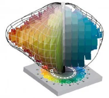
1. Theoretical model of wayfinding (retrieved from Chen & Stanney; 1999:681)....9 2. Understanding spatial navigation………10 3. A view showing the Munsell hue circle (http://dba.med.sc.edu/price/irf/Adobe_tg
/models /images/munsell_sphere.gif)...50 4. Geometrical framework of Munsell Colour System
(http://dba.med.sc.edu/price/irf/Adobe_tg/models/images/3_axes.JPG)...51 5. Geometrical framework showing hue, value and chroma scales arranged in
Munsell Colour System
(http://munsell.com/wpcontent/uploads/2011/09/Munsell-Color-Solid-Plus-base-colortheory300x239.jpg)...52 6. A view showing two sample pages from the Munsell Book of Color (1929)
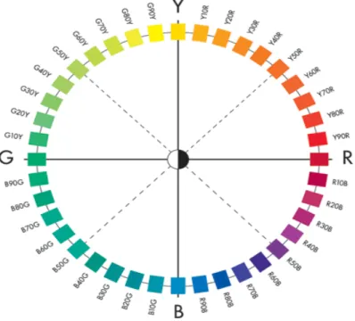
(http://www.handprint.com/HP/WCL/IMG/munsell2.gif)...53 7. A view showing the NCS colour circle
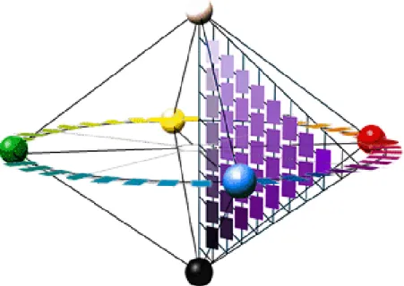
(http://www.ncscolour.com/PageFiles/615/NCS_Colour_Circle.png)...55 8. Geometrical framework of the Swedish NCS colour model
(http://www.handprint.com/HP/WCL/IMG/ncs.gif)...56 9. A view showing a sample page from the NCS color atlas 96
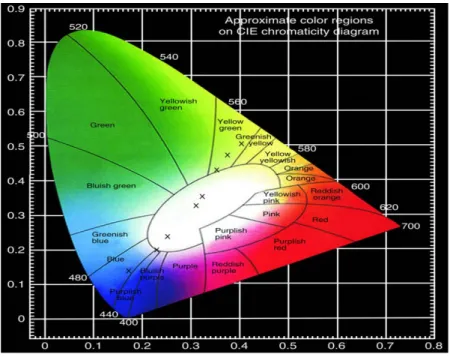
(http://www.handprint.com/HP/WCL/IMG/ncspage.gif)...57 10. The CIE chromaticity diagram
(http://www.nature.com/ncomms/2013/131111/ncomms3717/images/ncomms37 17f4.jpg)...59
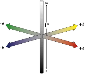
xiii 11. The CIELAB colour space
(http://dba.med.sc.edu/price/irf/Adobe_tg/models/images/CIELAB.gif)...61
12. The CIELAB uniform three-dimensional colour space (http://www.coatsindustrial.com/en/images/Colour%20difference_tcm35-152855.jpg)...61
13. The scope of the study……….…….73
14. Partial plan of the polyclinic showing the route (about 55 meters)………..84
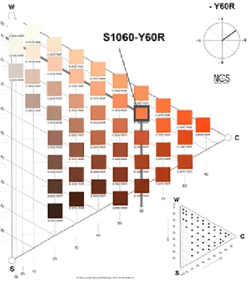
15. Selected colours (Retrieved from NCS catalogue pg: 6)………..……. 85
16. Selected colours (Retrieved from NCS catalogue pg:8)……… 86
17. Selected colours (Retrieved from NCS catalogue pg:16)……… 86
18. Selected colours (Retrieved from NCS catalogue pg:28)………..……….. 87
19. Selected colours (Retrieved from NCS catalogue pg:36)……….……….. 88
20. The neutral colour scheme used for experimental Setting 1 and NCS codes of each selected colour ……….89
21. The warm colour scheme used for experimental Setting 2 and NCS codes of each selected colour ………...……. 89
22. The cool colour scheme used for experimental Setting 3 and NCS codes of each selected colour ………...……. 89
23. Phases of the experiment………..91
24. An elderly participant having the experiment………..93
25. The bar chart showing the mean time spent in route replication task…………..98
26. The bar chart showing the mean time of completion in picture classification task………..106
1
CHAPTER - 1
INTRODUCTION
Wayfinding systems can be supported by the usage of appropriate environmental design elements such as signage, layout and landmarks in order to overcome the difficulties of navigating in unfamiliar environments. The use of colour is an additional tool for navigation. It may be helpful in developing a mental map of the architectural
environment (Dalke, Little, Niemann, Camgöz, Steadman & Hill, 2006). Navigating and orientation in both real and virtual environment can be enhanced by cues. Cues can be summarized as any form of information available within the environment, such as verbal, graphic, architectural and spatial cues (Sun & de Vries, 2009).
Previous research indicated that in various age participant groups (among children, adults or elders), colour improves peoples’ wayfinding and cognitive mapping performances (Dalke et al., 2006; Davis & Therrien, 2012; Farran, Courbois, Van
2
Herwegen, Cruickshank & Blades, 2012; Helvacıoğlu & Olguntürk, 2011; Hidayetoğlu, Yıldırım & Akalın, 2012; Holscher, Meilinger, Vrachliotis, Brosamle & Knauff, 2006; Read, 2003).
Previous research comparing wayfinding and cognitive mapping abilities and performances of elders and younger-aged people, reported that elders have more difficulties than younger-aged people in terms of memorizing maps, navigating, route learning, map learning and place learning because of cognitive decline such as; changes in learning, short term memory, attention and response times (Allain, Nicoleau, Pinon, Etcharry-Bouyx, Barre, Berrut, et al., 2005; Barrash, 1994; Iaria, Palermo, Committeri & Barton, 2009; Jansen, Schmelter & Heil, 2010; Lipman & Caplan, 1992; Mahmood, Adamo, Briceno & Moffat, 2009; Moffat & Resnick, 2002; Rodgers, Sindone & Moffat, 2012; Salthouse & Siedlecki, 2007; Sjölinder, Höök, Nilsson & Andersson, 2005;
Wilkniss, Jones, Korol, Gold & Manning, 1997). Moffat, Kennedy, Rodrigue and Raz, (2006) reported that changes related to age in the areas of the brain which support cognitive mapping might be partially responsible for the deterioration of the wayfinding ability that goes parallel to aging.
Hospitals are public facilities for all ages of people. There might be an increased number of visits to a hospital along with growing age due to the addition of various health risks and potential accidents (DeFrances, Lucas, Buie & Golosinskiy, 2008). Hospitals might resemble a maze of separated, confusing spaces, because of their complex functions and various programs. Hospitals are particularly challenging to navigate because of the
3
complex medical terminology. Due to the visitors’ health concerns as well as stress levels, the navigation process becomes even more challenging (Cooper, 2010). Yoo (1992) pointed out that when people get lost and are unable to orientate themselves, they experience increased blood pressure, headaches, desperate feelings and tiredness.
Moreover, there are other potential wayfinding issues in hospitals as a result of these facilities being extremely large and quite overwhelming with the many departments with medical names. “This issue may further degrade the wayfinding experience of visitors and patients even more than the impact of their current health and/or vision conditions. “All of these factors make healthcare facilities unique and possibly troublesome (especially to older populations)” (Rousek & Hallbeck, 2011:449). Elders need more support than the younger-aged people for navigating by themselves in an unfamiliar environment. For elderly whose cognitive and physical abilities being restricted, navigational aids are essential factors which enhance their wayfinding and eventually living conditions as a whole.
As a result of social, economic, scientific, technological and health-care
developments populations have been living longer and the number of elderly has been increasing. United Nations (2013) stated that in the report ''World Population Ageing'', “The global share of older persons (aged 60 years or over) increased from 9.2 per cent in 1990 to 11.7 per cent in 2013 and will continue to grow as a
proportion of the world population, reaching 21.1 per cent by 2050” (75). Because of the increasing elderly population, designing interiors for elderly becomes an important issue.
4
1.1 Aim of the Study
The primary aim of this study is to explore the effects of colour as a visuospatial cue on spatial navigation and to develop a cognitive map in elderly people, in a simulated virtual polyclinic environment. Previous research showed that the aid of visual cues on spatial perception and wayfinding is essential. However, it is still unclear how the colour scheme of an environment affects the visuospatial navigation performances of elderly people and if it is possible to create easier to navigate indoors for elderly people by using specific colour schemes. The aim of our study is to fill in the gap in the literature regarding the effects of colour on visuospatial navigation of elderly people in a virtually simulated polyclinic environment by comparing three different colour schemes: neutral, warm and cool.
1.2 General Structure of the Thesis
This thesis is comprised of six chapters. After an introductory first chapter, the following three chapters review related literature. In the second chapter, definitions and concepts related to wayfinding and spatial navigation are elaborated on; including the literature review on measuring methods and tasks of spatial navigation performance in virtual environments. Besides, individual differences affecting spatial navigation are explained. Additionally, this chapter also explores virtual reality and spatial cognition research using virtual reality devices. In addition, the third chapter also includes a literature
5
review on measuring methods and tasks of spatial navigation performance in virtual environments.
The third chapter gives the basic definition and concepts of colour and explains the three most widely used colour order systems. Moreover, the third chapter also presents colour as a part of interior design element, its function in wayfinding within previous literature and usage in healthcare environments.
The fourth chapter describes the experiment with its scope, aim, research questions, hypotheses, and methodology. The methodology of the experiment, a detailed selection procedure of the participant group, the used instruments and creation phase of the virtual environment is provided.
In the fifth chapter, the results of the experiment are statistically analysed and the discussion of the results is given with related previous studies in the literature. In the sixth chapter, the major conclusions of the study, limitations, and suggestions for future research are explained.
6
CHAPTER - 2
WAYFINDING AND SPATIAL NAVIGATION
2.1. Understanding Wayfinding and Spatial Navigation
Kevin Lynch (1960) firstly explored the characteristics of an urban space affecting people and how well people remembered physical features. He introduced the term of wayfinding to the literature. After then, different researchers gave many definitions of wayfinding, and contributed to the knowledge on wayfinding over the years.
Wayfinding is the “consistent use and organization of definite sensory cues from the external environment in order to reach a desired destination” (Lynch, 1960:3). Arthur and Passini (1992) maintained that wayfinding is a spatial problem solving activity with three specific yet connected processes: decision making, decision execution, and
7
information processing. According to Arthur and Passini (1992), both perception and cognition are essential parts of information processing. Making and executing decisions are both built on information processing. Wayfinding is also defined as the ability to situate oneself in a location and reach intended destinations or to cognitively and
behaviourally navigate within spatial environments (Passini, 1984; Rovine & Weisman, 1989). Additionally, Lovs (1998) explained the process of with steps in which people first select their goal, and then a destination is selected finally to be completed by selecting a route to follow. According to Golledge (1999), wayfinding is a persuasive, motivated and directed activity; a process in which decisions are made to follow a path or route between the original position and the desired destination.
Arthur and Passini (1992) explained cognitive mapping as a segment of perceiving the environment in which cognition is the origin of information to make and execute a decision. Perception is the mechanism of gathering information by the use of senses, while cognition is the understanding as well as the manipulation of information (Arthur & Passini, 1992). The gathering of information is not sufficient for wayfinding, as the information also has to be understood and manipulated, considering these two steps are essential segments of the wayfinding process. Lynch (1960) maintained that cognitive maps are introduced for tasks of wayfinding. Garling, Book and Lindberg (1984b) suggested that cognitive maps are used when considering “people’s behaviour in social and physical environments is determined by action plans, and, if the execution of such action plans requires travelling, plans for how to travel, termed travel plans are formed and executed”(3). Arthur and Passini (1992) explained cognitive map as “an overall
8
mental image or representation of the spaces and the layout of a setting” (23) and
cognitive mapping is described as “the mental structuring process leading to the creation of a cognitive map” (23). Kitchin (1994) suggested that cognitive maps could be used to solve spatial problems such as wayfinding and navigation.
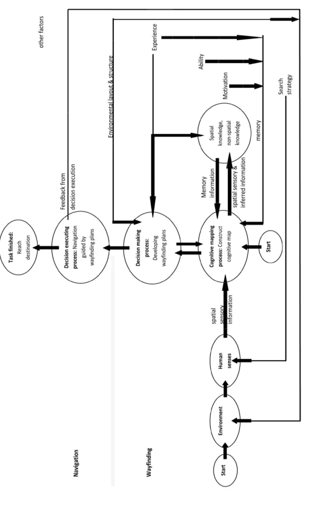
Chen and Stanney (1999) suggested a more elaborated version of Arthur and Passini's (1992) theoretical model of wayfinding process as dividing into three sub-processes: cognitive mapping, decision making (wayfinding plan development), and decision executing (the final and actual physical movement guided by navigation within the environment) (see Figure 1). Earlier suggestions of subdivisions are inferior to the current model, which defines the wayfinding process, including some precise influences of spatial information, orientation and knowledge.
9 F igu re 1: T h eor et ic al m od el of w ayf in d in g ( re tr ie ve d f ro m C h en & S tan n ey; 1999: 681)
10
In the literature, the terms wayfinding and navigation can often be substituted with each other (in some studies, navigation is used as a synonym for wayfinding). Although these terms overlap semantically, there is a significant but subtle difference between them. Montello and Sas (2006) stated that wayfinding is the efficient and goal-directed planning section of navigation. Navigation is the coordinated and goal-oriented form of movement through an environment. It requires first the planning and then the execution of each movement. Montello (2005) explained that navigation might be explained as having two components of locomotion (travel) and wayfinding (see Figure 2). Locomotion is defined as the body’s movement according to the local surrounds;
Navigation Travel / Locomotion (motor component) Wayfinding (cognitive component) (Process of developing spatial knowledge)
Figure 2. Understanding spatial navigation
wayfinding is planning and decision making step that takes the distal and local surrounds into consideration. Finally, travel is the final motion in which the current location is changed after the altering of position to the new position from a view point (Zhang, 2008). It can be referred to as “the perceptual-motor coordination to the local surrounds and includes activities such as moving towards visible targets and avoiding obstacles” (Montello & Freundschuh, 2005:69). The second element of navigation is wayfinding
11
and it is the “cognitive coordination to the distant environment, beyond direct sensorimotor access, and includes activities such as trip planning and route choice” (Montello & Freundschuh, 2005:69) where the navigational path is decided by the knowledge of an environment, the visual cues as well as navigational aids. There are several sensory systems which supply information for navigating and a diversity of cognitive systems is concerned in modifying information from the senses and the memory. (Montello, 2005). Shah and Miyake (2005) suggest that the visual and structural characteristics of physical environments might have a positive or negative effect on the performance of various navigation tasks.
2.2. Cognitive Maps and Three Levels of Spatial Knowledge Acquisition
According to the Chen and Stanney's (1999) wayfinding model, wayfinders usually generally start out by perceiving the environment in a direct way, or from the use of a cognitive map.
“After a cognitive map has been generated, the second main step in the wayfinding process is decision-making. This generally involves using the
cognitive map information generated in the first step to guide the development of wayfinding plans. This is followed by a decision-execution process, in which navigation commences, guided by the wayfinding plans developed in the second step” (Chen & Stanney,1999:676).
12
The wayfinding process can be concluded with the sufficient repetition of these steps until the target destination is reached. To elaborate, cognitive mapping, as defined by Downs and Stea (1973) and Golledge (1987), is the procedure of acquiring, forming, and preserving spatial information and spatial knowledge. A cognitive map is the total sum of environmental information accumulated in the memory. According to the definitions of most researchers, cognitive maps are mental devices that store for simplifying, coding, and ordering the infinitely complex world of human-environment interactions (Arthur & Passini, 1992; Chen & Stanney, 1999; Downs & Stea, 1973; Golledge, 1987; Karimi, 2015; Kitchin, 1994; Montello & Freundschuh, 2005; Montello & Sas, 2006; Passini, 1984). According to Chen and Stanney's (1999) explanation, during the
cognitive mapping process, in which individuals cultivate an understanding of the world that surrounds them, spatial information is gathered by individual sensors and are amalgamated with the accumulated spatial knowledge in order to create a cognitive map which help performing the wayfinding and navigation tasks.
Passini (1984) stated that there are already many existing cues within the environment, and if those cues can be related to the wayfinding task, they are defined as spatial information. In addition to spatial information, sufficient general information on the spatial settings is required to complete wayfinding tasks. Passini (1984) defined three major types of information; sensory, memory and inferred. Sensory information is obtained by an individual’s use of five senses, memory information is the recall from one’s memory and lastly inferred information is gained through inference as in a
13
spatial knowledge is the result of integrated spatial information. Most researchers agreed on dividing spatial knowledge into three separate levels; landmark knowledge, route (procedure) knowledge, and survey knowledge (Darken, 1996; Evans, Fellows, Zorn & Doty, 1980; Garling, Book & Ergenzen, 1982; Jul & Furnas, 1997; Siegel & White, 1975; Thorndyke, 1980).
As stated earlier, a cognitive map is considered the first process of wayfinding. Once a cognitive map is created, the second step of wayfinding process is the decision making step. According to Chen and Stanney's (1999) explanation in the decision making process, “individuals plan actions and structure them into an overall wayfinding plan” (673) which has its roots on the previously created cognitive map. “The result is an action plan that includes information of selected routes and proper actions to move through the routes. The generated action plans are fed back to memory as spatial knowledge” (Chen & Stanney, 1999:676). Garling et al. (1984a, 1984b, 1984c, 1986) stated that action plans are used to link the internal information processing to real
behaviour. Travel plans are a part of the action plan and these travel plans are previously created ways of action utilized to reach the desired destination with the minimum effort required. According to this theory, a hierarchical procedure which incorporates
information from as well as about the environment shapes the travel plans. Therefore, travel plans usually lead to deductions and acquisition of knowledge, which are stored in cognitive maps. These travel plans and the related action plans are often improved and corrected. During this revision process, newer information is gathered which can be used to change and enhance cognitive maps.
14
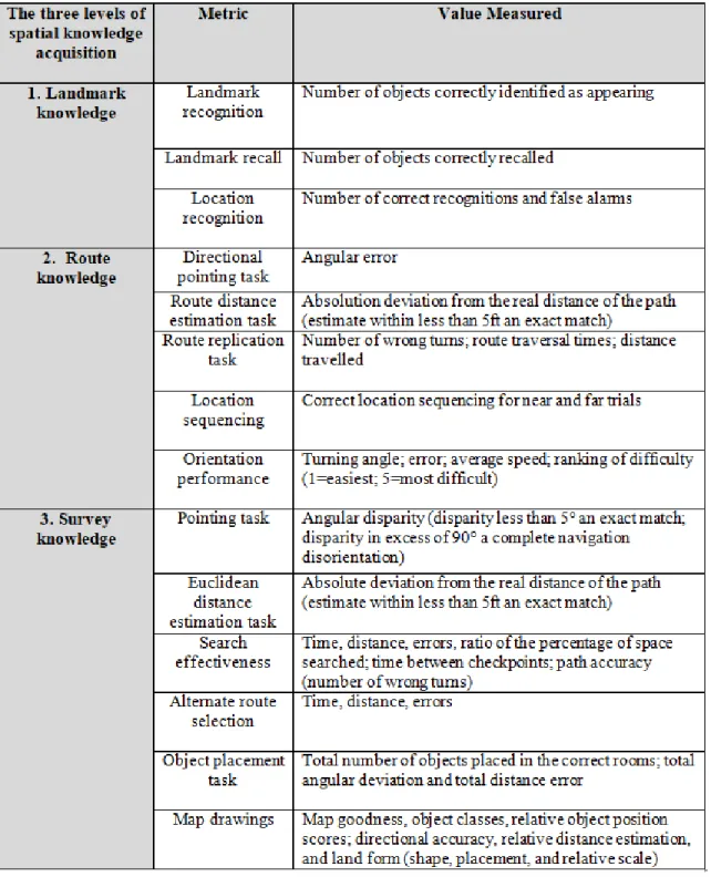
Spatial navigation and knowledge acquisition has difficulties in measurement, because navigating in a virtual environment (VE) is not easy for a human who is accustomed to navigation in the real world. Thus, navigation in virtual environments has a high
probability of the user becoming lost, compared to the real world. (Grant, 1997; Witmer et al., 1996). Peponis et al. (1990) claimed that the landmark knowledge is about the use of salient objects in order to help one's orientation in remembering information. Route knowledge is obtained when landmarks and other relevant visual features are functional in terms of triggering direction based decisions as one navigates from one point to another in a preset path. In this specific type of knowledge, the context of routes are contained which have been travelled previously. Additionally, in the case of many routes and landmarks within a single cognitive map of the environment, survey knowledge is gained thereafter (Edwards et al., 1998). Peponis et al., (1990) attributed survey knowledge to be the ultimate stage of knowledge acquisition. Survey knowledge uses increasingly abstract terms regarding reference and is based on world-centered form of frame of reference. An individual with complete survey knowledge is a person that has obtained navigational awareness. Determining and classifying unique behaviours associated with each and every level of knowledge mentioned paves the way for the surfacing of observable values that are specific to each one. There are major metrics listed in the Table 1 (retrieved from Nash et al., 2000), used for the assessment of the three levels of spatial knowledge acquisition. Under each type of navigational
15
Table 1. Major metrics used for the assessment of three levels of spatial knowledge acquisition (Retrieved from Nash et al., 2000).
16
2.2.1. Landmark Knowledge
Landmark knowledge is the accumulated information of the visual details of certain locations within an environment. This level of knowledge is acquired by directly observing objects within an environment, or simply viewing indirect representations of the environment, such as photographs or videos. Landmark knowledge is the essential component that builds towards survey and route knowledge (Darken, 1996; Goldin & Thorndyke, 1981).
Landmark knowledge takes a specific landmark in an environment into consideration when measuring navigational learning and knowledge assessment. Recognition of these specific landmarks makes the navigation process easier in VEs, as these landmarks create a sense of immersion in the VE. The landmarks in studies conducted in VEs consist of three dimensional objects to simple differentiating landscapes, or wall markings, as these objects all have distinct differences from the landscape, creating a certain sense of recognition in the participants of navigational exercises.
Landmark knowledge was measured by McCreary and Williges (1998) on the
experiment where the participants navigated through a six room VE. In this VE, random sequences of pictures of objects were shown to the participants and the number of correct identification of objects in the participant responses correlated to the landmark knowledge of the individual participants.
17
In addition to such a study, these landmark objects are also asked to be written down by the participants in order to determine which ones are remembered and recognized without any time constraints in the experiment (Edwards et al., 1998, Gunther, 1997). This method was called the landmark recall which is based on the number of objects correctly recalled.
The last metric in the landmark knowledge area is the location recognition, which is in the study by Goldin and Thorndyke (1982); Witmer et al., (1995), where the number of correct recognitions and false alarms of the participants were noted and measured to determine the navigational performance. Alawadhi et al. (2011) also mentions the studies of Craik (1968) and Cohen (1980). Craik (1968) measured the spatial knowledge of a subject via place recognition tests and questionnaires regarding landmark and
location. Cohen (1980)'s subjects were exposed to a tour of a museum, and afterwards he measured the ability of the participants of recalling sequential progression and
recognition of elements. This was another cued recall task, just like the study by Witmer et al. (1995).
2.2.2. Route Knowledge
Route knowledge is defined as the information that relates to the sequence of actions needed to follow a route in a precise manner. It is also known as procedure knowledge. This name is a result of a represented procedure, which describes the movement starting
18
from a point, having certain checkpoints in anchor points, landmarks and several points of stopping in the route, and having the goal or final destination in the end (Gale, Golledge, Pellegrino & Doherty, 1990). In VEs, route knowledge is used as the
assessment method, measuring the navigating person’s ability to point certain landmarks in a given route. There are several metrics on the route knowledge assessment category within the aforementioned directional pointing task. In this task, the navigator points towards certain locations while navigating between a start point and a destination, stopping at landmarks to assess whether they were explored earlier or not (Boyd et al., 1997; Goerger et al., 1997). If the navigator is successful in memorizing the landmarks within a given route correctly, this translates into properly gained route knowledge. In the opposite case where the navigator does not adequately memorize the route, this leads to difficulties in wayfinding.
In addition to the directional pointing task, Goldin and Thorndyke (1982); Satalich (1995) developed the route distance estimation task. The participants were asked to navigate between two points in a pre-determined route, to evaluate and estimate the distance of the path travelled, comparing it to the real distance. The values measured in this study are the absolution deviation according to the real distance of the route which is considered within equal or less than 1.5 meters of an exact match.
Another study was conducted by Witmer et al. (1996) under the name of the route replication task. In this task, the participants were involved in a VE route several times, in which they used a form of study aid such as coloured photographs, maps or step by
19
step instructions to measure the accuracy of navigating through the route in the real world. In this study, the values measured were the number of wrong turns, route traversal times and finally the total distance travelled. These were compared to the navigation of the real world route, to assess the navigational performance of the participants in the route within the VE.
Bakker et al., (1998), created the study of orientation performance, which is also under the category of route knowledge metrics. This study considered and assessed the route knowledge by measuring the participants' orientation, in terms of their ability to orient themselves in the measurement of degrees, in relation to the features and landmarks in the given environment. In this study, the turning angle of participants, errors, average speed of participants, ranking of difficulty from 1 being the easiest and 5 being the most difficult were the values measured.
Goldin and Thorndyke (1982) also studied the route knowledge metrics, in the study of a location sequencing task, where researchers observe the sequence of actions which are performed at certain locations in the route by the participants, to measure the sequencing of location in terms of trials that are either near or far away. Slides were shown to the participants depicting objects in pairs, where they were asked to determine which occurred first, and which occurred later in the virtual experimental route. Edwards et al. (1998) along with Gunther (1997) assessed route knowledge in timing metric where the participant's locating ability for an object in the VE was measured compared with the timing of a previous identification in a guiding tour session.
20
There is much research in the literature, studied the route knowledge metrics such as Cohen and Schuepfer (1980), Farran et al. (2012), Jansen-Osmann and Wiedenbauer (2004), Tang et al. (2009), Tlauka et al. (2005). Tang et al. (2009) conducted a VE experiment in which three scenarios were created, in a game that took place in an emergency escape situation to determine whether various emergency signs aid
wayfinding in these particular situations, and if so, to what extent. The time spent and the number of errors was the measurements for this study. It was concluded that the lack of signs leads to a considerably slower escape than either older signs or new signs. Additionally, males had a better wayfinding performance compared to females.
Jansen-Osmann and Wiedenbauer (2004) studied the role of landmarks on navigation by comparing children and adults in a VE experiment. The number of errors and decision points (walking distance) were measurements for the evaluation of this study. No difference has been found between older children and adults in terms of the number of errors and decision points. Moreover, female participants conducted more errors when exploring the maze without the landmarks present, therefore showing that females rely on the existence of landmarks significantly more than males.
Tlauka et al. (2005) investigated the effects of sex differences in spatial knowledge which has been gathered through a virtual shopping center’s simulated exploration experiment. The wayfinding task took note of the time spent and the number of errors to evaluate the results, which prevailed that females took a longer time to travel from the starting location to the final destination while following a route in the VE that is the
21
shopping center. In addition, females made more frequent erroneous turns and directions.
Farran et al. (2012) investigated the influences of focal (easy to verbalise) and non-focal (difficult to verbalise) colours as an environmental cue when learning and memorizing a route in a VE. The number of errors was one of the measurements for the evaluation of route task. It is found that adults with Williams’s syndrome made significantly more errors than the typically developing 9-year-olds, but not the 6-year-olds. It was also found that among all three participant groups, fewer errors were reported and more colours were memorized in the focal coloured setting compared to the non-focal coloured setting.
Cohen and Schuepfer (1980) explored how landmarks and routes were perceived by children and adults in a VE. The number of errors and the number of decisions were measurements for the evaluation of route task. The findings showed that six graders made significantly less incorrect turn choices compared to second graders. Additionally, sixth graders made more errors than adults, creating an age-based correlation. To
elaborate, children relied more on the position as well as the sequence of landmarks compared to adults, who made less mistakes due to landmarks.
22
2.2.3. Survey Knowledge
Survey knowledge shows the configuration relations between routes and locations in an environment. It converts the topographic characteristics of the space, such as the object locations relative to an anchored extensive coordinate system, the inter-object Euclidean distances and the shape of large spatial objects which are unidentifiable from any
viewpoint alone (Thorndyke & Hayes-Roth, 1982). The other names for survey knowledge are configurational knowledge and secondary spatial (Chen & Stanney, 1999). Thorndyke and Hayes-Roth (1982:586) suggested that “Acquiring survey knowledge solely through navigation entails both costs and benefits. Our data indicate that the principal advantage of such learning is the ultimate superiority of the acquired cognitive map”.
Survey knowledge is conducted in the form of a cognitive map; therefore the metrics under this category assess the participants' internal ideas following exposure to a VE in the corresponding studies. The first of survey knowledge metrics is the pointing task conducted by Satalich (1995). Koh (1997) and Satalich (1995) used the exposure to VE to record the accuracy of performance of the participants as they pointed to the locations of objects placed in the VE. In these measurements, the angular disparity was the main value measured which was the disparity less than 5 degrees considered an exact match and the difference above 90 degrees to be considered a complete navigation
disorientation. Another study was conducted by Koh (1997), Satalich (1995) under the metric of Euclidean distance estimation task. The “birds-eye” distance travelled was
23
estimated by individual participants considering the objects in the environment as well as notable locations. An estimate within less than 1.5 meters was considered an exact match in both these studies.
Darken and Sibert (1996a)'s study on survey knowledge was called the search
effectiveness metric and it recorded the distance travelled and the ratio of space searched compared to the total virtual environment space spanned while the individual
participants practiced primed searches without any prior information given to them. The studies of Satalich (1995), Goerger et al. (1997) and Boyd et al. (1997) also used the search effectiveness metric. Satalich (1995), for example, asked the participants to locate a distinct room in the VE of the study. In this case, the most efficient routes to the room were blocked by a fire in the building. In this study, the participants were asked to estimate the Euclidean distance between the objects and their current location. The results showed that males had a significantly better spatial ability in estimating the distance compared to females.
Maps were another important metric subject to measure survey knowledge. For example, Edwards et al. (1998) and Gunther (1997) asked the participants to recall and place the important objects recalled on a paper map after the VE exposure session. In the study by Gunther (1997), 3D sound was implemented into the virtual environment to help the participants find certain exact locations within the environment or enhance the rate at which spatial knowledge is gained by the participants. The results of the study showed that the implementation of the 3D sound did not help the participants gain spatial
24
knowledge in an increased rate, while having a positive effect on the time spent in locating objects within the environment. Another metric regarding mapping methods were used by Boyd et al. (1997) and Goerger et al. (1997), where participants were asked to place magnets on a white board, in distance regarding relations to each other, as if the board was a top-down view of the VE, in the format of a map. The arrangement of magnets was later used to measure relative object position scores and directional
accuracies of the participants. Goldin and Thorndyke (1982) conducted an experiment to measure survey knowledge comparing simulated and actual navigation. The results showed that the participants in the simulated navigation showed better or equal survey knowledge compared to the participants in the actual navigation. Billinghurst and Weghorst (1995), Darken and Sibert (1996b) also measured the spatial knowledge by requesting the participants to draw a map of the VE after the exposure to that particular environment.
2.3. Individual Differences Affecting Spatial Navigation
There are certain individual differences that affect spatial navigation in a crucial way. Several sides of individual differences were identified previously in the literature, such as; spatial familiarity, motivation, sense of direction, learning style, handedness of users, occupation, education level, memory, and experience, however with respect to this study age and sex differences of individuals are considered major factors which affect an individual's spatial navigation performance.
25
2.3.1. Age Differences
Age has a significant effect on user's ability in wayfinding. There have been numerous studies over the years focusing on the difference in wayfinding behaviour and mental processes that take place during this activity caused by age differences (Cornell, Heth, & Skoczylas, 1999; Lawton, 1994; Passini et al., 1995; 1998; 2000; Weisman, 1987). Elders are more likely to suffer memory loss and become disoriented, which restrains their wayfinding ability. Studies indicated that “wayfinding behaviour and accuracy are affected by the outcomes of aging such as lack of concentration and memory disorders as in dementia of Alzheimer type” (Passini et al., 1998:2000). Previous research comparing elders and younger-aged group wayfinding and cognitive mapping abilities and performances, reported that elders have more difficulties than the younger-aged group in terms of memorizing maps, navigating, route learning, map learning, and place learning because of cognitive decline such as; changes in learning, short-term memory, attention and response times (Allain et al., 2005; Barrash, 1994; Iaria et al., 2009; Jansen et al., 2010; Lipman & Caplan, 1992; Mahmood et al., 2009; Moffat & Resnick, 2002; Rodgers et al., 2012; Salthouse & Siedlecki, 2007; Sjölinder et al., 2005; Wilkniss et al., 1997).
Moffat, Zonderman and Resnick (2001) explored age differences of spatial memory in a virtual environment (VE) navigation task, comparing 133 young, middle and old aged participants. The completion time, the number of errors and distance number of errors were the measurements for this study. It is found that elder volunteers took a longer time
26
to solve the trials, travelled longer distances and made significantly more spatial memory errors compared to younger participants of the study.
Lee and Kline (2011) examined the influence of architectural wayfinding aids on wayfinding performance by comparing an elderly group (38 elders between the ages of 66 to 82) and a younger-aged group (63 young adults between the ages of 18 to 24) in a virtual ambulatory healthcare facility. In this study, participants directed the researcher verbally; in each decision point, participants answer open-ended questions about architectural aids and their errors are measured. It is found that the younger-aged group had a better wayfinding performance compared to the elderly group. The elderly group of participants often relied on their limited ability of recalling from memory when insufficient wayfinding aids were present, thus leading to them experiencing further difficulties in wayfinding.
Barrash (1994) explored the impact of aging on route learning ability comparing five different age groups (80 individuals -divided regarding age intervals- between the ages of 18 and 78). It is found that the elderly participants had more difficulty in learning the route in terms of making errors.
Iaria et al. (2009) explored the effects of aging on developing and using cognitive maps in a VE, comparing 30 young (19-30 years) and 25 older (50-69 years) participants. It is seen that elderly participants needed more time to create and develop a cognitive map of the environment compared to the younger participants while needing more time as well
27
as making more frequent errors when using the cognitive map for purposes of orientation.
Jansen et al. (2010) examined the process of the acquisition of spatial knowledge in 20 younger adults (20–30 years), 20 middle-aged adults (40–50 years), and 20 elderly (60– 70 years) in a desktop based VE, in which the participants were taught a way within a virtual maze environment with landmarks and were asked to recall the landmarks while drawing an overview of the maze. “The results revealed a general decline in spatial memory of the elderly, that is, in the time needed to learn a new route, in the retrieval of landmarks from memory (landmark knowledge), and in the ability to draw a map
(configurational knowledge)”(Jansen et al., 2010:54).
Moffat and Resnick (2002) investigated how navigational behaviour was affected by age differences in a virtual Morris water maze. The research also explored the ability of the elderly to cultivate cognitive maps after concluding the navigation experience. It was found that compared to the younger participants, elderly volunteers covered longer linear distances to locate the hidden platform.
Sjölinder et al. (2005) examined the acquisition of spatial knowledge in a virtual grocery shop environment, comparing 24 young-aged adults (20-31 years) and 24 elders (61-77
years). The findings revealed that the elderly participants required more time to solve the
tasks; and while performed similar navigation performance in the physical world, the
28
Wilkniss et al. (1997) explored the spatial learning abilities in 25 younger adults (18-21 years) and 25 healthy older adults (59-81 years) evaluating two different tasks; recalling the route and drawing a 2-dimensional map. It is found that the elderly participants had significant difficulty retracing the route, ordering landmarks and memorizing the route.
Moffat et al. (2006) examined how age differences effect functional brain activation during VE navigation task comparing 30 young (21-39 years) and 21 older (60-78 years) participants. It is reported that the changes in the brain areas that support cognitive mapping affected by aging are responsible to a degree for the deterioration in wayfinding ability.
2.3.2 Sex Differences
The sex difference is still a debated issue in the literature, not only in wayfinding but also in spatial ability in general (Voyer, Voyer, & Bryden, 1995). Although sex differences are not uniformly found to be significant, when they are found they often favour males (Allen & Hogeland, 1978; Linn & Petersen, 1985; McGee, 1979).
Lawton (1996) maintained that the origin of sex differences lie in different strategies that are used to overcome orientation issues. It is also shown that males use an
orientation strategy whereas females use a routing strategy. To elaborate, it was found that females show that they rely on landmark-based route information more than males
29
while males simply adjust to global reference points such as the directions of north, west, south or east, or even sun’s current position (Lawton, 1994; 1996). Architectural differentiations and anomalies are the environmental cues used by females in their routing strategies. Environmental cues are critical constituents of wayfinding that increase the awareness of individuals regarding their environment while facilitating a wayfinding task.
Jansen-Osmann and Wiedenbauer (2004) conducted research on how the use of landmarks affects wayfinding. In the experiment, participants were taught a route by using a slide presentation. After the presentation, participants were asked to remember and point out the inherent landmarks in order to find their way in a VE. The findings prevailed that male participants relied on landmarks less than female participants. Sandstrom, Kaufman and Huettel (1998) explored the incorporation of disparate distal cues comparing males and females in a VE Morris Water Maze task. The results showed that males use both landmark and geometric information while females solely rely on the former. Additionally, males and females use different strategies while focusing on different attributes of the environment. Finally, it was presented that in the cases where landmark and geometric information was available at ready, males were faster at reaching a hidden target compared to females.
Tlauka et al. (2005) studied the acquisition of spatial knowledge within a virtual shopping centre comparing males and females. A series of tasks comprised of wayfinding, directional estimates and distance estimates as well as a map placement
30
tasks was given to the participants. It was found that there was significant difference favouring male participants. Sex difference was prevalent in even measures such as pointing accuracy and the number of errors in the navigation task (Bryant, 1982; Devlin & Bernstein, 1995; Lawton, Charleston, & Zieles, 1996). Devlin and Bernstein (1995) found that the errors of males were significantly less in number compared to females in a computer simulated wayfinding exercise. Galea and Kimura (1993) and Devlin and Bernstein (1995) concluded their studies with consistent results on sex differences. The average time of completion was longer for females in wayfinding tasks. The results were also less accurate in the wayfinding performance of females when compared to male participants. The pointing task measured the amount of control over the information necessary to successfully navigate within an environment. Lawton (1994) also showed that females reported more errors in pointing tasks with lower confidence than males. The significant advantage of male participants was recorded in spatial route learning in an unfamiliar environment as well as certain tasks that need survey knowledge such as drawing maps and estimating distances travelled (Castelli, Corazzini, Geminiani 2008; Coluccia, 2007; Çubukçu & Nasar, 2005; Devlin & Bernstein, 1995; Lawton & Morrin, 1999; Moffat et al., 1998; O'Laughlin & Brubaker, 1998; Tlauka, Brolese, Pomeroy, Hobbs, 2005).
Results were inconclusive in the broad spectrum regarding sex differences and the sense of direction. Bryant (1982) found that males had a higher rating of their own sense of direction compared to females in a self-reported study. On the other hand both Kozlowski and Bryant (1977) and Vanderberg, Kuse and Vogler (1985) found no
31
significant sex related difference in the sense of direction. Pedersen (1999) conducted a self-rating environmental competency test. The results showed that males were more successful and competent according to their reported results compared to females. The same bias was seen in the wayfinding abilities of both sexes, leaning towards a more confident reporting from men. This shows that there is a difference in terms of confidence levels between male and females. The higher level of anxiety reported by females on performing spatial tasks combined with less confidence values reported while drawing the map of a floor plan as well as the feeling of uncertainty reported while navigating in a building also support these findings (Lawton & Kallai, 2002; Lawton et al., 1996; O'Laughlin & Brubaker, 1998). A high portion of the studies revealed that sex differences were present in wayfinding strategies as well as accuracy. These findings presented that males had a better performance in most of the cases. (Lawton, 1996; McGuiness & Sparks, 1983; Miller & Santoni, 1986; Ward, Newcombe, & Overton, 1986).
2.3.3 Other Individual Differences
Apart from the individual differences affecting spatial navigation such as age and sex; handedness, familiarity, experience, visuospatial abilities, education level and
occupation are also the other factors. People navigate and behave differently in environments while the information they use is different for a range of reasons. There
32
are many individual factors and wayfinding styles affect how people structure the environment cognitively.
One of the factors that influence wayfinding performance is the handedness of users. Some users have a right hemisphere dominance which is seen in left-handers, and this attribute is reported to be connected to making significantly fewer errors compared to right-handers or left-hemisphere dominant individuals in the computer kiosk wayfinding task in Delvin and Berstein’s study (1997). Right hemisphere dominance was been associated with higher levels of creativity as well as more developed mental rotation skills (Burke et al., 1989; Coren, 1993; Newland, 1981; Porac & Coren, 1981; Stewart & Clayson, 1980). Spatial familiarity is depicted as merely 'how well a place is known' (Chalmers & Knight, 1985). Most of the studies have agreed on that familiarity has a positive impact on the experience of spatial orientation and wayfinding behaviour. Golledge (1991) explained that as familiarity within an environment is increased, a cognitive map can be developed. Ruddle, Payne and Jones (1998) found that the increased familiarity provided more accurate spatial knowledge in a simulated environment.
Doğu and Erkip (2000) examined spatial factors affecting wayfinding behaviour of individuals in a shopping mall. They found that familiarity is the most critical factor that affects wayfinding behaviour in interior spaces. O'Neill (1992) reported that the increase of familiarity within a space increases the wayfinding performance as well as spatial orientation and wayfinding tasks in terms of both lower reported latency values
33
and higher values of accuracy. Also, the degree of complexity of the layout of the environment becomes less significant. According to O'Neill's (1992) study, familiarity is a more essential factor which directly influences the wayfinding performance of
individuals compared to the spatial factors.
Background of the individuals also affects wayfinding. People are socialised differently, as their upbringing is influenced by different geographical and social environments. Their way of perceiving and using the environment differ in regards to their different cultural backgrounds. Doğu and Erkip (2000) stated that wayfinding behaviour is different in individuals because of factors such as education, profession and past experiences/backgrounds with different settings. It is even affected by different modes of travel. For example, a taxi driver is a professional who is constantly engaged with travelling distances. Due to his route changing on a daily basis, he has a higher level of knowledge regarding streets and roads as well as neighbourhood locations compared to people with different professional pursuits (i.e. housewife, teacher, etc.).
Experience, visuospatial abilities, education level and occupation of the individual are also some interacting factors affecting wayfinding and navigation performance. Saku (1992) presented that in contour map reading and route planning tasks, geography students performed significantly better than psychology students. Students comprised of each department were divided into two groups, and these groups were separated by the variable of one group receiving 20 minutes of training in geographical lexemes. This
34
trained group had a better performance compared to the groups that were not trained. Tkacz (1998) presented that map-reading can be taught alongside with navigational techniques to improve navigation skills.
Bogue and Marra (2003) stated that visuospatial skills are the abilities to first recognize and then organize information when a person sees something and then interprets it. Visuospatial skills can be exemplified by the activities of reading, shape recognition, finding objects within an image or following a map. Besides, Voyer et al. (1995)
explained that visuospatial ability might not be a unitary construct, and instead could be an amalgamation of certain skills. Visual-spatial skills are therefore essential for success in many engineering courses and all technical professions (His, Linn, & Bell, 1997; Miller & Bertoline, 1991; Sorby & Baartmans, 2000). Peters, Chisholm and Laeng (1995) have come up in a sample where students of engineering had a better
performance on the Mental Rotations Test compared to students who pursued Bachelor of Arts degrees. Additionally, male engineering students had a better performance compared to female engineering students, thus showing a sex difference.
Visuospatial ability is defined as the ability to process information that involves spatial relations (Yang, Conners, & Merrill, 2014). Linn and Petersen (1986), explained the four common types of spatial abilities that are; visuospatial perception, spatial visualization, mental folding and mental rotation. Visuospatial perception is the ability to perceive spatial relationships in regards to the orientation of one's body without taking the distracting information into consideration (Linn & Petersen, 1986). On the other hand,
35
the mental ability to manipulate and rotate objects in space quickly as well as accurately is called the mental rotation. Spatial visualization is explained as a complicated and multiple step manipulation of spatially recognized information. These abilities are interceded and supported by an additional fourth spatial cognitive element which is the spatial working memory (Shelton, Elliott, Hill, Calamia & Gouvier, 2009).
Visuospatial working memory (Baddeley, 1986) is the aptitude to collect visual-spatial memories under attentional control temporarily, to be able to accomplish a given task. Baddeley (2000) suggests that this particular cognitive aptitude may have certain
individual differences for higher level spatial abilities, exemplified with mental rotation. This Spatial working memory also stands for storing large data in terms of short-term spatial memories “This memory is used in the temporary storage as well as manipulation of visual-spatial information including memorizing shapes, colours, location and motion of objects in space. It is also present in tasks that include the planning of spatial
movements such as planning a route within and through a complex building” (Baddeley, 2000:423).
2.4. Virtual Reality and Its Use in Spatial Navigation Research
Virtual Environments (VEs), the platforms that allow the simulation of 3D environments on a computer, are an increasingly used method for wayfinding and spatial navigation studies (Blackman, Mitchell, Burton, Jenks, Parsons, Raman, et al., 2003; Cohen &
36
Schuepfer, 1980; Cubukcu & Nasar, 2005a, 2005b; Devlin & Bernstein, 1995; Farran et al., 2012; Jansen-Osmann & Wiedenbauer, 2004; Moffat et al., 1998, 2001, Morganti, Carassa & Geminiani, 2007; Omer & Goldblatt, 2007; Ruddle et al., 1998; Ruddle & Peruch, 2004; Sandstorm et al., 1998; Tang, Wu & Lin, 2009; Tlauka et al., 2005; Umemura, Watanabe & Matsuoka, 2005). VEs are now able to closely approximate real world conditions due to the advancements in computer graphics (Hardiess, Mallot, Meilinger, 2015).
In the real world, there are many variables and it is impossible to control all of them in an experiment setting. In order to examine a specific condition’s relationship with a factor, one must control all the variables within a setting. In these cases, a simulated environment provides a more isolated experiment setting in which the variables can be controlled. Hardiess et al. (2015) stated that the term virtual reality (VR) was initially introduced by Jaron Lanier in 1989. His definition states that, VR is an amalgam of technologies created to generate a human-computer interface which makes it possible for users to interact with, immerse in, and feel the presence within a computerized 3D environment, while also using their natural senses and motor skills in conjunction. According to the encyclopaedic definition, VR is “the use of computer modelling and simulation that enables a person to interact with an artificial three-dimensional visual or other sensory environment” (Lowood, 2018:1). Vilar and Rebelo (2010) explained that VR uses a computerized technology in which an illusion of reality is created where the user can interact with the environment. The main objective is to create a realistic environment for the user.
37
Rebelo, Duarte, Noriega and Soares (2011) explained that the concepts of immersion, presence, interaction, and involvement are crucial to understand both the physical and psychological experience of VR users. Rebelo et al. (2011) introduced presence as “a subjective concept associated with psychological aspects of the user relationship to the sense of being in the VE” (383). They also indicated that presence refers to experiencing the VE without being aware of one's own actual physical existence. Presence is defined as the sense of embodiment felt in the virtual environment, without noticing the physical space where the user’s body resides in. VR is also suggested to researchers due to its benefits in fields such as spatial cognition, wayfinding and cognitive mapping (Richardson, Montello & Hegarty, 1999; Sharlin, Watson, Sutphen, Liu, Lederer & Frazer, 2009; Wu, Zhang & Zhang, 2009). Involvement and immersion are presented as required conditions for experiencing presence. According to Witmer & Singer (1998), involvement is “the psychological state experienced as result of focusing one's energy and attention on a coherent set of stimuli or meaningfully related activities and events” (227). Witmer and Singer (1998) also defined immersion as “the psychological state characterized by perceiving oneself to be enveloped by, included in, and interacting with an environment that provides a continuous stream of stimuli” (227). Rebelo et al. (2011) explained that video games, for example, include a high level of involvement when played on a non-immersive standard home television. Thus, involvement is directly related to the level of concentration on the VE, which means that any factor that distracts the user can affect the involvement. Moreover, as Rebelo et al. (2011) clarified that “the immersion provided by a virtual environment is directly related to the isolation from the real world and the quality of interaction involved within tasks and the environment in