ABSOLUTE AND RELATIVE DATING OF HALLAN ÇEMİ TEPESİ
A Master’s Thesis
by
ERICA HUGHES
Department of
Archaeology and History of Art Bilkent University
Ankara June 2007
ABSOLUTE AND RELATIVE DATING OF HALLAN ÇEMİ TEPESİ
The Institute of Economics and Social Sciences of
Bilkent University
by
ERICA HUGHES
In Partial Fulfillment of the Requirements for the Degree of MASTER OF ARTS
in
THE DEPARTMENT OF
ARCHAEOLOGY AND HISTORY OF ART BİLKENT UNIVERSITY
ANKARA June 2007
I certify that I have read this thesis and have found that it is fully adequate, in scope and in quality, as a thesis for the degree of Master of Arts in Archaeology and History of Art.
--- Dr. Marie-Henriette Gates Supervisor
I certify that I have read this thesis and have found that it is fully adequate, in scope and in quality, as a thesis for the degree of Master of Arts in Archaeology and History of Art.
--- Dr. Thomas Zimmerman Examining Committee Member
I certify that I have read this thesis and have found that it is fully adequate, in scope and in quality, as a thesis for the degree of Master of Arts in Archaeology and History of Art.
--- Dr. Tristan Carter
Examining Committee Member
Approval of the Institute of Economics and Social Sciences
--- Prof. Erdal Erel Director
ABSTRACT
ABSOLUTE AND RELATIVE DATING OF HALLAN ÇEMİ TEPESİ Hughes, Erica
M.A., Department of Archaeology and History of Art Supervisor: Dr. Marie-Henriette Gates
June 2007
This thesis challenges the claim that Hallan Çemi (near Batman in Southeastern Turkey) was occupied during the Epipaleolithic (11th millennium BP). While techno-typological analyses of some objects, chipped stone in particular, appear to place the site’s occupation within the 11th millennium, the iconography etched into ground stone and worked bone is too similar to PPNB sites in the Urfa Plain to ignore. The excavator himself has provided various descriptions of the site, from Epipaleolithic to Aceramic Neolithic. This terminological discrepancy reflects not only on the problem of dating Hallan Çemi, but also on the larger issue of how one should describe the prehistory of Southeastern Anatolia. The latter problems are claimed to be the combined product of a) the relatively few sites within the region with which to contextualize Hallan Çemi and construct a local chrono-cultural scheme, and b) the related issue of imposing terminologies from other regions which may not be appropriate for Southeastern Anatolia.
ÖZET
HALLAN ÇEMİ TEPESİ’NİN MUTLAK TARİHLEMESİ VE GÖRELİ TARİHLEMESİ
Hughes, Erica
Yüksek Lisans, Arkeoloji ve Sanat Tarihsi Bölümü Tez Yöneticisi: Dr. Marie-Henriette Gates
Haziran 2007
Bu tez, Hallan Çemi sitesinin, Epi-paleolitık dönem boyunca insanlar tarafından kullanıldığı şeklindeki görüşü sorguluyor. Bir taraftan, yontma taş başta olmak üzere, nesnelerin tekno-tipolojik analizi, sitteki insan yerleşimini günümüzden 11 bin yıl önceye tarihliyor gibi gözükürken, diğer taraftan, sürtme taşa ve işlenmiş kemik nesnelere kazınmış ikonografi, Urfa Ovasındaki Çanak-Çömleksiz Neolitik B sitlerinde ikonografilere gözden kaçmayacak kadar yakındır. Kazıyı yapan, sit için Epi-paleolitikten Akeramik Neolitiğe uzanan çeşitli betimlerede bulunmuştur. Bu terminoloji farkı, Halan Çemi’nin tarihlenmesi probleminin yanı sıra, bütün bölgenin tarihöncesinin nasıl betimlenmesi gerektiği biçimindeki daha geniş çaplı bir sorunu yansıtıyor. Bu ikinci sorun şu iki faktörün ürünüdür: a) Halan Çemi’yi bağlamına oturmak ve yerel bir krono-kültürel şema yaratabilmek için bölgede gerekenden az sayıda sitin olması,
b) başka bölgelerden edinilmiş terminolojinin, uygun kuşkulu olduğu halde, bu bölgeye empoze edilmesi.
TABLE OF CONTENTS ABSTRACT ... iii ÖZET ... iv TABLE OF CONTENTS ... v LIST OF FIGURES ……….. vi CHAPTER 1: INTRODUCTION ... 1
CHAPTER 2: CHIPPED STONE .………. 12
CHAPTER 3: GROUND STONE ………. 25
CHAPTER 4: ARCHITECTURE ..……… 38
CHAPTER 5: SEDENTISM AND DOMESTICATION ……… 53
CHAPTER 6: RADIOCARBON DATING ……… 72
LIST OF FIGURES
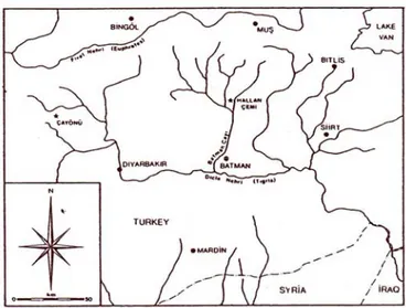
Fig. 1 Map of the Upper Tigris drainage showing Hallan Çemi. ………… 4 After Rosenberg, 1999.
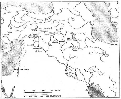
Fig. 2 Selected Epipaleolithic and Neolithic sites………. . 7 Adapted from Hole, 1994.
Fig. 3 Possible ways microliths could have been mounted as projectiles. ….. 19 After Clark 1975-7, Akkermans and Schwartz 2003.
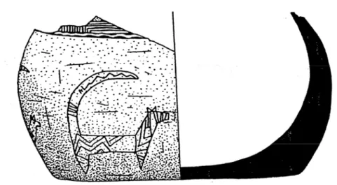
Fig. 4 Vessel fragment from Hallan Çemi with incised canid. ………27 After Rosenberg and Davis, 1992.
Fig. 5 Zoomorphic pestles from Hallan Çemi. ………31 After Rosenberg and Davis, 1992, and Rosenberg 1994b.
Fig. 6 Shaped pestles from Nemrik 9. ………..31 After Kozlowski and Kempisty 1990.
Fig. 7 Notched batons from Hallan Çemi ……… 33 After Rosenberg 1994a.
Fig. 8 Notched pestles and phallus from Nemrik 9. ………34 After Kozlowski and Kempisty 1990.
Fig. 9 Excavated building levels at Hallan Çemi. ………40 After Rosenberg 1999.
CHAPTER 1
INTRODUCTION
The difficulties that scholars face when dating pre-Bronze Age sites are especially exacerbated in Southeast Anatolia. There is no consensus among scholars as regards a single set of labels for the area and often comparative terminologies from discreet regions are used in the stead of terminologies or chronologies derived from a quorum of local sites. This dissonance adds to the already difficult task of determining when an object was created, how long it was used, or when a seed was buried. Both relative and absolute dating methods are suspect the farther back in time one reaches, and creating a chronology of events becomes even more problematic.
Hallan Çemi [Fig. 1, 2], a site near Batman in eastern Turkey, has variously been described as: Epipaleolithic (Rosenberg et. al. 1998: 27); Protoneolithic (Peasnall 2002 : 5); Pre-Pottery Neolithic A (PPNA) (Özdoğan and Balkan-Atlı 1994: 206); and Aceramic Neolithic (Rosenberg 1999: 26).
In order to investigate the dating of Hallan Çemi, I will compare and contrast its idiosyncrasies with those of sites dated to the 11th millennium BP and the 9th millennium BP, the Epipaleolithic and PPNA, respectively.
Site Background
Hallan Çemi Tepesi was identified as an archaeological site by Rosenberg and Togul during the four weeks of the Batman River Survey, conducted in 1990 to identify sites in danger due to a dam project on that river (Rosenberg and Togul 1991: 244). Among the surface samples collected were fragments of incised stone bowls, grinders, pierced stones, as well as triangular microliths, borers and scrapers, more than half of which were obsidian (244). These indicated that the complex Neolithic cultures in Anatolia may have had a local precursor, and thus the site was chosen for excavation (Rosenberg 1991: 117). The small mound, which rises to 4.3 meters on the west bank of the Sason Çayı, covers about 0.7 hectares; of which 425 sq. meters (including baulks) was exposed in 1991 (Rosenberg 1992: 118). Salvage work continued for the next three seasons, with a total of 19 weeks of excavation which ultimately exposed 612 square meters (Peasnall 2000: 136-137). Aceramic Neolithic occupation was exposed between depths of 0.5 and 3 meters (Rosenberg and Redding 2000: 42). A sounding on the south flank of the mound was opened, but no evidence of an aceramic deposit was found (Rosenberg et al. 1995: 3). The Neolithic settlement covers only 0.15 hectares (Kozlowski 2006: 44).
Site Dating
Scholars date prehistory by methods that provide either absolute or relative answers. For prehistoric cultures, absolute dates are attained through physical or chemical investigation. There are three different modes of analysis to attain a relative date: comparison of artifacts or architecture with those of nearby sites; comparison with theoretical models; and provenience. Each of these dating approaches has its own assumptions and each has been applied to the dating of Hallan Çemi.
During the 1991 excavation, five charcoal samples were taken, and at 3 standard deviations, the range of overlap for the two standard-sized samples date between 10,420 and 10,320 BP (8,420 and 8,320 BC) (Rosenberg and Davis 1992: 9). Thus the 11th millennium BP date offered by the excavators.
Techno-typological analysis of chipped stone tools, ground stone pestles and architectural forms were used to confirm the absolute dates from the radiocarbon counts.
Local Context [fig.1]
Hallan Çemi lies within the foothills of the Sason Dağları at an elevation of c. 640 meters (Rosenberg and Peasnall 1998: 196). From this location, several different vertically stratified resources were available: the mountainous highlands, the rolling country downstream, and the forests of the foothills themselves (Peasnall 2000: 134). The Sason Çayı, one of three tributaries of the Batman River, flows about 8 m below the site, while the mountains lie between 5 and10 km away
(Peasnall 2000: 132). These mountains, the Sason Dağları, are part of the southern Taurus range, and reach beyond the timber line. Most precipitation falls during the winter, though the amount varies to the point that irrigation is required for
agriculture (Peasnall 2000: 133). The Sason, Hıyan and Ramdenka Çayları empty into the large Batman River about 6 km downstream from Hallan Çemi. The remains of an oak and pistachio forest still exist upon the foothills.
Figure 1 Map of the Upper Tigris drainage showing Hallan Çemi.
Regional Context [fig. 2]
Hallan Çemi, due to its geographical position, is considered part of Upper Mesopotamia on the basis of the fact that it is located on a tributary of the Tigris River. The piedmont region of the Fertile Crescent, where Braidwood expected ‘Neolithization’ to have begun, includes the foothills and intermontane valleys of Upper Mesopotamia (Braidwood and Howe 1960). More recently, Upper
This larger concept has been divided, on the basis of geomorphological attributes, into five subregions. Two fall along the Euphrates and are less pertinent to the present study, yet the other three areas will be discussed in more, albeit brief, detail in order to provide a basis for comparison.
The Middle Euphrates subregion includes the sites of Mureybet and Abu Hureyra, both of which were settled during the Epipaleolithic Natufian period (12,500-10,000 BC). Abu Hureyra was settled during the 11th millennium BC, as evidenced by numerous pits and post- holes. Settlement at Mureybet began at the end of the Natufian period, around the end of the 11th millennium BC (Akkermans and Schwartz 2003: 29-31). The Natufian is a Levantine cultural assemblage crucial to the origins of the Neolithic (Akkermans and Schwartz 2003: 25).
The Western Zagros Valleys subregion includes the sites of Nemrik 9, M’lefaat and Qermez Dere. These sites in the Iraqi Jezirah are at low altitudes, but nestled within the piedmont region with easy access to higher altitudes.
Qermez Dere lies 50 km west of modern Mosul, on the ecotonal junction of the Iraqi Jezirah and the foothills of the Jebel Sinjar (Peasnall 2000: 399). Six radiocarbon dates from seeds discovered by flotation place the site between 10,000 and 9,500 BP, or the beginning of the Aceramic Neolithic. Relative dating is facilitated by the presence of first Khiam and then Nemrik points (Peasnall 2000: 345).
M’lefaat is located 35 km east of Mosul, just inside the Northern Piedmont zone. Although M’lefaat lies at an altitude of 290 m, peaks of the Zagros reach 1600 m just 55 km to the north (Peasnall 2000: 368). The radiocarbon dates for this
site are a complete jumble, though the accelerator dates were more in touch with the presence of Khiam points, so roughly the first half of the 10th millenium BP.
Nemrik 9 lies 50 km northwest of Mosul, between foothills and plains in the Tigris River valley. The site lies at an altitude of 345 m on the third river terrace, about 70 km from water level (Peasnall 2000: 410). Of an amazing 81 radiocarbon dates published in 1994, more than half were deemed unusable by the excavator, either outside the range of radiocarbon dating or stratigraphically inconsistent. The excavator has suggested that occupation began and ended during the 10th
millennium BP (Peasnall 2000: 419).
Epipaleolithic sites of the Zagros region include Zawi Chemi Sanidar, Palegawra, Zarzi and the Shanidar Cave (Kozlowski 1994b: 261).
A second subregion is composed of those sites on the Urfa, Gaziantep and Mardin plateaus. The Urfa region connects the Syro-Mesopotamian lowlands with the Anatolian highlands (Hauptmann 1999:66). Relevant sites in this area include: Nevalı Çori and Göbekli Tepe. Nevalı Çori is 3 km south of the Euphrates at an altitude of 490 m (Hauptmann 1999: 70). Three radiocarbon dates taken from the two earliest levels provide dates between 8,400 and 8,100 BC (Hauptmann 1999: 78). Göbekli stands on the 800 m peak of the Germiş range, 15 km northwest of Urfa. Two radiocarbon dates give an age around 9,200 BP (Hauptmann 1999: 79).
The final relevant subregion of Upper Mesopotamia is comprised of the Eastern Taurus mountain flanks and the Upper Tigris valleys. Relevant sites in this subregion include: Cafer Höyük, Çayönü and Hallan Çemi itself. Cafer Höyük, discovered in 1976, lies in the foothills of the eastern Taurus range within 1 km of
the Euphrates in a wide, lush valley (Cauvin et al. 1999: 89). Charcoal samples from the earliest levels have provided dates around the end of the 10th and early 9th millennium BP (after Bischoff 2006).
Çayönü, approximately 150 km to the west of Hallan Çemi, lies on the southern tip of the Ergani Plain in the contact zone between the Northern Piedmont and the Eastern Taurus Highlands (Peasnall 2000: 276). The 2-3 hectare mound rises 5 m above the plain at an altitude of 832 m (Özdoğan 1999: 38). 26 radio- carbon dates from the first two subphases range from the end of the 11th millennium BP to the first half of the 9th millennium BP.
Environmental Background
The Late Glacial period lasted from 14,000-10,000 BP, and included both a warm oscillation (12,000-11,000 BP) and a cold oscillation. The cold oscillation, called the Younger Dryas event, lasted from approximately 11,000-10,400 BP, during which the excavators claim the Hallan Çemi began to be inhabited. At the end of the Younger Dryas, the previously steppic conditions of Upper Mesopotamia became moister, though this did not progress uniformly across these regions (van Zeist and Bottema 1991: 147). The higher elevation of the Anatolian plateaus was likely more conducive to the earlier onset of a moister climate.
Pollen samples from eastern Anatolia and western Iran from before 10,500 BP are dominated by non-arboreal pollens such as Artemisia and chenopods, indicating that the vegetation was steppic (Baruch 1994: 111). Steppe or desert-steppe vegetation is typical of very arid atmospheres. After 10,500 BP, arboreal pollens increase in the cores taken from Lakes Van, Zeribar and Urmia (van Zeist and Bottema 1991). These pollens are dominated by Quercus (oak) and Pistacia. The increase of arboreal pollen grains in the cores indicates that the Oak-Pistachio forest began to spread in Anatolia before the Levant, which also suggests that Anatolia had higher precipitation levels earlier than the Levant or that glacial tree refuge areas existed (van Zeist and Bottema 1991: 123).
Around 10,500 BP, herbaceous pollens remained, as before, a high
percentage of the total, yet the types of pollens represented changed. Artemisia and chenopodicaea are replaced by Graminaea (van Zeist and Bottema 1991: 55). This
demonstrates that the steppe changed from an Artemisia steppe to a grass-dominated steppe between 11,300 and 8,000 BP (Baruch 1991: 111).
Thus, during the time (according to the excavators) of occupation at Hallan Çemi, the area was dominated by steppic vegetation in the lowlands and the scrappy beginnings of an oak-pistachio forest in the hills (Baruch 1994: 113). True forest expansion is not noted in the pollen record until 7350 BP in the Van/Soğutlu area, though it begins much earlier farther to the north in the Urmia region (Baruch 1991: 113).
However, excavated sources suggest that at the time Hallan Çemi was occupied, the area was dominated by a riverine forest. This is supported by wood charcoal remains identified as Fraxinus (ash), Quercus, Populus (poplar), Pistacia, Amygdalus (almond), Prunus, Salix (willow) and Frangula (buckthorn) (Peasnall 2000:133). The high degree of moisture is demonstrated by an oak charcoal specimen with relatively thick rings (Peasnall 2000:134).
Structure of Inquiry
One major issue is that the area in question straddles several eco-cultural zones, each with its own imposed chronology. The Eastern Taurus region, which includes Hallan Çemi, lies on the blurred boundary of the incongruous Levantine and Central Anatolian chronologies. The terminology for these areas is also
conflated. The Levantine chronology for the Neolithic was broken into Pre-Pottery Neolithic A and B (PPNA and PPNB) after Kenyon’s report from Jericho (1957). However, the use of the term PPNA automatically links a site to the Levant, for
PPNA cultural assemblages all generally found within the “homeland” or nucleus of Levantine sites. In order to provide a more neutral account of the early Neolithic, the terms Aceramic A and Aceramic B have been used for sites within Anatolia. However, the areas that comprise Upper Mesopotamia are often described in terms of the Levantine chronology, as it was proposed and established first.
Another problem is that one is presented with a great many radiocarbon and related scientific dates, derived from many different laboratory procedures. Some of these radiocarbon dates have been calibrated, and others have not. Those that have been calibrated may not have all been calibrated using the same equation for adjusting the curve, and the curve itself is constantly recalculated. More often than not, radiocarbon dates are presented with only one standard deviation, into which about 67% of all of the counts will fall. Obviously, presenting dates at 2 standard deviations, in which 95% of the counts will fall, is more likely to include the “true” date of the sample, but is often such a large range that it is considered unattractive.
To explore these issues I will focus on the site of Hallan Çemi. I will compare and contrast evidence from Hallan Çemi with Epipaleolithic sites of the Natufian (Levant and Middle Euphrates) and the Zarzian (Zagros Mountains), and again with 9th millennium BP sites in Iraq, Iran, Syria, Georgia and southeastern Anatolia.
The paper will be divided into sections with particular attention to evidence from chipped stone, ground stone, architecture, theories of Neolithic sedentism and domestication, and finally the overarching issue of dating, through which I hope to show that Hallan Çemi should be placed firmly within the Neolithic, as opposed to
the Epipaleolithic date proposed by Rosenberg. I will argue that the population, though enjoying an Epipaleolithic lifestyle, should be dated contemporary with Çayönü and Nemrik 9.
The abbreviation BC will be used for calibrated dates, whereas bc and BP will indicate uncalibrated ones. Whenever possible, I shall try to use BP
(uncalibrated before present), so that the most recent calibration curve may be applied.
CHAPTER 2
CHIPPED STONE
This chapter focuses on the lithic technology of the areas and periods pertinent to the site of Hallan Çemi and will attempt to: first, describe the problems faced by archaeologists who employ current analytical frameworks; and second, describe the lithic assemblage recovered from Hallan Çemi and its similarity to certain prehistoric Near Eastern industries. The concern here lies with (from west to east) central Anatolia, the Levant, the eastern Taurus and Zagros ranges and finally north to the Caucasus. These areas will be discussed during the time from the end of the Epipaleolithic to the beginning of the Ceramic Neolithic (or PN), c. 12000-6000 BP.
The first problem that any archaeologist working in Southeastern Anatolia comes up against is that of classification. The conceptual framework comes from elsewhere, yet the southeastern Anatolian sites are largely local industries that embody various attributes of Mediterranean, Levantine, Georgian and Iraqi-Iranian
chipped stone industries. Because the area in question not only displays several regional attributes but also straddles several eco-cultural zones, several
chronologies have been proposed for different parts of the whole area. Thus, there is an immediate problem if one wishes to identify the Hallan Çemi material, but this is what a number of scholars have attempted to do, even though the assemblages from Hallan Çemi do not fit neatly into any of these regions; each with its own local terminology. I will begin by discussing lithic typology, describing the main
chronologies and their application to sites in Southeastern Anatolia, and the problems of correlating these two. I will then describe the lithic assemblage from Hallan Çemi, its idiosyncrasies, and compare and contrast with 11th millennium BP and 9th millennium BP sites.
Typology
Lithic typology uses fossiles directeurs, or diagnostic types, from dated and stratified excavated contexts and extrapolates from them and compares them with what is available from other sites in the region. Unfortunately, few have agreed on how much data should be grouped together into a region or province, as well as the impact of technical innovation and lag. Some confusion is no doubt due to the practice of taking chronologically relevant data from artifacts and creating a timetable that is then employed to provide a date for some new artifact in a disparate region.
There has been far less work in Southeastern Anatolia, and a two-page attempt to provide a lithic typology was only ventured in 1994 (Özdoğan and
Balkan-Atlı). However, it seems that across the board, the Epipaleolithic is
distinguished from the Neolithic by the appearance of big blades, especially points.
Chronologies
For Levantine sites, a distinct chronology has largely been constructed by associating changes in architecture with concurrent changes in lithic technology. The Neolithic was originally distinguished from the Paleolithic by the appearance of ground stone and chipped stone sickles, and later ameliorated to add the presence of pottery and evidence for an agricultural economy. The discovery at Jericho of Neolithic levels that did not produce pottery led Kenyon to distinguish a Pre-Pottery Neolithic (PPN) from the Pottery Neolithic (PN). Kenyon then subdivided the PPN sequence into the PPNA and the PPNB, which split between 7500 and 7000 bc, when round house plans and unidirectional lithic cores gave way to rectangular-shaped dwellings and bi-polar cores (Kenyon 1957). These originally stratigraphic units, each with its own associated material culture, came to refer to specific time periods when extrapolated across sites. The “diagnostic” El Khiam points (as well as Salibiya and Jordan Valley points) of the PPNA disappear and are replaced by different point technologies: Helwan, Jericho, Byblos and Amuq (Bar-Yosef: 1994: 6-7). The PPNA assemblages rarely find their way out of the Levant; the
northernmost Khiam point was recovered from Mureybet (Akkermans and
Schwartz 2003: 50). It is during the PPNB that a wide proliferation of sites is seen, and a common cultural assemblage, or PPNB koine, spreads in all directions (58, 61-63).
For Central Anatolia, a recent consortium of archaeologists has proposed an alternate periodization for prehistory based on data from their region of study. Their Early Central Anatolian chronology (ECA I-V) begins at the Younger Dryas and extends to the beginning of the Anatolian Bronze Age. Interestingly, there are no sites known during ECA I, to which the site of Hallan Çemi has been radiocarbon dated. ECA II lasts from c.9,000-7200 BC with Aşıklı Höyük, Musular and Canhasan III as type sites. Lithics are dominated by obsidian, buildings are rectangular, bi-polar core technology is known, and resources are still wild. ECA III (late 8th millennium-6,000 BC) is distinguished by the appearance of pottery and agriculture (after Özbaşaran and Buitenhuis, CANeW).
Eco-Industrial Provinces
By extending the well-known Levantine corridor north, one finds quite similar lithic assemblages and industries, leading Kozlowski (1994) to term this area the “Levantine eco-industrial province”. The Middle Euphrates Epipaleolithic sites of Mureybet I-II and Abu Hureyra, as well as the PPNA-B site of Çayönü during the Grill Phase are characterized as belonging to this province, as the
diagnostic point shapes have been recovered in substantial quantity. It must be kept in mind that these “eco-industrial provinces” are for lithic typology only, and do not adequately reflect other aspects of local material culture.
For the “eastern wing” of the Fertile Crescent, that is, sites mostly in modern Iraq and Iran, Kozlowski groups these industries into the second of his three “eco-industrial” provinces, which he names Iraqi-Iranian. For all three of his mega areas
(Levantine, Caucasian-Caspian and Iraqi-Iranian) he uses the Levantine chronology of Epipaleolithic, PPNA, PPNB, PN, etc. To these he adds the term Protoneolithic (also called Mesolithic in the north), to be distinguished from within the
Epipaleolithic as Protoneolithic sites are those occupied by semi-sedentary peoples about to become “Neolithized” (Kozlowski 1999: 24). The Epipaleolithic of the Iraqi-Iranian province is characterized by finds from Zarzi, Warwasi and
Palegawra, with greatest numbers of microliths and notch/denticulates (Olszewski 1994: 85). Most microliths from Warwasi and Zarzi are not geometric, and those geometrics that exist are usually scalene triangles (Olszewski 1994: 86). Between the extant dates for the Epipaleolithic and Protoneolithic of the Zagros, there is a 3,500 year gap with no known sites in Iran (Hole 1994b: 105). There are, however, certain characteristics that indicate continuity between the Epipaleolithic and the early Ceramic Neolithic of the Zagros at sites like Karim Shahir and M’lefaat, such as the production of linear blanks and the presence of microliths (Olszewski 1994: 87).
The reasonably uniform assemblage of the Iraqi-Iranian Epipaleolithic divides during the Protoneolithic (9th-8th millennia bc) into the Nemrikian and M’lefaatian (Kozlowski 1994a: 143). The Nemrikian and M’lefaatian industries are characterized by conical “bullet” cores from which elongated, regular bladelets and less regular blades came (149). Backed microliths, as well as backed and retouched microliths are common, yet geometric microliths are rare (149). The two industries differ in terms of retouched tools, though both have as the highest percentage retouched blades followed by retouched flakes (149). The Nemrikian industry
generally has more perforators and fewer retouched blades (163). Between the Epipaleolithic (Zarzian) and Neolithic (Nemrikian and M’lefaatian) of Iraq falls the open-air loess site of Zawi Chemi Shanidar (Kozlowski 1999: 61). The industry here can be seen as a transitional phase, especially as the microliths are
characterized by (almost exclusively) three types: backed pieces, backed and truncated pieces and crescent-shaped convex pieces (61). During the M’lefaatian, the number of crescents dwindles to zero, while the number of backed pieces increases (61).
The remaining “eco-industrial” province, termed the Caucasian-Caspian, seems to be a blanket term for sites that did not fit neatly into other categories. This province includes the following industries: the Trialetian and the Imeratian from Georgia; the Chokhian from Azerbaijan; the Shan-Kobanian from the Caucasus and Crimean mountains; as well as those assemblages found in Belt and Ali Tepe in Iran (Kozlowski 1999: 139). Kozlowski, though first refusing to place the “local industry” from Hallan Çemi in any overarching category (Kozlowski 1994a: 144), later capitulates and places it, too, in the Caucasian-Caspian province (Kozlowski 1999: 139). None of the sites within this province have been coherently dated with the exceptions of Hallan Çemi and Ali Tepe (140). The shared technology and fossiles directeurs in this province are largely associated with Mesolithic (Epipaleolithic) industries: most notably geometrical, large microliths. Another similarity between these sites is that they are all cave sites, with or without oval stone dwellings inside, or temporary open sites used by hunters (139). All of the lithic industries from these sites continued for a very long time without any
association with typically “Neolithic” material, such as: stone bowls, clay figurines, “tokens” or a ground stone industry. The sole exception is Hallan Çemi (139).
Chipped Stone from Hallan Çemi
Unfortunately, none of these regions or provinces entirely reflects the “very original industry” (Kozlowski 1994a: 149) from Hallan Çemi itself. The striking features of this assemblage are: a dearth of projectile points; a huge number of microlithic geometrics; and a great proportion of obsidian pieces, most of which were quite small (Rosenberg 1994a: 237). The obsidian blades were detached using indirect percussion, perhaps with deer antler tines as a punch (230). Given the radiocarbon dates, in theory, the chipped stone industry should be contemporary with the Natufian and Zarzian industries.
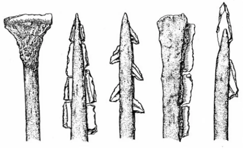
The lack of large projectile points has led to several different conclusions. One is that the inhabitants of the site lived before the time of arrowheads. Another is that something else substituted in their assemblage for arrowheads. The excavator suggests that the scalene triangle geometrics may have been used in place of
arrowheads (Rosenberg 1994a: 237) [Fig 3]. Yet another possible replacement is the sling ball. The conclusion of Korfmann’s 1972 dissertation was that the use of either sling balls or arrowheads as long-range projectiles was exclusive over the course of several millennia in the Near East (Korfmann 1973: 42). Sling balls, made from water-worn stones, can only be identified by archaeologists when many are found cached together, with no evidence of other use such as battering
(Korfmann 1973: 38). Small caches of balls have been recovered from Hallan Çemi, though their use as sling balls or bolas is still debated.
Figure 3 Possible ways microliths could have been mounted as projectiles
Microliths
It was previously thought that the hallmark of the Epipaleolithic was the addition of backed, retouched microliths to the toolkit. However, this has been debunked by the discovery of backed and retouched microliths in an Upper Paleolithic context, as well as sites dated well within the Epipaleolithic span of 10,000 years that have very few of this “diagnostic” type (Byrd 1994: 206). This has led some to deem the use of the term Epipaleolithic outdated (206). It is not simply the presence of microliths, which continued throughout the entire Neolithic, but the absence of big blades that is used to date, characterize or define a site.
The microliths recovered from Hallan Çemi are almost entirely geometrics, with the sporadic backed bladelet, a single microburin and a few fully backed
ovates (Rosenberg 1994a: 230). Despite the preponderance of microlithic tools, it is unlikely that the overall industry at Hallan Çemi should be called microlithic (237). Both geometrics and other blade tools appear in full-sized forms, and the majority of microliths were made of obsidian (237). This is important because obsidian was a valued resource, used preferentially for the creation of blades. Thus were a blade to have been damaged, its reuse in a smaller form was guaranteed. To reiterate; it was not the size that was preferred, but the material, and this alone led to the smaller size of many tools.
Even if the intensively exploited obsidian was not enough to explain why the assemblage is not Epipaleolithic in character, microliths were recovered from many other Anatolian sites fully within the Neolithic. They were found in all levels of the PPNA-B site of Çayönü, further along the Tigris (Caneva et al. 1994: 263). At Cafer höyük during the early phase, a third of all retouched tools were
microliths, and included some geometrics (Kozlowski 1999:110). Microliths also appeared in 3 of the 5 late phases of Cafer höyük and also at the early PPNB site of Nevalı Çori (Özdoğan and Balkan-Atlı 1994: 206).
Geometrics
At the end of the Epipaleolithic (c. 9th mill. bc) microliths all over the Near East become more geometric with the appearance of lunates, crescents and trapezes (Kozlowski 1994a: 145). Lunates and backed pieces with truncations appear in the Zarzian industry; triangles appear in the Natufian; crescents, double truncations and trapezes appear in the Caucasian-Caspian province; and isosceles triangles appear at
Öküzini (145). During the Protoneolithic (c. 9th-8th mill. bc), geometrics disappear from the Natufian and very early on at Mureybet; scalene triangles appear at Öküzini; and the same geometric forms of the Zarzian are repeated in microlithic dimensions (145). This is perhaps a result of a change in core technology, from the use of hammerstones to punch and pressure flaking (Olszewski 1994: 86).
The geometric pieces of the early Natufian are mostly lunates (Akkermans and Schwartz 2003: 26). Geometrics, though few, from Zarzi and Warwasi are largely scalene triangles, though Warwasi produced a few isosceles triangles and convex pieces, such as lunates (Olszewski 1994: 86). Geometrics from sites
classified as having Trialetian industries are dominated by trapezes until c. 7,500 bc (Kozlowski 1999: 140). Belt Cave, south of the Caspian Sea, produced one short scalene triangle between 9,500 and 7,500, but from 7,500 bc to the end of the 7th millennium triangles and pen-knives joined the trapeze-dominated assemblage. Another Trialetian industry, that at the undated site of Dam Dam Cheshme east of the Caspian Sea, produced only trapezes and short triangles in the lowest levels, and only in the uppermost levels did any elongated triangles appear (145).
Of 135 total geometrics recovered from Hallan Çemi, 129 were in the form of elongated scalene triangles. The other six pieces were convex (Rosenberg 1994a: 230). This is most similar to the upper levels of Dam Dam Cheshme and Belt Cave, though they are over a thousand kilometers [Fig. 2] and at least a
thousand years apart. In the later, ceramic levels at Çayönü, geometrics in the form of rough lunates appear (Özdoğan 1994: 272).
Obsidian
In general, the presence of obsidian is a good chronological marker. The more obsidian found at a site, the more likely the site will be dated after the
Aceramic Neolithic (Hole 1994b:113). Obsidian from Hallan Çemi was identified by its trace elements as having been brought from the Nemrut and Bingöl A and B sources, each 100 km from the site (Rosenberg 1994a: 225). Despite the lengths traveled over rugged terrain to reach this raw material, more than half of the 4,340 pieces examined in 1994 were of obsidian (225). The intensity of obsidian use can be understood as obsidian accounted for only a third of the total chipped stone by weight, despite the great number of pieces; and also as far fewer obsidian pieces were left without retouch than those of flint (225). Obsidian was also prefer- entially used in the manufacture of certain tools. Nearly all of the blades were made of obsidian, and 2/3 of all blade cores were obsidian, all of which had been exhausted (225).
Obsidian is rare or even absent at Zagros Protoneolithic sites, which are at least 500 km from obsidian sources [Fig 2]. The obsidian that is seen, has been traced to the Bingöl sources (Sherratt 2006b: np). Obsidian only appeared in the Levant and Syria at the very end of the Natufian period (Akkermans and Schwartz 2003: 82). The obsidian sources exploited by those in the Levant were largely from Cappadocia, with very little from the Bingöl area in the PPNA, and with increasing amounts in the PPNB (Sherratt 2006b: np). A further tie between the Zagros ‘hilly flanks’ and Hallan Çemi is seen in the obsidian sources that both exploited.
Conclusion
In sum, while the presence of microliths could lead to the conclusion that Hallan Çemi should be dated to the Epipaleolithic, it has been shown that the smaller size of many points was due to intensely utilized obsidian, which itself is characteristic of the Ceramic Neolithic.
Hunters are conservative, having stable lithic industries, and tend to attain raw materials from the same sources (Kozlowski 1999: 25). Another tendency that leads to conservative or unchanging technology is isolationism (29).
It is clear that the Zarzian tradition of an assemblage with a high proportion of tools, of which nearly half were microliths traveled northwest along the Tigris from Zarzi to Zawi Chemi Shanidar and then to Hallan Çemi, and the conservative style of hunter gatherers led them to both reuse obsidian, a highly prized resource for blades, and resist new technologies.
It is not strange to suggest that different elements spread at different paces through different communities, and thus the appearance at Hallan Çemi of a Trialetian-like industry. The geometric forms may have trickled down through the mountains, but it is nonsensical to assume they arrived from the north a thousand years before they appeared at their site of origin. It is easier to conclude that the scalenes from the earlier site of Zarzi and the crescents from Zawi Chemi Shanidar evolved into the geometric assemblage of Hallan Çemi.
Even though the utter absence of big blades and prominence of microliths argues for an Epipaleolithic date for the assemblage, the high proportion of obsidian and the favored type of geometric (scalene triangle) appears to be evidence for a
later date. The site of Hallan Çemi could easily have been an outpost for a population resistant to the Neolithic, living amidst many groups that had already begun the transition to an agricultural economy.
CHAPTER 3
Ground Stone
The ground stone assemblages of Hallan Çemi have been likened to those from the Zarzian Epipaleolithic by Rosenberg (1999: 29), as well as those from Southeastern Anatolian PPNB sites (Özdoğan 1999: 228). However, providing a chronology for these assemblages by themselves presents quite a challenge. Chipped stone assemblages are often dated by the presence or lack of “diagnostic” elements. This unfortunately is not true of ground stone assemblages, which are often only described briefly. One might posit a generalization that “chisels appear after hammers” but this is not used for dating an assemblage. In order to place the material culture from Hallan Çemi chronologically, I will first describe the
assemblage and attempt to identify the more salient points for comparison and then describe the differences and similarities between non-ubiquitous forms with finds from other Near Eastern sites.
Hallan Çemi
The ground stone assemblage from Hallan Çemi has several remarkable characteristics. As a whole, it consists of well over 1,400 objects, including: pendants, beads, vessels, pierced and semi-pierced stones, mortars, querns, pestles, mullers, grooved stones, notched batons, slingstones and small stone plaques similar to stylized bucrania. Certain objects, such as beads, pendants, utilitarian pestles and pierced stones, are so broadly distributed among Neolithic sites that it is not within the scope of this chapter to discuss them but briefly. Spherical limestone artifacts thought to have been used as slingstones or as bolas were also recovered at most of these sites, such as Demirköy and Nemrik. Most striking in comparison with other sites along the Tauros-Zagros arc is the utter lack of heavy wedge scrapers such as celts or adzes (Rosenberg 1991: 119)1. Indeed, large artifacts are rare. Mortars are few compared to the preponderance of their counterpart grinders. However, this dearth of mortars is seen along the Taurus-Zagros arc in conjunction with a large number of extant pestles and is therefore not specific to the site of Hallan Çemi. It has been suggested that mortars were more efficacious for pounding nuts and querns for grinding seeds. However, the higher preponderance of querns at Hallan Çemi is puzzling in light of evidence that nuts and pulses played a more significant dietary role than small-seeded grasses (Rosenberg et al. 1995: 7). The percentage of seed remains at Hallan Çemi is dominated by two genera (60%), followed by legumes (Savard et al. 2006: 190). This predominant reliance on neither nuts nor seeds may have led the population to favor neither querns nor
mortars, but to consider all such equipment as multi-functioning. Additional evidence for this might be seen in the re-use of handstones as nutting stones (Rosenberg et al. 1995: 6).
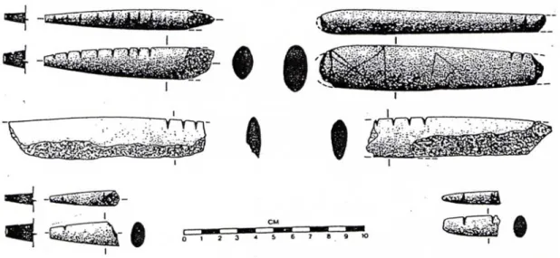
The presence of highly decorated objects sets Hallan Çemi apart from other early sites in Iraq and Southeastern Anatolia. Even some of the pierced stones appear to have been ornamented (Rosenberg 1999: 28). Nearly a third of all pestles recovered were fancy, with straightened shafts and/or decorated finials (Peasnall 2000: 166). Hundreds of fragments of stone bowls with incised decoration and perforated rims were unearthed, as well as “notched batons” – wands of stone with tapered ends and perpendicular notches thought by some to be used for tallying purposes (Rosenberg 1994: 82).
Vessels
At Hallan Çemi, several hundred fragments of vessels were recovered. Most bowls were made of a dark chloritic stone; often grey, green or black in color. Various motifs of incision appeared on some of these bowls, including:
crosshatching, meanders, zigzags, nested crosses and even a specimen that appears to be decorated in low relief with serpents (Rosenberg 1999: 28). Other, less abstract, incised decorations include canids [Fig. 4], serpents and floral
representations. Most vessels are round and flat-based, with a diameter of less than 20 cm (Rosenberg and Davis 1992: 4-5). There was also evidence for larger
limestone vessels, with less effort put into their manufacture. Both evidence of repair and the presence of roughed out blanks led to the conclusion that the vessels were produced on-site (Rosenberg 1995: 11).
The earlier site of Zawi Chemi Shanidar has produced but one fragment of a quartzite vessel, though beads were recovered in a chloritic stone similar to that used at Hallan Çemi for vessel production (Peasnall 2000: 109). The roughly contemporary sites of Karim Shahir and M’lefaat in Iraq have produced one and three fragments, respectively. The single fragment from Karim Shahir is thought to be of a later date, as it is from a very fancy, small and incised steep-sided plate (218). The three fragments from M’lefaat come from oval-shaped, rimmed vessels (392). The slightly later site of Nemrik 9 has produced fragments from four polished, but otherwise undecorated vessels. A deep, semi-spherical bowl with a diameter of about 14cm was made from white marble, while the other, larger, fragments came from vessels made of pink and white sandstone (441-2).
Bowls have been found at many later Central Anatolian sites, but few sites approach the abundance with which they were recovered at Hallan Çemi.
Fragments of decorative vessels made of the same dark chloritic stone were recovered from the contemporary (or slightly later) round house subphase at Çayönü, and again from the Grill plan subphase (Özdoğan 1990: 59). These
vessels, though larger and less abundant than those at Hallan Çemi, are their closest analogues. Incision and low relief were used to decorate these specimens. Also as at Hallan Çemi, a light-colored limestone was used for the production of
undecorated, utilitarian vessels.
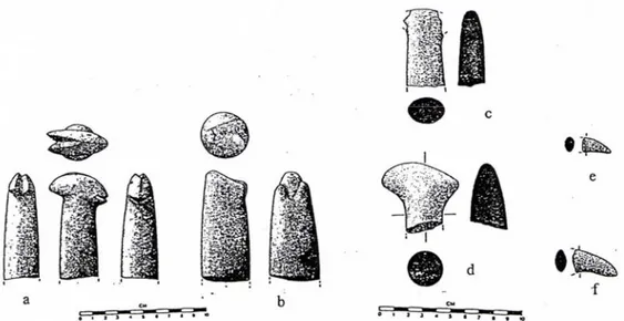
Fancy Pestles
Of a stunning 354 pestles recovered from Hallan Çemi, 118 were classified as fancy, some of which had sculpted finials. These pestle fragments ranged in size from a few centimeters to 20 cm long. The finials were decorated with a variety of motifs: goat heads [Fig 5-a], down-curving barbs [Fig. 5-c-f], and what may well be a pig [fig 5-b].
Although utilitarian grinders were recovered from every site, those with which extra care had been taken to shape, straighten and even polish the shaft were found in a limited context. Some of these pestles had sculpted finials with
zoomorphic or anthropomorphic representations. Fragments of shaped pestles with long, straightened shafts appear in small quantity at the upper layers of Zawi Chemi Shanidar and Karim Shahir (Peasnall 2000: 115, 396). Four “rod” fragments from M’lefaat may also be shaped pestle shafts (396).
Of over a thousand total pestles recovered from Nemrik 9, 25 had inordinate care taken in their manufacture, with straightened sides and sculpted finials
(Mazurowski 1997: 129). Most of these came from the upper two levels, with only 3 examples from the first three occupation levels. Four of the total depicted
anthropomorphic features: three heads and one mid-section with a sculpted buttocks from the middle of a pestle. Of the heads, the earliest is from the floor of house 6 in occupation phase II (131-2). The buttocks was found at level IV, and the remaining two heads came from a fill of level IV, and should probably be associated with level V. Of the remaining 21 zoomorphic representations, four have roughed-out finials that appear to have been abandoned during the manufacturing process. The earliest identifiable pestle is ornitomorphic in character and found in level III (134-5) [Fig
6-a]. The thick down-curving beak is separated on both sides by an up-curved
incision, and the eyes are represented as flat circular protuberances. Level IV produced pestles in the shape of a panther head, a ruminant leg and two more bird representations. As the first two forms are unknown from Hallan Çemi, I will only describe the birds, which may be related to the down-curving barb shapes. One of these is little more than a vaguely-shaped water fowl [fig 6-b], while the other [fig 6-c] has a well-defined head, circular hollows for eyes, beak division split with a
flint tool, and two oblique lines between the eye and upper beak (136). Of the various representations, birds, likely rooks or crows, dominate, [6-d, e] and are generally less stylized and of a higher quality that those of Hallan Çemi.
Figure 5 Zoomorphic pestles from Hallan Çemi.
In Anatolia, fancy pestles are less abundantly seen. Two polished shafts and one finial were recovered from the Cell Plan subphase at Çayönü (Peasnall 2000: 312). Aslı Özdoğan (1999: 59) suggests that, since pestles and bowls were found in a PPNA context at Hallan Çemi and in a late PPNB context at Çayönü, this is evidence for their special status as heirlooms and retention over generations. Far and away the largest numbers of shaped and decorative pestles (after Hallan Çemi) come from the nearby site of Demirköy and from Nemrik 9 in the Mosul region of Iraq.
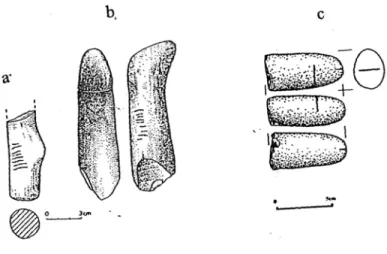
Elongated stones: notched and grooved
An interesting class of items called “grooved stones” is thought to have been used as shaft straighteners. These are formed from elongated river pebbles and have a “U” or “V” shaped incision, often polished from wear. The grooved stones from Hallan Çemi are all characterized by the “U” shape, as is the single example from Mlefaat (Peasnall 2000: 222). Other sites have a mixed assemblage with both “U” and “V” shaped grooves. The V-shaped grooves are found at Zawi Chemi Shanidar, Demirköy höyük, Çayönü, and Nemrik 9 in conjunction with “U” shaped ones (Peasnall 2000: 113, 222, 309, 444).
Perhaps appended to this group are the “notched batons” that appear only at Hallan Çemi and Demirköy, 40 km to the south [fig 7]. These artifacts are
fragmentary, none longer than 10 cm, with at least one tapering edge. Anywhere from one to eight transverse notches appear in a line. Vaguely similar stone
objects, though truncated, have been recovered from Nemrik 9 [fig 8]. Smaller examples of chloritic pebbles with etched lines have been recovered from Zawi Chemi Shanidar (Solecki and Solecki 1970). These take many different forms, but are generally much smaller and of a different shape than the carrot-shaped items from Hallan Çemi. Notched bone awls from late Kebaran sites are also known, those from Jiita and Ksar Akil (both near Beirut) were marked with grouped transverse incisions (Moore et al. 2000: 163).
As for the notched batons, any number of wild speculations could be made about these artifacts. Perhaps they represented a phallus, and for every new
summer of a young boy’s life, a notch was carved until the festival of circumcision. Or perhaps these batons were used for the same administrative purpose as clay tokens, though by a people who did not use clay. In any case, no verdict can yet be reached.
Figure 8 Notched pestles and phallus from Nemrik 9
Discussion
As the similarities between the ground stone artifacts from both Zarzian Epipaleolithic and Southeastern Anatolian PPNB sites have been demonstrated, it remains to be seen if there is any evidence for other elements that may have
influenced or have borne the influence of the populations that lived at Hallan Çemi. Simply looking at a map [fig 2] it is easy to see a line curving along the Tigris, between the sites nestled on tributaries, ultimately penetrating central Anatolia. Perhaps it is no coincidence that the evidence for settlements flows against the river
inquiry are the southeast, the middle Euphrates region down to the Levant and the northwest, through mountain ranges to the Caspian region.
The Mesolithic sites in the southern Caucasus had very roughly worked ground stone implements until the late Neolithic, when drilling and polishing was mastered (Kushnareva 1997: 16). This late appearance of a ground stone industry in the southern Caucasus is thought to be due to a late influence from southwest Asia (16).
From the Levant, the Natufian ground stone includes both stone bowls (sometimes engraved) and pestles ending in a hoof (Akkermans and Schwartz 2003: 27). The late Natufian settlement at Abu Hureyra, which was founded around 11,000 BC, has produced many ground stones items, and though some were roughly shaped, none were as polished as those found from Hallan Çemi. Of the 147 stone artifacts recovered from the oldest building level, 3 were fragments of basalt vessels (Moore et al. 2000: 173). Of the three, the outside of one was decorated all over with cross-hatched lines and had evidence of holes for suspension and of burning underneath (173).
It is clear, then, that the technology of making polished stone vessels and pestles was brought from Zarzian Epipaleolithic sites to Hallan Çemi, and thence to central Anatolia. In general, the pestles and bowls found at sites earlier than Hallan Çemi are less fancy. The sole exception is the more naturalistic (and
anthro-pomorphic) assemblages found at Nemrik 9. The greater intricacy of the pestles at Nemrik 9 could be explained as a result of return migration of a part of the
The function of these vessels remains to be seen. It has been suggested that, due to the effort spent in polishing chlorite bowls and pestles, these artifacts were endowed with a ritual significance (Rosenberg, Özdoğan, etc). Other scholars have denied the ritual use of these by pointing to both their re-use and their placement in dumps, fills and pits (Mazurowski 1997: 130). The intentional destruction of vessels by punching out the bottom can be seen as support for both positions. Vessel parts re-used in the walls of later building levels points to their utilitarian function. Certainly whapping a hole in a stone is more fun than continuously bringing rocks up from the river or dragging them out of fields. Mazurowski (1997: 151) has suggested that vessels were destroyed upon the death of their owner. This conflicts with Özdoğan’s theory that the vessels were passed on as heirlooms (1999: 59). More evidence contrary to the idea that vessels were destroyed in mourning is that large numbers of utilitarian querns and mullers that show evidence of
intentional destruction were found at sites in northern Iraq and southeast Anatolia. Perhaps with the common destruction and reuse there is a chaine operatoire of ground stone as well, from bowls and querns to pestles, notched batons and pendants.
Conclusions
Instead of a ritual use for the polished vessels, perhaps they were used for storage. The holes pierced near the rims of many vessels indicate that the vessels were suspended or covered with hides, and, in the absence of storage facilities of any type, could easily have been used in their stead. The fancy pestles created from
the same dark chloritic stone may have been used in conjunction with the bowls (Rosenberg 1999: 28), but the pestles chosen to have extra care put into their creation could have been due to the lovely color and ease of shaping. The separate use of pestles and vessels is supported by evidence from Nemrik 9, where many fancy pestles were recovered, yet only a few fragments of vessels.
The designs etched and carved into stone are very similar to those found at Nevalı Çori and Göbekli tepe. The canid, with its upswept tail reminds one both of the curved wolf-like creature from Göbekli (after Hauptman 1999: Fig 30) and an incised limestone plate from Nevalı Çori (Fig. 17). The wiggly snake motif with its peculiar triangular-shaped head, carved in bone several times at Hallan Çemi, is seen variously at both sites, on sculptures and T-shaped pillars. The iconography and raw material of the ground stone from Hallan Çemi is certainly more similar to sites in Anatolia during the 10th and 9th millennia BP than to any Epipaleolithic site.
CHAPTER 4
ARCHITECTURE
Having discussed the portable material culture, I will proceed to the architectural elements of Hallan Çemi. I will first describe architectural features associated with each level: platforms, plaster features, hearths and structures and then place them in relation to each other. I will describe the building levels and then evaluate each building level in terms of the four observable aspects of architecture: construction technique, architectural form, permanent internal features, and roof support (Kozlowski and Kempisty 1990: 352). I will conclude with a discussion and comparison with structures from other sites, as architecture can be used to provide general dates timeframes. For example, it has been proposed (Flannery 2002: 421) that the round shape of a house was a feature of the Natufian
Description
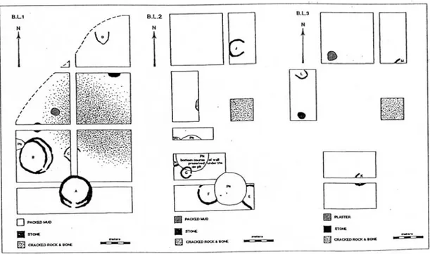
During the excavation, four building levels were discovered that could be attributed to the Aceramic period. Unfortunately, only the upper three were excavated (Rosenberg 1999: 26). Common to each level was a central open
depression replete with fire-cracked stones and animal bones. The c. 15 m area was used both as a place for refuse disposal and for temporary hearths. Circular
platforms were arranged around this area, made variously of stone, packed mud and plaster2. These platforms were c. 2 m in diameter and rose to a preserved height of 10-40 cm. Rosenberg, the excavator, hypothesized that these were foundations for storage silos, as no storage pits were found. Other features included low raised plaster hearth boundaries, with fire-cracked rocks inside, approximately 50-70 cm in diameter. These plastered rings were found both inside and outside of structures (Rosenberg 1999: 25). Large irregular lime plaster expanses, associated with the outside of structures, were discovered in addition to postholes. Thousands of fragments of burnt mud with impressions of wood led excavators to believe that wattle and daub was used for building superstructures in all levels.
Building Levels [Fig. 9]
The structures from the lowest building level are U-shaped in plan, and built directly on the ground. The walls are built of coursed river cobbles adhered with plaster, and the floors are unpaved (Rosenberg 1999: 27). Three such structures exist, to the north, northwest, and south of the central depression (Rosenberg
2 Özdoğan (1999: 288) has claimed that lime plaster was used at Hallan Çemi, while Rosenberg
refers to mud plaster used to seal raised platforms (1999: 26). Peasnall (2003: 150) describes the external plaster floors as lime plaster. These appear in all three excavated building levels.
1995:10). The northernmost structure, 3C (or M), is very close to the edge of the depression, while 3B (or L) lies some 15 m west of 3C, and c. 7 m from the edge of the central pit (after Rosenberg 1995: 14, Fig.1)3. The southernmost structure, 3A (or K), also lies c. 7 m from the edge, approximately 20 m from 3B and 3C. Approximately five meters to the northeast of 3B (aka L), lies a roughly square plaster feature 2-3 m in diameter (after Rosenberg 1999: Fig.2). Seven meters directly south of the same structure lies a stone platform 1-2 m in diameter. It is essentially a ring of flat stones set on edge, filled with mud and covered with flat stones.
Figure 9 Excavated building levels at Hallan Çemi.
The second building level has a total of five structures, four of which were completely excavated. All five are surface structures, and all five are constructed using the same plaster-mortared cobbles as the previous building level. Three of the excavated four had floors paved with sandstone slabs. The fourth, however, was unpaved. Structure 2C (or J) lies 5 m north of the central depression, and 2 m northwest of the northern structure from the lowest building level. It is nearly a perfect C-shape, with a diameter of 3 m, and an opening to the east. The floor is unpaved. The unexcavated structure, E, was not mentioned in the 1995 report, though it appears to be 4-5 m and U-shaped. Its northwestern corner was destroyed by the pit for the overlying building (1A or A). Also partially destroyed by the same pit, albeit to the west, is structure 2A (or F), a round building 4m in diameter with a floor paved with close-fitting slabs of sandstone. Building 2A (F) is
distinguished both by layers of plaster over the flagstone, and by a plastered basin in the center (Peasnall 2003: 53). Both structures E and F are approximately 5 m south of the central area. Two meters northwest of structure 2A (or F) lies another, smaller circular paved structure. The bottom course of the wall of 2B (or G) was preserved under the pit for the overlying structure (1B or B). Only one meter of curving wall was uncovered of structure 2D (or H), as the rest was under either the baulk or structure B. This, too, had a paved floor. Approximately 2 m west of the central pit, and 7 m north of G, lies a packed mud feature with a diameter of 2-3 m.
The uppermost building level has four excavated structures, all of which are constructed from sandstone, not river stones. Two are U-shaped surface structures, and two are fully round buildings with a doubled wall at the entrance. Structure 1D
(or D) lies 7 m north of the central depression with an opening facing north. 5 m to the south of D is a stone platform, near the edge of the central depression. Fifteen meters southeast and across the central pit is a structure shaped like 3 sides of a square, with the southwest side open. 1C (or C) is approximately 2 m along each side and unpaved. Two meters south of C is the northernmost point of building 1A (or A), with an opening facing south. Three meters to the northwest lies building 1B (or B). One meter north of B is another stone platform, c. 2 m in diameter, and 3 m to the northeast of the platform is another, of packed mud, fully within the central depression. Buildings A and B are both 5-6 m in diameter, with circular walls of limestone slabs c. 10 cm thick with a related exterior about 50 cm higher than the interior. Each has a semi-circular stone bench or platform against a wall, doubled walls at the entrance, and the floors were resurfaced numerous times with yellow sand and plaster. House A was fully excavated during the 1992 season. The interior walls are preserved to a height of c. 1 m. At six points along the wall there are vertical gaps of 10 cm, presumably for vertical poles. There is also a collapsed stone feature in the very center (Rosenberg 1993: 124-5). House B was fully excavated the following season, and the stone feature in its center was intact. It consisted of three squared sandstone slabs set on end to make a U shape (Rosenberg 1993: 125). It is thought that this served as a footing for a central post to support a roof (Rosenberg 1994b: 80).
Synthesis
Construction technique and architectural forms are identical for the lower two levels: U-shaped surface structures made from river cobbles mortared with plaster. Permanent internal features appear in the second building phase, with paved floors and a central plastered basin. No evidence for roof support yet exists. By the most recent building level, evidence exists that the builders’ approach has changed. A new type of structure exists: the semi-subterranean round house. These houses are constructed with sandstone slabs, and the floors were resurfaced many times. Permanent internal features include benches and storage areas, and evidence for a support system for a roof exists.
Discussion
What, then, could be the cause of this change between the uppermost building levels? Could there have been a great lapse in time between levels? To answer this, the uses of the different structures must be considered. The excavator concluded that all of the structures 2 m in diameter and larger were houses used by a permanently settled population, and the largest buildings of the uppermost building level were used as public buildings. To support this claim, he cites the domestic materials found associated with these structures.
The structures from the lowest level are only preserved to a few courses of mortared river stones. If these are truly houses, one must wonder what happened to the rest of the walls. Published pictures do not show any fallen rubble around these, and therefore, it seems safe to conclude that these foundations were only built a few
courses high. This symbolic boundary would not even contain a child, and yet it seems people did inhabit these structures. Some sort of perishable material or combination of materials must have served for the superstructure; the leather or cloth of tents, or a more permanent light wall of wattle and daub. In any of these cases, one would expect evidence of post holes. These were found in the southern part of the excavation, in the levels below the semi-subterranean buildings, most likely because the deposits there were less rocky than in other areas. However, the excavator avers that the few found were only a tiny fraction of what really existed (Rosenberg 2007: personal communication).
Building Level 1
One option is that these U-shaped structures were used as temporary weights for tent edges. This is seen in areas with high winds. At Hallan Çemi there is a strong catabatic wind, which becomes more intense at nightfall. At times, it was impossible for the excavators to sleep outside, both due to the roar of the wind and the mattresses (with sleeper!) being lifted up (Rosenberg 2007: personal
communication). This fierce wind could be the reason for both setting down rings of stone and later mortaring them.
Another option is that these U-shaped structures may have started off as storage for querns or large objects during the seasons when the population followed herds and only later adapted for residence. Mobility of the population is implied by the depth and contents of the central depression, around which the U-shaped
rocks and bones into the hollowed area, the deliberate placement of three bucrania as well as the articulated remains of butchered animals suggest otherwise. It seems this site was a favored campsite for many groups over a long time, as the contents of the depression extend below the building levels.
The three structures from the lowest building level, arranged in a rough triangle around the central activity area at distances of 15-20 m away from each other, were built with each opening facing a different direction. Only K faces the central pit, and on the basis of this, I suggest that it was the first construction. After the abandonment of K, perhaps many decades passed before another group arrived at the site and decided to imitate the mortared construction, yet did so in a non-threatening manner, in case the builders of K should return.
Another option is that the group was large enough to require several structures. However, determining if the structures were contemporary requires micro-stratigraphical analysis that was not possible during the salvage excavation. This arrangement of structures situated around a central working area is similar to arrangements of tents in a campsite, as well as to the earliest composition of structures at Çayönü (Özdoğan 1999: 43). At Çayönü, however, the central
working area was only 4-5 m in diameter, while that at Hallan Çemi was over three times as large (43). The structures themselves resemble the curved footings of tents built by modern nomads to protect against wind and cold (Cauvin 2000: 192, Fig. 67).
Building Level 2
In the second building level there are more structures around this depression, and with smaller openings. The types of structures, however, are essentially the same. Some of the structures in the second building level appear to be rounder in shape. The only addition is a paved floor, which I shall return to in more detail. There is nothing to suggest that the buildings were being used for different purposes than before. It is only in the most recent building level that a concerted effort is made to contain a group of people. A new form of architecture is observed: a building you must step down into. This is similar to the shape of the central depression, and reminiscent of being protected in a mountainside glen.
Other possible uses for these structures include storage and workhouses. Rosenberg noticed that no pits for storage were evident, and hypothesized that the plaster expanses were used as such. The smaller and earlier structures could have been used for storage of plant food, and indeed plant food remains are found
associated with these buildings more than the large rooms of the final building level (Rosenberg 1994b: 81). Perhaps none of these structures were used as houses until the winter snow, when the inhabitants may have been far away. Natufian
settlements have pits.
A building with a paved floor is again seen at Çayönü, albeit in the third building stage (later PPNB) (Özdoğan 1999: 51). Even the plastered floor has an analogue during the end of the round house phase there (Özdoğan 1999: 43). The floors and walls of structures during the Middle phase at Nemrik 9 were plastered
with clay, and (unlike Çayönü) pits and hearth were dug into the floors in all levels (Kozlowski and Kempisty 1990: 532-353).
Building Level 3
The larger, more circular structures found only in the most recent level at Hallan Çemi have similar shapes and sizes as those found during the Iraqi PPNA at Nemrik, Mureibet and Gilgal (Kozlowski 2006: 43). These are quite similar to the base-wall circular structures of the hunter-gatherer camps of the European
Gravettian4, in that the sizes of the villages, the number of houses per village and the great quantity of lithic material recovered are similar (50).
These larger buildings might have instead acted as workrooms, for the larger structures have the largest obsidian cores, as well as concentrations of chipping debris. On the basis of this, Rosenberg proposes that the larger buildings were public (1999: 27). There is much discussion of “public” activity in the literature, yet when groups are small families, it would seem as though most activity is public. Public/private only becomes an issue when single-family groups are no longer.
Only by the most recent building level is the assumption that buildings were meant for permanent habitation acceptable. Increased planning evident from the shaped sandstone used for structures and the gaps for roof support indicate that life focused more on existence within the area.
Another point of departure from the previous building levels is the
placement of an aurochs skull that, due to its “nose-down” position, may have fallen
4 The Gravettian is an Upper (late) Paleolithic industry that takes its name from a point type. The