Journal of Coastal Research 29 1 78-85 Coconut Creek, Florida January 2013
Depositional Characteristics of Carbonate-Cemented Fossil
Eolian Sand Dunes: Bozcaada Island, Turkey
Ahmet Evren Erginal^, Yunus Lèvent Ekinci*, Alper Demirci% Mustafa Avcioglu^ Muhammed Zeynel Öztürk% Murat Türke§^ and Erdinç Yigitba§*
'Ardahan University Department of Geography TR-75000, Ardahan, Turkey [email protected]
•Çanakkale Onsekiz Mart University Department of Geophysical Engineering 17020 Çanakkale, Turkey
www.cerf-jcr.org 'Çanakkale Onsekiz Mart University Department of Geological Engineering 17020 Çanakkale, Turkey
ABSTRACT I
www.JCRonline.org
Erginal, A.E.; Ekinci, Y.L.; Demird, A.; Avcioglu, M.; Öztürk, M.Z.; Türke?, M., and Yigitbaç, E., 2013. Depositional characteristics of carbonate-cemented fossil eolian sand dunes: Bozcaada Island, Turkey. Journal of Coastal Research, 29(1), 78-85. Coconut Creek (Florida), ISSN 0749-0208.
Coastal eolianite on the south coast of Bozcaada Island, Turkey, was investigated hy field observations, pétrographie and elimatological examinations, and electrical resistivity tomography data. The 4- to 7-m-thick eolianite, including rhizolith morphotypes characterized by root tubules and bifurcated root casts, demonstrates dune-sand accumulation during the Upper Pleistocene. Our results showed that paleowind drift and recent windblown sand drift on the island are similar. The dune sands exhibit various cement types formed of ealcite and aragonite, such as micrite encrustations, meniscus and gravitational cements, and in particular, void fills. Dune-sand accumulation took place on the truncated surface of Miocene deposits. Geophysical data showed the existence of large weathered cavities within the eolianite and a high-angle normal fault, which displaces the eolianite, together with the underlying Miocene unit.
ADDITIONAL INDEX WORDS: Eolianite, rhizolith, electrical resistivity tomography (ERT), windblown sand drift,
Upper Pleistocene, Bozcaada Island, Turkey.
INTRODUCTION
Coastal eolianite is a kind of carbonate-cemented sand-stone that forms as the result of cementation of dune sands by a predominantly calcium carbonate material mostly drifted by offshore winds. A number of previous publications showed that these rocks are, to a large extent, of Quaternary age with a global distribution (Fairbridge and Johnson, 1978; Thomas, 1997) and were formed during both low and high stands of the global sea level. From the sedimentological point of view, moderate-to-hard cementation, cross-bedding (Frébourg et al., 2008), and rhizolith content as organosedi-mentary components (Klappa, 1980) are some common properties of those eolian occurrences. Based on the preceding attributes, eolianites provide sound evidence of multifarious dune generation in coastal environments (Brooke, 2001). The significance of eolianites in explaining the dynamics acting on paleocoastal environments during the Late Quaternary-Holocene has already been proposed (Kelletat, 1991; Woodroffe et al., 1995). Since Darwin's (1851) first observations, detailed discussions of early concepts on glacial and interglacial eolianites were provided by Fairbridge (1995) and Brooke (2001).
However, knowledge so far has been scanty regarding the presence of eolianites on Turkey's long (8333 km) coastline. A preliminary assessment of the studied eolianite with regard to
DOI: 10.2112IJCOASTRES-D-11-00100.1 received 10 May 2011; accepted in revision 9 October 2011.
© Coastal Education & Research Foundation 2013
its main pétrographie characteristics and optically stimulated luminescence estimations was made previously by Kiyak and Erginal (2010). Within the scope of this multidisciplinary study, however, we discuss the bedding characteristics and subsurface nature of carbonate-bearing Pleistocene eolianite on the south coast of Bozcaada Island, Turkey (Figure la). Several microfacies and structural characteristics and the subsurface nature of the studied carbonate dunes are discussed on the basis of field observations, as well as microanal3'tical and electrical resistivity tomography (ERT) data.
GEOLOGY AND CLIMATE
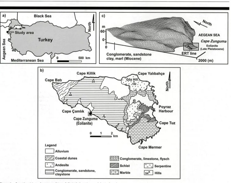
The geology of Bozcaada Island is complex, considering it has a Mmited (36 km^) surface area. Pre-Tertiary basement rocks exposed on the SW part of the island are made up of metamorphics, such as marble and schist, and ophioliths (Erguvanli, 1955; Saltik and Saka, 1972). The basement rocks are overlain by Eocene conglomerates that pass upward into limestones and flysch. Upper Miocene shallow marine sediments are the most extensive outcrop on the island (—40% of the surface area) and are composed of conglomerate, sandstone, and lime-stones, with some andesitic volcanic rocks (Figure lb). The eolianite that accumulated in the N 30° E-aligned Cape Zunguma is the only Pleistocene unit on the island (Figure lc) (Kiyak and Erginal, 2010).
The climate of Turkey is generally characterized as being of the Mediterranean macrocümate type within the subtropical belt (Türke?, 1998, 1999). This climate mainly results from the seasonal alternation of midlatitude frontal cyclones, characterized
a) AEGEAN SEA Cape Zunguma Eolianite I (Late Pleistocene) Conglomerate, sandstone clay, marl (Miocene)
2000 (m)
Cape Killik Cape Yalibahçe Cape Bati
Cape Zunguma^=S (Eolianite)
Legend I I Alluvium \/^A Coastal dunes I ' . ' I Andésite I I Conglomerate, sandstone, ' ' claystone Poyraz Harbour ^ Cape Tuz km Cape Mermer
[ : :.. 'I Conglomerate, limestone, flysch ^ ^ ^ Schist I^^'J Serpentine K ^ Marble ISA^ I Hills
Figure 1. Location (a), geology map (b), and digital elevation model (c) of study area.
by polar air masses and subtropical high pressures, with subsiding maritime tropical and continental-tropical air masses. According to data fi-om the Bozcaada meteorology station (1975-2005), the island receives an average annual precipitation of —465 mm. December corresponds to the rainiest month, with an average of 86 mm of rainfall, wMle the driest month is August, with an average rainfall of ~ 5 mm. The average annual mean temperature is ~15°C. According to Thomthwaite's moisture index (L,,,) (1948), a dry subhumid climate type is dominant at the Çanakkale and Bozcaada stations, while Gokçeada is characterized by a semi-humid climate. Reference to Thomthwaite's classification provides the following climatic description of Bozcaada: dry subhumid, second mesothermal throughout the year, and little or no water surplus during the year, with a summer concentration of thermal efficiency equal to a megathermal climate.
METHODS Sampling and Analyses
Standard pétrographie thin sections were prepared for pétrographie determination and then examined under a
microscope (CHEBIOS). A total of 10 samples were collected from the bottom, middle, and upper levels of the sequence for microanalytical examination. For chemical microanalysis and microfabric determinations, energy dispersive x-ray spectros-copy (XFlash, Bruker AXS), in conjunction with scanning electron microscopy (SEM; Evo 50 EP, Zeiss) was used. The total CaC03 content of samples was measured with a Scheibler calcimeter (Schlichting and Blume, 1966). From exposures of eolianite beds along the coastline, a total of 120 bedding measurements were carried out and then recorded with GPS to compare probable paleowind drift dynamics with those of the present.
ERT Field Survey
An ERT survey is a modified form of conventional verticEil electrical sounding and is used to obtain images of resistivity subsurface patterns in areas of complex geology (Griffiths and Barker, 1993). ERT can detect the resistivity properties of shallow regions to depths of several tens of meters or more and provide useful information for characterizing disparate
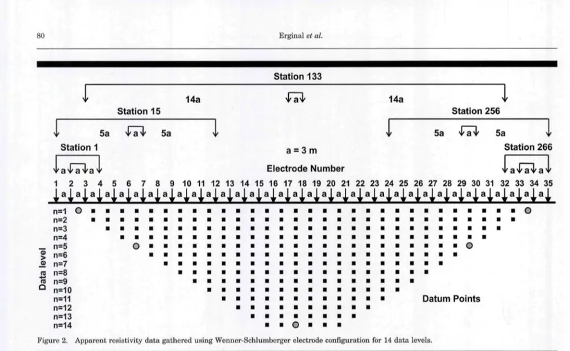
80 Erginal et al. y Station 133 14a 14a y Station 15 Station 256 5a 5a y 5a v a y 5a Station 1 a = 3 m Station 266 Electrode Number 1 2 3 4 5 6 7 8 9 10 11 12 13 14 15 16 17 18 19 20 21 22 23 24 25 26 27 28 29 30 31 32 33 34 35 n=2 a a a a a a n=3 a a a a a a a a n=4 a « . a a a _ n = 5 O a a a a a a « « B « « B a a a a a a a a a a O § n = 6 a n=7 • • • • a i i a a a a a a a a a a a a « n=8 • • • • • • • • • a a a a a a a a a n=9 a a a a a a a a a a a a a a a a <=> n=10 a a a n=11 • • • • a a a a a a a a Datum Points n=12 a a a a a 1 n=13 a a a a a a a « V n=14 a a O a a a
Figure 2. Apparent resistivity data gathered using Wenner-Schlumberger electrode configuration for 14 data levels. _
subsurface discontinuities, which can point to variations in the soil or bedrock lithology. Therefore, we carried out an ERT survey to delineate the subsurface geometry of the Upper Pleistocene eolianite, as well as its contact relationship vsdth the underlying Upper Miocene marine deposits. The apparent resistivity data were acquired along a survey line of 35 electrodes with a spacing of 3 m, giving a total length of 102 m. We gathered 266 apparent resistivity data using the Wenner-Schlumberger electrode configuration for 14 data levels (Figure 2).
Data acquisition was carried out using an Iris-Syscal R1+ resistivity meter. To enhance the quality of the apparent resistivity data, four vertical stacks were performed for each data point. Standard deviations were also checked during the measurements. When the standard deviation of the stacked data was greater than 3%, the resistivity meter performed three more stacks. This procedure was performed for only a few data points because the standard deviations were very low. Although the surface topography of the surveyed line is relatively gentle, topographic changes at the locations of each electrode point were determined by using the optical leveling technique for a more accurate approximation and interpretation.
The acquired apparent resistivity data were processed using RES2DINV software. The inversion algorithm (Loke and Barker, 1996) subdivides the subsurface into a finite number of rectangular cells that have constant resistivity and tries to find the resistivity values of the cells by reducing the difference between the measured and the calculated apparent resistivity values iteratively. Blocky or robust formulation that attempts to minimize the sum of the absolute (Abs.) values of the spatial changes in the model resistivity is more effective if the true subsurface resistivity consists of several regions that are approximately homogenous internally and separated by sharp
boundaries (Loke, Acworth, and Dahlin, 2003). In such a case, it is logical to select the robust inversion scheme to determine the layer boundary locations and layer resistivities more accurately (e.g., Loke, Acworth, and Dahlin, 2003; Olayinka and Yaramanci, 2000). Thus, the robust inversion scheme was used, because we expected that the resistivity contrast between eohanite body and Upper Miocene marine deposits would be significantly sharp and distinct. The inversion process pro-duced a model resistivity section after six iterations with an Abs. error of 3%. The maximum number of iterations was not increased to avoid overfitting of the data. The percentage differences between the logarithms of the measured and those of the calculated apparent resistivity values were very small (close to zero) except for a few data points. Thus, it can be considered that the inverse resistivity section approximates the actual subsurface structure.
RESULTS Faciès Characteristics of Eolianite
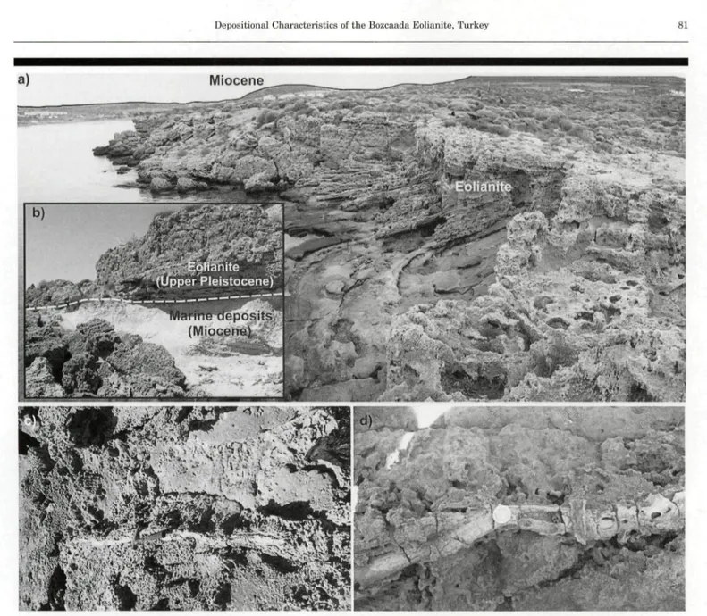
The studied fossil dune deposit comprises a unique Upper Pleistocene rock unit on Bozcaada Island and reflects morpho-logically a varied topography (Figure 3a) characterized by an irregular surface due to the presence of numerous etch pits and weathered cavities formed by sea-salt crystallization, mainly during dry summers (Ekinci et al, 2010; Erginal and Öztürk, 2009). This cemented carbonate dune is important because it comprises a unique Upper Pleistocene unit on the island and may shed light on the coastal wind-driven sand accumulation processes, as well as active tectonics of the island.
The contact relationship of the sequence with the underljdng clay-rich Miocene limestone is represented by an obvious
Figure 3. Views of coastal eolianite. A typical view of cross-bedded strata (a), transition between eolianite and underlying Miocene deposits (b), and rhizoliths (c and d).
unconformity to the east near Ayazma beach (Figure 3h). Its surface is covered hy Arbutus sp.,Phyllirea media, Vitex
agnus-costus, and Juniperus cum,munis suhsp. nana, native to the
Mediterranean region, as well as some xerophytic plants such as Sarcopoterium spinosum and Salvia sp.
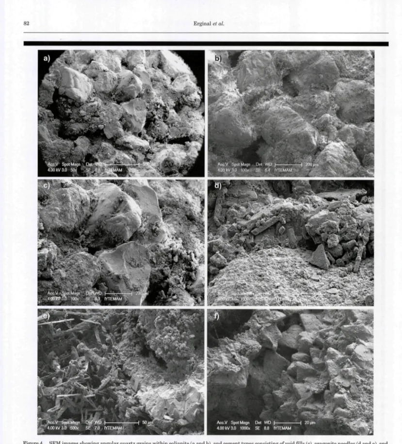
The eolianite is an orange-to-hrown sandstone, hased on its pétrographie classification (Pettijohn, Potter, and Siever, 1987). It consists predominantly of calcite, aragonite, and quartz, as defined by X-ray diffractometry, and constitutes a single sandstone block with maximum thickness of 7 m. The presence of various fragments of quartzite, schist, limestone, and volcanic rocks shows that the eolianite sands and lithoclasts were derived from neighboring lands. The rock includes so-called rhizoliths as organosedimentary structures, characterized by subvertical root tuhules and long bifurcated rhizoUths with accumulated carhon-ate fills (Figures 3c and d). With regard to the shape, roundness, sorting, and cementation degree of the eoHanite sands, SEM
analyses showed that the rock is made up of poorly rounded quartz grains with sizes ranging from 200 to 500 |.im (Figures 4a and h). Spar calcite and void fillings dominate (Figure 4c). Grain surfaces are encrusted with a mixture of calcite and aragonite that forms micrite coatings with a thickness up to 20 |im (Figure 4d). Meniscus and gravitational cements also occur on grain boundaries as second-generation precipitation on micrite envelops covering the grain surfaces. In addition, aragonite crystals with random distribution and reciprocal calcite rims exist (Figures 4e and f). A recent study on the dating of quartz-bearing eolianites yielded optical luminescence ages of hetween 24.21±1.53 and 16.18±1.70 ka, a time interval coinciding with oxygen isotope stage 2 (Kiyak and Erginal, 2010). Thus, reworking of shelf sediments rich in shallow-marine carbonates into coastal dune sands during the last glacial maximum (Sayles, 1931) can he suggested concerning supply of connective cement material to Bozcaada eolianites.
82 Erginal et al.
Figure 4. SEM images showing angular quartz grains within eolianite (a and b), and cement types consisting of void fills (c), aragonite needles (d and e), and reciprocal micrite rims (f).
Subsurface Characteristics
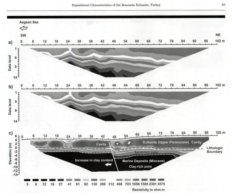
The ERT survey was performed on the south coast of Bozcaada Island. The observed and calculated apparent resistivity pseudosections are shown in Figures 5a and b, respectively. Figure 5c shows the inverse model resistivity
section with corrected topography. The SW-NE trending two-dimensional (2D) resistivity image displayed a depth range of —17 m and showed a strong resistivity contrast. The overall resistivity range in the image is ~5 to 3580 ohm m. The eoHanite unit was distinctly identified in the inverse model section as having very high resistivities in proportion to the
a) Aegean Sea <=! SW 0 6 12 Î 9 14
b)
14 18 24 30 36 42 48 54 60 72 78 84 NE 90 96 102 m 12 18 24 30 36 42 48 54 60 66 72 78 84 90 96 102 m C) (m ) o at i > (U UJ 2 - 0--2 -4 -6 -8 -10 -12 -14 66 72 78 . 84 , 90 96 102 mEolianite (Upper RIeistocene) Cavity
'- Lithologie Boundary
Increase in clay content ' Marine Deposits (Miocene) Clay-rich zone
5 8 12 18 27 41 61 92 138 208 312 468 703 10561585 23813575
Resistivity in ohm.m
Figure 5. 2D modeling of geoelectrical survey: measured apparent resistivity pseudosection (a), calculated apparent resistivity pseudosection (b), and inverse model resistivity section (c).
underlying Upper Miocene marine deposits, defined by low resistivities. One of the features of the resistivity image is the gradual decrease in resistivity values of the Miocene units seaward, caused by an increase in clay content. In addition, a relatively resistive zone in comparison to the clay-rich unit appears clearly toward the NE after a horizontal distance of 48 m. This part of the tomogram has a thickness of ~3 to 4 m and is located in the upper layer of marine deposits. This may be due to an increase in sand content.
The high-resistivity variation in the eolianite, in the range of —700 to 3580 ohm m, is likely associated with the presence of
variously sized weathered cavities. The eolianite with
weath-ered cavities of different sizes was found to have a thickness of ~4 to 7 m, with thickening taking place toward the end of the survey line (i.e., leeward). These results suggest that eolian windblown sand transport occurred on an approximately horizontal surface of the basement unit, marked by an abrupt
transition. The abnormal topography marked by a local subsidence between —47 and 52 m can be attributed to the collapse of eolianite blocks. This collapse is likely related to dislocation caused by a high-angle normal fault. In addition, the high-percolation capacity of the overlying eolianite, and therefore water-saturated condition of the clay-bearing surface of the underljdng unit, might have contributed to the collapse.
Paleowind Estimations Based on Bedding and Recent Wind Regime
From the coastal outcrops to the sea-facing steep cliffs formed of fossiliferous Miocene limestones, the sequence shows no variation in its stratigraphie system, which is dominated by a cross-bedding structure. A cross-bedded laminae structure is common, represented by seaward {i.e., SE) and leeward (i.e., NE) dipping steep (average 20°) foresets from bottom to top. A
84 Erginal et al.
d) wind speed (m/s)
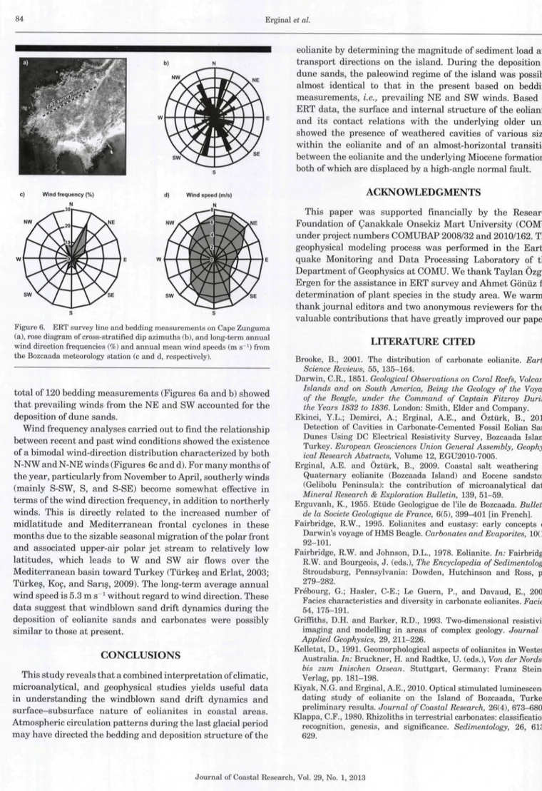
Figure 6. ERT survey line and bedding measurements on Cape Zunguma (a), rose diagram of cross-stratified dip azimuths (b), and long-term annual wind direction frequencies (%) and annual mean wind speeds (m s ') from the Bozcaada meteorology station (c and d, respectively).
total of 120 bedding measurements (Figures 6a and b) showed that prevailing winds from the NE and SW accounted for the deposition of dune sands.
Wind frequency analyses carried out to find the relationship between recent and past wind conditions showed the existence of a bimodal wind-direction distribution characterized by both N-NW and N-NE winds (Figures 6c and d). For many months of the year, particularly from November to April, southerly winds (mainly S-SW, S, and S-SE) become somewhat effective in terms of the wind direction frequency, in addition to northerly winds. This is directly related to the increased number of midlatitude and Mediterranean frontal cyclones in these months due to the sizable seasonal migration of the polar front and associated upper-air polar jet stream to relatively low latitudes, which leads to W and SW air flows over the Mediterranean basin toward Turkey (Türke? and Erlat, 2003; Turkey, Koç, and Sariç, 2009). The long-term average annual wind speed is 5.3 m s ' without regard to wind direction. These data suggest that windblown sand drift dynamics during the deposition of eolianite sands and carbonates were possibly similar to those at present.
CONCLUSIONS
This study reveals that a combined interpretation of climatic, microanal3^ical, and geophysical studies yields useful data in understanding the windblown sand drift dynamics and surface-subsurface nature of eolianites in coastal areas. Atmospheric circulation patterns during the last glacial period may have directed the bedding and deposition structure of the
eolianite by determining the magnitude of sediment load and transport directions on the island. During the deposition of dune sands, the paleowind regime of the island was possibly almost identical to that in the present based on bedding measurements, i.e., prevailing NE and SW winds. Based on ERT data, the surface and internal structure of the eolianite and its contact relations with the underlying older units showed the presence of weathered cavities of various sizes within the eolianite and of an almost-horizontal transition between the eolianite and the underlying Miocene formations, both of which are displaced by a high-angle normal fault.
ACKNOWLEDGMENTS
This paper was supported financially by the Research Foundation of Çanakkale Onsekiz Mart University (COMU) under project numbers COMUBAP 2008/32 and 2010/162. The geophysical modeling process was performed in the Earth-quake Monitoring and Data Processing Laboratory of the Department of Geophysics at COMU. We thank Taylan Özgür Ergen for the assistance in ERT survey and Ahmet Gönüz for determination of plant species in the study area. We warmly thank journal editors and two anonymous reviewers for their valuable contributions that have greatly improved our paper.
LITERATURE CITED
Brooke, B., 2001. The distrihution of carbonate eolianite.
Earth-Science Reviews, 55, 135-164.
Darwin, C.R., 1851. Geological Observations on Coral Reefs, Volcanic
Islands and on South America, Being the Geology of the Voyage of the Beagle, under the Command of Captain Fitzroy During the Years 1832 to 1836. London: Smith, Elder and Company.
Ekinci, Y.L.; Demirci, A.; Erginal, A.E., and Öztürk, B., 2010. Detection of Cavities in Carhonate-Cemented Fossil Eolian Sand Dunes Using DC Electrical Resistivity Survey, Bozcaada Island, Turkey. European Geosciences Union General Assembly,
Geophys-ical Research Abstracts, Volume 12, EGU2010-7005.
Erginal, A.E. and Öztürk, B., 2009. Coastal salt weathering of Quaternary eolianite (Bozcaada Island) and Eocene sandstone (Geliholu Peninsula): the contribution of microanalytical data.
Mineral Research & Exploration Bulletin, 139, 51-59.
Erguvanh, K., 1955. Etüde Geologigue de l'ile de Bozcaada. Bulletin
de la Société Géologique de France, 6(5), 399^01 [in French].
Fairhridge, R.W., 1995. Eolianites and eustasy: early concepts on Darwin's voyage of HMS Beagle. Carbonates and Evaporites, 10(1), 92-101.
Fairbridge, R.W. and Johnson, D.L., 1978. Eolianite. In: Fairbridge, R.W. and Bourgeois, J. (eds.). The Encyclopedia of Sedimentology. Stroudsburg, Pennsylvania: Dowden, Hutchinson and Ross, pp. 279-282.
Frébourg, G.; Hasler, C-E.; Le Guern, P., and Davaud, E., 2008. Faciès characteristics and diversity in carhonate eolianites. Fades, 54, 175-191.
Griffiths, D.H. and Barker, R.D., 1993. Two-dimensional resistivity imaging and modelling in areas of complex geology. Journal of
Applied Geophysics, 29, 211-226.
Kelletat, D., 1991. Geomorphological aspects of eolianites in Western Australia. In: Bruckner, H. and Radtke, U. (eds.). Von der Nordsee
bis zum Inischen Ozsean. Stuttgart, Germany: Franz Steiner
Verlag, pp. 181-198.
Kiyak, N.G. and Erginal, A.E., 2010. Optical stimulated luminescence dating study of eolianite on the Island of Bozcaada, Turkey: preliminary results. Journal of Coastal Research, 26(4), 673-680. Klappa, CF., 1980. Rhizoliths in terrestrial carbonates: classification,
recognition, genesis, and significance. Sedimentology, 26, 613-629.
Loke, M.H. and Barker, R.D., 1996. Rapid least-squares inversion of apparent resistivity pseudosections by a quasi-Newton method.
Geophysical Prospecting, 44, 131-152.
Loke, M.H.; Acworth, I., and Dahlin, T., 2003. A comparison of smooth and blocky inversion methods in 2D electrical resistivity imaging.
Exploration Geophysics, 34, 182-187.
Olayinka, A.I. and Yaramanci, U., 2000. Assessment of the reliability of 2D inversion of apparent resistivity data. Geophysical
Prospect-ing, 48(2), 293-316.
Pettijohn, F.J.; Potter, P.E., and Siever, R., 1987. Sand and
Sandstone. Berlin: Springer & Verlag, 553p.
Saltik, O. and Saka, K., 1972. Geological investigation of northern Saros Gulf, Gelibolu Peninsula, Imbroz-Bozcaada and Canakkale coastline. TPAO Archives, No. 786, 30 p.[in Turkish].
Sayles, R.W., 1931. Bermuda during the ice age. Proceedings of the
American Academy of Arts and Science, 66, 381-467.
Schlichting, E. and Blume, H.P., 1966. Bodenkundliches Praktikum. Hamburg, Germany: Verlag Paul Paney [in German].
Thomas, D.S.G., 1997. Sand seas and aeolian bedforms. In: Thomas, D.S.G. (ed.). Arid Zone Geomorphology: Process, Form and Change
in Drylands, 3rd edition, Chichester, United Kingdom: John Wiley
& Sons, pp. 373-412.
Thornthwaite, C.W., 1948. An approach toward a rational classifica-tion of climate. Geography Review, 38, 55—94.
Türke?, M., 1998. Influence of geopotential heights, cyclone frequency and Southern Oscillation on rainfall variations in Turkey.
Inter-national Journal of Climatology, 18, 649-680.
Turkey, M., 1999. Vulnerability of Turkey to desertification with respect to precipitation and aridity conditions. Turkish Journal of
Engineering and Environmental Science, 23, 363—380.
Türke?, M. and Erlat, E., 2003. Precipitation changes and variability in Turkey linked to the North Atlantic Oscillation during the period 1930-2000. International Journal of Climatology, 23, 1771-1796. Türke?, M.; Koç, T., and Sariç, F., 2009. Spatiotemporal variability of precipitation total series over Turkey. International Journal of
Climatology, 29, 1056-1074.
Woodrofl'e, CD.; Murray-Wallace, C.V.; Bryant, E.A.; Brooke, B.P.; Price, D.M., and Heijnis, H., 1995. Late Quaternary sea-level highstands from the Tasman Sea: evidence from Lord Howe Island.