DESIGN AND IMPLEMENTATION OF AN OPEN ACCESS GEOPORTAL
1Fatih SARI
1Selçuk Üniversitesi, Çumra Uygulamalı Bilimler Yüksekokulu, Yönetim Bilişim Sistemleri Bölümü 1[email protected]
(Geliş/Received:08.01.2017 ; Kabul/Accepted in Revised Form: 29.07.2017 )
ABSTRACT: GeoPortal Systems are being considered one of the most important object in interoperability concept for Spatial data Management. With the developing technology of the information age, the need for accessing to spatial data is caused to effort for establishing national, regional and local information systems by institutes and organizations. Sharing and accessing of spatial datasets between institutes and organizations are being more important within interoperability concept. In this study, Open Access GeoPortal System is designed and applied to establish a common platform for institutes/organizations to analyze, interact, view, query and share spatial data. Open Access GeoPortal System, which is aimed to develop effective solutions in the field of using and sharing spatial data and establish interoperability concept, intends to provide an infrastructure for users to realize functions related with spatial data on web without installing any software. Open Access GeoPortal System is providing standardization stage acceleration, interoperability concept establishment and solutions to problems of spatial data thanks to the developed functions and processes which are working on international standardization organizations as like INSPIRE, ISO, W3C and OGC.
Key Words: GeoPortal, Interoperability, Open Source Software Development, Web GIS, Web Services.
Açık GeoPortal Sistemi Tasarımı ve Uygulaması
ÖZ: GeoPortal sistemleri, Konumsal Veri Altyapıları için birlikte çalışabilirlik kavramını sağlayan en önemli yapılardan birisidir. Teknolojik gelişmeler, kurumların ve organizasyonların bilgiye erişme ihtiyacı, yerel, bölgesel ve ulusal ölçekte bilgi sistemlerinin oluşturulmasına neden olmaktadır. Birlikte çalışılabilirlik kavramı içerisinde kurumlar ve organizasyonlar arasındaki bilgi paylaşımı daha da önemli hale gelmiştir.
Bu çalışmada, kurumlar/organizasyonlar arasında konumsal verinin paylaşımı, analizi, görüntülenmesi ve depolanması için Açık GeoPortal sisteminin tesis edilmesi ve geliştirilmesi gerçekleştirilmiştir. Açık GeoPortal Sistemi, herhangi bir yazılım kurmadan konumsal verinin paylaşımına ve erişimine etkin çözüm getirmek amacı ile birlikte çalışabilirlik kavramı kurmak için oluşturulmuştur. Açık GeoPortal Sistemi, standartlaşma çalışmalarının hızlanmasına, konumsal verinin paylaşımında yaşanan sorunlara çözün getirmek amacı ile INSPIRE, ISO, W3C ve OGC organizasyonlarının standartları kullanılarak oluşturulmuştur.
Anahtar Kelimeler: GeoPortal, Birlikte çalışıabilirlik, Açık kaynak kodlu yaızlım geliştirme, Web CBS, Web servisleri,
INTRODUCTION
Access to spatial data, observations, and analytical results from diverse sources facilitates interdisciplinary and exploratory research, analysis, and decision-making, particularly in the case of geospatial information (Evans and Bambacus, 2005). Since the late 1990s, the geographic industry has
seen increasing interest and activity in the deployment of web sites that provide access to geographic content (Tait, 2005). This is achieved with the development of World Wide Web (WWW) and Geographical Information Systems (GIS) corporation. Geographic portals represent an applied response to this need to disseminate geographic data and leverage the GIS community’s substantial investment in GIS capabilities and content (NRC, 1999).
Access, distribution and share of geographic information are the core object of each Spatial Data Infrastructure (SDI) project (Tang and Selwood, 2005). Spatial Data Infrastructure (SDI) are interoperability component for spatial data management and SDI’s are the main object to establish interoperability at national, regional and local scales (Cömert, 2004). In (GSDI, 1999) definition, it is clearly defined that one of the main aim of SDI is to “provide instant access to geographic information. The United States National Research Council’s Mapping Sciences Committee that first coined the term “spatial data infrastructure” in 1993, defined SDI as “the means to assemble geographic information that describes the arrangement and attributes of features and phenomena on the earth. In more explanatory definition, SDI is a combination of attribute and spatial data, which are coming from distributed databases and data sources, together with technologies, tools and technical structure to provide access to spatial data by users (Masser, 2005). The mentioned tools and technical structures are being GeoPortal systems.
There are many different GeoPortal definitions are available in literature and highlights “accessing spatial data via web” expression. (BEA, 2008) is defined GeoPortal as “a web site which is only one way to access spatial data and its applications”. Java Portlet is defined GeoPortal as “personal or common web applications which are combining spatial data from different sources or data providers” (Abdelnur and Hepper, 2003). According to the (ESRI, 2013), GeoPortal is “a system to access spatial data without depending to location, format and data types”. Open Geospatial Consortium (OGC) defines GeoPortal as a “human interface to collect online spatial data sources, spatial datasets and services together” (OGC, 2004). (Tang and Selwood, 2005) are defined GeoPortal as a gateway to the SDI systems. Thanks to the developments of web services, SDI implementation is being successful for accessing and sharing data. Because of GeoPortal systems constitute a connection bridge between data producers and users via web services, developing intelligent GeoPortal systems will be visible interface of SDI systems and it is being possible to accomplish the requirements of SDI systems (Iwaniak et al., 2011). Web services are providing advanced information technologies for comprehensive GIS functions to establish interoperability (You et al., 2012). Web services are developing a standardized internet based communication bridge between different institutes and information systems (Alonso et al., 2004), (Zhang and Li, 2005). Thanks to increasing importance and developments of SDI’s, accessing to spatial data with web services is raised in last decade (Florczyk et al., 2012).
GeoPortals act as information aggregators providing a single access point to a variety of information sources. Therefore, they have an important role to play as entry points for the discovery, visualization and retrieval of data and services that constitute the geospatial web. This can be called as distributed computing and GeoPortals are the main structure of this concept. Distributed computing has provided the foundational standards and technology on which the Internet and distributed GIS are built. The core object of the distributed GIS and interoperability structures are the internet technology. The internet consists of technology standards, such as, Transmission Control Protocol/Internet Protocol (TCP/IP) and Hyper Text Transport Protocol (HTTP). The internet protocols specify the data transfer between server and client computers as well as software and network infrastructure. Because of GeoPortal systems are providing interoperability, some standards and definitions must be considered for GeoPortal development. U.S. Federal Geographic Data Committee (FGDC), The Open Geospatial Consortium, The International Organization for Standardization (ISO) / Technical Committee 211 (TC211), Open Geospatial Consortium (OGC) and INSPIRE committees are developing standards to establish interoperability platform within GeoPortal concept (Yang et al., 2006; Rautenbach et al., 2013).
In GeoPortal literature, existing GeoPortal systems and their infrastructure are being presented in most of the studies. Earth Science Gateway (ESG) GeoPortal (Bambacus et al., 2007), Knowledge
Annotation Initiative of the Knowledge Acquisition Community (KA2) GeoPortal (Benjamins et al., 1999), Germany Subsurface GeoPortal (DINO) (Lance et al., 2011), The developed GeoPortals around United Kingdom (Beaumont et al., 2005), Multi Agency Geographic Information for the Countryside, (MAGIC) GeoPortal (Askew et al., 2005), Disaster Risk Management Portal (NDRMP) GeoPortal, (Samadzadegan et al., 2008), Europan GeoPortal and Europan Spatial Data Infrastructure (ESDI) (Bernard et al., 2005) and INSPIRE GeoPortal (Crompvoets et al., 2004) are examined. Another important field of GeoPortal systems literature are SDI systems. An intelligent GeoPortal system design to provide spatial data to planners is developed by (Iwaniak et al., 2011), the reasons to develop GeoPortals and the importance for SDI projects are presented by (Maguire and Longley, 2005), the benefits of well-designed GeoPortals and the gaining in SDI Systems are detailed by (Tang and Selwood, 2005) and technologies, infrastructures and development stages for SDI Based GeoPortals are detailed by (Yang et al., 2006). Common GeoPortal development systems, technologies and system designs are also being presented in literature. The benefits of Web 2.0 technologies in GeoPortal systems (Bertrand, 2010), The Geospatial Portal Reference Architecture (Liu et al., 2008), A semantic spatial data search tool for E-Government GeoPortal (Wiegand, 2007), GeoPortal development technologies (Tait, 2005), The thematic map production via web services and (Rautenbach et al., 2013), Spatial data integration to GeoPortal (Yang et al., 2007), Resource Description Framework (RDF) tool to search spatial data in GeoPortal (Athanasis et al., 2009) and existing GeoPortals and developing their search and mapping technologies (Frehner and Brandli, 2006).
OPEN ACCESS GEOPORTAL DESIGN
The main aim of the Open Access Geoportal (OAG) is to establish a platform which is providing tools to access, distribute, share and represent of spatial data through web based GeoPortal interfaces without using any GIS software with developed additional services and interfaces. Within OAG, additional spatial data functions, existing GeoPortal technologies, international standard specifications, developable function for existing GeoPortal interfaces are examined to improve the capability of OAG according to the requirements for spatial data users-providers and additional services are developed.
If have a look to the existing GeoPortals as like Group on Earth Observations (GEO), Ontario Council of University Scholars GeoPortal, National Oceanic and Atmospheric Administration (NOAA), National Geophysical Data Center (NGDC), United Nations World Food Programme SDI-T (WFP), United Nations Environment Programme (UNEP) GeoPortal, Spain IDECLM and HlanData GeoPortals, it seems that, commonly GeoPortal systems are providing view service of spatial data. Although GeoPortal systems are providing legend information of spatial data, styling spatial data or generating symbology with Styled Layer Descriptor (SLD) is being impossible due to the lack of symbology tools.
OAG is developed based on five main services addition to MC GeoPortal interface. Heron-MC JavaScript Library provides a user interface for the GeoPortal and WebGIS applications. Heron-Heron-MC supports a flexible and open source development environment for users and developers. Adding new functions and integrate new services into the client is possible and easy with its flexible structure with JavaScript and HTML programming languages. Additionally, Php programming language can be used for server-side operations scripting. Heron-MC interface is suitable for use as a GeoPortal interface due to the functions of view, query, display attribute data and other tools. The OAG structure is shown in Figure 1.
Figure 1. OAG structure
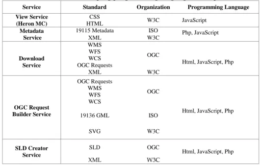
The OAG is being a technical platform between institutes and organizations which are using or producing spatial data together with the implementation of international standards as like OGC, INSPIRE, W3C and ISO. Within OAG, OGC standards are used to develop web services and related functions for spatial data with WMS, WFS and WCS. INSPIRE data specifications are used to define spatial data catalogues and their specifications with Annex-I and Annex-II-III catalogues. W3C standards are used to implement web interfaces and internet protocols for OAG. ISO standards are used to develop metadata service (ISO 19115) within 19100 Geographic Information Standard series. The OAG components, standards, organizations and programming languages according to the developed services are given in Table 1.
Table 1. OAG developing programming languages and open standards Service Standard Organization Programming Language View Service (Heron MC) CSS HTML W3C JavaScript Metadata Service
19115 Metadata ISO Php, JavaScript
XML W3C Download Service WMS WFS WCS OGC Requests OGC Html, JavaScript, Php XML W3C OGC Request Builder Service OGC Requests WMS WFS WCS OGC Html, JavaScript, Php 19136 GML ISO SVG W3C SLD Creator Service SLD OGC Html, JavaScript, Php XML W3C View Service Metadata Service View Service OGC Request
Builder Service SLD Creator
Service
OPEN ACCESS GEOPORTAL
Interfaces Download Service OGC Requests GetMap GetCapabilities GetLegendGraph ic WMS WFS WCS Metadata Database Point SLD Line SLD Polygon SLD Raster SLD WMS Output Formats WFS Output Formats
Web Services Styled Layer
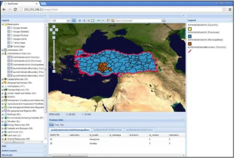
One of the main object of GeoPortal system is the view service. View service is providing to display the web services on a map object. Therefore, instead of searching spatial data through a keyword as like in catalogue GeoPortals, it is being more useful to display web services and interact with them. View service is being GeoPortal interface which include tools and functions to interact with web services. The best way to interact with web services and use all the functions is to utilize the Heron Mapping Client (MC) JavaScript library. The OAG web interface home page and related function replacements are given in Figure 2.
Figure 2. OAG home page
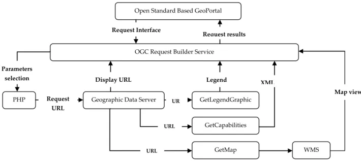
OGC Request Builder Service
OGC Request Builder Service is developed to provide a user-interface to constitute request for retrieving data according to the user-defined parameters. Commonly in GeoPortal systems, web services are integrated with the default configuration in the fields of symbology, coordinate system and data format which is specified by spatial data authorities. OGC Request Builder Service is developed to provide download option of spatial data according to the user defined parameters within OAG. OGC Request Builder Service web forms for each request are given in Figure 3.
Figure 3. OGC Request Builder Service web forms
OGC Request Builder Service is based on PHP codes which are generating URL for requests according to the user defined parameters via web forms (Figure 3). The parameters are specifying the variables of request and defined in web forms according to the mandatory and optional parameters which is specified in OGC catalogues. The flowchart of the OGC Request Builder Service is given in Figure 4.
Figure 4. OGC Request Builder Service flowchart
Download Service
Download Service is developed to enable download operation spatial data through web services. Spatial data users are usually needs to get data from GeoPortal systems. Because of there are a large amount of spatial data format, software and spatial analysis functions are being used, spatial data should be download It is based on GetMap requests and including WMS, WFS and WCS supported output file formats. The structure is similar with the OGC Request Builder Service in the field of web service URL generating. The only difference is in Download Service, users are not specifying any
Geographic Data Server
Open Standard Based GeoPortal
OGC Request Builder Service
PHP WMS GetLegendGraphic GetMap GetCapabilities Request Interface Parameters selection Request URL Display URL URL URL UR L Legend Image XML
Document Map view
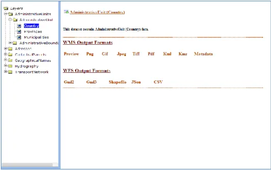
parameters to download data. Instead of this, by clicking to the desired file format, download option will be started. Download service interface is developed with Php codes including web service and data format selection. The Download Service web interface is given in Figure 5.
Figure 5. Download Service web interface
When users select data format, GetMap request is constituted with PHP codes and send to server for retrieve data in specified format. The Geographical data server will be processed the request and prepare the file format according to the GetMap request parameters. Download Service structure is given in Figure 6.
Figure 6. Download Service structure
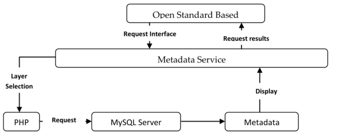
Metadata Service
Metadata service is developed to provide view of metadata for web services via web interface. Because of metadata is including the descriptive information about web services, developed GeoPortal systems should include metadata services to increase the usability of web services in the terms of
UR L
Open Standard Based GeoPortal
Download Service
PHP Geographic Data Server
GetMap Request Request Interface Parameters selection Request URL Display URL Request results WCS WFS WMS Tiff, Jpeg Bmp, Png ShapeFile Gml2, Gml3 Json, Csv Kml, Kmz
interoperability. Metadata service is consisted from a MySQL database to store metadata files and HTML page to display related metadata. The metadata service is based on Php codes which are connect and retrieve metadata information from MySQL database and display on web pages. Metadata Service structure is given in Figure 7.
Figure 7. Metadata Service structure
The web page of the metadata service is given in Figure 8 for INSPIRE Administrative Unit thematic scheme.
Figure 8. Metadata Service web page Open Standard Based
GeoPortal
Metadata Service
PHP MySQL Server Metadata
Request Interface Layer Selection Request Display Metadata Request results
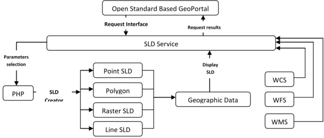
SLD Creator Service
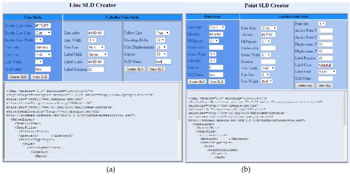
Web service symbology and related SLD files usually are being specified by spatial data authorities, thus, it is being impossible to define or create SLD files within GeoPortal systems On the other hand, existing GeoPortal Systems are not including SLD creating function and users are unable to view, edit or change the SLD file within GeoPortal interfaces. Therefore, SLD files which are created by desktop GIS systems are couldn’t be used in GeoPortal systems. SLD Creator Service is consist from user forms to select variables for each parameter of SLD files which are given in Figure 9.
(a) (b)
(c) (d)
Figure 9. SLD Service Web forms a) Line SLD b)Point SLD c) Polygon SLD d) Raster SLD
SLD is XML based files and define the variables between tags and can define point, polyline, polygon, raster files and their label options. Symbol styles, colors, sizes, placements, label fields, label
styles and related parameters can be defined with SLD files according to the point, polyline, polygon and raster data types. When users specified the parameters, PHP codes are generated the SLD files with inserting each variable into related tags. SLD Creator Service structure is given in Figure 10.
Figure 10. SLD Service structure
RESULT AND DISCUSSION
OAG presenting a gateway to the distributed GIS due to the interoperability components and representing a reference GeoPortal application. One of the main obstacles of establishing GeoPortal is the status of spatial data. The solution of spatial data quality depends to INSPIRE and ISO standards to be understood by data providers. Before constituting GeoPortal systems, INSPIRE and ISO standards must be applied to spatial datasets. Addition to this, generating incomplete attribute data and metadata is required together with spatial data. This situation is also provide accurate and up-to-dated spatial data infrastructure and will contribute to OAG establishing concept. Reliable and up-to-dated spatial data will increase decision-making quality and decision support system applications. Standardization policies and applications should be started in every institute and then at national scales, spatial data should be integrated into NSDI.
Discussion
OAG implementation can be useful in environmental monitoring such as meteorological monitoring, air quality, geological changes, agriculture management, water resources and urban settlements. OAG can be modified according to the requirements and aims of the projects. Thus, it is being possible to interact with spatial data and increase the usability of spatial data.
One of the main obstacles of establishing GeoPortal in Turkey is the status of spatial data. The solution of spatial data quality depends to INSPIRE and ISO standards to be understood by data providers. Before constituting GeoPortal systems, INSPIRE and ISO standards must be applied to spatial datasets. Addition to this, generating incomplete attribute data and metadata is required together with spatial data. This situation is also provide accurate and up-to-dated NSDI spatial data infrastructure and will contribute to Turkey National GIS (TNGIS) establishing concept. Reliable and up-to-dated spatial data will increase decision-making quality and decision support system applications. Standardization policies and applications should be started in every institute and then at national scales, spatial data should be integrated into NSDI.
WFS WMS WCS Geographic Data Server SLD Creator Point SLD SLD Service PHP Request Interface Parameters selection Request results
Open Standard Based GeoPortal
Polygon SLD Raster SLD Line SLD Display SLD
Because of GeoPortal systems are the main component of interoperability concept, as mentioned in TNGIS policies, Turkey should establish national GeoPortal system to provide accessibility of spatial data for every institute and data users. GeoPortal systems will contribute to interoperability concept in Turkey both accessibility to spatial data and the quality requirements of each spatial datasets all around Turkey.
REFERENCES
Abdelnur, A., Hepper, S., 2003, Java Portlet Specification, Version 1.0, Status: FCS Specification, Specification Lead: Sun Microsystems, Inc., Release: August 29.
Alonso, G., Casati, F., Kuno, H., Machiraju, V., 2004, Web Services. Concepts, Architectures and Applications, Springer, Berlin/Heidelberg.
Askew,D., Evans,S., Matthews, R., Swanton, P., 2005, “MAGIC: a Geoportal for the English Countryside”, Computers, Environment and Urban Systems, Vol. 29, pp. 71–85.
Athanasis, N., Kalabokidis, K., Vaitis, M., Soulakellis, N., 2009, “Towards a Semantics-Based Approach in the Development of Geographic Portals”, Computers & Geosciences, Vol. 35, pp. 301– 308. Bambacus, M., Yang, C., Evans,J., Cole, M., Alameh, N., Marley, S., 2007, “An Interoperable Portal
Supporting Prototyping Geospatial Applications”, URISA Journal, Vol. 19(2), pp.15-21. BEA, 2008, BEA WebLogic Portal, Portal Development Guide, BEA Systems, Inc.
Beaumont, P., Longley, P.A., Maguire, D.J., 2005, “Geographic Information Portals - a UK Perspective”, Computers, Environment and Urban Systems, Vol. 29, pp. 49–69.
Benjamins, R. Fensel, D., Decker, S., 1999, “KA2: Building Ontologies for the Internet: A Midterm Report”, International Journal of Human Computer Studies, Vol. 51(3), pp. 687.
Bernard, L., Kanellopoulos, I., Annoni,A., Smits, P., 2005, “The European Geoportal––One Step Towards the Establishment of a European Spatial Data Infrastructure”, Computers, Environment and Urban Systems, Vol. 29, pp. 15–31.
Bertrand De Longueville, 2010, “Community-Based Geoportals: The Next Generation? Concepts and Methods for The Geospatial Web 2.0.” Computers, Environment and Urban Systems, Vol. 34,pp. 299–308.
Cömert, Ç., 2004, “Web Services and National Spatial Data Infrastructures”, International Society of Photogrammetry and Remote Sensing, XXth Congress, Commission IV, WG IV/4, Spatial Data Infrastructure, Istanbul, Turkey, 12-23 July 2004.
Crompvoets, J., Wachowicz, M., Bree, F., Bregt, A., 2004, “Impact Assessment of The Inspire Geo-Portal”, 10th EC GI & GIS Workshop, ESDI State of the Art, Warsaw, Poland, 20-25 June 2004.
ESRI, 2013, GIS Portal Technology, ESRI White Paper,
http://www.esri.com/library/whitepapers/pdfs/geospatial-portal-technology.pdf, (10.10.2016). Evans, J.D., Bambacus, M.J., 2005, “NASA's Earth-Sun System Gateway: an Open Standards-Based Portal
to Geospatial Data and Services”, Geoscience and Remote Sensing Symposium, IGARSS '05, Proceedings 2005 IEEE International, Seoul, Korea, 25-29 July 2005.
Florczyk, A.J., Nogueras, J., Zarazaga-Soria, F.J., Be´ jar, R., 2012, “Identifying Ortho images in Web Map Services”, Computers & Geosciences, Vol. 47, pp. 130–142.
Frehner, M., Brandli, M., 2006, “Virtual Database: Spatial Analysis in a Web-based Data Management System for Distributed Ecological Data”, Environmental Modelling & Software, Vol. 21, pp. 1544-1554.
GSDI, 1999, The Strategic Imperative of a Global Spatial Data Infrastructure, http://www.gsdidocs.org/docs1999/stratim.html, (07.10.2016).
Iwaniak, A., Kaczmarek, I., Kubik, T., Łukowicz. J., Paluszynski, W., Kourie. D., Cooper. A., Coetzee. S., 2011, “An Intelligent Geoportal For Spatial Planning, Intelligent geoportal for spatial planning”, 25th International Cartographic Conference (ICC 2011), Paris, France, 3-8 Jul 2011.
Lance, K.T., Georgiadou, Y.P., Bregt, A.K., 2011, “Evaluation of the Dutch Subsurface Geoportal: What Lies Beneath?”, Computers, Environment and Urban Systems, Vol. 35, pp. 150–158.
Liu, L., Li, D., Shao, Z., 2008, “Design and Implementation of a Geospatial Portal”, Geoinformatics 2008 and Joint Conference on GIS and Built Environment: Geo-Simulation and Virtual GIS Environments. Maguire, D.J., Longley,P.A., 2005, “The Emergence of Geoportals and Their Role in Spatial Data
Infrastructures”, Computers, Environment and Urban Systems, Vol. 29, pp. 3–14. Masser, I. 2005, GIS Worlds: Creating Spatial Data Infrastructures, Redlands: ESRI Press.
National Research Council, 1999, Distributed Geo libraries: Spatial Information Resources, National Academy Press: Washington, DC.
OGC, 2004. Geospatial Portal Reference Architecture, A Community Guide to Implementing Standards-Based Geospatial Portals, Version: 0.2, OGC 04-039, OGC Discussion Paper.
Rautenbach,V., Coetzee,S., Iwaniak.A., 2013, “Orchestrating OGC Web Services to Produce Thematic Maps in a Spatial Information Infrastructure”, Computers, Environment and Urban Systems, Vol. 37, pp. 107–120.
Samadzadegan, F., Saeedi, S., Alvand, A., 2008, “Design and Implementation of a Service Oriented Geospatial Portal for Disaster Risk Management”, Tenth International Conference for Spatial Data Infrastructure, St. Augustine, Trinidad, 25-29 February 2008.
Tait, M.G., 2005, “Implementing Geoportals: Applications of Distributed GIS”, Computers, Environment and Urban Systems, Vol. 29, pp. 33–47.
Tang, W., Selwood, J., 2005, “Spatial Portals: Adding Value To Spatial Data Infrastructures”, ISPRS Workshop on Service and Application of Spatial Data Infrastructure, XXXVI(4/W6), Hangzhou, China, 14- 16 October 2005.
Wiegand, N., 2007, “Semantic Web for Geospatial E-Government Portal”, The Proceedings of the 8th Annual International Digital Government Research Conference, Philadelphia, 20-23 May 2007. Yang, P.C., Cao,Y., Evans,J., Kafatos,M., Bambacus,M., 2006, “Spatial Web Portal for Building Spatial
Data Infrastructure”, Journal of The International Association of Chinese Professionals in Geographic Information Sciences, Vol. 6, pp. 38-43.
Yang, C., Evans,J., Cole, M., Alameh, N., Marley, S., Bambacus, M., 2007, “The Emerging Concepts and Applications of the Spatial Web Portal” , PE&RS, Vol. 73(6), pp. 691-698.
You, L., Gui, Z., Guo, W., Shen, S., Wu, H., 2012, “A Geospatial Web Services Composition Framework Supporting Real-Time Status Monitoring”, ISPRS Annals of the Photogrammetry, Remote Sensing and Spatial Information Sciences, Volume I-4, 2012 XXII ISPRS Congress, Melbourne, Australia, 25 August – 01 September 2012.
Zhang, C., Li, W., 2005, “The Roles of Web Feature and Web Map Services in Real-time Geospatial Data Sharing for Time critical Applications”, Cartography and Geographic Information Science, Vol. 32 (4), pp. 269-283.