CHANGES IN THE SOCIO-ECONOMIC STRUCTURE OF AN EXISTING NEIGHBORHOOD AFTER THE URBAN REGENERATION PROJECT:
THE CASE OF DIKMEN VALLEY
A THESIS SUBMITTED TO
THE DEPARTMENT OF INTERIOR ARCHITECTURE AND ENVIRONMENTAL DESIGN AND THE INSTITUTE OF
ECONOMICS AND SOCIAL SCIENCES OF BiLKENT UNIVERSITY
IN PARTIAL FULFILLMENT OF THE REQUIREMENTS FOR THE DEGREE OF
MASTER OF FINE ARTS
? » \ « Z Û î r c - L i ı i
By
Filiz Korkmaz Direkçi August, 1998
H T
Ίν г
•
Ί гI certify that I have read this thesis and that in my opinion it is fully adequate, in scope and in quality, as a thesis for the degree of Master of Fine Arts.
I certify that I have read this thesis and that in my opinion it is fully adequate, in scope and in quality, as a thesis for the degree of Master of Fine Arts.
A
Assist 4^rof Dr. Halijne Demirkan
I certify that I have read this thesis and that in my opinion it is fully adequate, in scope and in quality, as a thesis for the degree of Master of Fine Arts.
Approved by the Institute of Fine Arts
ABSTRACT
CHANGES IN THE SOCIO-ECONOMIC STRUCTURE OF AN EXISTING NEIGHBORHOOD AFTER THE URBAN REGENERATION PROJECT;
THE CASE OF DİKMEN VALLEY
Filiz Korkmaz Direkçi
M.F. A. in Interior Architecture and Environmental Design Supervisor; Assist. Prof. Dr. Zuhal Ulusoy
August, 1998
In this thesis, the aim is to evaluate the impact of an urban regeneration project on the socio-economic structure of an existing neighborhood based on the hypothesis that urban regeneration generally results in a change in the socio-economic structure of the regenerated neighborhood. Dikmen Valley which is one of the most important urban regeneration projects implemented in a squatter settlement has been chosen as the case. The focus of this study is the socio-economic status of people presently living in the houses constructed for the rightowners during the first phase of the project. Furthermore, variances between people that reside in Dikmen Valley are analyzed in order to affirm the existence of different socio-economic groups in contradiction with the initial of the project. The research question of the nature o f the changes are based on the socio-economic profile of the people who preferred to stay and who chose to move in the Valley after the project is completed. The differences between the socio economic groups are measured in terms of the decision of choosing to stay or move in to the Valley, social networks, interactions in and with the open spaces, the use and evaluation of the environment, and prospects about staying in the Valley or moving out. As a result of this study, it is found that currently two distinct socio-economic groups live in the same environment, as opposed to the homogenous social structure of the Valley prior to the project.
Keywords: Urban Regeneration, Socio-economic Structure, Squatter Settlements 111
ÖZET
KENTSEL YENİLEME PROJESİ SONRASI MEVCUT BİR MAHALLENİN SOSYO-EKONOMİK YAPISINDAKİ DEĞİŞİMLER:
DİKMEN VADİSİ ÖRNEĞİ
Filiz Korkmaz Direkçi
İç Mimarlık ve Çevre Tasarımı Bölümü Yüksek Lisans
Tez Yöneticisi; Y. Doç. Dr. Zuhal Ulusoy Ağustos 1998
Bu tezde, kentsel yenilemenin yenilenmiş mahalledeki sosyo-ekonomik yapıda
değişmeler ile sonuçlandığı hipotezine dayanarak, kentsel yenileme projesinin mevcut bir mahallenin sosyo-ekonomik yapısına olan etkisinin değerlendirilmesi
amaçlanmıştır. Gecekondu yerleşimlerine uygulanan kentsel yenileme projelerin en önemlilerinden biri olan Dikmen Vadisi çalışma alanı olarak seçilmiştir. Bu çalışmanın odak noktası, projenin birinci etabı sırasında haksahiplerine inşaa edilen konutlarda yaşayan insanlann sosyo-ekonomik statüleridir. Aynca, proje hedefleri ile çelişen çeşitli sosyo-ekonomik gruplarının varlığını doğrulamak için Dikmen Vadisinde oturan insanlar arasındaki farklılıklar analiz edilmiştir. Araştırma sorusunda yer alan
değişimlerin oluşum şekli, proje tamamlandıktan sonra mahallede yaşamaya devam eden ve mahalleye yeni taşınan insanlann sosyo-ekonomik profilerine dayandınlarak araştınlmıştır. Sosyo-ekonomik gruplar arasındaki farlılıklar, vadide kalmak veya vadiye taşınmak kararlan, sosyal ilişkiler, açık alanlar ile olan etkileşimler, çevre kullanımı ve değerlendirilmesi, ve vadide yaşayanlann kalmak ya da taşınmak ile ilgili planlan açısından ölçülmüştür. Bu çalışmanın sonucunda, vadinin önceki homojen sosyal yapısının aksine, şu anda, aynı çevrede iki ayn sosyal grubun yaşadığı bulunmuştur.
Anahtar Kelimeler; Kentsel Yenileme, Sosyo-ekonomik Yapı, Gecekondu
Yerleşimleri
Foremost, I would like to thank Assist. Prof. Dr. Zuhal Ulusoy for her invaluable help, support, tutorship, and friendship, without which this thesis would have been a much weaker one. Helpful comments of my jury members. Assist. Prof Dr. Halime
Demirkan and Assist. Prof Dr. Feyzan Erkip are also appreciated.
Secondly, I would like to thank Mr. Kenan Özdemir and Mr. Kunt Kuntasal for their continual support in data gathering and involvement of the case study.
I would like to extend my best regards to Mr. Oktay Deryaoğlu for his guidance in statistical analysis and many hours he spent in front of the computer with me.
Moreover, I am thankful to Mr. Kerem Ateş, Ms. Nilgün Camgöz and Ms. Nalan Şamil for their intellectual and logistic support.
A C K N O W L E D G E M E N T S
Last, but not least, I would like to thank my husband, Mr. Cemil Direk^i, for his patience and support during the preparation of this thesis.
T A B L E O F C O N T E N T S
1. INTRODUCTION
2. URBAN REGENERATION
1 6
2 .1. Brief History of Urban Regeneration... 6
2.2. Main Approaches to Urban Regeneration... 8
2.2.1. Redevelopment... 9
2.2.2. Rehabilitation...10
2.2.3. Urban Renewal... 11
2.2.4. Revitalization...12
2.2.5. Gentrification...13
2.3. Social Issues in Urban Regeneration... 16
2.3.1. Displacement...17
2.3.2. Participation in the Urban Process...19
3. URBAN REGENERATION IN ANKARA 22 3.1. The Turkish Context of Squatter Settlements...23
3.2. Current Urban Regeneration Efforts in Ankara... 28
3.2.1. Portakal Çiçeği Valley Urban Development Project... 32
3.2.2. Öveçler Valley... 37
3.2.3. imrahor Valley... 41
3.2.4. Hacibayram Environmental Development Project...47
3 .2.5. Discussion of the Urban Regeneration Efforts in Ankara...51
4. d i k m e n VALLEY HOUSING AND ENVIRONMENTAL DEVELOPMENT PROJECT 54 4.1. Project Site... 55
4.2. Objectives of the Project... 58
4.3. Basic Principles of the Project... 61
4.3.1. Housing...63
4.3.2. Municipality Service Areas... 65
4.3.3. Culturepark... 66
4.3.4. Culture Bridge... 67
4.4. Evaluation of the Project... 68
4.5. User Participation and Negotiations in Dikmen Valley...72
4.6. Research... 76
4.6.1. Methodology... 76
4.6.1.1. Formulation of the Research Question... 77
4.6.1.2. Variables... 78
4.6.2. Findings...81
4.6.2.1. Demographic Structure of the Population... 81
4.6.2.2. Habitat Selection in Terms of Environmental Preferences... 84
4.6.2.3. Evaluation and Use of the Environment... 90
4.6.2.4. Projections for the Future in Terms of Staying or Moving out... 106
3.3.3. Discussion of Findings... 109 5. CONCLUSION REFERENCES U 4 122 APPENDICES Appendix A- Questionnaire Sheet...127
Appendix B- Key of the Questionnaire... 137
L IST O F TA B L E S
Tables Page
3.1 “Gecekondu”s in Ankara... 29
4.1 SES indicators of families... 82
4.2 SES indicators to describe the interviewees... 84
4.3 Time lived in Ankara and Dikmen Valley... 85
4.4 Identification of the neighborhood...85
4.5 Previous neighborhood... 86
4.6 Reasons for moving out from previous neighborhood... 87
4.7 Reasons for prefering to live in Dikmen Valley... 88
4.8 Owning a flat in Ankara or another city and related preferences... 90
4.9 Changes made and wished to make about home... 91
4.10 Satisfaction with the dwelling and the physical environment...92
4.11 Where the inhabitants obtain their daily needs... 93
4.12 Social interaction among the inhabitants... 95
4 .13 The use of the previous garden and the current use of Culturepark...98
4.14 Complaints about outdoor spaces...99
4.15 Inhabitants’ opinions about Culture Bridge... 101
4.16 Opinions of the inhabitants about the new constructions going on
in the Municipality Service Areas...102
4.17 Opinions of the inhabitants about the other phases of the Valley...104
4 .18 Opinions of the inhabitants about the other houses that are being constructed in the Valley...105
4.19 Satisfaction with living in the Valley... 106
4.20 The inhabitants’ projections about living in the Valley... 107
L IS T O F F IG U R E S
Figures Pages
Figure 3.1 The view of Portakal Çiçeği Valley before the project...33
Figure 3.2 Portakal Çiçeği Valley Urban development Project... 34
Figure 3.3 The view of Öveçler Valley before the project... 37
Figure 3.4 Öveçler Valley Project...39
Figure 3.5 The general view of İmrahor Valley before the project...42
Figure 3.6 imrahor Valley Recreational Area Project...45
Figure 3.7 The general view of Hacibayram Area before the project... 47
Figure 3.8 Hacibayram Environmental Development Project...49
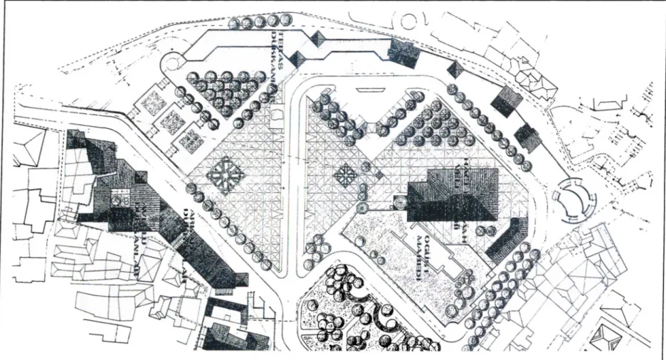
Figure 4.1 Location of Dikmen Valley... 56
Figure 4.2 Zones of the Dikmen Valley Project... 57
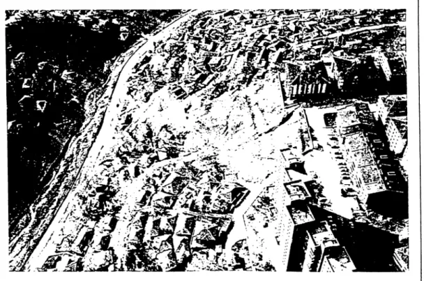
Figure 4.3 The south view of the Valley before the project... 59
Figure 4.4 The north view of the Valley before the project... 59
Figure 4.5 Land use of the Dikmen Valley Project... 62
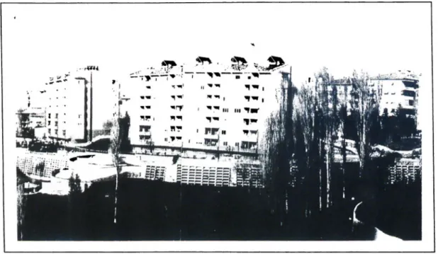
Figure 4.6 The new apartments buildings at the Ayrancı side of the Valley...64
Figure 4.7 The new apartments buildings at the Dikmen side of the Valley... 64
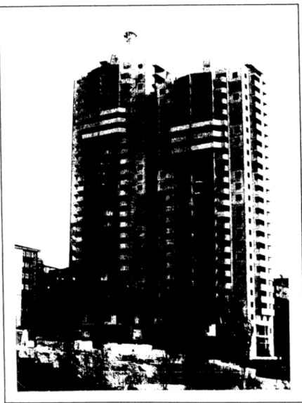
Figure 4.8 The luxurious apartment blocks being constructed in the Municipality Service Areas... 66
Figure 4.9 Culture Bridge... 67
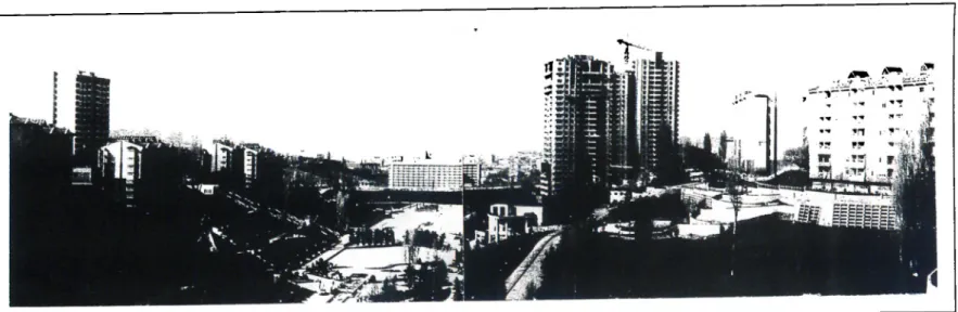
Figure 4.10 The current view of the first zone of the Valley... 71 Figure 4.11 The current view of the second zone of the Valley... 71
1. INTRODUCTION
In recent years, urban regeneration with its economic, cultural, technological and physical points of emphasis has become an important area of interest in urban planning and urban studies. Regeneration is defined as the re-investment in the social, economic, cultural and physical structure of existing built areas. It implies growth and progress and the infusion of new activities into declined parts of cities which are occupied by low- income groups and are no longer attractive to investors and middle-class households.
The cities experience periods of growth and decline with concomitant transformation of urban space from one economic and social use to another (Holcomb and Beauregard,
1981). With the transformation of urban space, the decay of inner city areas is an inevitable result. The problem of decay of inner city areas has been reversed in several cases, through housing regeneration policies since 1950s. Today, housing regeneration policies which direct their resources on the inner city residential areas have become an important task for the urban policy makers. These policies play an important role in the wider urban policy and should be handled according to broader urban interests.
There are various urban policies which discuss the economic and social implications of the intervention to the numerous resources of inner urban areas. Two distinct
approaches exist within the literature on urban policy and housing regeneration (Basset and Short, 1980). The policies that focus on encouraging economic growth distribute the benefits of this growth and improvements of physical environment among the higher income groups. The inevitable result of these policies is the displacement of low-income groups, “gentrification” . Gentrification is a process by which high-income class comes to reside in previously decayed inner city neighborhoods, renovating the housing stock and displacing poorer households. Gentrification is a normal outcome of a successfixl urban regeneration program which puts the principal purpose as to revive a profitable real estate market in the area (Williams, 1983).
On the other hand, there are others which take opposing stands towards the desirability of gentrification as an outcome. They argue that the benefits of renewal policies should concentrate on low-income groups directly or, at least, an equal distribution among different social groups should be targeted
Housing itself is a great problem for both developed and developing countries. Housing renewal policies in different cases in the world are directly affected by the economic and social structure of the countries. The historical context of urban change, economic possibilities and limitations, social implications for action, appropriate organizational structure and managerial approach should be considered carefully before any action for intervention, since these may vary from case to case, even in the same country. Instead of adopting a policy and implementing it, understanding the objectives of different
policies and their consequences would give more successful outcomes appropriate to the social and economic conditions of different countries . This is particularly the case in Turkey which suffers due to unrestricted increase of “gecekondu” (squatter) areas in most of its cities.
Due to the rapid urbanization rate, the squatters became one of the most important problem of the major cities in Turkey, as well as other developing countries. The amnesty laws that give title deed to squatter houses have particularly mushroomed these squatter settlements. Today, municipalities are aware of the problem and have begun to take precautions in order to prevent their construction. Nevertheless, the large numbers of squatters that have already been built in and around the cities constitute a crucial social and physical problem.
In recent years, regeneration became a popular subject in Turkey like it was in many other countries. Municipalities began to prepare urban regeneration projects especially to solve the problems that arose in the city centers due to squatter settlements. Dikmen Valley Housing and Environmental Development Project is one of them which can be identified as the largest squatter settlement regeneration project in Ankara. The project shows similarities with other cases from all over the world, but at the same time, it is different in terms of its points of interest and the unique model developed to solve the problem of squatter settlements. One of the main principles of the project is to distribute the profits of the regeneration project equally among the members of the society;
In the second chapter of this study, key issues concerning urban regeneration are handled. This chapter concentrates particularly on the physical and social aspects of housing regeneration. Hence, main approaches to urban regeneration and the most possible result of it, “gentrification”, are introduced with respect to their social implications and the displacement of the existing low-income residents of the neighborhood.
In Chapter Three, frame of the problem of squatter settlements in Turkey and urban regeneration in the case of Ankara with four large-scale regeneration projects will be analyzed. Brief historical evolution of squatter settlements is given in order to show the difference of the approaches to squatters in Turkey that is developed in time and to draw attention to the dimensions of the problem. The social and physical characteristics of squatter settlements are introduced to understand their culture and life styles.
The Fourth Chapter is devoted to Dikmen Valley Housing and Environmental Redevelopment Project. The project is introduced in terms of its objectives, basic
principles and evaluation. The participatory model applied in Dikmen Valley is very important. Thus, user participation and negotiations have been explored in order to understand the process and the powers that affected the project.
The remaining part of the fourth chapter is devoted to the research carried out in Dikmen Valley. In the research, changes in the socio-economic structure of Dikmen Valley after the housing and environmental development project are explored. The focus of this study is the socio-economic status of people presently living in the houses
constructed for the rightowners during the first phase of the project and their differences in order to affirm the existence of different socio-economic groups that reside in
Dikmen Valley in contradiction with the initial target of the project. This will be analyzed based on the assumption that urban regeneration process will result in a change in the socio-economic structure of regenerated neighborhoods. The data to study this research question has been collected through a survey. A questionnaire has been prepared and applied to people who are currently living in the houses of
rightowners. In the last part of the chapter, the results of the case study on Dikmen Valley are presented.
The study concludes with a discussion of some main concepts derived from the case study as well as the literature review, and some aspects of the regeneration of squatter settlements in Turkey.
2. URBAN REGENERATION
Urban regeneration is a recent phenomenon in Turkey. Therefore, it is necessary to look at its key issues in order to understand the current process considering Turkey’s cultural, social, economic and political particularities. In this chapter, issues in
neighborhood regeneration are introduced, concentrating on the physical and social aspects of the process rather than its economic, cultural and political issues.
2.1. Brief History of Urban Regeneration
Urban regeneration is neither completely new nor unprecedented. Cities experience periods of growth and decline with the transformation of urban space from one economic and social use into another. Although some attempts have occurred in Europe (Housmann’s renewal of Paris), the United States was one of the first countries which developed specific programs for urban regeneration and the pioneering studies in literature on this issue are mostly about these programs.
Over the last 130 years, major efforts have been made in the U. S. to counteract decay and to renovate cities. However, until the late nineteenth and early twentieth centuries there was not any considerable coordinated efforts on the part of local
governments, reform groups, and business interests with the intent of eliminating the physical aspects of urban decline (Holcomb and Beauregard, 1981). The first major urban regeneration efforts in the United States were the American Park Movement and the City Beautiful Movement which emerged as a response to high densities and environmental degradation brought about by urbanization and industrialization (Holcomb and Beauregard, 1981). Both of the movements emphasized the transformation of urban centers through the creation of urban parks:
Cities were encouraged to develop civic spaces surrounded by public buildings —libraries, city halls and post offices, museums, etc — all of which were to be joined by parks, tree-lined avenues and plazas. Urban parks were thought to provide city residents with a therapeutic environment in which they can contemplate nature and find mental well-being. Many cities, in fact, developed City Beautiful Plans (Holcomb and Beauregard, 1981, 6).
Ten years of experience on urban regeneration and the conflicts between the 1960s and 1970s have shown that bringing changes and needed innovations to struggle against urban decline requires integrated strategies and approaches (Holcomb and Beauregard, 1981). Therefore, approaches of urban regeneration which address all aspects of life —social, cultural, educational, political, economic— and facilitate provisions to meet the needs of people in a particular neighborhood or district are required (Krüger, 1993).
2.2. Main Approaches to Urban Regeneration
Couch (1990) describes urban regeneration as seeking to bring back investment, employment and consumption, and enhancement of the quality of life within urban areas. Urban regeneration is a natural process through which the urban environment undergoes transformation. All cities are in a state of transition, of becoming bigger, smaller, better, worse or may be just different, and much of the world is being shaken by political, industrial, economic, and social changes (Middleton, 1991). Thus, cities
are shaped over time by political, economic, and social forces which are reflected on organizational and individual decisions. In such argument, with concomitant
transformation of urban space from one economic and social use to another, decay of inner urban space is an inevitable result.
Although it can not be generalized.
... inner urban decay, crime, racial tension, riots, mass unemployment and falling standards of service provisions are some of the more obvious and disturbing indicators of a general and deep- seated deterioration in the social, economic, political and finance fabric of the city (Clark, 1989, 22).
Middleton (1991) looks through the process from population point of view and claims that there is an outward migration of younger and more skilled population in search of jobs elsewhere. The result is that, as Robson (1988) points out, trapped in inner-city
areas are old people, single parents, and unskilled workers, each of whom have their own version of “hell is a city.” Therefore, urban regeneration process sometimes is
Whatever the reason for intervention, there are certain prerequisites for action, as noted by Couch (1990). The prerequisites that should be known before action are the historical context of change, the economic possibilities and limitations, the social implications of action, the appropriate organizational structure and the managerial approach to adopt, and the physical opportunities and constraints presented by the circumstances (Couch, 1990).
Most of the sources emphasize the rehabilitation of infrastructure in regeneration. According to Robson (1988), investment in new and rehabilitated infrastructure is a clear need to reverse urban decline. Similarly, Button and Pearce (1989) argue that the restoration of infrastructure can enhance the welfare of those living in a run down inner city area by, for example, improving the appearance of the location, offering additional informal leisure opportunities, and frequently, removing potential hazards.
2.2.1. Redevelopment
called as the “back to the city movement” which could reverse the process o f urban decline.
The term redevelopment implies the removal of existing fabric and the reuse of cleared land for the implementation of new projects to enable opportunities and satisfactory living conditions. This approach is generally applied in areas in which buildings are in seriously deteriorated condition and have no preservation value. This
profit through sale and introducing higher income groups and commercial activities into city center which will result in tax revenues. All these benefits are distributed among developers and government.
This approach may result in total removal of settlement patterns and of life styles in existing fabric which may have a severe social and environmental cost. Even if the residents of redeveloped areas are rehoused, the transformation of neighborhood has psychological impacts upon that community. The cost of this transformation is not only “financial but social (loss of community ties, reduced proximity to fnends and relatives) and emotional (the trauma of displacement from familiar locations)” (Holcomb and Beauregard, 1981, 46).
In many cities, it is recently realized that the removal of great amount of existing housing stock is often counter-productive, given the tremendous housing demand which exists and the clear inability of existing institutions (and finance) to provide new housing on the scale desired. Instead, it is important to utilize these housing units, even if, at present, they are in poor condition (Steinberg, 1996).
2.2.2. Rehabilitation
Rehabilitation (widely used as conservation or preservation) may be accepted as the opposite of redevelopment. It implies preservation, repair and restoration of existing neighborhoods. Rehabilitation became an extensively used approach within
advantage of existing housing stock as a source for providing jobs, stimulating business activities, and revitalizing downtown areas (Sever, 1983).
There are several positive attributes of the rehabilitation of the buildings in urban centers such as;
- General revitalization of the city,
- Increased property tax base and revenues, - Support for the commercial business segment,
- Re-creation of community / neighborhood feelings in urban centers, - Reduction of energy outlay resulting from fewer commuting workers, - Increased use of neglected utility systems,
-Feelings of identity and pride of ownership” (Smith, B., 1983, 235).
There are also some disadvantages including the displacement of low-income people and an increase in demand for public services (police, fire, etc ).
2.2,3. Urban Renewal
The objective of urban renewal with the neighborhood approach is to improve the residential and living conditions of the population in old neighborhoods. In practice, urban renewal proceeds with great difficulty. Although it can not be possible to sum up all the problems of urban renewal, the most important problems encountered are social, financial, organizational, planning and phasing problems. Urban renewal tries to solve a social problem since the old neighborhoods have been neglected for many years. The people in the old neighborhoods have likewise been neglected. The worst neighborhoods are populated by the people with the lowest incomes. Urban renewal requires financial solutions since it takes a lot of money to remedy the neglect of old
neighborhoods. Urban renewal needs an organizational approach since in urban renewal projects both the municipality and the neighborhood encounter organizational problems. (Haberer, De Kleyn and De Wit, 1980). The urban renewal with
neighborhood approach should circumvent these difficulties.
Urban renewal should be studied in a wider context rather than economic functioning of the city or improving existing housing stock. The major principles of a successful urban renewal are explained by Carmon and Baron (1994) as;
... avoiding relocation of residents and demolition of the buildings (i.e. working with the present population and the existing housing stock); targeting resources at neighborhoods in need (rather than at individuals or households); integrating social and physical rehabilitation; decentralization and resident participation; and implementation through existing institutions (1467).
2.2.4. Revitalization
Urban revitalization is one of the dominant approaches to urban regeneration which emphasize neighborhood preservation and housing rehabilitation. According to Holcomb and Beauregard (1981), like earlier concepts (e g. urban redevelopment, urban renewal and urban regeneration) urban revitalization implies growth, progress, and the infusion of new activities into stagnant or declining cities which are no longer attractive to investors and middle-class households. It is assumed that by preserving the neighborhood and housing rehabilitation, the displacement and disruption of communities can be prevented to a certain degree.
2.2.5. Gentrification
Gentrification is an aspect of urban revitalization which has received considerable attention in both popular and professional literature. It is widely assumed that
physical and economic restructuring in the urban core will result in displacement and gentrification in surrounding neighborhoods.
The issues raised by gentrification have never really been settled, either in economics or in other social sciences (Redfem, 1997a). Gentrification is held to be impossible to define, that it is a “chaotic concept” (Beauregard, 1986). Gentrification has often been identified as “a means by which polarization is imprinted on the geography of the city, through two linked processes” (Lyons, 1996a, 341). One of these processes is the invasion of an area by high-status households, who upgrade the area and raise the land values within it. The other is the economic displacement of those who can no longer afford to live in the area, which may take several forms.
There are several arguments about when gentrification occurs. According to Holcomb and Beauregard (1981), gentrification occurs when there is a substantial replacement of a neighborhood’s residents with newcomers who are of higher income and who, having acquired homes cheaply, renovate them and upgrade the neighborhood.
Inmovers to gentrifying neighborhoods are, in some respects, different from incumbent residents (e g. in household structure and size, in age profiles, in racial composition, or in emplojmient status of household members). However, the shared and defining characteristics of gentrification everywhere is the socioeconomic change
through migration (Lyons, 1996b). Gentrification and revitalization refer to a change in household social status, independent of the housing stock involved, which might be either in renovated or redeveloped units (Ley, 1986). Definition of gentrifiers should not be limited by middle-class individuals, rather there are other kinds of individuals responsible for the physical transformation of urban landscapes. According to Smith (1979), other individuals are builders, property owners, estate agents, local
governments, banks and building societies.
There are certain factors, evident cross-nationally, without which gentrification may not have taken place, but of equal importance. Carpenter and Lees (1995) discuss that in the gentrification process, place has a relevant degree of significance. Nevertheless, for gentrification to be said to have occurred, several conditions must be fialfilled. Neil Smith (1979) explains this as: once the rent gap is wide enough, gentrification may be initiated in a given neighborhood by several different actors in the land and housing market. Rent gap is the disparity between the potential ground rent level and the actual ground rent capitalized under the present land use. Ley (1986) has a different approach; if downtown employment opportunities draw populations to the inner city, this population, as it gives political and economic expression to its own predilection
for urban amenity, will restructure the built environment and accelerate the gentrification process.
Another argument about gentrification to occur comes from Redfem (1997b). He states that, four factors must exist together for gentrification to occur:
First, cities in which gentrification occurs must exhibit residential social spatial segregation. Second, properties, and by implication neighborhoods also, (from the first condition above), that are liable to initiate the gentrification process must have at the some point in the past been abandoned by the middle class, either as occupiers or as owners. The third condition is that the financing for gentrification comes primarily out of borrowings rather that savings, fiature income in other words rather than past income. The fourth condition is that gentrifiers must have material as well as the financial wherewithal to renovate a property (1335-1336).
Each factor has implications for action. According to Nyden and Wiewel (1991), if one believes that gentrification is a “panacea for inner-city neighborhoods,” then one argues for policies and programs that encourage it, calling it reinvestment,
revitalization or rehabilitation (28). If, on the other hand, one believes that the uneven consequences of gentrification are unduly for low and moderate, usually minority, households and communities, then one argues that policies and programs should be pursued to curtail gentrification (Nyden and Wiewel, 1991). Gentrification disputes communities and displaced residents.
Overall, business interests have dominated the negotiations among government, community and the private sector on the content of redevelopment. They have been supported by elite and middle-class consumers seeking downtown “improvements” and attractive, centrally located housing. Especially in the housing renewal process, the stronger parties occupy the best position in the housing market, and they
eventually take over the best housing in the most attractive parts of the neighborhoods (Van Kempen and Van Weesep, 1994). Neighborhood and lower-income groups have also received some gains in some places from redevelopment. Generally, however, the urban poor, ethnic communities, and small businesses have suffered
from increased economic and locational marginalization as a consequence (Fainstein, 1994).
Gentrification, thus, poses a dilemma for policy makers. On the one hand, they wish to attract and retain middle- and upper-class residents in the central city. On the other hand, to make new room for these new residents, the poor are displaced. Rather than seeking to stop gentrification, some policymakers urge that greater effort be made to monitor the extent of displacement and to improve mitigation programs and funding. Their intent is to assist original residents in remaining and renovating their homes and to help those who leave to relocate successfully (Holcomb and Beauregard, 1981).
Gentrification does not unfold as a single process. In different neighborhoods, even within a single city, the process involves different actors and proceeds with varying consequences. Moreover, it is not a process which, once started, continues until the neighborhood is totally gentrified (Beauregard, 1990).
2.3. Social Issues in Urban Regeneration
In this section, mainly two social issues, displacement and participation in the urban process, are introduced since these two concepts are dominated in neighborhood regeneration and directly related with the case studied in this thesis.
2.3.1. Displacement
One important concept of urban regeneration is social justice. Social justice has a spatial component. Just like the unequal distribution of the goods and services, places are also distributed unevenly among groups and individuals in a society (Holcomb and Beauregard, 1981). Natural resources are unevenly distributed so that, the cities near them have the greatest locational advantages.
The term equal is important for social justice. Urban regeneration changes both the social and the spatial distribution of goods and sources. But, it usually does not entail a redistribution which favor low income people of the neighborhood (Holcomb and Beauregard, 1981). Rather, it further concentrates resources in areas which are dominated by upper- and middle-class people and reinforces their control over these urban spaces.
The process of urban regeneration is controlled by a small number of groups and organizations. The consequences of urban regeneration are as exclusionary as the process which creates them. More of land and property in the central business district are captured by large investors and developers, real estate investors and corporations. Services, recreational and entertainment activities, and expanded employment
opportunities are designed for the middle-class. Physically, the downtown becomes upper- and middle-class space, reserved for their use and enjoyment, while the poor are pushed into less attractive parts of the city (Holcomb and Beauregard, 1981).
A major cost of urban regeneration is that, people often loose environments to which they have developed strong emotional attachments. This loss of attachment occurs when residents are displaced from their homes both by gentrification and by redevelopment. From the psychological perspective, environmental transformation brings a sense of loss which stems from a sense of identity and a sense of belonging when a place, one has know for many years, is changed. It is generally recognized that displacement from familiar locations translates into drastic changes in lifestyles
and requires long-term readjustments which can cause serious psychological trauma, especially for the most vulnerable portion of the population like young children and elderly (Holcomb and Beauregard, 1981). The loss of contact with the familiar environment to which people have developed emotional attachments may occur both when residents are displaced and when familiar environments are radically altered by revitalizing activities.
People displaced by regeneration are simply the victims of the process. Their loss is viewed as a price which must be paid for revitalization. While the government might intervene to compensate such victims for part of the economic cost of displacement, loss of place requires long term adjustment and it may never be captured (Holcomb and Beauregard, 1983).
The image and symbolism also have a share in the uneven spatial investment in the city and in the uneven development of urban space. Middle-class symbols are
articulated and highlighted, those of the working class, poor, ethnic and racial groups are neglected. This leads to the disruption of the local culture which represents the
collective expression of shared history, traditions, values and the way of life. The disappearance of the physical and social structure of a particular culture may lead to a decline of this culture and also may result in a decline of urban culture, since the city is composed of several different social groups.
Declining cities need to receive private investment and government programs to stem deterioration and to revive them economically (Holcomb and Beauregard, 1981). But some precautions must be taken against uneven distribution of benefits of urban
regeneration. The quality of life should not deteriorate for those who stay. Attachment to place deserves recognition and social networks should not be destroyed. Equitable urban regeneration requires the active support of government bodies and political actions by working-class organizations.
If regeneration is necessary, government should intervene, first to make
redevelopment procedures more democratic, and, second to spread benefits and costs of change across both space and social groups. Lastly, government should devise mechanisms for providing greater social control over redevelopment (Holcomb and Beuregard, 1981).
2.3.2. Participation in the Urban Process
Participation and involvement of the residents are essential for the success of a rehabilitation program, and should be encouraged with regard to environmental and housing issues. Urban regeneration needs to look at the key issues of community
involvement in the sense of active participation of individuals, groups and
communities in the process of shaping their environment and the quality of their living conditions. Following the principal “for the residents - with the residents” it became the explicit objective of the renewal program to be oriented towards the needs of the present residents and the users, and to be planned and carried out in co-operation with them (Krüger, 1993).
First of all, local people must be involved to the process, giving them a voice in the action (Donnison, 1993). But, involving local people means that a proxy client of an organized kind is needed, representing the residents and the many active community groups to be found even in the most deprived and impoverished neighborhoods.
Multi-agency approach, that means the staff of different departments established in a joint collaborative presence in the working area accessible to local people, is another important feature of urban participation. Community based style of operation which gives the local people who actually experience and suffer the problems a voice will give better solutions for the local people of regenerated neighborhoods according to Donnison (1993). Local authorities play a key role for addressing the issues about participatory model.
A rational individual will participate in a community based organization when the benefits of participating are greater than the costs. Length of residence, residential stability, and the number of friends and relatives in the community are the key factors that influence attitudes and behavior toward the community. The longer an individual
resided in a community that exhibits residential stability, the more likely he or she will participate in community-based organizations, feel a strong sense of community attachment, and develop local friendship ties. Therefore community stability at the individual and community levels is the primary condition that promotes community participation (Reingold, 1995).
Social implications of action should be considered well since business interests have dominated the negotiations among government, community, and private sector, redevelopment actions have been supported by elite and middle-class consumers seeking down “improvements” and attractive, centrally located houses as explained by Fainstein (1994). That means the profits of urban regeneration process are unevenly distributed among the members of the society. While stakeholders, real-estate agencies, middle- or high-income people gain much more profit, the low-income groups suffer from the consequences of the process. In order to overcome this social problem, there is a need for better communication and negotiations with all
population groups.
The next chapter presents the main urban regeneration efforts in Ankara especially held towards to solve the problem of squatter settlements. Four large-scale projects will be introduced with their site, objectives, model developed and critiques in order to draw main frame of urban regeneration in Ankara and to conceive the
municipality’s approach to regeneration, thus to understand better that the process of regeneration in Dikmen Valley Housing and Environmental Redevelopment Project.
3. URBAN REGENERATION IN ANKARA
Today, urban regeneration is a popular subject in Turkey, as well as in many other countries. Municipalities have begun to prepare urban regeneration projects especially to solve the problems raised due to squatter settlements which have been already mushroomed in the city centers. Since World War II, rapid social and economic changes accompanied by changes in the physical realm have been taking place in Turkey, like in other parts of the world, as a result of rapid urbanization of the country, largely due to rural-to-urban migration (Erman, 1997). When this migration from rural areas to larger cities started, the governments were not capable of
providing employment, basic services and housing to the newcomers.
In the face of insecure employment opportunities, the security of a shelter becomes a critical and basic problem. The housing shortage and high rents in cities due to high urbanization rate lead low income families and the migrants, who can not afford legal housing in cities, to solve their own housing problem through illegal ways. The most common solution is building their houses (squatters) on unplanned areas or on
publicly or privately owned land, or on geographically undesirable sites, such as steep slopes, river beds, etc.
Squatter settlements, named variously in different countries, represent urban areas of great importance in many places. Squatter settlements express culture and the latent and symbolic aspects of activities; allow culturally valid homogeneous groupings, locating people in physical and social space; provide appropriate symbols of social identity and appropriate social structure (Rapoport, 1977).
Although squatter settlements show similarities all over the world, it is important to evaluate the term in the special cultural, economic, social, political set up of a country, furthermore, in different regions of a country. Before going into details of the urban regeneration efforts in Ankara, it is important to examine squatters in the Turkish context their social and physical characteristics which have close relations with the life style of the squatter people. Hence, in the following section, historic evolution of the concept in the Turkish context will be discussed briefly in order to show the
dimensions of the problem of squatter settlements in Turkey changes in the
approaches to the issue of squatters, and their social and physical characteristics. The life style of people who live in these areas will also be examined in order to
understand the effects of the Dikmen Valley Project on their daily lives.
3.1. The Turkish Context of Squatter Settlements
“Gecekondu”, the Turkish version of squatter housing, began to emerge during the 1940s. The term “gecekondu” refers to buildings constructed on land belonging to others without the consent of the owner and without regard to either legislation dealing with housing and construction, or general regulations (Heper, 1978). A
decade later, in the 1950s, the “gecekondu”s (built overnight) started to mushroom in the major cities of Turkey (Heper, 1978).
Primarily, there are two important reasons (push and pull factors) behind migration from rural to urban lands: low productivity, low incomes in agriculture,
mechanization and fertilization in agriculture, uneven distribution of land, scarcity of available land for the increased population in rural areas, and lastly the wars are the push factors. The attraction of the cities due to industrization, improved service sector, better education opportunities, and the better living conditions constitute the pull factors which cause migration from rural to urban areas.
In 1950-60S, as the demand for cheap labor in industry, commercial and especially in service sector increased, the role of the “gecekondu” people who were employed as unskilled, hard, unorganized workers in the economy gained importance, and the “gecekondu” areas became indispensable parts of the city (§enyapih, 1983).
The 1966 “Gecekondu” Law has set the framework for the Government’s
regularization policies that involve granting title deeds to the inhabitants of illegally occupied or subdivided land and providing infrastructure and services (Pamuk, 1996). Hundreds, even thousands of squatter houses have been built in large cities
particularly in periods that precede elections and during periods of political turmoil which result in the weakening of control.
Politicians attempted to take advantage of the voting potential of the “gecekondu” population by legitimizing the already existing “gecekondu” settlements (Keleş, 1990). Partisan behavior of the politicians, while legitimizing the completed squatters,
encouraged the constructions of new ones. So, the belief that once a squatter house is built, one would somehow obtain a title deed, also helped to accelerate the migration to urban areas.
Regularization programs and amnesty laws coupled with rapidly rising land prices led to fundamental changes in “gecekondu” settlements. The era of traditional
“gecekondu” construction changed considerably in the last decade in Turkey (Pamuk, 1996). The motive behind has also changed from the need to find shelter to land speculation, and rent extraction and maximization (Şenyapılı, 1983). Some
“gecekondu” dwellers have greatly benefited from newly gained development rights, by applying the “build and sell” system on the plots they have occupied. In this process, the original squatter residing in a single-story gecekondu could become the legal owner of several flats (Pamuk, 1996). Landowners transferred the land to a builder for the construction of multistory apartment buildings and the contractor in return gained ownership rights for a previously agreed percentage of flats.
One important evalution in the history of the “gecekondu” is the change in the approach to the “gecekondu” people. Previously, “gecekondu”s were considered to be a solution for low-income families who can not afford legal housing in cities, and accepted as legitimate though they were not legal. Today, middle and upper-middle classes regard people who live in “gecekondu”s as benefiting from urban land
speculation, and deteriorating public lands with the help of amnesty laws and
implementation plans. So, “gecekondu” people are not poor and miserable any more.
Throughout the history of “gecekondu”, priorities of the “gecekondu” people, have also changed. At the beginning, the primary aim of the first generation was to settle and find shelter in the city. However, priorities of the second and third generation who dwell in “gecekondu”s have shifted towards benefiting from everything that the city offers.
It is important to evaluate physical characteristics of “gecekondu” since they are directly related with the current physical fabric of the squatter settlements in Turkey, thus the cities in Turkey. Construction usually occurs in an incremental mode (Heper,
1978). When the home owner is reasonably assured of the survival of a home, a considerable part of the family income is spent on home improvements. Most of the labor is carried out by the owner, or with the assistance of craftsmen. The squatter
dwelling begins as one room (single space) dwelling possibly with an auxiliary wet area, and grows into more rooms, kitchen and toilet as the family size increases due to births, relatives and friends arriving from villages. These houses allow for upgrading and change as the inhabitants’ lifestyles and priorities change since their plans are flexible and open-ended. Changes and additions that reflect kinship, social
relationship, clustering of extended families and other groups, the need for unmarried sons to remain in the parental home, and other cultural imperatives, are achieved easily.
Formal and informal, public and private zones are separated so that an intimacy gradient is set up, and the houses incorporate transitional spaces with various zones from the street to the most intimate spaces. Security is another major determinant of
spatial organization, the perimeter walls providing both security and privacy are used. The open patios provide for many activities. Dwellings are shelters with most living done outdoors (Rapoport, 1977). Courtyards of the squatters are used as playgrounds, meeting places or places to breed farm animals.
Having explained the physical characteristics of “gecekondu” briefly, there is a need for exploring the social characteristics of it since the two characteristics are closely interrelated with each other.
In the case of “gecekondu”, people construct their own dwellings, usually with the help of relatives who have settled there before and neighbors, so that they can occupy their houses right away (Yörükan, 1966). Such solidarity among people can be observed in various other contexts and at various times.
The population of these areas are quite heterogeneous; they come from all parts of the country, belong to different age groups, have different occupations, and are
predominantly villagers. Despite the fact that they acquire a profession and specialize in one field or another, there is a considerable number of people who baked their own bread, breaded farm animals such as chicken and cows, and grew vegetables. Until they are integrated with urban life, these people who come from villages pursue a
rural way of living and continue their rural behaviors and attitudes which gives the cities a semi-rural appearance (Yörükan, 1966).
This heterogeneous population have acted in unity at times when the survival of the settlement was at stake. They got together whenever there is a real emergency situation, such as a threat of demolition of their houses due to the lack of title to the land (Heper, 1978). They support each other to deal with the difficulties of city life.
Social interaction among the “gecekondu” people is very important. Associations based on common origin, or any other criterion selected, help people organize their lives and adjust to urban life (Rapoport, 1977).
3.2. Current Urban Regeneration Efforts in Ankara
Ankara, the Capital, has been the most vulnerable from squatter settlements of all big cities in Turkey because of its almost total lack of housing for low-income people, except for the rundown houses of the citadel region (Şenyapıh, 1983). Nearly two- thirds of Ankara’s total population currently live in squatter dwellings (Table 3.1), and about a third of the population of other major cities of Turkey resides in squatter dwellings. (Keleş, 1990).
Table 3.1 "Gecekondu"s in Ankara Years 1950 1960 1966 1970 1975 1978 1980 1990 Number o f "Gecekondu" 12000 70000 100000 144000 202000 240000 275000 350000
"Gecekondu" Population Percentages
62400 364000 520000 748000 1156000 1300000 1450000 1750000 21.8 56 57.4 60.6 64.9 68.4 72.4 58.3
Source; Keleş, R. 1990. Kentleşme Politikası. Ankara; İmge Kitapevi.
Throughout the Republican Period the municipalities have tried to find solutions to the increasing problems posed by the high rate of growth and the rapid urbanization in cities especially after 1950’s. This process concentrated mainly on major metropolitan areas, caused rapid changes in the physical fabric of the cities and there emerged unbalanced and uncontrolled urban dispersal. In the 1980s, a number of measures has been taken with a view to enable the municipalities, especially those in big cities (Ankara, Istanbul and İzmir), to provide services more adequately. In this context. Metropolitan City Municipalities were being established in big cities (The Greater
Ankara Municipality, 1992a).
Ankara, the capital city, is the first city in Turkey that had a planned growth. Indeed, Turkey’s first urban development plan was drawn up for Ankara in the 1930s, the Jansen Plan (The Greater Ankara Municipality, 1992a). But this urban development plan became inadequate as the population growth rate of the city far exceeded the forecasts.
The changes both in the physical fabric and socio-economic structure of the cities lead planning authorities to search for new approaches to urban problems. This approach originates from the need to improve existing urban environment. Today, public authorities are more conscious of the necessity for regeneration of urban environment and the improvement of life in the cities. Thus, urban renewal became much more popular than other urban regeneration approaches mentioned in the second chapter. This does not mean that the other regeneration approaches are totally neglected; regenerative operations under different names such as redevelopment, rehabilitation, etc. for city centers, housing areas and old and historic urban sites and green area have been undertaken in major cities of Turkey.
In late 1980s, regeneration of the inner city areas by also increasing green areas became a policy concern for both local and central authorities. Urban development plans including master plans which shows the major land-use allocation and gross densities for existing and future land-uses, and implementation plans which define the building blocks, respective densities and future building construction rights have been prepared during 1980s. In 1986, an urban development plan was prepared for Ankara Metropolitan Area by a planning team from the Middle East Technical University (METU). As part of the general research carried out by the City and Regional Planning Department of METU to determine the basic planning strategies and approaches for the Ankara 2015 Structural Plan, the development of an 8-10 km green belt around Ankara was proposed in order to create air currents and to help prevent air pollution. As a matter of fact, there existed a decision coming from Jansen Plan that this belt should be widened towards the city center as much as possible by
following the valleys which penetrate through the developed zones, for these valleys to be evaluated as green areas connecting a green belt which was to surround the city, to the center of the city.
In this respect, the Greater Ankara Municipality developed many “urban
transformation projects” including infrastructure projects such as Ankara Lightrail Transportation System (Ankaray), metro, sewage system project etc., regeneration projects such as Dikmen Valley, Portakal Çiçeği Valley, Öveçler Valley, İmrahor Valley, Ulus Historic Center Conservation and Rehabilitation Project, Hacibayram Project, etc. In this general framework, firstly the regeneration project areas were covered by squatter houses. So, they were physically developed and hard to transform (Dündar, 1997). Secondly, in three of the projects (Dikmen Valley, Portakal Çiçeği Valley and Öveçler Valley) these squatter houses were settled in valleys which are termed to be the breathing corridors of Ankara City.
It is known that the city of Ankara, geographically and topographically, sits on a large bowl like formation and that the surrounding hills and valleys carry great importance
in providing the city’s air circulation. Although Ankara has great potential for creating a green city with its topographic characteristics, it is, including several valleys, mostly covered with squatter houses. In 1970’s, while major valleys in Ankara (Seymenler, Papazın Bağı in Gazi Osman Paşa District and Botanik) were transformed into urban parks. Dikmen Valley, Portakal Çiçeği Valley and Öveçler Valley were left
uncontrolled and became places where unplanned, unlicensed squatter houses were erected. Due to local plans which did not consider both sides of the valleys, the
squatter dwellings mushroomed at the periphery of both the planned and unplanned areas.
The cases of urban regeneration projects developed in Ankara were selected among the ones that show similarity in their aims, sites, objectives of the projects, etc., but
mostly projects which aimed to solve the problem of squatter settlements will be introduced. While Dikmen Valley Housing and Environmental Redevelopment Project will be broadly explained, the others. Portakal Çiçeği Valley Urban
Development Project, İmrahor Valley Recreation Area, Öveçler Valley, Hacibayram Environmental Development Project will be shortly introduced with their project areas, objectives and basic principals of the projects and the model developed for each of them. The discussions about the projects will be concentrated on physical and social aspects rather than economic, and political issues.
3.2.L Portakal Çiçeği Valley Urban Development Project
Portakal Çiçeği Valley has been located in the southwest of Ankara lying among two densely populated housing quarters, Çankaya and Ayrancı. The Valley is bordered by Kuzgun Street on the north, the intersection of Hoşdere Avenue and Cinnah Avenue on the south, and parts of Portakal Çiçeği Street, existing apartment buildings. Piyade and Platin Streets on the West. Viewed within the Ankara Valleys System, the site is located between Dikmen Valley, Botanical Park and Seymenler Park. The site constitutes of 11 hectares.
Portakal Çiçeği Valley was once mostly publicly owned, partly unavailable for settlements due to topographical thresholds (Fig. 3.1). The first planning efforts for this Valley came in 1968. This was actually a plan modification which was prepared
under the pressures of the landowners in order to open green areas to housing (Dündar, 1997).
Fig. 3.1 The View of the Portakal Çiçeği Valley before the Project
Source; Göksu, F. A. 1993. “Portakal Çiçeği Vadisi Kentsel Gelişme Projesi” Ankara Söyleşileri. Kasım-Aralık, Ankara; Mimarlar Odası Ankara Şubesi Yayınlan.
Later the Valley has been transformed into urban property due to local
implementation plans that were adopted by various municipalities and ministers, and private ownership increased during this transformation (Göksu, 1993). In 1989, a project named as Portakal Çiçeği Valley Urban Development Project has been
prepared by the Greater Ankara Municipality in order to prevent all kind of illegal developments, gain a new green area for Ankara (Fig. 3.2).
Fig. 3.2 Portakal Çiçeği Valley Urban Development Project
Source; Göksu, F. A. 1993. “Portakal Çiçeği Vadisi Kentsel Gelişme Projesi” ^wAarra
Söyleşileri. Kasım-Aralık, Ankara; Mimarlar Odası Ankara Şubesi Yayınları.
The objective of the project can be summarized in three broad categories;
1. To gain a green valley for Ankara with contemporary and high urban standards.
2. To realize a self financing mechanism rather than public financing without reserving a great amount of financial resources,
3. To stimulate the landowners to participate to the project with an argument in return for a share from the constructions in proportionate to their land (Göksu, 1993) (translated by the author).
For these purposes, “Portakal Çiçeği Valley Project Development, Operating and Trade Company Inc.” (PORTAŞ, shortly in Turkish) has been founded by the individuals and the municipality as shareholders (The Greater Ankara Municipality,
1992b). PORTAŞ would assume the functions of land development, project administration and urban renewal. The working principal of PORTAŞ can be summarized as:
“PORTAŞ would give the investments in the project in a given period of time to a constructor for a certain percentage. The expenses of PORTAŞ and the project expenditures would be covered by the constructors. All the investments up to then had been covered by the investor. The rents would first be spend for the management of the compound and the project expenditures, and the remaining would be distributed to the shareholders according to their shares. In other words the difference between the portion which would be taken from the constructor in return for flats and the portion which would be given to the landowners would be the profit of PORTAŞ. This profit would also be distributed to the shareholders. So neither landowners nor the municipality would make a financial contribution for the project” (Dündar, 1997, 111).
Moreover, there would be representatives of landowners in the board of directors and board of control of PORTAŞ. So, all the project participants would be involved in all levels of project evaluation. In fact all decisions and principles of the project were realized in agreement with the project participants who became shareholders in this case (Dündar, 1997).
In the plan prepared by PORTAŞ, 70 percent of the Valley would be designed as green area which is assumed to protect the natural character of the Valley to positively affect the climate of the region and Ankara. A landmark named ANSERA would exist in the Valley. In the ANSERA Culture and Trade Center, there would be social, cultural and commercial activities such as cinema, theater, art galleries, art ateliers, bowling and billiard saloons, shopping units, restaurants and cafes take place. In the Portakal Çiçeği Valley Urban Development Project, 220 luxurious housing units existed with the purpose of distributing to the landowners in return for their shares, and financing the investments in the project.
This project realized by public-private collaboration aiming to create a contemporary recreation area to the city is in fact a market model according to Altaban (1993). Altaban stated that;
“This model, as a result, can create an organized and even attractive green pattern, moreover, the landowners, adjacent but not in the Valley, can increase their expected benefits. Yet, to name the market mechanism in this model as “expropriation in return for rent” may damage the principle of public benefit which is the base of expropriation, and even dangerous. It is dangerous because, it opens way to bargains and gains of property rights by private landowners in the improvement applications of municipality directed for public use and services which is not easy to control” (1993, 81) (translated by the author).
Öveçler Valley Project is an important part of the South Ankara Project. The project area constitutes of 604 hectares. It is bordered by Çetin Emeç Avenue on the north. Dikmen Avenue on the east and Konya Road on the west. Starting with the local plans of 1975, the site has turned into a disorderly housing area (Fig. 3.3).
3.2.2. Ö veçler Valley
Fig. 3.3 The View of Öveçler Valley before the Project
Source: Özdemir, K. 1993. “Güney Ankara; Konya Karayolu-Dikmen Caddesi Arası Planlama Çalışması; Ankara Söyleşileri. Kasım-Aralık, Ankara: Mimarlar Odası Ankara Şubesi Yayınları.
The planning area has a silhouette zone perceived from a large part of the city, and contains a topography in which many riverbeds reside. The site has been occupied by “gecekondu”s for over 30 years. These “gecekondu”s, one or two stories high, have been spread out over the Valley’s sides and hills. The objectives of the project can be summarized as;
1. To transform Öveçler Valley, which is one of the most important parts of the Ankara Valleys System, into recreational areas to serve the whole city, 2. To involve the other small scale valleys lying along Konya Road for the benefit of the region by transforming them into green areas for social usage (Metropol İmar A.Ş., 1994) (translated by the author).
For these purposes, a project was prepared by the Greater Ankara Municipality and the Çankaya Municipality (Fig. 3.4).
Fig. 3 .4 Öveçler Valley Project
Source: Metropol İmar A.Ş., 1994. M etropol İmar 1989-1994. Ankara. Pelin Ofset.
The proposed plan reserves the valleys and the steep slopes of these valleys which are topographically unfit for settlement as green areas and green corridors in which air can circulate. In the project, there would be housing areas constituting 203 hectares.
The housing areas were planned as point concentrated clustered houses distributed throughout the area in which open areas existed. The area to the east of Konya Road has been proposed as a Business Area which would consist of government
establishments, commercial bureaus, exhibition centers, media buildings and necessary services. The areas surrounding Anadolu Boulevard, which carries a great importance and passes through the site east to west, is proposed for commercial, touristic,
entertainment, recreational usage and health services.
The implementation plan, prepared in six months, has been presented to the
inhabitants of the Valley in 1993. The worries of the Valley’s inhabitants over the plan concentrated mainly on the general distrust towards the public authorities and the possible future losses through expropriation of a large amount of area reserved for green areas and social services (Özdemir, 1993).
Some critiques about the context of the project that can be generalized through all the urban renewal efforts to overcome the problem of squatter settlements comes from planning authorities. As İdil has stated,
“One of today’s most important urban problems is efforts to improve the negativities of the current implementation plans developed over time, and South Ankara Project is one of such projects that aims towards this goal. Neither the Greater Ankara Municipality nor the local municipalities dare to cancel the implementation plans that give various benefits to “gecekondu” owners. Indeed, they are aware that the plans are not in accordance with the “Improvement Laws and Regulations” in shape and context. Instead, they accept the construction rights given to “gecekondu” owners as acquired rights in places where implementation plans are executed. If professional chambers, municipalities, government and media can create an effective corporation and dialog, a solution to this problem might be found; if not, urban renewal opportunities would be created to a very limited
extend with the Models tried in Portakal Çiçeği and Dikmen Valleys” (1993, 30) (translated by the author).
idil (1993) also criticized the conceptual design principles of the project, and stated that;
“The planning site contains spatial qualities with both its rent potential and special morphology that allow rich urban design and various transformation models. When viewed with these properties in mind, the proposed plan carries the correct principals in general. Yet, the design presented in 1/2000 scale site plan is open to discussion. This model which proposes the emptying of bottom of Valleys and constructing high blocks on the slopes does not seem to have taken into consideration the city silhouette and the rich potential of the site” (30) (translated by the author).
Today, Ôveçler Valley and some parts of Konya Road area in which the property ownership seems as much complicated and the topography more problem bound have been set aside as “ Special Project Areas”, awaiting further organizations and financial models.
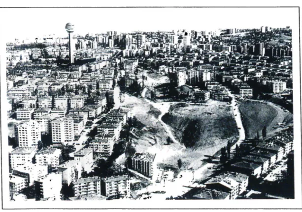
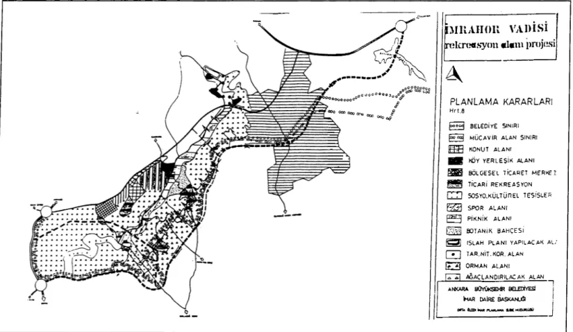
3,2.3. imrahor Valley
imrahor Valley, within Mamak and Çankaya Municipalities’ borders on the southeast of Ankara, is a large valley that can meet the city’s area needs to a great extent. The borders of the planning site are determined by Oran Road on the west., Ankara Highway and Doğu Kent (Southeast Ankara Urban Development Project), Türközü Quarter on the north and Eymir lake and METU Forest on the southeast (Fig. 3.5).