Measurement Based Statistical Channel
Characterization of Air–to–Ground Path Loss Model
at 446MHz for Narrow–Band Signals in Low
Altitude UAVs
Burak Ede
∗†, Serhan Yarkan
∗‡, Ali Rza Ekti
∗§, Tunc¸er Baykas¸
¶, Hakan Ali C
¸ ırpan
†, Ali G¨orc¸in
∗k∗ Informatics and Information Security Research Center (B˙ILGEM), T ¨UB˙ITAK, Kocaeli, Turkey
† Department of Electronics and Communication Engineering, Istanbul Technical University, ˙Istanbul, Turkey
‡ Department of Electrical and Electronics Engineering, Istanbul Commerce University, ˙Istanbul, Turkey
§Department of Electrical and Electronics Engineering, Balıkesir University, Balıkesir, Turkey
¶ Department of Electrical and Electronics Engineering, Medipol University, ˙Istanbul, Turkey
k Faculty of Electronics and Communications Engineering, Yıldız Technical University, ˙Istanbul, Turkey
Emails: [email protected], [email protected], [email protected], [email protected], [email protected], [email protected]
Abstract—Powered by the advances in microelectronics tech-nologies, unmanned aerial vehicles (UAVs) provide a vast variety of services ranging from surveillance to delivery in both military and civilian domains. It is clear that a successful operation in those services relies heavily on wireless communication tech-nologies. Even though wireless communication techniques could be considered to reach a certain level of maturity, wireless communication links including UAVs should be regarded in a different way due to the peculiar characteristics of UAVs such as agility in 3D spatial domain and versatility in modes of operation. Such mobility characteristics in a vast variety of environmental diversity render links including UAVs different from those in traditional, terrestrial mobility scenarios. Furthermore, UAVs are critical instruments for network operators in order to provide basic voice and short messaging services for narrow band communication in and around disaster areas. It is obvious that such widespread use of UAVs under different scenarios and environments requires a better understanding the behavior of the communication links that include UAVs. Therefore, in this study, details of a measurement campaign designed to collect data for large-scale propagation characterization of air–to–ground links operated by UAVs at 446MHz under narrowband assumption are given. Data collection, post-processing, and measurement results are provided.
Index Terms—UAV, Channel Modeling, Measurements, Path Loss
I. INTRODUCTION
Ubiquitous access has become an essential part of modern daily life. Services, applications, devices, and even products are equipped with wireless communication interfaces in such a way that diverse fields and domains are connected anywhere, anytime. In parallel with the escalating demand for high data rates, everywhere connectivity with mobility support becomes
This paper has been accepted for the presentation in the 2020 IEEE 91st Vehicular Technology Conference (VTC2020-Spring).
an indispensable design requirement for both contemporary and emerging wireless technologies. Although, it is expected that these wireless technologies should support crystal clear audio for voice, high–definition video downstreaming, very– low latency and 4K online gaming, low-power consumption transmission, and so on, it is more important to provide service on mission critical scenarios. Obviously, such an aggressive set of requirements comes at the expense of several conflicting list of parameters. Furthermore, realization of these requirements necessitate utilization of crucial resources such as bandwidth and power.
The conventional strategy to tackle the aforementioned uti-lization problem is reusing of resources as frequent as possible. Cell splitting, antenna sectoring, and small cell concepts are prominent examples to increase capacity via effective use of available bandwidth, reduce transmit power and impact of interference. There are products in the market regarding small cell (microcell, picocell, femtocell in the sense of metro femtocells, public access femtocells, enterprise femtocells and class 3 level femtocells, etc.) solutions which mainly rely on fixed deployment. However, with the emergence of unmanned aerial vehicles (UAVs), a paradigm shift has been experienced in wireless communication communities in many aspects. Considering its agility in 3D spatial domain and versatility in modes of operation, UAVs bring about almost a completely novel perspective in contemporary wireless mo-bile radio communication systems. Ranging from emergency communications to routing and relaying, UAVs are consid-ered to be promising solution candidates in various wireless communication scenarios. In addition, the emerging concept of Internet of Things (IoT) mandates extending the wireless radio coverage to diverse (and relatively harsh propagation) environments. In the presence of such a vast variety of
gation environments, a successful wireless communication link depends on transceivers which rely on extended measurements and corresponding designs [1].
In the literature, there has been a significant attention in UAVs and measurement campaigns including several modes and scenarios. Considering the transmission modes akin to terrestrial ones, air–to–ground and air–to–air are the two prominent classes [2]. Among these two, air–to–air class needs further investigation due to the aforementioned reasons relevant to UAVs modes of operations [3, 4]. On the other hand, air-to-ground could be considered to be a transition class since it contains both terrestrial elements and UAVs simultaneously. Air-to-ground class consists of line–of–sight (LOS), nonline–of–sight (NLOS), and obstructed line–of–sight (OLOS) [5]. Of course, a comprehensive air–to–ground model requires the probabilistic transitional states for LOS, NLOS, and OLOS cases to be defined as well [6–8]. It is obvious that further analysis is required to have an extended model which takes into account shadowing as an additional parameter [9–11]. A very detailed collection of studies present in the literature could be found in [12]. Beside statistical models which depend heavily on theoretical derivations [13], there are exact [14] and numerical approaches in determining the propagation characteristics as well. Especially ray tracing method that runs in downtown scenarios with the extension of building heights is employed very frequently [4, 15].
In the mission critical scenarios, where the utilization of UAV base stations (BSs)/access points (APs) such as dis-aster/public safety regions, rural areas and downtown areas where the total failure of communication infrastructure would lead to catastrophic events in terms of wireless communica-tion, finding a rapid and cost–effective recovery solution that utilizes narrow band voice channels will be an important task. There have been some commercial services offered by cellular operators which claim to employ drones as hovering base stations in order to provide coverage in emergency scenarios and/or when disaster strikes. However, one of such operators which claimed to have UAV base stations could not provide service for a while after an earthquake of magnitude of 5.8 hit Istanbul, Turkey, on September 27th, 2020 [16]. This instance revealed that establishing communication via UAVs in a disaster scenario is a challenging task which has multiple dimensions including careful propagation channel analysis, detailed network planning, and spectrum management for first responders [17–19].
Despite all of the measurement campaigns, results, and theoretical analyses present in the literature which are mostly focused on 800MHz–850MHz, 960MHz–977MHz and 5030MHz–5091MHz for the UAV communication, a generic and comprehensive propagation model for emergency case communications focusing specifically on UAVs operating at UHF bands is still required. Therefore, in this study, a single-frequency path loss measurement campaign at 446MHz is proposed. Air-to-ground link is established via a narrow band signal generator (NBSG) mounted on UAV. Measurements are collected within a suburb district, which is located close by to
an inner sea. Measurement site is of hilly terrain structure with foliage. Considering the fact that such topographical layouts are difficult to reach and collect measurement data, this study paves the way for incorporating various terrain profiles into the channel models and obtaining a more comprehensive air-to-ground propagation link. The organization of the paper is as follows: General characteristics of air–to–ground path loss link is presented in Section II. In Section III, the details of the experimental setup, equipment, and data collection stages are outlined. Results and relevant discussions are presented in Section IV. Finally, conclusions are drawn in the last section.
II. GENERALLARGESCALECHARACTERISTICS OF
AIR–TO–GROUNDLINK FORUAV
In a general air–to–ground wireless communication link scenario, it is frequently reported in the literature that the propagation mechanism at large scale is governed by the following statistical path loss equation:
Λ(d) = 20 × log4πd0
λ
| {z }
P L0
+10η log (d/d0) , (1)
where d is the transmitter-receiver separation, η is the path loss
coefficient which depends on the environment, and d0 is the
reference distance for path loss measurements along with P L0
being the free–space offset or intercept. A further improvement is possible by incorporating the LOS into the model as
Λ(d) = 20 × log4πd0
λ
| {z }
P L0
+10η log (d/d0) + µLOS, (2)
where µLOS includes all of the large–scale characteristic
losses for LOS.
III. MEASUREMENTCAMPAIGN
A. Measurement Campaign and Measurement Setup
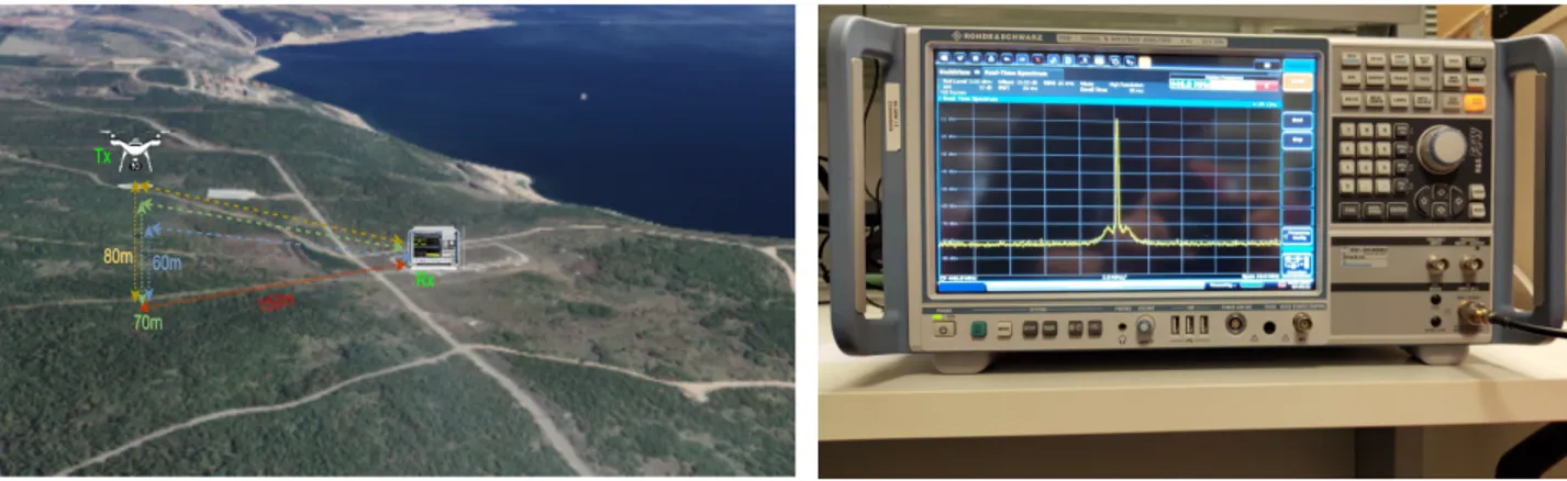
The measurements are taken in the test field which is shown in Fig. 1(a) of The Scientific and Technological Research Council of Turkey (TUBITAK) in Gebze. A narrow band signal generator is used to transmit a single tone in 446MHz center frequency on the UAV side. DJI Wind 4 is flied up to obtain measurement and it is used as a air station since its payload capability and durability in extreme conditions. It is shown in Fig. 1(a).
On the other hand, R&S FSW Signal and Spectrum Ana-lyzer in Fig. 1(b), is used as a ground station to receive the transmitting signals. It works in frequency range from 2Hz to 26.5GHz and offers up to 500MHz analysis bandwidth for measuring wideband–modulated or frequency–agile signals. Signals are sampled by 1MHz and they are recorded with 1sn duration. Furthermore, a Bowtie antenna which frequency range from 400MHz to 1000MHz is used for ground station to receive narrow band signals. The antenna has omnidirectional radiation pattern and it has 0.9dBi antenna gain at 400MHz. After the calculation of received powers of each point, then
(a) Block diagram for measurement setup. (b) Rohde Schwarz FSW26 as receiver. Fig. 1. Measurement campaign and equipment.
path loss model are extracted as it will be explained in Section IV.
B. Measurement Methodology
All the field measurements are conducted in 446 MHz frequency band by using narrow band signal generator attached to a commercial UAV and all the signals are captured by the ground station with 1MHz sample rate during one second. The measurements are collected from 60m to 80m heights with step size 10m vertically. Local regulations allow UAV to operate up to 120m in height, however, due to the to-pographical conditions and the high wind speed after 80m in height, measurements are performend for 60m to 80m in height. Moreover, the only allocated location for UAV flight is, where the measurement is taken, is shown Fig. 1(a) in TUBITAK, Gebze. Also, for each vertical measurement point, UAV move between 50m to 200m horizontally. Overall grid consists of total 45 determined locations points with 60m to 80m vertically and 50m to 200m horizontally. Collected signals are fed into a computer that runs MATLAB 2015b. Raw time data which is given in in–phase/quadrature (I/Q) format are passed through a 255th order FIR filter to maximize power of narrow band signal and to get rid of spurious signals from the captured signal. In addition to this, the center frequency offset is calculated for each point and shifted by that value. Also, another FIR filter with 127th order is used for removing noise arising from harmonics. Furthermore, offset in the time domain, is calculated and eliminated from the processed signal. Then, the signal is down sampled to avoid complexity of the calculation and the average power with dB scale is calculated for each data set.
Measurement campaign workflow for the aforementioned methods is shown Fig. 2.
IV. MEASUREMENTRESULTS
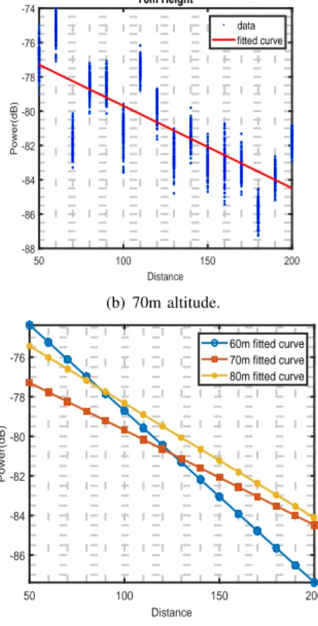
In this study, measurement campaign focuses in the follow-ing aspect on how the narrow band signal received power is related to the transmitter-receiver separation by considering both horizontal and vertical distance. To observe this simul-taneously, Fig. 3 is plotted. As seen in Fig. 3, the received
TABLE I
VALUES FORDmaxANDPATHLOSSEXPONENT, η,FOR446MHZ AT
DIFFERENT ALTITUDES.
Altitude (m) 60 70 80 PL. Exp. (η) 2.176 1.244 1.473
power decreases with the transmitter-receiver separation, as expected. Based on the measurement data when the least-squares estimation is applied, the following path loss models are obtained: PL(dB) = −2.176 × d − 35.99, a = 60m −1.244 × d − 55.23, a = 70m −1.473 × d − 49.4, a = 80m (3)
where d is the transmitter–receiver separation and a stands for the altitude of UAV.
For the sake of brevity, the path loss coefficients for specific frequency and altitudes are listed in Table I. Overall mean path loss exponent is found to be η = 2.176, 1.244, 1.473 for the altitudes of 60m, 70m, and 80m, respectively. Another important observation, which is also in conformity with the results presented in the literature in different frequency [20], is that as the UAV moves up in the horizontal direction, the path loss exponent, η, values decrease in general. Even though, this result looks surprising it is still in parallel with the independent measurement in some other studies in literature [20]. This can be explained as the Tx–Rx communication link will be less sensitive to horizontal distance at high altitude and the channel condition is better in higher altitudes. Furthermore, the UAV at high altitude is most likely be affected less in terms of received power change due to the fact that it flies in the direction of the non–dominant radiation pattern of the BS antenna. Thus, not only environment but also height dependent channel propagation parameters are needed for describing the propagation channel for UAV to ground station communication links.
Environmental Setup DJI Wind 4 + NBSG RS FSW26 SSA + Bowtie Antenna Organization Parameter Settings Post Processing 1. FIR Filter(255th Order) Center Frequency Offset Calibration 2. FIR Filter(127th Order) Time-Domain Offset Calibration Downsampling Average Power(dB) Calculation 1. Order Polynomial Fitting Path Loss Curve Results
Fig. 2. Illustration of the measurement set–up and post–processing workflow.
50 100 150 200 Distance -90 -85 -80 -75 -70 Power(dB) 60m Height data fitted curve (a) 60m altitude. 50 100 150 200 Distance -88 -86 -84 -82 -80 -78 -76 -74 Power(dB) 70m Height data fitted curve (b) 70m altitude. 50 100 150 200 Distance -90 -85 -80 -75 -70 Power(dB) 80m Height data fitted curve (c) 80m altitude. 50 100 150 200 Distance -86 -84 -82 -80 -78 -76 Power(dB) 60m fitted curve 70m fitted curve 80m fitted curve
(d) Comparison of PL curves for different heights.
Fig. 3. Measurement results for received power levels at different distance.
V. CONCLUDINGREMARKS ANDFUTUREDIRECTIONS
In this work, the results of a measurement campaign for air to ground channels of UAV at 446MHz are presented due to the fact that refarming of UHF band will enable new
opportunities for emergency case situations. Based on the measurement data, it is shown that altitude along with the environment is an important factor that needs to be considered. Due to the increase in the elevation, the channel condition gets better and path loss exponent tends to decrease in general.
Thus, in the future studies, we will extend our results to multiple frequency ranges by also incorporating environment affect in different locations and topographies.
ACKNOWLEDGEMENT
This work of Tuncer Baykas was supported by the Scientific and Techno logical Research Council of Turkey (TUBITAK) under Grant 215E324.
Also, this publication was made possible by NPRP12S-0225-190152 from the Qatar National Research Fund (a mem-ber of The Qatar Foundation). The statements made herein are solely the responsibility of the author[s].
REFERENCES
[1] R. Amorim, P. Mogensen, T. Sorensen, I. Z. Kov´acs, and J. Wigard, “Pathloss measurements and modeling for UAVs connected to cellular networks,” in 2017 IEEE 85th Vehicular Technology Conference (VTC Spring). IEEE, 2017, pp. 1–6.
[2] M. Mozaffari, W. Saad, M. Bennis, and M. Debbah, “Drone small cells in the clouds: Design, deployment and performance analysis,” in 2015 IEEE Global Communications Conference (GLOBECOM). IEEE, 2015, pp. 1–6.
[3] H. D. Tu and S. Shimamoto, “A proposal of wide-band air-to-ground communication at airports employing 5-GHz band,” in 2009 IEEE Wireless Communications and Networking Conference. IEEE, 2009, pp. 1–6.
[4] A. Al-Hourani and K. Gomez, “Modeling cellular-to-UAV path-loss for suburban environments,” IEEE Wireless Communications Letters, vol. 7, no. 1, pp. 82–85, 2017.
[5] E. Yanmaz, R. Kuschnig, and C. Bettstetter, “Channel measurements over 802.11 a-based UAV-to-ground links,” in 2011 IEEE GLOBECOM Workshops (GC Wkshps). IEEE, 2011, pp. 1280–1284.
[6] Q. Feng, J. McGeehan, E. K. Tameh, and A. R. Nix, “Path loss models for air-to-ground radio channels in urban environments,” in 2006 IEEE 63rd vehicular technology conference, vol. 6. IEEE, 2006, pp. 2901– 2905.
[7] Q. Feng, E. K. Tameh, A. R. Nix, and J. McGeehan, “Wlcp2-06: Mod-elling the likelihood of line-of-sight for air-to-ground radio propagation in urban environments,” in IEEE Globecom 2006. IEEE, 2006, pp. 1–5.
[8] I. Bor-Yaliniz, S. S. Szyszkowicz, and H. Yanikomeroglu, “Environment-aware drone-base-station placements in modern metropolitans,” IEEE Wireless Communications Letters, vol. 7, no. 3, pp. 372–375, 2017. [9] M. Weiner, “Use of the longley-rice and johnson-gierhart tropospheric
radio propagation programs: 0.02-20 GHz,” IEEE Journal on Selected Areas in Communications, vol. 4, no. 2, pp. 297–307, 1986.
[10] J. Holis and P. Pechac, “Elevation dependent shadowing model for mobile communications via high altitude platforms in built-up areas,” IEEE Transactions on Antennas and Propagation, vol. 56, no. 4, pp. 1078–1084, 2008.
[11] L. Zeng, X. Cheng, C.-X. Wang, and X. Yin, “Second order statistics of non-isotropic UAV ricean fading channels,” in 2017 IEEE 86th Vehicular Technology Conference (VTC-Fall). IEEE, 2017, pp. 1–5.
[12] E. Vinogradov, H. Sallouha, S. D. Bast, M. M. Azari, and S. Pollin, “Tutorial on UAV: A blue sky view on wireless communication,” CoRR, vol. abs/1901.02306, 2019. [Online]. Available: http://arxiv.org/abs/1901.02306
[13] M. Simunek, F. P. Font´an, and P. Pechac, “The UAV low elevation propagation channel in urban areas: Statistical analysis and time-series generator,” IEEE Transactions on Antennas and Propagation, vol. 61, no. 7, pp. 3850–3858, 2013.
[14] A. Al-Hourani, S. Kandeepan, and S. Lardner, “Optimal lap altitude for maximum coverage,” IEEE Wireless Communications Letters, vol. 3, no. 6, pp. 569–572, 2014.
[15] A. Al-Hourani, S. Kandeepan, and A. Jamalipour, “Modeling air-to-ground path loss for low altitude platforms in urban environments,” in 2014 IEEE global communications conference. IEEE, 2014, pp. 2898– 2904.
[16] O. Erem, “stanbul’da 5,8 byklnde deprem,” BBC, 2019. [Online]. Available: https://www.bbc.com/turkce/live/haberler-turkiye-49836320 [17] E. Report, “ECC Report: Harmonised conditions and spectrum
bands for the implementation of future European Broadband Pub-lic Protection and Disaster Relief (BB-PPDR) systems,” Avail-able: https://www.ecodocdb.dk/download/bf3fb2b0-9509/ECCREP218. PDF, Accessed: Oct. 29, 2019.
[18] D. del Rey Carri´on, L. Juan-Ll´acer, and J.-V. Rodr´ıguez, “Radio planning considerations in tetra to lte migration for ppdr systems: A radioelectric coverage case study,” Applied Sciences, vol. 9, no. 2, p. 250, 2019. [19] A. Sanchoyerto, R. Solozabal, B. Blanco, and F. Liberal, “Analysis of
the impact of the evolution toward 5G architectures on mission critical push-to-talk services,” IEEE Access, vol. 7, pp. 115 052–115 061, 2019. [20] X. Cai, J. Rodr´ıguez-Pi˜neiro, X. Yin, N. Wang, B. Ai, G. F. Pedersen, and A. P. Yuste, “An empirical air-to-ground channel model based on passive measurements in lte,” IEEE Transactions on Vehicular Technology, vol. 68, no. 2, pp. 1140–1154, 2018.