Assessment of mining impacts on environment
in Mu
ğla-Aydın (SW Turkey) using Landsat and Google
Earth imagery
Murat Gül &Kemal Zorlu&Muratcan Gül
Received: 7 March 2019 / Accepted: 8 September 2019 # Springer Nature Switzerland AG 2019
Abstract Mining activities are important for the country’s economy, but they cause serious threats to the environment. The geology of SW Turkey comprises Southern (Çine) Submassif of Menderes Metamorphic Massif and the Lycian Nappes. These geological units are unconformably overlain by lignite-bearing Miocene deposits, Upper Miocene–Pliocene conglomerates and Quaternary alluvial deposits. The aim of this study is to determine the geospatial change of mining activities in the Muğla-Aydın provinces, SW Turkey. For this pur-pose, Landsat-5 TM, Landsat-7 ETM, Landsat-8 OLI and Google Earth satellite image data for 1984, 1994, 2004, 2014 and 2018 have been used for change detec-tion analysis. In 1984, only a Miocene lignite quarry was excavated. Then, in 1994, operations for the exca-vation of feldspar–quartz and marble quarries were started, and from 2004 to 2014, mining activities signif-icantly accelerated. An aerial image of 2018 shows that an area of about 3800 ha has been exploited by mining
at 149 quarries. Considering access roads to quarries, plants and dam reservoirs, the human impact extends over 3800 ha. The study area is home to several archae-ological sites and endemic biota. Thus, there is an urgent need for the relocation and protection of archaeological heritages and endemic biota by creating special zones. Additionally, the rich geomorphologic features in the study area that require millions of years to form are at risk of totally disappearing.
Keywords Change detection . Landsat . Geomorphological formation . Environmental conservation . Muğla-Aydın . SW Turkey
Introduction
The awareness for the conservation and protection of the environment has increased in both national and interna-tional spheres. The systematic preservation of all special components (flora, fauna, ancient ruins etc.) of the en-vironment and the transfer of these natural and cultural heritages to future generations are of vital importance. Moreover, the preservation of geomorphological occur-rences that require millions of years to form is an im-portant part of earth sciences (Gül and Uslular2017).
Civilization, urbanization and the increasing popula-tion bring a more demand to raw materials for house-building, cars, telephones, computers, household appli-ances, etc., which are indispensable for our everyday life. Their production requires geo-materials and minerals including iron, copper, zinc and lead. In addition, the https://doi.org/10.1007/s10661-019-7807-3
M. Gül (*)
Department of Geological Engineering, Muğla Sıtkı Koçman University, Kötekli-Menteşe, 48100 Muğla, Turkey e-mail: [email protected]
e-mail: [email protected] K. Zorlu
Kahta Vocational School, Department of Architecture and City Planning, Adıyaman University, Adıyaman, Turkey
M. Gül
Yönelt College, Menteşe, 48000 Muğla, Turkey
/ Published online: 19 October 2019
Check for updates
majority of energy still needed to sustain life is obtained from fossil fuels. Therefore, we need efficient mining in today’s world for sustainable surviving. Mining is defined as a way of extracting geo-materials from the earth’s crust (Mossa and James2013). Mining activities, whether large or small, require the removal of material from the earth’s crust, which results in degradation of the environment in various ways through excavation, transportation or accu-mulation (Szczepanska and Twardowska 1999; Mossa and James 2013; Boengiu et al. 2016; Moeletsi and Tesfamichael 2018; Pericak et al. 2018; Kayet et al. 2019). Though mining has an important role for the economy of country, its areal distribution and regional impacts on socio-environment are not well known (Lobo et al.2018). Modern mining techniques and heavy equip-ment cause dramatic irrevocable alterations in land cover. Some of these alterations due to quarries are the removal of vegetation, blasting, waste disposal and slope modifi-cation, which make mine regions vulnerable to geohazard (Mossa and James 2013). Airborne particulate matter from mining also cause several health problems (Espitia-Pérez et al.2018). In addition, transportation of metal ores of salts, such as oxides, carbonates or sul-phides, can cause dust which damages plant leaves (Kayet et al. 2019). Mossa and James (2013) reported that, worldwide, an area of up to half a million hectares was affected by mining activities in 1990. Recently, the modified land area is greater than this value. Moreover, heavy metal pollution, water contamination, destruction of aquifer layers and several other negative results have been reported because of mining particularly globally widespread lignite-coal quarries (Szczepanska and Twardowska1999; Boengiu et al.2016). Many countries have strict laws that ask rehabilitation of mining areas as fast as possible immediately after mining is over. How-ever, this rehabilitation–remediation process takes a long time and in developing countries, the monitoring of these processes is not in the required level. Abandoned mines continue to threaten health and environment, such as unsafe open pits, leakages to groundwater (Mhlongo and Amponsah-Dacosta 2016). Environmental activists and local residents are opposed to the destructive effects of mining because the altered environment cannot pro-vide ecosystem services since it cannot be reversed to its original situation.
Several studies have been done to determine the effect of open-pit mining areas (Menegaki and Kaliampakos2006; Chen et al.2015; Menegaki et al. 2015; Yu et al. 2018). Yu et al. (2018) computed the
areal changes of land cover and determined their ecological, environmental and socioeconomic impacts against sustainable development. These studies make use of different visual programs and processes. For example, Menegaki and Kaliampakos (2006) used the ArcView software to extract the topographic alteration index; Chen et al. (2015) used high-resolution topogra-phy obtained from an unmanned aerial vehicle, a digital surface model, structure form motion and the slope local length of auto correlation (SLLAC) method; Menegaki et al. (2015) used chromatic contrast of the field view of a quarry area; Boengiu et al. (2016) used Landsat satel-lite images including vegetation cover index differenti-ation. All of these studies show the spatial change at a few or only one quarry. In addition, they are mostly concerned with production or development and give hardly any attention to the local geomorphology effects of each quarry.
Remote sensing data can provide information on changes of land cover over time, which is essential for environmental monitoring in mining areas as well as for environmental impact assessment due to their broad spectral range, affordable cost and rapid coverage of large areas. The synergistic use of remote sensing and ancillary data form geographical information systems (GIS) database, which can be used to store, process and retrieve environmental data (Charou et al. 2010). Remote sensing may be the sole way of acquiring infor-mation about the effects of remote mining locations in dense forested tracts which might be inaccessible on the ground (Malaviya et al., 2010). The integration of re-mote sensing with GIS can further strengthen the capa-bilities of environmental impact assessment of mining activities at both regional and local scales (Chevrel et al. 2001). Landsat and Google Earth images are widely used to determine land use/land cover (LULC) changes caused by mining activities. Malaviya et al. (2010) used LULC change analysis from 1972, 1992 and 2001 Landsat image data for quantification of land use and land cover changes (1972–2006) and habitat diversity in a mining area in Central India. Kayet et al. (2019) used Hyperion (hyperspectral) and Landsat data for spatial analysis of the vegetation dust cover near the mining site, transportation road, dumps and tailing ponds. Lobo et al. (2018) used Sentinel-2 images with Google Earth and GIS for determining the type, scale and status of mines in the Amazon, Brazil. Pericak et al. (2018) employed Landsat images and the Google Earth engine for developing an open-source model for regularly
updating new surface mining that can be refined to capture mining reclamation in the future. The post-classification comparison method is the most common method used for land use/land cover change detection, which entails the comparison of independently pro-duced classified images (Singh, 1989; Garai and Narayana, 2018). Kekovalı and Kalafat (2014) used Google Earth and Google Maps TruEarth® 15-m imag-ery for visualization and reported that satellite remote sensing can be efficiently used for the detection of mining and quarrying activities in Turkey. Numerous researches on environmental monitoring show that re-mote sensing observations are becoming an important tool for surveying different features at local, regional and global scales (Bochenek et al. 1997; Sunar and Ozkan2001; Fensholt and Sandholt2003; Vijdea et al. 2004; Belward and Skøien2015; Ma et al.2017).
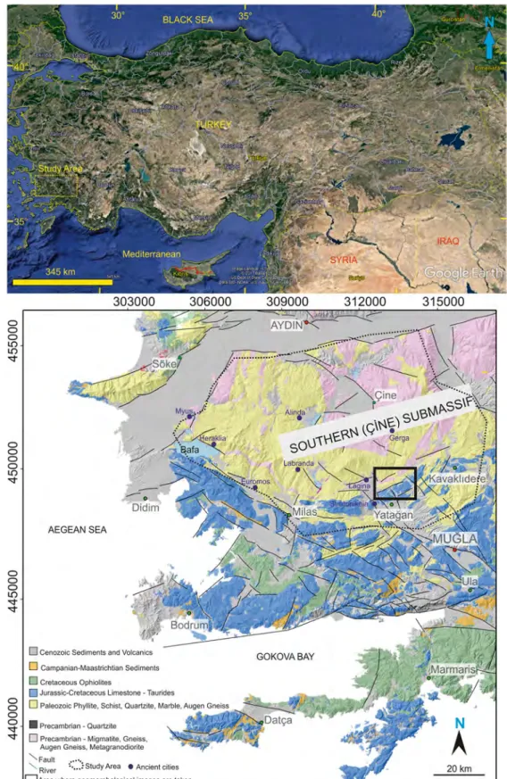
This study was carried out in Milas, Yatağan and Kavaklıdere (Muğla Province) and Çine and Bozdoğan (Aydın Province), towns located in SW Turkey (Fig.1). This region contains core and cover geological units of the Southern (Çine) Submassif of the Menderes Meta-morphic Massif (Okay2001; Özer et al.2001; Whitney and Bozkurt2002). They are tectonically overlain by the Lycian Nappes and unconformably overlain by tertiary units (Okay 2001; Özer et al. 2001; Whitney and Bozkurt2002). The core units of the Southern Massif can be seen along the Yatağan–Çine, the Milas–Söke and the Kavaklıdere–Bozdoğan highways (Alkanoğlu 1984; Oğuz2011; Gül and Uslular2014,2015,2016, 2017; Karaarslan et al.2017). The region is also home to special biota that are under protection (Kahraman and Körbalta2017; Lise2017). The studied area has been a host to various civilizations since ancient times, which attract a quite large number of local and foreign visitors. In addition to these natural and cultural riches, a large number feldspar, quartz and marble quarries are exca-vated in the core of the Southern Submassif and the Lycian Nappes. Lignite quarries are widely distributed in tertiary deposits in the western part of Yatağan town which are used for fuel to Yatağan thermic power plant. These are important income sources both for the local and national economy. While there are few researches on the marble quarry wastes from the region (Bilgin and Koç2013; Altun2014; Güler and Polat2018), several studies have been carried out on geomorphological fea-tures and the area’s potential as a geopark (Alkanoğlu 1984; Oğuz2011; Gül and Uslular2014,2015,2016, 2017; Karaarslan et al. 2017). These studies all
emphasized the negative effects of mining activities. However, none of them mentioned the space- and time-dependent changes related to mining. Thus, this study aimed to determine the total deformed area due to mining activities and analyse the effect of mining on the environment along with the regional geomorphology.
Materials and methods
The study area covered roughly 440,000 ha within the towns of Milas, Yatağan and Kavaklıdere (Muğla) and Çine and Bozdoğan (Aydın). Multi-temporal Landsat data and high-resolution Google Earth data for the years 1984, 1994, 2004, 2014 and 2018 were used to determine the geospatial changes caused by mining (Tables1and2) in the area. Imagery from the Landsat 5 Thematic Mapper (TM) for 1984 and 1994, the Landsat 7 Enhanced The-matic Mapper (ETM) for 2004 and the Landsat 8 Opera-tional Land Imager (OLI) for 2014 and 2018 were acquired from the websitehttps://earthexplorer.usgs.gov/(Table1). The Google Earth imagery data for 1984, 1994, 2004, 2014 and 2018 were acquired from Google Earth software. The initial mining activity was started in the Yatağan region in 1984. Then, the images of 1994, 2004 and 2014 were examined to observe the changes at 10-year intervals. The 2018 images were investigated to assess the magnitude of the quarries spreading using Arcgis, Envi and Google Earth software. The areas and perimeters of 149 quarries (seen white due to the deformed topography and destruction of the forest in the Google Earth images) were determined in the 2018 Google Earth images. The statistical evaluation was made with the Excel software and presented in detail. The types of quarries were determined based on geological maps, previous studies and field trips.
Geological setting
The Menderes Massif is one of the biggest metamorphic complexes that evolved due to the Alpine orogeny (Şengör et al.1984; Bozkurt et al.1995; Whitney and Bozkurt 2002). Southern (Çine) Submassif, which is part of the Menderes Massif, is exposed between the towns of Milas, Yatağan and Kavaklıdere (Muğla) and Çine and Bozdoğan (Aydın) in SW Turkey (Konak et al. 1987; Bozkurt et al.1995; Bozkurt2004; Erdoğan and Güngör2004; Erdoğan et al.2011; Koralay et al.2012; Bozkurt et al.2015; Seyitoğlu and Işık2015). It extends
Fig. 1 Location map of the study area (Google Earth image) including general geological map and the digital elevation model (modified from Okay2001; Özer et al.2001; Whitney and Bozkurt2002; Gül and Uslular2016)
0 0 0 LO LO "SI" 0 0 0 0 LO "SI" 0 0 0 LO "SI" "SI" 0 0 0 AEGEAN SEA
0 Cenozoic Sediments and Volcanics D Campanian-Maaslrichlian Sediments 0 Cretaceous Ophiolites
~
•
Precambrian -Quartzite V O Precambrian• Migmatite, Gneiss,Augen Gneiss, Metagranodiorite
"-Faull •·
River ~·.:.) Study Area • Ancient cities
0 Area where geomorphological images are taken
N
A
to the east. This submassif includes hills of 700–750-m-high hills at the centre and surrounding valleys. Candan et al. (2001) reported that the core part of this submassif contains metasediments, micaschist, orthogneiss, metagabbros and metanorite. This part was mapped as Precambrian quartzite, Precambrian migmatite, gneiss, augen gneiss and metagranodiorite in Fig.1. The core units are overlain by the cover ones, including Palaeozoic phyllite, schist, quartzite and marble (Fig. 1; Okay2001; Özer et al.2001). Bozkurt (2004) defined a leucogranite intrusion (late Middle Eocene; Bozkurt et al.2015) in the rectangular area (Fig.1). The Alpine deformation produced HT/MP Barrovian-type regional metamorphism and greenschist retrograde metamor-phism (Şengör and Yılmaz1981;Şengör et al. 1984; Bozkurt and Satır2000; Bozkurt and Oberhansli2001; Rimmele et al.2003; Bozkurt 2004). Southern move-ment of the Lycian Nappes including the blue-coloured Jurassic–Cretaceous limestone and Cretaceous ophiolite caused the development of metamorphism (Bozkurt 2004). This metamorphism and related geological pro-cesses generated the formation of industrial minerals such as feldspar (albite), quartzite and marble (Kuşçu 1992; Kun et al.1999; Uygun and Gümüşçü2000; Özer et al.2001; Bağcı2006; Yavuz et al.2005,2005a). All
of these units are unconformably overlain by post-Oligocene lignite-bearing deposits, which filled the E– W and NNW–SSE grabens (Atalay1980; Görür et al. 1995; Gürer and Yılmaz2002; Gül2015).
Features of the study area needing preservation and monitoring
The region hosts various remarkable geomorphological formations, several ancient cities and endangered biota. These features are in need of protection for both for present and future generations. This region is evaluated under the term of the Menteşe in the Aegean Region (W Turkey). The most important elevation in this area is the Beşparmak Mountain (1350 m), east of Lake Bafa. The northern and eastern parts of the study area are limited by alluviums of the Büyük Menderes River (Fig.1; active graben). The slopes of the Menteşe Mountains are covered by oak, pine and chestnut forests, and the lower parts are with maquis. Agriculture (including olive, peanut pine etc.) and mining activities (marble, feldspar, lignite, quartzite) are the main sources of income for the local economy (Doğaner2017). Due to the geomorphological occurrences and ancient cities, a geopark was planned to be constructed on an 18 thousand ha area between Yatağan (Muğla) and Çine (Aydın) (Lagina and Stratonikeia; Oğuz2011) which en-compasses a very small area in the south-eastern part of the studied 440 thousand ha large region. The geoparks are evaluated with their geological heritage properties. Be-cause the region provides important information for the evolution of the earth’s crust, such as fossil beds, tectonic structure, earth shape, mineral assemblage and mines, their subsequent visual transfer to future generations is impor-tant (Güngör 2012; Kazancı et al. 2012; http://www. jemirko.org.tr/tanimi/;access date: 22.12.2017).
Table 1 Details of Landsat data used for study
Satellite Sensor Path/row Year Resolution (m)
Landsat TM 180/034 1984 30
Landsat ETM 180/034 1994 30
Landsat ETM 180/034 2004 30
Landsat OLI 180/034 2014 30
Landsat OLI 180/034 2018 30
Table 2 Spatial distribution of mine quarries at 2018 in Muğla-Aydın region (SW Turkey) Quarries between Milas and Çine
(red regions in Fig.6)
Quarries between Yatağan and Çine (yellow regions in Fig.6)
Quarries between Kavaklıdere and Bozdoğan (blue regions in Fig.6)
Number of quarries 47 51 51
Measurements Area (ha) Perimeter (km) Area (ha) Perimeter (km) Area (ha) Perimeter (km)
Average 24.12 2.69 39.00 2.78 13.31 1.52
Maximum 190.00 11.20 909.00 20.00 171.00 10.90
Minimum 1.68 0.53 1.24 0.43 0.41 0.24
Standard deviation 34.91 2.49 128.12 3.31 29.32 1.92
Territorial sum 1133.72 126.26 1988.90 141.57 678.60 77.32
Geomorphological occurrences
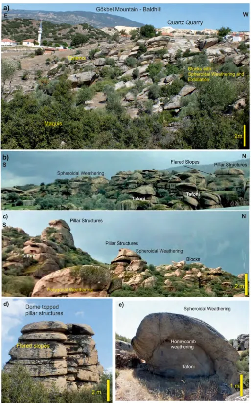
These occurrences are visually observed along the Yatağan–Çine highway. The bald hill, domes and pillar features with a flat top were classified as large-scale structures, whereas the weathering pits, polygonal cracks, tafoni, honeycombs, corestones, blocks, sphe-roidal weathering, exfoliation structures and flared slopes were defined as small-scale geomorphological features (Fig. 2; Gül and Uslular 2014, 2015, 2016, 2017). The structural properties, mineral alignment–fo-liation, mineral strength differences (quartz versus feld-spar), climate condition, subsurface weathering, exhu-mation and weathering period were determined as the main controlling factors (Gül and Uslular2014,2015, 2016,2017). An exhumation, metamorphism of rocks and mineral alignments, goes back to at least the Mio-cene (Gürer and Yılmaz2002; Bozkurt2004; Koralay et al.2012). These large- and small-scale geomorpho-logical occurrences exhibit an interesting scenery for geotourism and when combined with historical sites and endangered flora and fauna all add great value to the cultural tourism and ecotourism. Recently, however, it was revealed that they are threaten by dense mining activities (Gül and Uslular 2014, 2015, 2016, 2017; Karaarslan et al. 2017). Thus, at least the special and unique natural and cultural features must be protected both for present and future generations.
Flora and fauna
Olive orchards, maquis, frigana bushes and forests of Pinus brutia, Quercus coccifera and Pinus pinea have been observed in the study area (Kahraman and Körbalta2017; Lise2017). It is reported that this region is home to rare and endangered flora Cycla-men mirabile, Arenaria cariensis, Silene splendens and Liquidambar orientalis and fauna including the Caria lizard (Lise 2017). These have great impor-tance in terms of the ecotourism potential of the study area. At the same time, they also positively promote cultural tourism and geotourism. Moreover, olive trees, Pinus pinea and Liquidambar orientalis have an economic importance for the local villagers. Some parts of the study area are preserved under legislation as a natural site (Kahraman and Körbalta 2017), but they are still under pressure from expanding mining activities.
Historical sites
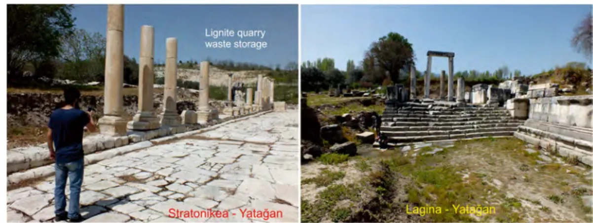
Information obtained from the web pages of the Cul-ture and Tourism Ministry of the Turkish Republic (http://www.aydinkulturturizm.gov.tr/TR,64399 / m u z e l e r - v e - o r e n y e r l e r i . h t m l : a c c e s s d a t e : 05.12.2017; http://www.muglakulturturizm.gov. tr/TR,157773/muzeler-ve-bagli-oren-yerleri.html: access date: 05.12.2017) revealed that this region hosts several ancient cities namely Stratonikeia and Lagina in Yatağan town; Labranda, Euromos, Latmos, Myus and Herakleia in Milas town; Alinda and Gerga in Çine town; and Köreteke Castle in Bozdoğan town dates back to 4000 years (Fig. 1). Most of those cities are also under pressure from expanding mining activities. For example, the largest lignite-mining quarry extends between the ancient cities of Stratonikeia and Lagina (Figs. 1 and 3). Stratonikeia also contains remnants belonging to the Anatolian Seljuk State (eleventh century), the Period of Emirates (twelfth Century) and the Ottoman Em-pire (until the beginning of 1900s) and operated until the early of the Turkish Republic (twentieth century) (Söğüt2015). If these potential attractions are evalu-ated in geotourism and ecotourism manner, this re-gion may become a new tourism centre.
Digital image analysis and geospatial change of mining activities
The Landsat and Google Earth images were used for analysing the geospatial change of the mining activities in the area. Google Earth images with 0.50-m resolution and Landsat images with 30-m resolution were used for digitizing. The subset process was performed on the Landsat and Google Earth images to extract the study area by taking geo-referenced outline boundaries. The visual interpretation method was used for the Google Earth images and the unsupervised classification was employed for the Landsat images. The boundaries of potential mining areas were manually digitized from the Google Earth images from 1984, 1994, 2004, 2014 and 2018 using the visual interpretation method. First, the Landsat images of the study area were calibrated geo-metrically and radiogeo-metrically, followed by the unsuper-vised classification. The boundaries of potential mining areas were digitized from the classified Landsat images for 1984, 1994, 2004, 2014 and 2018. The digitized potential mining areas from the images were verified
Fig. 2 Special geomorphological occurrences of the study area. (a) Gökbel Mountain (reported as bald hill by Gül and Uslular (2016)) in SE of the study area is surrounded by the valley. A quartz quarry is active SE of Gökbel Mountain. (b) Skirt of Gökbel Mountain contains various sized pillar structures with small-scale
features. (c) Spheroidal weathering, polygonal weathering and tafoni structures were observed in and on the pillar structures. (d) Spheroidal weathering led to development of the dome-topped structures with flared slopes. (e) Honeycomb weathering can be observed inside the tafoni
via ground control points (GCP) which were obtained from field trips. The mining areas obtained from the Landsat and Google Earth images were then finally combined for calculating the annual exploited mining area (Fig. 4). Enhancement techniques like contrast stretching, histogram adjustment, filtering and changes in band combinations were applied when interpreting the dataset. To understand the changes in the study area due to mining activities, change detection was per-formed on the Landsat 5 TM image from 1984 and the Landsat 8 OLI image from 2018.
The satellite images were analysed in detail, where forestry areas are shown in green colour, lakes, rivers and sea areas are in dark blue and rocky areas are in red, dark pink and brown tones depending on the rock types. The areas used as flatland and agricultural areas are generally seen in light green tones with regular bound-aries. The mining activity areas can be easily distin-guished from other areas as white coloured, smooth geometric areas due to the breakage of rocks (Figs.5, 6and7). Their depths vary between 0 and 200–300 m. The images from 1984–1994–2004–2014 were used to Fig. 4 Flowchart of data analysis
Fig. 3 The ancient cities of Stratonikeia and Lagina are located very close to the Yatağan lignite quarry
DATA COLLECTION
LANDSAT IMAGES
SUBSET (study area)
PREPROCESSING (Radiometric and geometric
calllbration) UNSUPERVISED CLASSIFICATION CHANGE DETECTION (1984-2018) GOOGLE-EARTH IMAGES VISIUAL INTERPRETATION (Digitize potential mining.areas)
VERIFICATION
{Using GCP derivled from field trips)
COMBINING (Landsat and Google-Earth
images combined and calculated quarry areas)
Fig. 5 (a–a′) The only mining activity is in the Yatağan lignite quarry (purple arrow). (a) 1984 Landsat 5 TM. (a′) Google Earth images. (b–b′) The lignite quarry was enlarging (purple arrow) and the feldspar–quartzite quarries started operation north of Milas (red arrow). (b) 1994 Landsat 7 ETM. (b′) Google Earth images. The Geyikli Dam Lake appeared between the Milas town and Gökbel Mountain. (c–c′) The lignite quarry continued to expand (purple arrow) and feldspar–quartzite quarries were observed NNW of Milas town (red arrow), and marble quarries were found
between Milas and Yatağan and Kavaklıdere towns (green ar-rows). (c) 2004 Landsat 7 ETM. (c′) Google Earth images. (d–d′) The lignite quarry was continuing to expand to the north (purple arrow) and feldspar–quartzite quarries increased NNW of Milas town (red arrow) and west of Lake Bafa, and the marble quarries increased between Milas and Yatağan and Kavaklıdere towns (green arrows). (d) 2014 Landsat 8 OLI. (d′) Google Earth images. In addition, Çine Dam Lake appeared west of Gökbel Mountain
express 10 years of visual change, while the 2018 im-ages were used for a recent view and to determine the spatial distribution of mining activities.
The images from 1984 revealed the only significant mining activity at the lignite quarry in the western part of the town of Yatağan, which is near the ancient city of Fig. 6 (a) Google Earth and (b) Landsat 8 OLI views of the study
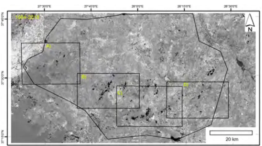
site in 2018. Three different regions were defined based on geo-graphical provinces and dominant quarry types. The Kavaklıdere region (blue) includes marble quarries. The region among the Çine town, Milas town, Lake Bafa and Beşparmak Mountain (red)
contains feldspar–quartzite quarries. The largest yellow area be-tween the ancient cities of Stratonikeia and Lagina is a lignite quarry; yellow regions north of this are feldspar–quartzite quarries; the remaining yellow regions are marble quarries. Detailed 2018 views (a, b, c, d) (rectangular areas) are presented in Fig.7
27'30'0"E 27•45'Q"E 28'0'0"E 28'15'0"E 28•:JO'O"E
Stratonikeia. Apart from this, no mining activity was observed in the study area. The lignite deposits have been used in the Yatağan Thermic Power Plant which is located between the quarry and the town of Yatağan (Fig.5(a–a′)).
After 10 years, the mining at the lignite quarry in the Yatağan region was expanded (Fig.5(a–a′, b–b′)). With detailed examination, small white spots were detected near Yatağan centre that indicate marble quarries and spots around the ancient city of Labranda in the northern part of the town of Milas indicate feldspar–quartz
quarrying activities (Fig. 5(b–b′)). In this period, the Geyikli Dam Lake appeared between the town of Milas and Gökbel Mountain, which is another anthropogenic impact observed in the 1994 image (Fig.5(b–b′)).
The mining activities have increased considerably during the 10-year period after 1994 (Fig.5(c–c′)). It is clearly observed that all the mining fields that have been operating since 1994 have boosted. In addition to these, new feldspar–quartzite quarries started to operate be-tween the towns of Çine and Milas and bebe-tween Yatağan and Çine (Fig. 5(c–c′)) along with. Numerous marble Fig. 7 Detailed Landsat 8 OLI images (a, b, c, d) and Google
Earth views (a′, b′, c′, d′) of the study region in 2018. (a–a′) View of bare topography and view with quarries boundary north of Milas town. (b–b′) View of bare topography and view with
quarries boundary east of Milas town. (c–c′) View of bare topog-raphy and view with quarries boundary west of Yatağan town. (d– d′) View of bare topography and view with quarries boundary of Kavaklıdere town
quarries were operating between Yatağan and Milas and around the town of Kavaklıdere (Fig.5(c–c′)).
The spatial distribution of the mining activities has doubled in 10 years after 2004 (Fig. 5(d–d′)). This significant increase can be viewed through the feldspar–quartzite quarries in the region, which are lo-cated between Yatağan, Milas and Çine (Fig.5(d–d′)). A similar expansion is also valid for the marble quarries between Yatağan and Milas and around Kavaklıdere (Fig.5(d–d′)). In addition to the growth of these existing minefields, new feldspar–quartzite–marble quarries were also started operating (Fig. 5(d–d′)). The Çine Dam Lake appeared in the 2014 Google Earth image in the southern part of the town of Çine (Fig.5(d–d′)).
The Landsat 8 OLI and Google Earth images from 2018 were used to determine the quarry areas in differ-ent regions. These areas cover roughly 440,000 ha and are spread to the towns of Milas, Yatağan and Kavaklıdere (Muğla) and Çine and Bozdoğan (Aydın). Three different regions were examined based on the geographical province boundaries and dominant types of mining activities (Fig.6; Table2).
The areas marked in red between Milas, Lake Bafa, Beşparmak Mountain and Çine are feldspar and quartz-ite quarries (Figs.6and7). They started operation after 1994 (Fig. 5(b–b′)). A total of 47 large and small feldspars–quartzite quarries were determined. They vary in size between 1.68 and 190 ha and have a total area of 1133.72 ha (Figs.6 and 7; Table2). The presence of unmarked, small-scale quarries and numerous wind farms built after 2014 (not marked) indicate that the human intervention is greater than the measured value (Figs.6and7; Table2).
The sizes of the 51 quarries between Yatağan and Çine, marked in yellow, are between 1.24 and 909 ha and sum up to 1988.90 ha. The largest one with 909 ha is a lignite quarry between the ancient cities of Lagina and Stratonikeia (Figs.6and7). Some sites have been rehabilitated with olive trees by enterprises. Twelve quarries in the northern part of the lignite area were evaluated as feldspar–quartzite quarries, covering a total of 366.73 ha which vary from 3.96 to 102 ha. Roughly 717.13 ha in this region are located in the western part of the lignite areas which are covered by the units of the Southern Submassif and the Lycian Nappes limestone and were evaluated as marble quarries (Figs.6and7).
The areas marked in blue are in the vicinity of Kavaklıdere, between Kavaklıdere and Bozdoğan, and mainly indicate marble quarries excavated in cover units
of the Southern Massif and Lycian Nappes limestone. The size of the 51 marked quarries varies from 0.41 to 171 ha, and they cover a total area of 678.70 ha (Figs.6 and7; Table2).
In this study, 149 quarries were taken into consider-ation. Their total size was determined as 3801.22 ha, of which 909 ha are lignite quarries. Roughly 1500 ha are feldspar–quartzite quarries and are located near the towns of Milas, Yatağan and Çine and Lake Bafa, while 1391.8 ha are marble quarries between Milas and Yatağan, and around Kavaklıdere (Figs. 6 and 7; Table2).
The mining activities have irreversibly destroyed roughly 3800 ha of the 440,000 ha study area’s mor-phology. The effects of these mining activities are evi-dently seen from the change detection image (Fig. 8). The black-coloured areas in Fig.8show the most dam-aged spots by mining activities from 1984 to 2018 (Fig. 8). In addition to the mining activities, the dam lake, wind farms, road constructions for the quarry areas and numerous small quarries have not been calculated in this study. As well as the local geomorphology, these also have an adverse anthropogenic impact on the environ-ment. For example, the size of the Çine Dam Lake south of Çine is 163 ha, while the Geyikli Dam Lake in the southern part of the ancient city of Labranda covers 217 ha. The irreversible destruction of the morphology is evident over more than in 4000 ha. Most of those changes have occurred in a very short time, precisely after 2004. Mining activities and related infrastructure including electricity and transportation networks may increase the destruction of the morphology and cause further environmental damage in the near future.
Evaluation in terms of environmental impact
Within the scope of this study, geospatial changes of mining in the region among the towns of Çine, Bozdoğan (Aydın), Milas, Yatağan and Kavaklıdere (Muğla) in SW Turkey were investigated (Figs.1,2,3, 4,5,6,7,8and9). Feldspar and quartz quarries have been opened in the metamorphic rocks of the Southern (Çine) Submassif and marble quarries have been exca-vated in cover units of the Southern (Çine) Submassif and the Lycian Nappes (Figs.1,7and9). The largest lignite quarry (909 ha) is operated in tertiary cover of these units (Figs.1,7,9,10and11).
Large feldspar–quartz quarries have deformed a 1500-ha land in the central and southern parts and the
cover of the Southern (Çine) Submassif (Figs.1,6,7 and8(d)). In addition to the morphological disturbance, particulate matter, noise and surface contamination are other negative effects originated from these quarries. A 18,000 ha of the SE part of this region, planned as a geopark, contains important geomorphologic occur-rences (Alkanoğlu1984; Oğuz2011; Gül and Uslular 2014, 2015,2016,2017; Karaarslan et al.2017). The geopark region and the rest of the massif contain endan-gered species of flora and fauna and many historical
sites. If they are evaluated together, this region has great potential in terms of biotourism, ecotourism, geotourism and cultural tourism.
The marble quarries have deformed a 1390-ha area in the southern cover part of the Southern (Çine) Submassif and the Lycian Nappes (Figs.1,6,7and9). This part is also home to endangered flora and fauna species and many historical sites. In addition to the morphological disturbance, wastes have increased at quarries and rock processing plants during the marble Fig. 8 Changes of mining areas
from 1984 to 2018 with using the Landsat images (black areas greatly changed). Detailed 2018 views (a, b, c, d) (rectangular areas) are presented in Fig.7
Fig. 9 (a) Field view of the marble quarry that includes 5–8-m steps. (b) Randomly dispersed marble waste including palladian, marble dust and blocks caused visual contamination. (c) Various sized residual material can be form during the mining operations;
the blocks is one of coarser residual material. (d) Grinding of the marble led to finer-grained product that can be used in thermic power plant, cement industry etc. They cause visual contamination and air pollution
excavation process. For example, wastes that have in-creased during marble mining are debris, palladian, marble slurry and marble dust (Bilgin and Koç 2013;
Altun2014; Gül2015a). These wastes cause vegetation loss, noise and visual pollution (Fig. 9), surface and ground water contamination, soil contamination and Fig. 10 (a) General view of the
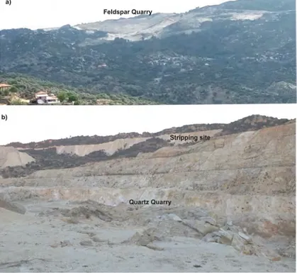
feldspar–quartz quarry. They de-form the square kilometres re-gion. (b) The mining operation contains 5–8-m bench, clean raw material transported to the plant and contaminated part is poured to the stripping site. They also deform the recent morphology and cause visual contamination and air pollution
Fig. 11 (a) General view of the lignite quarry that includes 5–8-m steps. It has deformed all tertiary units west of Yatağan. Lignite transported to the thermic power plant via trucks or kilometres long conveyor belt. (b) Cover units on lignite have been excavated
and transported to the stripping site. They also deform the recent morphology. (c) In west of Yatağan town, marble and lignite quarries operate close to each other. (d) Small ponding evolves during the lignite operation
atmospheric pollution (Bilgin and Koç 2013; Rajgor et al. 2013). Similar environmentally adverse effect can be observed in the Menderes Massif feldspar– quartzite quarries (Fig.10).
Roughly 900 ha of the lignite-bearing tertiary units in the Yatağan region have been deformed by the lignite quarry (Figs. 1, 6, 7 and 11). Coal-mining has been reported as a major geomorphic activity in the USA (Mossa and James 2013). The change of the original profile also results in potential instabilities (Boengiu et al.2016). Waste from coal-mining has caused water deterioration due to leaching (Szczepanska and Twardowska1999). The use of low calorific value lig-nite in the Yatağan Thermic Power Plant has led to a great quantity of waste, which was deposited in waste disposal after long transportation (Baba 2001, 2003; Baba et al.2003). This lignite waste, after combustion, has caused the ground water contamination (Baba 2001). This happens through water mixing with the alluvial aquifer (Baba2001) and water use in agricul-ture. All of these negative effects add to the undesirable outcomes due to mining in terms of environmental issues. Recent enterprise planning in underground min-ing in the Yatağan region (Güney and Gül,2018) caused potential subsidence, which is another adverse effect on the regional geomorphology. The deformed part has been partially rehabilitated, mostly through the planting of olive trees by a previous state company and later a private enterprise.
Mhlongo and Amponsah-Dacosta (2016) reported the detrimental effects of abandoned mining in terms of health, safety, environmental stress and social effects in South Africa. Thus, similar effects will mostly likely to be soon seen in the study area.
Destruction of the local geomorphology, visual pol-lution, noise–dust–particulate matter, destruction of the forestry area and soil–water–atmospheric contamination are all threatening the morphology, ancient cities, flora and fauna and tourism activities which are closely relat-ed to these assets. Although moving ancient ruins to safe places, and keeping flora and fauna alive in favourable conditions can be undertaken, these activities are impos-sible, for geomorphological formations when they are lost. They must be protected from mining and other negative disturbances. In addition to the protection of endangered biota, local protection sites for archaeolog-ical ruins and the geopark proposal (previously reported by Oğuz, 2011) in the study area must be realized immediately by local beneficiaries and government
agencies for the protection of those geomorphological occurrences.
Mining should be initiated carefully considering the environmental impact (Mossa and James 2013). From 1984 to the present day, the geospatial increase of min-ing areas clearly shows the importance of minmin-ing in terms of the local economy. Thus, abandoning them in the near future is inappropriate as they are essential for local income and energy production. The mining activ-ities in the study area are mostly intended to extract the most profitable part of the mine (wild mining), except a few good examples. In total, 3800 ha has already been lost. Moreover, if we take into consideration also the road access to quarry areas, dam reservoirs and other human construction, the destroyed area is greater than calculated 3800 ha. Thus, local governments (governor-ships, district governors, municipalities), mining com-panies and universities should urgently cooperate for more environmentally friendly mining. Once specific mining areas have been identified, integrated and inno-vative management plans should be developed, includ-ing access, development and promotion of these areas. Cultural tourism facilities such as geoparks should be implemented as an alternative income source for the local economy. Cultural tourism facilities should be constructed by taking into account the geomorphologi-cal characteristics of the region, its archaeologigeomorphologi-cal and historical significance, and the biota.
Conclusion
Landsat with 30-m and Google Earth with 0.5-m reso-lution images have been used for detecting the impacts of mining on the environment in the provinces of Muğla and Aydın (Turkey). The study shows the increasing trend of land cover changes caused by mining activities over the last 34 years. The combination of the low-resolution multispectral Landsat images and the high-resolution Google Earth images provides a highly con-venient means of defining the boundaries of quarries. From 1984 to 2018 (especially the last 14 years), mining activities have increased between the towns of Yatağan, Milas and Kavaklıdere (Muğla) and Çine and Bozdoğan (Aydın) in SW Turkey. A total of 3800 ha out of the 440,000 ha has been demolished due to the mining activities. 1500 ha has been destroyed by feldspar– quartzite quarries, 1390 ha by marble quarries and 900 ha by the lignite quarry. All of these threaten the
region by destroying ancient cities as well as the prov-ince’s flora and fauna. In addition, the feldspar–quartz quarries have been demolishing large- and small-scale geomorphological occurrences. The increasing mining activities in this region revealed the importance of min-ing for the local and national economy. But necessary precautions for the protection of the special features of the studied region must be taken into immediate consid-eration for preserving natural and cultural heritages for present and future generations.
Acknowledgements The authors thank to anonymous reviewers and editors for their valuable contribution for increasing the sci-entific quality of the paper. The authors thank to Dr. Iliya Bauchi Danladi and Dr. Erhan Akça for their editorial help.
References
Alkanoğlu, E. (1984). Menderes masifindeki tafoniler. Yeryuvarı veİnsan, 8-4, 11–13 (in Turkish).
Altun, N. E. (2014). Assessment of marble waste utilization as an alternative sorbent to limestone for SO2 control. Fuel Processing Technology, 128, 461–470.
Atalay, Z. (1980). Muğla-Yatağan ve yakın dolayı karasal Neojen’inin stratigrafi araştırması. Türkiye Jeoloji Kurumu Bülteni, 23, 93–99 (in Turkish with English abstract). Baba, A. (2001). Yatağan (Muğla) Termik Santralı Atık Depolama
Sahasının Yeraltı Sularına Etkisi. Jeoloji Mühendisliği Dergisi, 25-2, 1–19 (in Turkish with English abstract). Baba, A. (2003). Geochemical assessment of environmental
ef-fects of ash from Yatagan (Mugla- Turkey) thermal power plant. Water, Air, & Soil Pollution, 144, 3–18.
Baba, A., Kaya, A., & Birsoy, Y. (2003). The effect of Yatagan thermal power plant (Mugla–Turkey) on the quality of surface and ground waters. Water, Air, & Soil Pollution, 149, 93–111. Bağcı, M. (2006). Kozağaç-Kalınağıl (Muğla) Mermerlerinin
Jeolojisi, Teknik Analizi ve Maden EkonomisiAçısından Değerlendirilmesi. PhD Thesis, Süleyman Demirel University, Physical and Applied Science Institute, Isparta, 241 p (unpublished).
Belward, A. S., & Skøien, J. O. (2015). Who launched what, when and why; trends in global land-cover observation capacity from civilian earth observation satellites. ISPRS Journal of Photogrammetry and Remote Sensing, 103, 115–128. Bilgin, Ö., & Koç, E. (2013). Mermer Madenciliğinde Çevresel
Etkiler (Environmental Impacts in Marble Mining). Madencilik Türkiye, 68–79 (in Turkish).
Bochenek, Z., Ciolkosz, A., & Iracka, M. (1997). Deterioration of forests in the Sudety mountains, Poland, detected on satellite images. Environmental Pollution, 98(3), 375–379. Boengiu, S., Ionuş, O., & Marinescu, E. (2016). Man-made
chang-es of the relief due to the mining activitichang-es within Husnicioara open pit (Mehedinţi County, Romania). International Conference – Environment at a Crossroads: SMART ap-proaches for a sustainable Future. Procedia Environmental Sciences, 32, 256–263.
Bozkurt, E. (2004). Granitoid rocks of the southern Menderes Massif (southwestern Turkey): field evidence for Tertiary magmatism in an extensional shear zone. International Journal of Earth Sciences, 93, 52–71.
Bozkurt, E., & Oberhansli, R. (2001). Menderes Massif (western Turkey): structural, metamorphic and magmatic evolution—a synthesis. International Journal of Earth Sciences, 89, 679–882. Bozkurt, E., & Satır, M. (2000). New Rb-Sr geochronology from southern Menderes Massif (southwestern Turkey) and its tectonic signifance. Geological Journal, 35, 285–296. Bozkurt, E., Winchester, J. A., & Park, R. G. (1995).
Geochemistry and tectonic significance of augen gneisses from the southern Menderes Massif (West Turkey). Geological Magazine, 132, 287–301.
Bozkurt, E., Ruffet, G., & Crowley, Q. G. (2015). Güney Menderes Masifi’nde Sinorojenik Eosen Lökogranit Magmatizması ve Tektonik Önemiv (Synorogenic Eocene Leucogranite Magmatism In The Southern Menderes Massif And Its Tectonic Significance). 68. Türkiye Jeoloji Kurultayı Bildiri Özleri kitabı (Proceedings of 68th Turkish Geologic Congress), 06-10 Nisan 2015 MTA-Ankara-Turkey, 50-51 (in Turkish with English abstract)
Candan, O., Dora, Ö., Oberhansli, R., Çetinkaplan, M., Partzsch, J. H., Warkus, F. C., & Dürr, S. (2001). Pan-African high-pressure metamorphism in the Precambrian basement of the Menderes Massif, western Anatolia, Turkey. International Journal of Earth Sciences, 89, 793–811.
Charou, E., Stefouli, M., Dimitrakopoulos, D., Vasiliou, E., & Mavrantza, O. D. (2010). Using remote sensing to assess impact of mining activities on land and water resources. Mine Water and the Environment, 29, 45–52.https://doi.
org/10.1007/s10230-010-0098-0.
Chen, J., Li, K., Chang, K. J., Sofia, G., & Tarolli, P. (2015). Open-pit mining geomorphic feature characterisation. International Journal of Applied Earth Observation and Geoinformation, 42, 76–86.
Chevrel, S., Kuosmannen, V., Belocky, R., Marsh, S., Tapani, T., Mollat, H., et al. (2001). Hyperspectral airborne imagery for mapping mining related contaminated areas in various European environments—first results of MINEO project. In 5th international airborne remote sensing conference, San Francisco, California, 17th–20th September.http://citeseerx. ist.psu.edu/viewdoc/download?doi=10.1.1.584.5697&rep= rep1&type=pdf
Doğaner, S. (2017). Ege Bölgesi Coğrafyası (Aegean Region Geography).İstanbul University Geography Department, Lecture notes 83 p (in Turkish).https://istanbul.academia. edu/SunaDo%C4%9Faner
Erdoğan, B., & Güngör, T. (2004). The problem of the core–cover boundary of the Menderes Massif and an emplacement mecha-nism for regionally extensive gneissic granites, Western Anatolia (Turkey). Turkish Journal of Earth Sciences, 13, 15–36. Erdoğan, B., Akay, E., & Hasözbek, A. (2011). Menderes
Masifindeki (Batı Anadolu) Gnaysik Granitlerin Yerleşim Özellikler, ve Masifin Tektonik Evrimdeki Yeri; Yeni Arazi Bulguları ve Yaş Tayinleri. MTA Dergisi (Bulletin of The Mineral Research and Exploration), 142, 167–193 (in Turkish with English abstract).
Espitia-Pérez, L., Arteaga-Pertuz, M., Soto, J. S., Espitia-Pérez, P., Salcedo-Arteaga, S., Pastor-Sierra, K., et al. (2018). Geospatial analysis of residential proximity to open-pit coal
mining areas in relation to micronuclei frequency, particulate matter concentration, and elemental enrichment factors. Chemosphere, 206, 203–216.
Fensholt, R., & Sandholt, I. (2003). Derivation of a shortwave infrared water stress index from MODIS near- and shortwave infrared data in a semiarid environment. Remote Sensing of Environment, 87(1), 111–121. https://doi.org/10.1016/j.
rse.2003.07.002.
Garai, D., & Narayana, A. C. (2018). Land use/land cover changes in the mining area of Godavari coal fields of southern India. The Egyptian Journal of Remote Sensing and Space Sciences, 21(2018), 375–381.
Görür, N.,Şengör, A. M. C., Sakınç, M., Tüysüz, O., Akkük, R., Yiğitbaş, E., et al. (1995). Rift formation in the Gökova region, southwest Anatolia: implications for the opening of the Aegean Sea. Geological Magazine, 132, 637–650. Gül, M. (2015). Lithological properties and environmental
impor-tance of the quaternary colluviums (Mugla, SW Turkey). Environment and Earth Science, 74, 4089–4108.https://doi.
org/10.1007/s12665-015-4506-4.
Gül, M. (2015a). Mermer Artıkları, Atık mı, Ekonomik Değer mi? (Marble Residues, Waste, Economic Value) (Derleme-Görüş). Muğla Mermer (Muğla Mermerciler Derneği Sektörel Yayın Organı), 7-27, 20–23 (in Turkish).
Gül, M., & Uslular, G. (2014). Weathering and geomorphological features of metamorphosed Granitoids (Çine Submassif-Menderes metamorphic Massif, W Turkey). In: Proceedings of Eighth International Symposium on the Eastern Mediterranean Geology, 13-17 October 2014 (p. 129). Muğla Sıtkı Koçman University Muğla-Turkey (poster). Gül, M., & Uslular, G. (2015). Metamorfize Granitoyidlerde
Gözlenen Jeomorfolojik Oluşumlar (Çine Asmasifi-Menderes Metamorfik Masifi) (pp. 570–571). Ankara: Proceedings of 68th Turkish Geologic Congress (in Turkish with English abstract).
Gül, M., & Uslular, G. (2016). Geomorphological features and weathering of the Cine metamorphic Submassif (SW Turkey). Arabian Journal of Geosicences, 9-16(682), 1–16.
https://doi.org/10.1007/s12517-016-2715-0.
Gül, M., & Uslular, G. (2017). Çine (Aydın) – Yatağan (Muğla) Arası Menderes Masifi’nde Gözlenen Jeomorfolojik Yapılar (Geomorphologic Structures observed in Menderes Massif in between Çine (Aydın)-Yatağan (Muğla)). Mavi Gezegen, 22-2, 38–47 (in Turkish).
Güler, T., & Polat, E. (2018). Mermer çamuru karakterizasyonu ve potansiyel kullanım alanları. In: Güler, T., Polat, E. (Eds) Mermer madenciliğinde çevresel yaklaşımlar. Muğla Büyükşehir Belediyesi Kültür Yayınları, 6. Akademik Yayınlar Dizisi, 1, 205–218 (in Turkish).
Güney, A., & Gül, M. (2018). Analysis of surface subsidence due to longwall mining under weak geological conditions: Turgut basin of Yatağan-Muğla (Turkey) case study. International Journal of Mining, Reclamation and Environment, 33–7, 445–461.https://doi.org/10.1080/17480930.2018.1443691. Güngör, Y. (2012). Turizmde Yükselen Eğilim: Jeoturizm (Rising
Trend in Tourism: Geotourism). TMMOB Jeoloji Mühendisleri Odası (TMMOB- Turkey Union of Chambers of Engineers and Architects Chamber, Chamber of Geological Engineers) Haber Bülteni (Newsletter), Sayı (Issue): 2012/2 (in Turkish).
Gürer, Ö. F., & Yılmaz, Y. (2002). Geology of the Ören and surrounding regions, SW Turkey. Turkish Journal of Earth Sciences, 11, 2–18.
Kahraman,İ.M., & Körbalta, H. (2017). Bafa Gölü, EGE019. 210-211p, Ege Bölgesi, 247p.
http://www.dogadernegi.org/wp-content/uploads/2015/09/03_EGE.pdf (Access date:
22.10.2017).
Karaarslan, E., Demir, Ö. F., & Gül, M. (2017). Madencilik Bölgesindeki Çine Dağları İçin Artırılmış Gerçeklik Tabanlı Jeoturizm Uygulaması, (Augmented Reality Based Geotourism Application for the Çine Mountains in Mining Area). In T. Güler, M. Erdemoğlu, & E. Polat (Eds.), Proceedings Book, International Symposium on Mining and Environment, ISME 2017, 27-29 September 2017, Bodrum, Muğla, Turkey (pp. 1247–1258).
Kayet, N., Pathak, K., Chakrabarty, A., Kumar, S., Chowdary, V. M., Singh, C. P., & Basumatary, S. (2019). Assessment of foliar dust using Hyperion and Landsat satellite imagery for mine environmental monitoring in an open cast iron ore min-ing areas. Journal of Cleaner Production, 218, 993–1006. Kazancı, N., Şaroğlu, F., Doğan, A., & Mülazımoğlu, N. S.
(2012). Turkey. In WAP, Smith-Meyer S (eds). Geoheritage in Europe and its conservation. ProGEO project. 405p. pp. 366–378.
Kekovalı, K., & Kalafat, D. (2014). Detecting of mining-quarrying activities in Turkey using satellite imagery and its correlation with daytime to nighttime ratio analysis. Journal of the Indian Society of Remote Sensing, 42(1), 227–232.
https://doi.org/10.1007/s12524-013-0281-4.
Konak, N., Akdeniz, N., & Öztürk, E. M. (1987). Geology of the south of Menderes massif, correlation of Variscan and pre-Variscan events of the Alpine Mediterrenean Mountain Belt (Guide book for the field excursion along western Anatolia, Turkey) IGCP (International Geological Correlation Programme of UNESCO) Project 5:42–53.
Koralay, O. E., Candan, O., Chen, F., Akal, C., Oberhansli, R., Satır, M., & Dora, O. Ö. (2012). Pan-African magmatism in the Menderes Massif: geochronological data from leuco tour-maline orthogneisses in western Turkey. International Journal of Earth Sciences, 101, 2055–2081.
Kun, M., Güngör, T., & Erdoğan, B. (1999). Menderes Masifindeki Mermer Yataklarının Stratigrafik Konumları ve özellikleri (pp. 46–53). İzmir: Proceedings of I. Symposium on Western Anatolia Raw Materials (in Turkish with English abstract). Kuşçu, M. (1992). Kestanecik ve Kozağaç (Yatağan-Muğla)
Mermer Yataklarının Jeolojik ve Ekonomik Özellikleri. Jeoloji Mühendisliği (Geological Engineering), 41, 23–36 (in Turkish with English abstract).
Lise, Y. (2017). Batı Menteşe Dağları EGE020. s, 212-213. Ege Bölgesi, 247 s.
http://www.dogadernegi.org/wp-content/uploads/2015/09/03_EGE.pdf (Access date:
22.10.2017) (in Turkish).
Lobo, F. D. L., Souza-Filho, P. W. M., Novo, E. M. L. M., Carlos, F. M., & Barbosa, C. C. F. (2018). Mapping mining areas in the Brazilian Amazon using MSI/Sentinel-2 Imagery (2017). Remote Sensing, 10, 1178. https://doi.org/10.3390
/rs10081178.
Ma, L., Li, M., Ma, X., Cheng, L., Du, P., & Liu, Y. (2017). A review of supervised object-based land-cover image classifi-cation. ISPRS Journal of Photogrammetry and Remote
Sensing, 130(2017), 277–293. https://doi.org/10.1016/j.
isprsjprs.2017.06.001.
Malaviya, S., Munsi, M., Oinam, G., & Joshi, P. K. (2010). Landscape approach for quantifying land use land cover change (1972–2006) and habitat diversity in a mining area in Central India (Bokaro, Jharkhand). Environmental Monitoring and Assessment, 170(1-4), 215–229.
Menegaki, M., & Kaliampakos, D. (2006). Landscape analysis as a tool for surface mining design. Environment and Planning. B, Planning & Design, 33, 185–196.
Menegaki, M., Koutiva, I., & Kaliampakos, D. (2015). Assessing the chromatic contrast in open surface excavations: a com-parative study between subjective and quantitative ap-proaches, International Journal of Mining. Reclamation and Environment, 29(2), 112–124. https://doi.org/10.1080
/17480930.2013.866791.
Mhlongo, S. E., & Amponsah-Dacosta, F. (2016). A review of problems and solutions of abandoned mines in South Africa, International Journal of Mining. Reclamation and Environment, 30(4), 279–294. https://doi.org/10.1080
/17480930.2015.1044046.
Moeletsi, R., & Tesfamichael, S. (2018). quantifying land cover changes caused by granite quarries from 1973-2015 using Landsat Data. In Proceedings of the 4th International Conference on Geographical Information Systems Theory, Applications and Management (GISTAM 2018), 196–204. Mossa, J., & James, L. A. (2013). Impacts of mining on
geomor-phic systems. In: Shroder J (Editor in chief), James LA, Harden CP, Clague JJ (Eds.), Treatise on Geomorphology, Geomorphology of Human Disturbances, Climate Change, and Natural Hazards, 74–95.
Oğuz, T. (2011). Yatağan Jeopark Projesi. Proceedings of 12nd Paleontoloji ve Stratigrafi Çalıştayı Bildiriler kitabı, (Proceedings of 12nd Palaeontology and Stratigraphy Workshop) 30 September-2 October 2011 Muğla. 29–30. Okay, A.İ. (2001). Stratigraphic and metamorphic inversions in
the central Menderes Massif: a new structural model. International Journal of Earth Sciences, 89, 709–727. Özer, S., Sözbilir, H., Özkar,İ., Toker, V., & Sarı, B. (2001).
Stratigraphy of Upper Cretaceous-Paleogene sequences in the southern and eastern Menderes Massif (Western Turkey). International Journal of Earth Sciences, 89, 852– 866.
Pericak, A. A., Thomas, C. J., Kroodsma, D. A., Wasson, M. F., Ross, M., Clinton, N. E., Campagna, D. J., et al. (2018). Mapping the yearly extent of surface coal mining in Central Appalachia using Landsat and Google Earth Engine. PLoS One, 13(7), e0197758.https://doi.org/10.1371/journal.
pone.0197758.
Rajgor, M. B., Patel, N. C., & Pitroda, J. (2013). A study on marble waste management: opportunities and challenges in current age for making value added bricks. Proceedings of National Conference CRDCE13, 20-21 December 2013. SVIT: Vasad. Rimmele, G., Jolivet, L., Oberhansli, R., & Goffe, B. (2003). Deformation history of the high-pressure Lycian Nappes
and implications for tectonic evolution of SW Turkey. Tectonics, 22, 1007–1027.
Şengör, A. M. C., & Yılmaz, Y. (1981). Tethyan evolution of Turkey: a plate tectonic approach. Tectonophysics, 75, 181– 241.
Şengör, A. M. C., Satır, M., & Akkök, R. (1984). Timing of tectonic events in the Menderes Massif, western Turkey: implications for tectonic evolution and evidence for Pan-African basement in Turkey. Tectonics, 3, 693–707. Seyitoğlu, G., & Işık, V. (2015). Batı Anadolu’da Geç Senozoyik
Genişleme Tektoniği: Menderes Çekirdek Kompleksinin Yüzeylemesi veİlişkili Havza Oluşumu. Maden Tetkik ve Arama Dergisi (Bulletin of The Mineral Research and Exploration), 151, 49–109 (in Turkish with English abstract). Singh, A. (1989). Digital change detection techniques using remotely-sensed data. International Journal of Remote Sensing, 10(6), 989–1003.
Söğüt, B. (2015). Stratonikeia’nın Yerleşim Tarihi ve Yapılan Çalışmalar. In B. Söğüt (Ed.), Stratonikeia Çalışmaları 1 (pp. 1–8). İstanbul: Stratonikeia ve Çevresi Araştırmaları (in Turkish).
Sunar, F., & Ozkan, C. (2001). Forest fire analysis with remote sensing data. International Journal of Remote Sensing, 22(12), 2265–2278.
Szczepanska, J., & Twardowska, I. (1999). Distribution and envi-ronmental impact of coal-mining wastes in Upper Silesia, Poland. Environmental Geology, 38(3), 249–258.
Uygun, A., & Gümüşçü, A. (2000). Çine Asmasifi (Gb-Anadolu) Albit Yataklarının Jeolojisi Ve Kökeni. Maden Tetkik ve Arama Dergisi (Bulletin of The Mineral Research and Exploration), 122, 25–32 (in Turkish with English abstract). Vijdea, A. M., Sommer, S., & Mehl, W. (2004). Use of remote sensing for mapping and evaluation of mining waste anom-alies at national to multi-country scale Joint Research Centre of the European Commission, Ispra, EUR 21185 EN., 123. Whitney, D. L., & Bozkurt, E. (2002). Metamorphic history of the
southern Menderes Massif, western Turkey. Geological Society of America Bulletin, 114, 829–838.
Yavuz, A. B., Türk, N., & Koca, M. Y. (2005). Geological param-eters affecting the marble production in quarries along the southern flank of the Menderes Massif, Turkey. Engineering Geology, 80, 214–241.
Yavuz, A. B., Türk, N., & Koca, M. Y. (2005a). Material proper-ties of the Menderes Massif marbles from SW Turkey. Engineering Geology, 82, 91–106.
Yu, L., Xu, Y., Xue, Y., Li, X., Cheng, Y., Liu, X., Porwal, A., Holden, E.-J., Yang, J., & Gong, P. (2018). Monitoring surface mining belts using multiple remote sensing datasets: a global perspective. Ore Geology Reviews, 101, 675–687. Publisher’s note Springer Nature remains neutral with regard to jurisdictional claims in published maps and institutional affiliations.