USING GIS AND AHP FOR PLANNING PRIMER TRANSPORTATION OF FOREST
PRODUCTS
A. E. Akay 1,*, B. Yılmaz1
1 Forest Engineering Department, Faculty of Forestry, Bursa Technical University - 16310 Yıldırım Bursa, Turkey - (abdullah.akay, basak.yilmaz)@btu.edu.tr
KEY WORDS: Forest Transportation, GIS, AHP, Decision Support System
ABSTRACT:
Primer transportation is one of the most costly and time consuming forestry activities in extraction of timber from forest lands. Transportation methods are essentially determined based on terrain characteristics, especially ground slope. Besides, unsuitable machine selection and unplanned operations may cause ecological damages such as soil disturbance. Soil damage can lead to long term impacts on forest ecosystem. Thus, the optimum transportation methods should be determined by considering not only economic factors but also topographical factors and soil conditions. In recent decades, some of the advanced features of Geographical Information System (GIS) assist decision makers to solve such complex transportation problems with various constraints. In this study, it was aimed to plan forest transportation operation by using GIS integrated Analytical Hierarchy Process (AHP) method, considering ground slope, soil type, and available transportation equipment in the region. This method was implemented within the border of İnegöl Forest Enterprise Chief in the city of Bursa in Turkey. Alternative transportation method included cable system, chute system, skidder, and farm tractor. GIS-based method integrated with AHP found that skidder was the optimal transportation method for about 60% of the study area, while farm tractor was the second most suitable method with 25% ground cover. The results indicated that GIS-based decision support systems can be effectively used as rational, quick, and economic tool for forest transportation planning.
1. INTRODUCTION
Timber extraction from stump to landing areas at roadside can be defined as primer transportation of forest products. Primer transportation can be very costly and time consuming activity when transportation methods are not planned in the office or not properly implemented in the field. Primer transportation cost increases in forested areas with difficult terrain conditions where the amount of road network is not sufficient. Besides, unplanned timber extraction may result in serious ecological damages on resıdual trees and forest soil (Akay and Erdaş, 2007; Yılmaz and Akay, 2008). In order to minimize these potential damages and ensure sustainability of forest ecosystem, primer transportation activities should be well planned by considering economic and ecological factors.
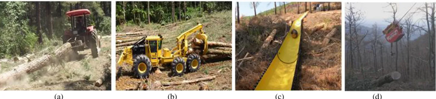
In forest transportation activities, conventional methods with little or no mechanization involvement are used in many parts of Turkey. The mechanized transportation methods are mostly implemented by using modified farm tractors during skidding
operations (Figure 1). These farm tractors are improved by 4x4 drive feature, equal loads on both axles, and protected driver cabin (Öztürk and Akay, 2007). Farm tractors are limited by the ground slope of up to 33% (Gülci, 2014). In recent years, skidders, which are specifically designed and manufactured for primer transportation of forest products, have been used by few logging companies in Turkey (Akay et al., 2016). The forest products are skidded by using chains or grapples attached to the skidders that can operate up to 40% slope (Akay and Yenilmez, 2008). On steeper grounds, forest products are transported from the woods by using a cable system that is strung in corridors through the forest. In Turkey, cable systems are used mostly in northeast part of Turkey where forests are located on steep grounds (Türk, 2011). For the forested areas where skidding operations are not preferred and cable system is not available, downhill sliding of logs within plastic chute systems by gravity is preferred at the slope of 20-60% in Turkey (Çankal, 2013; Gülci et al., 2016). Chute system potentially reduces production cost, minimizes stand damage, and prevents value loss of wood products.
(a) (b) (c) (d)
Figure 1. Primer forest transportation methods used in Turkey: a) Farm tractor, b) Skidder, c) Cable system, d) Chute system
ISPRS Annals of the Photogrammetry, Remote Sensing and Spatial Information Sciences, Volume IV-4/W4, 2017 4th International GeoAdvances Workshop, 14–15 October 2017, Safranbolu, Karabuk, Turkey
The ground slope is one of the most important limiting factors for the selection of optimum transportation methods. The stability of the forest soil is another constraint that affects the equipment selection. Soil stability reflects the mobility and potential soil impact of the mechanized equipment on forest surface (Akay et al., 2007). Therefore, alternative transportation methods should be systematically investigated by considering limiting factors such as terrain characteristics and surface soil features.
Transportation problems involving alternative solutions with various constraints can be addressed by using multi criteria decision support (MCDS) methods. In recent years, GIS tool integrated with MCDS models have been used to solve complex problems in the field of forestry (Pittman, 2003; Türk, 2011; Aydın and Eker, 2012). AHP is one of the widely used multi-criteria decision-support methods used in forestry operations (Coulter et al., 2006) to solve complex decision problems. AHP approach, first modelled by Saaty (1977), searches for the optimal solution among a set of alternative options based on set of evaluation criteria.
In this study, GIS and AHP method was used to plan primer transportation of forest products. The method was implemented in İnegöl Forest Enterprise Directorate (FED) that has very rich forest resources and intensive forestry operations involving mechanized transportation methods.
2. MATERIAL AND METHODS 2.1 Study Area
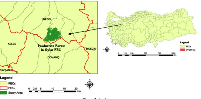
The study area was Oylat Forest Enterprise Chief (FEC) in the border of İnegöl FED in Bursa, Turkey (Figure 2). The areal distribution of forest resources with respect to FECs located in the İnegöl FED is indicated in Table 1. The dominant trees in the study area were beech, yellow pine and black pine. The average elevation and ground slope were 1005 m and 30%, respectively. The forest transportation methods available in the region included cable system, chute system, skidder, and farm tractor.
Table 1.Forest resources in İnegöl FED (ha) (URL-1) 2.2 GIS Database
Primer transportation method of forest products was planned by using GIS integrated AHP methods by considering ground slope and soil type. To generate slope and soil layers, necessary data layers including forest management map, topographic maps, and geological map were obtained from İnegöl FED. The forest management map (1:25000) was used to generate land use map of Oylat FEC. Then, forest cover was produced by delineating the forested areas that are classified as production forest. Forest cover layer was the border of the study site in the GIS applications that were implemented by using ArcGIS 10.4.1. The contour lines (with 10 m intervals) on topographical maps (1:25000) were used to generate Digital Elevation Model (DEM). Then slope map was produced based on DEM (10 x 10 m). Then, slope map was reclassified into five classes according to IUFRO slope classification suggested for transportation operations (Gülci, 2014). In this study, slope map was divided into 4 classes: 1) Steep >50, 2) High 34-50%, 3) Medium 21-33 %, and 4) Gentle/Low <21. The geological map was used to produce soil type map (10 m x 10 m) of the study area. In order to indicate stable and unstable soils, soil type map was classified into two classes.
Figure 2. Study area
FECs High Forest Degraded Forest Total Forest Boğazova 4173.50 286.00 4459.50 Hayriye 3426.50 586.00 4012.50 İclaliye 3842.00 880.00 4722.00 İnayet 3147.60 383.80 3531.40 İnegöl 8912.00 2325.00 11237.00 Mezit 2899.00 177.00 3076.00 Oylat 4386.00 566.00 4952.00 Tahtaköprü 3636.50 204.50 3841.00 Yenice 6402.00 2123.20 8525.20 Yenişehir 7053.00 12320.00 19373.00 Total 47878.10 19851.50 67729.60
ISPRS Annals of the Photogrammetry, Remote Sensing and Spatial Information Sciences, Volume IV-4/W4, 2017 4th International GeoAdvances Workshop, 14–15 October 2017, Safranbolu, Karabuk, Turkey
2.3 AHP Method
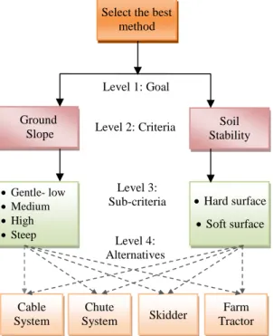
Analytic Hierarchy Process (AHP) approach was used to develop optimum primer transportation plan (Figure 3). In the solution process of AHP, four alternative transportation methods (cable system, chute system, skidder, and farm tractor) were evaluated. The main criteria included terrain conditions (slope), and soil type (stability). A weight for each criterion was generated based on decision maker’s pairwise comparisons. A numerical scale from 1 to 9 was used to measure the relative importance between two criteria (Table 2).
Figure 3. The hierarchy of AHP method
Importance
Scale Definitions 1 Equal importance
3 Weak importance of one over another
5 Essential or strong importance 7 Demonstrated importance 9 Absolute importance
2, 4, 6, 8 Intermediate values between the two adjacent judgments
Table 2. The relative importance
For each alternative method, first the relative importance values among sub-criteria were evaluated. When the criterion is the more important, the higher score was given. The normalized pairwise comparison matrix was used to compute the weighted averages of the sub-criteria. Then, “Reclassify” tool under “Spatial Analyst” extension of ArcGIS 10.2 was used to assign weighted average values to the corresponding criteria.
The importance of main criteria was compared based on the importance scale. Finally, a score was assigned to each alternative transportation method based on the decision maker’s pairwise comparisons. To control the consistency of the
evaluations, the ratio of Consistency Index (CI) and Random Index (RI) were computed. The small value of this ratio (<0.1) suggested that results drawn from the AHP method.
After consistency analysis, “extAhp 2.0” plug-in was used in ArcGIS 10.4.1 to combine the weighted averages of the criteria and determine the AHP score for each method. Finally, the optimum method with the highest score was found by a weighted sum of the scores with respect to all the criteria.
3. RESULTS AND DISCUSSION 3.1 GIS Data Layers
The areal distribution of land use types is indicated in Table 3. It was found that most of the study area was covered by forests (77.48%), and followed by agricultural areas. The land use types and production forest (study site) were shown in Figure 4.
Land Use Types Area
Production Forest/Forest 77.48
Agriculture 19.42
Open Areas (OA) 1.87
Residential Areas 0.87
OA/Stony Areas 0.20
Depots 0.17
Table 3. Areal distribution (%) of the land use types
Figure 4. Land use types
The ground slope map indicated that 37% of the study area was on medium slope class, while 29% was on high slope class (Table 4, Figure 5). About 25% of the area was classified as gentle and low slope classes, and rest of the area was on steep terrain.
The geological map was used to generate soil type map indicating stability of the surface soil (Figure 6). It was found that the soil surface was stable in 90.94% of the area, while it was unstable in the rest of the area.
Select the best method Ground Slope Soil Stability • Gentle- low • Medium • High • Steep • Hard surface • Soft surface Cable System Chute System Skidder Farm Tractor Level 1: Goal Level 2: Criteria Level 3: Sub-criteria Level 4: Alternatives
ISPRS Annals of the Photogrammetry, Remote Sensing and Spatial Information Sciences, Volume IV-4/W4, 2017 4th International GeoAdvances Workshop, 14–15 October 2017, Safranbolu, Karabuk, Turkey
Slope Classes Area
Gentle and low 25.17
Medium 36.54
High 28.82
Steep 9.47
Table 4. Areal distribution (%) of slope classes
Figure 5. Slope map
Figure 6. Soil type map 3.2 AHP Results
To compute the weighted values for the criteria and their sub-criteria a pairwise comparison matrix was generated. The weighted values of slope (sub-criteria) for alternative transportation methods were indicated in Table 5. For steep terrain, the cable system was appropriate, while chute system was suitable for high slope classes. The skidder and farm tractor were more appropriate for medium and gentle/low slope areas, respectively.
For alternative methods, the weighted values of soil type were indicated in Table 6. The cable system and chute system were suitable for unstable soil, while skidder and farm tractor were more appropriate for stable soil.
Slope Classes Cable System Chute System Skidder Farm Tractor Gentle/low 0.07 0.07 0.13 0.64 Medium 0.07 0.20 0.60 0.21 High 0.21 0.60 0.20 0.07 Steep 0.64 0.13 0.07 0.07
Table 5. The weighted values of slope class
Soil Types Cable System Chute System Skidder Farm Tractor Stable 0.42 0.30 0.90 0.80 Unstable 0.58 0.70 0.10 0.20
Table 6. The weighted values of soil type
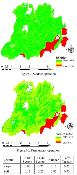
The weighted averages of the criteria were combined for the alternatives and the score for each transportation method was determined by using “extAhp 2.0” tool in ArcGIS 10.4.1. The result indicated that the most effective criterion was slope for cable system and chute system. The importance of soil was higher than slope for ground-based equipment (Figure 7-10). Table 7 indicates the weighted average values of criteria assigned to alternative transportation methods.
Figure 7. Cable system
Figure 8. Chute system
ISPRS Annals of the Photogrammetry, Remote Sensing and Spatial Information Sciences, Volume IV-4/W4, 2017 4th International GeoAdvances Workshop, 14–15 October 2017, Safranbolu, Karabuk, Turkey
Figure 9. Skidder operation
Figure 10. Farm tractor operation Criteria Cable System Chute System Skidder Farm Tractor Slope 0.83 0.75 0.17 0.25 Soil 0.17 0.25 0.83 0.75
Table 7. The weighted values of criteria
Table 8 indicates areal distribution of optimum transportation methods with the highest weighted average with respect to all the criteria. The results showed that skidder method was suggested as optimum method for 59.1% of the study area (Figure 11). The chute system was the second most favourable system (25.17%) in the study area. Cable system and chute system were the optimal methods for 9.47% and 6.26% of the study area, respectively.
Table 8. The areal distribution (%) of transportation methods
Figure 11. Optimum forest transportation map
4. CONCLUSIONS
Primer transportation of forest products is one of the most costly and time consuming forestry activities in timber extraction. Also, unplanned transportation operations may cause ecological damages, especially soil disturbance. In order to minimize these potential damages and ensure sustainability of forest ecosystem, primer transportation activities should be well planned by considering productivity and ecological effects of alternative transportation methods. The advanced features of Geographical Information System (GIS) can assist decision makers to solve such complex transportation problems. This study aimed to develop forest transportation plan by using GIS integrated Analytical Hierarchy Process (AHP) method. In the solution process, ground slope and soil type were main criteria while alternative methods were cable system, chute system, skidder, and farm tractor. The results indicated that skidder operation is the most convenient primer transportation system in the study area. The second most suitable method was other ground-based transportation method. The usage of cable system was limited by the forest areas with steep slope. Chute system was the least appropriate transportation method in the study area. It can be concluded that GIS and AHP methods can be effectively used forest transportation planning.
ACKNOWLEDGEMENTS
This study was supported by Scientific Research Project Unit of Bursa Technical University, with the project number 171L16.
REFERENCES
Akay, A.E., Erdaş, O., 2007. Estimating Rut Depth During Skidding with a Rubber-Tired Skidder. SDU Faculty of
Forestry Journal, (1), pp. 49-57.
Akay, A.E., Yuksel, A., Reis, M., Tutus, A., 2007. The Impacts of Ground-based Logging Equipment on Forest Soil. Pol. J.
Env. Stud. 16(3), pp. 371-376.
Akay, A.E., Yenilmez, N., 2008. Harvesting machines used in forest operations in North America. Chamber of Forest Engineers, Forest Engineering Journal, 45(1-3), pp. 24-28. Transportation Systems Area Cable System 9.47 Chute System 6.26 Skidder 59.10 Farm Tractor 25.17
ISPRS Annals of the Photogrammetry, Remote Sensing and Spatial Information Sciences, Volume IV-4/W4, 2017 4th International GeoAdvances Workshop, 14–15 October 2017, Safranbolu, Karabuk, Turkey
Akay, A.E., Özkan, D., Bilici, E., 2016. Assessing Productivity and Work Safety of a Mechanized Logging Operation. The
International Forestry Symposium (IFS 2016). 7-11 December,
Kastamonu, Turkey.
Aydın, A., Eker, R., 2012. Preparation of Slope Maps Using GIS Based Fuzzy Membership Model and Comparison with Classical Method: A Case Study of Avalanche Risk Assessment. KSU Eng Sci Journal, Special Issue, (1), pp.206-212.
Coulter, E.D., Coakley, J., Sessions, J., 2006. The Analytic Hierarchy Process: A tutorial for Use in Prioritizing Forest Road Investments to Minimize Environmental Effects.
International Journal of Forest Engineering. 17(2), pp. 51-69.
Çankal, H., 2013. Productivity and environmental evaluation of chute system used in log production Msc. thesis, KSU, Faculty of Forestry, Kahramanmaraş, Turkey. 39 p.
Gülci, N. 2014. Researches on precision forestry in forest planning. Ph.D. thesis, KSU, Kahramanmaraş. 264 p.
Gülci, N., Akay, A.E., Erdaş, O., Acar, H.H., Wing, M.G., 2016. Controlled sliding of logs downhill by chute system
integrated with portable winch and synthetic rope. Journal of
the Faculty of Forestry Istanbul University, 66(1), pp. 256-263.
Pittman, S.D., 2003. Elements of Hierarchical Planning in Forestry: A Focus on the Mathematical Model. Proceedings of
the Second International Precision Forestry Symposium, 15-17
June, Seattle, Washington, USA.
Saaty, T.L., 1977. A scaling method for priorities in hierarchical structures. J Math Psychol. 15, pp.234-281.
Türk, Y. 2011. The Optimization of Skid Trails Network for Extracting of Industrial Wood Based Forest Products by Farm Tractors in Forestry. Ph.D. thesis, KTU, Trabzon. 159 p. URL-1. Forest Resources, General Directorate of Forestry, Bursa Regional Directorate of Forestry, http://bursaobm.ogm.gov.tr/inegolOIM/Lists/Orman%20Varligi /AllItems.aspx (Last visited: 01/08/2017)
Yılmaz, M., Akay, A.E., 2008. Stand Damage of a Selection Cutting System in an Uneven Aged Mixed Forest of Çimendagi in Kahramanmaras-Turkey. International Journal of Natural
and Engineering Sciences, 2(1), pp. 77-82.
ISPRS Annals of the Photogrammetry, Remote Sensing and Spatial Information Sciences, Volume IV-4/W4, 2017 4th International GeoAdvances Workshop, 14–15 October 2017, Safranbolu, Karabuk, Turkey