ISSN: 1308–9196
Yıl : 6 Sayı : 14 SOSYAL BİLGİLER ÖĞRETİMİ ÖZEL SAYISI 2013
Middle School Students’ Opinions towards Geographic
Information Systems in Turkey
Nihal BALOĞLU UĞURLU
* AbstractGeographic Information Systems (GIS) have been an effective tool for the educational systems. There are many efforts for use this tool especially teaching of geography topics in the Turkish middle or secondary schools. The aim of this study is to determine Turkish middle school students’ opinions related to using of GIS in the teaching process. There were 273 middle school students (6th, 7th and 8th grade) surveyed in this research. The GIS attitudes test used in the study was prepared by the researcher. According to the research results, Turkish middle schools students’ opinions related to motivation to use GIS and the use of GIS in the teaching process were positive. They also stated that they didn’t have any significant learning difficulties with GIS. In conclusion the results were interpreted that GIS would be an appropriate tool for teaching some subject matter or curriculum content in the middle school in Turkey. Keywords: Social Studies Education, Geographic Information Systems (GIS), Educational Information Technologies, Using GIS in the Social Studies Education.
TÜRKİYE’DEKİ ORTAOKUL ÖĞRENCİLERİNİN COĞRAFİ BİLGİ
SİSTEMLERİNE İLİŞKİN GÖRÜŞLERİ
Öz
Coğrafi Bilgi Sistemleri (CBS) eğitimsel alanda kullanılan etkili bir araçtır. Türkiye’deki ortaokul ve liselerde özellikle de coğrafi konuların
*
Adıyaman Üniversitesi Sosyal Bilimler Enstitüsü Dergisi, Yıl: 6, Sayı: 14, Sosyal Bilgiler Öğretimi Özel Sayısı, 2013
öğretiminde bu aracı kullanmaya yönelik bir çok çalışma vardır. Bu çalışmanın amacı öğretim sürecinde CBS’nin kullanımına yönelik ortaokul öğrencilerinin görüşlerini tespit etmektir. Araştırmada 273 ortaokul öğrencisi (6., 7. ve 8. sınıf) yer almıştır. CBS tutum ölçeği araştırmacı tarafından geliştirilmiştir. Araştırma sonuçlarına göre, ortaokul öğrencilerinin öğretim sürecinde kullanımına yönelik görüş ve motivasyonları olumludur. Bunun yanında öğrenciler CBS’yi kullanırken hiçbir güçlükle karşılaşmadıklarını ifade etmişlerdir. Sonuçlar CBS’nin Türkiye’deki ortaokullarda bazı konuların öğretiminde etkili bir araç olarak kullanılabileceğini göstermektedir.
Anahtar kelimeler: Sosyal Bilgiler Eğitimi, Coğrafi Bilgi Sistemleri (CBS), Eğitimsel Bilgi Teknolojileri, CBS’nin Sosyal Bilgiler Eğitiminde kullanımı. 1. INTRODUCTİON
Today’s learning environment requires a variety of educational materials other than books. These materials encourage students to solve real world events encountered in daily life and develop their thinking skills and ability to acquire useful information. Students are not completely utilizing their knowledge for problem solving when they only access information found in textbooks. Nowadays, many information resources are available so that students do not limit their focus of information- gathering to textbooks only. The amount of information gathering tools is ever- increasing, enhancing student enthusiasm, which in turn promotes a richer learning environment. However, students may want to use these geographic technology devices, but they don’t know how. Channeling students toward the most efficient resources, as well as instructing them in usage of various devices is the responsibility of the teacher. This study emphasizes how Geographic Information Technology (GIS) supports the instructor in organizing lessons which guide students to understand and appreciate the world around them.
Adıyaman Üniversitesi Sosyal Bilimler Enstitüsü Dergisi, Yıl: 6, Sayı: 14, Sosyal Bilgiler Öğretimi Özel Sayısı, 2013
GIS and Its importance in education
GIS is a mapping system. This system stores, organizes, analyzes and represents geographic data. Data representations include maps, graphs or numerals. These representations are an opportunity for GIS users to see geographic events as different visualizations; users can then question and interpret geographic events in a variety of ways. Functional features of GIS can be used by different disciplines, for example, the field of education. Most importantly, the GIS can be used in the classroom to present vital information to the students via map, graphic, picture or digital information. GIS is a powerful tool that teachers can utilize in the teaching process. This tool helps students acquire knowledge in different ways and develop various cognitive skills. GIS also enables students to search for information, think about it, and feel it as well. It also contributes to critical thinking and problem solving (Simmons et al., 2008; Yap et al., 2008), carrying out spatial analysis and developing higher order cognitive skills towards research and project development. Initially, students who use GIS want to find answers to their questions with this technology. However, when they encounter a problem situation, they use their existing knowledge and experience (Drennon, 2005). Thus, it would be easy to conclude that students can access the correct information by combining existing knowledge and GIS. Also, GIS would be very effective for solving spatial problems. Students could access information from databases or map representations, using inquiry skills. They can answer their questions in more than one way, facilitating their problem solving. Furthermore, they can compare solutions which give them more options.
It is a fact that GIS increases students' self-confidence and motivation. It has also been scientifically proven that GIS increases students’ attention towards the subject (Meaney, 2006; Jenner, 2006; Baker, 2005; Kidman & Palmer, 2006, Aladag, 2010, West 2003). This is an expected result because interactive maps are more attractive than printed maps, allowing students to manipulate colors, symbols, layers and
Adıyaman Üniversitesi Sosyal Bilimler Enstitüsü Dergisi, Yıl: 6, Sayı: 14, Sosyal Bilgiler Öğretimi Özel Sayısı, 2013
features with the use of their computers. Students also enjoy comparing techniques. At the same time, they are learning from each other.
Various studies conducted on the contributions of GIS to the field of education raise the question as to how this technology can be made appropriate for the teaching process. It is acknowledged that the teachers’ negative opinions towards information and communication technologies, their lack of knowledge and practice related to GIS, the expense and hardships of forming a technical infrastructure appropriate for GIS and the extra cost of GIS software are the factors restricting the applicability of GIS in the teaching process (Lloyd, 2001; Baker 2005). However, it is true that GIS has a significant place among the modern teaching approaches. Teachers also notice that GIS is one of the most powerful tools for their classroom. Although GIS was not developed as a tool to be used in teaching with a constructivist approach, it is a useful supplement that can be applied in the computer-based constructivist teaching environment (Liu & Zhu, 2008). Students in a constructivist learning environment reach hypotheses based on their own experience and exploration of knowledge; similarly GIS may serve such a purpose in a constructivist learning environment. Students use interactive maps to find answers to the questions in their mind, and thus they explore and construct their knowledge through their own experiences. In this way, teaching integrated issues of geography, environmental science and economics with GIS-based maps which represent this information becomes an effective tool for students’ learning. However in addition to simple content knowledge, students’ manipulation of these layers of information, when guided by teachers to ask geographical questions (Alibrandi & Baker, 2008), encourage higher-order analytical skills. In that case GIS is especially a powerful tool for the learning of geographical facts and concepts. The integration of GIS with different types of data sets will facilitate learning of geographical knowledge, which is not possible through the use of database or map only (Shin, 2007).
Adıyaman Üniversitesi Sosyal Bilimler Enstitüsü Dergisi, Yıl: 6, Sayı: 14, Sosyal Bilgiler Öğretimi Özel Sayısı, 2013
There have been many studies on the effectiveness of GIS in learning environments. GIS is usually evaluated through teachers’ opinions in these studies. Studies by Audet and Paris (1997) and Barstow et al. (1994), emphasized that teachers should be trained in order for GIS to be effective in the field of education (quoted in Palmer & Kerski, 2009). As for the study by Lama et al. (2009), 75% of geography teachers in Hong Kong stated that they supported integration of GIS in the secondary school curriculum, whereas 96% stated that only 32% could actively use GIS despite receiving training on it. Baker et al. (2009) have also stated that more than 70% of the teachers state that GIS increases students’ motivation and interest towards real-world issues, leads to more geographical thinking, and serves as an exploratory tool in data analysis. In a study by Yap et al. (2008) in Singapore, it was found that more than 90% of teachers think that GIS is a suitable and useful tool for teaching and learning geography. Milson and Earle (2007) who carried out the GIS-based IGIS project with 9th graders observed that students are highly motivated in this project and experienced an increased freedom in class. In the same study it was also found that GIS is a guide in terms of the learning of key geographical terms. In the study by McClurg and Buss (2007), the teachers explained that GIS practices activate and energize students’ opinions and thus GIS could be used as an effective teaching tool in class.
What place does the GIS have in the Turkish Educational System?
National educational policies should have a positive perspective towards information technologies like GIS. Likewise, this is important for the Turkish educational system. The latest geography curriculum has suggested and supported GIS applications in secondary schools. However, this support is not clear because no information was provided about locating this program, conducting a GIS activity or developing course materials related to GIS (Incekara, 2010).
Adıyaman Üniversitesi Sosyal Bilimler Enstitüsü Dergisi, Yıl: 6, Sayı: 14, Sosyal Bilgiler Öğretimi Özel Sayısı, 2013
Some arguments seem to imply that this technology is too hard. Demirci (2009) emphasized this in his work quite clearly. Conducted with 79 geography teachers, it seems that approximately 50 percent of teachers use the computer or LCD projector in their class. In addition, only 37 percent of teachers use the internet. Only 35 percent of geography teachers were positive and declared that “GIS is understandable and can be used easily by them” and just 29 percent of them thought GIS did not need more time than other activities. However, geography teachers expressed a desire to learn and use this technology. They stated that GIS is an effective tool for their lessons (76%), and that using GIS is necessary for implementing geography lessons (51%). Additionally, they indicated that GIS is useful for student-centered instruction methods (69%), classrooms should be equipped for using GIS with the computer and LCD projector (87%), and all teachers need to learn GIS for use in the class (85%). In addition, K–12 teachers in Turkey have to complete their country-mandated curriculum. Students also take final exams at the end of 8th and 12th grade to demonstrate proficiency for admittance to a higher educational institution. These conditions are a problem for GIS applications because both teachers and students need much more time for this technology. Currently, academic curriculum encouraging GIS applications in Turkish schools are increasing daily. But, by overcoming the mentioned obstacles, GIS could integrate into the school curriculum effectively.
All these works demonstrate that if GIS can be applied in learning environment it can be an amazing tool. Although, GIS is appreciated by the researchers who want to use innovative technological tools in the educational field, education authorities and schools are generally slow in accepting and adapting to new technologies like GIS. The reason for this might be insufficient literature to demonstrate the effectiveness and benefits of using GIS for teaching and learning of academic subjects such as geography. Using GIS as a vital tool in assessing students might change teachers’ attitudes showing
Adıyaman Üniversitesi Sosyal Bilimler Enstitüsü Dergisi, Yıl: 6, Sayı: 14, Sosyal Bilgiler Öğretimi Özel Sayısı, 2013
them that GIS can be used effectively in the classroom. (Yap, et al., 2008). Until evidence convinces teachers to try GIS, they probably won’t implement it anytime soon. Increased studies in this area have been prominent but this particular research also claimed to provide contributions to existing academic works. In addition to this purpose, the author of this research aimed to expand this technology in the middle schools of Turkey. If both GIS’ importance in the educational field and the positive opinions of students toward this technology is understood by the public institutions, they would value the use of this technology in the schools. In this case, information is solicited to answer the following question:
What are the opinions of middle school students related to their desire for using GIS, using GIS in the teaching process and its difficulties in the learning process?
2. METHOD
In this study the students’ opinions were surveyed after they experienced the GIS lesson. In the GIS learning process, first the students were given lessons which were related to how they can they use GIS and they then were provided with a GIS project to apply what they learned. Through three lessons, the researcher taught them some important GIS features. These features are opening map layers, zooming in and zooming out on the map, finding the geographic coordinates, measuring distance between two points, using hyperlink features, opening graph features and accessing numeric data in the database. Next, the class lesson about Turkish natural resources was taught, which was designed to use GIS. In that step, while students learned the class materials, they were using GIS. When the researcher asked them any question related to spatial analysis she wanted them to find their answers with GIS. Sometimes, they wanted to manipulate their maps into a different shape. The researcher guided them to make desired changes. Finally, opinion scales were used to survey students’
Adıyaman Üniversitesi Sosyal Bilimler Enstitüsü Dergisi, Yıl: 6, Sayı: 14, Sosyal Bilgiler Öğretimi Özel Sayısı, 2013
beliefs and feelings about GIS and the computer.
The GIS attitudes test used in the study was prepared by the researcher to solicit students’ opinions related to using GIS as a teaching method. As a result of the factor analysis performed by means of the student responses to the 20-item scale, the six items whose factor loads fell below 0.4 were excluded from the scale. In the reliability analysis of the same scale, the Cronbach's Alpha reliability coefficient was computed 0.85, while the reliability coefficient of the 14-item scale rose to 0.87.
The 14 statements on the scale are comprised of three sub-factors, which explain the variance of 54 percent. This variance proportion is above the top of the accepted proportion, which is 41 percent (Kline, 1994 quoted in Guven & Uzman, 2006). The scale is evaluated consisting of three factors. The first sub-factor explains 19.25 percent of variance. Adding the second sub factor explains 37.53 percent of total variance, and all the factors combined explains 53.80 percent of total variance. With applied reliability analysis scale of the three sub-factors, a Cronbach’s Alpha reliability coefficient was accounted 0.77 on the first sub factor, 0.76 on the second sub factor and 0.70 on the third sub factor. When sub-factors are reviewed, six statements found in the first sub factor reflect the students’ motivation toward GIS. A total of four statements, which are found in the second sub-factor, reflect the students’ opinions regarding the use of GIS in the teaching process, and a total of four statements found in the third sub factor, reflect the students’ opinion regarding the difficulty of the GIS learning process.
Description of Sample
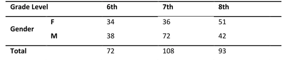
Students included in the research belonged to different public middle schools in Turkey. In this study, a survey was conducted with 273 students. Twenty-six percent (N=72) of those students were 6th graders, 40 percent(N=108) were 7th graders, and 34 percent(N=93) were 8th graders. (Table 1).
Adıyaman Üniversitesi Sosyal Bilimler Enstitüsü Dergisi, Yıl: 6, Sayı: 14, Sosyal Bilgiler Öğretimi Özel Sayısı, 2013
Table 1. Description of Sample in terms of Grade Level and Gender
Grade Level 6th 7th 8th
Gender F 34 36 51
M 38 72 42
Total 72 108 93
3.FINDINGS
Middle school students’ opinions towards GIS are as follows (Table 2):
Table 2. The Average Scores of Students’ Opinion toward GIS
N Minimum Maximum Mean S
Average score 273 2.35 5.00 4.67 .41016
The average score of students’ opinion toward GIS is 4.67. This result shows middle school students have a positive opinion toward GIS. The reason for positive student attitudes can be varied. Creating an active learning environment with GIS in the lesson would build student interest toward technology tools, encouraging students to explore new information. Seeing that GIS is a easy tool to use might have a positive impact on the attitudes of students.
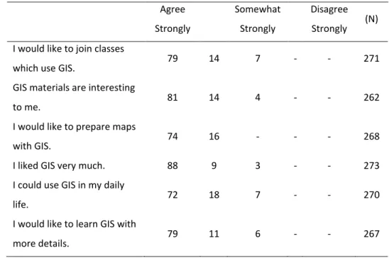
Opinions of Middle School Students about GIS Opinions Related to Students’ Motivations Toward GIS
Up to 90% of middle school students reported that GIS is also an interesting tool for students to use away from the classroom. Their responses indicate that students can use GIS in their daily life. The reason for this opinion might be related to both the features of GIS and the researcher’s methods. For example, in the teaching process, a researcher asked students “Your parent will move you to a place where you have not been before and you do not know where the place is and how long the distance is between your city and the place. Your father wants you to calculate the distance.
Adıyaman Üniversitesi Sosyal Bilimler Enstitüsü Dergisi, Yıl: 6, Sayı: 14, Sosyal Bilgiler Öğretimi Özel Sayısı, 2013
How can you get this information?” Students learned to get this information with GIS, and they realized that GIS was not only for class materials but could also apply to their daily life. In that case, they were also motivated to learn GIS and desired to further explore more details with GIS (Table 3).
Table 3. Distribution of percentage of students’ answers related to motivations toward GIS
Agree Strongly Somewhat Strongly Disagree Strongly (N)
I would like to join classes
which use GIS. 79 14 7 - - 271
GIS materials are interesting
to me. 81 14 4 - - 262
I would like to prepare maps
with GIS. 74 16 - - - 268
I liked GIS very much. 88 9 3 - - 273
I could use GIS in my daily
life. 72 18 7 - - 270
I would like to learn GIS with
more details. 79 11 6 - - 267
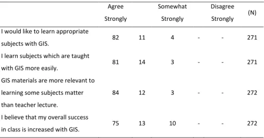
Students’ Opinions which are related to using GIS in the teaching process
Up to 90% of middle school students agree that GIS is an effective tool in their learning environment. They would like to learn appropriate subjects with GIS. Their statements indicate that they can learn some subject matter (especially geography topics) with GIS better than with the traditional learning environment and classic class materials (books, printed maps, globes etc.). Thus, their success in the class could be increased with GIS (Table 4).
Adıyaman Üniversitesi Sosyal Bilimler Enstitüsü Dergisi, Yıl: 6, Sayı: 14, Sosyal Bilgiler Öğretimi Özel Sayısı, 2013
Table 4. Distribution of percentage of students’ answers related to using GIS in the teaching process
Agree Strongly Somewhat Strongly Disagree Strongly (N) I would like to learn appropriate
subjects with GIS. 82 11 4 - - 271
I learn subjects which are taught
with GIS more easily. 81 14 3 - - 271
GIS materials are more relevant to learning some subjects matter than teacher lecture.
84 12 3 - - 272
I believe that my overall success
in class is increased with GIS. 75 13 10 - - 272
Up to 80% of middle school students do not have learning difficulties with GIS. The reason for this might be that students like to use the computer. They responded that “Because I like to use the computer I like to use GIS”. Students also said that exams taken with GIS are not difficult for them. This situation shows that students can use this technology easily (Table 5).
Table 5. Distribution of percentage of students’ answers related to learning difficulties with GIS
Agree Strongly Somewhat Strongly Disagree Strongly (N)
It is too hard learning GIS. 3 5 7 18 67 273
Because I like to use the
computer I like to use GIS. 83 10 3 2 2 269
I do not need to learn GIS. - 1 2 12 85 273
Adıyaman Üniversitesi Sosyal Bilimler Enstitüsü Dergisi, Yıl: 6, Sayı: 14, Sosyal Bilgiler Öğretimi Özel Sayısı, 2013
4. DISCUSSION AND CONCLUSIONS
This study indicates that Turkish middle school students are highly motivated to use GIS. Students want to use GIS in the learning process and display ease of learning with it. This result shows that, generally, middle school students have positive attitudes toward GIS. One reason for this result might be the positive attitudes of students toward technological materials. No one refutes this reality. Students prefer attractive and visual tools instead of printed materials, which is natural for today’s youth. Another reason why students have positive attitudes toward GIS might be that GIS is constructed using interactive maps. Interactive maps are more effective than printed maps in the learning process. Compared to printed maps for accessing information, using GIS is much easier for students. Also interactive maps support spatial analysis, problem solving and inquiry skills (Meyer, 1999; Vincent 2004; Johannson, 2003; Broda and Baxter, 2003). In addition, students improve their spatial thinking skills and use inquiry skills to access information with GIS (Lee&Bednarz, 2009; Bowman et al., 2005; Meyer, 1999). Students having geographical questions can explore different methods to access information, comparing geographic data with spatial reasoning, which allows them to explore and analyze diverse geographic features. In this way, students not only engage in research, but also begin to understand real-world application of the research. The learning environment is more spontaneous and flexible with GIS than with traditional methods and they enjoy classes much more. On the other hand, Alibrandi (2003) claimed that students enjoy many other mapping systems, for instance Google Earth. Considering this, positive student opinion is normal.
The research group in the study was willing to learn GIS. If students are willing to learn GIS it might increase their interest to pursue more advanced levels of GIS. However, the role of the teacher should not be ignored in the learning environment which is built with GIS. The use of GIS can provide meaningful information; however, providing an opportunity to manipulate the data alone is not sufficient for students' geographical learning. The teacher is the one who decides what and how to introduce
Adıyaman Üniversitesi Sosyal Bilimler Enstitüsü Dergisi, Yıl: 6, Sayı: 14, Sosyal Bilgiler Öğretimi Özel Sayısı, 2013
information to enhance students' learning, even when GIS technology is used (Shin, 2007). Thus, students can prepare different activities using this technology and they can increase their mental skills as well.
In this study applications of GIS could be reviewed in middle schools. Most middle schools in Turkey have modern computers that can be used to acquire GIS data and view thematic maps via the internet. The teachers are experienced in using the computer and internet in their lessons. However teachers don’t have sufficient knowledge about GIS. In addition, lack of GIS data sets and applications related to educational topics and difficulties about obtaining GIS software are negative conditions for usage of GIS in the schools. The first steps in using GIS in the classroom could be taken with the help of these materials. The need to obtain licenses for desktop GIS programs for the schools may be estimated later when the proficiency of teachers with GIS improves.
Finally, the use of GIS in the learning process requires multi-tasking. The viewpoint of education authorities toward GIS implies that integration of this technology with the curriculum, training teachers to use this technology, and funding schools to purchase this technology are cornerstones for implementing GIS in the field of education. REFERENCES
Aladag, E, (2010). The effects of GIS on students’ academic achievement and
motivation in seventh-grade social studies lessons in Turkey, International Research in Geographical and Environmental Education, 19(1), pp. 11–23. Alibrandi, M. (2003). GIS in the classroom: Using Geographic Information Systems in
Social Studies and Environmental Science, Heinemann Press in Porsmouth, NH.
Alibrandi, M. & Baker, T. (2008). A social history of GIS in education, 1985-2007. In Milson, A. & Alibrandi, M. (Eds.), Digital Geography: Geospatial technologies in the social studies classroom. Charlotte, NC: Information Age.
Adıyaman Üniversitesi Sosyal Bilimler Enstitüsü Dergisi, Yıl: 6, Sayı: 14, Sosyal Bilgiler Öğretimi Özel Sayısı, 2013
Baker, T. R. (2005). Internet-based GIS in support of K-12 education, The Professional Geographer, 57(1), pp. 44-50.
Broda, H. and Baxter, R. (2003). Using GIS and GPS Technology as an Instructional Tool, The Social Studies, 94(4), pp. 158-160.
Bowman, E., Kilian-Smith, R. & Brown, S. (2005). Developing Teacher Capacity to Implement GIS in the Geography Curriculum, paper presented at ESRI Education User Conference, July 23-26, San Diego, California.
Demirci, A. (2009). How do teachers approach new technologies: geography teachers’ attitudes towards Geographic Information Systems (GIS), European Journal of Educational Studies 1(1), pp. 43-53.
Drennon, C. (2005). Teaching Geographic Information Systems in a problem-based learning environment, Journal of Geography in Higher Education, 29(3), pp.385–402.
Guven, B. & Uzman, E. (2006). Ortaöğretim coğrafya dersi tutum ölceği geliştirme çalışması, Kastamonu Eğitim Dergisi, 14(2), pp. 527-536.
Incekara, S. (2010). The place of geographic information systems (GIS) in the new geography curriculum of Turkey and relevant textbooks: Is GIS contributing to the geography education in secondary schools?, Scientific Research and Essays, 5(6), pp. 551-559.
Jenner, P. (2006). Engaging students through the use of GIS at Pimlico State High School, International Research in Geographical and Environmental Education, 15(3).pp. 278-282.
Kidman, G & Palmer, G. (2006). GIS: The technology is there but the teaching is yet to catch up, International Research in Geographical and Environmental Education,15(3), pp. 289-296.
Lama, C.C., Edith, L. & Wongc, J. (2009). Implementation of geographic information system (GIS) in secondary geography curriculum in Hong Kong: current
Adıyaman Üniversitesi Sosyal Bilimler Enstitüsü Dergisi, Yıl: 6, Sayı: 14, Sosyal Bilgiler Öğretimi Özel Sayısı, 2013
situations and future directions, International Research in Geographical and Environmental Education, 18(1), pp. 57–74.
Lee, J & Bednarz R. (2009). Effect of GIS learning on spatial thinking, Journal of Geography in Higher Education, 33(2). pp. 183–198.
Liu, S. & Zhu, X., (2008). Designing a structured and interactive learning environment based on GIS for secondary geography education, Journal of Geography, 107, pp. 12–19.
Lloyd, W. J. (2001). Integrating GIS into the undergraduate learning environment, Journal of Geography, 100, pp. 158-163.
McClurg, P. A. & Buss, A. (2007). Professional development: teachers use of GIS to enhance student learning, Journal of Geography, 106, pp. 79–87.
Meaney, M. (2006). Towards Geographic Information Systems (GIS) implementation: A case study, International Research in Geographical and Environmental Education,15(3), pp. 283-288.
Meyer, J. W., Butterick, J., Olkin M. & Zack, G., (1999). GIS in the K-12 Curriculum, A Cautionary Note, Professional Geographer, 51(4), pp. 571-578.
Milson, A. J. & Earle, B. D. (2007). Internet-based GIS in an inductive learning environment: A case study of ninth-grade geography students, Journal of Geography, 106, pp. 227–237.
Simmons, M. E., Wu, X. B., Knight, S. L. & Lopez, R. R. (2008). Assessing the influence of field- and GIS-based inquiry on student opinion and conceptual knowledge in an undergraduate ecology lab, CBE—Life Sciences Education, 7, pp. 338– 345.
Shin, E. (2007). Using Geographic Information System (GIS) Technology to enhance elementary students' geographic understanding, Theory and Research in Social Education, 35(2), pp. 231-255.
Adıyaman Üniversitesi Sosyal Bilimler Enstitüsü Dergisi, Yıl: 6, Sayı: 14, Sosyal Bilgiler Öğretimi Özel Sayısı, 2013
Vincent, P.C. (2004). Using Cognitive Measures to Predict the Achievement of Students Enrolled in An Introductory Course of Geographic Information Systems, unpublished PhD dissertation, Texas A&M University, Texas.
Yap, L. Y., Tan, G. C., Zhu, X. & Wettasinghe, M. C. (2008) An assessment of the use of Geographical Information Systems (GIS), in teaching geography in Singapore schools, Journal of Geography, 107, pp.52–60.
West, B. (2003). Student opinions and the impact of GIS on thinking skills and motivation. Journal of Geography, 106(6), pp. 267-274.
Adıyaman Üniversitesi Sosyal Bilimler Enstitüsü Dergisi, Yıl: 6, Sayı: 14, Sosyal Bilgiler Öğretimi Özel Sayısı, 2013
GENİŞ ÖZET 1.Giriş
Günümüzde eğitimsel materyaller sadece basılı halde bulunan kitaplardan çıkmış, görsel anlamda zengin ve etkileşimli dijital araçlar olarak yerini almaya başlamıştır. Bu araçlar öğrencilerin günlük hayatta karşılaşabilecekleri gerçek problemlerin çözümünde onlara yardımcı olabilmektedir. Coğrafi Bilgi Sistemleri (CBS) de bu araçlardan bir tanesidir. CBS özünde bir haritalama sistemidir. Çeşitli yollardan elde mekâna ait veriler bu sistem aracılığı ile kaydedilip depolanır, düzenlemesini yapıldıktan sonra da görsel bir harita sunumu olarak karşımıza çıkar. CBS, kullanıcıları için coğrafi olayları farklı şekillerde görselleştirme ve coğrafi olayların sorgulama ve analizini yapmaya bir fırsattır. Ancak CBS’nin üst düzey kullanım alanlarının mevcudiyetinin yanı sıra eğitim alanında kullanımı ile ilgili özellikle son yıllarda yapılan birçok çalışma mevcuttur. Neden CBS’nin eğitim alanında yaygınlaştırılmasına ihtiyaç vardır? diye sorulursa CBS öğrencilerin bilgiye farklı yollarla ulaşmasını ve öğrencilerin farklı zihinsel becerilerinin gelişmesini sağlar. Eleştirel düşünme, problem çözme ya da mekânsal analiz bu becerilerden birkaçıdır.
CBS öğrencilerin sadece zihinsel becerilerini geliştirmez aynı şekilde onların kendilerine olan özgüvenlerini ve derse karşı motivasyonlarını artırır. Öğrencilerin CBS’yi kullanarak dijital haritaların içeriğindeki birçok unsuru kendi tercihleri ile manipüle etmeleri onların bu teknolojiye ilgi göstermelerinde önemli bir nedendir. Ayrıca bu teknoloji öğrencilerin birbirleri ile iletişim ve işbirliği içerisinde olmasını da sağlar.
CBS her ne kadar öğrenme sürecinde etkili ve başarılı bir araç olarak tanımlansa da bu teknolojinin ders ortamında uygulanması ile ilgili zorluklar da yok değildir. Bunlardan en önemlisi öğretmen faktörüdür. Öğretmenlerin dijital araçlara karşı olan negatif tutumları, bu teknoloji ile ilgili bilgi eksiklikleri ve bu teknolojiyi öğrenme ya da kullanma ile ilgili yaşayabilecekleri zorluklar ve onların klasik öğretim sürecini terk etmeme ile ilgili kalıp yargıları onların bu teknolojiyi derslerinde kullanmalarını sınırlamaktadır. Bunun yanında okulun teknik altyapısının yetersizliği, CBS yazılımının maliyetinin yüksek olması, haritalamada kullanılacak olan verilere ulaşmanın zorlukları da yine eğitimsel açıdan bu teknolojinin zorlukları olarak nitelendirilebilmektedir. Yine de yapılandırmacı yaklaşıma uygunluğu kanıtlanmış ve yaşanabilecek zorluklarla ilgili riskleri göze alarak bu teknolojinin uygulamalarını gerçekleştirme çabaları ileriki yıllarda bu teknolojiye daha kolay ulaşmayı ve daha aktif kullanmayı sağlayacak ortamlar oluşturacaktır.
Adıyaman Üniversitesi Sosyal Bilimler Enstitüsü Dergisi, Yıl: 6, Sayı: 14, Sosyal Bilgiler Öğretimi Özel Sayısı, 2013
2.Yöntem
Bu çalışmada, araştırmacı tarafından geliştirilmiş 14 maddeden oluşan bir anket Niğde’de öğrenim gören 273 ortaokul öğrencisi üzerinde uygulanmıştır. Anket uygulanmadan önce 10 ders saati kapsamında öğrencilerin kendilerinin CBS’yi kullanma becerilerini sağlamaya yönelik bir eğitim kursu verilmiştir. Öğrencilerin CBS’yi kullanma ile ilgili temel becerileri edinmelerinin ardından 6. sınıf Sosyal Bilgiler dersi öğretim programında yer alan Türkiye’nin Doğal Kaynakları konusu CBS kullanılarak öğrencilere öğretilmiştir. Bu aşamadan sonra da öğrencilerin görüşlerini almaya yönelik anket uygulanmıştır. Anketin güvenirlik katsayısı .85 ve geçerlik katsayısı da .87’dir. 3.Bulgular
Anket sonuçlarına göre öğrencilerin konunun öğreniminde CBS’nin motivasyonlarını artırdığına dair olumlu görüş alınmıştır. Buna göre öğrencilerin %90’dan fazlası CBS’yi çok sevdiklerini ve günlük hayatta kullanabileceklerini, CBS kullanılan derslere katılmak istediğini, CBS’nin onlara ilginç geldiğini, CBS ile bir harita hazırlamak istediklerini, ve CBS’yi daha ayrıntılı öğrenmek istediklerini ifade etmişlerdir.
CBS’nin öğretim sürecinde kullanımı ile ilgili öğrencilerin %90 ve daha fazlası CBS ile uygun konuları öğrenmek istediklerini, CBS ile konuları daha kolay öğrenebileceklerini, CBS’nin öğretmenin düz anlatımından daha fazla katkı sağlayabileceğini ve CBS’nin kendilerinin dersteki başarılarını artırabileceğini ifade etmişlerdir.
CBS’nin öğrenim zorluklarını tespit etmeye yönelik anket sorularını da cevaplarken öğrencilerin yine %90 civarında bir kesimi CBS’yi öğrenmenin zor olmadığını, bilgisayar kullanmayı sevdikleri için CBS’yi de sevdiklerini CBS’yi öğrenmelerine gerek olmadığını düşünmediklerini ve CBS ile ilgili sınav olmaktan korkmayacaklarını ifade etmişlerdir. 4.Sonuç ve Tartışma
Öğrencilerin CBS’ye ilgi gösterdikleri ve öğrenme sürecinde bu teknolojiyi kullanmak istedikleri aşikârdır. Bu durumun birçok nedeni olabilir. Bu nedenlerden bir tanesi öğrencilerin genel olarak bütün teknolojik araçlara karşı ilgi duyduklarıdır. Bu anlamda öğrencilerin CBS gibi görsel anlamda güçlü ve etkileşimli bir materyali basılı bir haritaya tercih etmeleri gayet doğaldır. Bununla birlikte CBS’nin çeşitli öğrenme becerilerini (mekansal düşünme, problem çözme, araştırma gibi) geliştirmesi öğrencilerin bu materyali kullanırken kendilerini keşfetmelerini ve kendilerine olan özgüvenlerinin artmasına neden olur. Kısacası, öğrenciler özellikle de coğrafya konularının öğreniminde klasik, tekdüze bir öğretim ortamının yerine CBS ile bütünleşmiş, aktif ve canlı bir öğrenme ortamında bulunmayı daha çok isteyeceklerdir.