THE DESIGN OF A PRODUCTIVE LANDSCAPE BARCELONA TRES TURONS
PARK, A CASE STUDY
Article CITATIONS 0 READS 175 6 authors, including:
Some of the authors of this publication are also working on these related projects:
The somatic landscape of the portuguese urban multiculturality. Identities, heritage and cultural tourism in the historical centers of Lisbon and London.View project Ana María Moya Pellitero
Universidade de Évora 20 PUBLICATIONS 11 CITATIONS
SEE PROFILE
Emrah Türkyılmaz T.C. Istanbul Kultur University 8 PUBLICATIONS 9 CITATIONS
SEE PROFILE
Çiğdem Canbay Türkyılmaz Yildiz Technical University 14 PUBLICATIONS 9 CITATIONS
The 4th International Conference of the International Forum on Urbanism (IFoU) 2009 Amsterdam/Delft The New Urban Question – Urbanism beyond Neo-Liberalism
THE DESIGN OF A PRODUCTIVE LANDSCAPE
BARCELONA TRES TURONS PARK, A CASE STUDY
Ana M. Moya Pellitero*& Emrah Türkyilmaz ** & Cigdem Canbay Türkyilmaz *** &Josué da Silva Eliziário****
*studioMEB, Mata 1, 6 2 08004, Barcelona, Spain, Email:[email protected] ** Istanbul Kültür University, 34156, Istanbul, Turkey, Email:[email protected] ***Yildiz Technical University, 34349, Istanbul, Turkey, Email:[email protected]
****studioMEB, Kempensebaan 105, 5613JC Eindhoven, The Netherlands, Email:[email protected]
ABSTRACT: Urban parks can be the future green engines of a self-sufficient urban environment. They may
become a productive landscape that merges nature, with a resource-efficient milieu, and a platform for ecological awareness and education. This agro-ecosystem sustains space and the surrounded neighborhoods, with community supported gardening and urban farming, integrating the production of renewable energies, natural water purification and waste management. Tres Turons Park is a strategic green space in the northern part of the city of Barcelona, Spain. The Modification of the Metropolitan Master Plan, approved in January 2009, consolidates the space for an urban public park. This paper evaluates how to design a community self-organized productive landscape in Tres Turons Park, presenting the design methodology and analyzing the results of the workshop taken place at the Faculty of Architecture of Barcelona (UPC), on July 2009, with an international team of students, and professional guests.
KEYWORDS: sustainability, self-organization, urban farming, renewable energies, urban park, landscape
design, education
1 URBAN PARKS: SELF-SUSTAINABLE URBAN AGRO-SYSTEMS
At the present, global urban conurbations keep growing in a continuous pace, however, within countries themselves, inequality coexists between those other cities and regions that shrink and decay. A process of economical growth, and urban development, implies the de-urbanization of other cities and regions, the degradation and erosion of weak territories, particularly rural or based in local economy. At the present, and due to the global economical crises, those cities with a high rate of unemployment and few work opportunities will start suffering this process of forced shrinkage due to migration and population loss. During the 20th century, the number of shrinking cities has increased, and in 1990 more than a quarter of all large cities in the world have already experienced population losses (T. Rieniets, 2006, p.30). It is interesting to see exponential economical and urban growth in developing countries, like China, in contrast with a long-term population decline in countries in Eastern and Southern Europe, with stagnated relevant urbanization processes. The moving of industries offshore, due to differences in wage costs, affects cities in developed countries. Only cities that are the home to the players of globalization enjoy the privilege of having stable growth and urban development (H. Müller, 2006, p.122). Cities suffer processes of development that are temporal and discontinuous based on intermittent economical global interests. The territory is a fabric of nodal centers that could be switch on and off depending on the needs of the market. When territories are switched off from the network, cities disconnect from global interests, and start decaying in slow progression. With economic decline there is a population decline. To avoid inequality, poverty and emigration, a sustainable territory is needed. Sustainability implies local interdependencies between economic, social and environmental factors. A sustainable urban environment is that one that, apart from being respectful with the environment, also offers work opportunities and a future for its inhabitants. Self-sustainability, based on local economy is necessary for the economic survival of cities, which run outside the global network. It offers stability to the urban environment in order to avoid future decay and crises.
Urban conurbations consume more than what their close physical environment can provide for their sustenance. The present economical system is reliant on high levels of consumption in order to be profitable, however the ecological footprint, which gathers the demands of human activities on the environment, duplicates, in the case of Europe, its own bio-capacity, with the danger to arrive to an ecosystem collapse for 2050 (WWF, Fund for Nature, 2006, 18-21). In the past two centuries, the increase of production has caused that agricultural and industrials emissions doubled the levels of methadone in the atmosphere, raising the CO2 concentration, despite present and future environmental damages are more critical in developing countries, where corporations have transferred industrial production centers. High levels of production (in agriculture and industry) and consume (including tourism exploitation), threatens problems of water scarcity in Southern Europe, with low precipitation and water shortages due to climate change. Societies move inevitable towards new ecological energies that will replace the energy consumption of fossil fuels. This will change transportation habits. In developed countries an important rate of energy per capita is consumed for transportation, varying country to country in relation to cultural or urban-structure habits. In less than fifty years, a change towards ecological energies (mainly solar and wind,) will influence new models of urban development.
The model of a self-sustainable urban system, inside strategic planning, will help in long term the reduction of CO2 footprint, the control of water scarcity, and the resource management of the local natural and urban environment. Already implemented examples are the eco-village BedZED (the Beddington Zero Energy Development) in Wallington, United Kingdom, designed by Bill Dunster Architects and built in 2000-2002. It is a coherent sustainable living urban development of 100 dwellings, community facilities and working space for 100 people. It encourages a green life-style that can improve the quality of life together with the environment. The houses use energy from renewable sources (solar panels and a biomass plant) for heating and electricity. The buildings are energy efficient, using renewable and recycled materials, minimizing transportation costs. The project takes in account the collection and re-use of rainwater. There is also a system of waste recycling and a communal electric transport system of car sharing. Another future self-sustainable urban development will be Montecorvo eco-city in Logroño, Spain. In 2008, the Dutch firm MVRDV and Gras, won the competition for the development of 3000 social housing. The urban development, in 56 ha, occupies 10% of the site, and the remaining space becomes an eco park, defined as a mix of park and energy production. Therefore the plan achieves a CO2 neutral footprint by producing renewable energy on site. Solar panels cover the south part of the hills, and on top of them windmills take profit of the wind energy, becoming a landmark. Water is also recycled in a purification plant. Taking this last example, it is possible to observe a danger in the invasion of technology in place of nature, in name of ecology. The natural environment and the green urban spaces become production spaces occupied by machines.
The transformation of cities into self-sustainable environments can not only depend on the introduction of eco-technologies and the creation of eco-parks. A social commitment for sustainability is needed. This commitment can be reached through collective participation, social debate, and educational diffusion. This is a challenge in the hands of a local Agenda 21 in many cities, which have accepted the responsibility to transform the actual model of urban development through mechanisms of community participation. One of them is the awareness program on environmental education in schools through projects of recycling of waste, and the work in food gardens. Only the intimate connection with the environment and a rich urban experience inside its physical materiality can make society more aware of its values and it increases environmental appreciation, respect and awareness. Urban agriculture is an ecological farming that occurs within the city. It allows growing food for local consumption, managed by the local community, renting the land to the municipality for private use or for commercial purposes inside the same local framework. The market and consumption of food (vegetables and fruit) is seasonal and organic. Increases biodiversity inside the city, reduces atmospheric pollution, saves energy consumption in transportation. However, urban agriculture will never be self-sufficient to sustain the food needs of a city, because the ecological footprint of a city is always much bigger, and there will always be the need of food imports. Despite this fact, urban agriculture allows a social interaction with the environment based in a close physical experience, helping to educate new generations, introducing inside urban society new sustainable habits, especially beneficial for elderly, facilitating social and cultural cohesion, based on the principle of ecological awareness. André Viljoen and katrin Bohn introduced in 2005, the concept of “Continuous Productive Urban Landscapes” (CPULS) as the proposition of a new urban design strategy, based on a continuous landscape inside cities.
CPULS are open spaces running the city transversally, as a continuously carpet through the built urban environment, connecting all kind of open spaces, covering the urban tissue (including roofs of buildings), without erasing its qualities. This continuous landscape, depending on the setting, can be a park, a forest, or spaces for urban agriculture, managed to be environmentally and economically productive, providing food for the close communities, establishing a healthy and sustainable balance of production and consumption. These continuous productive landscapes may change the lifestyle of people, facilitating connectivity inside cities, working and leisure habits (A. Vijoen, K.Bohn, 2005).
Urban parks, green open areas or any uncertain spaces in the city (empty vacant spaces, old buildings, brownfields, spaces left aside of urbanization) have the potential to become productive landscapes, green engines that provide resources (energy, rainwater recycling, seasonal ecological food) to the close neighborhood, self-maintained by processes of communal self-organization. Independently of their connectivity inside the city, these green engines are green islands, self-sustainable urban agro-ecosystems, spaces for recreation and rest, platform for ecological awareness and education. They encourage individuals to interact with their close environment, a physical body activity that helps the population, young and elderly, to strengthen environmental responsibility, being a platform for individual creativity, and social organisation. Food production in an urban context may seem that creates city informality, escaping formal planning. However, processes of transformation and change inside the city can also come from bottom up, from people making the city. According to the urban researcher Dr. Stephanie Geertman, self-organization is an autonomous action, based on complex and uncertain relationships happening between organizations and individuals. The individuals play a role in the creation of urban space and they have the potential to reflect and respond critically to their environment and develop themselves through learning. A landscape planning strategy establishes those designed actions that will trigger processes of change and social involvement with the environment. In this way there is an interaction between the formal and the informal, appearing a complex system that evolves over time with new stages that are not predictable by a linear causality but by a circular one that is constantly readapting.
How a self-sustainable urban agro-ecosystem can be implemented in a real urban case study? Barcelona is a city that started to shrink from 1981, with a population loss in 2000 of 14.7% (Atlas of Shrinking Cities, 2006, p.152). Its economy is not strong, due to a recession, not only caused by the global economical crises at the end of 2007, but worsen by a reduction in tourism, and an economy concentrated mainly in the sector of the brick, which has caused a national rate of unemployment of 17.36% of the active population, with the consequent reduction of consume, deflation and a debt of 115% of its GDP for 2020. In processes of urban decay, a sustainable urban model is needed. Can we apply the model of a productive landscape, self-organized in the city of Barcelona? Which urban space in the city has the potential qualities for this sustainable model? Which are the necessary planning design strategies to create a productive landscape in the selected specific location? And, which are the necessary design actions that may trigger the reaction of a community to self-sustain the space, through self-organized processes and self- maintain the landscape?
2 A CASE STUDY: TRES TURONS PARK, BARCELONA
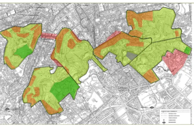
The area of “Tres Turons” (includes the hills of Creueat del Coll, Carmel, and La Rovira) is a strategic green space in the northern part of the city of Barcelona, and because of its orographic characteristics, it is a unique balcony to the city, with great environmental, historical and social values. Inside the area, there are three consolidated parks: Park Güell, part of the UNESCO world heritage, designed by Antoni Gaudí, Park La Creuta del Coll, and Guinardó Park by Jean-Claude-Nicolas Forestier, together with small gardens. The original landscape of the hills, once agro-forest, has been transformed by the human activity, containing old quarries, an anti-aircraft civil war battery, and informal urban occupation of self-constructed settlements during the post-war rural migrations, together with shanties, wastelands and sightseeing public platforms. The urban fabric surrounded this open area is dense and intensive populated without any planning, mainly by self-constructed houses, and later real estate developments, creating a mixing of different construction typologies.
Figure 1 Strategic Green in Barcelona Figure 2 The Master Plan and in its six zones
The Modification of the Metropolitan Master Plan, approved in January 2009, consolidates the space of 122 ha in Tres Turons, in its majority of public ownership, as a Park with a green area of 94 ha. The Master Plan for the new urban Park includes the demolition of illegal constructions, mainly in the top of the hills, and the resettlement of the existing inhabitants to new housing areas in the perimeter of the area. One of the main objectives of the Plan is the reinforcement of the perimeter of the park to revitalize the neighbourhoods; therefore, new facilities will be built around it. However, this Master Plan faces a big social opposition of the neighbours, because since 2004, the neighbourhood bodies propose a counterproposal, showing that the park is capable of meeting its objectives and respecting at the same time a mixed structure of housing and green spaces.
Tres Turons area is in between two poles. In one side, a governmental formal planning that prioritizes the modelling of a static and predictable formal design for Tres Turons. It uses the classical linear thinking, with a planned future where every internal property is fixed, and totally closed to contextual influences. In the other side, there is a long and historical past of social activism and self-organized processes in Tres Turons, which claim a new type of planning more concern with urban ecology that accomplishes the criteria for a local Agenda 21, for a participatory sustainable environment ( R.Balanzó, A, Borras, 2009).
2.1 Interdisciplinary approach: the practice of Landscape Urbanism
In this first decade of the twenty first century, and due to the increased awareness in ecological and environmental concerns, scholars, architects, urban planners and landscape architects became involved in the emergence of a new hybrid practice, involving urban planning and landscape. This new practice and discipline was anticipated in the Symposium “Landscape Urbanism” in 1997, organized by Charles Waldheim. Later, he, as an editor, collected essays by practitioners in all the mentioned disciplines, in the book Landscape Urbanism Reader (2006). Especially James Corner’s article, “Terra Fluxus” (2006), outlines the qualities of this new practice. First, it considers urban processes over time, second anticipates strategic
scenarios and operational logics through a wide range of scales, third reconsiders representational and operative techniques, and fourth takes in account the phenomenal richness of physical life (social imaginary, collective memory, desires, the tactile and the poetic). The new practice of Landscape Urbanism has been
experimented in postgraduate courses at the Architectural Association since 2004, centered in the representation of time-based urban processes using new representational techniques by visual modeling, and malleable graphics. It has also been discussed in roundtables and workshops, like in the Colloquium “Articulating Landscape Urbanism” organized by the Chair of Landscape Architecture in Wageningen University in 2007. Recently, the Conference at Harvard University Graduate School of Design, “Ecological Urbanism: Alternative and Sustainable Cities of the Future” in April 2009, aimed to point issues surrounding the sustainability of the city, recognizing the need for an ecological approach to the rehabilitation of the contemporary city and an organizing principle for the development of new cities.
2.2 International Workshop
The International Summer Workshop “Green Engines: Productive Landscapes for Self-Sustainable Cities” that took place in the Faculty of Architecture of Barcelona (UPC) was directed by Dr. Architect Ana Moya Pellitero from the office studioMEB and coordinated by the PhD candidate Research Assistant Emrah
Türkyilmaz from Istanbul Kültür University, with the close assistance of PhD candidate Research Assistant Cigdem Canbay Türkyilmaz from Yildiz Technical University and the Architect Josué da Silva Eliziário from the office studioMEB. It aimed to test, inside a student design studio, the implementation of a self-sustainable urban agro-ecosystem for the area of Tres Turons. The landscape design had to consider the main catalyst processes for the generation of a self-sustained green space, with a community self-organized productive landscape, where urban agriculture integrates inside a location with a heterogeneous character, embracing different historical sites. The students were introduced to the methodology of the landscape
urbanism practice.
The International Workshop, promoted by Istanbul Kültür University (Istanbul, Turkey), counted with the collaboration of Yildiz Technical University (Istanbul, Turkey), Delft Technical University (The Netherlands), University Autonomous of Barcelona (Spain), Polytechnic University of Barcelona (Spain), Elisava School of Design Barcelona (Spain), Consultancy and Engineering DHV, Department of Environment and Transportation, Eindhoven (The Netherlands), and the Department of Urban Planning from Barcelona City Council. The workshop was prepared to combine the student design studio with the presentation of lectures and the daily review of the work by professional experts in the field of Landscape Architecture, Urban Planning, Architecture, Visual arts and Geography. The workshop lasted five days, dividing the first couple of hours for lectures, and the rest of the day for the design work. Every day the students had to present publicly their work to be reviewed and commented by experts. The students were divided in three multicultural and multidisciplinary groups, mixing different levels in expertise and education. Each group was guided by assistants and invited reviewers.
2.2 Educative methodology: research-by-design
In order to introduce the methodology of work of the practice of landscape urbanism, the students had to familiarize, in a short period of time, with an interdisciplinary approach. The students had to learn to develop a design proposal that was not shaping a predictable form for the future of a space, but offering an alternative future. Their proposal had to be a planning strategy that took in account flexible dynamics, scenario thinking, and processes in time that relate with changes and re-adaptation. Because of the short period of time to develop the work, we made clear that we were not interested in the excellence of the proposal representation but in the ideas, and the learning by dialogue. The students were concentrated, not in their presentations, but in communicating everyday what they had discovered, using sketches, digital collages and renders. What is important in the practice of landscape urbanism, is to be able to move in the surface of the area of study, as a strategic platform, with an operational logic, speaking about tactics, and how those actions produce changes in the space over time. Therefore, it was necessary that the students familiarized with the exercise of moving through different scales of work simultaneously. Going from the big picture, to the intermediate scale, and the detail of a specific designed action, in order to go again back to the big picture and tell the story from the beginning again. It is then, when the students realized that the environment was not a designed object, but a complex system of elements that create a network of interactions between them. We also insisted about another important topic, basic in the understanding of how a sustainable environment works, that is, the consideration of the qualities of a phenomenal space that is lived, looking at memories, identity, and the tactile materiality of the space.
The workshop was structured in five parts. Each day the students were receiving a single task in order to help them to handle the complexity of moving through different scales. The idea was to learn by progress, testing day by day the results. With the analysis, the students were asked to evaluate the qualities and problems of the site, looking at the existing biodiversity and topography, infrastructure, existing public facilities and social use, character of the neighbourhood, boundaries, and definition of distinctive areas. Based on the analysis, the students were asked to find a planning strategy to implement a self-sustainable urban agro-ecosystem, looking at the improvement of accesses from the neighborhood to the site and the permeability of boundaries, allowing easy connections and a fluid circulation. The students had to take in account the time implementation of programmatic areas, clean energy-sources, water and waste recycling, community facilities, plot food garden division, preservation of biodiversity, new plantations, and the system of roads and paths. Different scenarios were tested to decide a clear strategy: education, tourism, recreation-health, community work (family and elderly oriented), young platforms for self-expression and commerce. Based on the strategy, the students were asked to elaborate a conceptual design that translated the planning strategy into a landscape atmosphere, which was experienced by the senses and the mind. Some
guidelines were suggested, like Conservationist conceptual design approaches (Restoration of Croscat Volcano, Girona 1993, Martirià Figueras – Joan Font); Radical (Yverdon-les-bains, Expo 02, Switzerland, West8); Ecology – machinery (Ecoboulevard in Vallecas, Madrid 2007, Ecosistema Urbano); Market-profit oriented (Explanada Forum, Barcelona 2004, J.A. martinez lapeçna- Elias Torres); or Iconographic-emblematic (La Vilette Park, Paris 1982, Bernard Tchumi). Based on the conceptual design of the landscape, different design actions were asked to be developed in detail in order to trigger change in the site, and activate the community involvement and participation. The students were asked to think those minimum necessary actions that can improve the quality of the space, guide self-organization, and activate imagination together with the ability of the user to interact with the space. The results were abstract sections and details. With the complete landscape design proposal, the evaluation helped them to compare the results of the three groups, estimating weaknesses and strengths of each proposal and elaborating a conclusion regarding the implementation of a community self-organized agro-ecosystem in Tres Turons Park.
3 THREE DESIGN PROPOSALS
3.1 Group 1: The recovery of identity: sensorial rituals, events and symbols
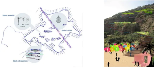
Group 1 (students: Beth Conti, Semih Cureç, Sertaç Kiliç, and Şeymanur Çelik) decided, based on the analysis, to establish a strategic planning concentrated in La Rovira hill. La Rovira gathers a layer of history (the anti-aircraft battery and the quarry), together with an important polluted space by tens of relay masts above the roof of self-built houses. They decided to preserve and accentuate the clear two different natures of the hill. One occupied by housing, the anti-aircraft battery and the quarry, and the other one, the natural forest covering the Eastern part of the hill, with its winding paths. The first strategic decision was to concentrate communal urban agriculture in the slopes of the quarry. The second one was to improve the loss of identity of the site, and the recovery of its important historical memory by the introduction of new events, happening once monthly. These events would attract the population of the city into the area in order to participate in specific memorial acts and leisure activities, and therefore to strengthen the social attachment to the site. Eco-pavilions, in the top of the hill, at the back of the anti-aircraft battery, would collect water and wind energy as a resource for the illumination of the historical site. They would also become new attractors, and night light icons for the whole city. The third strategic decision was to eliminate all the relay masts for only one antenna that would be located in a clearing in the woodland of the hill. The antenna becomes a new symbol on the site, on memorial of the war, because Tres Turons was a strategic site for the defense of the city. A fourth strategic decision was to determine two types of access to the site: one by public bus, through the winding paths of the forest, the second one, pedestrian. The pedestrian access and entrance to La Rovira is located at the base of the quarry. It becomes a ritual ascendant path experience, where the senses are activated, like the ear (the walking rhythm on different materials –wood, earth, steel- or the sound of the wind mills at the distance), smell of the flowers, the taste of the fruits in the trees, the sense of touch everywhere and the splendid 360 degrees sight of the city. Through the ascending path, different levels of vegetable gardens can be accessed. At the beginning of the ramp-promenade there is a square with a local open market, where local vegetables can be sold, reducing transportation cost energy between food production and consume.
Figure 3 Conceptual strategy Group 1 Figure 4 View of the ascendant sensorial path
3.2 Group 2: Interconnectivity and accessibility: corridors, nodes and loops
Group 2 (Inés Casanova, Kerim Ozdemir, Elisabet Badia, and Carlos Briseño) decided, based on the analysis, to set up a strategic planning concentrated in the three hills of Tres Turons. The first strategic decision was to establish a communication network of corridors, nodes and loops. This connection, through a hierarchical path system, allowed the interconnectivity among the three differentiated areas of Creueta, Carmel and Rovira. A second important strategy was to preserve the nature of the space, only upgrading specific locations, by design actions to improve the quality of the public space, and offer a platform for public activities for the city. A third strategic decision was the accessibility to the site, reinforcing three main nodes as central strategic locations for commerce, parking and pedestrian accesses. The students also studied which were the most important locations were education, tourism, recreation; young platforms for self-expression, and commerce were going mainly to be developed, despite they received the comment about the possible overlapping of these uses in the site. They developed three main design actions. One was an access node in la Rovira, at the base of the quarry. This node was a built structure of terraces, with ramps, for vehicles, in order to solve the parking congestion in the neighborhood, and to allow the pedestrian access to the upper part of the hill by elevators. This structure was covered by a technological skin of solar cells and humidity collectors. The skin covered the structure as a new topography, helping to integrate and adapt the building inside the quarry. A second action was the upgrading of the quarry of Creueta del Coll. Its natural topography allows the creation, opposite to the existing Park of La Creueta, of an amphitheater with terraces, as a platform for social gathering, concerts and festivals, and new fruit tree plantations. A third action was the development, in detail, of one of the communication network loops. A loop is a secondary path in the hierarchy of the main corridor with a circular circuit. The loop of El Carmel, crosses a self-built community, that is transformed into an urban agriculture community that takes care of the vegetable gardens. The new landscape design of the loop reinforces the existing qualities of the site, adding few improvements to fences and housing walls, path boundaries, and rain water collectors.
Figure 5 Conceptual strategy, corridors, nodes and loops Figure 6 Loop and farming community 3.3 Group 3: Sustainable tourism: leisure, employment and commerce
Group 3 (Merlin Kaşmer, Cansu Gündoğdu, and Asli Gündüz) decided, based on the analysis, to define a strategic planning for the three hills of Tres Turons. They concentrated their actions in the north and north-east side of the hills, where local self-organized gardening is possible to observe. They reinforced the processes that are already occurring in the site, creating a system of urban agriculture that is self-sustained and ecological. Small vegetable gardens, organized in a system of terraces and pedestrian paths, are rented to the citizens and to schools for educational purposes. The students create interdependency between the green as urban agriculture, connected to housing areas inside and in the perimeter of Tres Turons, to create employment and local self-sustenance. Urban agriculture could also give profit to the community by selling the goods in a food market, located in the quarry of La Rovira. This ecological food market could be an attractor for tourism and the inhabitants of the city.
Figure 7 Conceptual strategy Figure 8 Section though farming plots
The students developed two main design actions. One was the study in detail of how these terraces for vegetable gardens should be designed, taking in account storages beneath the pedestrian paths and rainwater containers. Solar panel trees along the paths would collect energy for the illumination of the site at night. A second design action was the study through sketches of the new food market in La Rovira quarry. A temporary and dismountable construction made of tensile structures could give shape to an open air market.
4 EVALUATION AND CONCLUSION
Learning to design a landscape, in the interdisciplinary practice of landscape urbanism, through a flexible and dynamic system, taking in account scenario thinking, together with complexity processes of change and re-adaptation, helped to gather a different type of design results about how the future of Tres Turons Park should be. The projection of a future productive landscape for city was not determined by a finished compositional design of the Park. Instead, all three proposals for a future productive landscape, a green engine for the area of Carmel, were respectful with what already was existing. The students understood that it was important to make visible processes that were already occurring in the site. They only needed to guide these processes by design actions, limited in specific and strategic locations that were studied carefully based on the analysis of the site. The design strategy was the core of the design, and the strategic decisions
made that, each group, could have a different result for the same park. Any of the three groups gave to their landscape design a specific landscape atmosphere, a clear design vision of a park. They simply let the site be as it is and evolve by itself, without any aesthetic make-up. All three groups realized that in order to plan a space to be sustainable, a study of the relation between different actors is needed, such as education, tourism, recreation, commerce. They also realized how important is in landscape planning to transmit and to map complex processes of interactions and relations between actors, and how difficult is to represent those mappings, which should be clear and readable. Everybody agreed that the movement through different scales in process thinking helped the students to have a clear strategy, and at the same time, to be able to understand the physical and tactile nature of the site, where people move and interact.
In the Experiential Learning Theory (ELT), there are four phases. In Concrete Experience (CE) phase, learners prefer to learn by experiencing and in Reflective Observation (RO), learners have the tendency to learn by reflecting. In Abstract Conceptualization (AC), learn by thinking, through the analysis of ideas, is the preferred learning style, and in Active Experimentation (AE), learn by doing, through active experimentation, is chosen by learners (Kolb, 1984; Aşkar, Akkoyunlu, 1993). The major phases that occur in the learning process of the students who participated in the workshop were stated as Concrete Experience (CE) and Abstract Conceptualization (AC). In Concrete Experience (CE), we have seen how students learned from feelings and life experiences with the contact with the real location. Therefore, they learned how they should use the environment and the current social and physical context, with sustainable, affordable and realistic solutions. Features such as learning by thinking, analysis, systematical approach, making new proposals were important in Abstract Conceptualization (AC) phase. As a consequence of this phase, they mostly improved their design skills as well as they learned ways of express ideas. The workshop was also a good environment for collaborative learning. It involved a coordinated design activity that was the result of continuous attempts to construct and maintain a shared understanding of the design problem.
ACKNOWLEDGEMENT
We would like to thank the support of the Faculty of Engineering and Architecture Department of Architecture at Istanbul Kültür University (Istanbul, Turkey) that encouraged us to carry out this International Summer Workshop, and the collaboration of the Faculty of Achitecture at Yildiz Technical University (Istanbul, Turkey) in the organization of the workshop. Special thanks to the critic reviewers and lecturers: Associate Prof. Dr. Vice Chair Department of Architecture Cigdem Polatoglu (Yildiz Technical University (Istanbul, Turkey); the researcher and landscape architect Fabiana Toni (Department of Urban Landscape Architecture at Delft Technical University ,The Netherlands); the Head of the Master Program in Landscape Intervention and Management Dr. Francesc Muñoz, at the University Autonomous of Barcelona (Spain); the Architect and Associate Professor Josep Ferrando, from the Department of Architectural Projects and the Architect and Town Planner Associate Professor Dr. Adolfo Sotoca, from the Department of Urbanism and Territorial Planning, faculty of Architecture, Polytechnic University of Barcelona (Spain); the Architect and Landscape Architect, Rafael Balanzó, Prof. of Elisava School of Design, UPF; and Member of Association of Sustainable Architects and Planners of Catalonia, COAC; the researcher Dr. Stephanie Geertman and the advisor Bart Muskens, both from Consultancy and Engineering DHV, Department of Environment and Transportation, Eindhoven (The Netherlands) and the visual and conceptual artist Jaime Pitarch. Special thanks to the Department of Urban Planning from Barcelona City Council for helping us providing graphic material printed and digital, and to the town planners Sara Udina and Lluïsa Morao, responsible in the elaboration of the Modification of the Metropolitan Master Plan of Tres Turons who guide us during the visit to the site. Special thanks to the Director of the Town Planning Department of the Barcelona City Council Isabel Meléndez, for her interest in the workshop and her participation as a lecturer. Special thanks to the architect, and Town Planner Assistant at the Barcelona City Council Town Planning Department Ariadna Miquel for her assistance in the preparation and during the workshop. Special thanks to the Architect Elena Albareda Fernandez, PhD candidate at the Vallés Faculty of Architecture (UPC), for her expertise and guidance in Park Güell.
REFERENCES
Rieniets, Ostfildern, Hatje Cantz, 2006.
[2] Müller, K., "Economic Transformation" in "Atlas of Shrinking Cities" edited by Philipp Oswalt and Tim Rieniets, Ostfildern, Hatje Cantz, 2006.
[3] Corner, J., "Terra Fluxus" in "The Landscape Urbanism Reader" edited by Charles Waldheim, New York, Princeton Architectural Press, 2006.
[4] WWF World Fund for Nature, "Living Planet Report 2006", Switzerland, Ropress, 2006.
[5] Viljoen, A. (Ed.), "CPULS, Continuous Productive Urban Landscapes, designing urban agriculture for
sustainable cities”, Oxford, Architectural Press, 2005.
[6] Geertman, S., "The Self-Organizing City in Vietnam, Processes of change and transformation in housing in Hanoi”, Eindhoven, Bouwstenen Publicatieburo, 2007.
[7] Balanzó R., Borras A., "Listening to the Inhabitants of our Cities for Urban Landscape in the Mediterranean Context, Case study: Tres Turons Project in Barcelona”, paper, Conference City Futures 09, 4-6 June 2009, Madrid.
[8] Kolb, D.A. , “Experential Learning: Experience as the Source of Learning and Development”, Englewood Cliffs: NJ, Prentice Hall, USA, 1984.
[9] Aşkar, P. and Akkoyunlu, B., “Kolb Öğrenme Stili Envanteri (Kolb’s Learning Style Inventory)”, Eğitim ve Bilim, No.87, pp. 37-47, 1993, (Turkish).