war-canoes of the Solomon Islands, they have their niche in the maritime history of the Pacific and are due a more systematic record before they finally disappear.
Michael Stammers Merseyside Maritime Museum, Albert Dock, Liverpool L3 4AQ, UK
References
Anon., 2001, Aak to Zumbra A Dictionary of the World’s Watercraft. Newport News. Couper, A., 2009, Sailors and Traders A Maritime History of the Pacific Peoples. Honolulu.
Finney, B., 2006, Ocean sailing canoes, in K. R. Howe (ed.), 2006, Vaka Moana Voyages of the Ancestors The Discovery and Settlement of the Pacific, 100–153. Auckland.
Folkard, H., 1853, The Sailing Boat: being a Treatise on English and Foreign Sailing Boats and Yachts. London. Haddon, A. C. and Hornell, J., 1938, Canoes of Oceania. Honolulu (repr. 1975).
Horridge, A., 1981, The Prahu: Traditional Sailing Boats of Indonesia. Kuala Lumpur.
Howe, K. R. (ed.), 2006, Vaka Moana Voyages of the Ancestors The Discovery and Settlement of the Pacific. Auckland. McKie, R. and McKie, G., 1993, Reflections of the Sepik. Bathurst NSW.
Neyret, J., 1978, Pirogues Oceaniennes. Paris.
Paris, E., 1843, Essai sur la Construction Navales des Peuples Extraeuropéens, repr. 1993 with commentary by E. Rieth, as Atlas des Voiliers et Pirogues du Monde du debut XIX siecle. Paris.
Data Collection for a Virtual Museum on the Underwater
Survey at Kas¸, Turkey
ijna_304182..231T
he Underwater Archaeological Survey Project at Kas¸, on the Lycian coast of Turkey, has emerged from a need to document, research and preserve underwater sites in the area surrounding the town of Kas¸. This region has stood out in recent decades as a centre of underwater tourism, enabling countless divers with a wide range of interests andbackgrounds to explore the coastal depths of the Mediterranean around this popular town. Rising numbers of recreational divers and increased under-water access to sites of potential historical and archaeological significance has generated an aspira-tion for their contribuaspira-tion to and participaaspira-tion in a variety of underwater survey projects. Our project has Figure 22. An older logboat used at the fish market. Note the detached float, and the banca and inshore fishing-boat in the water. (author)
emerged with the intention of bridging this gap between trained specialists and divers by identifying the underwater cultural heritage for future protection and dissemination.
Introduction
Teke peninsula is located in Lycia on the south-west corner of Asia Minor. This is a long, dangerous rocky coast, blessed by several protected ports such as Patara, Antiphellos, Aperlae, and Andriake (Hohlfelder, 2005). Lycia lay on strategic Eastern Mediterranean maritime trade-routes between the Levant, Egypt, Cyprus, the Greek islands, the Greek mainland and the Anatolian coast (Wachsmann, 1998). Among all the Lycian coasts, Kas¸ stands out as rich in historical resources, including the remains of ancient Phellos and its harbour, Antiphellos, partially integrated into modern Kas¸ (Mitchell, 1996; Zimmer-mann, 2005). Excavations on the Uluburun wreck fun-damentally influenced the development of underwater archaeology and our understanding of Late Bronze Age connections around the Mediterranean world (Pulak, 1998; Yalçın et al., 2006). Surveys of coastal Turkey have included the region of Kas¸ (Frey, 1984; Yıldız, 1984; Özdas¸, 2007; Özdas¸, 2009), but these archaeological surveys carried out in the past decades illustrate how much more information is still neither recognized nor investigated, how much more intensive survey is still needed, and how much more the under-water cultural heritage of Turkey is in need of trained divers (Parker, 1992b).
With the participation of more than 100 divers from a variety of backgrounds, and technical and logistical support from local divers and dive centres, and the Municipality and the Coastal Guard at Kas¸, and the assistance of Sualtı Aras¸tırmaları Derneg˘i (Underwater Research Society) (SAD), we have been working on developing a system for recording the underwater cultural heritage in the coastal region of Kas¸. What this pilot project intends to create is
an online inventory system to be shared by an informed community and to be continually improved by the addition of new discoveries and relevant information.
Objectives and methods
A chief aim of the project is to develop a methodol-ogy for collecting data based on trained divers who are not, by education, archaeologists. These divers can then receive a basic background that enables them to participate effectively in the Kas¸ Project. For sustainability, the Kas¸ Project intends to rely on simple, standard tools for underwater recording—buoys for marking find-spots, numbers and letters for tagging finds, plastic tapes for taking measurements, a scale and a north sign for photo-graphic recording, and plexiglass slates for underwa-ter sketching and note-taking.
The project has been developed with the objective of building and testing methods of data collection, recording, and analysis. These methods are essential for transporting the data collected in the field to an online database. A substantial portion of the infor-mation for the database derives from surveys and training conducted since 2008 from I˙nceburun, near Kalkan, on the west to Aperlae sunken harbour near Kekova on the east (Fig. 1). Initial steps were taken in 2007 to design the online database of a Virtual Museum.1 Essentially an online inventory for
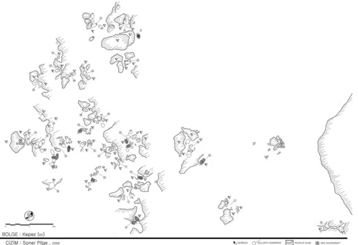
system-atic data collection, description, and analysis, the Virtual Museum currently contains information on 22 sites in the form of sketches, measurements, drawings, and photographs of finds, in addition to descriptions and observations made by divers. Combined with GPS locations of sites and find-spots, the resulting integration of the database with Google Maps illustrates the distribution of significant sites along the Kas¸ shoreline (Fig. 1).
This virtual system has particular emphasis on col-lecting the information digitally without disturbing Figure 1. Possible anchorage-sites and five potential cargo-sites in the vicinity of Kas¸. (G. Varinlioglu based on Google Maps)
the archaeological remains. Consequently, finds are recorded carefully in situ. Other projects which have developed theoretical and methodological approaches to in situ analysis of underwater sites and finds include the Ancient Port of Caesarea (Alves, 2008: 83) and Florida’s Underwater Archaeological Preserves (Scott-Ireton, 2006: 5). Such an approach also ensures the protection of sites in line with the UNESCO 2001 Convention, one of whose basic principles encourages in situ preservation of underwater cultural heritage (UNESCO, 2001).
Particular care to avoid physical intervention in the archaeological record has resulted in recording only what is above the sea-bed. This is a limiting factor in attempts to gather the maximum amount of informa-tion at any given site without excavainforma-tion. At the same time, the information which can be gathered without de-contextualizing the artefacts helps to gain general insight into the nature and the extent of sites and pro-vides a foundation for further and more detailed research. The range of material visible consists mainly of amphoras and other sizeable artefacts such as large ceramic vessels or even pithoi, stone and metal anchors, and ballast-stones, millstones and architec-tural cargoes. Whether or not a site might produce preserved remains of ship-parts is difficult to deter-mine without excavating. Subsequently, sites are cat-egorized as anchorage-sites if there is a wide range finds from different periods, and as cargo-sites if they have groups of finds of similar types and date. ‘Cargo-site’ is preferred to ‘wreck-‘Cargo-site’, which is only used when hull remains survive. In areas which contain large numbers of sites, the best-preserved examples and unique finds are selected for photography, drawing, and recording of detailed measurements
(Fig. 2). Additional measurements are collected to contribute to determining the wider extent of the site using offset and trilateration measurements (Bowens, 2009: 120–22).
Recorded sites
The database for the Kas¸ Project currently includes records of c.600 finds at various locations. Out of 22 archaeological sites, six possible anchorage-sites and five potential cargo-sites have significant characteris-tics as explained below (Fig. 1).
Anchorage-sites
The anchorage sites at Kovanlı, Körmen-Çılpacık, Kalkan-Heybeli, Gürmenli Islands and I˙nceburun, Çapabanko Inlets, are described as probable mooring-sites along ancient maritime routes. These mooring-sites have produced remains of a variety of anchors and a wide range of amphoras and other types of pottery scattered on the surface of the sea-bed. Furthermore, these sites are often located on the east of the adjacent landmass, so protected from the harsh westerly winds prominent in this region. Such observations bring to mind discus-sions on the suggestion that ancient mariners often tried to hug the shoreline for safety and attempted to take shelter behind protective landmasses at night, at rising conditions of danger or in harsh weather (Parker, 1992a: 4–7; Wachsmann, 1998: 297). In addi-tion, the diversity of amphora and anchor types recog-nized at these six sites potentially indicates different chronological periods and illustrates the long-lasting use of these sheltered areas by seafarers during their voyages across the Lycian coast of Turkey (Foss, 1994).
Cargo-sites
Scattered ceramic and anchor remains clustered at five areas in the vicinity of Kas¸, at Bucak, Üçkaya, Kepez Inlets, Kas¸-Heybeli and Besmi Islands, have been interpreted as possible cargo sites. Situated not far away from notorious reefs and rocks above water, these cargo-sites are often open to harsh weather. Of the five, three seem to have been considerably damaged, most probably through deliberate looting. These sites at Bucak Bay, Cape Üçkaya, and Kas¸-Heybeli Islands are all located in relatively shallow waters. The remains at Bucak Bay are near notorious rocks above water named as Köfte Island, exposed to westerly winds at Cape Çukurbag˘, on the west of the sheltered inlet of Port Vathi. The completely disturbed site covers an area of over 50 m at a depth ranging from 6 to 10 m. Also very damaged, the second cargo-site is recognized at depths ranging from 10 to 24 m and near a hidden reef exposed to westerly winds at Cape Üçkaya on the south of Kas¸. Presumably includ-ing more than one wreck, this partially disturbed site covers an area over 100 m. The third of these disturbed sites is located further south, at a depth of between c.12 and 24 m, on the west of a group of five small rocky outcrops, commonly called the Kas¸-Heybeli
Islands. Remains at this site include various amphoras of similar types, ballast-stones and a T-shaped anchor.
Two apparently undisturbed cargo-sites were discov-ered in deeper waters, with maximum depths of c.30 and 45 m. The first is located to the north of the rocky island of Besmi, located 1.2 nautical miles west of Kastellori-zon and 3.1 nautical miles south of Kas¸. Although the area of Besmi is regularly visited by recreational divers, the fact that the remains cover a wide area 34–46 m deep might explain the lack of disturbance; most of this site appears to be relatively well preserved. Remains at Kepez, the second undisturbed cargo-site, are found on the west coast of the mainland c.2.5 nautical miles east of the Greek island, Kastellorizon, and c.2.4 nautical miles south east of the modern town of Kas¸. Finds are scattered in an area of 50 m, between 16 and 43 m deep. Observations include one T-shaped anchor and 115 undisturbed and 146 broken amphoras of 11 different types. Although survey done by Cemal Pulak in 1983 mentions relatively fewer amphora types, Kepez cargo-site might possibly be the Roman Wreck (Wreck #7) dated to the 4th century AD, discovered by a team from INA and Bodrum Underwater Archaeology Museum in 1983 (Yıldız, 1984: 23).
Recording methodology
During the survey, the divers tested various recording techniques throughout different stages of the Kas¸ Project. Work carried out at Cape Kepez best illus-trates the current stage in the development of the project’s survey and recording methods. The site was investigated during a total of 221 dives covering an area of c.50 x 75 m (Fig. 3). Divers marked each pile of finds with a number and each individual find with a letter marked on a small plexiglass slate. These numbers enabled find-spots to be investigated during multiple dives and by different groups of divers. These tags also provide a link between types of recorded data within the structural design of the database when the finds are entered into the system, enabling connections to be made between multiple sketch drawings, mea-surements made by different teams and multiple photographic and video recordings, each of which could be made on different dives (Fig. 4).
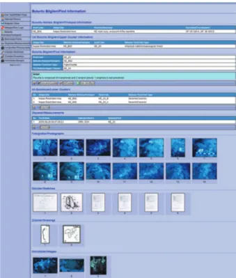
At Kepez, divers counted 115 undisturbed ampho-ras and a T-shaped anchor in small sandy niches on the rocky sea-bed. All the measurements, sketches of finds, observations, and photographic records were entered into the database after the completion of each dive in the following manner: in the case of ceramics, descriptions of rim, neck, handle, shoulder, base, and body types were separately documented in addition to height, width, rim, neck, base diameters, Figure 4. Online database entry for the find KE_23.
and shoulder and handle heights. In certain cases, details such as handle sections or observations made on body decoration such as rips, were also included in the database (Fig. 5). Similarly, anchor descriptions and measurements of various details were collected and noted. These will eventually provide suggestions for the origins and dating of distinct types of discoveries.
Conclusion
After the process of updating the data collected during the last season of work at Kas¸, the project will be resumed with studies of amphora and anchor-types in order to investigate implications of interconnections and chronological frameworks of the finds. As the project was started because of an evident need to inform interested parties on the underwater cultural heritage of Kas¸, particular care is placed on the devel-opment of survey and training methods. A series of
training programmes was created for the participants (Varinliog˘lu, et al., 2007). Within the framework of this programme, survey techniques were developed, tested and practised at a modern ‘wreck’-site, Archaeopark, created in 2006 at Hidayet Bay, c.1.5 nautical miles west of the modern town of Kas¸. This project had come to life under the guidance of a col-laboration between SAD and 360 TAD (360 Degree Research Group), which have both supported the Kas¸ Project since its preliminary stages. In addition to archaeological prospecting, the project intends to advance much-needed training and educational public programmes on the underwater cultural heritage of Kas¸ and its surrounding area.
Güzden Varinliog˘lu Faculty of Art, Design and Architecture, Department of Interior Architecture and Environmental Design, Bilkent University, Turkey, and Underwater Research Society (SAD), Turkey
Note
1. Data collection for an online database forms the author’s dissertation project in the Faculty of Art, Design and Architecture at Bilkent University, one of the goals of which is to contribute to the management of underwater cultural heritage in Turkey. The database in the dissertation builds on what was designed during The Virtual Museum of Turkish Underwater Cultural Heritage: Kas¸ Archaeopark Pilot Project during summer 2007 under the sponsorship of TÜBI˙TAK, through collaboration between the Culture and Art Research Center of Bas¸kent University and SAD. Serkan Girgin of the Middle East Technical University designed the database, while Altay Özaygen, of the same university, worked on its internet application.
Acknowledgements
My thanks to TÜBI˙TAK, ARIT, AKMED for financial support; all the staff of SAD and ODTÜ-SAT for their contribution and Kas¸ Local Government for logistical support for Kas¸ Underwater Survey Project 2009–10; also countless divers and dive centres at Kas¸ for generous assistance on all levels of the project; and the Turkish Ministry of Culture and Tourism, Antalya Museum, for providing the permit for this dissertation project. Lastly I am indebted to Elif Denel for critiques on the archaeological aspects of the project, to Bülent Özgüç for support on my dissertation, and to Haluk Camus¸cuog˘lu, Murat Draman and Burak Özkırlı for assistance all along the project.
References
Alves, F. J. S., 2008, Underwater Archaeological Trails, Museum International 60.4, 81–90. Bowens, A., 2009, Underwater Archaeology: The NAS Guide to Principles and Practice. Oxford. Frey, D. A., 1984, Turkish Coastal Survey, INA Newsletter 10.4, 4.
Foss, C., 1994. The Lycian Coast in the Byzantine Age, Dumbarton Oaks Papers 48, 1–52.
Hohlfelder, R. L., 2005, Aperlae in Lycia: Ancient Maritime Life beyond the Great Harbors. Classics Ireland 12, 13–30.
Mitchell, S., 1996, Review: Lycia, Classical Review, 46.1, 103–05.
Özdas¸, H., 2007, Ege ve Akdeniz Bölgeleri sualtı aras¸tırması 2005 yılı çalıs¸maları, 24 Aras¸tırma Sonuçları Toplantısı, 2006, 433–50. Ankara.
Özdas¸, H., 2009, Akdeniz Bölgesi sualtı aras¸tırması 2007 yılı çalıs¸maları, 26 Aras¸tırma Sonuçları Toplantısı, 2008, 259–72. Ankara.
Parker, A. J., 1992a, Ancient shipwrecks of the Mediterranean and the Roman provinces. BAR S580, Oxford. Parker, A. J., 1992b, Cargoes, containers and stowage: the ancient Mediterranean, IJNA 21.2, 89–100. Pulak, C., 1998, The Uluburun shipwreck: an overview, IJNA 27.3, 188–224.
Scott-Ireton, D., 2006, Florida’s Underwater Archaeological Preserves: Preservation through Education, Underwater Cultural Heritage at Risk (Special Issue of Heritage at Risk), 5–7. ICOMOS.
UNESCO, 2001, Convention on the Protection of the Underwater Cultural Heritage, http://unesdoc.unesco.org/images/0012/ 001260/126065e.pdf, accessed 28/06/10.
Varinliog˘lu, G., Ülkenli, H., Denel, E., Türkmenog˘lu, E.. and Pilge, S., 2007, Kas¸ Arkeopark Alanında Sualtı Aras¸tırma Metodları Çalıs¸tayı, 11 Sualtı Bilim ve Teknoloji Toplantısı, 37–43. I˙stanbul.
Wachsmann, S., 1998, Seagoing Ships and Seamanship in the Bronze Age Levant. College Station TX.
Yalçın, Ü., Pulak, C. and Siotta, R. (eds), 2006, Uluburun Gemisi. 3000 Yıl Önce Dünya Ticareti. 15 Ekim 2005–16 Temmuz 2006 tarihleri arasında Bochum Alman Madencilik Müzesi’nde (Deutsches Bergbau-Museum Bochum) düzenlenen serginin katalog˘u. Bochum.
Yıldız, Y., 1984, 1983 Sualtı batık gemi aras¸tırmaları, 2 Aras¸tırma Sonuçları Toplantısı, 21–9. Ankara.
Zimmermann, M., 2005, Feldforschungen in Phellos (Lykien) 2003, 22 Aras¸tırma Sonuçları Toplantısı 2003, 45–52. Ankara.
Comments Concerning Recent Fieldwork on Roman
Maritime Concrete
ijna_305188..237I
n recent years the most important advance in underwater archaeology vis-à-vis hydraulic con-crete structures for Roman maritime installations has been made by the Roman Maritime Concrete Study (ROMACONS) project, directed by Brandon, Hohlfelder, and Oleson, dedicated to analysing the composition and manner of use of the elements making up the concrete mixtures (Oleson et al., 2004a; Oleson et al., 2004b; Brandon et al., 2005; Hohlfelder et al., 2007; Gotti et al., 2008). In many cases pulvis puteolanus was present as an essential element. This, the construction material recom-mended by Vitruvius and found on the Phlegrean and Neapolitan coastline of Campania, was transported as far as Caesarea Maritima (Branton and Oleson, 1992).With a view to verifying how widely pozzolana was used (for example, we would expect it to have been used in Mauretania in the port of Jol-Chercell under Juba II), or to analyse and evaluate structures created with other combinations of materials, samples of con-glomerate for analysis have been taken by means of drilling. The sites studied so far are: Cosa, Santa Lib-erata, Portus, Antium, Baiae, and Gnathia. Similar research has also been carried out at Chersonesos in Crete (Oleson et al., 2004b: 206; Brandon et al., 2005). The results, which have mostly already been published, provide useful information. Among the most obvious, the presence of pozzolana has been confirmed on many sites, and one of the structures of the port of Cosa has been dated by C14 to the mid-1st century (57–33) BC, which is almost a century later than had been previously supposed (McCann, 1987; McCann, 1998: 43; see also Oleson et al., 2004b: 217ff.).
The general purpose of this paper, stimulated by the results produced by the ROMACONS project, is to review the chronology for the early use of opus caementicium for building structures in the sea. In addition, a review of supposed structures at Carthago Nova indicates that they do not relate to the harbour, but very probably to a temple, while the pilae at Tarraco and Ampurias are also not definitely mari-time structures.
Identifying the earliest example
The structure at Cosa had been thought to be the oldest identified example of maritime construction using hydraulic concrete. Another potentially early site, roughly contemporary with the Porticus Aemilia, which is thought to be the first large-scale use of con-crete at Rome (Liv. XL, 51, 4), is the mole built by M. Aemilius Lepidus on his properties at Terracina in 179 BC (D’Arms, 1981: 36). Now, however, the revised date for Cosa perhaps makes such an early instance of the use of pozzolana much less likely.
The application of this technique in the sea, due primarily to the use of pulvis puteolanus in the mixture making up the caementicium, is indirectly attested only at a later date. The first instance of the creation of piscinae for fish-farming, built in the sea by Sergius Orata in the first years of the 1st century BC, occurred in precisely the area which Vitruvius (II, 6, 1 and V, 12, 2–3) notes as having pozzolana of the best quality; all the more effective if, Pliny adds, ‘Cumano misceatur caemento’ (NH XXXV, 166, see also Strabo V.4.6; Sen., Nat. Quaest. 3.20.3). There is, therefore, no reason for doubting that the technique was invented and applied extensively along the whole littoral of the Phlegrean Fields during the construction boom of the late Repub-lic and early Principate. This was a time when other daring experiments were also conducted on land, as can be seen, for example, in the vaults of the Baths of Baiae. The previous chronology for the mole at Cosa slightly anticipated this scheme, but nevertheless constituted a useful reference-point for the study of other ports. Now, however, some of them must be reconsidered in the light of the new dating. This is the case with Carthago Nova, to which an inscription (CIL I, 2:2271 (= I,1477) and 3:1104; CIL II, 3434 (suppl. 5927) and p.952; ILLRP 778) mentioning the construc-tion of concrete piles refers. Since this inscripconstruc-tion is dated to the late-2nd or first half of the 1st century BC (Abascal Palazón and Ramallo Asensio, 1997: 71–7, n.1, pl.1; Gianfrotta, 2008a: 73f.), the associated port would replace Cosa as the oldest known example of construction with hydraulic concrete in the sea. After listing at length the magistri who dedicated it, the