Virtual Archaeology Review, 8(17): 20-30, 2017 http://dx.doi.org/10.4995/var.2017.5963
© UPV, SEAV, 2015 Received: June 16, 2016 Accepted: April 20, 2017
*Corresponding author: Ahmet Denker, [email protected] 20
REBUILDING PALMYRA VIRTUALLY: RECREATION OF ITS FORMER
GLORY IN DIGITAL SPACE
RECONSTRUCCIÓN VIRTUAL DE PALMIRA: RECREACION DE SU ANTIGUA GLORIA EN UN ESPACIO DIGITAL
Ahmet Denker
Faculty of Engineering and Natural Sciences, Istanbul Bilgi University, Eyup 34060, Istanbul, Turkey. [email protected]
Abstract:
This paper addresses the role of the digital tools and methods in the preservation of cultural heritage. As the destruction of Palmyra made international headlines, digital tools emerged as a key tool to fight back against the total deletion of the heritage site from memories. Palmyra in Syria had been, with its Corinthian colonnades, theatre and splendidly built temples to ancient gods, source of inspiration and imagination for Western architecture. In this paper, the aim is reviving the lost reality of Palmyra by digitally reconstructing its “ghost images” from rubbles. The paper offers a glimpse of the grandeur and beauty of the ruins of Palmyra, none of which any longer remains in its entirety. 3D models of the most significant structures of Palmyra, including Temple of Bel and Temple of Baalshamin which have been levelled as a result of conflict based vandalism, as well as the Grand Colonnaded Street and the theatre are presented as “ghost images” through reconstructed 3D models. The focus has been in maintaining the accuracy and validity of the visualised data of the relics and environment of Palmyra, as they were once extant. Following the trauma caused by the destruction of Palmyra, these reconstructions revive in our memory the splendour of the city in the Greco-Roman Period.
Key words: virtual archaeology, UNESCO world heritage site (WHS), 3D reconstruction, digital cultural heritage Resumen:
Este artículo trata el papel de las herramientas digitales y los métodos en la preservación del patrimonio cultural. Si bien la destrucción de Palmira propició titulares internacionales, las herramientas digitales han emergido como una herramienta clave para defenderse contra la supresión total de las memorias del sitio patrimonial. Palmira en Siria, ha sido con sus columnatas corintias, teatro y los templos de los antiguos dioses construidos espléndidamente, una fuente de inspiración e imaginación en la arquitectura occidental. Este artículo ofrece una vista rápida de la grandeza y la belleza de las ruinas de Palmira, ninguna de las cuales permanece hoy en día. Los modelos 3D de las estructuras más significativas de Palmira, como son el Templo de Bel y el Templo de Baalshamin, así como la gran columnata monumental y el teatro, que han sido severamente destruidos a causa de los conflictos vandálicos, se presentan como “imágenes fantasma” a través de los modelos reconstruidos en 3D. El enfoque ha sido mantener la precisión y la validez de la información visualizada de las reliquias y del ambiente de Palmira, tal y como eran antiguamente. Siguiendo el trauma causado por la destrucción de Palmira, estas reconstrucciones reaniman en nuestras memorias el esplendor de la ciudad en la periodo Grecorromano.
Palabras clave:arqueología virtual, patrimonio mundial de la UNESCO, reconstrucción 3D, patrimonio cultural digital
1. Introduction
The cultural heritage which holds a significant part of the intellectual wealth of our information society has constantly been under threat of demolition. The threats of destruction have originated primarily, from local and international dissents and conflicts. Throughout history war has always taken a toll on heritage as well as human lives. Damage by Talibans of the 1700 years old Buddhas of Bamiyan at a World Heritage Site (WHS) in Afghanistan in 2001 was followed by the demolition of the antique city of Palmyra in Syria by ISIS (Islamic State of Iraq and Syria) in 2005.
Pliny the Elder said: "Situated in a vast expanse of sand and renowned for its fertile soil and pleasant streams, the ancient city of Palmyra was a stopping point for caravans traversing the Syrian Desert" (Pliny the Elder, Natural History 5.88.1). An oasis in the Syrian Desert,
Palmyra was known as “the Venice of the sands” and “the bride of the desert”.
Palmyra used to contain well preserved temples which were consecrated to ancient Mesopotamian gods, a colonnaded street with Corinthian columns, a theater, and the valley of tombs. It had long been counted among the most eloquent and stupendous ruined cities from the ancient world. As one of the outstanding cultural centers of the world, it was also listed as a UNESCO’s WHS (Campbell, 2007).
The city rose to prominence 2000 years ago during the reign of "the warrior queen", Zenobia, who resembled Cleopatra of Egypt in many ways. She had reigned like Cleopatra and was defeated by Romans like her. Her regina concurred with an epoch when Romans began to take interest in Palmyra, firstly for economical and lately for political reasons. An abrupt rise of Roman interest for
oriental goods led to sudden growth in Palmyra to the size of one of the largest cities in the East. It linked Roman world to Mesopotamia; caravans were transiting Palmyra while crossing the Syrian Desert, and their transit brought wealth to the city. Its sudden and huge prosperity was also put to an abrupt end in Roman hands. From the day when Aurelian terminated Zenobia’s rule of desert, the roads of commerce diverted, and the fortune of Palmyra dwindled (Seyrig, 1950).
As the latest act in the dark history of vandalism, ISIS destroyed Temple of Baalshamin (24 August 2015). It was followed by Temple of Bel (31 August 2015), the Grand Colonnaded Street and the Arch of Triumph (4 October 2015). They were unique monuments of a hybrid architectural style which blended Greco-Roman canons with ancient Middle-Eastern architecture. Most of the landmarks of Palmyra are now gone. With their destruction and disappearance, irreplaceable treasures of the UNESCO WHS are lost to posterity.
3D computer graphics and virtual reality are the only known means of remedy for our collective and irreversible loss. Since 2015 there have been several undertakings in order to revitalize the memory of the lost splendor of Palmyra, by reconstructing the city in 3D. “Revive Palmyra“, “The New Palmyra“, “Ghost of Palmyra“, and “The Virtual Palmyra“ are some of titles given to the projects which seek to resurrect Palmyra. “The Virtual Palmyra” was launched by the author and its results were presented in a relatively confined way in the 8th ARCHEOLÓGICA 2.0 Conference (Denker 2016). This paper forwards a more extended treatment on the subject and offers a glimpse of the grandeur and beauty of the treasures of Palmyra, none of which any longer remains in its entirety. 3D models of the most significant structures of Palmyra are put forward, including Temple of Bel, Temple of Baalshamin which have been levelled as a result of conflict based vandalism, as well as the Grand Colonnaded Street plus Great Tetrakionion and the Triumphal Arch. The 3D reconstruction of the theatre which had been the scene of numerous executions is also included.
2. Digital construction of virtual
representations
The project aims at reaching the following goals: 1. The 3D reconstruction of each of the lost edifices of
Palmyra in as close form to their original as possible.
2. The placement of the individual models within the recontextualized 3D environment.
3. Piecing together the individual 3D models and the 3D environment to establish a comprehensive virtual representation of the whole of Palmyra.
Reaching these goals requires the availability and accessibility of the following data:
Graphical and photographic data. Archaeological survey data. Topographical data.
When the data is missing and architectural elements are destroyed due to ravages of time and humankind, other
sources are sought for filling the missing information. In the case of Palmyra, it is possible to reach a large volume of information. Textual and graphic descriptions governing the ancient architecture of Palmyra exist in literature (Wiegand, 1932). Each demolished temple and the other landmarks of the city, colonnaded road, theatre, etc. were to a great extend recorded.
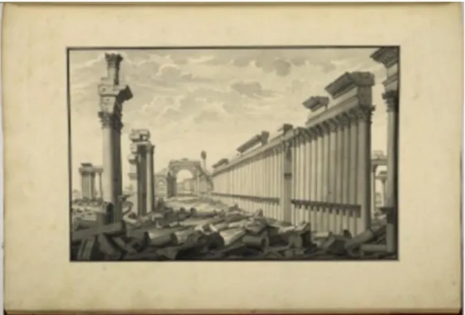
Recognition of the splendour of the ruins of Palmyra by travellers in the 17th and 18th centuries contributed greatly to the subsequent revival of classical architectural styles and urban design in the West. The work of British explorer Robert Wood may be used as an instance (Wood, 1753).This work appeared subsequent to Wood’s visit to Palmyra in the course of a voyage he undertook with "two gentlemen whose curiosity had carried them more than once to the continent, particularly to Italy."
They thought that “a voyage, properly conducted, to the most remarkable places of antiquity, on the coast of the Mediterranean, might produce amusement and improvement to themselves, as well as some advantage to the public”, as he stated in the preface to his book. The success of the book is primarily due to the drawings carried out by Giovanni Battista Borra. These were the first accurate records of the monumental ruins of Palmyra.
Wood tells how he joined them in the book as follows: "a fourth person in Italy, whose abilities as an architect and draftsman we were acquainted with, would be absolutely necessary. We accordingly wrote to him (Giovanni Battista Borra), and fixed him for the voyage. The drawings he made, have convinced all those who have seen them that we could not have employed anybody more fit for our purpose."
With Giovanni Battista Borra’s drawings (Fig. 1) which were engraved in 1753, Wood’s book has been the main repository of information as regards to graphical data.
Figure 1: Drawing of the colonnaded street by Giovanni Battista Borra.
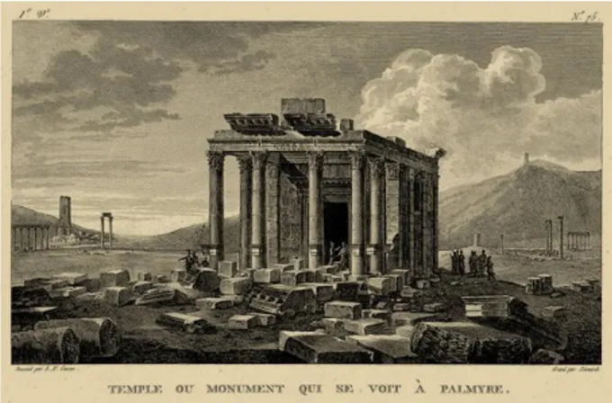
Another important source of graphical data has been the drawings of Louis François Cassas (Cassas, 1900). Cassas had travelled to Palmyra in 1785. He made several drawings of the ruins of Palmyra. His drawings are of indispensable value in providing the much needed graphical data about these ruins (Fig. 2).
Transporting this information into digital models may be compared with Evans’ procedure of "translation from drawings to buildings" (Evans, 1995). His proposition,
Figure 2: Drawing of Temple of Baalshamin by Louis François Cassas.
"there is only one communicant, and that is the drawing", inspires a digital process which ends up with the casting of the digital construction through a series of geometric projections of drawings.
However, drawings of Giovanni Battista Borra and Louis François Cassas have some intrinsic limitations. Not everything can be arrived through them, e.g. texture, colour and light. Hence, efforts for digital construction of virtual representations which start from the drawings of Giovanni Battista Borra and Louis François Cassas, require absorption of supplementary data.
Photos taken between 1867 and 1876 by Felix Bonfils, which provide the most complete visual record of Palmyra from the 19th century, have been another indispensable information source which enabled the realisation of this project.
What engaged the greatest attention in this project has been what the monumental relics of Palmyra looked like in ancient times. We have tried to reconstruct their ancient state rather than their pre-demolition state.
3. Temples of Palmyra
Unlike the other major cities of the eastern provinces of Rome where a single monumental temple to the patron god dominated the landscape (e.g. Temple of Artemis at Ephesus, Temple of Apollo at Didyma), there were numerous temples in Palmyra. The reason for this lies behind the sophisticated religious structure of the city. Although from their outward appearance they looked Greco-Roman the deities they housed were not.
Due to its semi-nomadic social structure which is composed of individual branches rooting from the same stem there was no real Pantheon in Palmyra, that is to say no generally accepted gods hierarchy. According to the ancient written sources, there were four commonwealth constituent tribes, each settled in a different part of the city. Each tribe worshiped, besides its own local deities, gods of various origins. In addition to indigenous Arab deities, they worshiped gods whose origins can be traced back to north or southern Syria, Arabia or Mesopotamia (Schmidt-Colinet, 1995).
Palmyra had four main temples which corresponded to these four commonwealth constituent tribes: the Temple of Baalshamin, for the "Lord of Heaven", the Temple of Nabu, for the Mesopotamian god of wisdom and oracles like Apollo, the Temple of Allat for the goddess who can be equated to Athena. Above all, was the big Bel Temple
which was the common sanctuary for all of the four tribes. It was almost a national cult centre and represented all of Palmyra (Schlumberger, 1971). Bel originated from the great god of Babylonia which shows before the Greco-Roman influence, inhabitants of Palmyra were culturally dependent on Babylon (Seyrig, 1950). Bel was identified as "Father God" of the universe like Zeus of the Greeks and Jupiter of the Romans. The cosmic nature of Palmyrean Gods is expressed in that it occurs in a deity trio in cult community with Yarhibol, an old God associated with the sun, and Aglibol, a lunar deity. Also Baalshamin, which as God of heaven, fertility, lightning and rain was equated with the Greco-Roman Dionysus/Bacchus. Bel was often portrayed together with Yarhibol and Aglibol representing the Sun and the Moon; the three gods formed a triad. A 1st century AD relief in Louvre Museum shows Bel between Aglibol and Yarhibol. Unlike the Greco-Roman deities who were constantly in quarrel, cooperation resided among the gods of Palmyra (Gawlikowski, 1995).
The cult of the individual gods practiced organised priest processions. These cult processions were led by the necessary liturgical actions as sacrifice and prayer and organised regular worship processions. The most important sacrificial rites were the burning of incense in small fire altars or the offering of fruits (Schmidt-Colinet, 1995).
Palmyra’s temples were the remarkable examples of monumental architecture which blended the Greco-Roman architecture with Oriental architecture. The hybrid elements of these temples demonstrated the numerous cultures that frequently overlapped and inter-mixed in Palmyra. Temples of Palmyra were among the greatest architectural achievements of humankind until they fell victim to vandalism. They drew on wealthy, canonical forms stemming from both Greco-Roman and Ancient Near Eastern roots (Veyne, 2015).
In an exhibition put up by the Smithsonian's Freer and Sackler galleries in 2015, the main theme was that the temples of Palmyra were a prime inspiration for the Neo-classical architectural style in Britain and North America. They have had a direct influence on US architecture, including buildings such as the Capitol, the White House and Monticello, the Virginia’s home of President Thomas Jefferson (O’ Brien, 2015).
4. Digital reconstruction
There are several stages of digital reconstruction of an ancient site. These include 2D drawing of antique monuments in comparative dimensions; placing them in relative positions and orientations on the site plan; creating 3D graphical elements with surfaces composed of a number of polygons. These surfaces are given photorealistic appearance through the use of appropriate texture maps and lighting. The placement of the light sources which generate the solar illumination and shadow effects in Syrian Desert were imperative for creating the right atmosphere. When rendered the reconstructed 3D virtual objects exhibit the characteristics of the real objects.
A variety of software tools have been implemented for the realisation of these phases in the Palmyra restitution project. Autodesk AutoCAD® was employed for 2D drawings of plans and elevations. The software used for
the 3D reconstruction of Palmyra was Autodesk 3ds Max®. In this project, when the virtually created 3D objects were integrated according to the city plan, the file was comprised of more than 1 million polygons and its size exceeded 2.5 GB.
The environment surrounding the integrated 3D objects is important for creating the "realistic looking" scenes. It includes topography, vegetation, background images and sky.
5. Digital reconstructions of temples
Out of the four major temples of Palmyra, Temple of Nabu and Temple of Allat were left alone by ISIS probably due to their low state of preservation compared to Temple of Bel and Temple of Baalshamin. The heart was ripped out of everyone with the news of destruction of the other two. The scale of devastation was immense and the losses were irretrievable.
Virtual reconstruction/recreation is the only available means for soothing the pain of the loss of these temples. We have aimed at the production of photo-realistic reconstructions and visualisations of Temple of Bel and Temple of Baalshamin and present the results below.
Figure 3: 3D reconstruction phases and final "realistic looking” view of Temple of Bel.
Lumion® was implemented for construction of the environment. As an example, the 3D reconstruction phases of Temple of Bel and its final view are shown in Figure 3.
5.1. Great Temple of Bel
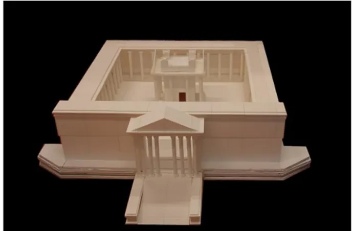
In the south-eastern part of the old city which was enclosed by the ancient wall, used to arise the main temple of Palmyra, Temple of Bel. It was one of the four main temples of Roman Syria, together with Temple of Jupiter in Damascus, Baalbek Temple, and the Jerusalem Temple built by Herod the Great. What made Bel unique was that it was the only one of those four which was preserved in shape and form.
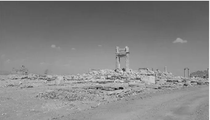
Satellite pictures taken after Syrian government forces retook the city, showed the entire structure collapsed in
a heap of rubble (Reuters, 2016). The only part which remained from the temple was the western doorway into the sanctuary building (Fig. 4).
Figure 4: The only part which remained from the Temple of Bel is the western doorway into the sanctuary building (Photo by
Maher Al-Mounes/AFP/DGAM) (Al-Mounes, 2016). Before blown up by ISIS in 2015, on the last day of August, Temple of Bel was the most impressive and renowned building in Syria. It was the vestige with which Palmyra was associated. It was consecrated to Bel, the chief of the Palmyrene Gods, the equivalent of Greek Zeus and Roman Jupiter. Its relic was preserved remarkably well and constituted the most outstanding part of the ruins. It used to exhibit the splendid synthesis of Greco-Roman and Ancient Near Eastern Architectures.
The temple building was on a podium in the middle of an almost square open court (175 x 180 m). It was well framed by a portico of 30 m depth which meant that the outer dimensions of the temenos were extended to 205 x 210 m.
There were Corinthian columns on the outside wall, and porticos had double rows of Corinthian columns. One exception to this was the west side where there was only one row.
The temple stood in the court asymmetrically, facing the north. Its main axis tilted only by 5º from the North-South axis.
The main axis of the temple divided the open court in two portions with a ratio of 3:2. Western and eastern portions were approximately 105 m and 70 m deep, respectively (Figs. 5 and 6).
Figure 5: Shaded bird’s eye drawing of the Temple of Bel and its temenos [in m].
Figure 6: Shadowed flank elevation drawing of the Temple of Bel [in m].
At the level of stylobate the main temple building stands over a rectangular area of 29.52 x 54.6 m.
The cella was a rectangular building which was of 15.8 x 39 m. It was surrounded by one row of columns (Fig. 7).
Figure 7: Plan of the main temple building [in m] (After Seyrig et al., 1975).
The order was Corinthian. The columnar arrangement was pseudo-dipteral. There were 8 columns at façades, 12 at the west flank and 14 at the east flank. Column height was 15.81 m, and base diameter was 1.33 m, the height of the building was 33.14 m (Fig. 8).
Figure 8: Flank Elevation of the main temple building [in m] (After Seyrig et al., 1975).
The asymmetry of columns at the flanks is a noteworthy aspect of Bel’s architecture. It was due to
that access to the cella was not through a frontal door. The door was placed asymmetrically on the side wall which required the visitor to turn 90º in order to view the cult area (Fig. 9).
Figure 9: Reconstructed flank-elevation of Temple of Bel (west-side).
From the ancient inscriptions as well as the different architectural style of the colonnades surrounding the peribolos, it was understood that the temple building was older than its surrounding (Wiegand, 1932).
In its outward appearance, the temple looked to derive from the canon of Hellenistic architecture (Fig. 10).
The entrance to the inner court was from west side through a monumental propylaeum of 35 m width (Fig. 11).
It occupied almost one-sixth of the front wall. Visitors were led to the gate through a majestic staircase. A protruding portico with 8 columns was decorating the front elevation.
The isomorphic reconstruction of this temple was presented in (Seyrig et al., 1975).
Figure 10: Reconstructed façade of Temple of Bel.
The drawings of Propylaeum were given in Wood’s book. After Palmyra was recaptured, it was obvious that the damage to Bel -the most important monument of Palmyra- was extensive.
5.2. Temple of Baalshamin
Temple of Baalshamin was situated 200 m north of the Grand Colonnaded Street. It was facing east. The main temple building was situated in a semi-rectangular shaped temenos with a maximum length of 163 m and a maximum width of 58 m (Fig. 12).
Figure 12: Shaded bird’s eye drawing of Temple of Baalshamin and its temenos [in m].
As with Temple of Bel, Temple of Baalshamin also exhibited hybridity in design. The Greco-Roman traits were demonstrated by its colonnaded precinct, prostyle, façade and tetrastyle structure (Collard, 1970).
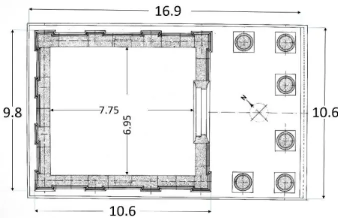
The main temple building was standing on a 10.6 m x 16.9 m stylobate (Fig. 13). The four free standing columns in the portico were finished in Corinthian order. They were 7.8 m high and standing on attic bases; the total height of the building was 12.9 m (Fig. 14). Cella walls were decorated by Corinthian style flat plasters.
Figure 13: Plan of the main temple building [in m] (After
Wiegand, 1932).
Alongside overall classical Greco-Roman appearance, it also embodied prominent Near Eastern motives. The most visible of them were the windows of cella (Figs. 14 and 15).
Windows were also used in the Temple of Bell. These windows which did not exist in the Greco-Roman cannon signified that the Deity was inside. They also let more light inside the cella than usual. The Association for the Protection of Syrian Archaeology reported that the
temple was destroyed by ISIS in August 2015. The 3D reconstructions of Temple of Baalshamin and its surroundings are shown in Figs. 16 and 17.
Figure 14: Drawing of the flank elevation of Baalshamin [in m] (After Wiegand, 1932).
Figure 15: Shaded drawing of the portico of Baalshamin [in m].
Figure 16: Reconstructed outer-view of Temple of Balshamin and its environment.
Figure 17: Reconstructed view of the temenos of Temple of Baalshamin.
6. Digital reconstructions of other
landmarks
6.1. Grand Colonnaded Street
Grand Colonnaded Street, or decumanus, used to strike the travellers by the distinctly Roman imperial aspect it had bestowed upon city. It was another of Palmyra's great archaeological site with an architecture that fused Greco-Roman techniques with local traditions and Persian influences. The street stretches about 1200 m. It was built in three stretches over the course of a century starting from the 2nd century, but never finished.
The western portion was the first part to be built, it was also the longest, stretching over 500 m (Butcher, 2003). The middle portion connected the western and eastern stretches. A Tetrakionion (Sec. 5.2) marked where the Central section met the Eastern section. Eastern section ended with the Triumphal Arch. The width of the street extends to 22.7 m at the widest places and diminishes to 11.7 m at the narrowest parts (Barański, 1995).
The columns were topped with Corinthian capitals and mounted on Attic bases. Despite the character of the columns, pertaining to the characteristics of ancient Greek and Roman architectures, they also carry some indigenous features. A noteworthy example of these is the presence of brackets half-way up each column. They were located to hold the statues of dignitaries.
The colonnaded street itself was the most significant of the traits of Eastern tradition in Palmyra. This is because, in contrast to the ubiquitousness of the colonnaded streets in the Eastern provinces of the Roman Empire, they were almost completely absent in the Western provinces (Ball, 2014). What lied behind the colonnades were rows of shops. Dedicatory inscriptions were found on the columns. One of them was dedicated to Zenobia.
Grand Colonnaded Street of Palmyra (Fig. 18) was arguably the most famous of the surviving colonnaded streets until it was destroyed in October 2015. It had given to Palmyra an architectural unity, a common thread that brought Eastern, Western and Central sections of the city together (Watkin, 2011).
Figure 18: Reconstructed view of Grand Colonnaded Street. 6.2. Triumphal Arch and Great Tetrakionion Grand Colonnaded Street changes direction at two locations in order to reach the Temple of Bel. One of these is punctuated by the Tetrakionion where Central section meets the Eastern section. The other is marked by the Arch of Triumph.
The beauty of the Arch of Triumph was so imposing that it became the symbol of Palmyra soon after the first illustrations of its ruins were published in the 18th century
in Wood’s book (Wood, 1753).
Tetrakionion of Palmyra which is believed to be constructed at the end of the 3rd century is one of the most striking constructions of the city. It is a prominent echo of the columnar architecture of the Roman world. It is composed of four tetrapylons which appear overall as four separate structures. Each tetrapylon consists of four columns which are topped by a solid cornice (Fig. 19). Columns are supported by plints at the corners of a square. It stood in a circular piazza marking the junction of Central and Eastern sections of the colonnaded street (Fig. 20).
If one progresses south-eastward through the Eastern section of the Grand Colonnade he comes to the Arch of Triumph. The Arch of Triumph was built in the 3rd century, after the propylaeum of the Temple of Bel was finished. It gave an uninterrupted line of sight towards the great temple (Fig. 21).
When the traveller reaches from Tetrakionion to the Arch of Triumph his gaze is directed inevitably towards the gate of the temple which was probably the cause why the Arch of Triumph had been placed at this point. A possible explanation of their origin might be the sacred processions.
It is tempting to conjure the Eastern section as a processional road which started at Tetrakionion, continued through the Arch of Triumph, and ended at the Temple of Bel. How the Arch of Triumph was connected to the temple is not known. This part of the Grand Colonnade was never finished.
Figure 19: Drawing of the Great Tetrakionion [in m] (After Wiegand, 1932)
Figure 21: Triumphal Arch and the eastern end of the Grand Colonnaded Street.
It is tempting to conjure the Eastern section as a processional road which started at Tetrakionion, continued through the Arch of Triumph, and ended at the Temple of Bel. How the Arch of Triumph was connected to the temple is not known. This part of the Grand Colonnade was never finished.
6.3. The Theatre
The Theatre of Palmyra is another building which has a totally western form. The theatre is a horseshoe-shaped (Fig. 22) building with a cavea of 92 m in diameter and an adjoining portico. It was surrounded by a ring-shaped area of 104 x 82 m (Figs. 23 and 24).
Figure 22: Scaled bird’s eye drawing of the Theatre of Palmyra [in m].
This expansive area had been very likely to be used both by the visitors of the theatre and by the caravan dealers who were coming to market their merchandise at the Agora. This area was excavated in (1959-1962). It was buried by then under 5 m high sand. It was brought to daylight only after several thousand tons of rubble and sand were removed especially in the western and north-western areas.
7. Holistic virtual representation of
Palmyra
The reconstructed individual models of the temples and other landmarks of Palmyra have been pieced together with the 3D environment to form the virtual model of Palmyra as a whole.
This stage of visualisation was imperative for the reconstructed city to accurately represent its now demolished counterpart in reality. It is at this stage that
not only the monuments but the entire city of Palmyra has been brought back from rubble, by using the techniques of virtual reality.
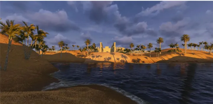
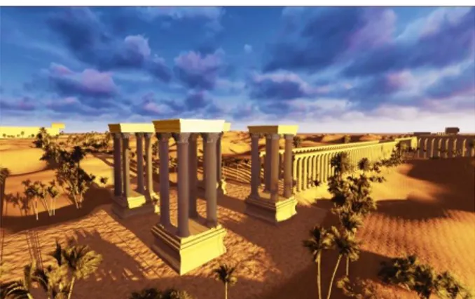
The topographical model of the landscape was covered with the natural fauna and vegetation. Its “pleasant streams“ as described by Pliny were also added (Fig. 25).
With the illumination effects of sun setting and the walls of the temples turning gold and pink in the desert light, Virtual Palmyra makes one feel a deep connection across the centuries to the city’s heyday when Queen Zenobia was walking through the Grand Colonnade to the Temple of Bel (Fig. 26).
8. Conclusions
Palmyra was not only historically significant, but it was also beautiful. The 150000 tourists who were visiting it every year used to be entranced by what they saw: The ruins of an ancient city rose in splendour as an oasis in the surrounding Syrian Desert. Regrettably, since the end of 2015 summer, the view that tourists used to savour no longer exists. Ancient Palmyra had crumbled into obscurity in the surrounding desert.
The defining feature of the devastation in Palmyra was the intentional targeting of the cultural and religious heritage. The assaults were directed at monumental structures which symbolised and contained material evidence of Palmyra's multi-cultural identity. Traditional methods of cultural heritage conservation are of little use when one is faced with such a deliberate targeting. After the city was recaptured, the scale of devastation was seen: The UNESCO WHS was reduced to rubble and almost integrated with the enclosing desert. With looting and destruction of the relics of the historical city, irreplaceable evidences of ancient life and societies were lost forever.
3D computer graphics, through technological innovations, offers an ability in ‘reconstructing the past’ beyond those originally imagined. Considering that the disappearance of heritage is an impoverishment of the intellectual wealth of all nations, the use of this capacity of 3D computer graphics in archaeology and cultural heritage entices careful consideration. Starting from the 90s (Forte and Siliotti, 1997) the use of 3D computer graphics in relation with archaeology and cultural heritage has been a focus of attention for scholars in multi-disciplinary fields. An abundance of publications have emerged in the last two decades which have presented photo-realistic reconstructions of the past (Logothetis et al., 2016) and (Manferdini et al., 2016). This stream continues to make contributions to the creation of a new legacy in cultural heritage.
With the advent of affordable 3D printers, a new window has been opened to a new horizon. This development enables tangible reconstruction of lost edifices of cultural heritage in full 3D. The application of the state-of-the-art 3D printing technologies to Virtual Palmyra project has already provided successful results (Fig. 27).
Visualisation opportunities that are increasing being developed by technological progress have been opening new horizons for reminding the past existence of the lost treasures of our cultural heritage. As new technological creations stream on, we become more and more able to virtually recreate the ruined cities and flattened
Figure 23: Reconstructed view of the theatre. Figure 24: Reconstructed close-up view of the stage.
Figure 25: “Pleasant streams“of Palmyra as described by Pliny.
Figure 27: Temple of Bel after 3D printing.
monuments and their past. Reconstructions of the past with the advent of 3D computer graphics, high resolution rendering and 3D printing are increasingly produced and maintained in digital form, thus creating a new type of legacy: Digital cultural heritage. With this work Virtual Palmyra has been created as a new edition to our digital cultural heritage. Virtual Palmyra is one of the means for depriving the terrorists of the opportunity of deleting Palmyra from our collective memory.
Acknowledgements
The author acknowledges with pride the contributions of his students Berk Gencan, Eren Can Yildirir, Mehmet Cicekler and Meltem Sezer in the creation of the 3D reconstructions of this project.
References
Al-Mounes, M. (2016). Assessing the damage at Palmyra. Retrieved from https://gatesofnineveh.wordpress.com/ 2016/03/31/assessing-the-damage-at-palmyra/
Ball, W. (2016). Rome in the East: the transformation of an empire, 2nd Ed. London & New York: Routledge.
Barański, M. (1995). The Great Colonnade of Palmyra reconsidered. ARAM Periodical, 7(1), 37–46. http://doi.org/10.2143/ARAM.7.1.2002216
Butcher, K. (2003). Roman Syria: And the Near East, Paul Getty Trust Publications.
Campbell, G. (2007). "Palmyra", The grove encyclopedia of classical art and architecture. Oxford University Press. http://doi.org/10.1093/acref/9780195300826.001.0001
Cassas, L. F. (1900). Voyage pittoresque de la Syrie, de la Phoenicie, de la Palaestine et de la Basse Aegypte. Paris: Impr. de la République. Available at http://digi.ub.uni-heidelberg.de/diglit/cassas1800bd3/0001
Collart, P. (1970). Reconstruction du Thalamos du Temple de Baalshamîn a Palmyre. Revue Archéologique, Nouvelle Série, 2, 323–327
Denker, A. (2016). Virtual Palmyra: 3D reconstruction of lost reality of “the bride of the desert”. In J. L. Lerma & M. Cabrelles (Eds.), Proceedings of Arqueológica 2.0, 8th International Congress: Advanced 3D Documentation, modelling and reconstruction of cultural heritage objects, monuments and sites (pp. 318–320). Valencia: Editorial Politècnica de València.
Evans, R. (1995). The projective cast: architecture and its three geometries. MIT Press.
Forte, M., & Siliotti, A. (1997). Virtual archaeology: re-creating ancient worlds. London: Harry N Abrams B.V.
O’Brien, J. (2015). Palmyra: ruins that inspired the architecture of power. In BBC News, Washington, 27 July 2015. Available at http://www.bbc.com/news/magazine-33659376
Gawlikowski, M. (1995). Bel of Palmyra. In M. Bomer-A. Lichtenberger-R. Raja (Eds.), Religious identities in the Levant from Alexander to Muhammed (pp. 247–255). Brepols Publishers.
Logothetis, S., & Stylianidis, E. (2016). BIM open source software (OSS) for the documentation of cultural heritage. Virtual Archaeology Review, 7(15), 28–35. http://dx.doi.org/10.4995/var.2016.5864
Manferdini, A. M., Gasperoni, S., Guidi, F., & Marchesi, M. (2016). Unveiling Damnatio Memoriae. The use of 3D digital technologies for the virtual reconstruction of archaeological finds and artefacts. Virtual Archaeology Review, 7(15), 9– 17. http://dx.doi.org/10.4995/var.2016.5871
Pliny the Elder, Natural History 5.88.1.
Reuters (2016). Palmyra's dynamited Temple of Bel can be restored, de-miners use robots. Available at http://blogs.reuters.com/faithworld/2016/03/31/palmyras-dynamited-temple-of-bel-can-be-restored-de-miners-use-robots/
Schlumberger, D. (1971). Les quatre tribus de Palmyre. Syria, 48: 121–133.
Seyrig, H. (1950). Palmyra and the East. The Journal of Roman Studies, 40(1&2), 1–7. http://doi.org/10.2307/298497
Seyrig, H., Amy, R., & Will, E. (1975). Le Temple de Bel à Palmyre, Vol. I, II. Album, Texte et Planches, Institut Français d'Archéologie de Beyrouth, Bibliothèque Archéologique et Historique. T. 83. Paris: Librairie orientaliste Paul.
Veyne, P., (2015). Palmyra Requiem für Eine Stadt, Verlag C.H. Beck oHG, München. Watkin, D. (2011). A History of Western Architecture. Laurence King Publishing 5th edition.
Wiegand, T. (1932). Palmyra Ergebnisse der Expeditionen von 1902 und 1917. Text-und Tafelbd. Available at http://digi.ub.uni-heidelberg.de/diglit/wiegand1932ga
Wood, R., (1753). The ruins of Palmyra, otherwise Tedmor, in the desert. Available at http://digi.ub.uni-heidelberg.de/diglit/wood1753
![Figure 8: Flank Elevation of the main temple building [in m] (After Seyrig et al., 1975 )](https://thumb-eu.123doks.com/thumbv2/9libnet/4278844.68851/5.892.87.422.458.702/figure-flank-elevation-main-temple-building-seyrig-et.webp)
![Figure 22: Scaled bird’s eye drawing of the Theatre of Palmyra [in m].](https://thumb-eu.123doks.com/thumbv2/9libnet/4278844.68851/8.892.82.427.595.803/figure-scaled-bird-s-eye-drawing-theatre-palmyra.webp)