DANUBIAN BORDER IN THE SECOND HALF OF THE 16th CENTURY: REVOLUTION AND TRANSFORMATION, TRADITION AND
CONTINUATION ON THE EVE OF A NEW ERA
A Ph.D. Dissertation
By
NURAY OCAKLI
Department of History
İhsan Doğramacı Bilkent University
Ankara
DANUBIAN BORDER IN THE SECOND HALF OF THE 16
thCENTURY: REVOLUTION ANF TRANSFORMATION, TRADITION
AND CONTINUATION ON THE EVE OF A NEW ERA
Graduate School of Economics and Social Sciences
of
Ġhsan Doğramacı Bilkent University
By
NURAY OCAKLI
In Partial Fulfillment of the Requirements for the Degree of
DOCTOR OF PHILOSOPHY IN HISTORY
in
DEPARTMENT OF HISTORY
ĠHSAN DOĞRAMACI BILKENT UNIVERSITY
ANKARA
I certify that I have read this thesis and have found that it is fully adequate, in scope and in quality, as a thesis for the degree of Doctor of Philosophy in History.
--- Prof. Dr. Halil Ġnalcık Supervisor
I certify that I have read this thesis and have found that it is fully adequate, in scope and in quality, as a thesis for the degree of Doctor of Philosophy in History.
--- Asst. Prof. Dr. Evgeny Radushev Examining Committee Member
I certify that I have read this thesis and have found that it is fully adequate, in scope and in quality, as a thesis for the degree of Doctor of Philosophy in History.
--- Prof. Dr. Mehmet Seyitdanlı Examining Committee Member
I certify that I have read this thesis and have found that it is fully adequate, in scope and in quality, as a thesis for the degree of Doctor of Philosophy in History.
--- Prof. Dr. Özer Ergenç
Examining Committee Member
I certify that I have read this thesis and have found that it is fully adequate, in scope and in quality, as a thesis for the degree of Doctor of Philosophy in History.
--- Asst. Prof. Dr. Nur Bilge Criss Examining Committee Member
Approval of the Graduate School of Economic and Social Sciences
Prof. Dr. Erdal Erel Director
iii ABSTRACT
DANUBIAN BORDER IN THE SECOND HALF OF THE 16th CENTURY: REVOLUTION AND TRANSFORMATION, TRADITION AND CONTINUATION
ON THE EVE OF A NEW ERA Ocaklı, Nuray
Ph.D., Department of History Supervisor: Prof.Dr. Halil Ġnalcık
July 2013
This study focuses on pre-Ottoman Turkic presence and their remainings as the first phase of the Turkic presence and examines how the Ottomans adapted, re-organized and re-structured the existing military organizations, distribution of population and settlement system against the changing priorities and military concerns of the central authority during the 15th and 16th century as the second phase of the Turkish presence in the Danubian frontier. As the turning point on the eve of a new era, this study examines reactions of pre-Ottoman military aristocracy most of whom were Christian former nobles excluded from the timar system. Their rebellious attapt broken out at the end of the 16th century was supported by the anti-Ottoman alliences formed on the north of Danube as a continuation of the rebellious tradition of the region. The resulting picture of the Danubian frontier in the 15th and 16th century reveals the tradition and continuation, revolution and transformation in the Nigbolu Sandjak during the period from the post conquest era to the end of the 16th century, on the eve of a new era.
Key words: Nigbolu, Rumelia, Danube, Frontier, Cuman, Nomads, Voynuks, Tirnova.
iv ÖZET
16.YY’IN ĠKĠNCĠ YARISINDA TUNA SINIRI: YENĠ BĠR DÖNEMĠN ARĠFESĠNDE DEĞĠġĠM VE DÖNÜġÜM, GELENEKSELLĠK VE DEVAMLILIK
Ocaklı, Nuray Doktora, Tarih Bölümü Tez Yöneticisi: Prof.Dr. Halil Ġnalcık
Temmuz 2013
Bu çalıĢma öncelikle bölgedeki Türk varlığının ilk safhası olarak Osmanlı öncesi Türk yerleĢimcilerine ve bunun Osmanlı dönemindeki izlerine odaklanmakta ve Tuna sınırındaki Türk varlığının ikinci safhası olarak Osmanlılar’ın 15.yy ve 16.yy boyunca bölgedeki askeri düzeni, nüfus yapısını ve yerleĢim sistemini nasıl yeniden yapılandırdığını ve kendi sistemine uyarladığını incelemektedir. Bu çalıĢma 16.yy’ın sonunda, Bulgar Devleti’nin ve feodal aristokrasinin merkezi olan Tırnova bölgesinde, isyancı geleneğin bir devamı olarak, askeri sınıfın dıĢında bırakılmıĢ Hıristiyan boyar ailelerinin ve ruhban sınıfının ileri gelenlerinin merkezi otorite karĢısında gösterdikleri tepkileri değerlendirmektedir. Tuna serhaddinin bu analizler sonunda çizilen resmi yeni bir dönemin arifesinde Niğbolu Sancağı’nda gelenek ve devamlılığın, köklü değiĢimlerin ve dönüĢümlerin nasıl yan yana var olduğunu göstermektedir.
Anahtar Kelimeler: Nigbolu, Rumeli, Tuna, Sınır, Kuman, Yörük, Voynuklar, Tırnova.
vi
TABLE OF CONTENTS
ABSTRACT……… iii
ÖZET... iv
TABLE OF CONTENTS... vi
LIST OF TABLES AND GRAPHS... ix
CHAPTER 1: INTRODUCTION...……….………..………….. 1
1.1 Measurement of Demographic Data ……….…………... 7
1.2 Niğbolu as the Gate of Danubian Frontier Region………. 10
1.3 Geography, Climate and Nomadis...………... 11
1.4 Conquest of Nigbolu ……….. 13
1.5 Ottoman Rule in the Nigbolu Sandjak……… 15
1.5.1 Timars and Timariots……….. 15
1.5.2 Native Christians: Migrations, Deportations, Population…... 17
1.5.3 Bogomils in Ottoman………...………... 20
1.6 Town and Village System in the Ottoman Nigbolu…...…………. 22
1.7 Ottoman Social, Economic and Military System in the Sandjak..…. 24
1.8 Scope and Focuses of the Study………..………... 27
CHAPTER 2: ANATOLIAN IMMIGRANT PROFILE AND CHANGING SETTLEMENT PATTERNS OF 15TH CENTURY OTTOMAN NIGBOLU………... 31
2.1. Population Pressure in Anatolia and Depopulation of the Old Settlements in The Danubian Region……….... 31
2.2. Motives of the Central authority to Transplant Population from Anatolia: Revival of Old Villages and Re-populating the Empty Lands………..… 34
2.3. Deportation and Volunteer Immigration from Anatolia……..…….. 37
2.4. Motivations of Sufi Orders………..………... 40
2.5. Cities and Big Towns: Demography and Settlers………...… 47
2.6. Settlement patterns of Anatolian Immigrants in the 15th Century... 50
2.6.1 Where had been Populated ………..….…….. 50
2.6.2 Re-population of Abandoned Old Settlements and New Muslim Villages: Villages, Mezraas, Yenices and Anatolian Nomads……..….. 53
vii
2.6.3 Onomastics of Double named villages and Mezraas……... 61 2.6.4 Profile of Anatolian Immigrants in Rural areas of the Nigbolu
Sandjak in the 15th Century………..……... 64 2.7 Conclusions………....……… 67 CHAPTER 3: CHANGING SETTLEMENT PATTERNS AND IMMIGRANT PROFILE OF NIGBOLUSANDJAK: CONTINUITY AND CHANGE ON THE EVE OF A NEW ERA……….. 72
3.1 Continuity and Change in the Ottoman Nigbolu During the
16th Century……….………... 74
3.2 A New Era in the first Half of the 16th Century.………... 79 3.2.1 Changing Profile of Urban and Rural Settlements……...….. 79 3.2.2 Changing Nomad Identity and Its Implications in Names of
Villages and Cemaats……….………...…………... 84 3.2.3 A New Settlement Pattern in the 16th Century …………... 94 3.2.4 Codifying the New Settlement Movement of the Muslim
Anatolians: Kanunnames of the Nigbolu Sandjak..…………97 3.2.5 New Nomad Villages: Founders, Village Names, and
Settlers……….. 101 3.3 Religious Orders and Their Roles in the New Settlement Movement in
the 16th Century………...……...…….. 107 3.4 Changing Nomad Identitiy and Its Implications in Names of
Villages and Cemaats……….….. 113 3.5 Conclusions………….…………..………. 115 CHAPTER 4: FOOTSTEPS OF PRE-OTTOMAN TURKIC SETTLERS IN
BULGARIA………..………..………. 120 4.1 Pre-Ottoman Turkish Presence in the Danubian Border.…...….. . 125 4.2 Pre-Ottoman Turkic People in Bulgaria as Ruling Class, Settlers and Ethno- Cultural Entity………..……… 144 4.3 Warriors of the Steppe region in North-eastern Balkans as a part
of pre-Ottoman Military Elite………..………. 148 4.4 Pre-Ottoman Turkic Settlers in Nigbolu Sandjak: Turkic People as
Christian Peasants and Soldiers in the mid-16th Century Ottoman Tax Register…………...………..…..153 4.5 Turkic Christian Warriors in the Early 16th century Registers of
Bulgarian Voynuk…………...……….………. 161
viii
CHAPTER 5: TIRNOVA UPRISING: THE FIRST NATIONAL UPRISING IN THE OTTOMAN BALKANS OR AN ATTEPT THAT COULD NOT BE
ACCOMPLISHED ……… 171
5.1 Continuity and Change in the Tirnovi Region: From Center of Second Bulgarian Kingdom to a Military Center of the Danubian Border………..…. 178
5.2 Tirnova in the Early 16th Century………..………….. 180
5.2.1 Urban and Rural Settlements…..………... 185
5.2.2 Pre-Ottoman Military Nobility in the Region ………...… 190
5. 3 The Ottomans’ War with Wallachia and Tirnova Uprising..……... 194
5.4 Conclusions………..……….…... 197
CHAPTER 6: CONCLUSIONS………..………...……… .202
ix
LIST OF TABLES AND GRAPHS
Table 1.1 Government Officials Holding Timar in the late 15th Century...……….. 17 Table 2.1 Wakf Villages in theEarliest Registers of Nigbolu Sandjak………...…... 37 Table 2.2 Sufi Colonizers in the 15th Century Nigbolu Registers………..………. 46 Graph 2.1 Population of Big Towns in the late 15th Century………..……. 49 Table 2.3 Muslim Villages in Nigbolu Sandjak in the Last Quarter of the
15th century……….…………..….51 Table 2.4 Populated Christian Villages in the last Quarter of the 15th
Century………..……… 52 Table 2.5 Examples of Mezraas in Nigbolu Sandjak in the Late 15th Century..….. 55 Table 2.6 Examples of Villages in Nigbolu Sandjak in the Late 15th Century….... 57 Table 2.7 Examples of Mezraas to be Populated in the Nigbolu Sandjak in the late 15th century……….…………. 59 Table 2.8 Double named Villages in the 15th Century Nigbolu Register: Two Slavic Names………..………..…... 62 Table 2.9 Double Named Villages in the 15th century Nigbolu Registers:
Turkish and Slavic Names……….………... 63 Table 2.10 Nomad Households in the last Quarter of the 15th Century…………... 65 Table 2.11 Anatolian Nomad Groups in the 15th Century Nigbolu Registers.…… 66 Map 1 Pre-Ottoman Settlements of Nigbolu Region……….……... 70 Map 2 Old, Repopulated and Newly Founded Villagesın the Nigbolu Sandjak
in the Last Quarter of the 15th Century……….………... 71 Table 3.1 Examples of Mixed Villages in the 16th Century Nigbolu Sandjak…... 74 Table 3.2 Demographic Changes in the Nigbolu Sandjak: From 15th to 16th
x
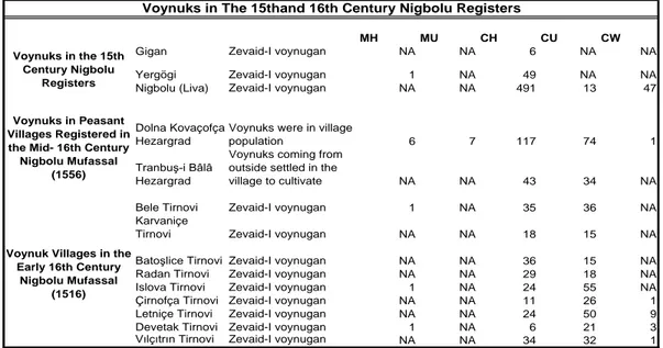
Table 3.3 Voynuks in The 15thand 16th Century Nigbolu Registers……... 76
Graph 3.1 Population of Old Settlements in the mid-16th Century……...…….. 77
Table 3.4 Changing Population and Status of Some Mezraas ………….………..78
Graph 3.2 Population of Urban Centers in Nigbolu Sandjak: From 15th to 16th Century………. 82
Table 3.5 Number of Ocaks in the Nigbolu Sandjak in the Mid-16th Century…….87
Table 3.6 Timar Holders in the 15th and 16th Century………..….89
Table 3.7 Typical Nomad Villages and Their Specializations in the mid-16th Century………..91
Table 3.8 In the mid-16th Century Nomads and Animal Husbandry in Pastures of Villages……….…… 92
Table 3.9 Family Size in Yörük Villages in the Mid-16th Century……….. 93
Table 3.10 Nomadic Obas and Divided Villages: From late 15th to mid-16th Century………...……… 96
Graph 3.3 Category I: Population of Old Villages in the mid-16th Century..……... 102
Graph 3.4 Category 2: Population of MuslimSettlements in the 1490- 1556 Period ………...… 104
Graph 3.5 Category 3: Haric-ez Defter Villages in the 1556 Survey..………. 107
Table 3.12 Zaviyes in the Central and North-Eastern Regions of the Nigbolu Sandjak in the mid-16th Century……….………..…...………….... 111
Table 3.13 Descendents of Sheikh Seyyid Timurhan……….. 112
Table 3.14 Examples of Newly Founded (Haric-ez defter) Villages in the Nigbolu Sandjak………... 119
Table 4.1 Cuman Names in Christian Districts of Nigbolu in the mid 16th Century……….……….. 155
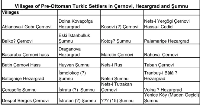
Table 4.2 Villages of Pre-Ottoman Turkic Settlers in Hezargrad, ġumnu and Çernovi... 159
Graph 4.1 Muslim and Christian Population in the Old Cuman Settlements in the mid-16th Century………. 160
Table 4.3 Turkic Names in the Early 16th Century Voynuk Registers of Bulgaria……… 166
Table 4.4 Examples of Turkic Names in Nigbolu……… 167
Table 5.1 Tirnovi in the Early 16th Century……….………...………. 181
Graph 5.1 Nefs-I Tirnovi ……….……… 187
Graph 5.2 Christian Villages of Tirnovi ……….………...………….. 188
Table 5.2 Muslim Villages in Tirnovi in the Early 16th Century………. 189
Graph 5.3 Muslim Villages in Tirnovi………...………..……… 190
1
CHAPTER 1
INTRODUCTION
Danube was a natural border between nomadic world of the north and settled empires since the Roman times. North-eastern Bulgaria had been a passage from Anatolia and Kipchak Steppes to Europe where climate and geography were appropriate for nomadic way of life. Northeastern Bulgaria with the foothills and low mountain ridges to the north of the Balkan Mountains constituted the historical hearth of the Second Bulgarian Kingdom (1185-1279). This region, including along the coast of Black Sea, had been a passage during the invasions of Turco-Mongol peoples such as Huns, Avars, Proto-Bulgars, Pechenegs, Kumans, Tatar- Kipchaks during the period between 5th and 13th centuries. Permanent settlements of these peoples had formed the foundations of Turkic presence in pre-Ottoman times in the region. The cultural, linguistic and administrative effects of the pre-Ottoman Turkic settlers were clearly seen in Ottoman registers, various achieve sources and
2
chronicles. Especially plains of north-eastern Bulgaria are a natural extension of the steppe region and even in the Ottoman era, nomadic way of life, strong tribal ties and strategic location on the Danubian border was the main characteristics of the Nigbolu Sandjak.
History of the region until the Ottoman conquest is a part of Byzantine history of invasions and uprisings on the Danubian border stated in the Byzantine chronicles and travel accounts but after the Ottoman conquest, very detailed cadastral surveys were made and there are the primary archival sources of demographic, social, religious, economic, financial, administrative and political history of the region and these surveys dated to 15th and 16th century are kept in Ottoman Archives in Istanbul and Sofia. A tahrir defteri, in other words “tax-survey” or “tax register” is a general survey of taxable economic and financial sources generally made either when a new sultan ascended the throne or after a new conquest. These surveys compiling to serve the military and administrative system of the empire are rich and valuable sources of information of a specific geographical area. 1 The earliest Ottoman tax survey was transcribed and published by Halil İnalcık with a detailed introduction about the important archival sources in 1950s. Ömer Lütfi Barkan is the other important scholar who examined tahrir registers and his articles published in Turkish and
1 See: İnalcık Halil ,Hicrî 835 Tarihli Sûret-i Defter-i Sancak-i Arvanid (Ankara: Türk Tarih Kurumu, 1954), XXI-XXXVI; on usage of tahrir defters as historical sources see, Halil İnalcık, “Ottoman Methods of Conquest”, Studia Islamica 3 (1954): 103-129.
3
European languages.2 In the 1990s, Mehmet Öz, Heath Lowry, Kemal Çiçek published articles underlining methodological problems in using the tahrir defters as a source of historical databases.3
Although there are some Byzantine practices (detailed population and tax statistics) for the other regions of the Balkans, the earliest archival sources of the Niğbolu are the two Ottoman Niğbolu icmâls (summary of a detailed registers) kept in Sofia Archive.4 These two icmal registers dated to the last quarter of the 15th century, circa 90 years after the conquest, give information about names of timariots, number of soldiers that these timariots had to train, tax revenues, names of villages and mezraas that the timariots holding, the number of Muslim, Christian, yörük and other settlers of these villages, their privileges and tax- exemptions. Also, there are some der-kenars explaining if there were any change in the timars, villages and statuses of the peasants. In this period, formation of Ottoman social, military and
2 See, Barkan, Ömer Lütfi “Tarihî demografi araştırmaları ve Osmanlı Tarihi.” Türkiyat Mecmuası 10 (1951-1953): 1-26; “Research on the Ottoman Fiscal Surveys”, Studies in the Economic History of the Middle East, Michael A. Cook (ed.), (London, 1970), 163-171; “Essai sur les données statistiques des registres de recensement dans l’Empire ottoman aux XVe et XVIe siecles”, Journal of Economic and Social History of the Orient, 1/1 (1957): 9-36; “Quelques remarques sur la constitution sociale et demographique des villes balkaniques au cours des XVe et XVIe siècles”, Istanbul à la jonction des cultures balkaniques, mediterranéennes, slaves et orientales, aux XVIe-XIXe siècles (Bucarest, 1977), 279-301; Barkan Ö.,L., 1988. Hudavendigâar Livasi Tahrir Deftei I, Ankara:Türk Tarih Kurumu Yayınları.
3
See Öz Mehmet, “Tahrir Defterlerinin Osmanlı Tarihi Araştırmalarında Kullanılması Hakkında Bazı Düşünceler”, Vakıflar Dergisi 12 (1991): 429-439; Lowry, Heath W., “The Ottoman Tahrir Defterleri as a Source for Social and Economic History: Pitfalls and Limitations”, in Lowry Heath W., Studies in Defterology. Ottoman Society in the Fifteenth and Sixteenth Centuries (Istanbul: Isis Press, 1992), 3-18; Kemal Çiçek, “Osmanlı Tahrir Defterlerinin Kullanımında Görülen bazı Problemler ve Metod Arayışları”, Türk Dünya Araştırmaları 97 (1995): 93-111;
4 Sofia, Oriental Depatment of Bulgarian National Library “St. St. Cyril and Methoius”, Or. Abt., Signature OAK., 45/ 29; Sofia, Oriental Depatment of Bulgarian National Library “St. St. Cyril and Methoius”, Or., Abt.,Signature Hk., 12/9
4
financial system in the region had still been in process and these surveys were the most important financial documents to be aware of all taxable resources, timar lands and idle economic resources to internalize them in the Ottoman system. For this reason comparison of these earliest icmals indicate continuation of the former system and changes introduced by the Ottomans during the first century of the conquest.
The earliest survey is dated to 1479 consists of 60 pages with missing
kanunname part at the first pages and the wakf registers at the end pages. For this
reason, kanunnames and wakf registers of the 16th century Nigbolu tax-surveys are the complementary archival materials for the study. The 1479 register is a icmal register that was basically kept to register the names of timariots, the villages in each timar and the tax revenue of the timatiots. There is 19 zeamets and 220 timars were in the register. In this survey, a vast majority of the village are double named as Greek and Slavic named or Slavic and Turkish named. In the 16th century surveys, Turkish name or Slavic name becomes the only name in the registers of double named villages in the defters and for this reason these earliest register is crucially important for the pre-Ottoman history of the region. The second register is not dated but this tahrir is most probably made in the last two decades of the 15th century. The paper of the register and its writing style indicate that the survey was registered in the 15th century. There are very much common information such as demographic data and names timariots and amount of tax revenues with the 1479 register. The second register is an icmâl register with missing parts at the beginning and the end of the
5
defter as well. All these indicate that date of the tahrir is most probably 1480s. For this reason, while we are examining the second register, we assume the date of the
tahrir as 1483. There were almost a hundred timar were registered in the survey and
10 of them were zeamet.
This study examines land and military surveys of the 16th to analyse the second stage of the Ottoman rule in the Nigbolu Sandjak. Two mufassal registers, TD382 Nigbolu Mufassal Defteri (1556) and MAD 11 Nigbolu Livasi Mufassal Defteri (1516) are the detailed surveys and the two voynuk surveys, TD81 defter-i voynugan sene 929 (1522-23) and TD151 defter-i voynugan sene 935 (1528-29), are military surveys used in this study comparably. This study examines Çernovi, Hezargrad and Şumnu regions among the kazas of the Nigbolu Sandjak registered in the TD382 mufassal register. There are 70 hassa, 18 zeamets and 159 timars are registered in the TD382 mufassal register of the Nigbolu Sandjak. This survey indicates that there were many changes in status of villages. There were 17 new hass lands (hassa-I cedid), many new derbend villages among the 32 derben villages, 71 new villages (haric-ez defter), which indicate a new era and a different re-structuring policy on the Danubian region. On the other hand, pre-Ottoman lesser military nobility adapted to the Ottoman provincial army, their fief lands, their organizations and even their uniforms had been the same since the pre-Ottoman times.5 Voynuk and toviçe settlers in many towns, new and old villages, timar holder voynuks and toviçes were registered in the survey, among which many pre-Islam Turkish names
5
6
indicate Turkic members of these organization of Christian soldiers. Also pre-Islamic Turkish names registered in Christian villages and Christian districts of the urban settlements are good exaples for the pre-Ottoman Turkic settlers of the region. The mid-16th century detailed register of the region is a valuable source onomastic, demographic, military, social and religious history of the Danubian border. The other defters of the Nigbolu Sandjak are MAD 11 Nigbolu Livasi Mufassal Defteri (1516) and the two voynuk surveys, TD81 defter-i voynugan sene 929 (1522-23) and TD151 defter-i voynugan sene 935 (1528-29) and these sources are the main archival documents of the pre-Ottoman Bulgarian higher nobility, Christian soldiers adapted to the Ottoman army and their organizations. MAD11 is the earliest detailed register of Tirnovi region, which was the capital city and military center of the Bulgarian Kingdom and the voynuk defters TD81 and TD151 are the earliest surveys of the military organization consists of a valuable onomastic data base on the voynuks and a detailed register of their hereditary fief lands (bashtinas) that they were holding since the pre-Ottoman times. These mufassal and military surveys are the unique archival sources of this study in which a detailed and objective data on demography, institutions, ethnic and religious composition of both the former Bulgarian capital, Tirnovi, and the organization of Christian soldiers, voynuks. These early 16th century defters register descendents of the pre-Ottoman military nobility even with some family names and the Christian soldiers incuding many Turkic steppe warriors name by name.6 These primary sources consisted the backbone of this study and many other secondary sources discussed in detailed in the chapters
6
7
helped this study to ask research questions and explores the answers or new directions to explain the transformation and continuation in the Danubian border in the post conquest era and the long period of war and struggle in the 16th century.
1.1. Measurement of Demographic Data
Population changes in the Nigbolu Sandjak during in the period, 1300-1600, mainly depended on natural conditions, infectious diseases, wars between Ottomans and the anti-Ottoman alliances of Christian states, and waves of mass migrations from Asia Minor. In the pre-industrial societies, expected life time hardly exceeded 35 years old and death rates, especially infant and child mortality, were higher than in the most of the poor regions of the world today. Sharp changes in death rates, sudden and devastating declines in population were common results of epidemics such as Black Death periodically threatened the city dweller of Europe and long and bitter winters, drought years and famine deeply affecting the geographical variations of death rate. Compare to the cities pre-empting whatever was available and obtainable, villages were probably more likely to suffer from bad natural conditions and poor harvest. Also, loss of agricultural labour force in military campaigns was one of the main reason behind sharp demographic changes. Significant loss of labour force, not only in terms of soldiers but also in terms of civil population, taking refuge of inhabitants in safer regions were unavoidable results of continuous wars and
8
destructions especially in frontier regions.. When such conditions of the pre-industrial times are considered, many fluctuations with regional upward and downward demographic shifts in population should be considered an integral part of the demographic history of the Danubian border.
When one would like to analyze demographic structure of the Ottoman lands, the related material in the archives will provide valuable information about the demography of the pre-industrial society not only in the near and middle east but also in the Eastern Europe.7 In order to determine the demographic structure and changing trends in different time periods, researchers used different approaches to examine these rough demographic data in these surveys. One of the approaches is “population multiplier”. In this method, a constant multiplier for a typical hane (household) is determined, which is an assumption made on the average family size for a period of time in a specific geographical area. For instance, in Europe, researches documented wide variations in the size of household among different geographical areas over time. The range in England was in between 4 and 7,5 and in Belgrade in 1733-4, mean of the multipliers is between in 11,4 and 5,46.8 Barkan is one of the researchers who analyze Ottoman tahrir defters to determine the pattern of population increases in the sixteenth century. 9 According to Barkan, the number of married individuals comprising an avariz hanesi might vary between 3 and 15. 10
7 For the previous works and discussions on the Otoman demography see Erder (1975); Erder (1979); Cook (1972); İslamoğlu-İnan, (1987); İnalcık (1978); İnalcık (1986).
8 For more information see, Laslett (1971) and Freche (1971). 9 Barkan, (1970), pp. 168-169.
10
9
Cook also made a study on three livas in Anatolia and used the hane multiplier as 4.5.11 According to the other study estimating a hane multiplier made by Coale and Demeny, all multipliers estimated are confined to relatively narrow range varying between 3 and 4. 12
When a hane multiplier is determined for Ottoman Niğbolu in 15th century, the gap between native Christian and immigrant Anatolian population should be the first determinant taking into consideration. Although Anatolian nomads, yörüks, were the most populous Muslim group on the sandjak and family size of these nomad household was the largest even among the other Muslim households in the region, A vast majority of the population in the sandjak was native Christians taking refuge in urban areas or temporarily living in a safer settlement other than their former villages. When the unstable political conditions, continuous wars, and displacements in the region during the pre-Ottoman period are taking into consideration, the household multiplier of the native Christians in the Niğbolu Sandjak during the last two decades of the 15th century might have been in between 3 and 4. However because of the appropriate living conditions in Anatolia and the self-sufficient life style of Muslim Anatolian nomads depending on human resource to be maintained, hane multiplier for the Muslim population of the sandjak should be determined higher than 4. When cooler climate of the northern Bulgaria is considered, the household multiplier of a typical Muslim household should be lower than in
11 Cook (1970). 12
10
Anatolia. For this reason while examining the population in the sandjak, the household multiplier is going to be as 4,5, which is an average value of family size for both Muslim-Turks and native Christians living in the sandjak.
1.2. Niğbolu as the Gate of Danubian Frontier Region
Since the reign of Bayezid I (1389-1402), Danube was the northern border of the Ottoman sovereignty in the Balkans and this imperial policy became a tradition for the successors of Bayezid I. In the reign of Murad I (1362-1389), the Ottoman Balkans became a separate military and administrative region under the rule of a
beylerbeyi. Danubian frontier on the south bank of the river was a strategically
important defence line of Ottoman Bulgaria. There were three frontier sandjaks in the region: Silistre, Niğbolu, and Vidin. In the pre-Ottoman period, fortresses were key defence points for invasions and attacks coming from the north. For this reason tax registers, especially the earliest ones reflect the pre-Ottoman military and administrative system of the border. As a rule, the Ottomans maintained pre-conquest administrative division of the newly conquered lands as well as former military and financial customs and traditions. For instance, after the conquest, The Ottomans incorporated the borders of the divided Second Bulgarian Kingdom and these lands were organized as separate sandjaks such as Shishman’s kingdom as Niğbolu
11
Sandjak, Kingdom of Ivan Starcimir as Vidin Sandjak and independent Oguz State in Dobrudja incorporated with the south-eastern part of the Shishman’s kingdom formed the Silistra Sandjak. Also Rusçuk (Russe) became an important city, a port, and one of the four castles of the Danubian defence line with Şumnu, Varna, and Silistre. Along the northern border, Rusçuk was the most important military defence point on the Danube in case of any attack that could threaten Edirne and the Ottoman Capital, Istanbul.
1.3. Geography, Climate and Nomadism
The lands of the Ottoman Empire from Persia to the Balkans were one of the five major geographic areas of the pastoral nomadism in the world. Danube was a natural border between nomadic world of the north and civilized empires since the Roman times and the invasions of nomadic tribes of the steppes did not stopped until the 13th century.13 Balkan region had been a passage between Anatolia and Kipchak Steppes 14 where climate and geography were appropriate for nomadic way of life. Especially plains of north-eastern Bulgaria were a natural extention of the northern steppes and since the ancient times, settlers of these lands had been tribes of the steppe region. Bands of high and low terrains extending east-west direction across
13 For more information on Danubian border and Dobrudja see, İnalcık, “Dobrudja”, EI, p. 610; also see, Machiel Kiel, The Türbe of Sarı Saltık at Babadag-Dobruja, Güney Doğu AvrupaAraştırmaları Dergisi, 6-7, 1978, pp. 205-225.
14 The main nomadic regions in the world are Africa south of the Sahra, Arabian Desert, Anatolia, Euroain Steppes and Tibet Plateu. See, Thomas Barfield, The Nomadic Alternative,Prentice Hall (1993), p. 7.
12
the country are the main characteristic of Bulgaria’s topography.15
The Balkan Mountains following the Danubian Plateau in the extending to the Black Sea are higher and hilly regions encompassing the lands between the northern border along the Danube and the Balkan Mountains drawing the southern border of the region. After the fertile plains on the shore of Danube, higher pasturelands on the hills of the Balkan Mountains limiting the arable lands are the ideal regions for the transhumance nomadic life since the ancient times. Besides the topographical conditions, climatic conditions make the northern Bulgarian plain, Danubian Plateu, different than the southern part of the country. The Balkan Mountains have a strong barrier effect felt throughout the country, especially in central and eastern parts of the Danubian Basin, where strong influence of continental climate is a characteristic of the region. High annual precipitation on the Balkan Mountain chain with cooler summers and while very hot in summer and drought weather during year on the lowlands of the southern Balkan range is very typical climatic conditions in the region. In the region, plains of Danubian Plateu and Dobrudja are often subject to summer throuhts but mountains and high pastures of the Northern Bulgaria are cooler and rainier through year. Althouh valleys open to milder effects of the south along the Agean and mediterranean coasts providing warm shelters for the nomadic life,
15
For the Bulgarian historical geography see, Lyde Lionel W. and Mockler-Ferryman A. F. 1905. A military geography of the Balkan Peninsula .London; Wace A.J.B. and Thompson M.S. 1972. The nomads of the Balkans : an account of life and customs among the Vlachs of northern Pindus. New York: Biblio & Tannen; A. and C. Black, 1905. Orachev Atanas. 2005. Bulgaria in the European cartographic concepts until XIX century. Sofia : Borina; Rizoff Vorwort von D. 1917. Die Bulgaren in ihren historischen, ethnographischen und politischen Grenzen. Berlin: K. Hoflithographie, Hofbuch- und Steindruckerei Wilhelm Greve; Fasolo Michele. 2005. La via Egnatia. Roma : Istituto Grafico Editoriale Romano; Batty Roger. 2007. Rome and the Nomads : the Pontic-Danubian realm in antiquity. Oxford : Oxford University Press;
13
especially the coast of Danube is bitterly cold and windy winters. These topographic and climatic conditions explain the strong effects of the nomads and transhuman life-style in the region. Central and north-eastern Bulgaria, Deliorman and Dobrudja are areas keeping the different settlement patters and various pre-modern ethnic and cultural elements together in the region. Since the ancient times, nomads coming from the northern steppe region and Asia minor brought different types and stages of nomadic life-style to these lands. However difficulties to obtain archaeological or even written historical sources limit the researches in rural history of the region.
1.4. Conquest of Nigbolu
Ottoman conquest of Bulgarian started in the reign of Murad I after the conquest of Edirne in the spring of 1361.16 Evrenos Beg captured İpsala. (Kypsela)
castle and after the death of Orkhan Bey, Murad I appointed Lala Şahin as beylerbeyi of the udj begs in the Trace.. After Lala Şahin’s capture of Eski Zagra and Filibe, Sultan Murad went on a campaign to make new conquests in the Balkans in 1366. and in the same year, Filibe became the udj center of Lala Şahin who extended the raids on the direction of Sanakov and İhtiman. During an alliance made between Tzar of Bulgaria and Ottomans against Byzantine stopped the Ottoman advancements in the Bulgarian lands for some time but this alliance did not last very long.
16
14
Amadeo VI of Savoy who is the cousin of the Byzantine Emperor John made an agreement with the Bulgarian Tsar Alexander and some Bulgarian castles were given to Byzantine, which ended the Ottoman-Bulgarian alliance in 1366 and after that time, Bulgarian lands became the target of the Ottoman akindjies. The Sultan Murad I begun his conquests in spring of 1368 and he firstly captured strategic settlements and fortresses in the passes on the Balkan mountains such Aydos (Ateôs) and Karin-Ovası (Karnobad). Sozopol, Pınar-Hisar, Kırk-Kilise and Vize were the other strategic conquests. In 1368-69, Ottomans captured of Kızilağaç-Yenicesi (Elhovo) and Yanbolu (Yamboli) and Lala Şahin’s conquests of Samakov and İhtiman on the via militaris opened the way of Bulgarian capital Sofia for the Ottomans. In 1370, Lala Şahin won the Sarıyar battle and the people living in Rila mountain-region accepted to obey the Ottoman rule. After the Sırp-Sındığı war in 1371, Turkish dominance strongly felt in the region.17 In winter 1372, Byzantine became one of the vassals of the Ottoman State18 and Bulgarian Kingdom following the Byzantine accepted the Ottoman suzerainty in 1375-76 19. Within a few years, Kavala and Serez were captured and Serez became udj center of the akindjies.
When Bulgarian Tsar Shishman and ruler of Dobrudja made alliance with the rebelled Serbian Prince Lazar, Ali Pasha and Timurtaş Beg marched on Bulgaria and Dobrudja. The captured fortified city Shumen became the military center of Ali Pasha’s raids. King Shishman had to move his center from Tirnovo to Nikopol
17 Jirecek (1876), pp.439, cited by İnalcık, “ I. Murad”, DIA, p. 9. 18 İnalcık, “ I. Murad”, DIA, p. 9.
19
15
against the Ottoman raids and when Bayezid I captured Tirnovo, Dobrudja and Silistre in 1393, Nikopol remained as the only fortification of the vassal Bulgarian State resisting to the Ottomans. Niğbolu was the fortress famous with the battle between the Ottomans and the Crusaders on 25 September 1396. One of the important results of the Ottoman’s victory was the Ottomans’ suzerainty on Wallachia that was a strategic ally of the western Christian world against the Ottomans. A relatively long peace period following the battle, gave the Ottomans enough time to establish Ottoman military, fiscal and administrational system in Bulgaria.
1.5. Ottoman Rule in the Nigbolu Sandjak
1.5.1 Timars and Timariots
Timar system was the backbone of the Ottoman Empire and its system immediately introduced in newly conquered lands. Sipahies were generally chosen among kuls of high ranked military bureaucrats such as kuls of Pashas, sons of government officials such as veled-I an çavuşân-ı mir-i miran, and members of military class such as merd-I kal’a, voynuk, toviçe. Timariots were generally Muslim members of the Ottoman system but especially in the early Ottoman era, many
pre-16
conquest local nobles were registered as timariot.20 In the 15th and 16th century Nigbolu surveys, there are some Muslim and new-Muslim timariots whose father was Christian such as Şahincibaşı Yakup veled-i Zupani and Umur veled-i Hızır Bey veled-i Dalgofça holding timar in the late 15th century and Mustafa bin Abdullah holding timar in the mid-16th century. As Graph 1.1 shows that timar was an efficient way of paying salaries of government officials as well and there were many civil bureaucrats in the 15th century survey as timar holders such as kadi, iskele emini, and hatip. Also zeamet-i Lofça given to Hızır Bey, zeamet-i Gerilova given to Ramazan Bey, zevaid-i voynugân-ı Niğbolu given to Mahmud Bey as, and zeamet of nefs-i Çibre given to (Mihaloğlu) Ali Bey indicate akindji Beys and their big timars in the Danubian border periphery.
20 İnalcık, Halil, “Stefan Duşan’dan Osmanlı İmparatorluğuna: XV. Asırda Rumeli’de Hristiyan Sipahiler ve Menşeleri”, in Osmanlı İmparatorluğu: Toplum ve Ekonomi, (İstanbul: Eren Yayınları, 1993).
17
1.5.2 Native Christians: Migrations, Deportations, Population
Pre-conquest era had been a long period of wars, destructions and continuous displacements in the region. The unbalanced distribution of population between urban and rural settlements of the Nigbolu region even after a century following the
Table 1.1
Government Officials Holding Timar in the late 15th Century
Village Timar Holder Revenue
Novasil
Tırnovi Timar-I kadi-I Tirnovi 4700
Kalotençe Tırnovi
Mevlana Muslihiddin
hatib-i cami-i Tırnovi 2700 Dobrika Tirnovi Kara Molin Tirnovi
Kâtib Sinan emin-i
İskele-i Niğbolu 4254
Sopot
Tırnovi Muhiddin emin-i iskele-i Silistre 6190 Kalu
Grova
Kurşuna Virdun Mz
Çernovi
Source: Sofia, Oriental Depatment of Bulgarian National Library “St. St. Cyril and Methoius”, Or., Abt.,Signature Hk., 12/9
18
conquest indicates that peasant population of rural settlements had been taking refuge in the fortified big cities, towns and derbend villages. Recovery of the rural settlement system and re-population of the abandoned villages and mezraas would be a long process taking almost a century. Information notes in the 15th century surveys of the region states that settlers of many villages were registered in other villages, which could be settlements close to the big cities or fortifications. On the other hand, deportation was a practical policy tool of the Ottoman central authority and displacements was always made because of various reasons. 15th century registers indicate that Native Christians of some big towns such as nefs-I Çibri and villages such as Kalugerevo were deported to the newly conquered Constantinople most probably in the reign of the Mehmed II. For this reason re-population was an urgent problem for the Ottoman central authority during the first century of the Ottoman rule in Nigbolu region.
One of the most significant elements of native Christian population was widow woman chift holders (bîve), which was 6% of the total Christian population registered in the late 15th century and even in the mid-16th century; bîve households were registered in only Christian settlements. Chift land of a hane could be given to the widow until his son or sons grown up. Central government preferred to give chift lands to widows but a sipahi wanted to sighn a new rent contract with a new peasant to get a rate of money as “ resm-i” tapu. There were ot any explanation about the high number of bîve households but traveler account states When seeking an
19
explanation for the bive issue, we should refer to travelers. Travel notes of the Austrian traveler Stephan Gerlach visited the region in the 16th century during the reigns of Selim II and Murad III.21 According to Gerlach, in order to give priority to the unmarried girls, Orthodox priests did not give permission to widows for a new marriage. The reason behind the negative attitude of Orthodox priests towards the second marriage of a widow was most probably not religious but demographic. There was a gap between the rate of man and woman population in 15th century Niğbolu, which should be a result of poor life expectancy, epidemics and continuous wars changed the demographic balance of men and woman in the region. For this reason priests gave priority to unmarried girls in marriage, so there was such a big number of widow registered in the region.
There was a long peace and stability period after the conquest and return of rural population to their former settlements had already started in the late fifteenth century, which changed the demographic balances in the sandjak in favour of rural settlement regions. On the other hand, comparison of two earliest registers indicates that there was a significant increase in number of Christian household in the rural settlements and a new settlement trend, divided villages as Gorna (lower) and Dolna (upper), changed the existing settlement network. Population increase in villages led the new households to go and settle appropriate lands around the village. After some time, these new settlements became villages bearing the same name with the old village. These two villages were distinguished from each other by adding an
21
20
adjective in front of their name, Dolna or Gorna such as Dolna and Gorna Krayişte, Dolna and Gorna Beşovitçe, Dolna and Gorna Kremene. are examples for such villages. For this reason, these registers can be clear evidences for a general population increase in Christian villages. On the other hand this trend did not continue in the 16th century and consistent stability of the local Christian population was kept in the central and northern regions of the sandjak.
There were not a significant population movement of native Christian settlers of the sandjak in the 16th century but “preselechs” were registered in almost every rural Christian settlements, towns and cities. Preselech is a Slavic word which means “immigrant” and most probably it was used as a term referring to newcomer Christian peasants. Registers were not clear whether these were household or unmarried but son of a preselech was registered as an ordinary peasant household in the village.
In the fifteenth century, a quick and mass-Islamization did not a reality seen in the registers of either in the 15th or 16th century military and tax surveys in the sandjak. When demographic information of late fifteenth and mid-16th century surveys are compared, it is seen that population was predominantly Christian. Also military registers of the early 16th century indicate that covers ion to Islam not more than some individual cases among the Christian members of the military class.
21
1.5.3 Bogomils in Ottoman Nigbolu
Bulgaria was the center of heterodoxy and pagan elements of Slavic and Turkic cultures had bee na part of the religious life. Since the 10th century, Bogomilism became the symbol of resistance in Bulgaria against the dominant image as well as strong cultural and religious hegemony of the Byzantine Empire. Bogomils were mostly peasants and their masters, Bulgarian boyars. For this reason, Christianization efforts of Constantinople on Bulgarians resulted with resistances of the native Bulgarians during the centuries under the Byzantine rule., for which a new religious sect born in Bulgaria, Bogomilism, found many supporters in the Balkans. Orthodox patriarchs considered Bogomilism as a heresy and Byzantine struggled with the heretics to prevent spread of their ides in the Balkans but Bogomilism was being alive in Bulgaria as a resistance to the cultural dominancy and oppressive religious policies in Bulgaria.
Obolensky defines Bogomilism as the outcome of the fusion between these dualistic heresies and the Slavization in the region.22 In the tenth century, new heretical movements appeared in the in Bulgaria. There were two main sources for these new heretical movements: teaching of Paulicians–Massalians and spread of pagan culture and beliefs of Slavic culture.23 The earliest document of the religious transformation in Bulgaria is a letter of Peter, the king of Bulgaria, to patriarch
22 An English translation of the letter was published by V.N. Sharenkoff in his book A Study of Manrehaeism in Bulgaria, New York (1927).
23
22
Teophylect of Constantinople. The letter is not dated but it is predicted as in the period 940-950. Peter, in his letter defines the heresy as “Manichaeism mixed with Paulicianism” informed the Patriarch and asked his help and guidance. 24
Priest Bogomil was first thought Bogomilism in Bulgaria during the reign of Peterthat A 13th century Bulgarian Document, the “Synodicon of the Tsar Boril”, confirms this information.25 Bogomilism found many supporters among the native Slavs in Bulgaria. Bogomilism perceived as a reaction against Christianity being the symbol of the cultural and religious domination of Byzantine. Although native people of Bulgaria Christianized, they had kept their pagan beliefs and culture alive for centuries.
Liberal religious policies of the Ottoman State until the end of Bayezid II’s reign created a free religious medium in the Ottoman Balkans and populous Bogomil villages registered in Niğbolu sandjak in the last quarter of the 15th
century. There are five Bogomil villages are Brestovice-i Pavlikan (Lofça), Kalugeriçe-i Pavlikan (Lofça), Oreşan-i Pavlikan (Niğbolu), Telej-i Pavlikân (Lofça), Trınçeviçe-i Bulgar and Pavlikân (Niğbolu). Names of these villages indicate the categorization of these settlements such as Bulgar used for Orthodox village and Pavlikân used for Bogomil village. Some of these villages such as Trınçeviçe-i Bulgar and Pavlikân were registered as hisse and other hisse or hisses was not registered, so Bogomil population in these settlements is unknown but comparison of two 15th century
24 Sharenkoff in his book A Study of Manrehaeism in Bulgaria, New York (1927) pp.63-65. 25 This document was published by J. A. Ilič in his book Die Bogomilen in Ihrer Geschtlichen Entwicklung (Sr. Karlowci, 1923)p.18 cited by Obolensky, Dimitri (1972), pp.118.
23
registers indicates that the Christian households of Brestovice-i Pavlikan (Lofça) decreased from 40 to 12 and 1 unmarried man was added while the Christian hane of Kalugeriçe-i Pavlikan (Lofça) was increasing from 39 to 53 and 9 unmarried men was added. Both of these villages were in Lofca and it was most probably an internal migration from one Bogomil village to another.. Demography of the other two Pavlikan villages, Oreşan-i Pavlikan (Niğbolu) and Telej-i Pavlikân (Lofça) were stable during the period between the two tahrirs in the 15th century.
1.6 Town and Village System in the Ottoman Nigbolu
Nigbolu as was one of these frontier sandjaks located at the central-northern region of the Ottoman Bulgaria. The sandjak was divided into kazas as Niğbolu (Modern Nikopol as the center of the sancak), Ivraca (Vratsa as its center), Lofça (the town of modern Lovech as its center), Tırnovi (the town of modern Veliko Tirnovo as its center), Şumnu (modern Shoumen as its center), and Çernovi (the modern village of Cherven, in the district of Rousse). 26 Besides these kazâs, there were
nahiyes such as Rahova, Çibri, Reslec, Nedeliçko, Plevne, Kurşuna, Kieva, İzladi,
and Ziştovi. Medieval ports and fortified centres along the Danube such as Niğbolu, Ziştovi, Tutrakan became parts of nahiyes and kadi centers after the conquest and rise of Ruschuk (Giurgiu or Yergögü ) on the right bank of the Danube was not earlier
26 Kovachev, Rumen. (2005) Nikopol Sancak at the Beginning of the 16th century According to the Istanbul Ottoman Archieve, Osmanli ve Cumhuriyet Dönemi Türk-Bulgar İlişkileri, Osman Gazi Üniversitesi Tarih Bölümü Eskişehir Uluslararası Sempozyumu. Eskişehir, 65-67.
24
than the 17th century. The town of the old capital, Tırnovi, also maintained the leading role in internal division among the central nahiyes such as Tuzla, Sahra, and Hotaliç. In the west, Lofça, Ivraca, Resleç, Nedeliçko, Kurşuna and Plevne were important centers in administrative division of the sandjak.27 Many of these kazas and nahiyes were recognized as kaza centers and many other kazas and nahiyes were unified or divided to provide an efficient administrative system. For instance, in the west, the nahiye of Karalom was re-organized as Çernovi and the kaza of the future Hezargrad (Razgrad) and the kaza of Şumnu was internally structured into Gerilovo.28
1.7 Ottoman Social, Economic and Military System in the Sandjak
The peasant household cultivating and managing a piece of agrarian land was a farm unit since the late Roman Empire. The peasant family unit was called as
colonus in Roman, paroikos in Byzantine and raiyyet in Ottoman system. This family
unit remained the “basic cell” of the rural society for tousands of year. Arable lands were mîrî , which means under state ownership, which strengthen the governmet control on these lands and maintained the system as the basis for the agrarian and
27
Kovachev, Rumen. (2005) Nikopol Sancak., 67.
28Kovachev, R., Rumen, Nikopol Sancak at the Beginning of the 16th century According to the Istanbul Ottoman Archieve, Osmanli ve Cumhuriyet Dönemi Türk-Bulgar İlişkileri, Osman Gazi Üniversitesi Tarih Bölümü Eskişehir Uluslararası Sempozyumu (2005), p. 67.
25
fiscal organization of the state.29 A peasant family was a perpetual tenant on a piece of agrarian land, which gave hereditery rights of posession through the direct male line. Ottomans adapted these inherited old practices of the Roman and Byzantine empires to the principles of Islamic law and the Islamic state tradition of the Middle East.
According to the Islamic law, conquered lands were common property of Islamic state and in principle, owner of all arable lands was state.30 Ottoman central authority formed Çift-hane system on these state-own arable lands based on thee basic elements: a peasant househol (hane), a certain unit of land (Çiftlik) and a farm workable by a pair of oxen. These elements were the basis of the Ottoman fiscal, military and agricultural system. In such a system, a çiftlik should be large enough to maintain the peasant-family, to yield sufficient surplus to pay taxes, to cover reproduction costs and to survive the family during the year. Adult male labor force was the basis of the çift-hane system and the tax paid by the adult male did not depend on whether the other members of the family participating to the agricultural activities possessing a piece of land or not. The main criterion for the tax was marital status such as married, unmarried, or widow.
29
See İnalcık (1994), p.145-146.
30 See Abu Yusuf Kitab al- khradj, Bulak. Turkish Trans. By Ali Özek, Kitab-ül Haraç, İstanbul,( 1884) p. 23-27, 28-39, and 52-58; Morony, Land- Holding in the seventh century Iraq:Late Sasanid and Early Islamıc Patterns, in Udovich ed., pp., 135-175.
26
In Ottoman çift-hane system furtility of soil was the criterion determining the optimal farm size, which was changing from 5 to 15 hectars.31 In principle these indivisible çiftlik units were registered on an adult male and the tax levied on the land was resm-i çift. In Slavic provinces, the farm was called as bashtina and the tax collected from the hane, resm-i çift, was named as ispençe. When the died adult male left an son, the çiftlik was temporarily taken away from the son until he became mature. In this case, as an Islamic attitude, the bive (widow of the adult men) could retain possession of the land registered on his husband and she cultivated the çiftlik and paid the taxes until her son reached maturity. In Ottoman registers, bive was recognized as taxpayer. The law required that a peasant family possessing a full
çiftlik paid one gold piece (or 22 akça in silver coins) and half-çift (nim-çift) paid12
akça. A family posessing less than a half çift was called as bennak and the land-tax for this family was 9 akça. If the peasant was unmarried or widow, the tax that had to be paid was 6 akça.32The other name of resm-i çift was kulluk akçası.33 The term,
Kulluk, defines a status of being dependant or subject. In this case the tax was levied
on the cash equivalent of such feudal obligations, which was a big revaluation breaking the feudal tradition of the Balkans. On the other hand, kul was a term in the 15th and 16th century tahrirs of the Nigbolu Sandjak implying a slave origin and slave
31
Barkan (1943), index çiftlik. 32 See İnalcık (1994), p.149.
33 Halil İnalcık states that Ottomans put pre-Ottoman feudal obligations together under one tax called resm-i çift or kulluk akçası. Ottoman law-codes recorded the tax as 22, 12, 9,6 akça, which are the cash equivalent of the peasants’ obligations to their land-lord. These obligations were 3 akça for three days’ personel services, 7 akça for providing a wagon-load of hay, 7 akça for half a wagon-load of straw, 3 akça for a wagon-load of firewood, and 2 akça for service with a wagon. According to the law-code of Mehmed the Conqueror the total amount paid instead of these seven services was 22 akça. See İnalcık (1959), p.581.ocan
27
labor force on agrarian lands. There are many registers of empty lands given to timariots to be populated in both 15th and 16th century Nigbolu surveys and these timariots were expected to find reaya (peasants) who was going to cultivate these lands and pay tax. Sometimes these reaya could be enslaved native people in war, who were settled on empty lands as ortakçı kullar and in time, they became free peasants holding çift (farm) lands given them under tapu (Çift-hane ) system. 34
During the classical age (1300-1600), well-defined family farm unit was the basic element of the agrarian economy in the medieval times and Ottoman Empire successfully adjusted and maintained the system to establish a well-functioning order of the central authority in the conquered lands. Successfully maintenance of the land system is one of the reasons behind the long-lasting Ottoman State.
1.8 Scope and Focuses of the Study
This study aims to examine changing ethnic, cultural, religious, and political structure of the Nigbolu Sandjak that had already started in the 15th century but accelerated in the first decades of the 16th century, when the a long period of war started on the Danubian frontier. After a process of demographic recovery, re-structuring of administrative, military, financial, economic and social system in the 15th century, the Ottoman rule in Nigbolu Sandjak in the 16th century was the period
34 Barkan, “On beşinci asırda Osmanlı İmparatorluğunda Toprak işçiliğinin Organizasyon Şekilleri: Rumeli’deki kulluklar ve Ortakçı Kullar”, İktisat Fakültesi Mecmuası, c.1, s. 4 (Temmuz 1940), s.124-125.
28
of revolution and transformation, tradition and continuation on the eve of a new era for the medieval empires.
The first chapter of this study is going to examine the late 15th century surveys of Nigbolu Sandjak, which were the earliest cadastral surveys of the region. These archival sources include registers of various groups of settlers such as Muslim, non-Muslim, Anatolian nomads, Muslim and Christian members of provincial army and members of various military organizations. This chapter also focuses on old and new settlement pattern of the region and re-population process of abandoned Christian villages as well as changing military organization, timar system, profile of timariots and the process of building a new system based on the existing state tradition of Byzantine Empire and the Second Bulgarian Kingdom, which was the first phase of the complex, well- organized and institutionalized formation of the Ottoman system in the sandjak.
The second chapter exaimes the 16th century mufassal registers, which are the most detailed archival sources of the sandjak the consisting onomastic, statistical, financial and administrative data of the Nigbolu Sandjak and explores the dynamics and forces behind the second phase of demographic, social, political, military and administrative formation of Ottoman system the sandjak. This chapter focuses on migration of nomadic Anatolians, their changing immigrant profile through a decades and their new settlement patterns in the uninhabitted regions of the sandjak. Also this
29
chapters considers role of the sufi orders, members of sufi brotherhood, sheiks and derwishes in nomadic migration and formation of new settlement regions in the first half of the 16th century in the context of wakfs, zawiyas and onomastic database of the village names registered in the mid-16th century cadatrial surveys.
The third chapter explores the footprints of the pre-Ottoman Turkic settlers of the sandjak registered in the tax and military surveys of the region as Christian peasants settled in old Christian settlements and as members of various organization of Christian soldiers in the provincial army. A rich database of place and personal names registered in the surveys and Byzantine chronicles stating them as a part of the Byzantine military defence system on the borderlines the main archival material examined in this chapter.Warlike Turkic tribal communities of the steppe region had been a part of the local community and military system of the region since the ancient times and when the Ottomans conquered Bulgaria, these Turkic and Anatolian nomads had already become a part of the local population, upper and lower local military nobility of the region during Ottoman cadastrial and military surveys register them name by name in where they had been living since the pre-Ottoman times and this chapter examines refletions of their Turkic language, naming traditon, warlike culture and pre-Islam/ pre-Ottoman culture in the Ottoman archival documents.
30
Chapter four was explores the pre-Ottoman dynamics of Tirnova uprising, the legend of the first national uprising in the Ottoman lands, as a ring of the uprising tradition of the region and its reflections under the Ottoman rule. This chapter specifically examines Tirnova region in the early 16th century detailed cadastral survey of the sandjak to determine the status of the pre-Ottoman local nobility, possible channels that could support any attept of uprising and policies of the central authority to increase the control over the pre-Ottoman upper and lower military elite in the Tirnova region where adapted organizations of Christian soldiers, pre-Ottoman local military nobility and their pre-conquest feudal land property were located.
31
CHAPTER 2
ANATOLIAN IMMIGRANT PROFILE AND CHANGING
SETTLEMENT PATTERNS OF 15
thCENTURY OTTOMAN
NIGBOLU
2.1 Population Pressure in Anatolia and Depopulation of the Old Settlements in The Danubian Region
During 13th and 15th centuries, two immigration waves from the east led to a serious population pressure in Anatolia. The first Mongolian invasion in the 13th century swept the nomads to the Seljukid Anatolia, which was a perennial migration wave of nomadic Turkomans to the frontier (udj) region in the western Anatolia and one of the significant results of the population pressure was a serious discrepancy between population of the udj region consisting of nomads, unemployed soldiers, landless peasant and economic resources.1 The ongoing migrations from the east led serious population increases in the Asia Minor. Since the early times of the Ottoman
1
İnalcık, Halil. 1994. An Economic and Social History of the Ottoman Empire, 1300-1914. Inalcik, Halil, and Donald Quataert, eds. Cambridge: Cambridge University Press, 11-37.
32
state, this migration movement had been the main power behind the Ottoman conquest and the Ottoman central encouraged and even promoted the population movement that was the way to populate the empty and abandoned lands to enlarge the timar lands and revenue as the basis of powerful provincial army Balkan conquests. Athough the number of nomadic tribes was continuously increasing in central and western Anatolia, pastures for these were limited and for this reason, before the conquest, Ottoman central government had already started to lead the nomadic tribes to the Balkan lands. Purpose of the westward migration policy was to provide sanctuary and the economic sources to ensure the survival of the growing population in Anatolia. The mass migration movement of Anatolians was accelerated against the fear of Mongolian invasion and after Timur‟s occupation of Anatolia in the 14th century, the second wave of the westward mass-migration started and even the Ottoman State moved its capital city of from Bursa to Edirne. The Anatoliansʼ migration movement during the Mongolian overlord ship era densely populated Trace, Eastern Bulgaria, the river valley of Maritsa and Dobruja.2
On the other hand, Trace and Danubian region experienced a serious demographic loss and abandonment period during the pre-conquest era. Between the 12th and 14th centuries experienced some devastating invasions that caused massive and continuous displacements of the native population. The Crusaders left the ruins of some wealthiest cities behind them and they devastated trade routes during 12th
33
and 13th centuries. During the following centuries, Mongolian invasions, attacks, and plundering accelerated the demographic movements and displacements in the region. According to a point of view, Mongolians were the pre-Ottoman nomads settled in the region and particularly in rural areas, their nomadic way of life destructed and disrupted the local society and following the devastating Mongolian experience, fear of Turkish raids swept the rural population of the Danubian region and peasant population abandoned their settlements and took refuge in fortified cites, which prepared the appropriate conditions for the migration and settlement of the Anatolian nomads during the 14th and 16th centuries in the region.3 Byzantine chronicler Phaimeres states his observations that native-Christians had taken refuge in fortresses during the war times and they went back to their old-settlements after the Ottoman conquest, which are evidences supporting the observations of other European chroniclers that the native inhabitants taking refuge in Nicea and Constantinople during the war times.4
Anatolian nomads followed the Ottoman conquests step by step in the
Balkans and they settled in unpopulated regions and ruined old settlements. Nomads were moveable, populous and self-sufficient groups having specific capabilities and
3 See, Kasaba, R., A Moveable Empire: Ottoman Nomads, Migrants and Refugees, P. 1-14; Vryonis, Speros, Nomadization and Islamization in Asia Minor, Dumbarton Oaks Papers, Vol. 29 (1975) pp. 50-60.
4 See, Gökbilgin, Tayyib. 1957. Rumeli‟de Yörükler ve Evlâd-ı Fatihan. İstanbul: İstanbul Üniversitesi Edebiyat Fakültesi Yayınları, No. 748, 13 and his referance to Leaunclavius (1595), 145; İnalcık, Halil. 2003. “ The Struggle Between Osman Gazi and the Byzantines For Nicea.‟ In Işik Akbaygil, Halil İnalcık, Oktay Arslanapa, eds., Iznik Throughout History. Istanbul: Turkiye İş Bankası Kűltűr Yayinlari, 59-85.