EXTRACTION OF 3D NAVIGATION SPACE IN
VIRTUAL URBAN ENVIRONMENTS
T¨urker Yılmaz and Uˇgur G¨ud¨ukbay
Department of Computer Engineering, Bilkent University06800 Bilkent, Ankara, Turkey
Phone: +90 (312) 290 13 86, fax: +90 (312) 266 40 47, e-mail:{yturker, gudukbay}@cs.bilkent.edu.tr
ABSTRACT
Urban scenes are one class of complex geometrical environments in computer graphics. In order to develop navigation systems for ur-ban sceneries, extraction and cellulization of navigation space is one of the most commonly used technique providing a suitable structure for visibility computations. Surprisingly, there is not much work done for the extraction of the navigable area automatically. Urban models, except for the ones where the building footprints are used to generate the model, generally lack navigation space information. Because of this, it is hard to extract and discretize the navigable area for complex urban scenery. In this paper, we propose an algorithm for the extraction of navigation space for urban scenes in three-dimensions (3D). Our navigation space extraction algorithm works for scenes, where the buildings are in high complexity. The build-ing models may have pillars or holes where seebuild-ing through them is also possible. Besides, for the urban data acquired from different sources which may contain errors, our approach provides a simple and efficient way of discretizing both navigable space and the model itself. The extracted space can instantly be used for visibility calcu-lations such as occlusion culling in 3D space. Furthermore, terrain height field information can be extracted from the resultant struc-ture, hence providing a way to implement urban navigation systems including terrains.
Keywords: Urban visualization, occlusion culling,
celluliza-tion, 3D navigacelluliza-tion, view-cells.
1. INTRODUCTION
Urban visualization strongly requires culling of unnecessary data in order to navigate through the scene at interactive frame rates. There are efficient algorithms for view-frustum culling and back-face culling. However, occlusion culling algorithms are still very costly. Especially, object-space occlusion culling algorithms strongly need precomputation of the visibility for each view-point and for each viewing direction.
Since the amount of data to be stored increases drastically, cel-lulization of navigation space, thereby providing way to decrease the amount of the necessary information caused by preprocessed occlusion culling, is very crucial. For walkthroughs of architec-tural models, cellulization is easy because rooms naarchitec-turally com-prehend to cells [1]. However, for walkthroughs of outdoor envi-ronments like urban sceneries, cellulization is accomplished mostly in model design time [2], by using semi-automated ways [3] or by using building footprints where the models’ complexity is lim-ited [4, 5, 6, 7].
Almost all occlusion culling algorithms calculate occlusion with respect to ground walks, thereby eliminating the need for a 3D navigation space. However, for a general fly-through application, a cellulized navigation space can provide a suitable environment for a precomputable visibility information. The algorithm presented here calculates and extracts a navigation space for urban scenery where the models of buildings are highly complex. The buildings may have balconies, pillars, fences or holes where it is possible to see through them. No assumptions or restrictions on the model are made. The navigation space extracted looks like a jaggy sculpture
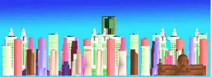
Figure 1: A 600K-triangle urban model used in the algorithms.
mold and it is used in the cellulization process required for the oc-clusion culling algorithms. Besides, terrain height field information can be extracted from the resultant structure, hence providing a way to implement urban navigation systems with terrains.
Current occlusion culling algorithms, which use preprocessing for occlusion determination, need large amount of data to store the visibility lists for each viewpoint. One of the most promising re-sult of our navigation space extraction method is that it becomes suitable to develop other general structures which yields natural oc-clusion determination for urban scenes and decrease the amount of the data that is needed to be stored drastically. In the next section, we give related work on the subject. In following sections, we de-scribe our approach and the algorithm we developed as a solution to this problem.
2. RELATED WORK
The method proposed in this paper automatically constructs the nav-igation space for complex urban scenes like the one in Figure 1. If 3D navigation is not required, the resultant navigation space struc-ture can also be used for the navigations that are bounded to the ground.
Generally, navigation space extraction for building interiors is not necessary, because rooms of the architectural model naturally correspond to cells, where it is not important to cellulize the rooms again as in [1, 8, 9]. In [1], the cell-to-cell visibility is defined, where a portal sequence is constructed from a cell to the others if a sightline exists, thereby making a whole cell navigable. In [4], the user is assumed to be navigating on the ground. Besides, the city they use was built using footprints, where the ground information becomes explicit.
Sometimes it is quite sufficient to determine the navigable area during model design time. In [2], the developed walkthrough sys-tem accepts streets or paths as navigable, where a triangle is defined as either a street or a path triangle. This means that in order to nav-igate over a triangle, it must be a part of a street or a path. Besides, only triangles are accepted for view-cells. Both of these properties make extending user navigation into the 3D space very challeng-ing, although the algorithm for occlusion culling that the authors develop is suitable for this extension.
In [3], the user is assumed to be at two meters above streets. Besides, the created model has straight streets, making navigation space determination straightforward. Likewise, in [5, 6, 4] the
au-thors also implement navigation assuming the user is on the ground, where the navigable space information is explicit and in 2D.
We need to mention that our aim is not to provide an envi-ronment where collision tests are optimized, although the resultant structure provides this. Specifically, we aim to create a suitable data structure where cellulization for occlusion culling preprocess becomes a simple task for complex urban scenes.
As a summary, except [10], where 3D navigation is performed using parallel computing, almost all other algorithms perform 2D navigation where extraction of navigation space is straightforward and model complexity is limited into some extend. Hence, a simple and yet powerful navigation space determination in 3D becomes vital for 3D navigation applications.
3. NAVIGATION SPACE EXTRACTION ALGORITHM 3.1 Extraction Process
We need to mention that the input data formats do not have sig-nificant importance on the efficiency of the algorithm, because our approach is nearly independent of the input data format. The only assumption is that the scene must be composed of triangles. One of the most common data format is dxf data format created by
Au-todesk, Inc. The data structure used to store this file is a forest type
data structure equipped with suitable fields designating the parame-ters of the other algorithms.
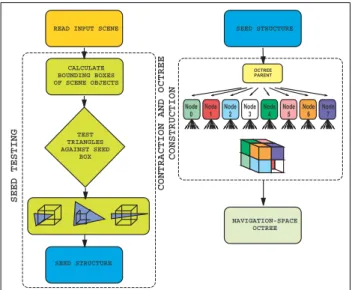
The navigation space extraction algorithm mainly consists of two phases: 1) the seed test, and 2) the contraction and the octree construction part. In the first phase, the bounding boxes of objects are calculated and a seed box is travelled around each object to find the blocks that touch the surface of it. Filled seeds are later passed to a contraction algorithm in which the octree structure for the nav-igable area is constructed and the mold of the object is extracted. It should be noted that it is possible to find all holes and passages inside the objects within a user specified threshold using this ap-proach. The flow diagram of our algorithm is shown in Figure 2.
After reading the scene database from the input file, the algo-rithm first calculates the bounding boxes of each object in the scene. Object discrimination is done while constructing the scene file and each object (i.e., building) is defined with a header and triangles are inserted into the list according to the object names, which is a prop-erty of the dxf file format. The bounding boxes are calculated in a straightforward manner and stored in the relevant structures. Seed testing and contraction parts of the algorithm take place in these bounding boxes and all space out of these boxes are accepted to be navigable.
3.2 Seed Testing
The seed testing phase is based on a box with a size of a user-defined threshold. We call this size as threshold because it defines the roughness of the extracted mold of the object. The time needed to extract the navigable area strictly depends on the size of the seed box.
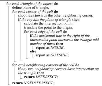
We start by reading the scene data. The next thing is to cal-culate the bounding boxes of each object in the scene. The object discretization algorithm is based on grid cells with a user-defined size threshold. This threshold defines the roughness of the extracted mold of the object. The algorithm travels inside the bounding box of the object to find the occupied grid cells. A grid cell and a triangle may intersect in three ways, which are shown in Figure 3.
The first case is where any vertex (or vertices) of the triangle is inside the cell. This case is the easiest to determine, in which a range test gives the intended result (Figure 3 (a)). The second case, none of the vertices of the triangle is inside the cell but the triangle plane intersects the edges of the cell, is handled by performing ray plane intersection test (Figure 3 (b)). In the algorithm to detect this case, the main idea is to shoot rays from each corner of the cell to each coordinate axis direction. The last case (Figure 3 (c)), where the triangle penetrates the cell without touching any of its edges is handled in a similar way, but this time the rays are shot from the vertices of the triangle and checks are made against the surfaces of
READ INPUT SCENE
CALCULATE BOUNDING BOXES OF SCENE OBJECTS TEST TRIANGLES AGAINST SEED BOX SEED STRUCTURE SEED STRUCTURE NAVIGATION-SPACE OCTREE OCTREE PARENT Node 3 Node 2 Node 1 Node
0 Node4 Node5 Node6 Node7
SEED TESTING
CONTRACTION AND OCTREE
CONSTRUCTION
Figure 2: Flow diagram of the Navigation Space Extraction algo-rithm. 00000 00000 00000 00000 00000 00000 00000 00000 00000 00000 00000 00000 00000 00000 00000 00000 00000 00000 00000 00000 00000 00000 00000 00000 00000 00000 00000 00000 00000 00000 00000 00000 00000 00000 00000 00000 00000 00000 00000 00000 00000 00000 00000 00000 11111 11111 11111 11111 11111 11111 11111 11111 11111 11111 11111 11111 11111 11111 11111 11111 11111 11111 11111 11111 11111 11111 11111 11111 11111 11111 11111 11111 11111 11111 11111 11111 11111 11111 11111 11111 11111 11111 11111 11111 11111 11111 11111 11111 0000000000000000000000000 0000000000000000000000000 0000000000000000000000000 0000000000000000000000000 0000000000000000000000000 0000000000000000000000000 0000000000000000000000000 0000000000000000000000000 0000000000000000000000000 0000000000000000000000000 0000000000000000000000000 0000000000000000000000000 1111111111111111111111111 1111111111111111111111111 1111111111111111111111111 1111111111111111111111111 1111111111111111111111111 1111111111111111111111111 1111111111111111111111111 1111111111111111111111111 1111111111111111111111111 1111111111111111111111111 1111111111111111111111111 1111111111111111111111111 0000 0000 0000 0000 0000 0000 0000 0000 0000 0000 0000 0000 0000 0000 0000 0000 0000 0000 0000 0000 0000 0000 0000 0000 0000 0000 0000 0000 0000 0000 0000 1111 1111 1111 1111 1111 1111 1111 1111 1111 1111 1111 1111 1111 1111 1111 1111 1111 1111 1111 1111 1111 1111 1111 1111 1111 1111 1111 1111 1111 1111 1111 0000000 0000000 0000000 0000000 0000000 0000000 0000000 0000000 0000000 0000000 0000000 0000000 0000000 0000000 0000000 0000000 0000000 0000000 0000000 0000000 0000000 0000000 0000000 0000000 1111111 1111111 1111111 1111111 1111111 1111111 1111111 1111111 1111111 1111111 1111111 1111111 1111111 1111111 1111111 1111111 1111111 1111111 1111111 1111111 1111111 1111111 1111111 1111111 00000000000000000 00000000000000000 00000000000000000 00000000000000000 00000000000000000 00000000000000000 11111111111111111 11111111111111111 11111111111111111 11111111111111111 11111111111111111 11111111111111111 000000000000000000 000000000000000000 000000000000000000 000000000000000000 000000000000000000 000000000000000000 000000000000000000 000000000000000000 000000000000000000 000000000000000000 000000000000000000 000000000000000000 000000000000000000 000000000000000000 000000000000000000 000000000000000000 000000000000000000 000000000000000000 000000000000000000 000000000000000000 000000000000000000 000000000000000000 000000000000000000 000000000000000000 000000000000000000 000000000000000000 000000000000000000 000000000000000000 000000000000000000 000000000000000000 000000000000000000 000000000000000000 000000000000000000 000000000000000000 000000000000000000 000000000000000000 000000000000000000 000000000000000000 000000000000000000 000000000000000000 000000000000000000 000000000000000000 000000000000000000 000000000000000000 111111111111111111 111111111111111111 111111111111111111 111111111111111111 111111111111111111 111111111111111111 111111111111111111 111111111111111111 111111111111111111 111111111111111111 111111111111111111 111111111111111111 111111111111111111 111111111111111111 111111111111111111 111111111111111111 111111111111111111 111111111111111111 111111111111111111 111111111111111111 111111111111111111 111111111111111111 111111111111111111 111111111111111111 111111111111111111 111111111111111111 111111111111111111 111111111111111111 111111111111111111 111111111111111111 111111111111111111 111111111111111111 111111111111111111 111111111111111111 111111111111111111 111111111111111111 111111111111111111 111111111111111111 111111111111111111 111111111111111111 111111111111111111 111111111111111111 111111111111111111 111111111111111111 0000000000000000000000000 0000000000000000000000000 0000000000000000000000000 0000000000000000000000000 0000000000000000000000000 0000000000000000000000000 0000000000000000000000000 0000000000000000000000000 0000000000000000000000000 0000000000000000000000000 0000000000000000000000000 0000000000000000000000000 0000000000000000000000000 1111111111111111111111111 1111111111111111111111111 1111111111111111111111111 1111111111111111111111111 1111111111111111111111111 1111111111111111111111111 1111111111111111111111111 1111111111111111111111111 1111111111111111111111111 1111111111111111111111111 1111111111111111111111111 1111111111111111111111111 1111111111111111111111111 000000000000000000000000 000000000000000000000000 000000000000000000000000 000000000000000000000000 000000000000000000000000 000000000000000000000000 000000000000000000000000 000000000000000000000000 000000000000000000000000 000000000000000000000000 000000000000000000000000 000000000000000000000000 000000000000000000000000 111111111111111111111111 111111111111111111111111 111111111111111111111111 111111111111111111111111 111111111111111111111111 111111111111111111111111 111111111111111111111111 111111111111111111111111 111111111111111111111111 111111111111111111111111 111111111111111111111111 111111111111111111111111 111111111111111111111111 0000 0000 0000 0000 0000 0000 0000 0000 0000 0000 0000 0000 0000 0000 0000 0000 0000 0000 0000 0000 0000 0000 0000 0000 0000 0000 0000 0000 0000 0000 0000 1111 1111 1111 1111 1111 1111 1111 1111 1111 1111 1111 1111 1111 1111 1111 1111 1111 1111 1111 1111 1111 1111 1111 1111 1111 1111 1111 1111 1111 1111 1111 0000 0000 0000 0000 0000 0000 0000 0000 0000 0000 0000 0000 0000 0000 0000 0000 0000 0000 0000 0000 0000 0000 0000 0000 0000 0000 0000 0000 0000 0000 0000 1111 1111 1111 1111 1111 1111 1111 1111 1111 1111 1111 1111 1111 1111 1111 1111 1111 1111 1111 1111 1111 1111 1111 1111 1111 1111 1111 1111 1111 1111 1111 00000000000000000 00000000000000000 00000000000000000 00000000000000000 00000000000000000 00000000000000000 11111111111111111 11111111111111111 11111111111111111 11111111111111111 11111111111111111 11111111111111111 0000000000000000 0000000000000000 0000000000000000 0000000000000000 0000000000000000 1111111111111111 1111111111111111 1111111111111111 1111111111111111 1111111111111111 000 000 000 000 000 000 000 000 000 000 000 000 000 000 000 000 000 000 000 000 000 000 000 000 000 000 000 000 000 000 000 000 000 000 000 111 111 111 111 111 111 111 111 111 111 111 111 111 111 111 111 111 111 111 111 111 111 111 111 111 111 111 111 111 111 111 111 111 111 111 (b) (a) (c) 0000 0000 0000 0000 0000 0000 0000 0000 0000 0000 0000 0000 0000 0000 0000 0000 1111 1111 1111 1111 1111 1111 1111 1111 1111 1111 1111 1111 1111 1111 1111 1111
Figure 3: Test cases: (a) any vertex is inside the cell; (b) the
ver-tices of the triangle is not inside the cell, but the cell edges intersect with the triangle surface (See Algorithm 1); (c) the triangle edges intersect with the surfaces of the cell. The idea behind this testing is to determine each unit cube, which has an interaction with at least one triangle. We believe, this will help us to create more realis-tic data structures, which are specifically designed for urban scene occlusion culling.
the cell. This process is repeated until all locations in the bounding box of the object is tested. A sample discretization for an object in 2D is shown in Figure 4 (a). With this approach, it is possible to use all holes and passages through the objects as part of the navigable area (see Figure 4 (b)).
The discretization of the object structure by testing each unit cube with the triangle structure (See Figure 3) is essential with two respects: one is the definition of the object hierarchy, and the other is creating an object structure which may be an alternative to current octree-like structure, which is a future work that is mentioned in the conclusion part.
3.3 Extraction of Navigable Space
Although the uniform subdivision provides the occupied cell in-formation, which is enough to determine the navigable space, its memory requirement is high. In order to overcome this problem, an adaptive subdivision is applied to the bounding box of the object to extract the navigable area as an octree structure. This is done using the occupied cell information provided by the uniform subdivision. An example of the created structure is shown in Figures 5 and 6.
The navigation octrees for each object are tied up to the spatial forest of octrees that corresponds to the whole scene. The empty area outside the objects in the scene is also a part of the navigable space.
xxxxx xxxxx xxxxx xxxxx xxxxx xxxxxxxxxxxxxxxxx xxxxxxxxxxxxxxxxx xxxxxxxxxxxxxxxxx xxxxxxxxxxxxxxxxx xxxxxxxxxxxxxxxxx xxxxxxxxxxxxxxxxx xxxxxxxxxxxxxxxxx xxxxxxxxxxxxxxxxx xxxxxxxxxxxxxxxxx xxxxxxxxxxxxxxxxx xxxxxxxxxxxxxxxxx xxxxxxxxxxxxxxxxx xxxxxxxxxxxxxxxxx xxxxxxxxxxxxxxxxx xxxxxxxxxxxxxxxxx xxxxxxxxxxxxxxxxx xxxxxxxxxxxxxxxxx xxxxxxxxxxxxxxxxx xxxxxxxxx xxxxxxxxx xxxxxxxxx xxxxxxxxx xxxxxxxxx xxxxxxxxx xxxxxxxxx xxxxxxxxx xxxxxxxxx xxxxxxxxx xxxxxxxxxxxxxxxxx xxxxxxxxxxxxxxxxx xxxxxxxxxxxxxxxxx xxxxxxxxxxxxxxxxx xxxxxxxxxxxxxxxxx xxxxxxxxxxxxxxxxx xxxxxxxxxxxxxxxxx xxxxxxxxxxxxxxxxx xxxxxxxxxxxxxxxxx xxxxxxxxxxxxxxxxx xxxxxxxxxxxxxxxxx xxxxxxxxxxxxxxxxx xxxxxxxxxxxxxxxxx xxxxxxxxxxxxxxxxx xxxxxxxxxxxxxxxxx xxxxxxxxxxxxxxxxx xxxxxxxxxxxxxxxxx xxxxx xxxxx xxxxx xxxxx xxxxx xxxxx xxxxx xxxxx xxxxx xxxxx xxxxx xxxxx xxxxx xxxxx xxxxx xxxxx xxxxx xxxxx xxxxx xxxxx xxxxx xxxxx xxxxx xxxxx xxxxx xxxxx xxxxx xxxxx xxxxx xxxxx xxxxx xxxxx xxxxx xxxxx xxxxx xxxxx xxxxx xxxxx xxxxx xxxxx xxxxx xxxxx xxxxx xxxxx xxxxx xxxxx xxxxx xxxxx xxxxx xxxxx xxxxx xxxxx xxxxx xxxxx xxxxx xxxxx xxxxx xxxxx xxxxx xxxxx xxxxx xxxxx xxxxx xxxxx xxxxx xxxxx xxxxx xxxxx xxxxx xxxxx xxxxx xxxxx xxxxx xxxxx xxxxx xxxxx xxxxx xxxxx xxxxx xxxxx xxxxx xxxxx xxxxx xxxxx xxxxx xxxxx xxxxx xxxxx xxxxx xxxxx xxxxx xxxxx xxxxx xxxxx xxxxx xxxxx xxxxx xxxxx xxxxx xxxxx xxxxx xxxxx xxxxx xxxxxx xxxxxx xxxxxx xxxxxx xxxxxx xxxxxx xxxxx xxxxx xxxxx xxxxx xxxxx xxxxx xxxxx xxxxx xxxxx xxxxx xxxxx xxxxx xxxxx xxxxx xxxxx xxxxx xxxxx xxxxx xxxxx xxxxx xxxxx xxxxx xxxxx xxxxx xxxxx xxxxx xxxxx xxxxx xxxxx xxxxx xxxxx xxxxx xxxxx xxxxx xxxxx xxxxx xxxxx xxxxx xxxxx xxxxx xxxxx xxxxx xxxxx xxxxx xxxxx xxxxx xxxxx xxxxx xxxxxx xxxxxx xxxxxx xxxxxx xxxxxx xxxxx xxxxx xxxxx xxxxx xxxxx xxxxx xxxxx xxxxx xxxxx xxxxx xxxxx xxxxx xxxxx xxxxx xxxxx xxxxx xxxxx xxxxx xxxxx xxxxx xxxxx xxxxx xxxxx xxxxx xxxxx xxxxx xxxxx xxxxx xxxxx xxxxx xxxxx xxxxx xxxxx xxxxx xxxxx xxxxx xxxxx xxxxx xxxxx xxxxx xxxxx xxxxx xxxxx xxxxx xxxxx xxxxxx xxxxxx xxxxxx xxxxxx xxxxxx xxxxxx xxxxxx xxxxxx xxxxxx xxxxxx xxxxxx xxxxxx xxxxxx xxxxxx xxxxxx xxxxxx xxxxx xxxxx xxxxx xxxxx xxxxx xxxxxxxxx xxxxxxxxx xxxxxxxxx xxxxxxxxx xxxxxxxxx xxxxxxxxx xxxxxxxxx xxxxxxxxx xxxxxxxxx xxxxxxxxx xxxxxxxxxx xxxxxxxxxx xxxxxxxxxx xxxxxxxxxx xxxxxxxxxx xxxxxxxxxx xxxxxxxxxx xxxxxxxxxx xxxxxxxxxx xxxxxxxxxx xxxxxxxxxx xxxxxxxxxx xxxxxxxxxx xxxxxxxxxx xxxxxxxxxx xxxxxxxxxx xxxxxxxxxx xxxxxxxxxx xxxxxxxxxx xxxxxxxxx xxxxxxxxx xxxxxxxxx xxxxxxxxx xxxxxxxxx xxxxxxxxx xxxxxxxxx xxxxxxxxx xxxxxxxxx xxxxxxxxxx xxxxxxxxxx xxxxxxxxxx xxxxxxxxxx xxxxxxxxxx xxxxxxxxxx xxxxxxxxxx xxxxxxxxxx xxxxxxxxxx xxxxxxxxxx xxxxxxxxxx xxxxxxxxxx xxxxxxxxxx xxxxxxxxxx xxxxxxxxxx xxxxxxxxxx xxxxxxxxxx xxxxxxxxxx xxxxxxxxxx xxxxxxxxxx xxxxxxxxxx xxxxxxxxxx xxxxxxxxxx xxxxxxxxxx xxxxxxxxxx xxxxxxxxxx xxxxxxxxxx (a) xxxxxxxxxxxxxxxxx xxxxxxxxxxxxxxxxx xxxxxxxxxxxxxxxxx xxxxxxxxxxxxxxxxx xxxxxxxxxxxxxxxxx xxxxxxxxxxxxxxxxx xxxxxxxxxxxxxxxxx xxxxxxxxxxxxxxxxx xxxxxxxxxxxxxxxxx xxxxxxxxxxxxxxxxx xxxxxxxxxxxxxxxxx xxxxxxxxxxxxxxxxx xxxxxxxxxxxxxxxxx xxxxxxxxxxxxxxxxx xxxxxxxxxxxxxxxxx xxxxxxxxxxxxxxxxx xxxxxxxxxxxxxxxxx xxxxxxxxxxxxxxxxx xxxxxxxxx xxxxxxxxx xxxxxxxxx xxxxxxxxx xxxxxxxxx xxxxxxxxx xxxxxxxxx xxxxxxxxx xxxxxxxxx xxxxxxxxx xxxxxxxxxxxxxxxxx xxxxxxxxxxxxxxxxx xxxxxxxxxxxxxxxxx xxxxxxxxxxxxxxxxx xxxxxxxxxxxxxxxxx xxxxxxxxxxxxxxxxx xxxxxxxxxxxxxxxxx xxxxxxxxxxxxxxxxx xxxxxxxxxxxxxxxxx xxxxxxxxxxxxxxxxx xxxxxxxxxxxxxxxxx xxxxxxxxxxxxxxxxx xxxxxxxxxxxxxxxxx xxxxxxxxxxxxxxxxx xxxxxxxxxxxxxxxxx xxxxxxxxxxxxxxxxx xxxxxxxxxxxxxxxxx xxxxxxxxxxxxxxxxx xxxxxxxxxxxxxxxxx xxxxx xxxxx xxxxx xxxxx xxxxx xxxxx xxxxx xxxxx xxxxx xxxxx xxxxx xxxxx xxxxx xxxxx xxxxx xxxxx xxxxx xxxxx xxxxx xxxxx xxxxx xxxxx xxxxx xxxxx xxxxx xxxxx xxxxx xxxxx xxxxx xxxxx xxxxx xxxxxx xxxxxx xxxxxx xxxxxx xxxxxx xxxxxx xxxxx xxxxx xxxxx xxxxx xxxxx xxxxx xxxxxx xxxxxx xxxxxx xxxxxx xxxxxx xxxxxx xxxxxx xxxxxx xxxxxx xxxxxx xxxxxx xxxxxx xxxxxx xxxxxx xxxxxx xxxxxx xxxxx xxxxx xxxxx xxxxx xxxxx xxxxx xxxxx xxxxx xxxxx xxxxx xxxxx xxxxx xxxxx xxxxx xxxxx xxxxx xxxxx xxxxx xxxxx xxxxx xxxxx xxxxx xxxxx xxxxx xxxxx xxxxx xxxxx xxxxx xxxxx xxxxx xxxxx xxxxx xxxxx xxxxx xxxxx xxxxx xxxxx xxxxx xxxxx xxxxx xxxxx xxxxx xxxxx xxxxx xxxxx xxxxx xxxxx xxxxxx xxxxxx xxxxxx xxxxxx xxxxxx xxxxx xxxxx xxxxx xxxxx xxxxx xxxxx xxxxx xxxxx xxxxx xxxxx xxxxx xxxxx xxxxx xxxxx xxxxx xxxxx xxxxx xxxxx xxxxx xxxxx xxxxxx xxxxxx xxxxxx xxxxxx xxxxxx xxxxx xxxxx xxxxx xxxxx xxxxx xxxxx xxxxx xxxxx xxxxx xxxxx xxxxx xxxxx xxxxx xxxxx xxxxx xxxxx xxxxx xxxxx xxxxx xxxxx xxxxx xxxxx xxxxxx xxxxxx xxxxxx xxxxxx xxxxxx xxxxxx xxxxxx xxxxxx xxxxxx xxxxxx xxxxx xxxxx xxxxx xxxxx xxxxx xxxxx xxxxxx xxxxxx xxxxxx xxxxxx xxxxxx xxxxx xxxxx xxxxx xxxxx xxxxx xxxxx xxxxx xxxxx xxxxx xxxxx xxxxx xxxxx xxxxx xxxxx xxxxx xxxxx xxxxx xxxxx xxxxx xxxxx xxxxx xxxxx xxxxx xxxxx xxxxx xxxxx xxxxxx xxxxxx xxxxxx xxxxxx xxxxxx xxxxxx xxxxxx xxxxxx xxxxxx xxxxxx xxxxxx xxxxxx xxxxxx xxxxxx xxxxxx xxxxx xxxxx xxxxx xxxxx xxxxx xxxxx xxxxxxxxx xxxxxxxxx xxxxxxxxx xxxxxxxxx xxxxxxxxx xxxxxxxxx xxxxxxxxx xxxxxxxxx xxxxxxxxx xxxxxxxxx xxxxxxxxxx xxxxxxxxxx xxxxxxxxxx xxxxxxxxxx xxxxxxxxxx xxxxxxxxxx xxxxxxxxxx xxxxxxxxxx xxxxxxxxxx xxxxxxxxxx xxxxxxxxxx xxxxxxxxxx xxxxxxxxxx xxxxxxxxxx xxxxxxxxxx xxxxxxxxxx xxxxxxxxxx xxxxxxxxxx xxxxxxxxxx xxxxxxxxx xxxxxxxxx xxxxxxxxx xxxxxxxxx xxxxxxxxx xxxxxxxxx xxxxxxxxx xxxxxxxxx xxxxxxxxx xxxxxxxxx xxxxxxxxxx xxxxxxxxxx xxxxxxxxxx xxxxxxxxxx xxxxxxxxxx xxxxxxxxxx xxxxxxxxxx xxxxxxxxxx xxxxxxxxxx xxxxxxxxxx xxxxxxxxxx xxxxxxxxxx xxxxxxxxxx xxxxxxxxxx xxxxxxxxxx xxxxxxxxxx xxxxxxxxxx xxxxxxxxxx xxxxxxxxxx xxxxxxxxxx xxxxxxxxxx xxxxxxxxxx xxxxxxxxxx xxxxxxxxxx xxxxxxxxxx xxxxxxxxxx xxxxxxxxxx xxxxxxxxxx xxxxxxxxxx xxxxxxxxxx xxxxx xxxxx xxxxx xxxxx xxxxx xxxxx xxxxx xxxxx xxxxx xxxxx xxxxx xxxxx xxxxx xxxxx xxxxx xxxxx xxxxx xxxxx xxxxx xxxxx xxxxx xxxxx xxxxx xxxxx xxxxx xxxxx xxxxxx xxxxxx xxxxxx xxxxxx xxxxxx xxxxxx xxxxx xxxxx xxxxx xxxxx xxxxx xxxxxx xxxxxx xxxxxx xxxxxx xxxxxx xxxxxx xxxxx xxxxx xxxxx xxxxx xxxxx xxxxx xxxxx xxxxx xxxxx xxxxx xxxxx xxxxx xxxxx xxxxx xxxxx xxxxx xxxxx xxxxx xxxxx xxxxx xxxxx xxxxx xxxxx xxxxx xxxxx xxxxx xxxxx xxxxx xxxxx xxxxx xxxxx xxxxxx xxxxxx xxxxxx xxxxxx xxxxxx xxxxxx xxxxx xxxxx xxxxx xxxxx xxxxx xxxxx xxxxx xxxxx xxxxx xxxxx xxxxx xxxxx xxxxx xxxxx xxxxx xxxxx xxxxx xxxxx xxxxx xxxxx xxxxx xxxxx xxxxx xxxxx xxxxx xxxxx xxxxxx xxxxxx xxxxxx xxxxxx xxxxxx xxxxx xxxxx xxxxx xxxxx xxxxx (b)
Figure 4: (a) Discretization of an object in 2D for easy interpreta-tion. It is normally performed in 3D. The object is represented with uniform grid cells (filled boxes show the complement of the object space, which corresponds to the navigable area represented as an octree using adaptive subdivision to reduce memory requirements.) (b) Any holes and passages can safely be represented as part of the navigable area.
We did not make any assumptions on the type of scene objects, or on their respective locations, while determining the navigable space information. The objects may have any type of architectural property, such as pillars, holes, balconies etc. Our algorithm in-discriminately finds the locations not occupied by any object part. This property makes our approach very suitable for the models that are created from different sources such as LIDAR, because the only information needed is triangle information, which most model for-mats have, or otherwise the primitives that are convertible to them.
(a) (b) (c)
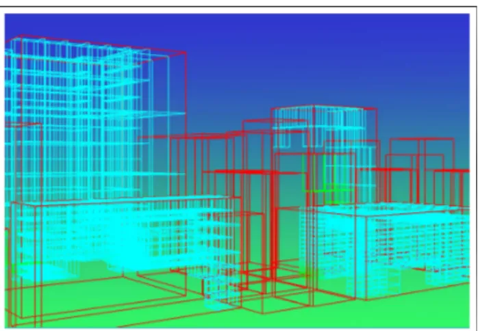
Figure 5: Navigation octree construction: (a) the original object; (b) cells of the object, where the triangles of it pass through; (c) the created navigation octree, in which navigable space information is embedded. In the figure, the black lines show the occupied cells and the green lines show the boundaries of the navigation octree for the object.
3.4 Contraction and Octree Construction
After the seed test phase is finished, we have a discretized version of the scene objects, where we exactly know the spatial locations occupied by the triangles of the object within a certain threshold. Although the occupied seed cell information is enough for us to de-termine the navigable space, its memory requirement is very high. Therefore, we need to contract this area and determine the naviga-ble space using another structure requiring less memory space. An octree structure is used for this purpose.
The octree structure constructed is shown in Figure 2. The algo-rithm for the octree construction simultaneously contracts the space
for each triangle of the object do
define plane of triangle;
for each corner of the cell do
shoot rays towards the other neighboring corner;
if the ray hits the plane of triangle then
calculate the intersection point; translate the point to the origin;
for each edge of the cell do
if the horizontal line to the right of the intersection point intersects the triangle odd number of times then
report as INSIDE;
else
report as OUT SIDE;
for each neighboring corners of the cell do
if any two neighboring corners have intersection on the triangle then
return INT ERSECT; return NOT INT ERSECT ;
Algorithm 1: The pseudo code for the detection of the
sec-ond case, where a triangle passes through a cell but none of the vertices of the triangle is inside the cell and the triangle plane intersects with the cell edges.
occupied by the seed cells into larger blocks of space as much as possible, thereby eliminating the need to keep filled cell informa-tion for every small seed. This is done as follows.
The constructed octree allows the navigable space to be tra-versed hierarchically. The algorithm first sets the bounding box of the object as the parent of the octree and checks if there is any filled cell within the range of the node. If there is any filled cell, then it recursively subdivides itself into eight octants and repeats the same procedure for the newly created nodes until the size of the node de-creases below the size of the seed box or there is nothing left but empty cells. This structure is tied to the spatial forest of octrees after all the scene objects are processed. It should be noted that the numbering scheme as seen in the Figure 2, provides neighboring information of the octree nodes.
3.5 Resultant Structure
The algorithm is concluded after all the scene objects are processed. The resultant octree structure represents the navigable area, where bounding boxes are tied up to spatial forest of octrees. An example of the created structure is shown in Figure 5. After this, the user ex-actly knows the locations in 3D where navigation is possible. The user will also know where the objects are and a hierarchical subdi-vision of them will also be provided as will be explained in the next section.
It should be noted that we did not make any assumptions on the type of scene objects or on their respective locations, while deter-mining the navigable space information. The objects may contain any type of architectural features, such as pillars, holes, balconies, etc. Our algorithm indiscriminately finds the locations where there is not any object part (i.e., triangle). This property makes our ap-proach very suitable for the models that are created from different sources, because the only information needed is triangles, where most model formats certainly provide. Other graphics primitives such as lines or polygons having more than three vertices are not handled, but they can easily be converted to triangles.
4. CREATING OBJECT STRUCTURE
In addition to creating the navigable space information of the scene database, it is very easy to create the octree for the scene itself, where further calculations on them can be performed. One impor-tant process that can be applied to the hierarchy is occlusion
deter-Figure 6: The octree forest of a scene created by the navigation space extraction algorithm having 24 buildings.
mination, where hierarchical calculations are strongly needed. After the contraction process is performed and the octree for navigation space constructed, the octree construction algorithm is repeated once more seeking full seed cells to discretize the object. This time the contraction part of the algorithm finds the cells which contain geometry in it, whereas we did it for empty cells while con-structing the octree for the navigation-space. The same procedure is applied to each object and scene objects are tied to the spatial for-est of object octrees. We are left with the two forfor-ests of octrees, one with the navigable space information and one with the object hierar-chy, which are useful for 3D navigation and scene object processing, respectively.
5. CONCLUSION
During the development of navigation systems for urban sceneries, the navigation determination becomes one of the most vital parts of the work. The navigation space determination is simple for the scene databases where the building footprints are used and the nav-igation is bounded to the ground. However, for the systems that need 3D navigation and the scene database is composed of com-plex objects where footprints do not define the navigable area, the navigation space determination becomes one of the most daunting tasks.
At this point, our approach becomes a solution to the definition of navigable space determination. It also constructs the hierarchical scene database as an additional feature. One important feature of our approach is that it is independent from the architecture of the scene objects. The building models may have pillars or holes where seeing through them is also possible. The method can be applied to any type of unstructured scene files composed of objects such as buildings. The application of the method produces two octrees; one containing the definition of the navigation area and another one containing the scene hierarchy, both in the form of the forest of octrees.
Currently we are working on developing alternative data struc-tures, which will help decrease the amount of the data necessary to store the visibility. Our aim is to develop a data structure that stores pointers for each building to store the visibility information, which reduces the amount of data to be stored drastically. The discretized version of the scene, being independent of the triangle structure will help us in the development of this data structure. We are also work-ing on developwork-ing an urban visualization framework that will use the data structures and the ideas proposed in this paper.
Instead of describing the occlusion in terms of buildings, we aim to subdivide the buildings into principal axis aligned slices and store the visilibity information in terms of these slices, instead of
individual buildings. The motivation for this is that current occlu-sion culling approaches accept a building as visible even if a very small portion of the building is visible, causing unnecessary over-loading of the graphics pipeline, especially if the buildings are very complex, containing ten to hundred thousands of polygons.
REFERENCES
[1] Thomas A. Funkhouser, Carlo H. Sequin, and Seth J. Teller, “Management of large amounts of data in interactive building walkthroughs,” in ACM Computer Graphics (1992 Symposium
on Interactive 3D Graphics), 1992, vol. 25(2), pp. 11–20.
[2] Gernot Schaufler, Julie Dorsey, Xavier Decoret, and Franc¸ois X. Sillion, “Conservative volumetric visibility with occluder fusion,” in ACM Computer Graphics (SIGGRAPH
’00 Proceedings), 2000, pp. 229–238.
[3] Laura Downs, Tomas M¨oller, and Carlo H. S´equin, “Oc-clusion horizons for driving through urban scenes,” in ACM
Computer Graphics (SIGGRAPH ’01 Proceedings), 2001, pp.
121–124.
[4] Peter Wonka, Michael Wimmer, and Dieter Schmalstieg, “Vis-ibility preprocessing with occluder fusion for urban walk-throughs,” in Proceedings of Rendering Techniques, 2000, pp. 71–82.
[5] Michael Wimmer, Markus Giegl, and Dieter Schmalstieg, “Fast walkthroughs with image caches and ray casting,”
Com-puters & Graphics, vol. 23, no. 6, pp. 831–838, 1999.
[6] Fr´edo Durand, George Drettakis, Jo¨elle Thollot, and Claude Puech, “Conservative visibility preprocessing using extended projections,” in ACM Computer Graphics (SIGGRAPH ’00
Proceedings), 2000, pp. 239–248.
[7] Dieter Schmalstieg and Robert F. Tobler, “Exploiting coher-ence in 2.5-D visibility computation,” Computers & Graphics, vol. 21, no. 1, pp. 121–123, 1997.
[8] C. Saona-V´azquez, I. Navazo, and P. Brunet, “The visibil-ity octree: a data structure for 3D navigation,” Computers &
Graphics, vol. 23, no. 5, pp. 635–643, 1999.
[9] Carlos And´ujar, Carlos Saona-V´azquez, Isabel Navazo, and Pere Brunet, “Integrating occlusion culling and levels of detail through hardly-visible sets,” Computer Graphics Forum, vol. 19, no. 3, pp. 499–506, 2000.
[10] Douglass Davis, William Ribarsky, T. Y. Jiang, Nickolas Faust, and Sean Ho, “Real-time visualization of scalably large collections of heterogeneous objects,” in Proceedings of IEEE