ANALYSIS OF THE DIFFERENT LAND REALLOCATION RESULTS IN LAND CONSOLIDATION PROJECT: A CASE STUDY IN ÜÇHÜYÜKLER NEIGHBORHOOD, ÇUMRA-KONYA-TURKEY
1Tayfun Çay, 2Ela Ertunç
1,2Selcuk University, Engineering Faculty, Department of Geomatics Engineering, Konya, Turkey, 1[email protected] , 2[email protected]
(Geliş/Received: 16.11.2016 ; Kabul/Accepted in Revised Form: 07.03.2017)
ABSTRACT: The most important, complex and time-consuming process of land consolidation is known as the reallocation phase. Reallocation processes in land consolidation projects in Turkey is made according to farmer preferences (interview). Besides, the optimization studies based on the mathematical models for the reallocation process in many scientific researches in addition to reallocation model based on interview have been conducted. But, because there isn’t a precise mathematical model for the reallocation process, many different solutions have been suggested.
In this study, importance of reallocation in land consolidation and interview-based and block priority-based reallocation models has been described. Also, the results of the block priority-based reallocation model that makes land reallocation by being take into account respectively the largest parcels belong to the farmers have been obtained. The results which are obtained from the block priority-based reallocation model has been compared with the results which are obtained from the interview-based reallocation model. In the consolidation area of the Üçhüyükler neighborhood Çumra-Konya-Turkey, previously the number of cadastral parcels were 265, the number of interview-based reallocation method parcels were 243. The number of this parcels according to the block priority-based reallocation model that is applied in this study have decreased to 237. Average parcel size was 3.30 hectares before consolidation in this region. Average parcel size has increased to 3.60 hectares according to the interview-based reallocation model and to 3.36 hectares according to the block priority-based reallocation model.
Key Words: Land consolidation, Reallocation, The interview-based reallocation, The block priority-based
reallocation
Arazi Toplulaştırma Projelerinde Farklı Dağıtım Sonuçlarının Analizi: Üçhüyükler Mahallesi, Çumra- Konya- Türkiye Örneği
ÖZ: Arazi toplulaştırmanın en önemli, karmaşık, zaman alıcı süreci dağıtım aşaması olarak bilinmektedir. Dağıtım, belirgin ve sınırlanabilen bir işlev olmayıp aksine birbirine bağlı ve birbirini tamamlayan unsurları içermekte, dolayısıyla karar vericiyi her zaman birden çok alternatifle karşı karşıya bırakmaktadır. Türkiye’de arazi toplulaştırma projelerinde dağıtım işlemleri çiftçi tercihlerine (mülakat) göre yapılmaktadır. Ayrıca, mülakata dayalı dağıtım modelinin yanında birçok bilimsel araştırmalarda dağıtım işlemi için matematik modellere dayalı optimizasyon çalışmaları da yapılmıştır. Ancak, dağıtım işlemi için kesin bir matematiksel model bulunmadığı için çok farklı çözümler önerilmiştir.
Bu çalışmada; arazi toplulaştırmasında dağıtımın önemi, mülakat esaslı ve blok öncelik esaslı dağıtım modeli anlatılmış ve arazi dağıtımını işletmelere ait en büyük ve en büyük ikinci parselleri
dikkate alarak yapan blok öncelik esaslı dağıtım modelinin sonuçları elde edilmiştir. Blok öncelik esaslı dağıtım modellerinden elde edilen sonuçlar mülakat esaslı dağıtım modelinden elde edilen sonuçlarla karşılaştırılmıştır. Üçhüyükler mahallesi (Çumra-Konya-Türkiye) toplulaştırma sahasında 265 adet eski kadastro parseli varken mülakat esaslı dağıtım modelinde parsel sayısı 243’e düşmüştür. Blok öncelik esaslı dağıtım modeline göre parsel sayısı 237 olmuştur. Ortalama parsel büyüklüğü ise toplulaştırma öncesinde 3.30 hektar iken, mülakat esaslı dağıtım modeline göre 3.36 hektar ve blok öncelik esaslı dağıtım modeline göre de 3.60 hektara çıkmıştır.
Anahtar Kelimeler: Arazi toplulaştırma, Dağıtım, Mülakat esaslı dağıtım, Blok öncelik esaslı dağıtım
INTRODUCTION
The agricultural infrastructure is developed which is primary importance in order to ensure more revenue per unit area and in order to compete with the world of agriculture of our country by making a high production efficiency. The most important issues are to develop the agricultural infrastructure which is the size of the existing structural problems and legal arrangements needed to solve the problems. Also, the issues are the responsible institutions increase and the financial resources are provided (Kirmikil, 2010).
The most important agricultural infrastructure problems in our country are that the lands owned by agricultural enterprises are fragmented as small parcels and that shapes of these lands are irregular. Also, these lands are lack of transport and road network. This situation complicates that farmers make economically agricultural production. Thus, agricultural development is unobtainable. Land consolidation is the best way to solve this problem for rural land.
The land consolidation which is the implementation on pasture lands of land and plot readjustment is an important tools that provides increased efficiency in agricultural production. In order to increase agricultural production, the lands that are shaped in the form of unfavourable and that are divided into multiple parts in small parcels and that belong to persons and businesses is shaped and planned by appropriately combining according to the principles of management of modern agriculture (Temel, 2013). The land consolidation is a necessary study in order to modernize rural areas, make economically a livable place and facilitate the environmental management (Sonnenberg, 1996; Van den Brink, 1999; Van Lier, 2000; Crecente et al., 2002; Çay et al., 2009; Ertunç and Çay, 2016). This process can be realized that economic, environmental and social factors are considered versatile (Gonzalez et al., 2004; Çay et al., 2009; Ertunç and Çay, 2016).
According to data the General Directorate of Agricultural Reform (ARGD), the land consolidation had been completed in the area, which is about 3 million hectares, by the end of the year 2012 in Turkey. The land consolidation of 11 million hectares areas has been planned to be completed between the year 2013 and the year 2023. Thus, the land consolidation of the total 14 million hectares areas will been completed by the end of the year 2023 in Turkey. This case emphasizes the importance of land editing projects and increases to the need that more efficient, more efficient and more expeditious methods are developed in the block distribution to complete quickly the land editing projects.
In this study, it has been investigated the applicability of the block priority-based reallocation model which is made by considering the biggest first and second parcels belonging to the companies. The land consolidation project in the Konya-Çumra-Üçhüyükler has been selected as the project area. The results of block priority-based distribution model with results of the traditional method that is known as interview-based distribution model were compared with each other according to the number of parcels and shares, average parcel size, the number of jointly owned parcels in distribution models, width / length ratios of parcels and the distance from the company center of the neighborhood center.
MATERIAL AND METHOD
According to Agrarian Reform Law in accordance with regulation of land on the irrigation areas with number 3083, the block reallocation is made according to interview-based reallocation model in land consolidation projects. In this study, the block reallocation has been made according to interview-based reallocation model and block priority-interview-based reallocation model.
Description of Application Area
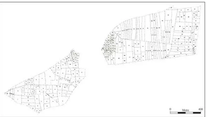
Üçhüyükler neighborhood of Çumra county of Konya province which is dominated continental climate have been selected as research area. Üçhüyükler neighborhood is away 13 km from Çumra county and is away 63 km from Konya provice. According to 2012 census data, the population of the neighbourhood is 801. The economy of the neighborhood depends on agriculture and animal husbandry. The area of land consolidation project that is made for Uçhüyükler neighborhood is 875.69 hectares. There are 275 farmers and 265 cadastral parcels in the consolidation area (Figure 1). 64 pieces of this cadastral parcels are jointly owned parcel. The average size of the cadastral parcels is 3.30 hectares.
Figure 1. The cadastral status of Üçhüyükler neighborhood RESULTS AND DISCUSSION
Interview-based reallocation model and block priority-based reallocation model have been examined in terms of the number of parcel, the average size of parcel, the number of shares of the reallocation methods, distance from Üçhüyükler Neighborhood center of the enterprise in the models, width / length ratios of parcels in the models and the number of parcels per enterprise of the models.
The Number of Parcels
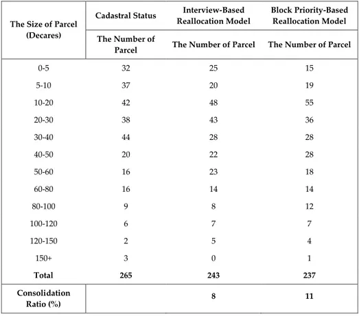
In the area where the research is carried out, the old and new cases of parcels belong to the farmers in terms of the number of parcel are shown in Table 1.
According to Table 1, in the area of land consolidation belonging to Üçhüyükler neighborhood, while the number of cadastral parcels were 265 prior to the study, this number decreased to 243 according to interview-based reallocation model. Whereas, the number of cadastral parcels decreased to 237 according to block priority-based reallocation model. While the consolidation ratio is 8% in interview-based reallocation model, this ratio has been realized as 11% in block priority-based reallocation model. In block priority-based reallocation model, the reason why rate of the consolidation is high is that the farmers' preferences aren’t taken into account.
Table 1. Examination of the models in terms of the number of parcels
The Size of Parcel (Decares)
Cadastral Status Interview-Based Reallocation Model
Block Priority-Based Reallocation Model The Number of
Parcel The Number of Parcel The Number of Parcel
0-5 32 25 15 5-10 37 20 19 10-20 42 48 55 20-30 38 43 36 30-40 44 28 28 40-50 20 22 28 50-60 16 23 18 60-80 16 14 14 80-100 9 8 12 100-120 6 7 7 120-150 2 5 4 150+ 3 0 1 Total 265 243 237 Consolidation Ratio (%) 8 11
The Average Size of Parcels
The average sizes of parcels belonging to the study area are seen in Table 2.
Table 2. The average sizes of parsels of the reallocation models
The Average Size of
Parcel Area (m 2) Increase Percentage (%) Cadastral status 33044.92 - Interview-based reallocation model 36063.64 9% Block priority-based reallocation model 36948.96 12%
Investigation in terms of the Number of Shares of the Reallocation Methods
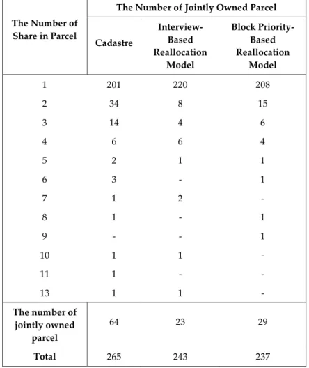
The situation in terms of the number of jointly owned parcels belonging to enterprises of reallocation models which is applied in application area belonging to Üçhüyükler neighborhood is shown in Table 3. According to Table 3, the number of jointly owned parcels were 64 before the reallocation. After the reallocations, while the number of jointly owned parcels are 29 for block priority-based reallocation model, this number are 23 for interview-priority-based reallocation model. Therefore, it can be said that interview-based reallocation model is more successful than block priority-based reallocation model in terms of the number of jointly owned parcels belonging to enterprises.
Table 3. The number of jointly owned parcels occurred with the reallocation methods
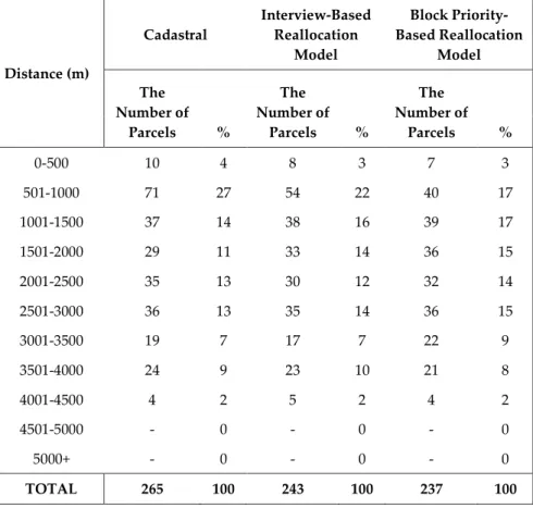
Examining in terms of Distance to Üçhüyükler Neighborhood Center of the Enterprise in the Models In the application area, distances which are the shortest travel distances between the center of the parcels belonging to the enterprises with the center of Üçhüyükler neighbourhood have been determined by measuring one by one by taking into account the existing road network. Later, the average of these values has been taken. It has been indicated by the Ayrancı (1997) that the distance between the central of Neighborhood with parcels of enterprise in terms of enterprise’s economics and land-use is 3 km in each case.
The distances to the Neighborhood’s center of the enterprises is located in application area belonging to Üçhüyükler Neighborhood is shown in Table 4. According to Table 4, while the ratio of enterprise parcels, the distance of these parcels to the Neighborhood center is up to 3 km, is 82% prior to
The Number of Share in Parcel
The Number of Jointly Owned Parcel
Cadastre Interview-Based Reallocation Model Block Priority-Based Reallocation Model 1 201 220 208 2 34 8 15 3 14 4 6 4 6 6 4 5 2 1 1 6 3 - 1 7 1 2 - 8 1 - 1 9 - - 1 10 1 1 - 11 1 - - 13 1 1 - The number of jointly owned parcel 64 23 29 Total 265 243 237
land consolidation, in parcellation plan which is formed according to the results interview-based reallocation model and block priority-based reallocation model is 81% this ratio. According to this, a lot of change in terms of the distance to the Neighborhood center of enterprise parcels hasn’t seen in both models according to pre-land consolidation.
Table 4. The distance to Neighborhood center of the enterprise parcels belonging to Üçhüyükler Neighborhood Distance (m) Cadastral Interview-Based Reallocation Model Block Priority-Based Reallocation Model The Number of Parcels % The Number of Parcels % The Number of Parcels % 0-500 10 4 8 3 7 3 501-1000 71 27 54 22 40 17 1001-1500 37 14 38 16 39 17 1501-2000 29 11 33 14 36 15 2001-2500 35 13 30 12 32 14 2501-3000 36 13 35 14 36 15 3001-3500 19 7 17 7 22 9 3501-4000 24 9 23 10 21 8 4001-4500 4 2 5 2 4 2 4501-5000 - 0 - 0 - 0 5000+ - 0 - 0 - 0 TOTAL 265 100 243 100 237 100
The Examination in terms of Width / Length Ratios of Parcels in the Models
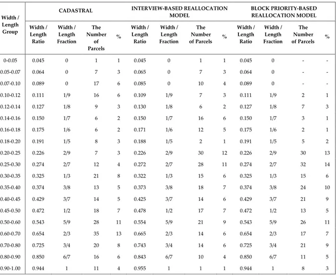
In consolidation projects, it is convenient that width / length ratios is choose from values between 1/4 - 1/5 by taking into consideration factors related to culture technical services (Çevik and Tekinel, 1989). This ratio can be between 1/2 - 1/7 in mandatory cases by depending on the size of land (Banger and Şişman, 2001; Çay, 2013).
Width / length ratios of the parcels located in the area of application are shown in Table 5. According to Table 5, width / length ratio, which are between 1/4 - 1/5, of parcels is 3% in cadastral parcels before land consolidation studies. Whereas, this ratio after land consolidation is 12% in interview-based reallocation model and is 13% in block priority-based reallocation model. While width / length ratio, which are between 1/2 - 1/7, of parcels is 39% in cadastral parcels before land consolidation, this ratio is 61% in both interview-based reallocation model and block priority-based reallocation model after land consolidation. Equally improvement increase in width / length ratios of parcels is observed in both models after land consolidation.
Table 5: Width / length ratios of the enterprise parcels belonging to Üçhüyükler region
Width / Length Group
CADASTRAL INTERVIEW-BASED REALLOCATION
MODEL BLOCK PRIORITY-BASED REALLOCATION MODEL Width / Length Ratio Width / Length Fraction The Number of Parcels % Width / Length Ratio Width / Length Fraction The Number of Parcels % Width / Length Ratio Width / Length Fraction The Number of Parcels % 0-0.05 0.045 0 1 1 0.045 0 1 1 0.045 0 - - 0.05-0.07 0.064 0 7 3 0.065 0 7 3 0.064 0 - - 0.07-0.10 0.089 0 17 6 0.085 0 10 4 0.089 0 - - 0.10-0.12 0.111 1/9 16 6 0.109 1/9 7 3 0.111 1/9 2 1 0.12-0.14 0.127 1/8 9 3 0.130 1/8 6 2 0.127 1/8 7 3 0.14-0.16 0.150 1/7 6 2 0.150 1/7 16 6 0.150 1/7 3 1 0.16-0.18 0.175 1/6 6 2 0.171 1/6 12 5 0.175 1/6 2 1 0.18-0.20 0.191 1/5 8 3 0.188 1/5 2 1 0.191 1/5 5 2 0.20-0.25 0.226 2/9 7 3 0.226 2/9 30 12 0.226 2/9 30 13 0.25-0.30 0.274 2/7 12 4 0.272 2/7 28 11 0.274 2/7 32 14 0.30-0.35 0.325 1/3 21 8 0.322 1/3 15 6 0.325 1/3 15 6 0.35-0.40 0.374 3/8 13 5 0.373 3/8 18 7 0.374 3/8 24 10 0.40-0.45 0.429 3/7 14 5 0.425 3/7 14 6 0.429 3/7 21 9 0.45-0.50 0.472 1/2 18 7 0.478 1/2 17 7 0.472 1/2 13 5 0.50-0.60 0.543 5/9 28 11 0.554 5/9 21 9 0.543 5/9 26 11 0.60-0.70 0.654 2/3 35 13 0.665 2/3 14 6 0.654 2/3 17 7 0.70-0.80 0.725 3/4 20 8 0.743 3/4 14 6 0.725 3/4 21 9 0.80-0.90 0.850 6/7 16 6 0.843 6/7 10 4 0.850 6/7 11 5 0.90-1.00 0.944 1 11 4 0.955 1 1 1 0.944 1 8 3
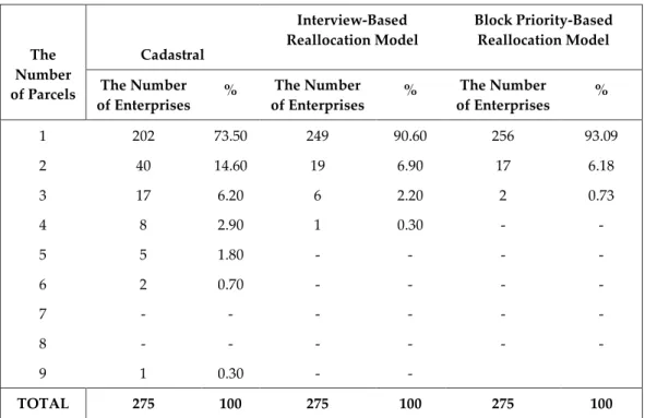
The Examination in terms of the Number of Parcels per Enterprise of the Models
The situation in terms of the number of parcels per enterprise of the reallocation models applied in the area of application are shown in Table 6. According to Table 6, the number of enterprises which are a single parcel are 202 before reallocation. This number corresponds to 73.5%. After consolidation, while this number increase to 249, which corresponds to 90.60%, for interview-based reallocation model, this number increase to 256, which corresponds to 93.09%, for block priority-based reallocation model. Therefore, it can be said that block priority-based reallocation model is more successful according to interview-based reallocation model in terms of the number of parcels per enterprise.
CONCLUSION
When obtained reallocation results are evaluated in terms of the number of parcels, the average size of parcel and the average number of parcels per enterprise, it has been seen that block priority-based reallocation model gives more successful results. Interview-based reallocation model has had more successful according to block priority-based reallocation model in terms of the number of jointly owned parcels per enterprises. A lot of change in terms of the distance to the Neighborhood center of enterprise parcels hasn’t seen in both models according to pre-land consolidation. Equally improvement increase in width / length ratios of parcels is observed in both models after land consolidation. If block
priority-based reallocation model can fulfill during the reallocation process that enterprises want to be in the same block with their relatives, more successful results can be obtained.
Table 6: The number of parcels per enterprise in the reallocation models
The Number of Parcels Cadastral Interview-Based Reallocation Model Block Priority-Based Reallocation Model The Number of Enterprises % The Number of Enterprises % The Number of Enterprises % 1 202 73.50 249 90.60 256 93.09 2 40 14.60 19 6.90 17 6.18 3 17 6.20 6 2.20 2 0.73 4 8 2.90 1 0.30 - - 5 5 1.80 - - - - 6 2 0.70 - - - - 7 - - - - 8 - - - - 9 1 0.30 - - TOTAL 275 100 275 100 275 100 ACKNOWLEDGEMENTS
This paper has been prepared by benefiting from the inventions of the project whose number is 114Y608 which supported by TÜBİTAK.
REFERENCES
Crecente, R., Alvarez, C., Fra, U., 2002, “Economic, Social and Environmental Impact of Land Consolidation in Galicia”, Land Use Policy, Vol. 19, pp. 135–147.
Çay, T., İşcan, F., Ayten, T., 2009, “Arazi Toplulaştırması Projelerinde Mülakat ve Blok Öncelik Esaslı Dağıtım Modellerinin Karşılaştırılması”, 4. Ulusal Mühendislik Ölçmeleri Sempozyumu, Trabzon-Turkey, pp. 418-427, 14-16 Ekim 2009.
Ertunç, E., Çay, T., 2016,”Analysis of Different Reallocation Results in Land Consolidation Project”, 6 th International Conference of Ecosystems (ICE 2016), Tirana-Albania, 03 - 06 June 2016.
Gonzalez, X.P., Alvarez, C.J., Crecente, R., 2004, “Evaluation of Land Reallocations With Joint Regard to Plot Size and Shape”, Agricultural Systems, Vol. 82, pp. 31–43.
Kirmikil, M., 2010, Sulama Proje Alanlarında Kırsal Aşan Geliştirilmesi İçin Arazi Toplulaştırması Rolünün GIS Destekli Analizi, PhD Thesis, Uludağ University, Graduate School of Natural Sciences, Bursa-Turkey.
Sonnenberg, J., 1996,”The European Dimensions and Land Management-Policy Issues (Land Readjustment and Land Consolidation As Tools For Development)”, Land Management in The Process of Transition. FIG Commission 7, Budapest-Hungary.
Temel, M., 2013, Kırsal alanların Korunarak Kalkınmasında ve Planlanmasında Bir Araç Olarak Arazi Toplulaştırması: Avrupa Birliği Türkiye Karşılaştırması, Master Thesis, Gazi University, Graduate School of Natural Sciences, Ankara-Turkey.
Van den Brink, A., 1999, “Sustainable Development and Land Consolidation”, In: Dixon-Gough, R.W. (Ed.), Land Reform and Sustainable Development, Ashgate, Aldershot, pp. 61–68.
Van Lier, H.N., 2000, “Land Use Planning and Land Consolidation in The Future in Europe”, Zeitschrift Fu R Kulturtechnik Und Landentwicklung, Vol. 41 (3), pp. 138–144.