IC
ON
A
RP
ICONARP
International Journal of Architecture & Planning Received 25 March 2017; Accepted 10 November 2017 Volume 5, Special Issue, pp: 77-90/Published 18 December 2017 DOI: 10.15320/ICONARP.2017.27-E-ISSN: 2147-9380 Research Article
Abstract
The city of Trabzon, was established on a plenary hillside which remains in between Tabakhane and Zağnos valleys horizontally. In resources, it is mentioned that the first usage of the city’s name was “Trapezus” which means “table” and this usage was a result of the city’s position, since it is established on a decent hillside which rises between two valleys. The east border of the study, which is the East Gate (Tabakhane Gate) of the historical walls, is important as it is the entrance point to the city through “Gavur Square”, which became the second centre of the city in time. The west border (Fatih Grand Mosque) of the study is also important since it is the oldest church of the city and it was the first example which was transformed into mosque due to Ottoman conquest procedures after the city was conquered by Fatih Sultan Mehmet. The border of the study is determined as the curled artery, which continues between these two historical elements and the public, and civil architectural examples in the artery from Tabakhane Mosque and Bridge to Fatih Grand Mosque are studied with a framework of historical chronology.
In the first phase of the study, brief information about the history of Ortahisar is composed and data about the historical structures in the determined area (Tabakhane Gate, Bridge and Mosque, Ortahisar and Old Government House, Fatih Grand Mosque) are compiled. In the second phase of the study, the space between the city’s east gate
The Entrance to Trabzon
from East Gate:
Tabakhane and Ortahisar
Neva Gerçek Atalay*
Bahar Karakaş**
Keywords: Historical City Center,
Conservation, Tabakhane, Ortahisar, Trabzon
*Res. Asst., Gazi University, Department of Architecture, Ankara, Turkey.
E-mail: [email protected]
Orcid ID: http://orcid.org/0000-0002-1426-3077
**Res. Asst., Karadeniz Technical University, Department of Architecture, Trabzon, Turkey.
E-mail: [email protected]
Orcid ID: http://orcid.org/0000-0002-3894-5160
I: 10 .15 32 0/ IC O N ARP. 20 17 .27 – E -I SSN : 21 47 -9380
(Tabakhane Gate) and the Fatih Grand Mosque (Panaghia Chrysokephalos Church), which is one of the most important sacred structures, transformed from church and still exists today, is evaluated by comparing the oldest photos that can be reached, archive documents from the Directorate of Cultural and Natural Heritage Conservation Board in Trabzon region, historical plans and the recent photos that are taken from close points. Evaluation of the subject is made through legal regulations, conscious of protection and Architectural approach. With this study, it is shown that how the area, which is determined as a 2nd degree urban protected area, exposed to interventions in the historical context. The evolution of the consciousness of protecting history in Ortahisar, the oldest centre of the city, from Republic to today, is analysed and argued.
In this study, it is evaluated how the historical urban fabric of Trabzon resist towards deformations and illegal structuring, in the historical continuity. Interventions to historical fabric, violation of the legal borders and unqualified spots mixed in the historical memory in an urban protected area are emphasized. Upon the light of the consequences that are reached, the study aims to contribute to the architectural protection conscious, and to set an example for studies of city history and protection in local/regional means.
As a result of observations and studies made in the field, it is seen that public structures are more important than civil architecture in terms of conservation approach in and around Ortahisar. Because of the several legal regulations and interventions made unconsciously, it is seen that the functional continuity interrupted in the historic city center. On the other side, it is observed that the protection practices carried out in the field remain at the regional level, can not be integrated with other parts of the city, and the visual, social and functional relations can not be established. It is also seen that, the reconstructed buildings are not in harmony with the historical background, and the use of green space is becoming inefficient. In the study, it is concluded that the Legal regulations, which are the 1965 Property Law and the 1985 Construction Law, are among the important factors affecting the mentioned transformation and change process.
INTRODUCTION
Trabzon is an important city geographically, strategically and historically located in the Eastern part of the Black Sea. For centuries, the city of Trabzon, under the dominance of the Komnenos Dynasty, the Byzantine Empire, the Ottoman State and the last Republic of Turkey, carries significant traces, especially from Byzantine, Ottoman and Republican periods. The multi-layered nature of the situation allows the buildings of different cultures to be seen today in the city of Trabzon. Trabzon city is in the upper ranks in the immovable cultural properties (civil architecture, remnants, preserved streets, religious-cultural-administrative-military-industrial and commercial buildings, cemeteries and monuments etc) statistics that needs to be protected according to the statistics made in Turkey according to
olu m e 5, Sp eci al Is su e / Pu bl is hed : D ecemb er 2017
the data of the year 2015 with the number of cultural properties it owns (URL-1). Many of the examples of the building that constitute an important reference for historical continuity are located in the Ortahisar Region, which is the historical city center of Trabzon.
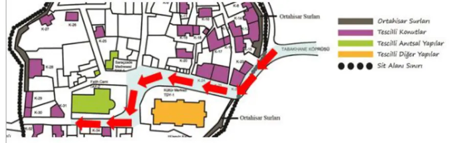
Trabzon city has been in an important structural change process for years. This process often affects the city negatively. The aim of the study is to go into how this process of change occurred between the Tabakhane bridge and the Ortahisar Fatih Mosque, which has been selected as the study area and a part of the city's 2nd urban protected area (see Figure 1). In the first phase of the study, essential information is compiled about the important historical structures of the area that are Tabakhane Door-Bridge and Mosque, Ortahisar, Old Government House and Fatih Grand Mosque. In the second phase of the study, the space between the city’s east gate (Tabakhane Gate) and the Fatih Grand Mosque, which is one of the most important sacred structures that transformed from church, is evaluated by comparing the oldest photos that can be reached, archive documents from the Directorate of Cultural and Natural Heritage Conservation Board in Trabzon region, historical plans and the recent photos that are taken from close points.
ABOUT THE DETERMINED HISTORICAL STRUCTURES Tabakhane (Tannary) Gate, Bridge And Mosque
The Eastern Gate of the historical walls forming the eastern border of the study area, in other words Tabakhane Gate; is one of the entrance gates of the old city from the city walls while moving from the current city square (Atatürk Square) to the Ortahisar site. Evliya Çelebi, while counting the gates of Ortahisar, spoke about the "Debbaglar Gate" and mentioned that the Tabakhane Bridge was built on the masonry bases (Tuluk ve Düzenli 2010). In the records of Katip Çelebi, the Yenicuma Gate is the first gate that opened to the east of Ortahisar and the second is the "Tabakhane" Gate which is located inside the boundaries of this study. The name of the Tabakhane Gate was taken from the
Figure 1. The Route of the Study Area
I: 10 .15 32 0/ IC O N ARP. 20 17 .27 – E -I SSN : 21 47 -9380
leather bazaar, which was located in front of this gate (Usta, 1999).
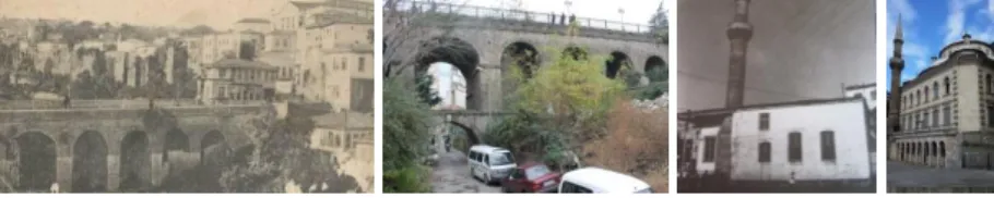
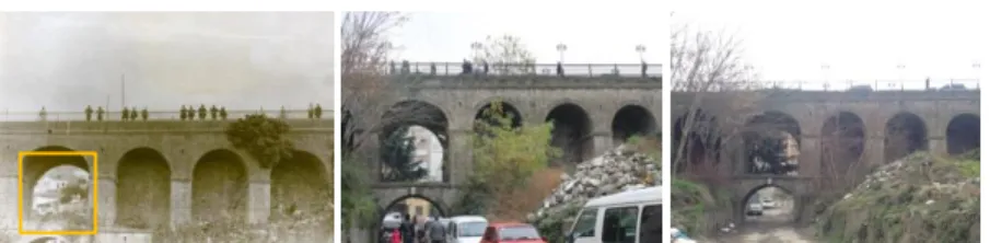
According to Bıjışkyan (1969), in the early 19th century (1817-1819) there was a wide and deep trench in front of the Tabakhane Gate, with a bridge over it. While, the water coming from the channel of Iustinianos passes over this bridge, the Kuzgundere flows below. The creek, still known as "Kuzgundere", is covered up and the axis passing through is utilized as a settlement area. Today, under the recycling project, the region has been completely emptied and the houses have been demolished. The Tabakhane Bridge, which was built on the Kuzgundere to the east of Ortahisar, was able to be exant by many repairs and expansion. The first foundation dates to the 1st century BC (Karpuz 1990). The Tabakhane Bridge is an Ottoman structure in its present state and regained its last shape in the 19th century (Karpuz 1990). The Tabakhane Bridge is made up of two separate thin bridges joined together by a longitudinal dilatation (Gerçek, 1990). It has a single arched opening at the first level. In the Ottoman period, a stone bridge with six oval arches was placed beside it (Karpuz 1990). The four culverts on this side were placed on the walls of the former bridge (Gerçek, 1990). It is thought that the additional bridge was constructed since the first bridge built during the Byzantine period became insufficient as a result of the changing life conditions.
The Tabakhane Mosque was originally planned as a small mosque, and it is thought that in the 1650s it had been repaired or rebuilt. In the 1973 reports of the Board, it is stated that the mosque is not appropriate to be reconstructed due to the fact that it is an "historical artifact to be protected" (Anonymous, 2017). However, in 1979, in the place of the second structure, which was demolished except its minaret, the third concrete structure, which was in use today, was built. In 1985, the registration of the structure was abolished (Anonymous 2017b) and in 1987 it was opened to worship (Tuluk ve Düzenli, 2010).
Ortahisar, Ortahisar Old Government House and Fatih Grand Mosque
Trabzon city is an example of a walled city and it is formed by staying intimate to the plan of walled cities; Inner Castle, Middlefort and Lowerfort. The Ortahisar (Middlefort) Region, which constitutes the subject of this study, was founded on the high rock mass between Kuzgundere and Imaret Creek (Daver,
Figure 2. The old and recent photos of the Tabakhane Bridge and Mosque (URL-2; Neva Gerçek Atalay Archive 2013; Özen et al. 2010; Bahar Karakaş Archive 2015)
olu m e 5, Sp eci al Is su e / Pu bl is hed : D ecemb er 2017
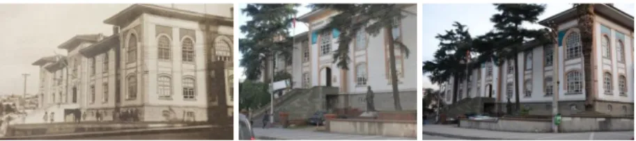
1987). Ortahisar, situated between Yukarıhisar and Aşağıhisar, is located on a flat ground (Bıjışkyan, 1969). Ortahisar has spread over a wide rectangular planned area (Daver, 1987). In the past, the Ortahisar Region was a region where managers, rulers and their dwellings are located, and usually contained administrative units. As the most important example of the construction related to the administration in this region, the Ortahisar Government House is striking.
Feruhan Bey stated that there was a governor palace in Ortahisar in 1847 (Usta, 1999). It is known that during the reign of Governor Emin Muhlis Pasha (1863) the construction of a government house began. However, this structure was burnt in 1865 and lost its function (Goloğlu, 1975), and it is thought that the new construction made in its place was completed at the end of 1860s. It is mentioned in the documents that the Trabzon Government House has been repaired many times from the years 1890 to 1920, and there was a necessity of expanding due to the unmet needs. In 1924, Atatürk saw the old status of the house during his first visit to Trabzon, and the reconstruction of the structure was put on the agenda (Yazıcı, 2008). The building, which served as the Government House until 1987, was opened as a cultural center in 1992 (Yazıcı, 2008). The building, which was built in the years 19201, is the most important example of the 1st National Architectural Movement in Trabzon. The Government House is an important symbol for Ortahisar (Gerçek, 1993) (see Figure 3). Looking at the changes in the structure, it can only be said that the garden wall was rebuilt and the balustrades were removed. The West Garden is now serving as a parking lot. It has also been observed that the rich flora in the West Garden was destroyed over time. Today, it can be said that the structure, used as the Provincial Directorate of Culture and Tourism, is extant with a successful conception of protection, regardless of its surroundings.
For the Fatih Grand Mosque; it was the most important place of worship of the city and is located in Ortahisar District, which was the first Muslim district after the conquest (Tuluk ve Düzenli, 2010). Albayrak (1998) stated that the mosque was built on the ruins of a worship structure belonging to the Roman Period. Immediately following the conquest of Trabzon, the structure was transformed from church to mosque due to conquest policies.
Figure 3. Goverment House in 1950 and today (Bölükbaşı, 2006; Neva Gerçek Atalay Archive, 2013; Neva Gerçek Atalay Archive, 2017)
81
1 It is difficult to establish a clearinformation environment for the year
of construction of the Old
Government House. As Gerçek (1993) indicates that the construction year is in 1920s, Hüseyin Albayrak (1998) states that the year of construction is 1933.
I: 10 .15 32 0/ IC O N ARP. 20 17 .27 – E -I SSN : 21 47 -9380
URBAN CONSERVATION APPROACHES WITH LEGAL REGULATIONS IN TURKEY AND CASE OF TRABZON-ORTAHİSAR
After the Industrial Revolution, with the developing and changing living conditions, migration from the rural area to the cities, the globalization movements of the 1980s, increasing population, some damage to the historic fabric of Turkey has been caused and also irreversible damages have been caused at non-precautionary points. Despite the fact that various possible regulations and laws have been drawn up to minimize the possible damage and to protect the cultural properties, it can be said that the historical and cultural properties in Turkey are not well preserved within the framework of protection.
An attempt has been made for the first time in the name of urban protected area and conservation with the Law No. 1710 on Antiquities dated 1973 in Turkey (Official Gazette, 1973). This was followed by the Law No. 2863 on Protection of Cultural and Natural Properties, which entered into force in 1983. The aim of the law is to organize the necessary activities in order to protect the cultural and natural properties in general meaning, to make decisions and to identify the responsible organizations (Official Gazette, 1983). The Law No. 3194 on Construction, which entered into force in 1985, is seen as one of the leading actors in the formation and shaping of Turkish cities. However, the overall approach of the law overlooks the connection of the conservation areas with new settlements, the functional and social use of the region, and the fact that conversation is an important factor in urban planning studies (Official Gazette, 1985). The Law No. 5366 "Renewal Protection and Retention of Worn-out Historic and Cultural Immovable Properties", which entered into force as of 2005, allows urban conservation areas in Turkey (in capital and its periphery) to be reused in different contexts; mostly touristic, commercial and social (Official Gazette, 2005). The mentioned laws and regulations have played an important role in the transformation of many historical cities in Turkey. The historic city center of Trabzon was registered in 1985 as an urban site (Kahya, 2007). The Ortahisar region, which is included in the 2nd
Figure 4. Ortahisar and Fatih Grand Mosque (URL-3; Neva Gerçek Atalay Archive, 2013)
olu m e 5, Sp eci al Is su e / Pu bl is hed : D ecemb er 2017
urban conservation area, is also being protected under the mentioned laws.
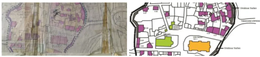
Ortahisar and its immediate surroundings are a region where the Turkish population is intensified and subjected to heavy resettlement after the conquest (Albayrak, 1998). The characteristics of the region have led to the concentration of commercial and social life at this point and have caused Ortahisar to become the center of the city. Considering the population increase and the concentration of migration from rural to urban areas and the historical and spatial development of the city of Trabzon, it is seen that the center of the city is located towards the east of the city (Atatürk Square) from Ortahisar and its immediate surroundings. While the city maintained its physical growth in the direction of the East, the historic texture of Ortahisar maintained its proximity to this new center, but it could not avoid losing its role as a center of the city. The conservation work done in the region was limited only to the historical texture in Ortahisar and an isolated approach of protection has been applied, ignoring the visual and physical relations with other parts of the city and its immediate surroundings. For example; The French architect and urban planner Jacques H. Lambert, who visited the city in 1937, worked on a series of studies to prevent losses in the historic fabric (Ortahisar), which he foresaw for the future, and prepared a city planning programme. The most striking point in this program is that while Ortahisar is growing in east-west axis, the greatest threat to historic texture is the axles and their connections that will serve the living spaces. This deficiency, which was put forward in 1937, did not find a response in practice and came back to the agenda again with a competition opened by the Bank of Provinces in 1968 (Zorlu et al., 2010). In the project that won the first prize in the contest, the ancient city was designated as a protocol area and tried to be preserved. The third planning study belonging to the region was started in 1989 after the registration of the 2nd urban conservation area in 1985 with the approval of the conservation development plan (Kahya, 2007) (see Figure 5). Until the 2000’s, the main road connecting the west of the city with the new center of Ataturk Square was the meandering axis which passes through the middle of Ortahisar (Zorlu et al., 2010). The Tangent Road (Flying Road2), which is the alternative to Ortahisar's main axis, which was mentioned in Lambert's plan for the first time in the 1930's and which was put into practice in 2002, has fallen in front of the historic walls of Ortahisar with its 8 carrier pillars at a height of several meters and has shadowed Ortahisar and city silhouette. This shows that the concept of protection applied in the region is carried out independently of other points of the city and also without visual, social and functional relation.
83
2 “Flying Road” is a term used for the
Tangent Road in the article “Tanjant Yol Nereden Geçecek?”, which was published in Journal of Architecture, volume 250, in 1992.
I: 10 .15 32 0/ IC O N ARP. 20 17 .27 – E -I SSN : 21 47 -9380
Today, the Tangent Road undertakes the majority of the density of the main axis passing through Ortahisar. Therefore, Ortahisar, which was a place where administrators, rulers, administrators’s and managed’s houses and the Government House which functioned for 60 years existed once, now become an idle zone which is not used. The Ortahisar region has become an area where middle and lower income groups have lived because of the evolving and changing living conditions, and this residential area has been abandoned by the owners and leased to low sums.
It is seen that the structures in the 2nd urban conservation area which are considered worthy of protection in the conservation development plan of 1988 are still recorded as protected in today's conservation development plan (see Figure 5).
Comperative Photos of The Area: From Past to Present
In the old photograph3, it seems that the old texture, which is harmonious with others and has a beautiful continuity, has been deteriorated today. The reason for this is the concreted apartment building (6 floored) built in the 1960s instead of traditional housing, which respects its surroundings with its proportions and measures (Interview with Bekir Gerçek4, 2017).
As stated by Gerçek (1990), there was a coffeehouse on the bridge of Tabakhane with a view of the city walls and valleys, and leather shops just below it. In the historical photograph, the mentioned coffee shop which rises above the carriages at the end of the bridge and the shops of the leather dealers under the bridge can be seen. However, in today's photographs, it is observed that these structures do not exist today. In the old photograph, it is seen that the building on the left side of the bridge is known to have
Figure.5..Conservation Development.Plans.of.1988 (Anonymous, 2017c) and today
Figure.6..A.View.from Tabakhane to Ortahisar; 1950’s3 and Present
(URL-3; Bahar Karakaş Archive, 2013; Bahar Karakaş Archive, 2017)
Figure 7. An Overview from Mimar Sinan Road to Tabakhane; End of 1940’s and Present (URL-3; Neva Gerçek Atalay Archive, 2013; Neva Gerçek Atalay Archive, 2017)
84
3The years given for the old
photographs have been shaped by the estimates of the users of the site for at least 80 years and do not give a definitive historical dates.
4Bekir Gerçek was born in
Trabzon-Ortahisar in 1948 and is still living in Ortahisar neighborhood. Architect Bekir Gerçek worked as the executive director of the Chamber of Architects Trabzon Branch for 20 years and as a member of the board between 1973-2013.
olu m e 5, Sp eci al Is su e / Pu bl is hed : D ecemb er 2017
collapsed in 2016, even though it has a historical value. In today's photograph, it is noteworthy that the last building mass of the Tabakhane Mosque is incompatible with the surroundings. It is also said that only the minarets of the mosque came up to today. It can be seen that the structure of the region in the 1940’s was in harmony with the surrounding area and stayed at a certain gabarite border; however today, the structures are as high as possible and adversely affect the cityscape.
When looking at the old photograph, the Tabakhane Bridge which is the exit door of the city to the East, Olcay Printing House (It is claimed to be the first printing house in Trabzon), the building rising above the carriages and the leather shops (debbağhane) whose name are coming from the name of the bridge can be seen. The concept of park and garden developed with the Republic was applied in major points in Trabzon. Flower Garden located under the Tabakhane Bridge and Atapark can be shown as the examples of park-garden understanding during the Republican Period (Interview with Bekir Gerçek, 2017). The biggest change that can be easily noticed when comparing two photographs is that the pavilion used as Olcay Printing House is destroyed for years and the balcony has collapsed.
When going down to the Tabakhane Bridge, it is known from the users that there are some shops on the right side of the bridge (Interview with Bekir Gerçek, 2017). When looking at the wall passing to Government House from the place where the flower garden is located, the remains of the columns that are estimated to be the carriers of these shops can be seen. The presence of the shops which are mentioned is also present in the old photographs.
Figure 8. Top view of Tabakhane Bridge; 1930’s and Present (URL-3; Bahar Karakaş Archive, 2013; Bahar Karakaş Archive, 2017)
Figure 9. The building of the mentioned Shops and the Current Carrier Traces of the mentioned Shops (URL-2; Bahar Karakaş Archive, 2013)
I: 10 .15 32 0/ IC O N ARP. 20 17 .27 – E -I SSN : 21 47 -9380
In the old photograph, the structures seen in the south from the culvert of the bridge are the original Trabzon Houses with triangular pediments and inner hall plan type. Until 2016, unidentified and non-significant apartment-like buildings were found causing conurbation in this region. In 2016, all these unqualified buildings were demolished as part of the Tabakhane Valley Urban Transformation Project, which was carried out by the Housing Development Administration (TOKİ) and the Trabzon Metropolitan Municipality and the urban transformation project is still continuing nowadays. It has generally been observed that the bridge has not been altered much and has come up to date in a proper manner.
Despite the changing conditions, the route from Tabakhane Bridge to Ortahisar is still a very important transportation trace. Between these two photographs, there is not much change in terms of functional and facade character in the context of structures.
The road passing Ortahisar between the two bridges in the east-west direction leads directly to the Sarayatik Mosque Street from opposite of the Government House. The entrance of this street can be seen in the photographs. One of the biggest differences between the two photographs is the ruined southern facade of the Olcay Printing House. It is also seen that the door space of Olcay Printing House has been closed. It was learned after the meeting with the owner that, due to a change of the function, the old entrance gate located on the south façade of the building, whose upper floor used as a residence, was closed. It is seen that the two
Figure 10. Northern Facade of Tabakhane Bridge; 1920’s and Present (URL-3; Bahar Karakaş Archive, 2013; Bahar Karakaş Archive, 2017)
Figure.11..Departing.from
Tabakhane Bridge to Ortahisar; 1960’s and Present (Gerçek 2011; Neva Gerçek Atalay Archive, 2013; Neva Gerçek Atalay Archive, 2017)
Figure 12. Opposite direction of the Government House; 1970’s and Present.(Gerçek.2011,.Bahar Karakaş Archive, 2013; Bahar Karakaş Archive, 2017)
olu m e 5, Sp eci al Is su e / Pu bl is hed : D ecemb er 2017
historical buildings next to the Olcay Printing House have been functionally altered (Kahya, 2007) and have been properly preserved and reached today.
When looking at the old photograph, the bread oven which is compatible with the surroundings with vertical and façade proportions and the coffee house of the neighborhood next to the oven can be seen. When looking at today's photographs, it can be seen that the reinforced concrete apartment, built in the place of bread oven in the 1960's, shows a structure which is in contrary to the old city silhouette, with its measurements and proportions (Interview with Bekir Gerçek, 2017). This is thought to be one of the multi-storey apartment buildings, built in the region, in line with the decisions on the implementation of construction servitude of the Property Law, which was enacted in 1965 (Official Gazette, 1965). In addition to this, there is a two-storey building of Karabacak Construction that is completely unrelated to its surroundings with the choice of colour and materials.
It is seen that the upper floor of the traditional Trabzon residence on the left side of the picture taken in 1960, is destroyed today. Apart from this, there has not been much change in the context of gabarite and façade editing of constructions. Zağnos Road, which is seen in the photo, is continuing from right after the western entrance of the old city (Zağnos Gate) to the first crossroad behind the Mosque. While the İç Kale Road continues to the south from crossroad, the Government Road (today called Mimar Sinan Caddesi) starts towards to the north. Fatih Grand Mosque is located about two and a half meters below from Zağnos Road. According to Anthony Bryer's assertion, the Bridge of Zağnos, which is on the west of the Mosque rose steadily with the change in history and reached today's altitude (Bryer and Winfield, 1985). The rise in this bridge also affected the altitude of the road and the Mosque remained in the hole. And nowadays, the restoration work of Fatih Grand Mosque is still going on.
Figure 13. A View to the Fatih Grand Mosque from the Government House; 1950’s and Present (Bekir Gerçek Archive, 2013; Bahar Karakaş Archive, 2013; Bahar Karakaş Archive, 2017)
Figure 14. View of Fatih Grand Mosque from the Western Front of the Government House (1960’s) and Present (URL-3, Bahar Karakaş Archive, 2013; Bahar Karakaş Archive, 2017)
I: 10 .15 32 0/ IC O N ARP. 20 17 .27 – E -I SSN : 21 47 -9380 CONCLUSION
The cities, which are the shelters of the society, are a totality of culture with their historical past, with their inhabitants and with their structures, in other words, with their architectures (houses, public buildings, sacred buildings, museums, bridges, arches, castles, walls, monuments etc.). In ensuring the continuity of cultural integrity, the role of the architectural structures, which bridges between the past and the future and also called cultural heritage, is great. Keeping these kind of values alive is important for the urban users to feel the belongingness to the city and also to convey this feeling to future generations. For these reasons, historical fabrics must be properly preserved and kept alive for the continuity of city identity and memory. Being historical and registered is not a sufficient reason to protect the structures situated on the historical fabric. To protect these structures, it is necessary to assess them in terms of their importance and location in the historical environment, instead of coming up with specified proposals for each building.
In the case of Trabzon, Ortahisar region and its immediate surroundings of the city are centers with historical continuity. However, urban conservation approaches of the city authorities and the practices they have carried out in this context led to the deterioration of the visual, functional and historical continuity in the historic city center. In the study conducted on the main axis between Tabakhane Bridge and Fatih Grand Mosque, it was observed that the public buildings in the area were protected more qualified than the civil architectural structures. In addition, in the historical center, it is noteworthy that the green touch has been destroyed by unconscious interventions; the new reinforced concrete building heights have not respected the historical texture and are overwhelming. The 1965 Property Law and the 1985 Construction Law have caused the mentioned situations to occur. After the said legislations, the city's destruction was accelerated and the city's identity was lost due to the contradiction to the principles of urbanism while doing restructuring.
In terms of conservation approaches carried out on a single building scale, the values that the Ortahisar historical center holds must be considered as a whole without being separated. In addition to the rules, requirements and the technical interventions, it should not be ignored that the main user of the city is the people and if the continuity of the city identity and memory is ensured, the users will feel belongingness, own the city and take an active role with responsibility in the matters of the city.
olu m e 5, Sp eci al Is su e / Pu bl is hed : D ecemb er 2017 ACKNOWLEDGEMENTS
This article is prepared by expanding the proceeding presented in the ICONARCH III, held at Selçuk University in May 11th-13th, 2017.
REFERENCES
Albayrak H. (1998). Trabzon Ortahisar ve Çevresi, Trabzon Municipality Cultural Publishing:72, Trabzon.
Anonymous, (2017a). ‘23.02.1979 Dated Report’, Trabzon General Directorate of Cultural and Natural Heritage Archive.
Anonymous (2017b). ‘19.07.1985 Dated 1311 Numbered Decision’, Trabzon General Directorate of Cultural and Natural Heritage Archive.
Anonymous (2017c). ‘Second Urban Protection Area Trabzon Reconstruction Plan for Protect’, Trabzon General Directorate of Cultural and Natural Heritage Archive. Bıjışkyan, P. M. (1969). Karadeniz Kıyıları Tarih ve Coğrafyası
1817-1819, Istanbul University Faculty of Literature
Publishing, Istanbul.
Bölükbaşı, A. (2006). Anılarda Trabzon, vol. 2, Serander Publishing, Trabzon.
Bryer, A. and Winfield D. (1985). The Byzantine Monuments and
Topography of the Pontos, vol.1, Dumbarton Oaks
Publication Office, Washington.
Daver, B. (1987). “Trabzon Tarihine Kısa Bir Bakış”, Trabzon
Journal, 1: 8-10.
Gerçek, B. (1990). “İki Köprü, Bir Şehir”, Trabzon Journal, vol.4, pp.67-72., Ajans Türk Publishing, Ankara.
Gerçek, B. (1993). “Eski Bir Başkent Ruhu Yaşanır Ortahisar’da”,
Trabzon Journal, vol.7, pp. 56-66., Nurol Publishing,
Ankara.
Gerçek B. (2011). Başkentin Baş Mahallesi Ortahisar, 1.Press, Heyamola Publishing, İstanbul.
Goloğlu, M. (1975). Trabzon Tarihi, Kalite Publishing, Ankara.
Interview with Bekir Gerçek, January 20, 2017.
Kahya, N. C. (2007). Doğu Karadeniz Bölgesi Kentsel Sitlerinde
Koruma Sürecinin Değerlendirilmesi, PhD Thesis, KTU,
Enstitute of Science, Trabzon.
Karpuz, H. (1990). Trabzon, Kültür Bakanlığı Publishing/1127,
Mas Publishing, Ankara.
Tuluk Ö. İ. and Düzenli H. İ. (2010). Trabzon Kent Mirası-Yer Mekan
Hafıza, 1. Press, Klasik Publishing, İstanbul.
URL-1 http://www.kulturvarliklari.gov.tr/TR,44799/illere-gore-korunmasi-gerekli-tasinmaz-kultur-varligi-i-.html, (date of connection: 10 January 2017)
URL-2 http://wowturkey.com/forum/viewtopic.php?t=50979 &start=5 (date of connection: 2013)
URL-3 https://www.facebook.com/TrabzondaNostalji/?fref=ts, (date of connection: 2013)
I: 10 .15 32 0/ IC O N ARP. 20 17 .27 – E -I SSN : 21 47 -9380
Usta V. (1999). Anabasis’ten Atatürk’e Seyahatnamelerde Trabzon, Serander Publishing, Eser Ofset, Trabzon.
Official Gazette (1965). Kat Mülkiyeti Kanunu, “Property Law”, no 12038, July, 2, 1965.
Official Gazette (1973). Eski Eserler Kanunu, “Ancient Monuments Law” no 14527, May, 6, 1973.
Official Gazette (1983). Kültür ve Tabiat Varlıklarını Koruma Kanunu, “Code of Protection of Cultural and Natural Properties”, no 18113, July, 23, 1983.
Official Gazette (1985). İmar Kanunu, “Construction Law”, no 18749, May, 9, 1985.
Official Gazette (2005). Yıpranan Tarihi ve Kültürel Taşınmaz Varlıkların Yenilenerek Korunması ve Yaşatılarak Kullanılması Hakkında Kanun, no 25866, July, 5, 2005. Yazıcı, N. (2008). “Trabzon Örneğinde Tanzimat’tan Cumhuriyet’e
Hükümet Konağı Binaları”, “Government Office Buildings in Trabzon Province From The Tanzimat Era to the Republic Period”, The Journal of International Social Research, 1(5), 943-959.
Zorlu et al., (2010). “Kent Kimliği: Tanjant ve Karadeniz Sahil Yollarının Trabzon Kent Kimliğine Etkileri”, Mimarlık Journal, 352, 54-59.
Resume
Neva Gerçek Atalay is a research assistant of Architecture at the Gazi University of Ankara. Gerçek Atalay received her Master of Science Degree from the Karadeniz Technical University of Architecture, and Bachelor of Architecture Degree from same university in Trabzon. She is currenty continuing her Ph.D. in Architecture at the Gazi University. Research interests; architectural design, architectural design theories, architectural education.
Bahar Karakaş is a research assistant of Architecture at the Karadeniz Technical University of Trabzon. Karakaş received her Master of Science Degree from the Karadeniz Technical University of Architecture, and Bachelor of Architecture Degree from same university in Trabzon. She is currently continuing her Ph.D. in Architecture at the Karadeniz Technical University. Research interests; the republican architecture and ideology in Turkiye, ethos of architecture in Turkiye and Trabzon.