Istanbul Policy Center, Sabanci University, Istanbul [email protected]
Dept. of Political Science and International Relations, MEF University, Istanbul
> Turhan, E., and A. Kibaroglu, “Political Economy and Political Ecology of the Turkish Section of Asi River Basin”, in Water Resources Management in the Lower Asi-Orontes River Basin: Issues and Opportunities, Geneva: Graduate Institute of International and Development Studies; Istanbul: MEF University, 2016, p. 19–30.
1. Introduction
In his picturesque 1991 novel on the Levant, aptly titled “Ports of Call” (Les
Échelles du Levant), acclaimed Lebanese-French author Amin Maalouf asks: “Is that period, where people of different origins used to live side-by-side with lan-guages mixing, a remembrance of the past? Is it a messenger for the future? Those who have seen this dream, are they the ones stuck in the past or those who dream of the future? I cannot respond this but my father believed in it”. In this brief extract,
Maalouf refers to a time where the borders have been more porous and transient not only between people but also between landscapes in the Levant. Asi River is a prime example of such a landscape.
The Turkish section of the Asi River Basin is a historically contested territory with not only a rich cultural/historical heritage and rapidly changing population dynamics but also a region with a high value-added agricultural production. Hatay – the city where Asi River enters Turkey – is surrounded by the Syrian border to its east and the Mediterranean Sea to its west while also forming the southernmost part of Turkey. This study focuses on the political economy/political ecology of the Turkish section of the Asi River Basin with a focus on population, economy, gov-ernance and agriculture as the key sector in the region vis-à-vis the Asi as a local socio-ecological metabolism.
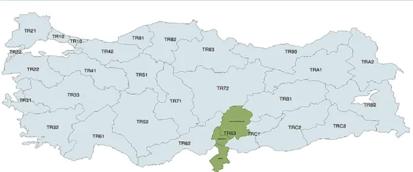
Hatay is clustered along with Kahramanmaras and Osmaniye classified as TR63 NUTS (Nomenclature of Territorial Units for Statistics) since 2002 in order to improve statistical data collection in line with EU standards, to keep up with Tur-key’s bid for the membership of the EU (Sobacı 2009). The NUTS system includes 12 Level I categories (with population exceeding 3 million people), 26 Level II cat-egories (with population between 800.000 and 3 million people) and 81 Level III categories (with population between 150.000 and 800.000) (see Figure 1). Hence, majority of the socio-economic development figures used in this study are derived from statistics for the TR63 region, which includes Hatay, Kahramanmaras and Osmaniye. Within the TR63 region covering these three cities, Hatay appears as a key economic center having 16 districts. Hatay is an economic center in the region with two ports of entry with Syria (Cilvegozü and Yayladagi) and is a major trade route with the E-5 highway connection that links Europe with the Middle East, passing through it. And yet it has an urbanization rate of 58.6% well below
the national average of 77.3%. Hatay as a province has a surface area of 5867 km2, approximately half of which is agricultural land (DOGAKA 2014).
After forming the Turkish-Syrian border for 31 km, the Asi enters Turkish soil from the village of Apaydin and travels 97 km within the Turkish territory before it reaches the Mediterranean at the Samandag district (Provincial Directorate of Envi-ronment and Urbanization 2013). The Turkish section of the Asi River Basin has an area of 18,972 km2 making up for 50% of the basin area with 46% contribution to annual runoff (Scheumann et al. 2011). It is estimated that the annual water poten-tial of the Asi in the Turkish territory is 1200 hm3/year with an average flow rate of 67 m3/s (Provincial Directorate of Environment and Urbanization 2013:22). All in all, the Asi serves a total estimated population of 5.86 million in three countries (Turkey, Syria and Lebanon) (UN-ESCWA and BGR 2013).
Figure 1 – Map of TR63 region (Hatay-Kahramanmaras-Osmaniye)
(Source: DOGAKA 2014)
2. Downstream Asi River basin as a local socio-ecological metabolism
2.1. Population
Hatay has historically been a port of entry and transit route for civilizations. Located at the border between Syria and Turkey but also forming the easternmost Mediterranean coast of Turkey, Hatay proved to be a gateway for different popula-tion movements over centuries. As of 2013, the total official populapopula-tion of Hatay stood at 1.506.066 (TUIK, 2014). Being higher than the Turkish national average of 41%, 46% of Hatay’s population is under 25 years of age making it a young and vibrant city. Average household size in the city is 4.11 people, placing it at the 19th rank in national figures on household size (ibid).
The population density in Hatay stands at 258 people/km2 (Turkish average being 100 people/km2) and makes it a highly populated region vis-à-vis its land size (TUIK 2014). While the downstream Asi basin is an epicenter drawing people due to the attractive economic opportunities it provides, it is also a region laden with increasing uncertainty in both its climatic characteristics as well as its chang-ing demographics. It should be noted that in 2012–2013, Hatay was a city with a net outward-migration, which may turn out to be a long-term pattern for its natives (TUIK 2013).
The exacerbating conflict in Syria has led to a massive influx of refugees since the arrival of the first group on 29th April 2011. Figures of DOGAKA (Eastern
Mediterranean Development Agency) suggest that 92% of 351.435 entries to Turkey in 2012 were undertaken by Syrian nationals (DOGAKA 2014). Hatay Governor Ercan Topaca stated in a recent speech that there are about 245.000 Syrians regis-tered in the city, now constituting 15% of the provincial population (Hürriyet 2015). The total number of Syrian nationals living in cities country-wide stands at about 1.938.999 people (UNHCR 2015). Given the current turmoil in Syria, one also has to be cautious of particularly volatile remarks in the literature on political geog-raphy of the region, that argue that Arab ethnic dominance in the region after the annexation of Hatay to Turkey on 29 June 1939 remains an obstacle to “national unity” (Atasoy et al. 2013). Given the current conditions, population-wise uncer-tainty might have long-term effects on the economy and on natural resources of the region.
Significant changes came to being in local governance in Hatay with the entry into force of new legislation (No: 6360) on metropolitan municipalities (Adıgüzel and Tek 2014). A key change that came through in the administrative governance of the city has been a rise in the number of Hatay’s provinces (including the city center) from 12 to 16.
With these new regulations in place, while metropolitan municipality borders are drawn closer to provincial borders at the same time there appears significant new questions for local governance. This is most visible in the cases where new munic-ipal configuration brings up new municmunic-ipal tax burdens for the citizens living in rural areas. Adıgüzel and Tek (2014) underline that this change does not only split administrative units to alter the voting patterns (creating disadvantage to opposition parties) but also consolidates zoning and planning powers under the metropolitan municipality hence creating an obstacle for achieving decentralized governance and participation. These authors warn that this situation may also lead to a democratic deficit in urban planning and administration.
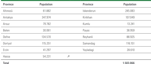
Table 1 – Population of districts of Hatay (without Syrian migrants, TUIK 2014)
Province Population Province Population
Altınozü 61.882 Iskenderun 245.083 Antakya 347.974 Kirikhan 107.049 Arsuz 79.782 Kumlu 13.241 Belen 30.061 Payas 38.959 Defne 134.570 Reyhanli 88.925 Dortyol 115.251 Samandag 116.151 Erzin 41.297 Yayladagi 28.610 Hassa 54.231 k Total 1.503.066 2.2. Economy
According to the Ministry of Development’s (2013) most recent socio-economic development report, Hatay ranks the 46th out of 81 cities in Turkey. As such, it is placed in the Tier-3 cities category in the socio-economic development in Turkey. Hatay’s share in the public budget summed up to 304.093.000 Turkish Liras (approximately 110 million euros with the exchange rate of 1€ = 2.76TL) in 2010. One can see that the lion’s share of these public funds for Hatay, were
spent on transportation (43,10%) followed by education (22,28%), agriculture (11,88%) public health (8,52%) and the rest of public utilities (10,98%) including infrastructure, drinking water provision, electrification and so on (Hatay Valiligi 2011). As of 2012, the population served with running water was 1.118.743 (Provincial Directorate of Environment and Urbanization 2013) in a city of 1.506.066 (TUIK 2014).
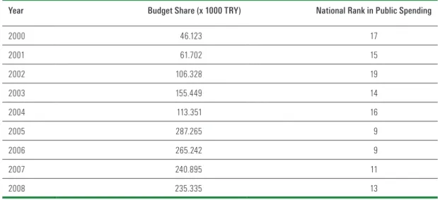
Hatay, similar to the rest of TR63 region, also has a low employment rate, which stood at 40.3% in 2013 (TUIK 2014). Work force participation by graduates with higher education was 13.8% in the city, lower than the national average of 18.2%. One can possibly suggest that the high level of unemployment is also linked to the educa-tion levels in the province. As such, 2011 figures for employment reveal that 25.3% of the provincial population is employed in agriculture, 24.3% in industry and 50.4% is employed in services (DOGAKA 2014). These figures also relate to public spending in key public services such as education, health, utilities etc. Table 2 below shows that the public spending in Hatay has been steadily increasing since 2000s.
Table 2 – Public Spending in Hatay, 2000-2008
Year Budget Share (x 1000 TRY) National Rank in Public Spending
2000 46.123 17 2001 61.702 15 2002 106.328 19 2003 155.449 14 2004 113.351 16 2005 287.265 9 2006 265.242 9 2007 240.895 11 2008 235.335 13 (Hatay Valiligi, 2011)
According to TUIK (2014), gross added economic value in TR63 region cover-ing (Hatay, Kahramanmaras and Osmaniye) in 2011 was 5,904 USD/capita mak-ing it significantly lower than the Turkish national average, which stood at 9,244 USD/capita that year. These figures show that TR63 region is a producer of prod-ucts with a low value-addition, which makes it a relatively cheap manufacturing region. According to 2012 figures, 54% of employment in the TR63 region is infor-mal (DOGAKA 2014). This number goes up to 93% in agriculture. Hatay ranks 7th in Turkey in terms of overall import figures with net worth of imports equaling to 4.420.192.000 USD (Ministry of Development 2014).
Hatay is also increasingly becoming a key energy hub, particularly with wind-energy investments that ranks four in Turkey in terms of installed capacity (178 MW). However the city also has development plans for 5 thermal power plants (1 natural gas conversion, 4 coal-fired power plants) in the pipeline, which may have potential adverse effects on water bodies in the region including the Asi due to high amount of cooling waters they require. Moreover while there are two hydro-power plants (HPP) operating in Hatay currently, there are plans for development of 5 additional HPPs with a total capacity of 35,70 MW (DOGAKA 2014). Designa-tion of the eastern Mediterranean region of Turkey as an energy hub would
inevita-bly bring serious ecological consequences both to the natural ecosystems and social systems in the region.
A recent assessment on the economic impacts of Syrian migration into Hatay found out that without the migrant in-flux, imports would have been the same whereas exports from the region would have increased by 24% (ORSAM 2015). The same study (using a perception survey with n = 94 in Hatay) also concluded that prices of goods in the city went up after the arrival of Syrian migrants. Although demographic characteristics (age, gender, profession etc.) of the partici-pants of this survey are not clearly defined, the authors of this study suggest that 78% of the respondents in Hatay perceived a downfall in wages and increase in rents with the arrival of the Syrians (ibid). Nonetheless an econometric assessment by Akgündüz et al. (2015) found that while housing and to a lesser degree, food prices increased, employment rates of natives in various skill groups remained largely unaffected in the migrant-receiving cities of Turkey. Although this seems to be the case for the formal economy, as Arslan et al. (2015) showed recently illegal economic activity such as drug trafficking rose exponentially after the onset of the conflict in Syria with an increase of 84% from 2010 to 2011 followed by further sig-nificant increases in 2012 and 2013.
2.3. Governance
The 2015-2019 Strategy Report prepared by Hatay Metropolitan Municipality suggests that among the strengths of this administrative division are the prolifer-ation of non-governmental organizprolifer-ations and citizen ownership [on the admin-istrative matters] (Hatay Büyüksehir Belediyesi 2014). Considering the potential adverse ecological impacts in the region due to rapid industrialization and new mobility patterns, it is worth noting that this strategy foresees a gradual decline in investments for environmental protection and control between 2015 and 2019 while increasing social assistance and public services approximately three-fold during the same period. Hatay is a vibrant city in terms of civil society activities. As of the end of 2013, there were 1116 formally established associations (DOGAKA 2014) with 77.145 members and 98 foundations1 of all sorts (religious, cultural, educational etc.) in Hatay.
A striking issue with regard to governance in Hatay, is the high number of “strat-egy” documents produced by various public institutions. It will not be far-fetched to say that almost all public institutions (Governorship, Special Provincial Admin-istration, Metropolitan Municipality, Regional Development Agency etc.) prepared strategy documents with participatory2 approaches. Organized in a similar partic-ipatory fashion, the Asi River Basin Management Committee was established and held its introductory meeting at the end of 20133. This river basin management institution, which is composed of both public institutions (governorships, univer-sities, relevant ministerial bodies) and irrigation unions, NGOs, is a significant step in the integrated planning of downstream Asi Basin within the framework of National Basin Management Strategy (2014-2023) (entered into force on 04.07.2014, Official Gazette No: 29050). This body that aims to integrate efforts for water man-agement in the Asi basin and in its adjacent provinces, held its latest annual meet-ing in mid-April 2015 chaired by the deputy-governor of Hatay (DSI 2015a).
1 http://hatay.vgm.gov.tr/sayfa.aspx?Id=668&Bolge=13
2 For example, the strategic plan of the metropolitan municipality involves satisfaction surveys with citizens (n=722) as well as with its own employees (n=86).
3. Access to water and sanitation
3.1. Pollution in downstream Asi
A key topic of concern in the Turkish section of the Asi is water pollution. Ear-lier assessments on the water quality in Hatay yielded a “low-level of pollution” cat-egorized as 2nd level pollution according to Ministry of Environment’s classification (Tasdemir and Goksu 2001). However, more recent assessments show that pollution in Asi reached high levels by making it a water body with 4th level pollution (Pro-vincial Directorate of Environment and Urbanization 2013). Water Pollution Con-trol Bylaw (No: 25687, entry into force: 31.12.2004) defines 4th level polluted waters as “highly polluted surface waters”. A study undertaken between February 2006 and August 2007 revealed that Asi enters Turkey with the above threshold (mg/L) content of pollutants such ammoniacal nitrogen (NH3-N) known as poisonous to humans, nitrate nitrogen (NO2-N) posing health risks for drinking water, zinc (Zn) and potassium (K) (Korkmaz and Karatas 2009: 32). For example, while the accept-able threshold level for NH3-N in rivers is 0.5 mg/L, observations showed that in February 2006 this level was 6.1 mg/L at Asi River’s entry point to Turkey (ibid.). Ammoniacal nitrogen originates from landfill leachate and also found in waste products, such as sewage and liquid manure linked to uncontrolled disposal of human and animal waste into flowing water bodies. These findings call for a spe-cific caution on water pollution in the downstream Asi especially given that 68% of the municipal population is served with a sewage system and 37% of the municipal population is served with a wastewater treatment plant. (DOGAKA 2014).
Asi River Delta also faces significant pollution not the least from upstream sources including not only industry and agriculture but also household wastes (Ozsahin 2010). Ozsahin and Atasoy (2015) further contend that the main problem in the lower Asi Basin is the misuse of soil and shortcomings in land use/land use change. Such shortcomings inevitably lead to soil erosion, which in turn deteriorate the water quality and severely impact agriculture in the region. As these authors suggest, such problems can be remedied by better use of advanced agricultural and irrigation techniques, which do not solely aim at boosting the yield and expand agricultural production. This requires an integrated and holistic approach to water and land management, examples of which can be seen in novel approaches such as the Nexus approach (Bizikova et al. 2013).
3.2. Irrigation
Irrigation constitutes a key strategic use of the Asi River’s water along with energy production and ecosystem self-replenishment. As Scheumann et al. (2011) report, the Turkish section of the river already has four irrigation projects in oper-ation, two in the pipeline and six under planning. Currently the extent of irrigated areas in Hatay stand at 22,086 ha with new projects possibly adding 79,100 ha (3 projects, Amik-Afrin, Amik-Tahtakoprü and Asagi Ceyhan-Aslantas irrigation pro-jects) to this number (DSI 2015b). Considering that the total irrigable agricultural land size in Hatay is 206,553 ha (Provincial Directorate of Environment and Urban-ization 2013), this means that completion of hydraulic works in downstream Asi River would bring irrigation to 48% of all irrigable land in the region.
3.3. Flood protection and coastal erosion
Hatay is a flood-prone city with a damaging history of floods (see Balaban 2009). Heavy precipitation and unplanned urbanization trigger flood events. Exter-nal factors such as dam breaks (like in 04.06.2002 in Syria) or rapid water releases from reservoirs (without early warning) to protect Syrian lands from inundating, also caused significant losses in Turkey in the past. Hence, in order to avoid highly
damaging floods on the lower Asi, a protocol was signed basin between Turkey and Syria on flood early warning system on 27.06.2008 (Selek 2014). This proto-col ensured that two flow measurement stations, respectively at Shaghur Bridge and Derkus Town, were established. However initially due to technical problems and later due to political turmoil, this system, which would be able to receive early flood warning signals 60 hours in advance, was not operationalized (ibid.)
Another major issue in downstream Asi is the coastal erosion in Samandag delta, where the river reaches the sea (Ozsahin 2010). Since water-retention structures not only retain water but also transport sediments, it is highly likely that hydraulic structures both in the Turkish section and the Syrian section of the Asi contribute to coastal erosion. In addition, the uncontrolled sand extraction from the delta for the construction sector is also likely contributing to coastal erosion.
Eventually hydraulic structures constructed to hold water for irrigation or energy purposes, inevitably contribute to the deterioration of natural landscapes in the downstream, most visibly, in the region where the Asi reaches the sea.
3.4. Public health and drinking water
Public health is a key aspect of the governance in the Turkish section of the Asi Basin. A key indicator is the rate of birth, which stands at 20.1 per thousand inhab-itants in Hatay in comparison with the Turkish national average of 16.9 per thou-sand inhabitants in 2013 (TUIK 2014: 44). On the other hand, while the national average for child mortality is 11.6% figures for Hatay reveal this indicator as 14.1%. Average municipal drinking water extraction in Hatay is 227 litres/cap.day (TUIK 2014), while the coverage of villages with potable water connection is 92% (DOG-AKA 2014). Current hydraulic works in “Greater Karacay Drinking Water Project” is anticipated to provide potable water for 17 municipalities until 2037. DOGAKA (2014) report that the public health spending in Hatay has been steadily decreasing from 11.18 million USD in 2008 to 4.37 million USD in 2012 at fixed prices4. None-theless national public health spending rose from 515.8 million USD to 710.9 mil-lion USD in the same period (DOGAKA 2014). A study on out-of-the-camp ref-ugees in Hatay (covering 114 households with 159 Syrian families) revealed that “43% of families fear exposure to animal excreta, while the same percentage of families have cited open defecation as a serious risk and 38% worry about the lack of garbage collection” (STL, 2013). Nearly 83% of the respondents mentioned that they had access to safe water whereas 98% told that they lacked access to hygiene supplies (soap, diaper, detergent etc.) due to prohibitive prices (ibid).
4. Agriculture in the downstream Asi River basin
Hatay, that lies at the downstream section of Asi Basin, is a key agricultural pro-ducer in Turkey. According to DOGAKA (2014b), Hatay hosts a total of 254.983 ha of agricultural land 130.892 ha of which is sown. Nearly 34.847 ha of this sum is dedicated to vegetable growing while 82.478 ha is used for fruit cultivation (ibid.) Majority of these agricultural lands in Hatay are concentrated in Antakya and four other districts, including Kirikhan, Reyhanli and Altınozü. Districts such as Dor-tyol, Erzin, Samandag and İskenderun, however, emerge as main horticulture pro-ducers in the province vis-à-vis total agricultural land use in Hatay. These latter districts focus on agricultural outputs with higher value-added products such as cit-rus (DOGAKA 2014). In 2013, Hatay had 2.2% share of the agricultural production in Turkey, summing up to 2.7 billion TL worth (TUIK 2014).
The region also hosts olive groves with an area of 50.975 ha producing 195.620 tons/year, which constitutes 11% of the national olive oil input (Hatay Provincial 4 1 USD = 3.04 TRY on 29.09.2015
Directorate of Food, Agriculture and Livestock 2013). Hatay was also responsible for 37% of parsley, 29% of tangerine, 13% of lettuce and 10% of carrots produced in Turkey in 2012 (ibid.).
As a result, Hatay’s economic contribution to national gross agricultural produc-tion in 2012 stood at 2.965.447.000 Turkish Lira (approximately 1.070.000 euros with an exchange rate of 1 € = 2.77 TRY in 2012) making up for approximately 1.5% of economic value-added in Turkey’s overall net agricultural production (ibid.). Moreover economic value of agricultural exports from Hatay accounts for nearly 33% of the overall economic value of exports (DOGAKA 2014).
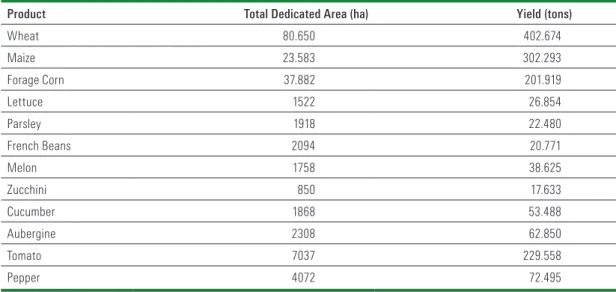
Table 3 – Main crops having high importance for the agricultural economy in Hatay
Product Total Dedicated Area (ha) Yield (tons)
Wheat 80.650 402.674 Maize 23.583 302.293 Forage Corn 37.882 201.919 Lettuce 1522 26.854 Parsley 1918 22.480 French Beans 2094 20.771 Melon 1758 38.625 Zucchini 850 17.633 Cucumber 1868 53.488 Aubergine 2308 62.850 Tomato 7037 229.558 Pepper 4072 72.495
(Hatay Provincial Directorate of Food, Agriculture and Livestock, 2013)
Table 4 – Extent of irrigated farmland in Syrian and Turkish sections of Asi Basin (in hectares)
Year Syria Turkey
1960 90.000 64.000 1970 124.000 68.000 1980 164.000 86.000 1990 155.000 95.270 2000 227.000 110.224 2006 268.000 125.645 2011 N/A 176.515
(Korkmaz and Karatas 2009; DOGAKA 2014)
A key issue of concern in downstream Asi basin is the double-edged problem of increased pollution load and decreased flow rate. This has significant conse-quences for the agriculture in the region. Korkmaz and Karatas (2009) report that there has been a decrease in cotton yield in the region due to this double problem. Meanwhile, these authors report that Syria is said to witness a 158% increase in its agricultural yield in period 1992-2003. These figures however are not clearly refer-enced, are old, and need to be fact-checked particularly given the ambiguous nature of identifying whether the water of Asi alone provides this increase.
Table 5 – Status of agricultural land in Hatay
Total Agricultural Land (ha) Total Irrigable Land (ha) Total Irrigated Land (ha)
275.578 206.553 176.515
(Hatay Provincial Directorate of Food, Agriculture and Livestock 2013)
Findings of a FAO mission in 2013 however contradict these claims. FAO mis-sion that took place in late January 2013 found out that Syrian agriculture has been witnessing severe decline as the conflict continues, with wheat and barley produc-tion showing a 55% drop, vegetables 60%, and fruit trees and olive oil producproduc-tion 40% (FAO 2013). Moreover in a recent analysis, Jaafar et al. (2015) found that irri-gated agricultural production in the Syrian section of Asi dropped between 15% and 30% in 2000–2013, with hotspots in Idleb, Homs, Hama, Daraa and Aleppo. Using GIS and remote sensing of vegetation, these authors suggest that northern Lathikiya (on the Syrian–Turkish border), the banks of the Asi River, parts of Idleb, and Aleppo were suffering from the highest EVI declines (Enhanced Vegetation Index, an indicator of agricultural production) (ibid). Although decline of water supply (through recurring droughts) and lack of hardship in accessing energy to harness surface and ground water alike are issues, the main factor (as the authors argue) in this decline appears to be the Syrian conflict itself. This phenomenon has and will continue to have significant impacts on the water quality in downstream Asi topped with the demographic changes in the region over the years to come.
5. Future of socio-ecological systems in Turkish section of Asi basin
According to Swyngedouw (2009), “hydro-social research envisions the circula-tion of water as a combined physical and social process, as a hybridized socio-natu-ral flow that fuses together nature and society in inseparable manners”. This chap-ter also stresses “the inseparability of the social and the physical in the production of particular hydrosocial configurations” (ibid). According to Stockholm Resilience Center’s definition (SRC, 2015), socio-ecological systems refer “the linked systems of people and nature” which emphasizes that delineation between social and eco-logical systems is artificial and arbitrary. In this sense, Asi connects not only its upstream and downstream countries, namely Lebanon, Syria and Turkey, but also cuts across boundaries of ecosystems and social constellations. A holistic approach to planning and management of the Asi basin based on not only water quantity and quality indicators, but also socio-economic development, ecosystem well-being and human welfare in the basin may improve the socio-ecological conditions to a great extent. Careful consideration of agricultural and industrial development, urban sprawl and energy investments are key to such improvements. Therefore it is cru-cial that decisions on big and irreversible investments (such as potential hydraulic fracking activities in the region, see DOGAKA 2014 and Üstün, 2013 for Turkey’s reserve map) should be taken with a grain of salt.
As another big hazard in the region, flashfloods along the Asi basin should also stimulate the decision makers to plan the urban settlements and economic activities in accordance with novel approaches like pressure-and-release model, that defines disasters as an interaction and a compound function of vulnerabil-ity and hazard (Wisner et al. 2004). De Stefano et al. (2012) identified that Asi is currently classified in the medium hazard category, with hazard defined as expo-sure to hydrologic variability and future change in variability. Therefore planning for disaster risks in the region should include multiple exposures to hazards, not least since there are districts with multiple disaster risks overlapping (Demirk-esen 2012). For instance, Hassa, Kirikhan, Antakya and Samandag provinces are said to be under “the risks of both river flooding and earthquake” (ibid.). Irvem
and Topaloglu’s (2012) findings also confirm this by suggesting that Antakya town center has a very high risk of being exposed to floods in the Turkish section of the Asi basin. Hence an integrated approach to disaster preventions and risk aversion strategy is required in Hatay considering the rapid socio-ecological changes.
6. Conclusion
The Asi River Basin is a water body that flows through parts of Lebanon, Syria and Turkey as one of the veins of socio-ecological metabolism of the East-ern Mediterranean. This chapter has presented some of the political ecology/polit-ical economy dimensions of the Asi River within this region, considering that this transboundary water body has a socio-ecological metabolism of its own. While, as Smith (2006) argued forcefully, “society is forged in the crucible of nature’s metab-olism”, nature as a water system in this case is equally “the amalgam of simmer-ing social change”. This assertion is nowhere more valid than the downstream Asi River Basin, whose population has multiplied rapidly with the influx of refugees fleeing the on-going social unrest in Syria within the past four years since the onset of the conflict. Hence while the water flowing into the Turkish territory has changed quantity and quality-wise due to the impediments of this violent conflict on populations in Syria, it has also changed the population dynamics and societal configuration downstream with more people now aligning and hence producing socio-ecological pressure on the water body along the 97 km long tract in Turkey.
References
Adıgüzel, S and Tek, M (2014) 6360 Sayili Yasa ve Türkiye’nin Büyüksehir Belediyesi Sisteminde Degişim: Hatay Ornegi. Cagdas Yerel Yonetimler, 23 (3): 73-102.
Akgündüz, Y, Van den Berg, M, and Hassink, WH (2015) The Impact of Refugee Crises on Host Labor Markets: The Case of the Syrian Refugee Crisis in Turkey. IZA Discussion Papers, No. 8841 URL: http://hdl.handle.net/10419/108723, accessed 12.05.2015.
Arslan, MM, Zeren, C, Celikel, A, Ortanca, I, Demirkiran, S (2015) Increased drug seizures in Hatay, Turkey related to civil war in Syria. International Journal of Drug Policy, 26 (1), 116-118.
Atasoy, A, Gecen, R and Korkmaz, H (2013) Siyasi Cografya Acisindan Türkiye (Hatay) – Suriye Siniri, URL: http://www.mku.edu.tr/files/1_dosya_1355572531.pdf accessed on 15.03.2015. Balaban, MS (2009) Risk Society and Planning: The Case of Flood Disaster Management in
Turkish Cities (Unpublished Doctoral dissertation) Middle East Technical University, Ankara. Bizikova, L, Roy, D, Swanson, D, Venema, HD, and McCandless, M (2013) The
water-energy-food security Nexus: Towards a practical planning and decision-support framework for landscape investment and risk management. International Institute for Sustainable Development (IISD): Manitoba, Canada.
De Stefano, L, Duncan, J, Dinar, S, Stahl, K, Strzepek, KM & Wolf, AT (2012) Climate change and the institutional resilience of international river basins. Journal of Peace Research, 49 (1): 193-209.
Demirkesen, AC (2012) Multi-risk interpretation of natural hazards for settlements of the Hatay province in the east Mediterranean region, Turkey using SRTM DEM. Environmental Earth Sciences, 65 (6): 1895-1907.
DOGAKA (2014) TR63 Bolgesi Mevcut Durum Analizi. URL: http://www.dogaka.gov.tr/Icerik/ Dosya/www.dogaka.gov.tr_33_KM4I16KN_TR63_Bolgesi_Mevcut_Durum_Analizi.pdf, accessed on 12.03.2015.
DSI (2015a) “Asi Havzasi 2015/1 Yonetim Heyeti Toplantisi Gerceklestirildi.” URL: http:// www.dsi.gov.tr/haberler/2015/04/14/asi-havzas%C4%B1-2015-1-y%C3%B6netim-heyeti-toplant%C4%B1s%C4%B1-ger%C3%A7ekle%C5%9Ftirildi, accessed on 15.05.2015.
accessed on 13.05.2015.
FAO (2013) Syrian agricultural production drops massively as conflict continues. URL: www.fao. org/news/story/en/item/168676/icode/, accessed 13.05.2015.
Hatay Büyüksehir Belediyesi (2014) 2015-2019 Stratejik Plani. URL: http://www.sp.gov.tr/upload/ xSPStratejikPlan/files/n3MZs+Hatay_BSB.pdf, accessed 15.05.2015.
Hatay Provincial Directorate of Food, Agriculture and Livestock (2013) 2013 Yil Sonu Brifingi. URL:http://hatay.tarim.gov.tr/Belgeler/Kutu%20Men%C3%BCs%C3%BC/2013%20 y%C4%B1lsonu%20Brifingi.pdf, accessed on 15.03.2015.
Hatay Valiligi (2011) Hatay Il Stratejik Plan 2011-2015. URL: http://www.hatay.gov.tr/uploads/ icerik%20dosyalar/hatay_il_stratejik_plani_%20yeni_hali.pdf, accessed on 18.03.2015. Hürriyet (2015) “Hatay Valisi acikladi: Sehrin yüzde 15’i Suriyeli.” URL: http://www.hurriyet.
com.tr/gundem/27969504.asp, accessed on 12.03.2015.
Irvem, A and Topaloglu, F (2012) Identification of flood risk area in the Asi River basin, Turkey, using multi-criteria decision analyses. Journal of Food, Agriculture and Environment, 10 (3-4): 895-899.
Jaafar, HH, Zurayk, R, King, C, Ahmad, F, Al-Outa, R (2015) Impact of the Syrian conflict on irrigated agriculture in the Asi Basin. International Journal of Water Resources Development, (31) 3: 436–449.
Korkmaz, H and Karatas, A (2009) Asi Nehri’nde Su Yonetimi ve Ortaya Cikan Sorunlar/Water Management on the Asi (Asi) River and Appeared Problems. Mustafa Kemal Üniversitesi Sosyal Bilimler Enstitüsü Dergisi, 6 (12): 18-40.
Üstün, N (2013) Kaya gazinin dünya enerji piyasasindaki yeri ve Türkiye. URL: http://www. kto.org.tr/d/file/kaya-gazinin-dunya-enerji-piyasasindaki-yeri-ve-turkiye.pdf, accessed on 13.05.2015.
Ministry of Development (2013) Illerin ve bölgelerin sosyo-ekonomik gelismislik siralamasi arastirmasi. URL: http://www.kalkinma.gov.tr/Lists/Yaynlar/Attachments/548/SEGE-2011. pdf, accessed on 19.03.2015.
Ministry of Development (2014) Bolgesel Gelisme Ulusal Stratejisi, URL: http://www.kalkinma. gov.tr/Lists/Yaynlar/Attachments/641/B%C3%B6lgesel%20Geli%C5%9Fme%20Ulusal%20 Stratejisi%202014-2023.pdf, accessed on 15.05.2015.
Ozsahin, E (2010) Asi (Asi) Nehri Deltasindaki (Hatay/Türkiye) Dogal Cevre Sorunlarina Cografi Bir Yaklasim/A Geographical Approach At Natural Envıronment Problems In The Ası (Asi) River Delta (Hatay/Turkey). Mustafa Kemal Üniversitesi Sosyal Bilimler Enstitüsü Dergisi, 7 (13): 445-475.
Ozsahin, E and Atasoy, A (2015) The Soils of The Lower Asi River Basin. Gaziantep University Journal of Social Sciences. 14 (1): 127-153.
Provincial Directorate of Environment and Urbanization (2013) Hatay Il Cevre Durum Raporu. URL: http://www.csb.gov.tr/db/ced/editordosya/HATAY%20
%C3%84%C2%B0L%C3%84%C2%B0%202012%20YILI%20%C3%84%C2%B0L%20 %C3%83%E2%80%A1EVRE%20DURUM%20RAPORU%20pdf.pdf, accessed 12.03.2015. Scheumann, W, Sagsen, I, Tereci, E (2011) Asi River Basin: Downstream Challenges and
Prospects for Cooperation. In Kibaroglu, A., Scheumann, W., & Kramer, A. (eds.). Turkey’s Water Policy: National Frameworks and International Cooperation. Springer: Heidelberg: 301-312.
Selek, B (2014) Water Resources Development and Management in Turkey with specific reference to the Asi River Basin, Presentation delivered on 13.11.2014 in workshop titled “Water Resources Management in the Asi (Asi) River Basin: Issues and Opportunities” held in MEF University, Istanbul.
Smith, N (2006) Introduction in Heynen, NC, Kaika, M and Swyngedouw, E (Eds.). In the nature of cities: urban political ecology and the politics of urban metabolism. Taylor and Francis. Sobaci, Z (2009) Regional development agencies in Turkey: are they examples of obligated policy
transfer? Public Organization Review, 9 (1): 51-65.
SRC (2015) Resilience Dictionary, URL: http://www.stockholmresilience.org/21/research/what-is-resilience/resilience-dictionary.html, accessed on 17.03.2015.
STL (2013) Needs Analysis on Syrian Refugees in Turkey: A Study of Out-of-Camp Refugees in Hatay, URL: http://www.researchgate.net/publication/258167746_NEEDS_ANALYSIS_
ON_SYRIAN_REFUGEES_IN_TURKEY_A_Study_of_Out-of-Camp_Refugees_in_Hatay, accessed 13.05.2015.
Swyngedouw, E (2009). The Political Economy and Political Ecology of the Hydro-Social Cycle. Journal of Contemporary Water Research & Education, 142 (1): 56-60.
TUIK (2014) Secilmis Gostergelerle Hatay 2013. URL: www.tuik.gov.tr/ilGostergeleri/iller/ HATAY.pdf, accessed on 12.03.2015.
UN-ESCWA and BGR (2013) Inventory of Shared Water Resources in Western Asia. URL: http:// waterinventory.org/sites/waterinventory.org/files/chapters/Chapter-07-Asi-River-Basin-web_1. pdf, accessed on 12.05.2015.
UNHCR (2015) Syria Regional Refugee Response, URL: http://data.unhcr.org/syrianrefugees/ country.php?id=224, accessed on 29.09.2015
Wisner, B, Blaikie, P, Cannon, T, and Davis, I (2014) At Risk: Natural Hazards, People’s Vulnerability and Disasters. Routledge: New York.