ORIGINAL ARTICLE
Coastal Erosion Threat on the K
ızkumu Spit Geotourism Site (SW
Turkey): Natural and Anthropogenic Factors
Murat Gül1 &Ceren Küçükuysal1&Esra Çetin1&Öykü Ataytür1&Ahmed Masud1 Received: 13 September 2019 / Accepted: 2 June 2020 / Published online: 16 June 2020
# The European Association for Conservation of the Geological Heritage 2020
https://doi.org/10.1007/s12371-020-00477-0
Abstract
The uniqueness of the spits comes from their special coastal geomorphology. Spit’s evolution is controlled by the fragile environmental conditions, the sediment input, long shore currents, wave, wind and river processes. The Kızkumu Spit, one of the attractive examples (400 m long; 18–48 m wide) is located in an environmentally protected area in southwestern Turkey (Datça-Marmaris). Extending 50 cm below the sea as a red carpet, the spit with its distinctive appearance and mysterious history enhance the site’s attractiveness which brings on the possible anthropogenic effects as overpopulation during summer tourism and the lower sediment influx from improper marine structure. This study characterizes the spit formation via recent and the past satellite images, geological and topographical maps to better figure out the protection pathways. Six locations were defined and twelve beach sediments in total were sampled. The particle size distribution by sieving together with micro-imaging the sedi-ments are combined with the statistical analyses. Mode values from sieve analysis and the red-coloured sedisedi-ments along the coast which are also visible on satellite images point out that the Kızkumu Spit is fed from north (via Kocapınar Stream Delta and its coast) and east (via Bozeğri Brook). An uncontrolled sand-drawing from the coast, establishing the breakwaters to prevent the longshore currents and waves onto the coastal structures and experiencing walking along the spit, all cause the dispersion of the sediments and very intense erosion on the spit. The results of this study suggest that immediate protection measures (including spit-monitoring, prevention of sand drawing, limitation of daily tourist activities) should be taken for future sustainability of the Kızkumu spit.
Keywords Kızkumu . Spit . Beach sediment . Coastal erosion . Geotourism . SW Turkey
Introduction
Beach morphology is susceptible for the changes due to the wave and current actions together with the sediment flow from various sources: fluvial sediments, cliff and foreshore ero-sions, seafloor sediments and wind-blown sand (Oertel 1985; Bird2008; Stanica and Ungureanu2010; Otvos2012; Petrakis et al.2014). On the other hand, beaches are suscepti-ble to gain shapes artificially due to human activities (Woodroffe2002; Bird2008; Stanica and Ungureanu2010; Petrakis et al.2014). Therefore, both the geological and the anthropogenic factors have great impacts on the coastal
regions (Alexandrakis et al.2015). Coastal erosion is the loss of sediments relative to fixed reference line due to natural or anthropogenic effects (Van Der Weide et al. 2001; Alexandrakis et al.2010,2015). Mediterranean region has been suffered from the coastal erosion at varying ratios (Alexandrakis et al.2010). Besides the environmental impact (e.g. the reduction in the coastal biodiversity), the coastal ero-sion also threats the local socio-economocial life (including loss of land with economic worthy, and damage of coastal infrastructure) where the tourism plays key role for economy (Petrakis et al.2014; Alexandrakis et al.2015). Additionally, Petrakis et al. (2014), IPCC (2014), Danladi et al. (2017) and several other studies emphasized that possible sea level rise threats many of the coastlines and high wave energy beach zones. Furthermore, coastal erosion may affect the value of such landforms to be classified as geosite and/or geological heritage.
Due to the unique features of some beaches such as spits, it is highly important to conserve the appearances and * Murat Gül
1 Department of Geological Engineering, Engineering Faculty, Muğla Sıtkı Koçman University, 48100, Kötekli-Menteşe, Muğla, Turkey
sustainability (Wimbledon 19 9 6; Kaz an cı 2 01 0) . Geomorphologicaly, one side of the spit, is connected to the mainland while the other side is open to the river mouth or sea (Ollerhead and Davidson-Arnott1995; Dan et al. 2011; Thomas et al. 2014; Ekinci and Doğaner 2016; Gül et al. 2019a). Their evolution can be controlled by the sea level fluctuation, coastal erosion, sediment supply, climate, wave action, tectonism, drainage area of the source river and human impact (Ollerhead and Davidson-Arnott1995; Kumara et al. 2010; Nagarajan et al.2015). They can be formed in various lengths and widths in different marine settings with the suit-able environmental conditions, such as Curonian Spit (Lithuania-Baltic Sea, Jarmalavičius et al.2012), Buctouche Spit (New Brunswick-Canada; Ollerhead and Davidson-Arnott1995), East Cantabrian Estuaries (Oka Estuary-Spain; Monge-Ganuzas et al. 2015); Karnataka Coast (W India; Kumara et al.2010), spit in the Baram river mouth (Eastern Malaysia, Nagarajan et al.2015) and Çardak Spit (Çanakkale, Turkey, Kazancı 2013). South-western Turkey also hosts some special spit formations: theİztuzu Spit (Maktav et al. 1996; Gül et al. 2019a) and the Kızkumu Spit located in Marmaris town (Figs. 1 and 2; Atabey2002; Ekinci and Doğaner2016).
Kızkumu Spit, which is relatively smaller, has a concave structure and seems like a red carpet on which the visitors can walk along and reach to the middle of the gulf (Fig.1). Moreover, it has an ancient history about the formation of the spit, which attracts thousands of tourists. This region is located in the geoheritage list of Turkey (https://www.jemirko.org.tr/ download/envanter-listesi-detayli/?wpdmdl=180; access date: 10.09.2019). The pictures and characteristics of the Kızkumu Spit are presented in Facebook page of the UNESCO - Turkey (h t t p s : / / w w w . f a c e b o o k . c o m / p e r m a l i n k . p h p ? i d = 2255660554667220&story_fbid=2419571401609467; access date: 10.09.2019). The Kızkumu was announced as a 1st-grade natural site and the 3rd-grade archaeological site in 1996 (Ekinci and Doğaner2016). Moreover, several news mentioned that re-lated administrations applied to UNESCO for registering Kızkumu to the list of the endangered natural heritage (https:// www.memurlar.net/haber/449829/kizkumu-nda-unesco-icin-calismalar-hizlandi.html; access date: 10.09.2019). Numerous environmental actions were held by environmentalists in previous years (http://marmariscevrecileridernegi.org/?s= kızkumu; access date: 10.09.2019). Especially during the summer periods, not only for its ancient history but also the geological, geomorphological and archaeological features create intense visiting activities that certainly affect the depth and width of the spit.
Even though its unique form, only a few scientific re-searches were carried to better understand the geological de-velopment of the Kızkumu Spit (e.g. Atabey2002; Ekinci and Doğaner2016). Since different models were proposed for the formation of the Kızkumu spit, additional studies are
necessary to form up the conservation patterns for its future sustainability. The precautions are vital to prevent the degra-dation of the sediment accumulation or a complete disappear-ance of the spit (Alexandrakis et al.2015).
The main objective of this study is to understand the evolu-tion and development of the Kızkumu Spit-sand tongue by characterizing the sediments, sediment transportation routes and the coastal variations. Besides natural factors (direction of the sediment input), the impact of anthropogenic effects (con-struction barriers to prevent the sediment transportation, over-use during the summer tourism) is also evaluated in this study.
Material and Methods
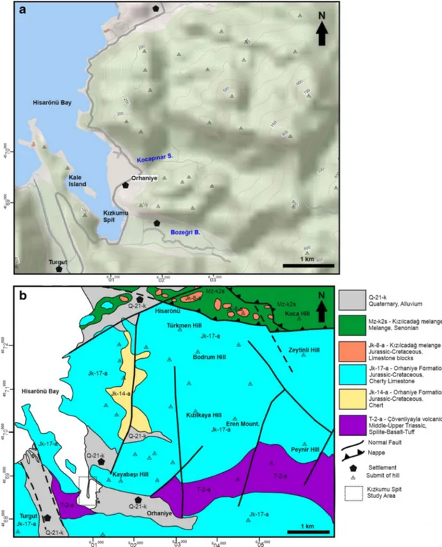
The study area is located in the southwest of Turkey. The oral communication with the local people and the previous studies emphasize that the spit area was above the sea level (Fig2b); however, the recent topographical maps encounter the spit below the sea level (Fig.2a).
Recent Google Earth images were studied in detail to un-derstand the possible sediment transportation ways and the coastal variations. These images were also taken into consid-eration to determine the possible structural units that may actively affect the formation of spit (Google Earth2017).
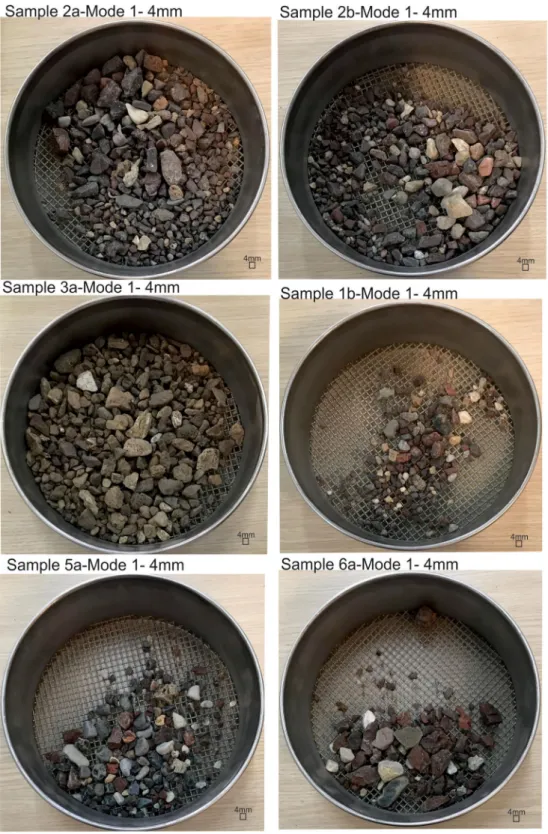
For the present study, twelve loose samples of both coarse-and fine-grained sediments were collected from six different locations during the field studies in order to determine the sed-iment type and grain size variations (Fig.3a, b). After surveying the whole Kızkumu Spit, sample 2 was taken from the closest point to the mainland (Fig3b). Samples 1, 4, 5 and 6 were taken from the northern feeding area—delta and the coast of the Kocapınar Stream (Figs.4and5a, b, c). Sample 3 was taken from the eastern feeding area—delta and the coast of the Bozeğri Stream (Figs.3aand 4). Sieve analyses of 6 samples (115–1905 g) were performed by using the standard sieves (31.5 mm–16 mm–4 mm–2 mm–1 mm–500 μm–250 μm– 125 μm–62 μm-pan; Figs. 6 and 7). The frequency ratios (Fig.6a), cumulative retained percentages (Fig.6b) and the cumulative passing percentages (Fig.6c), classification of sed-iments and their statistical evaluations (including sorting, mode, skewness, kurtosis) were made according to Folk (1974) and presented in Table1. The compositional variations of the sed-iments were evaluated according to the mode values under microscope to define the grains and their provenances (Fig.8).
Geology and Geomorphology of the K
ızkumu
and Its Surrounding
The Kızkumu and its surrounding region contain the Lycian Nappe Units and its Quaternary cover (Şenel and Bilgin 1997). The oldest geologic unit is the Çövenliyayla volcanics
composed of green-red spilite, basalt, green tuff, tuffite, local-ly radiolarite, chert and limestones (Middle-Upper Triassic; T-2-a; Fig.2b). The Orhaniye Formation contains the Jurassic-Cretaceous grey-beige-cream-yellow-pink-red-coloured micrite and chert with calciturbidites (Jk-17-a). Bedded cherty member (Jk-14-a) forms the upper part of the Orhaniye Formation, including thin-medium bedded red, reddish brown, locally grey-green-blue-coloured radiolarite, chert and shale (Fig.2b; Şenel and Bilgin1997). The Kızılcadağ melange contains the Cretaceous harzburgite, dunite, serpentinite, serpentinized harzburgite, dunite (Mz-k2s;
Upper Senonian) in matrix and olistostrome including the Jurassic-Cretaceous cherty limestone (Jk-8-a) blocks (Fig. 2b). These older units were uncomfortably overlain by the Quaternary alluvium (Q-21-k).
The distribution of these geological units may be responsible for the recent morphology of the Orhaniye-Hisarönü District and the bottom configuration of the marine environment. The valley of the Kocapınar Stream is surrounded by the hill with a maximum height of 800 m. Northern part of the valley includes the higher hills and ridges. Their heights are decreasing towards the sea down to the west. The stream ends with nearly flat Fig. 1 a The location of the Kızkumu Spit in SW Turkey. b The location of the spit area and the protected zone of the Hisarönü Bay (maps obtained from
topography of the Kocapınar delta. The Bozeğri Brook is locat-ed in the south eastern side of the study area. The valley of this brook is surrounded by the hill of maximum 600-m height, which decreases towards the west. The Bozeğri Brook valley is filled with an elongated delta. The weathered fragments from Çövenliyayla volcanic units and Orhaniye Formation have been transported initially to the valleys of the Kocapınar Stream and
Bozeğri Brooks. Afterwards, these sediments have been carried to the delta and the coastal areas (Fig.2).
Fig. 3 a The Google Earth image showing the sampling locations in the vicinity of the Kızkumu Spit. b The Google Earth image of the Kızkumu Spit with white arrow showing the red-coloured sediment movement boundary (Google Earth2017)
Fig. 2 a Topographical view of the Kızkumu Spit area (map obtained from thehttp://yerbilimleri.mta.gov.tr/anasayfa.aspx; access date: 09.01.2020). b Geological map of the study area (modified fromŞenel and Bilgin1997;http://yerbilimleri.mta.gov.tr/anasayfa.aspx;access date: 09.01.2020)
Characteristics of the K
ızkumu Spit
Ancient History
The Bybassos (B.C. 7th–6th century) ancient city located in and around the Kızkumu Spit includes ruins of the Early
Morphology
The measurements on the Google Earth image show that the Kızkumu spit has a slightly curved structure, 400 m length. The red-coloured sediment distribution at the open sea end is 18 m wide and the attached landside is 47–48 m wide (Fig. 3a, b). While Atabey (2002) states that the Kızkumu spit is
Fig. 4 The Google Earth image of the east of the Kızkumu Spit with white arrow showing the red-coloured sediment distribution from Bozeğri Stream (Google Earth2017)
Fig. 5 The Google Earth images of a the north of the Kızkumu Spit and the coastal side of the Kocapınar Delta. b The locations of the Samples 4 and 5 (dashed line shows the red-coloured mobile sediment boundary;
green arrows point out the coastal erosion due to breakwaters. c the location of Samples 6 (dashed line shows the red-coloured mobile sedi-ment boundary) (Google Earth2017)
Hellenistic and Byzantium church, farm, agricultural terrace, settlements, temple, port, wall, ceramics and amphora (Held et al.2007,2009,2011). The Kızkumu Spit has an old story linked with the Bybassos ancient city. Long time ago, the King of Bybassos lived with his beautiful daughter on the shores of today’s Orhaniye Village. The princess fell in love with a poor fisherman. Every night, these secret lovers com-municating with the lights of their lanterns. When the King learnt about this love, the king sent his soldiers to capture the fisherman. During the ambush, Princess rushed towards the sea. The sand poured from her skirt created a long narrow road for her; however, before reaching to the fisherman, she was hit by the arrow. Her blood gave the red colour to the sand. The poor fisherman took the princess to the boat and was lost in the sea. According to some others, the Bybassos was invaded by pirates and the king was killed. One night, when she was escaping with sand filled skirt, in each step she, sprinkled with a bunch of sand to the sea. The sand was accumulated on the floor where she walked through and elongated like a road. However, when the sand was all gone, she got drowned (http://www.routemarmaris.com/mobil/MShowDetail.aspx? MenuId=2898; http://www.muglakulturturizm.gov.tr/TR-158180/orhaniye%2D%2Dkizkumu.html access date 30.04. 2019).
375 m long and 5–15 m wide and 20–50 cm below the water, Ekinci and Doğaner (2016) indicates that the Kızkumu Spit is 10–30 m wide and 420 m long. Short-term variations of the wind and wave directions (mainly NW to SE) result in curved or hook morphology of the spit (Ekinci and Doğaner2016). Seawater depth is 7.5 m at the end of the open sea side and it is 2.5 m in the lagoon between the spit and Bozeğri Brook mouth (Atabey2002). Lagoon includes silt- and clay-sized sediments at the bottom and is covered by reed towards the Bozeğri Stream mouth. The stream mouth also contains small sand islands (Atabey2002). In addition, salt marsh and estuary were defined at the Bozeğri Stream mouth (Ekinci and Doğaner2016). Sea is deepening towards the Kale Island (western offshore of the spit) from 13 to 20 m (Atabey 2002). Ekinci and Doğaner (2016) identified that the bathym-etry of the Kızkumu Spit is up to 5 m in the offshore side of the Kocapınar Delta. Wavelengths in the study area were deter-mined as 1.25 m (Ekinci and Doğaner2016). Those WNW- to ESE-directed waves led to the formation NW- to SE-directed longshore currents. Changing of wave refraction and the in-terruption of the longshore currents due to coastal structures (breakwater etc.) cause the coastal erosion and newly formed small sediment accumulations in the Kocapınar Stream Delta.
Sediment, Deposition and Feeder System
Samples 2a and 2b, obtained from the Kızkumu, are poorly sorted, platykurtic, sandy gravel (Table1). Average grain size of the Sample 2a is (− 1.6 Ø) and Sample 2b is (− 1.6 Ø) (Fig. 6d; Table1). Both samples have Mode 1 in− 2.0 Ø (4 mm), Sample 2a also has second mode value Mode 2 (− 2.0) Ø (1 mm) (Fig.6e; Table1). Sample 3 (from the Bozeğri Brook), classified as sandy gravel, while average grain size of it is smaller than the Kızkumu samples 2a and 2b. Sample 1 (sandy gravel) grain size is smaller than the Kızkumu samples (from southern part of the Kocapınar Stream Delta). Samples 4 and 5 (from central part of the Kocapınar Stream Delta) generally include gravelly slightly gravelly sand, and Sample 6 (from northern part of the Kocapınar Stream Delta) is classified as sandy gravel (Table1).
Figures7and8present detailed views of the coarse- and fine-grained mode values, respectively. Coarse-grained mode section of Sample 2 mainly contains black-coloured volcanic rock fragments, reddish brown-coloured chert and, to a lesser extent, white-coloured limestone fragment-bearing gravels. Sample 3 from east of the Kızkumu spit also has a similar composition; however, the limestone fragments are in rela-tively low ratio. Samples 1, 5 and 6 from north of the Kızkumu spit have higher ratios of limestone fragments (Fig.7).
Finer-grained mode section of Sample 2 contains red-coloured radiolarite, black-brown-green-red-coloured volcanic rock fragments and red-white-coloured limestone fragment–
bearing sands. Sample 3 contains generally dark-coloured (black-green) volcanic rock fragment–bearing sands. However, Samples 1, 4, 5 and 6 contain mostly red-coloured sediments including chert, radiolarite and limestone fragment–bearing sands (Fig.8).
Considering the type of sediment and related grain size of the Kızkumu Spit, source sediments of the spit must be transported from both Delta of the Kocapınar Streams and Bozeğri Brook. Coarse-grained volcanic rock gravels of the spit were transported from the eastern side, while limestone gravels mostly were transported from the northern part. Fine-grained volcanic sands can be transported more or less from both sources, while limestone sands were mostly transported from the northern part.
Similarly, Atabey (2002) and Ekinci and Doğaner (2016) reported that the Kızkumu Spit contains radiolarite, chert, limestone fragments bearing angular-subrounded, brown, yel-low, red gravels and sands. Atabey (2002) also suggested that these sediments derived from the Bozeğri Stream, which could be dispersed to 250 m towards the open sea, and after, NW to SE oriented sea waves carry the sediments to the SE and lead to the formation of the Kızkumu. However, Ekinci and Doğaner (2016) proposed that the sediments of the Kocapınar Stream Delta are carried by the longshore currents: wind and wave actions from NW to SE lead to formation of the Kızkumu Spit. Moreover, Ekinci and Doğaner (2016) stat-ed that the Kocapınar Stream reaches to maximum discharge during the rainy spring season; therefore, wave actions and sediment transportations due to decreasing of the capacity of longshore currents were the least intense during this period limiting the development of the spit.
Discussion
The results of the sieve and images analyses point out that the Kızkumu Spit has been fed from both north and east direc-tions. Dark-coloured volcanic rock fragments are mainly de-rived from the eastern Bozeğri Brook, while white-red-coloured limestone and red-white-red-coloured chert fragments are mainly derived from the northern Kocapınar Stream Delta (Figs.7and8). However, the Kızkumu Spit sample (Sample 2) has relatively more gravel-sized sediments. Only a few samples (Sample 6B and Sample 3B) have gravel ratio values similar to Kızkumu Spit. Relatively low ratio of gravel-sized sediments may be because of sampling and/or decreasing of wave and longshore current effects to the spit. Additionally, finer-grained sediments may be winnowed by the waves and/ or initially dispersed due to tourism activities and later winnowed, which at the end causes the dominancy of the coarser sediments of the Kızkumu Spit.
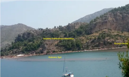
The general view of the Kızkumu Spit shows that the spit is covered by marine water (Fig. 9). However, several sources
Fig. 7 Macro-views of the selected samples in a grain size of 4 mm
mentioned that this region was mapped above sea level in 1/ 25000 scaled topographical maps of 1963 and 1/25000 scaled
topographical map printed in 1996 by General Commander of Mapping: beach in geological map (Fig.2b;Şenel and Bilgin 1997). Local residents also reported that the Kızkumu Spit was above the sea level during the 1980s. They also men-tioned that the significant quantity of the sediment was used for the construction purposes. Sand extraction drawing from the delta and the coast for the construction affected the
Fig. 6 Graphics showing the a frequency curves of the samples based on the results of the sieve analysis. b Cumulative weight retaining percentage (%) versus grain size (Ø). c Cumulative weight passing percentage (%) versus Grain size (mm). d Average grain size (Ø) versus Sample no. e Sorting (Ø) versus Sample no.Table 1 S tat isti cal pa ra me ter s of the sieve an al ysis, and th e classification of the se di ments according to F o lk ( 1974 ) Sta tis tic al par amet ers Gr ain si ze p er ce ntag e (%) Samp le no Median (ɸ ) A verage grain size (ɸ ) S orting (ɸ )S k ew n es s (ɸ )K u rt o si s (ɸ ) M ode 1 M ode 2 C G M G F G G r V CS CS MS FS VFS G ravel S and M ud Folk ( 1974 )c la ss 1a − 0.4 − 0.5 1 .7 P S − 0.10 NS 0.9 6 MK 0.0 0 .7 9.3 8 .9 18.9 2 2.1 19.2 16.5 3 .6 0.5 37.8 61.9 0.3 sG 1b − 0.2 − 0.4 1 .8 P S − 0.14 NS 0.9 2 MK − 2.0 1 .0 0.0 10.0 8 .6 17.4 1 8.3 20.3 18.8 5 .3 0.9 36.1 63.6 0.4 sG 2a − 1.3 − 1.6 1 .3 P S − 0.40 S C S 0 .6 8 P K − 2.0 0 .0 3.6 16.4 18.4 25.6 2 5.2 10.0 0 .6 0.0 0 .0 64.1 35.9 0.0 sG 2b − 2 − 2.0 1 .2 P S 0 .04 NS 0.8 4 P K − 2.0 0 .0 24.0 25.8 27.4 1 9.0 3 .6 0.1 0 .0 0.0 77.2 22.8 0.0 sG 3a − 1 − 1.0 2 .1 V P S 0 .08 N S 0 .8 9 P K − 2.0 0 .0 3.8 14.2 15.3 16.4 1 6.6 14.5 9 .5 5.7 3 .5 49.7 49.9 0.4 sG 3b − 1.8 − 1.3 2 .1 VPS 0 .33 S FS 0.7 8 P K − 2.0 0 .0 10.8 19.2 17.9 12.8 1 1.9 10.2 7 .3 4.3 3 .0 60.7 36.7 2.6 sG 4a 0.5 0 .4 0.9 M oS -0.0 2 N S 1 .6 9 V LK 1.0 0 .0 1.0 2 .1 1.2 1 4.9 58.5 14.4 7 .0 0.7 4.3 95.6 0.1 (g)S 4b 0.6 0 .6 0.8 M oS 0 .13 F S 1.3 8 LK 1.0 0 .0 0.0 0 .8 0.6 1 0.4 61.7 16.9 8 .7 0.8 1.4 98.5 0.1 (g)S 5a 0.7 0 .7 1.3 P S − 0.25 C S 1.5 8 VLK − 2.0 1 .0 1.1 3 .9 5.7 2 .1 9 .4 42.5 27.7 7 .0 0.4 12.8 87.1 0.1 gS 5b 0.6 0 .6 1.2 P S − 0.21 C S 1.7 4 VLK − 2.0 1 .0 0.0 5 .0 5.6 1 .9 8 .3 49.7 23.9 5 .4 0.2 12.5 87.5 0.0 gS 6a − 0.2 − 0.8 2 .2 VPS − 0.34 S C S 0 .6 6 V PK − 2.0 2 .0 10.6 11.4 11.7 9 .0 9 .8 17.5 26.9 2 .9 0.2 42.7 57.3 0.0 sG 6b − 3 − 2.2 2 .4 VPS 0 .44 S FS 0.5 8 VPK − 4.0 2 .0 36.4 11.6 12.1 5 .8 6 .4 10.8 14.8 2 .0 0.1 66.0 34.0 0.0 sG Sorting: VP S very poorly sorted, PS poorly sorted, MoS moderately sorted, WS we ll so rte d , VWS ve ry well sorted. S ke wne ss: SFS st rongly fine skewed, FS fi ne skew ed , S symmetr ic , CS coar se skew ed, SCS ver y co ar se sk ewe d .K ur tosis : VP K very platykurtic, PK platykurtic, MK mesokurtic, LK leptokurtic, VL K very leptokurtic. CG coar se gra v el ,MG medium gravel, FG fine gravel, Gr granule, VCS very co ars e sand, MS medium sand, VF S very fine sand, sG : sandy g ravel, gS gravelly sand; (g)S slightly g ravelly sand; FSk fi ne ske w ed; CSk co ars e skew ed
Fig. 8 Micro-views of the selected samples in a grain size 1 mm sediment input to the spit (Ekinci and Doğaner2016). A range of 20-–50-cm seawater cover on the spit due to spreading sediments by touristic walking especially during the summer time was reported by Atabey (2002). The local divers stated that 50 cm–1 m below the sea surface, thick unconsolidated sediments and rocky (possibly older rocks of limestone and volcanics) surface were detected. The limited sediment accu-mulation may develop due to structural distribution of the rocky surface at the base. This thin sediment accumulation of the Kızkumu Spit requires very urgent protective measures. Google Earth image shows that there is no sediment activ-ity through the Kocapınar Stream Delta to prevent longshore currents after the marina construction (Fig.5). In addition, small docks or breakwaters (at least five) prevent the sediment movement. Depending on the change in the wave direction, southern parts of the breakwaters are under the effects of the
coastal erosion; northern parts act as sediment accumulation area. Dashed line of the red-coloured mobile sediment bound-ary is observed very close to breakwater; therefore, sediment input to the Kızkumu Spit has probably been cut via breakwa-ters (Fig.5b).
Ekinci and Doğaner (2016) defined that the marina (Fig. 5c) and docks create important obstacles for the longshore currents and sediment transportation to the spit. It is also suggested by the same studies that the destruction of Poseidon type seaweed and marina on the sediment transportation way create pressure on spit development. Kumara et al. (2010) also pointed the importance of the sed-iment source land–based factors for spit development.
Anthropogenic activities including construction (piers-ma-rina-breakwater, hotel), tourism activities (boat, walking etc.) together with the longshore currents and the sediment input
Fig. 9 Photograph showing the general view of the Kızkumu Spit, Jurassic-Cretaceous limestone and Bozeğri Brook
control the evolution of the Kızkumu Spit. Ekinci and Doğaner (2016) and Atabey (2002) offered some preservation methods including new tourism activities, limiting the number of visitors and coastal construction. However, additional pre-cautions must be taken into consideration along the longshore current and also drainage area of the Kocapınar and Bozeğri Streams. The coast and the drainage area that hinder the sed-iment transportation must be prevented. Sustainability of the sediment supply from both directions has vital importance for the long duration of the Kızkumu spit. Possible sea level rises due to global warming (IPCC2014) may also threaten this region. Additional sea level risings increase the water body thickness on the spit, hence the spit may totally be under water. Therefore, the areal distribution of the Kızkumu Spit, especially the sediment dispersal, must be monitored; if nec-essary, sand dispersion preventive methods (fence, net etc.) should be applied.
SW Anatolia mainly includes rocky coasts due to the tec-tonic development and the lithology of the host rock (e.g. Gül et al.2017,2019b). Western part of Turkey hosts some im-portant spit evolutions such as in Çanakkale (Kazancı2013), Büyük Menderes River Mouth (Erol1996,1997), Ölüdeniz, Dalaman, Güllük, Sasalı, Aliağa and Dikili determined from Google Earth images. Two spits have been well documented in Muğla coast: the İztuzu Spit (Maktav et al.1996; Brückner 1997; Gül et al. 2019a) and Kızkumu Spit (Atabey 2002; Ekinci and Doğaner2016). Special environmental conditions including river mouth, sediment input, wave-wind directions and long shore currents were all responsible for their forma-tion (Maktav et al.1996; Brückner1997; Atabey2002; Ekinci and Doğaner2016; Gül et al.2019a). Main beach of theİztuzu Spit is around 56 ha, and mainly includes well-sorted sand size sediments with benthic foraminifera and ostracod fossil shell on the surface (Maktav et al.1996; Gül et al.2019a). The
open edge of İztuzu Spit is limited by the Dalyan River Mouth, and this spit also acts as a breeding area for the loggerehead-Caretta caretta turtle (Maktav et al. 1996). Moreover, the İztuzu Spit has been affected by the human interactions due to improper pier constructions (Gül et al. 2019a). The Kızkumu Spit only covers 0.92 ha, and mainly includes coarser gravel–sized sediments, and open edge lim-ited by the sea. The historical relation of the Kızkumu spit is increasing the attraction of the region. The direct human im-pact on the Kızkumu Spit is stronger than the İztuzu Spit. In addition, location of the Kızkumu Spit may have been con-trolled by the bottom topography, and its evolution requires more specific combination of wave-wind action, sediment in-put and longshore current.
Spit areas are among the most spectacular landscapes around the world (Povilanskas et al.2016) with unique mor-phologies and complex evolution patterns. These unique land-forms are very sensitive to the environmental conditions; therefore, any change in the natural processes as well as the human interventions could possibly deteriorate this delicate environment. If the landform is very restricted in a narrow zone like the Kızkumu Spit, it is inevitable to lose it forever.
Conclusion
The Kızkumu Spit is one of the unique spits of SW Turkey with its attractive historical story and environmental beauty. This small spit is only 400 m long and 18–48 wide.
& The Kızkumu Spit has been formed by the two river sed-iments transported by the longshore currents. In addition, bottom topography, wave and wind actions control the spit formation.
& Furthermore, large (marina) and small (breakwater) coast-al structures prevent the excess wave effects and change the direction of waves and longshore currents. Thus, dis-integration of the deltaic sediments is decreasing. Small-scaled coastal erosions were also detected in one side of these structures, while the sediments were entrapped on the other side of the spit. Therefore, the amount of the sediments flowing towards the Kızkumu is reduced. & Excess tourism activities (including walking on the spit,
marine vehicle usages) cause the dispersion of sediment on the Kızkumu Spit. The marine water depth (recently varies between 20 and 50 cm) on the spit is increasing; therefore, wave action is enhancing. This situation leads winnowing of the fine-grained sediments and accumula-tion of much coarser sediments on the spit. These inter-supporting processes accelerate inevitable adverse effects on the evolution of the spit.
& If the conservation pathway is not drawn soon, this unique geological formation could be irreversibly damaged and the spit formation might be totally lost. Extinction of such a peculiar geoheritage may threaten the local summer tour-ism and the socio-economical life of the region.
Acknowledgements The authors of this manuscript would like to thank the anonymous reviewers for their invaluable comments which signifi-cantly improved the quality of the paper. The editorial handling of Dr. Kevin PAGE and the editorial office of the Geoheritage contributions are highly acknowledged.
References
Alexandrakis G, Poulos S, Petrakis S, Collins M (2010) The development of a Beach Vulnerability Index (BVI) for the assessment of erosion in the case of the North Cretan Coast (Aegean Sea). Hell J Geosci 45:11–22
Alexandrakis G, Manasakis C, Kampanis NA (2015) Valuating the ef-fects of beach erosion to tourism revenue. A management perspec-tive. Ocean Coast Manag 111:1–11
Atabey E (2002) Korumaya Değer Doğal Bir Kum Dili, Orhaniye Kızkumu (A Natural Sand Tongue, Orhaniye Kızkumu). Mavi Gezegen 6:76–77 (in Turkish)
Bird E (2008) Coastal Geomorphology an Introduction. John Wiley, Sons Ltd, Chichester, p 436
Brückner H (1997) Coastal changes in western Turkey; rapid delta progradation in historical times. Bulletin de l’Institut oceanographique, Monaco, no special 18. CIESM Sci 3:63–74 Dan S, Walstra DJR, Stive MJF, Panin N (2011) Processes controlling the
development of a river mouth spit. Mar Geol 280:116–129 Danladi IB, Kore BM, Gül M (2017) Vulnerability of the Nigerian coast:
an insight into sea level rise owing to climate change and anthropo-genic activities. J Afr Earth Sci 134:493–503
Ekinci D, Doğaner MS (2016) Unique Spit: KızKumu (Marmaris/ TURKEY). EPRA Int Journal of Multidiscip Res (IJRM) 2(6):35– 49
Erol O (1996) Türkiye’deki kıyı kullanım sorunlarına jeomorfolojik yaklaşımlar (Geomorphological approaches to coastal use issues in Turkish coast). Türkiye Coğrafyası Araştırma ve Uygulama Merkezi (Turkey Geography Research and Application Centre),
III. Coğrafya Sempozyumu Bildiri Özetleri (3rd Geography Symposium Abstracts), Ankara, p. 12 (in Turkish)
Erol O (1997) Türkiye’deki kıyı kullanım sorunlarına jeomorfolojik yaklaşım (Geomorphological approaches to coastal use issues in Turkish coast). Türkiye Coğrafyası Araştırma ve Uygulama Merkezi (Turkey Geography Research and Application Centre). Türkiye Coğrafyası Dergisi (J Geogr Turk) 6:93–122 (in Turkish) Folk RL (1974) The petrology of sedimentary rocks. Hemphill
Publishing Co., Austin, p 182
Google Earth (2017). SW Turkey. 36° 45’24.55”K 28°07’04.60”D. Eye alt 4.21 km. Image CNES/Airbus 2018.
Gül M, Danladi IB, Kore BM (2017) Coastal types of graben: the Gulf of Gökova, Mugla-SW Turkey. J Coast Conserv 21(1):127–138 Gül M, Salihoğlu R, Dinçer F, Darbaş G (2019a) Coastal Geology of
Iztuzu Spit (Dalyan, Muğla, SW Turkey). J Afr Earth Sci 151: 173–183.https://doi.org/10.1016/j.jafrearsci.2018.12.017
Gül M, Yılmaz Ö, Zeybek Ö (2019b) Morphology and textural charac-teristics of coastal sediments of the NE of the Gökova Graben (SW Turkey). J Coast Conserv 23:417–434.https://doi.org/10.1007/ s11852-018-0672-3
Held W,Şenol GC, Şenol AK (2007) 2005 Yılı Bybassos Araştırması (2005 Bybassos Survey). 26. Araştırma Sonuçları Toplantısı (26th Research Results Meeting), Turkish Republic, Culture and Tourism Ministry 37–50
Held W,Şenol GC, Şenol AK (2009) 2008 Yılı Bybassos Araştırması (2008 Bybassos Survey). 27. Araştırma Sonuçları Toplantısı (27th Research Results Meeting), Turkish Republic, Culture and Tourism Ministry, 3rd volume 215–232
Held W,Şenol GC, Şenol AK (2011) 2009 Yılı Bybassos Araştırması (2009 Bybassos Survey). 28. Araştırma Sonuçları Toplantısı (28th Research Results Meeting), Turkish Republic, Culture and Tourism Ministry, 3rd volume, 325–340
IPCC (2014) In: Pachauri RK, Meyer LA (eds) Climate Change 2014: synthesis report. Contribution of Working Groups I, II and III to the Fifth Assessment Report of the Intergovernmental Panel on Climate Change, Core Writing Team. IPCC, Geneva, p 151
Jarmalavičius D, Satkunas J, Zilinskas G, Pupienis D (2012) Dynamics of beaches of the Lithuanian coast (the Baltic Sea) for the period 1993– 2008 based on morphometric indicators. Environ Earth Sci 65(6): 1727–1736
Kazancı N (2010) Jeolojik Koruma; Kavram ve Terimler (Geologic pres-ervation: concept and terms). Jeolojik Mirası Koruma Derneği yayını (publication of Association of geological heritage protection of Turkey), Ankara, p. 60 (in Turkish)
Kazancı N (2013) Çardak Kıyı Dilinin Jeolojisi (Lapseki, Çanakkale) (Geology of Çardak Spit). In: Öner E (ed) Memorandum toİlhan Kayan. Aegean University, Literature Faculty Publication, pp 225– 245 (in Turkish)
Kumara A, Narayana AC, Jayappa KS (2010) Shoreline changes and morphology of spits along southern Karnataka, west coast of India: a remote sensing and statistics based approach. Geomorphology 120:133–152
Maktav D, Sunar F, Kapdaşlı S, Musaoğlu N (1996) Remote sensing application in a specially protected area (small paradise) in Turkey. Int Arch Photogramm Remote Sens Vienna 31:465–468 Monge-Ganuzas M, Evans G, Cearreta A (2015) Sand-spit accumulations
at the mouths of the eastern Cantabrian estuaries: the example of the Oka estuary (Urdaibai Biosphere Reserve). Quat Int 364:206–216 Nagarajan R, Jonathan MP, Roy PD, Muthusankar G, Lakshumanan C
(2015) Decadal evolution of a spit in the Baram river mouth in eastern Malaysia. Cont Shelf Res 105:18–25
Oertel GF (1985) The barrier island system. Mar Geol 63:1–18 Ollerhead J, Davidson-Arnott RGD (1995) The evolution of Buctouche
Spit, New Brunswick, Canada. Mar Geol 124:215–236
Otvos EG (2012) Review Coastal Barriers Nomenclature, processes, and classification issues. Geomorphology 139-140:39–52
Petrakis S, Alexandrakis G, Poulos S (2014) Recent and future trends of beach zone evolution in relation to its physical characteristics: the case of the Almiros Bay (Island of Crete, South Aegean Sea). Glob NEST J 16(1):104–113
Povilanskas R, Baziuk D, Dučinskas K, Urbis A (2016) Can visitors visually distinguish successive coastal landscapes? A case study from the Curonian Spit (Lithuania). Ocean Coast Manag 119:109– 118
Şenel M, Bilgin ZR (1997) Marmaris–L6 Quadrangle, 1: 100.000 scale geological map and explanatory text. Mineral Research and Exploration Institute of Turkey (MTA) Publications 9 p (unpub-lished, in Turkish).
Stanica A, Ungureanu VG (2010) Understanding coastal morphology and sedimentology. NEAR Curriculum in Natural Environmental Science, Terre et Environment 88:105–111
Thomas T, Lynch SK, Phillips MR, Williams AT (2014) Long-term evolution of a sand spit, physical forcing and links to coastal flooding. Appl Geogr 553:187–201
Van Der Weide J, De Veroeg H, Sanyang F (2001) Guidelines for coastal erosion management. In: Özhan E (ed) Proc. of the Fifth International Conference on the Mediterranean Coastal Environment, MEDCOAST 01, MEDCOAST Secretariat, vol 3. Middle East Technical University, Ankara, pp 1399–1414 Wimbledon WAP (1996) National site election, a stop on the road to a
European Geosite List. Geol Balc 26:15–27
Woodroffe CD (2002) Coasts: form, process and evolution. Cambridge University Press, Cambridge, p 638