ABSTRACT This study aims to develop a better understanding of diffusion of Geographic Information Systems within municipalities and examines the infrastructure of İstanbul municipalities and whether they are ready for this technology or not. This study uses two research methods: The first one comprises interviews with the experts of GIS in Turkey. The second one comprises questionnaires conducted with Geographic Information Systems -related departments of İstanbul municipalities. Data collected online have been analyzed by using descriptive statistics, reliability tests, Anova and regression to test the hypotheses. One of the findings is that almost half of the municipalities implement Geographic Information Systems without a vision or a plan for the future. Another finding is that Geographic Information Systems is mainly used to perform registration and maintenance functions instead of supporting the decision-making process. Finally, there is an optimistic expectation of municipalities regarding the use of Geographic Information Systems in the future.
1 INTRODUCTION AND OUTLINE OF RESEARCH
Using information technologies (IT) and information systems (IS) is a very common and compulsory issue in all sectors nowadays. Since geographic information system (GIS) is a kind of information technology which enables us visualize, question, analyze, interpret, and understand data in many ways that reveal relationships, patterns, and trends in the form of maps, globes, reports, and charts, it is being used inevitably by all sectors. Municipalities are one of the governmental organizations which use GIS mostly to collect, store, use and evaluate data related to geography.
Due to the reasons mentioned above, municipalities need a new tool or a technology to deal with those data in order to increase their efficiency. The only tool and technology to meet their requirements is GIS tool. Using such tools and techniques, municipalities reduce their work load and time spent. Also, they provide better services and make more profits. On the other hand, they have to share data and information with other governmental organizations and citizens. Therefore, they have to obey some rules and regulations enforced by the governmental organizations to bring standardization and to have high quality data and information. Also, to be more competitive, they serve those data to their citizens and in this way, they provide better services to their citizens. Because of those
Diffusion of Geograpgic Information System at Municipalities in
Istanbul
M. Çavur
Boğaziçi University, Management Information System, İstanbul
M. Özturan
Boğaziçi University, Management Information System, İstanbul
C. Karaduman
Boğaziçi University, Management Information System, İstanbul
A.B. İçli
regulations, social requirements and special reasons, not only municipalities but also all governmental organizations, which are dealing with spatial data and information, have to use GIS technologies.
The objectives of the study are to understand the diffusion of GIS at municipalities in İstanbul, to determine failure and success factors during implementation, to find out required infrastructure for a successful GIS implementation, to understand the problems related with GIS diffusion and finally to figure out the future expectations of İstanbul municipalities from GIS.
In the literature there are many studies about “Implementation of GIS in a Municipality” in Europe, Canada, Australia and USA, but there are only a few studies about that topic in Turkey. For this purpose, interviews with experts and surveys with municipalities were conducted to study about “The Diffusion of GIS at Municipalities in İstanbul”. The interviews were held with three different groups which are academicians, employees in private sector and IT/IS managers in municipalities. The questionnaire was held online with the Metropolitan Municipality of İstanbul and 39 İstanbul districts and the data collected were analyzed through various statistical methods using SPSS 15.
2 BACKGROUND
In this section, data, information, knowledge and GIS terms are discussed in order to have a clear understanding of the study.
2.1 Data, Information and Knowledge Data is converted into information after processing. According to Hicks (1993), information is a processed version of data which is meaningful to a decision maker. Data are meaningless without processing and interpretation. Therefore, it should be
converted into a new form that is easier to be understood by the users. In this way, the user can understand and use information for their purposes and make decisions with respect to this information. Evaluating data provides a healthier decision for the decision-maker.
Longley et al. (2001) assert that information is distinct from data in terms of selection, organization and preparation for a specific purpose. Information serves some ideas which means an interpreted version of data. As can be seen from the definitions, it is clear that the words data and information have different meanings. The relation between reality, data, information and knowledge is complex (Figure 1).
Fig 1. The relation between data, information, and knowledge. (Carrera, 2004)
2.2 Geographic Information System (GIS) Since GIS is an interdisciplinary method of solution for different areas, there are varying types of GIS definitions with respect to different perspectives. Each profession uses a specific part of GIS extensions or modules; therefore they have different definitions for GIS.
De Man (1988) and Carter (1989) affirm that GIS are perceived as distinctive instances of information system. This is the purest definition of GIS. Indeed, it is clear that information is very important for GIS.
GIS mainly consists of two different types of data which are called spatial (geographical) and non-spatial (non-geographical), and has a relational database between these two types of data and has been accepted as a remarkable information system tool.
Dangermond (1988) maintains that GIS comprise five rudimentary parts: data, hardware, software, procedure and people. One wants to use technologies mainly to benefit from them. Indeed, using GIS brings many advantages to governmental and private organizations. Time, efficiency and money are the main advantages of GIS for organizations. Carter (1989) stresses that implementation of GIS requires an organizational structure which combines technology, database, expertise and ongoing financial support. It is for certain that GIS will also bring some financial advantages in time for the organizations using GIS.
3 LITERATURE SURVEY
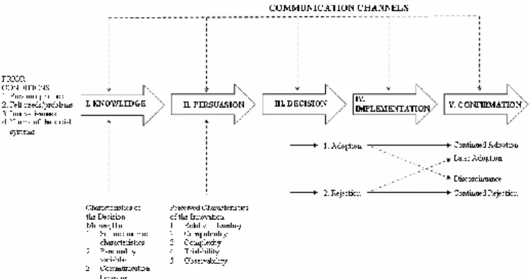
In the diffusion cycle, the technology is to be accepted and implementation phase is to be achieved following the satisfaction of the citizens or end users. Investing more money, time and people for a new technology brings about more success and implementation evolves into to adoption. Last stage is to develop and invest some more money for a new technology. It means that the new technology is the part of that governmental organization which has to use this technology. After this stage, the new technology not only provides intangible satisfaction for management, end users and citizens; but also provides some tangible benefits. The resources can be used more efficiently and costs of services to the organization are reduced. In accordance with the ideas of Medlin (2001) and Parisot (1995), Rogers’ diffusion of innovations theory is the most suitable way of exploring the adoption of technology in higher education. There are five steps of diffusion of a new innovation (Figure 2).
Fig 2. A Model of five stages in the innovation-decision process (Rogers, 2003)
3.1 The Diffusion of GIS at Municipalities in Istanbul
Istanbul is the largest city in Turkey. According to the address-based birth recording system of the Turkish Statistical Institute, the population of the metropolitan municipality, which corresponds to 17.98% of Turkey's population, is 13.26 million as of 2010 and this places Istanbul as the third largest city in Europe after Moscow and London. Since it is the largest and the most crowded city , management of Istanbul is a difficult task. For this reason, it had been divided into different districts throughout history. 8,156,696 people live in the European side and 4,416,867 people live in the Asian side. According to Istanbul Nufus ve Demografik Yapi [Population and Demographic Structure of Istanbul] (n.d.), there are 25 municipalities on the European side and 14 municipalities are on the Asian side.
Municipalities are the representatives of government which encounter with citizens mostly. Their main purpose is to provide better services to citizens pertaining to fresh water, electricity, real estate, tax, natural gases, sewage and more. The complexity of tasks, such as distribution and control of power, fresh water and natural gas, sewage, telephone, school and hospital networks, has been forcing municipalities to find a way to
organize these tasks. Besides, some problems about these tasks that are mentioned above occur. For instance, traffic accidents, natural hazards and fire incidents all force the municipalities to come up with fastest and the most efficient solution. In order to organize these tasks and overcome related problems, appropriate tools and techniques are needed. At this point, GIS is accepted as one of the best solutions for municipalities nowadays.
The awareness for this technology began at the beginning of 1990s; however, it was started to be used at the beginning of 2000s. Municipalities of bigger cities’ with respect to their populations, such as Ankara, Bursa, Istanbul, Izmir and Konya, started to exploit the advantage of this technology firstly. However, smaller municipalities have not used it effectively due to lack of awareness and budget. Yomralioglu (2002) says that only some municipalities, such as in Istanbul, Bursa, Ankara, Izmir, Aydin and Antalya, utilize GIS more realistically than the rest.
It is clear that only 4% municipalities attempt to exploit that technology effectively. Should a further research on exploitation of this technology conducted, the percentage will surely increase.
Yomralioglu (2002) challenges the key drives of municipalities, that is awareness of thematical, topographical and administrative structure of all provinces, and adds other motives such as accomplishing health, security, population, communication and road networks, etc. In addition, municipalities actively use GIS especially in solving important local problems such as urban planning, land development, urban management, supervision, and tax collection.
4 THEORITICAL MODEL AND HYPOTHESIS
4.1 Problem Statement
Today, almost all sectors are dealing with GIS technology in one way or another. When these sectors are divided into different parts with respect to their usage level, it is found out that governmental organizations use GIS technology more heavily than private sector. If a comparison is made among governmental organizations, it is seen that municipalities use GIS tools and software mostly with respect to others. Almost all departments use GIS technologies directly or the products of GIS technologies indirectly.
Although municipalities are governmental organizations, they are independent within their internal affairs and policies in Turkey. Therefore, they can easily accept and implement new systems or projects for their use and enjoy the advantages without dealing with too much bureaucracy. There is no competition among municipalities, so they can support each other with their experiences.
4.2 Aim and Objectives
The aim of this study is to explore the usage and diffusion level of GIS at municipalities in İstanbul and opinions of their employees about the following issues:
Development of GIS at municipalities in İstanbul
Research about GIS implementation at municipalities in İstanbul and Turkey
Failure and success factors during
implementation of GIS at municipalities in İstanbul based on literature survey, expert opinion and survey results
Type of infrastructure required for a successful GIS implementation at municipalities in İstanbul
Kind of problems that may occur during GIS implementation at municipalities in İstanbul
Anticipation of the future of GIS in the short term (5 years) and long term (10 years) at municipalities in İstanbul
4.3 Key Questions
Based on the objectives, the following research questions are prepared;
What are the main requirements to implement GIS at municipalities successfully?
What are the failure and success factors for municipalities during implementation of GIS?
What kind of purposes are there for using GIS at municipalities?
What kind of problems may occur during implementation of GIS projects at
municipalities?
Through which processes is GIS
implemented at municipalities in İstanbul?
What are the driving forces for GIS implementation in a municipality?
What are the strategies that municipalities apply during the implementation process of GIS?
Who are the actors and what are their roles during implementation of GIS?
What does GIS bring to a municipality?
What is the future of GIS at municipalities in İstanbul?
4.4 Hypothesis
Based on the aim and objectives, the following hypotheses are determined (Table 1). Each hypothesis is analyzed with different test.
Table 1. Hypotheses about Diffusion of GIS at Municipalities
NO HYPOTHESES
H1 There is a relationship between the level of knowledge about GIS and geography- related areas with the success level of GIS diffusion.
H2 There is a relationship between the usage frequencies of GIS in municipalities’ departments with the success level of GIS diffusion.
H3 There is a relationship between the levels of acceptance of GIS projects with the success level of GIS diffusion. H4 There is a difference between municipalities with
different longitude of use of GIS in terms of the success of GIS diffusion.
H5 There is a difference between municipalities with different population groups in terms of the success of GIS diffusion.
H6 There is a difference between municipalities with different numbers of employee groups in GIS departments in terms of the success of GIS diffusion.
H7 There is a difference between municipalities with different number of employee groups in municipalities that use GIS tools in terms of the success of GIS diffusion. H8 There is a difference between municipalities with
different satisfaction levels of GIS applications in terms of the success of GIS diffusion.
5 RESEARCH METHODOLOGY
The methodology of this research consists of two important stages. The first stage comprises interviews with the experts of GIS. The second stage comprises a survey focusing on local municipalities of İstanbul 5.1 Interviews
Interviews, which were held with end users, consultants, technical users, developers and managers of municipalities responsible for GIS department or projects, were conducted using face-to-face method.
5.2 Questionnaire
The research was conducted during the spring semester of 2010-2011 by means of a questionnaire which had been developed based on previous researches and theories as well as interviews with GIS experts. Municipalities in İstanbul were decided to be of concern in this study because İstanbul is considered an important research area. Although many of the municipalities use GIS technologies, some municipalities have not used GIS technologies as of the publication date of this study. The questionnaire, which covers the GIS-related departments in municipalities, includes five sections and a
total of 36 questions. The questionnaire is distributed to the municipalities in İstanbul via Internet.
6 ANALYSIS AND FINDINGS 6.1 Interviews
In this part, summarized opinions of interviewees are reported under five main headings: overview of GIS, purpose and usage of GIS at municipalities in İstanbul, main problems related with GIS diffusion at municipalities in İstanbul, future of GIS for İstanbul municipalities, and criteria for a successful GIS implementation.
6.2 Purpose and Usage of GIS at Municipalities in Istanbul
The order of priority in using GIS, in order of first priority to last, is emergency issues such as people in a difficult conditions, fire, ambulance, etc. then citizens, and finally institutions. From parcel-sale and social aid to flooding and property analysis are for what GIS is utilized.
GIS is about spatial information but MIS is about human information. With the perfect integration of both, it provides services to citizens with maximum performance. For example, handicapped or educated citizens can easily be followed by the integration of MIS and GIS. In this way, more accurate decisions about them can be made.
The workload of employees of
municipalities in İstanbul has been decreased with the use of GIS. Therefore, this
convenience surely is reflected on the citizens. They are now enjoying faster services with higher quality. Since the number of complaints has been decreased, the management is satisfied with this new system.
GIS is used in every task including numbers, such as road and real estate
information. Briefly, it is used in everything that includes geography at municipalities in İstanbul.
The communication between external institutions and municipalities in İstanbul has increased; so the number of mistakes has decreased. For example, determination of the rate of incomplete declaration and defective buildings is now easier thanks to the usage of GIS at municipalities in İstanbul. In this system, the problems that used to be solved in 3-5 days are dealt with one click.
Since municipalities are not service-oriented organizations, they use CAD tools just to create maps. Therefore, they waste their time with these tools. Almost 90% of them use CAD tools instead of GIS tools.
All matters that require the use of spatial analysis are of interest, especially the control of numeric identification, creation of a new numeric identification numbers, problem identification, detection and correction of false addresses, National Address Database System (UAVT) updates, queries of
demographic data, and selection of the most appropriate site.
6.3 Main Problems Related with GIS Diffusion at Municipalities in İstanbul In this part, the interviews are reported with respect to each problem area that has
occurred during the diffusion process of GIS. The main problems are as follows:
Management Bureaucratic Citizens Employee Resistance Time Budget Data Infrastructure Other Problems
6.4 Future of GIS for İstanbul Municipalities
In this part of study, the future of GIS for municipalities in the short term (5 years) and in the long term (10 years) is discussed.
GIS is being developed along with the Internet technology, mobile and band communications. To this extent,
developments in aerial technology, 3D, video, and cell phone processing units will have a direct impact on GIS adopted by social networks.
Actually, the users of GIS stay away from databases. There is an increasing trend of using spatial servers, which are the center of GIS management, along with the classical database applications.
GIS will inevitably be used not only in municipalities but also in all governmental organizations; however, they are not ready in terms of culture and the quality of
employees. It is believed that GIS will be used in the daily lives of citizens and municipalities in the near future.
The importance of local governments and the stress of European Union are increasing every day. For these two reasons, the use of GIS is inevitable for all municipalities in Turkey.
6.5 Criteria for a Successful GIS Implementation
In this part, the criteria for a successful GIS implementation are summarized as follows:
Management Support Perception of Employees Data In/Out-Sourcing Infrastructure Bureaucracy Project Updates Time 6.6 Questionnaire
In this study, data are collected using online questionnaires administered to municipalities in İstanbul and analyzed by using descriptive statistics, reliability tests, linear regression analyses, and ANOVA to test the hypotheses and provide findings. In addition, some graphical representations are used to explain the use of GIS at municipalities in İstanbul.
33 participants (82%) accept that ease of CAD usage is one of the most cited advantages of GIS tools.
21 municipalities (%53) examine successful projects before GIS implementation.
17 municipalities (%43) are planning to invest more money for development of several applications in the future.
Non-user municipalities have several expectations regarding the features of GIS tools. 5 of them (%71) claim that “Reasonable Budget”, “Support of Top Management” and “Availability of Useful Digital Data” are the most important reasons that force municipalities to use GIS in the future. On the other hand, only 1 of them (14%) claims that there should be more functional GIS products.
14 municipalities (%35) state that IT/IS department is responsible for GIS tools and projects.
The data indicate that 39 municipalities (%98) outsource GIS projects to consultancy firms. Also, 20 municipalities (%50) outsource GIS projects to private companies. On the contrary, 10 municipalities (%25) implement GIS projects in-house. Finally, they believe that the effect of universities and governmental organizations on municipalities’ decision is worthless.
6.7 Reliability
A commonly accepted rule of thumb for describing internal consistency by using Cronbach's alpha is shown as α>0.7. To test
each hypothesis, reliability analysis is conducted. After finding Cronbach's α (alpha) value
for each piece of data, regression analysis is made for the data whose Cronbach's α value is higher than 0.7 . The Cronbach's α (alpha) value for each piece of data is above the threshold (Table 2).
Table 2. Cronbach's α (Alpha) Value for each Data Hypothesis Number of Item Cronbach's α (Alpha)
Knowledge about
GIS-related areas 7 0.777 Frequency of GIS usage 8 0.770 Acceptance of GIS
projects 12 0.867
6.8 Linear Regression Analysis
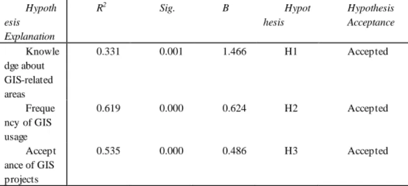
Linear regression analysis is used for specifying the one to one relations between two or more different variables. The linear regression’s dependent variable is the success in diffusion of GIS and the independent variables vary. Regression analysis is used to test Hypothesis 1, 2 and 3.
According to the F statistics significance (Sig.) values, all of the constructs are meaningful because they are below 0.05, which means that these constructs can be accepted as statistically meaningful with the confidence level of %95 and the GIS diffusion success can be explained by the related hypotheses (Table 3). The R2 values for the significant constructs show the percentage of the variance in GIS project success which is explained by the related hypotheses. B values indicate the path coefficients which mean that 1 unit change in the related independent variables will affect the GIS project success by the proportion of B values.
Hypothesis 1: Table 3 shows the result of regression analysis for Hypotheses 1. Knowledge factor about GIS-related areas
explains %33 of the variance in diffusion success, and has a positive impact by the proportion of 1.466 on GIS diffusion success.
Hypothesis 2: The result of regression analysis for Hypothesis 2 explains the frequency of GIS use by the departments of municipalities (Table 3). The significance value for this relation coefficient is less than 0.01 (Sig= 0.000); therefore, it can be concluded that there is a significant relationship between success scores and the frequency of GIS use at municipalities. Please note that the relationship is positive: as the intensity of GIS use at municipalities increases, the success in GIS diffusion increases. Therefore, our hypothesis is supported: as usage of GIS increases, so does success in the diffusion.
Hypothesis 3: For GIS diffusion to be successful, acceptance factor of GIS projects explains %54 of the variance and has a positive impact by the proportion of 0.486 on GIS diffusion success (Table 3). It is shown that there is a positive relationship between success and knowledge about GIS-related areas.
Table 3. Linear Regression Analysis of Hypotheses Hypoth esis Explanation R2 Sig. B Hypot hesis Hypothesis Acceptance Knowle dge about GIS-related areas 0.331 0.001 1.466 H1 Accepted Freque ncy of GIS usage 0.619 0.000 0.624 H2 Accepted Accept ance of GIS projects 0.535 0.000 0.486 H3 Accepted
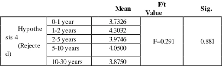
Hypothesis 4: To test Hypothesis 4, ANOVA analysis has been conducted so that GIS diffusion success is differentiated according to their usage time. The data indicate that some municipalities have been using GIS tools and application for long time, but some
other municipalities are more successful in garnering benefits from GIS projects (Table 4).
Table 4. ANOVA for Duration of Use of GIS and Success in GIS Diffusion
Mean F/t Value Sig. Hypothe sis 4 (Rejecte d) 0-1 year 3.7326 F=0.291 0.881 1-2 years 4.3032 2-5 years 3.9746 5-10 years 4.0500 10-30 years 3.8750
It can be seen that the hypothesis is rejected since the significance value (.881) is higher than .05. Therefore, there is no difference among using various GIS tools for different durations in terms of their average success.
Hypothesis 5: To test Hypothesis 5, ANOVA analysis has been conducted so that GIS diffusion success is differentiated according to the number of inhabitants in a specific municipality. Larger municipalities in Istanbul are indeed using GIS techniques but there is no concrete relation between the size of municipalities and GIS success (Table 5). Even if they are the early adopters of GIS, it does not give rise to a successful diffusion. It can be concluded from Table 7 that the largest group of GIS users, who use GIS in several departments at least, is between 50.000 and 150.000. On the other hand, relatively smaller organizations implement GIS in GIS-related departments rather than in the entire organization.
Table 5. ANOVA for Population Groups of Municipalities and Success in GIS Diffusion
Mean F/t Value Sig.
Hypothesis 5 (Rejected) Less than 20,000 people 3.3750 F=0.377 0.823 20,000-50,000 people 3.6303 50,000-150,000 people 4.1771 150,000-300,000 people 3.9531 300,000-500,000 people 4.0021 More than 500,000 4.0010 people
It can be seen that the hypothesis is rejected since the significance value (.823) is higher than .05. Therefore, there is no difference among using various GIS tools in terms of population groups living in a specific municipality.
Hypothesis 6: In addition to the size of municipalities, it is worthwhile to examine the number of GIS users in municipalities to see whether there is an effect on success of GIS diffusion or not. To test Hypothesis 6, ANOVA analysis has been conducted so that GIS diffusion success is differentiated according to the number of employees in GIS departments of municipalities. Similar to the finding regarding direct users of GIS, the total number of GIS users, no matter if they use it directly or indirectly, have no effect on success of GIS diffusion (Table 6).
Table 6. ANOVA for Number of Employees in GIS Department and Success in GIS Diffusion
Mean F/t Value Sig.
Hypothesis 6 (Rejected)
Less than 5 employees 3.9624
F=0.773 0.662
6-10 employees 3.5122
11-50 employees 4.4216
More than 50 employees 4.5000
It can be seen that the hypothesis is rejected since the significance value (.662) is higher than .05. Therefore, there is no difference among the number of employees working in GIS-related departments in terms of success in GIS diffusion.
Hypothesis 7: To test Hypothesis 7, ANOVA analysis has been conducted so that GIS diffusion success is differentiated according to the number of employees using GIS in a municipality.
Table 7. ANOVA for Number Employees in Municipalities and Success in GIS Diffusion
Mean F/t Value Sig.
(Rejected) employees
26-50 employees 4.0751
51-100 employees 4.6741
More than 100
employees 4.3438
The data indicate that the hypothesis is rejected since the significance value (.147) is higher than .05 (Table 7). Therefore, there is no difference among the number of employees in municipalities using GIS in terms of their success in GIS diffusion.
Hypothesis 8: To test Hypothesis 8, ANOVA analysis has been conducted so that GIS success is differentiated according to the satisfaction of GIS projects at municipalities. Satisfaction and success are strongly correlated with each other. If there is satisfaction about new tools or techniques, they will inevitably be successful at the end (Table 8).
Table 8. ANOVA for Satisfaction Levels of GIS Applications and Success in GIS Diffusion
Mean F/t Value Sig.
Hypothesis 8 (Accepted) Poor 1.6250 F=22.352 0.000 Fair 3.9792 Good 3.8685 Very good 4.6317
It can be seen that the hypothesis is accepted since the significance value (.000) is lower than .05. Therefore, there is a difference among satisfaction levels of municipalities with GIS in terms of their success in GIS diffusion.
7 CONCLUSION, IMPLICATIONS AND LIMITATIONS
This study intends to develop a better understanding of the nature and success of GIS diffusion at municipalities in Istanbul. An extensive survey has been conducted about GIS, diffusion process of GIS, the usage of GIS and the future of GIS. The objectives are to determine the benefits of
GIS use and the barriers to adoption at municipalities in Istanbul. Success and failure factors, as well as a better understanding of development of GIS diffusion in time, were identified. Then, the interviews are held with the experts of GIS in the field. After the survey and interviews, diffusion of GIS is analyzed in detail, hypotheses are framed and a questionnaire was generated and delivered to municipalities in the online environment. At the end of data gathering process, descriptive statistics, reliability tests, regression and ANOVA analyses are performed by using SPSS 15 with data collected from 40 municipalities. Since Istanbul is the largest city in Turkey with its population of nearly 15 million people, the questionnaire is focused on municipalities in Istanbul. All municipalities have participated in this study. Based on the research findings of analyses in previous sections, the conclusions are as follows:
Since GIS tools have concrete superiority over CAD tools, GIS is useful and should be used in all departments by all municipalities in Turkey.
Almost all departments of municipalities should use GIS tools for some applications.
Awareness is a key factor for a successful implementation but education is the least important factor to affect success. Examining successful projects and successful
municipalities are the most important factors which should be evaluated very carefully before implementation.
In implementing GIS systems, some municipalities just buy a system from a supplier end introduce this into the organization.
Budget, managerial support, useful data and number and quality of employees are key factors for non-user municipalities to use GIS in the future.
Technical departments and GIS-related departments within a municipality take the
initiative to implement GIS tools in their departments and the entire organization.
Municipalities are not the only decision-makers.
Live projects will be successful eventually which refers to the acceptance of that project and cultural norms at municipalities.
Knowledge and experience exchange should be increased among municipalities.
Because of their requirements and power, municipalities are perfect organizations to use GIS tools.
Municipalities mainly perform registration and maintenance functions instead of support in the decision-making process.
Another important conclusion is that half of the municipalities, which have started to implement GIS, accomplish this without a vision or a plan for the future.
An important failure factor to implement GIS is the fact that 49% of the GIS users do not have a policy.
7.1 Success and Failure Factors
The diffusion process of IT/IS technologies increases the interaction between organizations and citizens. IT/IS technologies will be accepted and diffused in a governmental organizations if its advantages are proven. Before and after implementing IT/IS technologies, the advantages and disadvantages of them should be clearly defined.
Success factors, as a summary of findings of questionnaires, are as follows:
Determination and support of the management and the organization
Desire to accept changes
Examination of successful projects and municipalities
Personnel capacity and education
The leader who puts GIS on the agenda
Accurate consultant selection
Budget
High quality of data
Live projects
Failure factors, as a summary of findings of questionnaires, are as follows:
Low quality and redundant data
Time not decided upon carefully
Not enough personnel
Neither attention nor support of the management.
Not enough budget
Departmental barriers
Changes of tasks
About the Author
Mahmut Çavur is a PhD candidate in Geodatic and Geographic Information Technologies (GGIT) at Middle Easth Technical University in Turkey. He is the owner of the MIneSoft Consultancy Company in Turkey working on open source GIS software and dispatching system.
REFERENCES
Burrough, P.A., 1986, Principles of Geographical
Information Systems for Land Resources
Assessment (Oxford: Clarendon Press).
Carrara, A., M. Cardinali, F. Guzzetti, and P. Reichenbach, 1999, Use of GIS Technology in the Prediction and Monitoring of Landslide Hazard. Natural Hazards, 20(2), 117–135.
Carrera, F., 2004, City Knowledge: An Emergent Information Infrastructure for Sustainable Urban Maintenance, Management and Planning. (PhD Dissertation, MIT).
Carter, J.R., 1989, On Defining the Geographic Information System. In Ripple W.J. (Ed.), Fundamentals of Geographic Information Systems: A Compendium, Proceedings of ASPRS/ACSM 1989, Falls Church, Virginia, November 1989, 1, 3-7.
Dangermond, J., 1987, GIS trends and comments, ARC News, Summer/Fall, 13-17.
De Man, E., 1988, Establishing E Geographical Information System in Relation to Its Use: A Process of Strategic Choice. International Journal of Geographical Information Systems, 2(2), 245-61.
DeMers, M.N., 1997, Fundamentals of Geographic Information Systems (New York : Wiley).
Demographia, Istanbul District Municipalities:
Population & Density (2000),
http://www.demographia.com/db-istanbul.htm Devine, H.A. and R.C. Field, 1986, The Gist of GIS.
Journal of Foresty, 84(8), 17-22.
ESRI, Municipalities and Cooperatives (n.d.), http://www.esri.com/library/brochures/pdfs/gis-for-municipalities.pdf
Service Nova Scotia and Municipal Relations, 2001, Section 5.4: GIS for Municipalities, Local Government Resource Handbook, , April 2001, http://www.gov.ns.ca/snsmr/muns/manuals/PDF/L GRH/LocalGovernmentResourceHandbook_5.4.p df
Hicks, J., 1993, Experiences with Compiler-Directed Storage Reclamation in Proceedings of IFPCA 93 on Functional Programming Languages and Computer Architecture, New York, NY, June 1993, 1, 95-105.
Ilmavirta, A., 1995, The Use of GIS-System in Catastrophe and Emergency Management in Finnish Municipalities. Computers, Environment and Urban Systems, 19(3), 171-178.
Istanbul Nufus ve Demografik Yapi [Population and
Demographic Structure of Istanbul],
http://www.istanbul.net.tr/istanbul_istanbul_nufus. asp
Longley, P.A., M.F. Goodchild, and D.J. Maguire, 2001, Geographical Information Systems and Science (New York: Wiley).
Maguire, D.J., 1991, An Overview and Definition of GIS. In Maguire, D.J., M.F. Goodchild and D.W. Rhind (Eds.), Geographical Information Systems: Principles and Applications, (Harlow: Longman), 1, 9-20.
Martin, C. and P. Powell, 1992, Information Systems - A Management Perspective (Maidenhead: McGraw Hill).
Noongo, E.N., 2007, The Implementation of Geographic Information Systems in Namibia. (Finland: University of Joensuu)
Rogers, E.M., 1995, Diffusion of Innovations Theory (New York: Simon and Schuster).
Sahin, I., 2006, Detailed Review Of Rogers’ Diffusion of Innovations Theory and Educational Technology-Related Studies Based on Rogers’
Theory. The Turkish Online Journal of
Educational Technology, 5(2), 14-23.
Samadzadegan, F., S. Saeedi, A. Alvand, and M. Hasanlou, 2008, Enterprise GIS for Municipalities – A Service Oriented Approach in Proceedings of The International Archives of the Photogrammetry, Remote Sensing and Spatial Information Sciences , Beijing , China, 37, Part B4, 1133-1136.
Van Driel, N., 1991, Geographical Information Systems for Earth Science Applications in Proceedings of IV. International Conference on Seismic Zonation, Stanford, California, Aug. 1991, 1, 469–485.
Yomralioglu, T., 2004, Developing Infrasructure Potential in Turkey with GI. GEOInformatics, 7 (April/May), 52-55.
Yomralioglu, T., 2002, GIS Activities in Turkey in International Symposium on GIS, Istanbul, Turkey, September 2002.
View publication stats View publication stats