DIFFUSION OF SKILL IN THE MEDITERRANEAN WORLD.
OTTOMAN NAVIGATIONAL TECHNOLOGY
DURING THE 16™ CENTURY
SEEN THROUGH SAILING-DIRECTIONS MANUALS
A Master’s Thesis
By
DIMITRIOS LOUPIS
DEPARTMENT OF HISTORY
BILKENT UNIVERSITY
ANKARA
September 2004
DIFFUSION OF SKILL IN THE MEDITERRANEAN WORLD.
OTTOMAN NAVIGATIONAL TECHNOLOGY
DURING THE 16™ CENTURY
SEEN THROUGH SAILING-DIRECTIONS MANUALS
THE INSTITUTE OF ECONOMICS AND SOCIAL SCIENCES
OF
BILKENT UNIVERSITY
by
DIMITRIOS LOUPIS
In Partial Fulfillment of the Requirements for the Degree of
MASTER OF ARTS
m
THE DEPARTMENT OF HISTORY
BiLKENT UNIVERSITY
ANKARA
September 2004
I certify that I have read this thesis and have found that it is fully adequate, in scope and in quality, as a thesis for the degree of Master of History.
Assistant P rof Mehmet Kalpaklı Supervisor
I certify that I have read this thesis and have found that it is fully adequate, in scope and in quality, as a thesis for the degree o f Master of History.
Assistant P rof Oktay Özel Examining Committee Member
I certify that I have read this thesis and have found that it is fully adequate, in scope and in quality, as a thesis for the degree of Master of History.
Associate Prof Suavi Aydın Examining Committee Member
Approval of the Institute o f Economics and Social Sciences.
Prof Dr. Kürşat Aydoğan Director
ABSTRACT
DIFFUSION OF SKILL IN THE MEDITERRANEAN WORLD. OTTOMAN NAVIGATIONAL TECHNOLOGY
DURING THE 16™ CENTURY
SEEN THROUGH SAILING-DIRECTIONS MANUALS Loupis, Dimitrios
M.A., Department of History
Supervisor: Assist. Prof. Dr. Mehmet Kalpaklı
September 2004
This thesis deals with the navigational technology, focusing on the sailing- directions texts, of the Ottomans during the 16^'’ century. It is divided into four chapters, the first of which discusses in general the development of the science and technique o f navigation in the Mediterranean Sea from the Antiquity to the 16* century. The subject of the study is the technology that has to do with the orientation and not with the ship-building at all. A brief reference on the instruments used on ship board follows, while the chapter ends with the distinction between the astronomical and the plane navigation. The second chapter displays the Mediterranean world as a unity, where all sorts of exchange and interaction took place. Thus, the art of navigating the sea, that both unites and divides the shores around it, was one of the main features of the cultural exchange. The mariners of the enclosed sea shared a common life in the waters no matter their ethnic and
religious provenance. Here the common language of the seamen, the “lingua franca” is under consideration. The third chapter discusses the sailing-directions text that were compiled in various languages again from the Antiquity to the 16* century, while the fourth and last chapter is concentrated on the three known 16*- century Ottoman texts of this genre.
The Ottomans, as well as other Mediterranean groups, were in the periphery of the navigational technology according to the results o f the study. They produced a small number o f original texts, nevertheless they took part in the diffusion of the navigational know-how.
Keywords; navigation, navigational technology, sailing-directions texts, Piri Reis, Haci Muhammed Reis
ÖZET
AKDENİZ DÜNYASINDA BECERİNİN YAYILMASI. 16. YY.’DA OSMANLI DENİZCİLİK TEKNOLOJİSİ
OLARAK DENİZ KILAVUZLARI Loupis, Dimitrios
Yüksek Lisans, Tarih Bölümü
Tez Yönetieisi: Yrd. Doç. Dr. Mehmet Kalpaklı Eylül 2004
Bu tez Osmanhlar’ın 16. yy’da denizcilik teknolojisi, özellikle deniz kılavuzları üretimine katkısını incelemektedir. Tez dört bölümden oluşmaktadır. Birinci bölümde genellikle eski çağlardan 16, yüzyıla kadar Akdeniz’de denizcilik bilim ve tekniği gelişmesi ele alınıyor. Bu araştırmanın asıl konusu yönlendirmeyle ilgili teknolojidir, gemi inşaatı konusuna değinmemiştir. Gemide kullanılan aletler hakkında kısa bir tanımlama verilimiştir. Bu bölüm, astronomik ve yüzeysel denizcilik terimlerinin açıklamasıyla sona ermektedir. İkinci bölümde her karşılıklı değişme ve etkileşimin gerçekleştiği bölge gibi Akdeniz dünyası bir bütün olarak inceleniyor. Böylece, denizcilik sanatı kültür değişmesinin baş özelliklerinden biri oluyor. Etnik ve dinsel kökene önem vermeden o kapalı denizin denizcileri sularda ortak bir hayat yaşıyorlardı. Bu bölümde denizcilerin ortak şivesi (Lingua Francaj’dan bahsediliyor. Üçüncü bölümde eski çağlardan 16. yüzyıla kadar Akdeniz’de diğer dillerinde üretilen deniz kılavuzları inceleniyor. Dördüncü ve son bölüm lö.yy’da Osmanlıca yazılan o tür metinlerini takdim ediyor.
Bu araştırmanın sonuçlarına göre, Osmanlılar, diğer birkaç Akdeniz grubu ile, denizcilik teknolojisinin merkezinde değil, onun çevresinde bulunmuşlardı. Onlar orijinal olarak az miktarda metin üretti, ama denizcilik bilgisinin yayılmasına katıldılar.
Anahtar Kelimeler: denizcilik, denizcilik teknolojisi, deniz kılavuzları. Piri Reis, Hacı Muhammed Reis
ACKNOWLEDGEMENTS
This thesis represents the result of a three-year residence in Turkey and it is only one among the precious fruits I gathered from that charming experience. Now that I have my luggage fulfilled by invaluable things, which I acquired during my apprenticeship period in Bilkent University, I would like to thank people, who kindly assisted me. I owe a lot to them and for sure all positive points of that interaction are to be met in the following thesis.
I would like to thank my advisor. Assist. Prof. Mehmet Kalpaklı, who made all efforts to ease my stay and study at Bilkent. I am, also, indebted to Assist. Prof Oktay Özel, who has been an inexhaustible source for my queries and puzzles throughout all those years. I thank Mr. Özel and Assoc. Prof Suavi Aydın for having participated in the examining committee. Their experience and judgment were so readily available.
During my scientific inquiries I was assisted by Dr. George Tolias, Dr. Evangelia Balta, Dr. José Barrai, Mr. Divo Basic, to whom I would like to express my gratitude. My family and friends encouraged and incited me constantly; I owe my endurance to them. I would, also, like to thank Prof Chryssa Maltezou, Director of the Hellenic Institute for Byzantine and Post-Byzantine Studies in Venice, whose kind offer of lodging made my research in Venice comfortable.
The study and research was substantiated by the generous support of Bilkent University, which gave me the opportunity to pursue post-graduate studies in Turkey, and the Suna & İnan Kıraç Research Institute on Mediterranean Foundation - AKMED (Antalya).
TABLE OF CONTENTS
ABSTRACT...iii ÖZET... iv ACKNOWLEDGEMENTS... v TABLE OE CONTENTS... ix TABLE OF FIGURES...xi INTRODUCTION...1CHAPTER 1. Aegean Lake, the West, Pax Ottomanica and the displacement of the Umbilicus Terrae...7
CHAPTER 2. Navigation and navigational technology...17
CHAPTER 3. Common share and diffusion of skill... 25
CHAPTER 4, Sailing-directions texts... 31
CHAPTER 5. Ottoman sailing-directions texts... 46
5.1 V‘mK&'\'s,,Kitab-i B a h riyye... 54
5.2 H acıMuhammed ReTs, Tuhfetü'1-esrârf i tarîki’l-bihar... 80
5.3 The Anonymous Borgian Portolans...87
Bm U O GRA PH Y ...104 APPENDICES... 141 A. T ext from Pîrl R e’Is, Kitab-i Bahriyye... 142 B. Text from Hacı Muhammed ReTs, Tuhfetül-esrârJîtarTki’l-bihâr ...144 C. Texts from the Anonymous Borgian Portolans...146 FIGURES... 148
Fig. 1. The oldest extant Arabic compass. It was used for navigation in the Indian Ocean. Date 1 Cent ur y... p. 149 Fig. 2. Arabic astrolabe... p. 150 Fig. 3. Portolan-chart of the Adriatic Sea by Placido Caloiro Oliva, 1649.
Dubrovnik, Maritime M useum... p. 151 Fig. 4. Portolan-chart of the type “normal portolano” by Albino de Сапера,
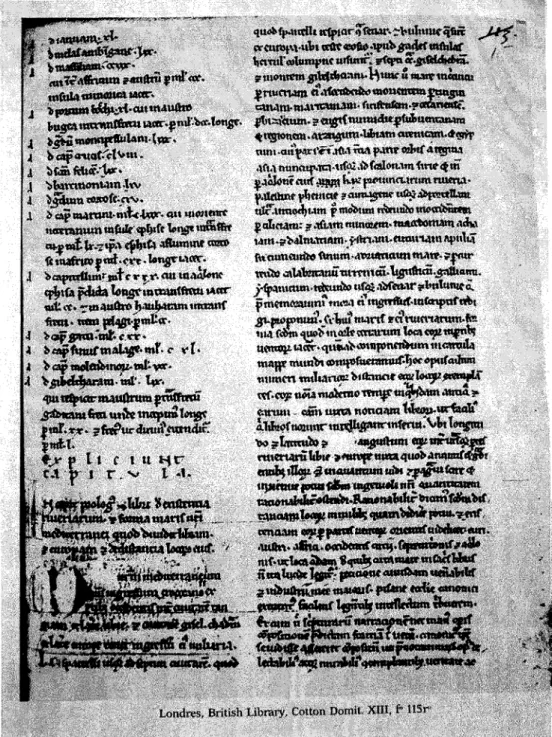
1489...p. 152. Fig. 5. The earliest known portolan-text of the Early Modern Times. Page from the
Liber de Existencia Riveriarum et Forma Maris nostril Mediterranei, Pisa, circa 1200... p. 153 Fig. 6. The Euboia Island. From the printed book of the islands, Isolario by
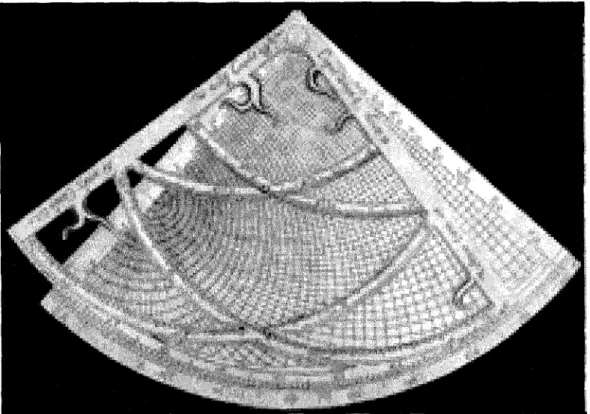
Bartolommeo dalli Sonetti, Venice ca. 1485...p. 154 Fig. 7. Arabic quadrant... p. 155 Fig. 8. Arabic Maghrebian portolan-chart of Ibrahim al-Mursi, 1461. Istanbul,
Maritime Museum Nr. 882...p. 156 Fig. 9. The island of Naxos from Cristoforo Buondelmonti’s Liber Insularum
Archipelagi, ca. 1420-1430. Paris, Bibliothèque Nationale, MS. Eat. Nouv. Acq. 2383, f. 22v... p. 157
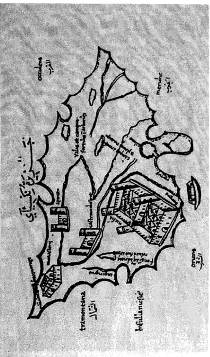
Fig. 10. The island of Leucada from the Phi Reis, Kitab-i Bahriyye, 1520-1526. From a frrst version copy held in Kiel, University Library, MS. Ori. 34, f. 42a... p. 158 Fig. 11. Tripolis of Beymt. From the Pin Reis, Kitab-i Bahriyye, 1520-1526. A
second version copy held in Istanbul, Maritime Museum...p. 159 Fig. 12. Hacı Muhammed R e’is, Tuhfetü’l-esrár j t tariki’l-bihar. Istanbul, Siileymaniye Libraiy, MS Esad Efendi 3782/35, f. 94b...p. 160 Fig. 13. Portolan-chart of the Aegean by Mehmed Reis Menemenli, 1590-1591. Venice, Museum Civico Correr, Port. 22... p. 161 Fig. 14. Portolan-text from the anonymous Borgiano 2. Vatican, Biblioteca
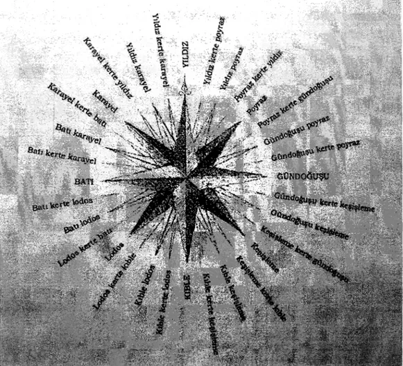
Apostólica Vaticana, Borgiano Turco72, f 31a... p. 162 Fig. 15. Windrose with Turkish terminology. From RASİM BARKINAY, Ahmet.
Adalar Denizi kılavuzu. İnözden Marmaris Burnuna kadar, çeviren Mustafa Pultar (İstanbul: Tetragon, 2002), vii...p. 163
INTRODUCTION
The study o f the history of technology or history of science has gained field during the recent decades, while attracted the interest of not only historians, but also scholars from the positive sciences. Although, there were a few sporadic studies on the Ottoman world of technology published since the 1930’s, the research was intensified during the last twenty years. Nevertheless, this field, among others in Ottoman historiography, needs more thorough and long effort in order to acquire the scheme of the development of science, scientific methods and practice within the time limits o f the Ottoman period.
Some twenty years after the publication of an unsuperable article by Franz Taeschner on Ottoman geography, ‘ the fundamental work by Adnan Adivar Osmanli Türklerinde ilim appeared in the 1940’s.^ It served the field well for quite a long period, nevertheless, during the almost seven decades that passed since, a great amount of new knowledge has been accumulated. The two works of Ignatii Krachkovski on the nautical literature of the Arabs and Ottomans in 15* and 16* century and on the history of Ottoman geographical literature of the 15*-19* ' TAESCHNER, Franz. “D ie geographische Literatur der Osmanen.” Zeitschrift der Deutschen Morgenländischen Gesellschaft N.F. 2 (1923): 31-80.
■ Here studied in the expanded edition; ADIVAR, A. Adnan. Osmanli Türklerinde ilim
centuries did not find readers in the western Ottomanists circles? Apart from the general and comprehensive book of Adivar, there were other publications specialized in narrower topics, such as the field of Ottoman geography, cartography and hydrography, which is the subject o f this thesis. Ibrahim Hakkı Konyah published his Topkapi Sarayında deri üzerine yapılmış eski haritalar in 1936.“^ This was the first effort to collect the Ottoman mapmaking production and present it through the items preserved in the richest o f Turkish collections, the Topkapi Palace Library. Not only Ottoman-Turkish, but also Islamic and Western maps were included in that study, thus giving a general and preliminary idea of the Ottoman sultans and their entourage’s geographical and cartographical interests. This study was also a first indicator of the Ottoman technology of the space and its products. The interest in Ottoman cartography was bom during the late 1920’s, when the PîrT R e’îs map of the 1513, that provides an early depiction of America, was discovered and presented to the international scholarly society. Paul Kahle was the main orientalist, who made the map known with a series of publications and lectures in various languages all around the world. The same scholar published as well PîrT ReTs’s opus magnum Kitab-i Bahriye, the Book on Navigation in 1926.^
^ КРАЧКОВСКИЙ, Игнатий Юлианович. “Турецкая географическая литература XV-XIX вв.” И. Ю. Крачковский, Избранные сочинения (Москва; Академия Наук СССР, 1957), 4: 589-656. КРАЧКОВСКИЙ, Игнатий Юлианович. “Морская география в XV-XVI вв. у Арабов и Турок.” Геогра(рический Сборник 3 (1954): 13-44. Reprinted in И. Ю. Крачковский, Язбронные сочинения (Москва: Академия Наук СССР, 1957), 4: 547-588. '' KONYALI, İbrahim Hakkı. Topkapi Sarayında deri üzerine yapılmış eski haritalar (İstanbul: Ülkü Basmıevi, 1936).
This acted on new publications and studies on the Pin Re Is phenomenon and his magisterial scholarship.
Today the list of monographs and articles published on PTrl ReTs and his works is very long. Nevertheless, mainly the cartographic part of his Book on Navigation attracted the interest of the scholars and the text itself was rarely seen as a sailing-directions text within the frame of a navigation-technological trend in the Mediterranean world o f the 16th century. The vast majority of the scholarship on Plrl R e’Is was concentrated on strictly Ottoman matters and bibliography, while the well studied nautical texts of the Latin, Italian, Spanish, Greek, Arabic, French and English productions were parsimoniously taken into consideration. This attitude of the Ottomanist’s circles has often accepted the accusations by historians of other geographies and periods. The Ottoman world should always be seen as a part of the Mediterranean and European realities. Not only political, but also cultural and scientific developments in that wider geographical space, in terms of genesis, diffusion, and interaction, were not limited within the borders of the states. On the contrary, they were connected in a more expanded net of relations.
This short study is concentrated on the Ottoman production of navigational know how, especially the sailing-directions texts of the 16th century. The period was chosen, because during that time the first texts o f this kind appear in the Ottoman world. This was an era enthusiastically named “golden epoch” or “century of the sea” in Ottoman historiography. After the consolidation of the imperial
power during the reign of Mehmed the Conqueror, Suleyman’s time, that is the 16th eentury more or less, was the period, when the Ottoman navy and the ships under Ottoman flag met in terms of shipbuilding, seamanship, power, victories, wealth and growth with a successful development. Moreover, this time was the period, when the “Ottoman system” took its final shape, the institutions that sustained it functioned eificiently, and the “Ottoman identity” constituted a reality.
The first chapter is a brief introduction to the historical relations of the Turkish principalities of Eastern Asia Minor and the Ottomans till the 16th century with the sea and the art of seamanship. The Aegean Sea was of core importance to the Ottomans due to its geographical position, because it protected the dominion’s capital. This enclosed sea should be part of the Ottoman territory in order that the central power was secured. And this is what the Ottoman fleet tried to accomplish since the late 15th century, while the biggest part of the project was completed in the mid-16th century. In the same chapter the relations of the Ottomans with the Western powers, the establishment of Pax Ottomanica in the Eastern Mediterranean and finally, the displacement of the center o f interest from the old world of the Mediterranean to the new field o f the Atlantic Ocean, after the incorporation of America to the European affairs, are the topics in discussion. This is in order to give the historical frame in connection with maritime matters, and depict the terrain and reasons for the Ottoman navigational technology to take place.
The second chapter deals with the development of navigation and navigational technology in the Mediterranean during the late Medieval and early
modem times. This technology is connected to the orientation. Nautical instmments, which were used on board, the two types of navigation and a variety of terminology are discussed.
The common share and the diffusion of skill among the Mediterranean mariners is the topic of the third chapter. Seamen from various religious, ethnic and state provenances met each other on still or stormy water, lived more or less the same life, had the same fate and together with being the intermediaries for a series of exchanges, they shared navigational techniques as well. A result of that osmosis was a common language, the “lingua franca” with words of Italian, Greek, Turkish, Arabic, Spanish and Slavic languages.
The fourth chapter goes into the evolution of the genre of sailing-directions texts in the Mediterranean from the Antiquity to the 16th century. Ancient Greek and Roman, Byzantine, Latin, Italian, Early Modem Greek, Arabic, Spanish, Portuguese, French and English products o f this kind are studied.
Finally, the fifth chapter deals with the Ottoman’s reaction towards the production of that specified technological manuals. The research done resulted into three texts within the time limits set. PirT ReTs’s Kitab-i Bahriyye, compiled in 1520-1526, is the first sailing directions written in the Ottoman language. It is a mixed sort of text with other dimension as well, but here the study is focused on its character as a portolan-text. Towards the end of the 16*'’ century H a d Muhammed R e’Ts appears to be the author of a pure text of this kind, which gives the distances between two spots all around the coastline of the Mediterranean Sea. A third work
of the same content is a couple of portolan-texts called the Borgiano Portolans. They are preserved in a single copy, which may be dated in the late 18* century, but its technology is closer to the 16th-century portolans.
This is the general scheme of the thesis, which is a preliminary study of a technology hitherto very little known to the Ottomanists and the historians of navigation. The thesis will attempt to answer to questions, such as how the Ottomans reacted in this specific genre o f navigational manuals, did they produce original works, and, did they take part in the diffusion of skill among the Mediterranean maritime powers? Additionally, this study will deal with the problems of authorship, date of composition, the sources and other issues emerging from the analysis o f the three texts that consist the main body of the thesis.
CHAPTER ONE
AEGEAN LAKE, THE WEST, PAX OTTOMANICA, AND THE
DISPLACEMENT OF THE UMBILICUS TERRAE
Since the era of the Turkic emirates of Asia Minor, when the nomadic tribes of Central Asiatic provenance were taking part in rapid cultural evolution, it became a requisite for the new inhabitants of the Mediterranean world to approach the unknown for them element of the sea.^ The miniature states of the gazis,’ which based their economy on booty acquired through conquest, occupied already since 13* century the significant port of Attaleia (Antalya),^ while the emirate of Menteşe was practicing piracy in a way to discover new financial resources since the beginning of the same century. The Eastern Roman state was at death’s door, since it had made entirely its trade over to Genoese and then to Venetian hands, who managed to become the main middlemen of the commerce of products ifom
^ See CARRETTO, Giacomo E. Akdeniz’de Tilrkler, çev. Durdu Kundakçı - Gülbende Kuray (Ankara: Türk Tarih Kurumu, 1992), 9-11.
^ WITTEK, Paul. The Rise o f the Ottoman Empire (London; The Royal Asiatic Society of Great Britain and Ireland, 1938; repr. 1958), page 30 o f the Greek translation: Athens 1988. For the war o f gazis in the Aegean see PRYOR, John H. Geography, technology, and war. Studies in the maritime history o f the Mediterranean, 649-1571 (Cambridge: Cambridge University Press, 1992), 167ff.
* WITTEK, op. cit., 57. PRYOR, op. cit., 165 ff. See, also, WITTEK, Paul. Das Fürstentum Mentesche (Istanbul: Abteilung Istanbul des Deutschen Archäologischen Institutes, 1934).
the East that were imported from Europe during those centuries. At that time, the center o f financial power was moved towards the West in order to sustain the blossoming of the Italian cities and to activate, with the support o f the colonies in Greece, the gradual decay of Constantinople. The Middle Byzantine dominance over Eastern Mediterranean was already a past.^ Its shipbuilding installations, though, recm desced’” in order to serve the new order.
Over the Aegean shores of the post-Seldjukid” Asia Minor the pirate-state of Menteşe in collaboration with the emirate o f Aydın created a fleet, which under
Ahrweiler in her important study on the sea and navy o f Byzantium concludes that the Byzantine navy, which was created in order to serve the idea o f reconquest o f the old Roman lands, was impoverished together with the damping o f the idea that generated it (see AHRWEILER, Hélène. Byzance et la mer. La marine de guerre, la politique et les institutions maritimes de Byzance aux Vlle-Xve siècles (Paris: Presses Universitaires de France, 1966), 394), since Byzantium remained always a continental power without significant performances in the naval things: ‘Byzance reste, bor gré mal gré et avant tout, un empire continental dont la vraie base fut toujours l ’Orient, étranger aux choses de la mer.. .'\op. cit., 395).
'° KAHANE, Henry & Renée and Andreas Tietze. The lingua franca in the Levant. Turkish nautical terms o f Italian and Greek origin (Urbana: University o f Illinois Press, 1958; repr. Istanbul: ABC, 1988), 10-13, and ΜΠΕΚΙΑΡΟΓΑΟΥ-ΕΞΑΔΑΚΤΥΑΟΥ, Aik. Οθωμανικά vaoKqyeia στον παραδοσιακό ελληνικό χώρο (Αθήνα: Πoλıτtστıκó Τεχνολογικό Ίδρυμα ΕΤΒΑ, 1994), 11-12.
" The first naval raids of the Turkic tribes against the Byzantines are dated in the era o f the Seldjucid Sultanate o f Rum. The Seldjuk lord o f Nicaea (İznik) Ebulkasim (see ZACHARIADOU, Elizabeth. “Holy war in the Aegean during the fourteenth century.” In
Latins and Greeks in the Eastern Mediterranean afler 1204, edited by B. Arbel, B. Hamilton, and D. Jacoby (London: Totowa, 1989), 212, and PRYOR, op. cit., 113) was followed by the emir o f İzmir Caha or Çaka, who was doing raids in 1081-1106 onto the Asia Minor coasts, the islands o f Eastern Aegean and the sea o f Marmara (the important port o f Abydos). He created a strong fleet with the assistance o f a Christian from Smyme, who was experienced in maritime matters. See ΣΑΒΒΙΔΗΣ, Α.Γ.Κ., ‘Ό Σελτζούκος εμίρης της Σμύρνης Τζαχάς (Çaka) και οι
επιδρομές του στα μικρασιατικά παράλια, τα νησιά του ανατολικού Αιγαίου και την Κωνσταντινούπολη, c. 1081-c. 1106.” Χιακά Χρονικά 14 (1982):9-24 & 17 (1984): 51-66. Nevetheless, Byzantium and the Sultanate o f Rum managed to put an end to his activities with his assassination. For Çaka see also KURAT, Akdes Nimet. Çaka Bey. İzmir ve civarındaki ilk Türk Beyi, MS 1081-1096 (Ankara: Türk Kültürünü Araştırma Enstitüsü, fr966). For the naval activities o f tlie Turkic emirates o f Asia Minor see İNALCIK, Halil. “The rise o f tlie Turcoman
the guidance of Gazi Umur B eg’^ was doing raids over the Macedonian and Thracian coasts. The sea gazis^^ of Aydın were the forerunners of the Ottoman conquerors in the Greek lands and the trade that their state did with Venice was the usher of the Venetian-Ottoman commercial relations.A dditionally, the Ottomans were assisted on the sea by the fleet o f the emirate of Karasi, with which they passed to the Greek peninsula,''^ while they founded their first significant dockyard with the conquest of Kallipolis in 1390. Smaller dockyards of them were already active in Prainetos (Karamürsel), Kyzikos (Edincik), and Nicomedia (İznikmid, izmid). Shortly their number would be increased dramatically in the regions of Propontis (Marmara Sea), the Black Sea and the eastern shores of the Aegean.’^ The conquest of the Greek island and continental territories was evolving rapidly
maritime principalities in Anatolia, Byzantium and the Crusades.” Byzantinische Forschungen 9 (1985); 179-217. ЖУКОВ, К.A. Эгейские эмираты в XIV-XVее. (Москва 1988).
'^ZACHARIADOU, op. cit., 215 ff. PRYOR, op. d t . , \ Ы - П \ .
WITTEK, op. cit., 58.
ZACHARIADOU, Elizabeth A. Trade and crusade. Venetian Crete and the emirates of Menteshe and Aydin, 1300-1415 (Venice: Hellenic Institute o f Byzantine and Post-byzantine Studies, 1983), 3.
HALAÇOĞLU, Yusuf. XIV-XVJI. yüzyıllarda Osmanhlarda devlet teşkilâtı ve sosyal yapı
(Ankara: Türk Tarih Kurumu, 1991), 52 ff.
MHEKIAPOTAOY-EHAAAKTYAOY, op. cit., 84-86, HALAÇOĞLU, op. cit., 54, BOSTAN, İdris. Osmanlı bahriye teşkilâtı: XVII. Yüzyılda tersâne-i âmire (Ankara: Türk Tarih Kurumu, 1992), 15. For the Sultanic dockyard in Galata see MÜLLER-WIENER, Wolfgang. “Zur Geschichte des Tersâne-i Âmire in Istanbul.” In BACQUE-GRAMMONT, Jean-Louis et alii (eds). Türkische Miszellen. Robert Anhegger Festschrift-Armağanı-Melanges (Istanbul: Editions Divit Press, 1987), 253-273, and BOSTAN, İdris. “Piri R eis’in Kitab-ı Bahriyye’sinde bulunan tersane-i amire planlan.” Sanat Tarihi Araştırmaları Dergisi 1.2 (1988): 67-68.
finding as sole obstacles the Italian, Catalan and Frankish colonies, predominantly islands and ports that would be often changing lord during the consequent centuries. Since Mehmed the Conqueror, who set out for the incorporation of the Aegean shores and islands into his dominion, till Selim Yavuz and Suleyman the Lawgiver, with the Venetian-Ottoman sea fights and the expansion into the Balkans and Central Europe, the Ottoman state would be expanded'* over the old territories of the Eastern Roman Empire, in order to activate the imaginable split'^ of the Mediterranean between East and West with constantly opposing interests. Nevertheless, the old capitulations of the Europeans were renewed^" under the Ottomans with a pressure that would be gradually augmented over the centuries, while the stagnation and reorganization of the East slowly and changelessly would make the state less flexible to adjust itself into the new situations.
Since the Genoese were hold away by Mehmed the Conqueror and Beyazid I to their colonies in the Black Sea, and together with the Venetians away from most o f the Aegean, then Süleyman was able to work towards the Ottoman naval supremacy. See IMBER, C.H. ‘The navy o f Süleyman the Magnificent.” Archivum Ottomanicum 6 (1980): 211. KISSLING, H.J. “İkinci Sultan Bayezid’in deniz politikası üzerine düşünceler (1481-1512).” Türk Kültürü 7.84 (1969): 895 f f For Bayezid’s efforts see FISHER, Sydney Nettleton. The foreign relations of Turkey, 1481-1512 (Urbana: University o f Illinois Press, 1948; republished electronically in
Electronic Journal o f Oriental Studies 3.3 (2000): 1-111). CARRETO, op. cit., 27.
Braudel in his work on the Mediterranean talks for an imaginable border between East and West, where all the significant conflicts took place. This borderline may be defined by the naval battles o f Actium (31 BC), Preveza (1538), Naupactos (1571), Malta, Zama and Djerba on the Algerian peninsula.
Venice made contracts with the Ottoman state on April 18*, 1454, while France would later on block the collection o f money for the crusader activities o f the Pope. See FLEET, Kate.
European and Islamic trade in the Early Ottoman State. The merchants o f Genoa and Turkey
Since the fall of Constantinople, the fight over the ex-Byzantine Aegean concerned only the Ottomans and the Venetians,^' while a proportion of the Greek element^^ was divided into the service and support of the two powers of the region bringing together its seamanship acquired through centuries. The Ottomans, by their side, knew that, in order to make themselves present on the theater of the Mediterranean, they should possess the enclosed sea, the lake of the Aegean,^^ thus in this way they protected their capital from the south. On the contrary, the Venetians, who followed another system, in order to support their economical status needed to control the trade roads with the East, while they maintained an intra-Mediterranean system of colonies. The Ottoman financial system was the territorial expansion through conquest, on which the state resources were based. The Venetians were active though in an early type of capitalistic economy.
Before the Ottomans proceed gradually to the European system and during the classical period of the reign of the Lawgiver, the state covered a wide territory around the Eastern Mediterranean and possessed, with a few exceptions, the heart
LEWIS, Bernard. The Muslim discovery o f Europe (New York: Norton, 1982), 226. SOUCEK, Svat. Piri Reis and Turkish mapmaking after Columbus-The Khalili Portolan Atlas
(London; The Nour Foundation - Azimouth Editions - Oxford University Press, ^1996), 10-13. See, also, GUILMARTIN, J.F., Gunpowder and galleys. Changing technology and Mediterranean warfare at sea in the .sixteenth century (Cambridge: Cambridge University Press, 1974).
"" For the supply o f material to the Suleyman’s navy by Greeks, see M B E R , op. cit., 231 ff. For Greek craftsmen and experienced mariners in it, see p. 242 ff.
23
9.
of the region that is the A e g e a n . I n the beginning, by granting protection to pirates and then with their incorporation the Ottoman state made use of the nautical past of the region and managed to develop a fleet, which was equal to its continental achievements. The Ottoman order and the mechanism of the revenues were functioning, as soon as the conquests went on. Their interception would denote the recall of the power over land and sea. The tile of the “Ruler of the Seas and Lands” (Hâkânü’l-bahreyn Sultânüd-berreyn)^^ would not follow the Ottoman sultan for long after the sea battle of Naupactos/Lepanto (1571). And not only because the Santa Lega of the Pope and the European kings managed to impose its power at least over the Western and Central Mediterranean, but because Naupactos came to reveal with the losses of both sides that it was one of the last serious intra- Mediterranean conflicts of East-West. The Ottoman naval power was still strong since two important island conquests took place in Cypms the same year and in Crete a century later.
“ In a total o f 222 charts in the PM R e’Is Kitab-i Bahrfyye copy of Siileymaniye, MS. Ayasofya 2612, 76 depict the Aegean and coasts o f the Greek peninsula, 30 the eastern coasts of the Adriatic, 44 the Italian shores, 8 the French and Spanish shores, 35 the Northern African ones, 7 the Eastern Mediterranean coasts, 19 the southern Asia Minor shores and 3 the Marmara Sea.
25
The fleet o f the Ottoman state was never permanent, like in Western Europe, but was organized by every sultan from the beginning. For the fleet o f Bayezid see KISSLING, H.J. “Betrachtungen Uber die Flottenpolitik Sultan Bayezids II, 1481-1512.” Saeculum 20 (1969): 35-43. See, also, FISHER, op. cit. For Süleyman’s fleet see IMBER, op. cit., and KAHANE- TIETZE, op. cit., 17-20.
MHEKIAPOFAOY-EEAAAKTYAOY, op. cit., 12. The same title was used by the Seldjukid sultan İzzeddin K eykaw s smce 1215: “Sultânü’l-berrî v e’l-bahr.”
It is not without reason that the 16* century was named the “century of the sea” in Ottoman historiography. During this period the dominance over the sea was reinforced, a rather sine qua non element for a Mediterranean power, and stabilization took place. Consequently Pax Ottomanica was able to be established. The fight in the sea was the reason for the development of nautical science was developed by the Ottomans. On the other hand, apart from the same reason, there was a series of other factors, such as the facilitation of sea trade, and the emergence of the phenomenon o f Renaissance with the cultivation of the positive sciences and the faith on their methods, that were important for the evolution of the nautical science first in Italy and then in other Western Mediterranean powers.
The old world of the Mediterranean Sea^^ with the evolvement and amelioration of the navigational manuals reached a high point of precision in the depiction and description of space. After the discovery of new routes to the resources of the Orient, and the revelation of new lands and continents, that old world became a witness of the displacement of the center of earth to another greater sea, which was going to become during the following centuries the cradle of interest. The exhausted and overcharged world of the Mediterranean basin quested for its rejuvenation with two ways, that was with social reconstruction of the classes and reorganization of ideas and principles for the Italian people and the
ADIVAR, A. Adnan. Osmanli Türklerinde ilim (İstanbul: Remzi, ^1991), 71.
After 1620 or 1650 it certainly is not the center o f the world any more according to Braudel. For the enlargement o f the world see NEBENZAHL, Kenneth. Maps from the age of discovery. Columbus to Mercator (London: Times Books, 1990), viii.
28
central-western lands o f Europe, and with colonizing expansion outside o f the basin for the non-Mediterranean Portuguese, the Spaniards and later on the Dutch. Already before the gradual revelation of America, the theater of the conflicts outside of the Mediterranean core was concentrated in the Indian Ocean,^*^ where Portuguese and Ottomans were in search of territorial, economical and religious predominance.
The 16* century in terms of the development of navigational manuals in the Mediterranean was a period of intense scientific and practical endeavor. It was the last effort o f the Mediterranean peoples to give a written form of their perception of their own space, to conceive and describe it. Soon the naval developments would be far more intense and fruitful in other seas than the Mediterranean. The locals would gradually lose power, which was gained by non-Mediterranean states.
ÖZBARAN, Salih. The Ottoman response to European expansion. Studies on Ottoman- Portuguese relations in the Indian Ocean and Ottoman Administration in the Arab Lands during the sixteenth century (Istanbul: The Isis Press, 1994). ÖZBARAN, Salih. Yemen’den B asra’ya smirdaki Osmanli (Istanbul: Kitap Yayınevi, 2004). SAFFET, B. “Bir ‘Osmânlı filosunun Sumatra seferi.” Târîh-i ' O smâni Encümeni Me cmü'ası 1 (1912): 604-614 & 678-683. BACQUE-GRAMMONT, J.L., et A. Kroell, Mamlouks, Ottomans et Portugais en mer Rouge. L ’ajfaire de Djedda de 1517 (Le Caire: IFAO, 1988). ORHONLU, Cengiz. Osmanh İmparatorluğu’nun güney siyaseti. Habeş eyaleti (Ankara: Türk Tarih Kurumu, 1996). For the use o f Islamic charts and sailing directions texts in the Indian Ocean, see TIBBETTS, G.R.
Arab navigation in the Indian Ocean before the coming o f the Portuguese, being a translation
of Kitab al-Fawa’id fi u.şû! al-bahr w a ’l-qaw a’id of Ahmad b. M ajid al-Najdi (London: The Royal Asiatic Society of Gret Britain and Ireland, 1971).
In the Book on Navigation we read how the Portuguese reached the Indian Ocean and how they discovered the cape o f Good Hope. Pm ReTs adds: “... Anlanın ikdamı bize ‘âr-idi (... their advance was a shame for us).” See PM ReTs, Kitab-i Bahriyye, Istanbul, Süleymaniye Ktph., MS. Ayasofya 2612, f. 18b.
PM Re Is, connected his name with the most precise depiction o f the old Mediterranean world, when he composed the most detailed book of the islands and portolan o f that sea in the first half o f the 16* eentury. He took part in the developments in the Indian Ocean, since he was Admiral o f the Ottoman state over there. He was the author of two charts that depict America (dated 1513 and 1528 respectively), thus he took part in the era o f discoveries, as well.^' This should not be considered automatically an achievement of the state,^^ which he served, but mainly his own attainment. The Ottoman state did not share the tactic of colonialism, its economical principles differed, and for this reason it remained a shareholder of the enclosed Mediterranean life. The very few attempts for rule over the Indian Ocean had neither a permanent character, nor stable result. The same situation, gradually, but more slowly would happen to the Serenissima, the Venetian Republic, while Genoa went off a few centuries e a r l i e r . T h e Iberian states and Netherlands, together with Britain, were the new powers to undertake the
“Şimdi anda her tünün üzre tamâm şüğl eder heb keştî-bânân, ey hümâm (If you do care, you should have in mind that those who know the art o f navigation sail on these waters [the Atlantic Ocean]),” says Pin R e’Is. See PM R e’is, Kitab-i Bahriyye, Istanbul, Süleymaniye Ktph., MS. Ayasofya 2612, f 19a.
GOODRICH, Thomas D. “Osmanh Amerika araştımralan; XVI. Yüzyıla ait Tarih-i Hind i Garbı adlı eserin kaynakları ile ilgili bir araştırma.” Belleten 195 (1985): 671. For the Ottoman version o f the New World marvels, see GOODRICH, Thomas. The Ottoman Turks and the New World. Study o f Tarih-i Hind-i Garbi and sixteenth century Ottoman Americana
(Wiesbaden: Harrassowitz, 1990). See, also, HESS, Andrew C. ‘T he evolution o f the Ottoman seaborne empire in the age of the Oceanic discoveries, 1453-1525.” American Historical Review 75.6-7 (1970): 1892-1919, BRUMMETT, Palmira. Ottoman seapower and Levantine diplomacy in the age of discovery (New York: State University o f New York Press, 1994), and АЛЕИНЕР, A.3. & M.A. Коган. “Истина и вымысел о некоторых картах эпохи великих открытий.” Язеесшмл Всесоюзного Географического Общества 102.6 (1970): 543-549. 3^
' The elimination of Genoa since 1381 will mean the reinforcement o f Venetian power in Eastern Mediterranean.
tracing and record o f the whole world. The new portolans and sailing directions were not limited any more to the description of the Mediterranean and its umbilicus terrae, the Aegean Lake, but they perceived as center of the navigational and hydrographical record of the old unknown ocean, which is named Atlantic, and would gradually become the center of new fights. This sea would control the balance o f powers. The maritime powers o f Netherlands^'* and Britain since the 17“' century would dominate the new oceans and map them with notable perfection. Venice, the old center o f mapmaking and navigational technology would be replaced by Amsterdam and London. For the Ottomans there won’t be another PTrl R e’Ts, the introduction of ideas from the developing Europe will be thoroughgoing^^ and will bring maps and nautical know how from the Theater o f the World (Theatmm Orbis Terramm) in Ottoman language, therefore being a translation from western languages and product of Dutch skill.^''
34
35
The Dutch will replace the Portuguese in the Indian Ocean.
GOODRICH, Thomas D. “Osmanlı Amerika araştınnaları: XVI. Yüzyıla ait Tarih-i Hind-i Garbı adlı eserin kaynakları ile ilgili bir araştuma.” Belleten 195 (1985): 672-673.
TAESCHNER, Franz. “Die geographische Literatur der Osmanen.” Zeitschrifi der Deutschen Morgenländischen GesellschaflN.F. 2 (1923): 73-74.
KOEMAN, Comelis. “Turkse transkripties van de 17‘ eeuwse Nederlandse atlassen.” In
Kartengeschichte und Kartenbearbeitung. Festschrift zum 80. Geburtstag von Wilhelm Bonacker, Geograph und wissenschaftlicher Kartograph in Berlin, am 17. Maerz 1968, hrsg. von Karl-Heinz Meine (Bad Godesber: Kirschbaum, 1968), 71-76.
CHAPTER TWO
NAVIGATION AND NAVIGATIONAL TECHNOLOGY
The enclosed sea of the Mediterranean is a geographical unit with a central position in the world’s history. It has been the cob of cultures, civilizations, and states that expanded themselves in space and time around its shores. For all those peoples, whose presence was recorded with historical evidence and remains, the element o f the sea was an unexceptionable factor in the formation of their ways of living and affected the evolution of their civilizations.
The Egyptians seems to have been the first recorded mariners of the Mediterranean. Their ships, ports, fishing activities, sea life, campaigns and sea battles were depicted in numerous relieves over stone in their temples and secular buildings. Excavations had brought into light artifacts and products that were transported through the sea from Egypt to the Iberian Peninsula, the Southern shores of France, Italy, all around the coastline of the Balkans, the Aegean shores and islands, Asia Minor and the Eastern Mediterranean shores. From figurines of gods and goddesses to jewels, everyday-life objects, and consumable products, such as food and tissues were exported from the Egyptian ports by ships. The same applied to the Cycladic islands and Minoan Crete civilizations, the Phoenicians,
who added a significant number of novelties and inventions in sailing, the classical Greeks, the Romans,^^ then the Byzantines, the Arabs, the Italian city-states, the Catalans and Spaniards, and the Ottomans.
The continuous and constant crossing of the sea was made easy with the evolution of shipbuilding and navigational techniques.^^ Ships used as a motive power either sails or slaves and free laborers to oar in galleys and other sorts of vessels. Gradually smaller ships, which could develop higher speed, were used for war purposes; nevertheless, they were in risk in a rough open sea. On the other side, larger, but slower, crafts could carry more loads. Their heavy structure could secure the transportation in the open sea. According to D.W. Waters “navigation is the art and science of conducting a ship across the sea between assigned places in a safe and timely manner.”·^” When the navigational technology was not that developed, ships used to sail following the coastline. This made the travel to take more time, however, it was a safe, low risk and more guaranteed way. Thus, the pilots had to follow the shore from a certain distance, so that they were able to see and recognize
38
CASSON, Lionel. The ancient mariners. Seafarers and sea fighters o f the Mediterranean in ancient times (Princeton, NJ: Princeton University Press, 1991).
CELERIER, Pierre. Histoire de la navigation (Paris: PUF, 1956). CLERC-RAMPAL, George. L'Évolution des méthodes et des instruments de navigation (Paris: Revue Maritime, 1921). DENOIX, Corn. L., “Les problèmes des navigateurs au début des grandes découvertes.” In La Marine et l'Economie Maritime du Nord de l'Europe du Moyen Age au XVIII siècle.
Travaux du Troisième Colloque International d'Histoire Maritime (Paris: SEVPEN, 1960), 131- 142. HEWSON, J. B., A History o f the Practice o f Navigation (Glasgow: Brown, Son and Ferguson, 1963). HOUSE, H.D. (ed.), Five Hundred Years o f Nautical Science, 1400-1900, III International Reunion fo r the History o f Nautical Science and Hidrography (Greenwich: National Maritime Museum, 1981).
WATERS, D.W. Science and the techniques o f navigation in the Renaissance, Maritime Monographs and Reports 19 (Greenwich: The National Maritime Museum, 1976), 1.
the ports on their way and finally approach their targeted spot. This is called “coastal navigation.”'^' In the case of the Aegean or the Archipelago of the Illyrian coast, it was still easy to sail from an island to another, since the distances were not long, and many times the islands were in visual distance the one from the other.
Astronomy has been a discipline that attracted the human interest since the beginning of the historical period. Important civilizations paid great efforts and resulted in significant discoveries that had to do with the sky and the stars. The art of the orientation on both the land and the sea was developed in connection with the evolution of astronomy. Stars, i.e. the Polestar“'^ or constellations that were considered immovable in the sky were used in order to determine a position on the earth face. The mariners used astronomical instruments so that they designate their routes, before the invention of the magnetic compass. This is called “astronomical navigation.”''^ According to the principles of this type of navigation, a geographical position and its route to it was determined according to the angle that had as peak a
41
On coastal navigation in the Medieval Islamic world see the interesting article KHALILIEH, Hassan S. ‘T he ribdt system and its role in coastal navigation.” Journal o f the Economic and Social History o f the Orient 42.2 (1999); 212-225.
42
WATERS, D.W. Science and the techniques o f navigation in the Renaissance, Maritime Monographs and Reports 19 (Greenwich: The National Maritime Museum, 1976), 7.
43
BEAUJOUAN, Guy, et POULLE, Emmanuel. “Les origines de la navigation astronomique aux XIV et XV siècles.” In Le Navire et l'Economie Maritime du XVau XVIII siècles, Colloque d'Histoire Maritime (Paris: SEVPEN, 1957), 103-118. CALAHAN, Harold Augustin. The Sky and the Sailor: a History o f Celestial Navigation (New York: Harper and Brothers, 1952). COTTER, Charles H. A History o f Nautical Astronomy (London: Hollis & Carter, 1968). MOTA, A. Teixeira da. “L'Art de Naviguer en Mediterraneé du XIV au XVII Siècle et la Creation de la Navigation Astronomique dans les Oceans.” In Le Navire et l'Economie Maritime du Moyen Age au XVIII Siècle, Principalement en Méditerranée, Deuxième Colloque International d'Histoire Maritime (Paris: SEVPEN, 1958), 127-154.
certain star and its two sides about the one on the position of the ship and the other on aimed port.
The third and more common type of navigation is the “plane” or “surface n a v ig a tio n .T h is was the one used mainly during the Early Modem Times and for the period from 1200 to the 16'’’ century, that is the era this thesis is concentrated on. Additionally, this type is the one that characterizes the genre of the poitolan-texts discussed. The sailing directions produced under scientific methods since the 16“’ century were a combination o f surface and astronomical data.45
The pilot, so that he were successful, should have a series o f skills that acquired both a level of technical knowledge and an accumulated experience on the wheel. An amount of geographical and astronomical schooling, together with ability in the use of a number of instmments should be added.'^“
WATERS, David W., “Plane Sailing or Horizontal Navigation,” Journal o f the Institute o f Navigation 9.4 (1956): 454-461.
CHEERIER, Pierre. Histoire de la navigation (Paris: PUF, 1956). CÉLÉRIER, Pierre.
Technique de la navigation (Paris: Presses Universitaires de France, 1951). WILLIAMS, J.E.D.
From sails to satellites. The origin and development o f navigational science (Oxford: Oxford University Press, 1992).
CLERC-RAMPAL, George. L'Evolution des Méthodes et des Instruments de Navigation
(Paris: Revue Maritime, 1921). TAYLOR, Eva G.R., and M. W. Richey. The Geometrical Seaman: A Book o f Early Nautical Instruments (London: Hollis & Carter, 1962). DESTOMBES, Marcel. “La Diffusion des Instruments Scientifiques du Haut Moyen Âge au XV Siècle,” Cahiers d'Histoire Mondiale 10 (1966): 31-51.
Among the instruments used in Early Modem navigation was the astrolabe. The astrolabes were astronomical instraments for finding and interpreting information from the stars, such as their position at a given time or the length o f day or night. They generally consisted of a number of plates, one for each latitude in which they might be used, set underneath a rete, which showed the position of selected bright stars. They were also adapted to make simple observations, being fitted with a sighting device and a scale of degrees, from which the angle measured can be read. Astrolabes were capable of showing the positions of stars at different times of day or night, on different dates and for different latitudes. Since the 13th century the astrolabe started spreading throughout Europe from the Iberian Peninsula and Sicily. It has remained one of the most important tools of astronomers and mariners until the end of the 18th centuiy. In its most usual form it consisted of an evenly balanced circle or disk of metal, hung by a ring and provided with a rotating alidade or diametral rule with sights, turning within a circle of degrees for measuring the altitudes of sun or stars. On its face it displayed a circular map of the stars, the rete, often beautifully designed in fretwork cut from a sheet of metal with pointers to show the position of the brighter stars relative to one another and to the zodiacal circle showing the sun's position for every day of the year. Lying below the rete were one or more interchangeable plates engraved with circles of altitude and azimuth. To obtain the time, the user first measured the
STIMSON, Alan. The Mariners Astrolabe: a Sutyey o f Known Surviving Astrolabes (Utrecht; HES, 1988).
altitude of the sun, then having noted the sun's position for the day in the zodiacal circle, rotated the rete until the sun's position coincided with the circle on the plate corresponding to the observed altitude. A line drawn through this point of coincidence and the center o f the instrument, given by the edge of the alidade, to a marginal circle of hours showed the time."^* All the stars’ position could then be referenced to the local celestial coordinates engraved on the typan that stays below the rete. Among the accessories often found in the back plates of astrolabes were shadow scales for simple surveying and finding heights or distances, calendar scales showing the sun's position in the zodiac for every day of the year and diagrams to convert equal to unequal hours and vice-versa.
After its invention the compass became a very popular and handy instrument, which was not absent from the pilothouse. In navigating, as well as in any sort o f surveying, it was the primary device for direction-finding on the surface of the earth.“^^ In their simplest and oldest forms the compasses had a needle that showed the North. In its developed versions it had two or more magnetic needles permanently attached to a card, which moved freely upon a pivot, and was read with reference to a mark on the box representing the ship's head. The card was divided into thirty-two points, called also rhumbs, and the glass-covered box or
48
WATERS, David W., “Early Time and Distance Measurement at Sea,” Journal o f the Institute o f Navigation 8.2 (1955): 153-173.
49
NEEDHAM, Joseph. ‘T he Chinese Contribution to the Development o f the Mariner's Compass,” In Actas do Congresso Internacional de Historia dos Descobrimentos, vol. II (Lisboa: Comisáo Executiva das Comemora5oes do V Centenário da Morte do Infante D. Henrique, 1961): 311-324.
bowl containing it was suspended in gimbals within the binnacle, in order to preserve its horizontal position.
A series of other astronomical and distance instmments that facilitated the orientation aboard consisted of a) the quadrant, which was a hand-held instrument made primarily for telling the time and many of them used the space on the back for extras such as a planisphere or a perpetual calendar, b) The octant, which was an instrument designed to measure the altitude of celestial bodies, i.e., the value of the angle between a target object and the horizon along the meridian. The latitude of the observer, one of the coordinates needed along with the longitude to plot one's location on the earth, could be found, by adding the culmination of the altitude (90° altitude) at the moment of culmination of a heavenly body (Sun, polar star, etc.) to it's declination, c) The sundial was including such types as cannon dials, mechanical equinoctial dials and scaphe dials. Many of the dials have adjustable parts and tables, which allow them to be used at different latitudes. Some are solely for telling the time, while others, called “compendia,” contained instmments that allowed the user to carry out surveying, make calculations, or predict the times of high and low tide. There were other instmments, such as astronomical rings, clocks, cross-staffs, dividers, lodestones, nocturnals, sandglass for soundings, sounding lead, sextants, and parallel mlers.
Apart from the aforementioned instmments mariners invented and used extensively hydrographical charts and a series of manual on navigation. The
cartography they produced consisted of the so called “portolan-charts,” the technology of which was based on their own observations and measurings on the spot. This was the reason why those maps gave a better and more accurate depiction o f the Mediterranean. Later on the portolan-charts were used as basis for the maps produced in laboratories and ateliers by more professional mapmakers. A hydrographical chart consisted of a design of the coastline and islands on a net of lines coming out from a number o f wind roses. These were called “rhumb lines.” A mariner put a compass on the wind rose in order to find the orientation of the ship and then measured the distance between his position and the port he intended to go.
Together with the portolan-charts, pilots used the “portolan-texts,” which were both circulated under one and the same name; portolano in Italian. The portolan text could provide in words a description of a route, which could not be depicted on a chart. Other information, such as the depth of the waters, the reefs and sandy places, the distance in miles and the orientation was added. These manuals were called, also, “sailing-directions texts.” A more detailed description of this genre of navigational manuals will be given in Chapter 4.
CHAPTER THREE
COMMON SHARE AND DIFFUSION OF SKILL
According to the historical outline of the study by Kahane and Tietze, the first centuries of the Turkish tribes in Asia Minor until 1400 had not previously known the sea. Their contacts with seafaring societies and traders began mainly in the 13* century, when on the Aegean and Mediterranean coasts of Asia Minor they came in contact with Christian populations (Greeks and Armenians), as well as with Italian merchants with the acquisition o f the ports of Alanya and Antalya in the south, and Sinop in the north. In these ports, together with Ayasoluk and Gelibolu, that followed, they inherited the dockyards and their people that preexisted. There, they were taught the shipbuilding techniques used in the Mediterranean and were acquainted with sea and sailing, while gradually Muslim- Turkish sea-communities emerged. Soon not only dockyards, but also vessels were frequented by a variety of people, who had different ethnic and religious origin. As soon as the Ottoman state became a major power in the Mediterranean matters, it attracted groups and individuals, who wanted prosperity and security. When
50
KAHANE, Henry & Renée and Andreas Tietze. The lingua franca in the Levant. Turkish nautical terms o f Italian and Greek origin (Urbana: University o f Illinois Press, 1958; repr. Istanbul: ABC, 1988), 5.
Hayreddin Barbaros bequeathed to the Sultan the territories he controlled in 1520, the state found itself expanded all over a sea world of islands and ports from the Aegean to the Algerian coast of Northern Africa. Then Turkish groups moved to Algeria, came in contact with the local Berber mariners, while the latter started to establish relations with both Ottoman vessels, but also with the Ottoman state. With the incorporation of the Slavic lands in the Balkans, the Illyrian shores of the Adriatic became part o f the Ottoman dominion and Slavic sailors joined the “esn a f” which functioned under one flag. The same applied to the Arab lands. Frankish individuals mainly from Italy found a privileged and promising future in the Ottoman navy. Simultaneously, slaves of miscellaneous origin, captives, hostages, converts and travelers met in galleys, war, trade and line ships. They followed the same way of life on board, and were equally subject to storms, shipwrecks, pirate assaults, epidemics, and war attacks. Many adventurous stories of this kind are met in the texts o f the period that depict sea life. The Book on Navigation by Pîrî R eis, the Mirror o f Countries and the Book o f the Indian Ocean by Seydi Ali Reis,^’ the Deeds of Hayreddin Barbaros, the captives’ short memoirs are among the Ottoman texts that describe the life of the mariners.
On the chart of 1513 Pîrî R e is has written a long legend, which gives the information on Columbus and the New World from the first hand. He says that Kemal Reis, his uncle, had kept a Spaniard captive, who related to him that he had
SIDI ‘All ibn Husayn. Book o f the Indian Ocean. Kitdb al-MuhIt, edited with an introduction by Fuat Sezgin, reproduced from MS Reisülküttap 1643, Revan Köşkü, Istanbul, Series C, Facsimile Editions, Volume 60 (Frankfurt am Main: Institute for the History o f Arabic-Islamic Science at the Johann Wolfgang Goethe University, 1997).
traveled to those places with Columbus three times. Pin R e’Ts certifies that the place names he put on his own map derive from the Columbus map, most probably
52 through the intermediation o f that Spaniard captive.
A list o f corsairs, who owned galliots in Algiers in 1581 shows that out of 35, only 10 were Turks, 3 were sons of renegades and the remaining 22 renegades themselves: one Hungarian, two Albanians, one French, three Greeks, six Genoese, two Spaniards, one “judío de nación,” two Venetian, one Corsican, one Calabrian, one Sicilian, and one Neapolitan. The admiral himself was a renegade from Calabria.^^
And the list of the cases and stories is long. Apart from the common experiences, sailors shared maritime technology, as the case of Kemal Reis has shown. Shipbuilding techniques, instmments, charts and texts were in circulation. In this environment bi- or multilingual people were a common phenomenon. The reason for this was not only that they needed to accomplish the whole process of interregional and interstate trade with security and success, but, the most important, to survive within a much-frequented, multi-ethnic, adventurous and high risky environment, the Mediterranean Sea. Often is the case of captives, who finally managed to get released, thanks to their ability to understand and communicate in a foreign language.
“ ΛΟΥΠΗΣ, Δημήτρης. 0 Πιρί Ρεΐς (¡465-1553) χαρτογραφεί το Αιγαίο. Η Οθωμανική χαρτογραφία και η λίμνη του Αιγαίου (Αθήνα; Τροχαλία, 1999), 54-58.