ASPECTS OF THE ANCIENT ECONOMY IN WEST-CENTRAL
TURKEY IN THE FIRST MILLENNIUM BC
The Institute of Economics and Social Sciences
of
Bilkent University
by
Sevil Çonka
In Partial Fulfillment of the Requirements for the Degree of
MASTER OF ARTS
in
THE DEPARTMENT OF ARCHAEOLOGY AND HISTORY OF
ART
BILKENT UNIVERSITY
ANKARA
I certify that I have read this thesis and have found it is fully adequate, in scope and in quality, as a thesis for the degree of Master of Arts.
... Dr. Jacques Morin
Supervisor
I certify that I have read this thesis and have found it is fully adequate, in scope and in quality, as a thesis for the degree of Master of Arts
... Dr. Ayşe Gürsan-Salzmann Examining Commitee Member
I certify that I have read this thesis and have found it is fully adequate, in scope and in quality, as a thesis for the degree of Master of Arts
... Assoc. Prof. Ilknur Özgen Examining Commitee Member
I certify that I have read this thesis and have found it is fully adequate, in scope and in quality, as a thesis for the degree of Master of Arts
... Prof. Dr. Kürşat Aydoğan
ii
ABSTRACT
ASPECTS OF THE ANCIENT SUBSISTENCE ECONOMY IN WEST-CENTRAL TURKEY IN THE FIRST MILLENNIUM BC
Çonka, Sevil
Master, Departement of Archaeology and History of Art Supervisor: Dr. Jacques Morin
January 2002
The Iron Age sites, Gordion and Kalehöyük are studied in their
environmental settings in the regional context of Central Anatolia to present an overview of ancient subsistence economy. The purpose of selecting two different sites is to determine the role of the physical differences of their environments on shaping the regulation of agricultural activities. This thesis attempts to correlate
all lines of available environmental and subsistence data from excavations and surveys with the present day land use analysis and ethnographic researches. It is hoped that through a comparison of available data from these two sites that a better understanding of ancient agricultural systems can be determined. The results obtained from several sources indicate that the ecological variables are the basis of the subsistence economy and economic strategies of the ancient inhabitants of Gordion and Kalehöyük.
iii
ÖZET
M.Ö BİRİNCİ BİNDE
BATI ORTA ANADOLU'NUN ESKİ EKONOMİSİNE BİR BAKIŞ Çonka, Sevil
Master, Arkeoloji ve Sanat Tarihi Bölümü Tez Yöneticisi: Dr. Jacques Morin
Ocak 2002
Demir çağı yerleşimleri olan Gordion ve Kalehöyük'ün yerleşim alanları,
bulundukları İç Anadolu bölgesi içinde eski dönemin ekonomisini incelemek üzere, araştırılmıştır. İki farklı yerleşim yerini seçmenin amacı, bulundukları çevrenin farklı fiziksel yapısının geçim kaynaklarına olan etkisini araştırmaktır. Bu tez, kazı ve yüzey araştırmalarından elde edilebilen sonuçları, bugünkü toprak kullanımını içeren analizlerle ve etnografik verilerle kıyaslamaya çalışmaktadır. Her iki yerleşim yerinden ele geçen verileri birbiriyle
kıyaslamanın amacı, eski tarım sistemini daha iyi anlıyabilmek içindir. Birçok kaynaktan elde edilen sonuçlara göre, Gordion ve Kalehöyük'te eski
yerleşenlerin tarım faaliyetlerinin ekonomik stratejisini belirleyen temel nedenin ekolojik yapıdaki değişiklikler olduğu gözlenmiştir.
iv
ACKNOWLEDGEMENTS
It is a pleasure for me to acknowledge the contributions of many people to this thesis. I am indebted to my former supervisor Dr. Ayşe Gürsan-Salzmann who taught me how to ask questions about the dynamics of environmental forces by introducing me to the principles of Cultural Ecology which formed the starting point of this thesis. I started to write my thesis under her guidance. After she went back to the University of Pennslyvania, my thesis was supervised by Dr. Jacques Morin. I am very grateful to him who helped me to broaden my views and think critically.
I would like to thank the excavation directors of Gordion and Kalehöyük, Mary Voigt and Sacchihiro Omura who led me to the study of archives. I would also like to thank to Mark Nesbitt, Naomi Miller and Sancar Ozaner for their great help. I owe also an equally debt to all my professors at the department, Marie-Henriette Gates, Charles Gates, Julian Bennett, Norbert Karg, İlknur Özgen and Jean Öztürk who taught me many courses. Thanks also to the British and American Research Institutions at Ankara. I am also thankful to my family and friends for their encouragement.
Last but not least, my special thanks goes to Archaeology. It thought me not only how to look, but to see.
v TABLE OF CONTENTS ABSTRACT...ii ÖZET ...iii ACKNOWLEDGEMENTS ...iv TABLE OF CONTENTS...v LIST OF TABLES...viii
LIST OF FIGURES ...ix
LIST OF ABBREVIATIONS...xi
CHAPTER 1: INTRODUCTION ...1
CHAPTER 2: GEOGRAPHICAL AND HISTORICAL BACKGROUND...5
2.1 Geographical Setting...5
2.1.1 Central Anatolia...5
2.1.2 The Upper Sakarya Basin ...7
2.1.3 The Middle Kızılırmak Basin ...9
2.1. 4 Present Climate and Vegetation...11
2.2 Historical Background ...14 2.2.1 Settlement History ...14 2.2.2 Settlement System...17 2.2.3 Communication Networks ...25 2.3 Summary ...28 CHAPTER 3: GORDION...30
vi
3.1 Environmental Setting ...30
3.1.1 Geomorphological Research...32
3.1.2 Land Distribution Analysis...36
3.2 History of Excavation ...40
3.3 Archaeological Evidence ...42
3.3.1 Architecture and Stratigraphy...42
3.3.2 Ceramic Evidence ...47
3.3.3 Archaeozoological Evidence ...51
3.3.4 Archaeobotanical Evidence ...55
3.3.5 Summary of Archaeological, Zoological and Botanical Evidence ...62
3.4 Ethnoarchaeology ...65
3.4.1 Yassıhöyük and its Economic Organization...66
3.4.2 Domestic Architecture at Yassıhöyük ...67
3.4.3 Archaeological Implications ...68 3.3.4 Ethnohistorical Information...69 3.4.5 Summary ...71 CHAPTER 4: KALEHÖYÜK ...72 4.1 Environmental Setting ...72 4.1.1 Geomorphological Research...73
4.1.2 Land Distribution Analysis...74
4.2 History of Excavation ...78
4.3 Architecture, Stratigraphy and Ceramic Evidence ...79
vii
4.5 Summary ...85 CHAPTER 5: CONCLUSION ...88 WORKS CITED ...97
viii
LIST OF TABLES
TABLE 2.1 Settlements having Phrygian ceramics TABLE 2.2 Regional survey in the vicinity of Kalehöyük TABLE 2.3 Regional survey in the vicinity of Gordion
TABLE 3.1 Evolution of the Sakarya river at Gordion TABLE 3.2 Land distribution analysis of Gordion TABLE 3.3 The Stratigraphic Sequence of Gordion
TABLE 3.4 The total number of identifiable bones
TABLE 3.5 Distribution of major domesticated contributors by phase in percentages TABLE 3.6 Proportion of sheep and goat
TABLE 3.7 Proportions of Ass and Horse
TABLE 3.8 Frequency of charcoal from Gordion burny structures (% of samples
containing a particular type)
TABLE 3.9 Frequency of fuel remains from Gordion samples (% of samples
containing a particular type)
TABLE 4.1 Land distribution analysis of Kalehöyük
TABLE 4.2 Periodisation at Kalehöyük
TABLE 4.3 Summary of Identified Fragments by Subphase (corrected for multiple
specimens from a single individual
TABLE 4.4 Cultural phases at Kalehöyük
ix
LIST OF FIGURES
FIGURE 1.1 Map of the sites discussed in the text FIGURE 2.1 Map of Central Anatolia
FIGURE 2.2 The regional setting of Gordion in the Upper Sakarya basin
FIGURE 2.3 The regional setting of Kalehöyük in the Middle Kızılırmak basin FIGURE 2.4 Vegetation map of Central Anatolia
FIGURE 2.5 Map of regional survey of the settlements which have Phrygian
ceramics
FIGURE 2.6 Map of regional survey in the vicinity of Kalehöyük FIGURE 2.7 Map of regional survey in the vicinity of Gordion FIGURE 2.8 The finding spots of the Phrygian inscriptions FIGURE 3.1 Plan of Citadel Mound
FIGURE 3.2 Map of Sakarya river courses
FIGURE 3.3 Soil map of Gordion showing the hilly zones, meadows
arable and grazing areas
FIGURE 3.4 Contour map of Gordion
FIGURE 3.5 Drawing of Citadel Mound FIGURE 3.6 Drawing of Polychrome House FIGURE 3.7 Map of TB and CC buildings
FIGURE 3.8 Map of Citadel Mound in the Middle Phrygian period
FIGURE 3.9 Drawing of hunter holding a hare FIGURE 3.10 Drawing of deer
x areas
xi
LIST OF ABBREVIATIONS
AA Archäologischer Anzeiger
AJA American Journal of Archaeology AST Araştırma Sonuçları Toplantısı ANAT ST Anatolian Studies
BAR British Archaeolgical Series
BOTMECCIJ Bulletin of the Middle Eastern Culture Center in Japan CAH Cambridge Ancient History
EIA Early Iron Age
JFA Journal of Field Archaeology KST Kazı Sonuçları Toplantısı
METU Middle East Technical University MLBA Middle of the Late Bronze Age RA Revue Archéologique
xii
In order to have an insight into past we need a compass star
“Archaeology “
It has to be our measure to orient
the multi-discipliniary researches, unless we are like a boat without a sail
&
If we keep walking in the same direction without looking around we can never see
CHAPTER 1: INTRODUCTION
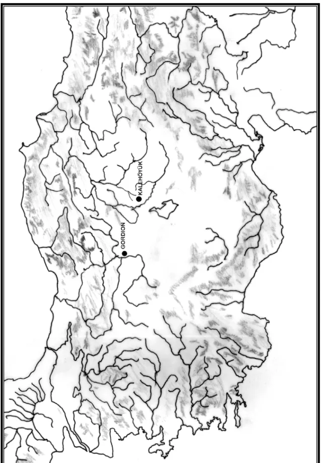
This thesis concerns the ancient subsistence economy in west-central Turkey in the first millennium BC. The study covers two ancient sites Gordion and
Kalehöyük (see Fig1.1). Gordion is located on the right bank of the Sakarya (ancient Sangarius) river in the upper Sakarya basin, whereas Kalehöyük is situated in the bend of the lower Kızılırmak (ancient Halys) river, 150 kilometers east of Gordion. The sites have been selected because of the availability of their environmental and
subsistence data which correlate with each other presumably. Although the sites show different quality and quantity of data, and are set in different zones of Central
Anatolia, their interaction is significant to understand the economic changes and its dynamics in the region at large.
The question motivating this thesis is: How can we observe aspects of the ancient economy in a particular region during the Iron Age? The perplexing nature of the economy caused formulations of other specific questions, the answers to which might be considered, at most, only rough approximations to reality. Some of these further questions can be stated precisely as follows: Does the regional and
environmental interpretation of the study areas help us to understand aspects of the ancient economy? Can we gain an insight into past land use potential observing the present environments of the sites? Do the archaeozoological and archaeobotanical remains provide any statements on the agricultural system of the sites? How can we set Gordion and Kalehöyük in a regional economic perspective? and why is their integration significant?
Multi-disciplinary research and cooperation among specialists are critical to collect and incorporate environmental data to archaeological findings.The contribution of environmental data to an understanding of cultural history in a specific site or regional context can not be overemphasized. Therefore, the limitations of the available evidence related to the regional environment of the study areas will be discussed in general.
In the concluding chapter of this thesis, an attempt will be made to synthesize answers to these questions, by pulling together all lines of environmental and
subsistence data from excavations and surveys. Thus, the information taken from the multi-disciplinary researches, based on the stratigraphic sequence of Gordion and Kalehöyük aims to provide a framework for an examination of the ancient economy. The “Economy” is a term used to describe a system for the management of resources and the production and maintenance of goods: it reveals variation from one society to another through time. In this respect, Gordion was chosen as a case study in its regional, environmental and historical context to reveal economic changes from one phase to another. Although, there is a deficiency of archaeological and historical evidence about the Phrygians' cultural, social and political life, the limited amount of data obtained from several sources will be used to understand the economy of both Gordion and Kalehöyük under the rule of the Phrygian state.
Methodology
This thesis is an attempt to use environmental data, to enhance archaeological materials, and to generate new questions for long-term interdisciplinary researches.
It is divided in five chapters. Following the introduction, chapter 2 provides information about the geographical and historical background of Central Anatolia, including general considerations on the exchange economy.
Chapter three concerns Gordion, first in the light of its environmental setting covering the land use information and geomorphological studies. Second, the
archaeological evidence obtained from buildings, the pottery, archaeozoological and archaeobotanical remains are summarized following the stratigraphic sequence of the site. In addition, all the data are correlated by focusing on the subsistence economy of Gordion. Finally, the ethnoarchaeological data concerning the contemporary economy is used to interpret, in part, the ancient economy of the site.
The fourth chapter covers Kalehöyük and follows a similar plan as that for Gordion, in so far as data allow. At first, the site is observed with its surroundings in the regional context of the Middle Kızılırmak basin. Later, the accessible evidence from architecture, pottery and faunal remains are reviewed. Kalehöyük, similar to Gordion, reveals a continous settlement starting from the Early Bronze Age through the Early Iron Age and Phrygian periods.The stratified study of its faunal remains from the Iron Age levels is significant in comparison to Gordion.
In chapter five, the data relevant to the questions mentioned in the introduction are reviewed and brought together to present an overview of the ancient subsistence economy.
CHAPTER 2: GEOGRAPHICAL AND HISTORICAL BACKGROUND
In this chapter, first, an attempt is given to describe the topography of Central Anatolia. Secondly, Gordion and Kalehöyük are set in their regional contexts, the upper Sakarya basin and the middle Kızılırmak basin, since visualizing natural features of the regions helps to recognize aspects of the economy, communication lines and settlement choices.Thirdly, a broad outline of settlement history, settlement system and communication networks in the Iron Age is given.
2.1 Geographical Setting
2.1.1 Central Anatolia
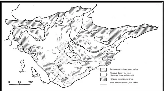
The study areas are located in west-central Turkey in the region of Central Anatolia, which is the second largest region of the country covering an area of 151,000 km² (19% of Turkey) (see fig 2.1). The region is surrounded by various high and low mountains, high plateaus, plains and valleys. It is roughly divided into four zones: the upper Sakarya basin in the west, the middle Kızılırmak basin in the north, the upper Kızılırmak basin stretching towards the east of the region, and the Konya plain in the south. The upper Kızılırmak river basin is the most mountainous area of the region. The mountains (Kızıl Dağ-3,025, Yıldız 2,552m and Çengelli Dağı-2,596m) extend parallel to each other in south-west and north-east directions, and they are seperated by the Kızılırmak river forming a deep valley between them. The fourth zone, the Konya plain covers the Tuz gölü ( the Salt Lake) basin and other river-basins. The general altitude of the region varies between 700 and 1,500 meters above
sea level. The differentation in altitude causes climatic fluctations in different zones. The water sources of the region are mainly the Sakarya and Kızılırmak rivers, which both flow into the Black Sea. The main lake of the region is the landlocked Tuz Gölü. It covers around 400 km², and is surrounded by plateaus and flat alluvial areas.
2.1.2 The Upper Sakarya Basin
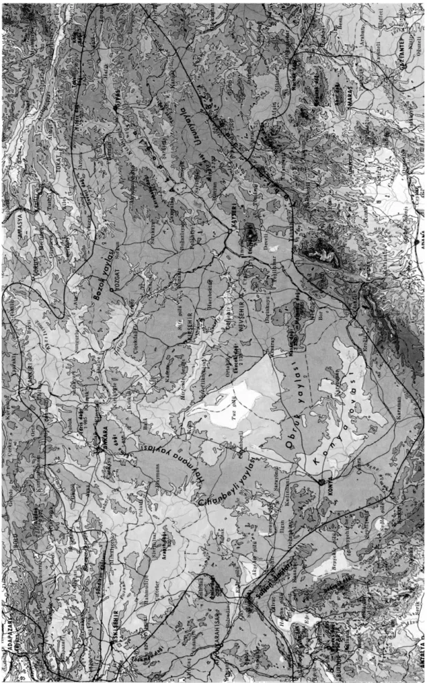
The upper Sakarya basin in the region of Central Anatolia may be divided into six areas: The Eskişehir plain, Yazılıkaya plateau (plateau=yayla), Sakarya plain, Ankara plain, and the Cihanbeyli and Haymana plateaus (see Fig 2.2). In the west, Türkmen Dağı-1,829m (Yazılıkaya plateau), in the south, the Emir (2,241m) and Sultan mountains, in the east, the Cihanbeyli and Haymana plateaus, and in the north, the Sündiken (1,170m) and İdris mountains (1,985m) border the region. In order to see the whole area with its natural borders and communication lines, the Sakarya river basin is set into a circle 120 km in diameter on fig 2.21. The area extending from the
mountains and plateaus forms a vast triangular plain surrounded with highlands and with the Sivrihisar mountains in the center. The plains formed of neogene lake sediments and river deposited alluvium, are known as the Eskişehir, Sakarya and Ankara plains.The altitude of the plains vary between 700m and 900m.
A circle of 60 km in radius is drawn inside the former in order to illustrate the interaction of Gordion with its local environments. The highlands, and the lowlands lying along the rivers and their tributaries shape the physical character of the region. The "catchment analysis" of ClaudioVita-Finzi is used here to understand the time-
1 The irregular line in the figure draws the borders of the Upper Sakarya Basin separating it from the
other geographical zones of Central Anatolia. On the map are also indicated the known Phrygian sites and rock-sanctuaries
Fig 2.2
distance factors in the movements of the inhabitants of Gordion and illustrates access to natural sources2. The radius of the catchment is derived from studies of modern
mobile economies, where short-range transhumance movements may cover a distance of up to 50-60 km, and the long ones require extended travels.3 Gordion is located
2 The catchement analysis deals with the points and areas of origin of all the various contents of
archaeological sites; (Vita-Finzi 1978:25-26) the concept of catchment originated by analogy with the area drained by a river or with the zones from which schools are intended to draw their pupils
almost in the center of the Upper Sakarya basin, and transhumance might have been practiced in the area of 60 km in radius as it is practiced today. In the west and south-west of the area, the Sivrihisar mountain ranges (lying towards Pessinus), in the south, the Günyüzü mountain range (ancient Dindymos), in the east, the Haymana plateau, and in the north, the surroundings of Ayaş and Beypazarı provide pasture lands for the flocks of the lowland inhabitants.
The economy of the Sakarya basin has depended throughout its history on agriculture. The intensively cultivated lands in this basin have been built up through several millennia from the silt deposited by the Porsuk, Sakarya and Ankara rivers. The arable lands are chiefly suited for cereal crops, and the remainder for animal grazing.
The Porsuk, Sakarya and Ankara rivers and their tributaries bound each plain and act as natural communication lines between them. This helps to visualize the transhumance lines, migration routes and the networks of the Iron Age inhabitants. As it is evident on fig 2.1, the roads following the river courses connect Gordion easily to all directions. Ancient people might have used more or less the same networks since prehistoric times.4
2.1.3 The Middle Kızılırmak Basin
The Middle Kızılırmak basin covering the bend of the river extends from Çankırı (in the north) towards the Taurus mountains. The volcanic mountain ranges (Erciyes Dağı-3,917m and Hasan Dağı-3,268m) and high plateaus stretch along its southern border. The altitude of the plains in the bend of the Kızılırmak river ranges
between 1,000 and 1,200 meters and the low mountains scattered in the bend culminate at over 1,500m.
Kalehöyük is also set in a circle of 60 km in radius (see Fig 2.3).
Transhumance movements might have occured between the highlands and lowlands of the area. As is shown on figure 2.3, the site is located in the lower bend of the Kızılırmak river which is the dominant feature of the region. The bend can be considered as the natural border with the Upper Sakarya basin. The Kızılırmak river has a very important function in shaping the region like the Sakarya river. It drains the region with its joined tributaries. It springs from mount Kızıldağ at the north-eastern border of Central Anatolia (110 km south of Giresun), flows through Sivas, and then continues towards Kayseri. It flows in a northward direction 25 km to the west of Kalehöyük
It deposits its sediments along floodplains, and forms lands available for cultivation. Since, it has many tributaries, most of them form routes for travel,
transport and trade. In addition, since ancient times, most of the settlements have been placed close to its tributaries which flow through them and supply water to the region The natural communication lines and defensive position of the high lands set this river basin in a very important strategic location between Europe and Asia, and the Black Sea and Mediterranean coasts. Moreover, it has remained as a very good source of clay and minerals since prehistoric times.
Fig 2.3
2.1.4 Present Climate and Vegetation
In Central Anatolia, a continental climate prevails with long hot summers and cold rainy winters. The differences in the altitudes of the plains, plateaus and
mountains create different quantities of annual rainfalls which vary between 160-480 mm.5 The indicator for this type of climate in inner Central Anatolia is the “Irano-Turanian” plant cover, dominated by varied treeless steppe vegetation. The typical Central Anatolian steppe is mostly covered by Stipa-Bromus steppe (grass steppe), and the areas under the impact of intensive grazing are covered by Artemisia steppe, which is rich in thorns (see Fig 2.4).6
Zohary defined inner Central Anatolian vegetation as Xero-Euxinian (dry) as a result of low average precipitation.7 The Xero-Euxinian forest cover in the north of Central Anatolia is largely a combination of oak and pine: Pinus nigra (Black pine-Karaçam), Quercus cerris (Oak), Juniperus excelsa (Grecian Juniper), Quercus
pubescens, Pyrus elaeagrifolia, Pyrus syrica, Berberis, Crateagus laciniata and Crateagus monogyna (one-seed haw-thorn).8 The remnants of this forest type are to be found in the interior of the region at higher altitudes. However, the low rainfall and wide temperature variation of the continental climate do not favor growth.9 Finally, arable farming and animal grazing also reduce the vegetation cover (particularly oak and pine).10
5 Zohary 1973, 178
6 Ertuğ 1997, 13. The vegetation map shows the areas of Artemisia steppe, feather-grass steppe, open
woods and bushes (steppe woods)
7 Zohary 1973, 175, defines Xero-Euxinian as a transitional geographic region between the
Euro-Siberian and the Irano-Turanian because of its Irano-Turanian steppe covered with Euro-Euro-Siberian trees and shrubs
8 Van Zeist 1991, 158 9 Wilcox 1992, 2 10 Bender 1975, 94
Fig 2.4 Vegetation map of Central Anatolia (from Ertuğ 1997) Legends : 1 Potential area of primary Artemisia steppe
2 Potential area of feather grass steppe and drawf bushy steppe formations 3 Potential area of open woods and bushes (‘steppe woods’)
Soil
Soil can be considered as the main factor for the organisms to survive. In Turkey, there are several type of soils, and climate is one of the dominant factors in the formation of soil series.11
The soil categories reflect the degree of erosion in the environment (on farmland, woodland and pastureland). Erosion and soil degradation are caused by human and natural factors.12 Especially, when the surface of the soil held together by the roots of grass is cut and torn up during the cultivation of the land, and damaged by
11 Doğan 1998, 1
12 Doğan 1998, 6-7. Human factors are as follows; land use: Farmers use pasture and woodland for
agricultural purposes instead of increasing the productivity of soil. Dry cultivation: it makes the soil more sensitive to erosion.Destruction of forests: It causes water erosion. Overgrazing: It highly
increases erosion and degrades soil fertility. Natural factors are as follows; climate, rain, heat, wind and slope of the land
the hooves of the grazing domesticated animals, it loosens and becomes highly erodible.13 This is evident in the Sakarya river basin at Gordion, where 4 meters of sediments aggraded along the river in the last 2000 years as a result of extensive erosion, and it highly influenced the environmental situation in the vicinity of the site (see chapter 3). Furthermore, soil degeneration and devegetation favour acidic
conditions, which create a handicap for agriculture.14 Therefore, the economy is directly affected by this situation, both cereal agriculture and livestock raising.
The typical soils for Central Anatolia are brown, chestnut brown and alluvial. Brown soils occur in the areas where annual rainfall is below 400 mm.15 Brown soil is mostly alkaline, sometimes neutral or slightly acidic.16 Chestnut coloured soil, with
less lime content occurs at over 1000m above sea level in areas covered by forest steppe. The alluvial soil found in the old lake basins and old river beds, is favorable for plant cultivation.17
2.2 Historical Background
2.2.1 Settlement History
Concerning the settlement history of Anatolia, the transition from the end of the Late Bronze to the Early Iron Age is still problematic. At the end of the late
13 Butzer 1982, 127
14 Butzer 1982, 127; (Bender 1975, 97) Bender discusses how wild plants adapt to naturally disturbed
habitats as a crop weed complex. The wild cereals specifically prefer open soils on basaltic and limestone formations
15 Atalay 1994, 362-363 16 Zohary 1973, 482
17 Türkiye Geliştirilmiş Toprak Haritası Yenileme Etüdleri Projesi Toprak Su Genel Müdürlüğü
Bronze Age, considering the political, religious, cultural and social lives of the Anatolian people, many striking changes occur. First of all, an important ruling power, the Hittite empire, collapses and many cities are destroyed. The exact reason of its fall has not been found out. One of the reasons might be a political conflict among the rulers or the people under rule. According to Mellink, the Hittites fought against the Anatolian chieftains who tried to gain their own economic and political independence, or new groups immigrating to Anatolia.18
In the beginning of the Early Iron Age, foreign intruders immigrate from the Balkans, Caucasus, Near East, Greece, and Aegean and Mediterranean islands. These immigration cycles might have continued since prehistoric times. The newcomers mix with the native Anatolians and the native people, new intruders and tribes emerge under the name of Phrygians, Armenians, Lycians, Carians, Urartians, Lydians, Mysians, Bithynians, Paphlagonians, Psidians, Isaurians and Lycaonians.19
At this time, the Phrygians appear in the history of Anatolia. We do not know exactly to how many cycles of immigrations they contributed or which routes they followed and with whom they mixed. In addition, it is not clear why they came and how they arrived in Anatolia, by land or sea? There is not much meaningful evidence also about the existence of the Phrygians at Gordion until the 9th century BC. The Phrygians' origin and their arrival at Gordion still are a subject of discussion among scholars.20 However, there is a strong belief that the Phrygians immigrated to Anatolia
18 Mellink 1991, 621
19 Mellink 1991, 619
20 Herodotus. VII.73, 385, wrote about the Phrygians referring to them as Macedonians, according to
him, the Briges or Bryges when they were in Europe. However, they changed their name to Phrygians, when they arrived to Anatolia. He, also identified them as a horse-rearing military aristocracy; Strabo; (Strabo VII.3.21), called the Phrygians Thracian colonists, and Xanthus of Lydia mentioned their arrival in Anatolia from Europe and from the west of the Black Sea; (Mellink 1975, 420), according to Assyrian sources, they were known as Mushki people from the east; (Ramsay 1962, 34), believes that the Phrygians came from Troy, and they were originally the people of the coast and were forced to immigrate to Central Anatolia by the barbarian Thracian tribes
from south-east Europe, since the Phrygian language which is considered as the strongest evidence, has significant similarities with the Balkan languages.21
Their political-cultural life comes into existence after the 9th century BC, since there is no political unity among the tribal societies in the Early Iron Age.22 During the Early Phrygian period (950 ?-720? B.C.), Gordion becomes the capital city of the Phrygians at the end of which the Citadel Mound is destroyed.23 This event has not been explained satisfactorily yet, and the date of the Early Phrygian destruction is still problematic and the object of debate among scholars.24 According to the Assyrian sources, the west part of Anatolia, covering the whole Kızılırmak basin is occupied by the Phrygians.25 Midas of Phrygia is reported to have been in coalition with Psiri of
Charchemish against the Assyrian empire.26 This illustrates political relations between the Phrygians and the southeastern territories.27 However, in the 7th century BC the region to the south-east of the Kızılırmak river (most of Cappadocia) comes under the rule of the Assyrians, and later at the end of the 7th century B.C, the Median Empire expands its control up to the the border of the Kızılırmak river in west-central Anatolia.28 The Phrygians gradually start to lose their power and, consequently, the Lydians establish their rule at the capital city of Gordion and extend to the west of the Kızılırmak river. Following the sack of Sardis in 547 BC, the Achaemenid Empire dominates the region until the beginning of the Hellenistic period.
21 Mallory 1990, 32, mentions that the Phrygian language is very close to Thracian and Illyrian, two
main Indo-European languages of the Balkans, particulary, to the Thracian language. However, both Thracian and Illyrian have scant linguistic remains. The other similarities are the tumulus burials and the handmade burnished ware pottery.
22 Yakar 2000, 54
23 Voigt and Henrickson 2000, 51
24 Voigt and Henrickson 2000, 52; however, (Gürsan-Salzmann, pers.comm) according to the new C14
analysis, Mary Voigt has recently announced that the exact date of the destruction level is 835 BC.
25 Mellink 1991, 622
26 Sams 1993, 192-193. Midas is known as Mita of Mushki (Mushki-Phrygians) by the Assyrians 27 Hawkins 1982, 417-422
2.2.2 Settlement system
Since the researches and surveys regarding the Iron Age period are still preliminary, it is very difficult to discuss the settlement system during this period. However, in the light of the surveys and excavations of Hattuşa, Gordion and Kalehöyük excavation teams, a few assumptions can be made.
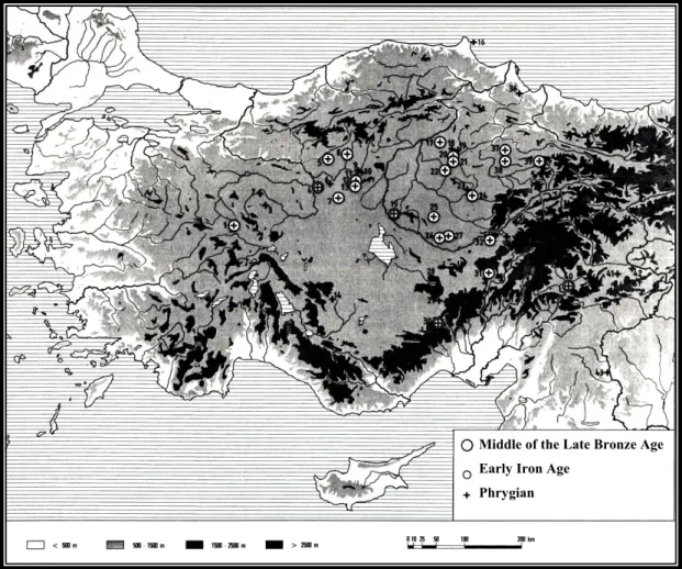
A remarkable research has been done by the Boğazköy-Hattuşa excavations. Fourty-three settlements with Phrygian period ceramics have been identified.29 In Fig 2.5, the middle of the Late Bronze Age (Old Hittite period-1500 BC), Early Iron Age,
Fig 2.5 Adapted from Bossert 2000
29 Bossert 2000, 5
Middle of the Late Bronze Age Early Iron Age
and Middle Iron Age (Phrygian=Late Hittite period) settlements are illustrated. These sites are located in the Upper Sakarya basin, middle Black Sea coast, Middle and Upper Kızılırmak basin, Konya plain and Southeast Anatolia (see Table 2.1 ). Twenty-three of them are dated to the middle of the Late Bronze Age and four of them are dated both to the middle of the Late Bronze and Early Iron Age.The survey results reveal a remarkable feature: although more than half of the sites show evidence for both the MLBA and Phrygian period, only 4 actually show continuity through the EIA. The appearance of few sites concerning the Early Iron Age might suggest that there are no satisfactory explanations for the characteristics of the EIA.
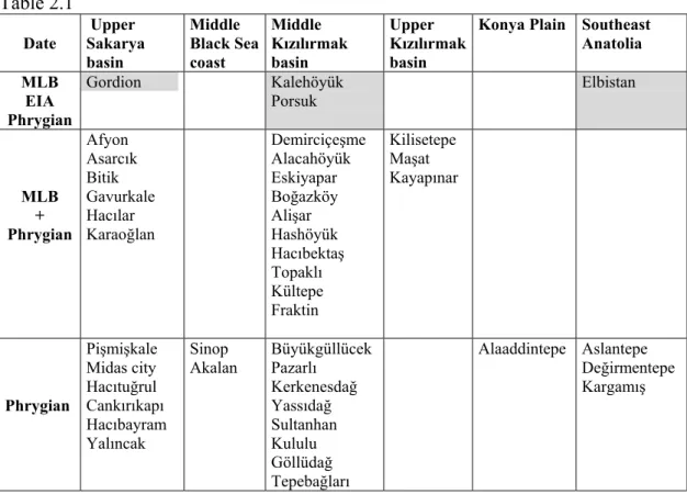
Table 2.1
Date Upper Sakarya basin Middle Black Sea coast Middle Kızılırmak basin Upper Kızılırmak basin
Konya Plain Southeast Anatolia MLB EIA Phrygian Gordion Kalehöyük Porsuk Elbistan MLB + Phrygian Afyon Asarcık Bitik Gavurkale Hacılar Karaoğlan Demirciçeşme Alacahöyük Eskiyapar Boğazköy Alişar Hashöyük Hacıbektaş Topaklı Kültepe Fraktin Kilisetepe Maşat Kayapınar Phrygian Pişmişkale Midas city Hacıtuğrul Cankırıkapı Hacıbayram Yalıncak Sinop
Akalan Büyükgüllücek Pazarlı Kerkenesdağ Yassıdağ Sultanhan Kululu Göllüdağ Tepebağları Alaaddintepe Aslantepe Değirmentepe Kargamış
Another regional survey covering 22 mounds (see Table 2.2 and Fig 2.6) within a 30 km radius of Kalehöyük was done by Mikami and Omura in 1986.30 The survey results points out that the occupation history of the area starts from the Early Bronze Age. Pottery sherds collected from the sites show evidence of LBA and Phrygian period habitations, but do not indicate any Early Iron Age occupancy.
Table 2.2 The names of the mounds that are surveyed in 1986 NO NAME 1 Darıözü Höyük 2 Kağnıcak Höyük 3 Degirmenözü 4 Adısız Höyük 5 Kızlar Höyük 6 İsahocalı Höyük 7 Yeniyapan Höyük 8 Çayözü Höyük 9 Ömerhacılı Höyük 10 Tepeköy Höyük 11 Sıdıklı Ortaoba 12 Akpınar 13 Faklı Höyük 14 Yassıhöyük 15 Höyüklütarla 16 Höyüklü 17 Doydunun Höyük 18 Kuru Höyük 19 Taşlık Höyük 20 Höyüklü Tarla 21 Tek Höyük 22 Hanyeri Höyük
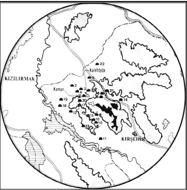
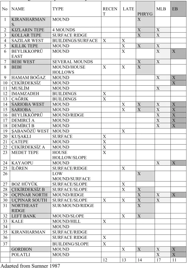
In the Upper Sakarya basin, a regional survey was done by Sumner in the vicinity of Gordion in 1987. 39 sites were identified in an area of 400 km² (see Fig 2.7). 31 This survey also revealed that most of the Early Bronze Age sites showed continuous occupancy till the end of the middle of the Late Bronze Age. The number of the settlements increases in the middle of the Late Bronze Age period, however, the number slightly decreases in Phrygian times and remains stable in later periods. In addition to that, only nine of seventeen MLB mounds were settled in the Phrygian period. The survey results do not specifically mention about a gap between MLB and EIA. However, they show a change in settlement patterns at the end of the middle of
30 Mikami and Omura, 1987 31 Sumner 1992
the Late Bronze Age period, and might suggest abandonment as a result of environmental deterioration, disease, or catastrophe (see Table 2.3).
Fig 2.7 Adapted from Sumner 1987
Mounds Tumuli Gordion
Table 2.3 Regional survey in the vicinity of Gordion
No NAME TYPE RECEN
T LATE PHRYG MLB EB 1 KIRANHARMAN S. MOUND X
2 KIZLARIN TEPE 4 MOUNDS X X
3 KOLLAR TEPE SURFACE RIDGE X X
4 SAZILAR WEST BUILDINGS/SURFACE X X
5 KILLIK TEPE MOUND X X X
6 BEYLIKKOPRÜ
EAST MOUND X X X
7 BEBI WEST SEVERAL MOUNDS X X
8 BEBI MOUND/HOUSE
HOLLOWS X X X
9 HAMAM BOĞAZ MOUND X X
10 ÇEKİRDEKSİZ MOUND X
11 MUSLİM MOUND X
12 IMAMZADEH BUILDINGS X
13 ÇAĞRIK BUILDINGS X
14 SARIOBA WEST MOUND X X X X
15 SARIOBA MOUND X X X X
16 BEYLİKKÖPRÜ MOUND/RIDGE X X
17 DEMIRCİ A MOUND X X
18 DEMİRCİ B MOUND X X
19 ŞABANÖZÜ WEST MOUND X
20 KUŞAKLI SURFACE X
21 ÇATEPE MOUND X
22 ÇEKİRDEKSİZ A MOUND X
23 MEDET TEPE HOUSE
HOLLOW/SLOPE X 24 KAYAOPU MOUND X X 25 İLÖREN SURFACE/RIDGE X 26 LOW MOUND/SURFACE X
27 BOZ HÜYÜK SURFACE/SLOPE X
28 ÇEKİRDEKSİZ B SURFACE/SLOPE X X
29 OÇPINAR NORTH MOUND/RIDGE X X X
30 UÇPINAR SOUTH SURFACE/SLOPE X X X X
31 NORTHEAST
RIDGE SUR/MOUND/RIDGE X
32 LEFT BANK MOUND/SLOPE X X
33 KALE MOUND/HILL X 34 MOUND 35 KIRANHARMAN SURFACE/RIDGE 36 SURFACE RIDGE X 37 BUILDING/SLOPE X GORDION MOUND X X X X POLATLI MOUND X X 12 13 14 17 11
After the destruction of the main cities at the end of the Late Bronze Age, the later settlements are smaller relative to the previous periods. The deficiency of archaeological evidence creates a handicap to understand the changes in the cultural, social and economic lives of the Early Iron Age inhabitants. Yet, the gap between the middle of the Late Bronze and Early Iron Age might reveal that there is an unstable settlement system in Anatolia as a result of destructions, conflicts and migrations, or that we simply do not recognize EIA material everywhere.
The settlements pattern of the Middle Iron Age is known much better. Most probably the Upper Sakarya basin, where the capital city Gordion is located, is densely occupied in the Early Phrygian period. There might have been many small towns governed by the “Phrygian State”. Since the Phrygians have a centralized goverment system, they might have also selected some other cities as centers to rule the small villages. Among the latter, we can count Ankara and Hattuşa. Most of the cities of this period are also fortified like Gordion. The Iron Age surveys of Tuba Ökse in the upper Kızılırmak basin indicate that many Phrygian settlements have fortresses (hillforts).32
In addition, the Sakarya and Ankara plains are noteworthy to point out the great numbers of burial mounds33. Elite people are buried in them with their precious belongings.34
32 Ökse 1998, 331; Some of the well known settlements that have Phrygian hillforts or fortification
walls are as follows; Mellink 1974, HacıTuğrul-Karahöyük; Mellink 1982, Ankara; Stephen 1994, Gavurkalesi; Omura 1998, Kaman-Kalehöyük; Summers 1999, 177, Kerkenes Dağ; Seeher 1995, Boğazköy-Hattuşa
33 Not all of the mounds are dated to the Early Phrygian period and most of them are not excavated. 34 The carving of the rock sanctuaries and building up the burial mounds needed large amount of labour
and artistic work. Some of the timbers such as boxwood used in making the wooden tables in the tumuli was brought from afar. They might reflect partly the development of the power and economic growth of Phrygia
The open air sanctuaries of the Phrygians, likely to be indicators of their pastoral life, are found in the highlands and close to water springs.35 In addition, Roller states that the cult monuments define the boundary zones of the Phrygians' where the highlands and mountains act as the natural limits of their villages.i Emilie Haspels discovered several rock sanctuaries and tombs in the "Phrygian Highlands" which lie between four towns Eskişehir (ancient Dorylaeum), Kütahya (ancient Kotiaion), Afyonkarahisar (Byzantine Akroenos), and Seyitgazi (ancient Nacolea)36. Similar ones have also been recovered to the northeast of Pessinus.37 However, like many archaeological sites, rock monuments might have been also buried under the sediments of the Sakarya river. Therefore, there is not much information about the Phrygians' religious activities.
The discovery of new Iron Age settlements with Phrygian occupation levels might illuminate the Phrygians' regional settlement patterns and their extended borders. The distribution of the Phrygian sites and Phrygian inscriptions38 (see Fig 2.8)may illustrate cultic and socio-political connections.39
35 There is not a clear identification of open air sanctuaries. They are known as step altars and rock-cut
ritual basins found at highlands. Their exact dates are not known and they might have been used even earlier than the Phrygian period
36 Roller 1999, 102
37 Haspels 1971, 20
38 Devreker and Vermeulen 1992, 110 38 Brixhe and Lejeune 1984
39 Summers 1994, 241; the extended borders of Phrygia are not known, however, the evidence of the
Phrygians' cult practices might give some clue about it; according to Roller (Roller 1999, 64), evidence of their cult practices is seen in all Central Anatolia. It even spreads to Afyon and Kütahya in West Anatolia, to the Elmalı plain-north of Lycia in the south, to the district around Bolu (ancient Bithynia) in the north and to the Marmara Sea in the north-west. The spread of the Phrygian Mother goddess as a cult was also evident in the region beyond the Kızılırmak River (ancient Halys) towards Kerkenes Dağ in the East, and the region of ancient Tyana, near modern Niğde, in the southeast of Central Anatolia; (Summers and Summers 1999, 177), identify Kerkenes with the ancient city of Pteria which had an inter-regional position controlling major routes from the Black Sea to North Syria and the
Mediterranean passing through the Taurus Mountains inter-regional position controlling major routes from the Black Sea to North Syria and the Mediterranean passing through the Taurus Mountains
1 Midas City 2 Kümbet 3 Arslankaya 4 Maltaş 5 Fındık 6 Çepni 7 Germanos 8 Gerede 9 Fıranlar 10 Gordion 11 Karahöyük 12 Höyük 13 Kalehisar 14 Pazarlı 15 Hattuşa 16 Tyana 17 Porsuk
Fig 2.8 The finding spots of the Phrygian Inscriptions (from Brixhe and Lejeune 1984)
2.2.3 Communication Networks
Since the exchange economy concerns surplus from the subsistence economy, the imports are mentioned within the network system.
The physical features of Turkey permit many connecting passages throughout the country. The sea routes along the Mediterranean, Aegean and Black Sea coasts find land links to the interior parts of Central Anatolia through several ports, and these links intersect the routes proceeding from Northeast, East and Southeast of Turkey.
The communication networks of the Iron Age, have not much changed since the obsidian trade routes of the Neolithic period. The natural passageways remain the same. However, their control by the rulers of the territories might effect independent transitions. In reference to the new movements of people coming to Anatolia from overseas, other mainlands and continents, or changing their permanent residence within the borders of the country, there is a need to consider both the sea and land routes mentioned above.
The Early Iron Age is a time when inland and overseas communications are reduced strikingly relative to the Middle of the Late Bronze Age. Particularly, the collapse of the Hittite empire might have influenced the communication lines with the coastal lands, since the Hittites kept control of the main inland networks.
Therefore, the material culture of the Early Iron Age settlements does not show much cultural, political and social contacts between the peoples of the varied
Anatolian regions. Small groups of people of different origin acting independently might have moved to different parts of the country. 40 This period might be considered as the time of new immigration cycles and emergence of people. However, the dark hand made ware of sub-phase 7B at Gordion reveals parallels in LH IIIC Mycenean Greece, Troy VIIb, Thrace and Kalehöyük. The wide spread of this pottery might point out some cultural contacts among the Early Iron Age people.41
Gordion has a very important strategic location on the path of the main inland routes. With regard to trade, it was on the crossroads since prehistoric times. While the Hittites were dominating Central Anatolia during the Late Bronze age, the site was a small political unit under their control.42 During the Early Phrygian period Gordion lived its most prosperous times. The large megarons with many remains of wealth and luxury belong to the elite of the city.43 The Phrygians, as might be expected from this period, start to produce and exchange many striking iron and bronze objects which are significant as a sign of international contact between west, south-west and east.44 The
40 Bouzek 1997, 31
41 The rectilinear houses found at Gordion might suggest a contact with west. One-room houses
rectangular in plan are also found at phase IId of Kalehöyük. Omura thinks that it is a western influence, since it shows similarity with Gordion
42 Voigt 1994, 276. At this time, with its mass production of pottery, Gordion had a centralized state
economy. Gordion's location was significant concerning the metal trade networks
43 De Vries 1980, 34
44 Yener and Özbal 1994, 379. They comment that military and domestic items were found among the
metal objects; shields, swords, cauldrons, ampholus bowls, belts, pitchers, fibulae, pendants, and rings. These objects which were found in the tumuli correspond to the Urartian ones, (De Vries 1980:33),
contacts with mainland Greece and the islands in the west increase as a result of Ionian trade and colonization.45 The Phrygians might have used the south-western road via Afyon-Salihli to reach Smyrna, or Afyon-Salihli-Selçuk to Ephesus and Miletus. In attempting to trace the lines of communication with the south-east regions, we might consider some special products as evidence. The inlaid wooden furniture with figured ivory plaques, relief orthostates, and ivory horse trappings found on the City Mound suggest the influence of Neo-Hittite city states and North Syria46. The connection of Gordion to the Mediterranean coast and south-east Anatolia might be established via the Haymana plateau- Konya plain (Iconium)- Niğde (Tyana) road through the Cilician Gates, or via the Haymana plateau-Aksaray (Acemhöyük)-Niğde- Elbistan to Kargamış road. The Phrygian ceramics found at Sinop and Samsun on the Black Sea coast suggest a northern road on the plateau via Ankara.
The Phrygian inscription on the black stone of Tyana found near Niğde, is an important indicator of south and south-eastern relations.47 Moreover, the Phrygian type of tumuli recovered in the Uşak-Güre and Dinar-Afyon area, in the plain of Elmalı in Bayındır, Karaburun and Kızılbel in north Lycia, and in the region of Tyana might indicate the cultural-political extension of the Phrygians in later periods.48
The sixth century, under Lydian control, witnesses an increase in the variety of Greek and Lydian pottery and Phrygian exports.49 Besides, the Ivory and glass
were also found on mainland Greece; Muscarella (Muscarella 1992:338) also states that in the west, a lot of Phrygian fibulae from the 8th century were found in Greek sanctuaries, Lindos, Samos, Olympia,
the Argive Heraion; belts at Chios, Ephesus, Bayraklı and Samos;omphalos bowls and bowls at Samos, Olympia, Perachora and the Argive Heraion
45 Austin and Vidal-Naquet 1977, 49; overpopulation occured in mainland Greece.
46 De Vries 1990, 390; Sams thinks that, (Sams 1979: 46), this contact could be the result of political
and commercial relationships
47 Mellink 1991, 625 48 Mellink 1991, 632
49 This might suggest much closer contact with the west; ( Roebuck 1959, 48-9), as well, large
quantities of Lydian wares, little master cups, Attic pottery and East Greek pottery were found at Gordion. In the sixth century, the Phrygians were also exporting slaves. In Miletus, Phrygian slaves were known to grind barley. The Phrygian economy was partly based on selling the slaves. In the ancient sources, Phrygia was known as a source for slaves
artifacts found in the excavations at Gordion suggest that these kind of imports came to Gordion by the great overland trade road from the east.50 Herodotus, mentions the Persian Royal Road as leading from Lydian Sardis in the West through the Cilician Gates, and then reaching Susa near the Persian Gulf. This implies that the location of Gordion might have been use as a strategic station on the Royal Road. A post-Phrygian road found near the tumuli might support this suggestion.51
2.3 Summary
This chapter attempts to define a regional framework for the study areas outlining the physical features of Central Anatolia. When the sites are set in their regional settings, the differences and similarities become apparent. With the exception of differences in the regional altitudes, precipitation and closeness to the main
streams, the environmental setting of Gordion and Kalehöyük in their regions reveal partial resemblance. The presence of highlands with cultivated plains at lower altitudes with a continental climate suggest a mixed-farming and herding economy. Particularly, the Sakarya and Kızılırmak rivers play important roles in their regional economies.
The settlement history of both the Upper Sakarya and Middle Kızılırmak basins starts later than the Neolithic period. Most frequently one notes continous occupancy until the middle of the Late Bronze Age. However, there is a break in the settlement system of EIA. Many sites do not reveal any occupation of this period. This
50 Young 1963, 348. The increasing evidence of Urartian and Persian products suggests the overland
route between Ionian coast, Central Anatolia and East. For the overland route across Anatolia in the 8th
and 7th centuries BC, see Birmingham’s article (Birmingham 1961, 185-195)
51 Young 1963, 348; Ramsay 1962; (Briant 1996: 390), the royal road was used to transport goods by
could be also a reason of an absence of significant EIA material culture. Yet, the excavations and surveys suggest that the Middle Kızılırmak basin was more densely settled than the upper Sakarya basin. Complex societies such as the Assyrians, Hittites and others inhabited this area during the Bronze Age. Moreover, their interregional communication networks were established through the bend of the Kızılırmak river to all directions of Central Anatolia.
In the Early Phrygian period, the Phrygians formed their state in the Upper Sakarya basin and extended their contacts throughout Central Anatolia. They might have made their settlement choices according to the geographical privileges of the region. In the earlier times of the Phrygian State, their mobile pastoralism was probably more important than the long-range exchanges. This activity might have influenced their interregional contacts and helped to extend their cultural and political borders.
In the Middle Phrygian period, the political power of the Phrygian state became less effective and almost lost, but their cultural and social life possibly remained largely unchanged. The increase in the long-range exchange and its continuity in the Late Phrygian period suggests that the Phrygian economy became more diversified even after the collapse of this state and may indicate that they became less dependent on mobile pastoralism.
CHAPTER 3: GORDION
In this section, the environmental setting of Gordion is observed through the land use analysis and geomorphological studies. The physical features of its
surrounding are explored to make some assumptions about past land use and its economic potential. The geomorphological studies are taken into consideration in understanding the role of the Sakarya river in environmental changes. In addition, the archaeological evidence: architecture, pottery, botanical and faunal remains are analyzed to indicate social and economic changes in relation to the environment. Furthermore, the ethnoarchaeological and ethnohistorical data is used to provide a new perspective on past conditions.
3.1 Environmental Setting
The Site and its Location
The mound called Yassıhöyük, and known as Gordion in ancient sources, is located about 100 km southwest of Ankara and 20 km west of the provincial town of Polatlı in west-central Turkey at about 700 m above sea level.52 As for the climate, with average precipitation of 386.9 mm (1931-1991), winters are cold and rainy and summers are hot and dry.53 Yassıhöyük, which is known as the Citadel Mound, is the
main locus of a large occupation. It culminates 16 meters above the plain and covers an area of 12ha. To the south of the Citadel Mound, is located a small fortified site called Küçük Höyük, whose summit culminates 22m above the plain, and the area between them is known as the Lower Town. The area to the north-west of the Citadel
52 Marsh 1996 53 Doğan 1998, 165
Mound, where the settlement extends over about 72 hectare is called the Outer Town (see Fig 3.1).54 The whole site, including the topographic zones described above, is situated on the right and left banks of the Sakarya (Sangarius ) river.
Its most important tributaries are the Porsuk and Ankara rivers, which connect 3 km north of the mound. The Porsuk river flows from Eskişehir, to the west of Gordion, and the Ankara flows from the capital city of Ankara, to the north-east of Gordion. Pleistocene tectonics, having raised the plateau at the east of the valley, played a great role in shaping the present-day Sakarya valley.55 The sites are scattered along the slopes and ridge-tops of the valley where more than 100 burial mounds or tumuli can be seen at a close distance.56
Vegetation
The wider region of Gordion is treeless today. The only trees and shrubs like the tamarisk (Tamarisk), poplar (populus) and willow (Salix) grow along rivers and watered gardens57, where one sees also minor types like the hawthorn (Crataegus) and
elm. At Mihaliçcik, nearly 40-50 km away from Gordion, at an elevation of about 1000m, there is a pine forest (with an understory of oak and juniper) in the
mountainous zone. Oak and juniper grow starting about 10 km from the site. However, the absence of juniper and oak in the area today cannot be attributed to deforestation during the 1st millennium BC.58
54 Voigt 1997, 1 55 Rosen 1996 56 Voigt 1997, 1 57 Miller 1992
Fig 3.1 Adapted from Sumner 1987
3.1.1 Geomorphological Research
The geomorphological studies help us to understand the conditions of topography, hydrology and climate of the ancient sites during the early human occupation.59 At Gordion, the geomorphological researches were done by Tony Wilkinson, Arlen Miller Rosen and Ben Marsh. They have focused on tracing sedimentary processes of the Sakarya river and changes in settlement patterns in the
landscape of Gordion. Rosen has studied the past land forms examining the geological stratigraphy of the region starting from the Pleistocene period.60 In her surveys, she emphasized that the topograhy of the area at that time was very flat (there were no hills and mountains ) as there was a great salt lake in the region.61 Later, topography started changing in the eastern part of the Sakarya valley, where folding and uplift of the Pleiocene strata formed plains and valleys, thus the basins of the Porsuk and Sakarya rivers were created.62
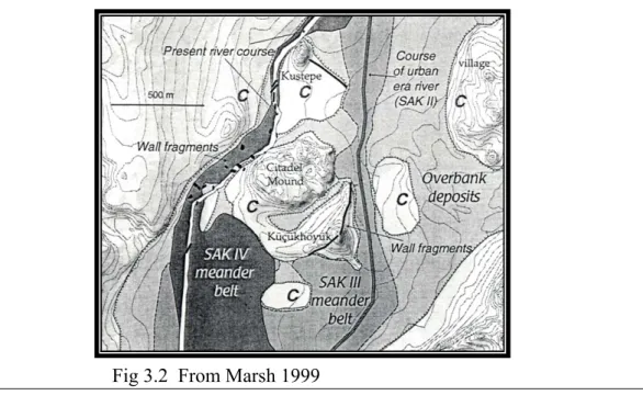
Rivers have a very important role in the evolution of landscape. The Sakarya river springs around Çifteler village, located in the north of the Sultan mountains. It drains about 60, 000 km², and empties in the Black Sea.63 The shift of the Sakarya
river at Gordion was carefully examined by Ben Marsh in five phases (SAK I, II, III, IV,V) (see Fig 3.2). In phase SAK I, soil erosion and sedimentation raised the bed of the river beginning from the end of the Pleistocene period when the glacial meltwater
60 Rosen 1998 61 Rosen 1998 62 Rosen 1998
63 Marsh 1999, 165, Marsh states that the Sakarya river is not navigable. However, in ancient times;
Briant 1996, 392, both the Sakarya and Kızılırmak rivers might have been used for the transportation of goods
from the Taurus mountains moved over the Sakarya plain.64 In phase SAK II, the Sakarya river shifted to the east of the Citadel and lower town, in the middle of the valley. Its altitude was 3m below the present alluvial plain.65 Marsh defines this phase as an early urban period extending from the Bronze Age to 600 B.C. (see Table 3.1).66 In phase SAK III, the Sakarya river was sandy and straight and 6m below the present river, but then it began meandering and carrying alluvium which raised its bed. After 600 BC, during the Middle Phrygian period, it aggraded remarkably and many hectares of the settlement were buried under 3 to 5meters of sediments.67
Table 3.1: Evolution of the Sakarya River at Gordion
Form Onset Origin Location Channel Sedimentation
Sakarya V 1967 Channelization by the Turkish government West of mound; 3-5 m below plain Straight;
20-30m wide Down-cutting at present Sakarya IV 19th century? Shifted course from
aggradation and fan growth West of mound After a major course change Shallow, meandering;ero ding into stone city walls
Meager silty over-bank sediment
Sakarya III Ca. 600 B.C Widespread disturbance of vegetation in watershed
East of mound; eroded out parts of city Meandering, aggrading;sand y, gravel bed 3-5 m of fine grained over-bank sediment
Sakarya II Early urban period; Bronze Age to ca. 600 B.C
Urbanization (and
irrigation?) East of Citadel Mound; plain 3-5 m lower than present Gravelly, straighter and steeper than later forms Continous paleosol on plain; clean channel gravel Sakarya I Pre-settlement Pleistocene pluvial/
glacial flow from beyond present basin; Holocene watershed runoff Transgressed the valley; 4-8 m below present plain Varying 2-m cycles of coarse to fine sand
From Marsh 1999
In phase SAK IV, the meandering movement continued, and finally in phase SAK V, the Sakarya river was artificially channeled.68 The settlement patterns at Gordion changed according to the shifting of the river bed, and the old bed of the river 64 Voigt 1997, 21-3 65 Voigt 1997, 23 66 Marsh 1999, 166 67 Marsh 1999, 168 68 Voigt 1997, 26
formed an alluvial valley of good agricultural land. In the last 2000 years, 4 m of sediment accumulated in the Sakarya Valley. This also indicates that erosion was the main reason for reshaping the present landscape.69
Soil
When the Sakarya alluvial sediments were examined by Tony Wilkinson in 1992, he stated that the soil is mostly grey and greyish brown, and especially that the soil of habitation areas is more grey than in the unhabited ones.70 The distribution of soil types suggests that the west shore of the Sakarya river was not densely settled but mainly used for cultivation purposes.
Also clay analysis of pottery was done by Henrickson and Blackman.71 They emphasized that ancient potters used the clay of the river to make pottery. However, waterlogging and erosion, and extensive alluviation could have buried the clay sources used in antiquity. The clay analysis of the ceramics showed that Late Bronze Age potters used calcareous river clay from the vicinity of Gordion while Early Phrygian potters used the non-calcerous type in their production.72 Besides the clay sources, Phrygian builders used the red fluvial sandstone in the construction of the Terrace building on the city mound.73
The area around Gordion, east of the Sakarya river, is mainly covered with brown soil which is good for dry farming, but, it is not used for farming today, because it is highly degraded. The western shore of the Sakarya is covered with alluvial soil. This type is very good for agriculture, as it has rich deposits of minerals
69 Voigt 1996 70 Wilkinson 1992
71 Henrickson and Blackman 1996, 79 72 Henrickson 1996, 79
carried by the river.74 Today, the agricultural fields are on the west bank of the river, while, the habitation areas are located on the east.
3.1.2 Land Distribution Analysis
This analysis consider the present day land morphology, and it is linked closely to the results of surveys and geomorphological studies. Regional
topographical75 and soil maps (see Fig 3.3)76 are used to interpret the physical features of the land . A contour map prepared within a circle of 10 kilometers in radius is used to illustrate Gordion in its present environmental context and to make some
assumptions about its setting in the past (see Fig 3.4).77 Particularly, it aims to illustrate the type of exploitation of the area by the inhabitants of Gordion as a
function of the relative distance and abundance of land forms, indicative of economic potential.
As it is shown on the maps, the Sakarya and Porsuk rivers are the main rivers, and many intermittent streams join their river valleys. The soil map demonstrates that the arable areas are found mostly in the valley bottom, lying along the Sakarya and Porsuk rivers. The average altitude of the area changes between 700 and 1000 meters. The areas above 800 meters are partly used for cultivation.
The regional survey done by Sumner indicates that most of the sites and the tumuli are found to the east of the Sakarya river below 850 meters where the soil has lower agricultural potential (see Fig 2.7).78 However, the soil in that area might have
74 1972, Toprak Su Genel Müdürlüğü., Ankara İli Toprak Kaynağı Envanter Raporu
75 The topographical map of 1: 100.000 scale has been taken from the Harita Genel Komutanlığı. 76 The soil map of 1: 100.000 scale has been taken from the Institution of Agricultural and Village
Affairs.
77 Jarman and et al. 1982, 38; The maps are prepared using the "site catchment analysis" of Claudio
Vita-Finzi.
Fig 3.3
Arable areas Meadows Hilly Zones Grazing areas
been available for cultivation in the Phrygian period, since the course of the Sakarya river lay to the east of the Citadel and lower town, in the middle of the valley. On the contrary, the upper terraces of the west bank of the river are highly cultivated (see Fig 3.3), and less settled. Besides, the immediate banks of the Porsuk and Sakarya rivers are not arable, since they are highly eroded as a result of deforestation, grazing, tectonic movements and plowing. They are the marshy districts or meadows used particulary for grazing cattle.79 The cultivated areas to the north of Gordion are restricted because of the high ridge of limestone and gypsum rocks.80 The pediments around the hill slopes are not used for agricultural activities, since they have dissected surfaces.81 Table 3. 2 shows arable areas, hilly zones, meadows and grazing land in
percentages and kilometer squares in an area of 314 km² around Gordion.
Table. 3.2
Gordion Arable areas Hilly zones Meadows Grazing land
Km² 145 43 19 107
% 46 13 6 35
Since the present village Yassıhöyük which is located close to Gordion has a mixed economy, the grazing land is important for animal husbandry. The livestock is found mostly close to the hilly zones. The pastures located 5 km distant from the village are most probably used for daily grazing82. However, the available upland pastures point to herding activities, and Wilkinson suggested that in the past the transhumant sites might have been linked to Gordion by narrow hollowed tracks.83
79 Sumner 1992; the river terraces have gypsum gravel and gypseous loam soils which are not good for
cultivation. Cattle prefers wetter areas
80 Wilkinson 1992
81 They are known as gentle slopes surrounding mountains, and they are formed by sheet floods under
semiarid climate
82 Gürsan-Salzmann (pers. comm) states that the arable land for Yassıhöyük is 1,600 and grazing land is
400 ha.
Today, the villagers practice seasonal pastoralism, and the flocks are taken to the uplands in summer.84
Water supply for the fields in the vicinity of Gordion in antiquity
The Sakarya river is the main water source in the area, and it is fed by the Porsuk and Ankara streams. There are also springs at higher elevations where one can notice Pleistocene marls and basalt strata85, and irrigation above the flood plain is done only in the vicinity of large springs, like at Şabanözü village. The water was directed towards the plain and the lower terraces by a network of irrigation canals and weirs.
3.2 History of Excavation
The first excavations at Gordion began under the direction of Gustav and August Körte in 1904 (see Fig 3.5). The two brothers started digging the Citadel Mound, Küçük Höyük and five tumuli.86 In 1950, new excavations were carried out by the University of Pennsylvania under the direction of Rodney Young and lasted until his untimely death in 1973. Young continued the work where the Körte brothers had left off. In addition, Rodney Young and his team excavated nearly two hectares of a fortified palace court on the Citadel Mound, the fortification system of the Küçük Höyük and 29 tumuli among which the Midas Mound.87
New excavations began in 1987, under the auspices of the Pennsylvania University, the university of North Carolina at Chapel Hill, the College of William
84 Gürsan-Salzmann pers. comm 85 Rosen 1998
86 Gustav 1904
Fig 3.5 From Voigt and Henrickson 2000
and Mary, the Royal Ontario Museum and the University of Toronto (the last two universities joined later) with Professor Kenneth Sams as Project Director and Mary Voigt as field director. The excavation area covers three topographic zones: the Citadel mound, the Lower town located between the Citadel Mound and Küçük Höyük to the south, and the Outer Town, the lower part of the settlement on the left bank of the Sakarya river.88 The environmental and settlement surveys, aswell as the
ethnoarchaeological studies have been published as interim reports by the excavation team.
3.3 Archaeological Evidence
The archaeological evidence based on the stratigraphic sequence of Gordion is given to draw a broad framework for the ancient economy. Particularly, changes in building structures, pottery, faunal and botanical remains are brought together to attempt an interpretation of the economy of the site.
3.3.1 Architecture and Stratigraphy
The stratigraphic sequence of Gordion starts roughly from the Old Hittite period (1500 BC) and lasts until Ottoman times (1300 AD) (see Table 3.3).89 The phases are numbered from the latest to the earliest (1-10). The tenth, ninth and eighth phases belong to the Middle and Late Bronze Age periods (the Old Hittite and Hittite Empire periods). The later phases till the end of the first millennium BC, are as follows:
Phase 7- Early Iron Age (1100-950 BC.)
The Early Iron Age phase is divided into two sub-phases based on architecture and ceramic evidence as 7B and 7A. In sub-phase 7B, semi-subterranean rooms constructed in shallow rectilinear pits were found. They were built of wood and mud plaster on top of the Late Bronze Age deposits. The rooms were identified as
dwellings. They had hearths, bins and bell-shaped pits full of botanical, faunal and ceramic remains.90 Flat stone slabs and orthostats were found in larger rooms. These dwellings were separated by courtyards with bell-shaped pits used for grain storage.91
89 Voigt 2000 90 Voigt 1989, 267