Procedia - Social and Behavioral Sciences 207 ( 2015 ) 252 – 261
1877-0428 © 2015 The Authors. Published by Elsevier Ltd. This is an open access article under the CC BY-NC-ND license (http://creativecommons.org/licenses/by-nc-nd/4.0/).
Peer-review under responsibility of the International Strategic Management Conference doi: 10.1016/j.sbspro.2015.10.094
ScienceDirect
11th International Strategic Management Conference 2015
Formal Safety Assessment for Ship Traffic in the Istanbul Straits
Ömer Faruk Görçün
a, Selmin Z. Burak
b, a*
aKadir Has University, İstanbul, 34590, Turkey b Istanbul University, Istanbul, 34134, Turkey
Abstract
Formal Safety Assessment is a very important tool for the establishment of safety systems according to marine safety. FSA methodology has been recommended to all the maritime actors by the International Maritime Organization (IMO) as an integrated safety system. In Formal Safety Assessment two main risk methodologies are applied, which are quantitative and qualitative risk assessments. Both of these methods are used together in practice. The FSA approach is applied in five main stages. In this study, risks related to marine traffic in the Istanbul Strait in the period of 2001-2010 are analyzed. In practice, different factors are selected for risk analyses such as vessel specifications, accident locations, accident time, accident types and causes.
© 2015 The Authors. Published by Elsevier Ltd.
Peer-review under responsibility of the International Strategic Management Conference. Keywords: Istanbul Strait, Formal Safety Assessment, Ship Traffic, Risk Analysis
1. Introduction
The Istanbul Strait is located between the Black Sea and the Sea of Marmara. The Istanbul Strait is approximately 31 km long, with an average width of 1500 m and its narrowest point is 698 m between Yeniköy and Umurbey. The Strait has at least eight sharp turns. The Strait of Istanbul, the Bosphorus, is roughly an ‘‘S-shaped’’ channel and links the Black Sea to the Sea of Marmara (Akten, 2004). An average of 50,000 ships transit the Istanbul Strait annually. In addition to that, there is the local maritime traffic, as well as the international marine traffic in the Istanbul Strait. The local traffic includes more than 2000 daily ferry crossings, transporting more than 250,000 people between the Strait’s European and Asian shores (Or et al, 2007). The Istanbul Strait is one of the important
* Corresponding author. Tel.: Tel. + 90-212-731-9001 fax. +90-212-731-3454
E-mail address: [email protected]
© 2015 The Authors. Published by Elsevier Ltd. This is an open access article under the CC BY-NC-ND license (http://creativecommons.org/licenses/by-nc-nd/4.0/).
waterways in the world because of its socio-economic, cultural, geopolitical and strategic importance. At the same time, it is a unique gateway for the Black Sea countries. The most important part of the world trade is realized through the Turkish Straits. With globalization, world trade has shown rapid development and this situation has also affected the shipping industry. In parallel with growing world trade, world trade fleet has grown in terms of capacity of ships, volume of transported cargo and cargo types. Developments in the shipping industry have led to an increase of marine traffic. Similar results occur for the Istanbul Strait.
Today the Istanbul Strait is one of the busiest waterways in the world. The marine traffic has been growing fast during the last few years in this area, especially due to the rapid increase of the transportation of various cargoes to Black Sea countries and the transportation of oil, chemicals and LPG/LNG from Russia and the Middle Eastern countries. The number of vessels passing through the Istanbul Strait increased from approximately 117 to 139 daily between 2001 and 2010 (Secretariat of Maritime Affairs, 2011). However, marine traffic increased an average of 16 percent annually. Therefore, marine risks are increasing, too. Marine risks have resulted in different types of accidents such as collisions, grounding, fire, drifting. According to Doğan and Burak, 450 traffic accidents have been reported by the authorities and the most frequent reason is collision (Doğan and Burak, 2007). As a result, marine risks are increasing every day in the Istanbul Strait. Ensuring marine safety depends on the establishment of systematic and integrated safety procedures. Therefore, risk levels and risk factors must be known and risks should be evaluated for the establishment of safety systems. In the shipping industry and marine area, Formal Safety Assessment (FSA) is the most important risk assessment methodology and it shows the systematic safety procedures. In this study, Formal Safety Assessment was applied to the Istanbul Strait and the obtained results were evaluated.
Nomenclature
F Frequency of marine accident S Severity of marine accident
Ci The number of ships exposed to an accident
Qi The number of total ships passing through a marine area pNi Accidents that resulted in death, injuries and economic losses
2. Formal Safety Assessment
After severe maritime disasters such as the Exxon Valdez (1989) and Herald of Free marine accidents, reviewing the legal instruments according to maritime safety has become mandatory by the international community. Therefore, in 1993 the National Maritime Safety Agency of England proposed the maritime safety procedures that consist of five stages. FSA can be used as a tool to improve the measures and regulations or to make new ones on the basis of analysis of current ship design and engineering techniques, ship’s operation and control, standards and regulations of safety management, together with the combination of realistic needs (Hu et al, 2007).
Formal Safety Assessment (FSA) has been developed by the International Maritime Organization (IMO) as a structured and systematic methodology, aimed at enhancing maritime safety, including protection of life, health, the marine environment and property by using risk analysis and cost-benefit assessment (Psarros et al, 2010). One of the objectives of FSA is to construct a systematic and proactive maritime safety infrastructure. For these aims, the methodology determines safety procedures individually but at the same time in an integrated way. FSA is a rational and systematic process for assessing risks and for evaluating the costs and benefits of different options for reducing those risks (Peachey, 1999). FSA can be applied as five stages. In the first stage, all the hazards and dangerous situations are determined in detail. This stage can be characterized as “Hazard Identification” (HAZID). In the HAZID Stage, all the risks are set out. In formal ship safety assessment, a hazard is defined as ‘‘a physical situation with potential for human injury, damage to property, damage to the environment, or some combination’’ (MSA, 1993). Significant risks can be chosen in this step by screening all the identified risks (Wang, 2002). Secondly, risk assessment is carried out considering data obtained in the first stage. The third stage is the determination and selection of the risk control options. In the fourth stage, cost – benefit analysis is performed. In the fifth and the final stage, recommendations for decision-makers are listed.
2.1. Hazard Identification (HAZID)
The first objective can be satisfied with a combination of creative and analytical exercises that aim to identify all relevant hazards (Kontovas and Psaraftis, 2009). The creative element is to ensure that the process is proactive and not confined only to hazards that have materialized in the past (IMO, 1997). In this process, the main aims are to identify the causes and effects of accidents and hazards. Another aim is to group these factors to concretize them. In addition to that, awareness of the influence degree of each factor is important for a systematic risk analysis. Obtained data sets related to marine accidents are converted into quantitative values and the numbers of outputs are obtained as a list of hazards and their associated scenarios are prioritized by risk level and a description of causes and effects.
2.2. Risk Assessment
Risk assessment is the most important element of FSA methodology. For the construction of an integrated safety system, total risks must be known. Formal Safety Assessment methodology takes into account detailed information about system states and accident characteristics and provides quantitative risk estimation (Abou, 2012). A system may experience a wide range of system-states during its lifetime. From the point of view of risk assessment, the hazardous system-states (or events) should be identified and represented in a risk model (Rosqvist and Tuominen, 1997). For this subject, total risk should be determined on a quantitative basis. However, risk is explained by the frequency of an event which causes damage and its severity. If an event has a low frequency, the risk can be considered to be low, even if the severity is high. Consequently, total risk is the sum of the probabilities of these events in which hazards occurred. Risk can be characterized as the function of severity (S) and probabilities (F) as below,
Risk = f (F, S)
Frequency is an important factor for risk assessment on a quantitative basis. If an event probability is zero, that event can be disregarded, even if the severity of this event is high. When calculating the risk related with maritime traffic, the ratio of the number of ships engaged in accidents against the number of ships passing through a maritime zone per unit time is measured. While Ci is the number of ships exposed to an accident, Qi is the number of total ships passing through a marine area.
F = ěCi / ěQi
Severity is the consequence of an event. The consequences of this event must cause damage, hazard and/or loss. Any event which does not cause a hazard cannot be considered, even if the frequency is high. When the severity level is calculated, accidents which caused a hazard to human life and economic assets are rated in terms of ship accidents per unit time. pNi is accidents that resulted in death, injuries and economic losses. Ci is the total number of the same kinds of accidents per unit time. Four scales are determined for the severity index by IMO, as below,
F = ěpNi / ěCi
Table 1. Severity Index.
SI Severity Effects on Human Safety Effects on Ship S (Equivalent Fatalities) 1 Minor Single or minor injuries Local equipment damage 0,01 2 Significant Multiple or severe injuries Non-severe ship damage 0,1 3 Severe Single fatality or multiple severe injuries Severe damage 1 4 Catastrophic Multiple fatalities Total loss 10
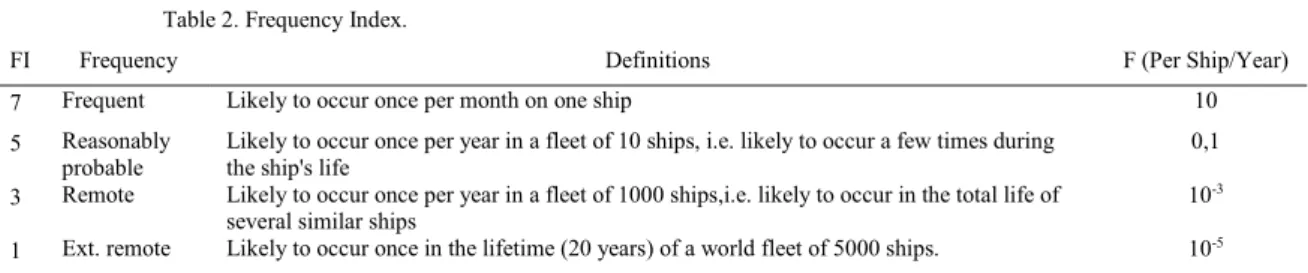
Table 2. Frequency Index.
FI Frequency Definitions F (Per Ship/Year)
7 Frequent Likely to occur once per month on one ship 10 5 Reasonably
probable
Likely to occur once per year in a fleet of 10 ships, i.e. likely to occur a few times during
the ship's life 0,1
3 Remote Likely to occur once per year in a fleet of 1000 ships,i.e. likely to occur in the total life of several similar ships
10-3
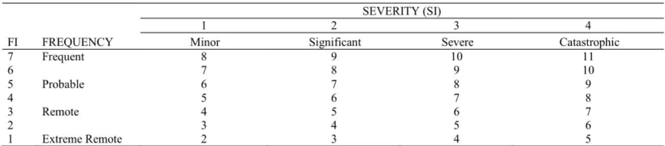
Table 3. Risk Index.
FI FREQUENCY
SEVERITY (SI)
1 2 3 4
Minor Significant Severe Catastrophic
7 Frequent 8 9 10 11 6 7 8 9 10 5 Probable 6 7 8 9 4 5 6 7 8 3 Remote 4 5 6 7 2 3 4 5 6 1 Extreme Remote 2 3 4 5 2.3. Risk Analysis
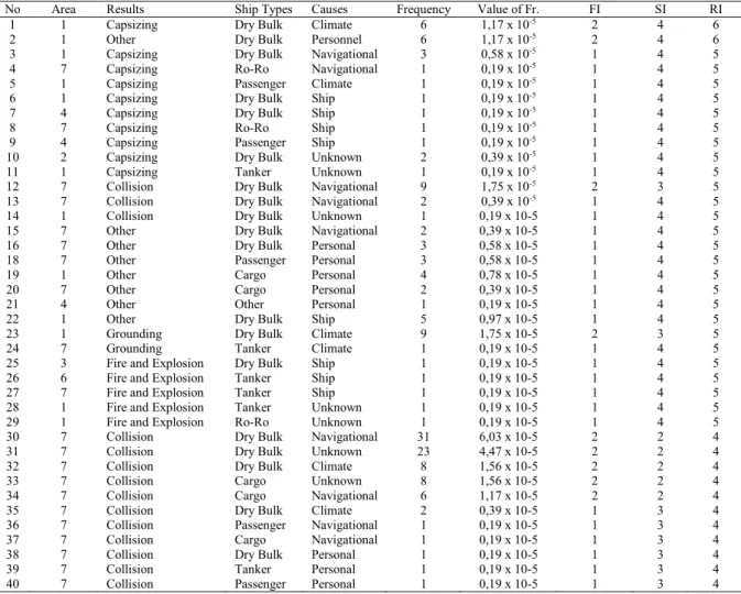
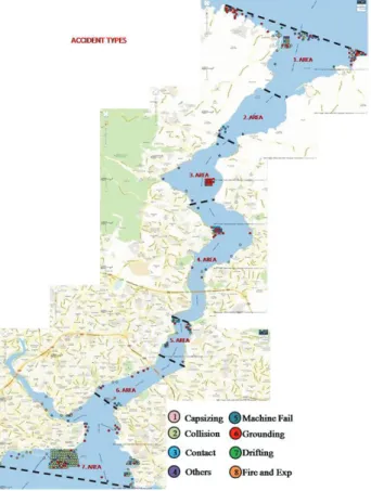
For risk analysis of the Istanbul Strait, statistical data of accidents which occurred in the Istanbul Strait from 2001 to 2010 were analyzed. In the Bosphorus different accident types were seen in this period, such as grounding, collision, capsizing, fire and explosion, drifting, machine failure and others. Lu has categorized marine accidents in two parts. According to the author, vessel accidents can be categorized as vessel failures and crew accidents (Lu et al, 2008). Vessel failures include foundering, flooding, stranding, groundings, collisions, capsizing, listing, fire/explosions, machinery damage, and other casualties to ships, while crew accidents are injuries sustained as a result of slips and fall on and overboard, during the operating of hatches and winches and other machinery, the use of ropes and hawses, exposure to substances, and those reported as missing at sea (Li, 2002). Four factors which are important when accidents occur were selected as ship type, the cause of accident, the scene of accident and accident time. For the FSA approach, the selected ship types are dry bulk, tanker, container, passenger ships, cargo, navy Ro-Ro ships and other ship types. Causes of accident are related with navigation, personnel, climate and weather conditions, ships and machines as well as unknown agents. For the scene of accidents, the Istanbul strait is divided into seven parts from south to north. Finally, regarding accident time, one day is divided into six equal parts from 00:00 to 24:00. See Table-1 for the frequency of accidents according to these criteria, different time zones and ship
types. Most accidents occurred in the first region and the number of dry bulk ships is higher than other ships. In the scope of this study, different scenarios are determined according to accident factors.
Table 4. Ship Types and Accident Zones.
Ship Types ZONE 1 ZONE 2 ZONE 3 ZONE 4 ZONE 5 ZONE 6 ZONE 7
Dry Bulk 67 4 18 23 16 6 111 Tanker 8 0 2 4 4 5 17 Ro-Ro 1 0 0 0 0 0 2 Passenger 5 1 1 1 1 3 27 Cargo 8 1 1 2 3 1 28 Container 2 1 0 0 2 0 5 Navy 0 0 0 0 0 0 0 Other 3 1 1 1 0 0 4
2.4. Determining Risk Scenarios
This analysis makes use of large amounts of diverse datasets, the most important of which are marine accident data (Mullai and Paulsson, 2011). In the process of determining the accident scenario, all accidents should be collected and every accident should be designated to different accident scenarios. The vast majority of accident studies rely heavily on case histories (Haastrup and Brockhoff, 1991). The use of risk analytical approaches in Formal Safety Assessment to improve maritime safety is dependent on comprehensive and accurate statistical data, in practice based on the recorded data of ship accidents (Hassel et al, 2011). At the beginning four selected accident factors are considered. Finally, each accident is defined in a different scenario. Within the scope of subjects, 391 accidents in total occurred in the Istanbul Strait in the period which was considered. Accidents were most commonly seen in the seventh area and the accident ratio of dry bulk carriers was higher than other ships. Cargo ships had the second highest number of accidents. At the same time, tanker ships were exposed to forty accidents in this strait.
When accident scenarios which are affected by different factors are examined, 222 accident scenarios emerged. In this study, scenarios that had the highest risk value were selected. 40 accident scenarios were determined for risk assessment of the Istanbul Strait.
The risk value of dry bulk ships that capsized due to climate and weather conditions was the highest between these years. Secondly, dry bulk ships that incurred other hazard types due to personnel (human failure) had the second highest risk level. In addition, the highest accident frequency was in the seventh area and dry bulk ships were involved in collision scenarios caused by navigational failures 31 times. However, the highest risks were capsizing by dry bulk ships and the highest accident frequency was collision of ships of the same type. In the Istanbul Strait, 31 deaths, 3 injuries and 23 cases of missing were reported by the authorities between 2001 and 2010. One death occurred per twelve accidents, an injury occurred per 130 accidents and one missing case occurred per 17 accidents. From 2001 to 2010, the prominent reason for accidents was collision. 159 of the total marine accidents were collisions in the Bosphorus. However, the number of collision scenarios was lower than the number of collisions. The reason for this is that accidents which result from collisions have a similar characteristic with accident types, ship types, cause of accidents, etc. In general, navigational factors cause collisions. Of the total accidents on the Bosphorus, collisions occurred 69 times and grounding occurred 16 times. In addition to that, the ratio of dry bulk ships was higher than other ships. Factors related to weather and climate conditions affected accidents which resulted in grounding.
Table 5. Accident Scenarios in the Istanbul Strait.
No Area Results Ship Types Causes Frequency Value of Fr. FI SI RI 1 1 Capsizing Dry Bulk Climate 6 1,17 x 10⁻⁵ 2 4 6
2 1 Other Dry Bulk Personnel 6 1,17 x 10⁻⁵ 2 4 6
3 1 Capsizing Dry Bulk Navigational 3 0,58 x 10⁻⁵ 1 4 5
4 7 Capsizing Ro-Ro Navigational 1 0,19 x 10⁻⁵ 1 4 5
5 1 Capsizing Passenger Climate 1 0,19 x 10⁻⁵ 1 4 5
6 1 Capsizing Dry Bulk Ship 1 0,19 x 10⁻⁵ 1 4 5
7 4 Capsizing Dry Bulk Ship 1 0,19 x 10⁻⁵ 1 4 5
8 7 Capsizing Ro-Ro Ship 1 0,19 x 10⁻⁵ 1 4 5
9 4 Capsizing Passenger Ship 1 0,19 x 10⁻⁵ 1 4 5
10 2 Capsizing Dry Bulk Unknown 2 0,39 x 10⁻⁵ 1 4 5
11 1 Capsizing Tanker Unknown 1 0,19 x 10⁻⁵ 1 4 5
12 7 Collision Dry Bulk Navigational 9 1,75 x 10⁻⁵ 2 3 5
13 7 Collision Dry Bulk Navigational 2 0,39 x 10⁻⁵ 1 4 5
14 1 Collision Dry Bulk Unknown 1 0,19 x 10⁻⁵ 1 4 5 15 7 Other Dry Bulk Navigational 2 0,39 x 10⁻⁵ 1 4 5 16 7 Other Dry Bulk Personal 3 0,58 x 10⁻⁵ 1 4 5 18 7 Other Passenger Personal 3 0,58 x 10⁻⁵ 1 4 5
19 1 Other Cargo Personal 4 0,78 x 10⁻⁵ 1 4 5
20 7 Other Cargo Personal 2 0,39 x 10⁻⁵ 1 4 5
21 4 Other Other Personal 1 0,19 x 10⁻⁵ 1 4 5
22 1 Other Dry Bulk Ship 5 0,97 x 10⁻⁵ 1 4 5
23 1 Grounding Dry Bulk Climate 9 1,75 x 10⁻⁵ 2 3 5 24 7 Grounding Tanker Climate 1 0,19 x 10⁻⁵ 1 4 5 25 3 Fire and Explosion Dry Bulk Ship 1 0,19 x 10⁻⁵ 1 4 5 26 6 Fire and Explosion Tanker Ship 1 0,19 x 10⁻⁵ 1 4 5 27 7 Fire and Explosion Tanker Ship 1 0,19 x 10⁻⁵ 1 4 5 28 1 Fire and Explosion Tanker Unknown 1 0,19 x 10⁻⁵ 1 4 5 29 1 Fire and Explosion Ro-Ro Unknown 1 0,19 x 10⁻⁵ 1 4 5 30 7 Collision Dry Bulk Navigational 31 6,03 x 10⁻⁵ 2 2 4 31 7 Collision Dry Bulk Unknown 23 4,47 x 10⁻⁵ 2 2 4 32 7 Collision Dry Bulk Climate 8 1,56 x 10⁻⁵ 2 2 4 33 7 Collision Cargo Unknown 8 1,56 x 10⁻⁵ 2 2 4 34 7 Collision Cargo Navigational 6 1,17 x 10⁻⁵ 2 2 4 35 7 Collision Dry Bulk Climate 2 0,39 x 10⁻⁵ 1 3 4 36 7 Collision Passenger Navigational 1 0,19 x 10⁻⁵ 1 3 4 37 7 Collision Cargo Navigational 1 0,19 x 10⁻⁵ 1 3 4 38 7 Collision Dry Bulk Personal 1 0,19 x 10⁻⁵ 1 3 4 39 7 Collision Tanker Personal 1 0,19 x 10⁻⁵ 1 3 4 40 7 Collision Passenger Personal 1 0,19 x 10⁻⁵ 1 3 4
2.5. Analysis of Risk Scenarios
When all the accidents are analyzed, collision, grounding and others had the highest frequencies in the Istanbul Strait from 2001 to 2010. Moreover, they can cause loss of life and damage economic assets such as ships and cargo. Capsizing had low frequency, but it had a higher risk level than other accident types. Marine accidents caused different results which are defined as incident costs. The literature on incident costs indicates that it is very complex to determine realistic base values. Wood (Wood, 1995) identifies four components of marine incident costs which are lost assets, loss of cargo, loss of lives, and pollution (Talley, 1999). Especially marine accidents affected marine pollution mostly.
More than 70% of the oil that ends up in the sea emanates from sources other than maritime transport such as land-based activities and industrial waste. Ventikos and Psaraftis investigated vessel damage costs differentials for some ship types as well as determinants of property damage costs of tanker accidents, (Ventikos and Psaraftis, 2004). and Goulielmos and Giziakis considered uncompensated costs of marine accidents. (Goulielmos and Giziakis, 1998). The second important accident type in the Istanbul Strait is grounding. From 2001 to 2010, 58 grounding accidents occurred in this area. Grounding can be seen in Anatolia shallows of lighthouse, Yeniköy and Umurbey shallowness, and Ahırkapı and harem coastal areas. The cause of this is that the depth of these marine areas is low and weather as well as climate conditions have more effect than in other marine areas. Therefore, the most important cause of grounding accidents is weathering and climate conditions on the Bosphorus. Grounding accidents show that, the ratio of pilot boarding to ships was high, 26 ships were exposed to an accident without a pilot. Furthermore, 58 ships grounded although these ships had taken a pilot. Collisions could be seen in Ahırkapı, Harem and near the lighthouse of Türkeli. Especially in the Ahırkapı marine area, the most important cause of collisions is the large number of ships. In contrast, the reason for the collisions that have occurred in other areasis the dual axis of marine traffic as international (vertical) and domestic traffic (horizontal) in this strait. However, ships can be crossing in these marine routes. As the most important evidence of this, the ratio of accidents of domestic passenger ships has reached a high value in the Harem and Türkeli marine areas.
When we analyze the causes of collisions, we can see that the causes of these collision accidents can be different for each marine area. For the seventh marine area in the Istanbul Strait, the most important cause of accidents is anchorage failure. From the sixth to second marine areas, maneuver and navigational errors are the most important accident causes.
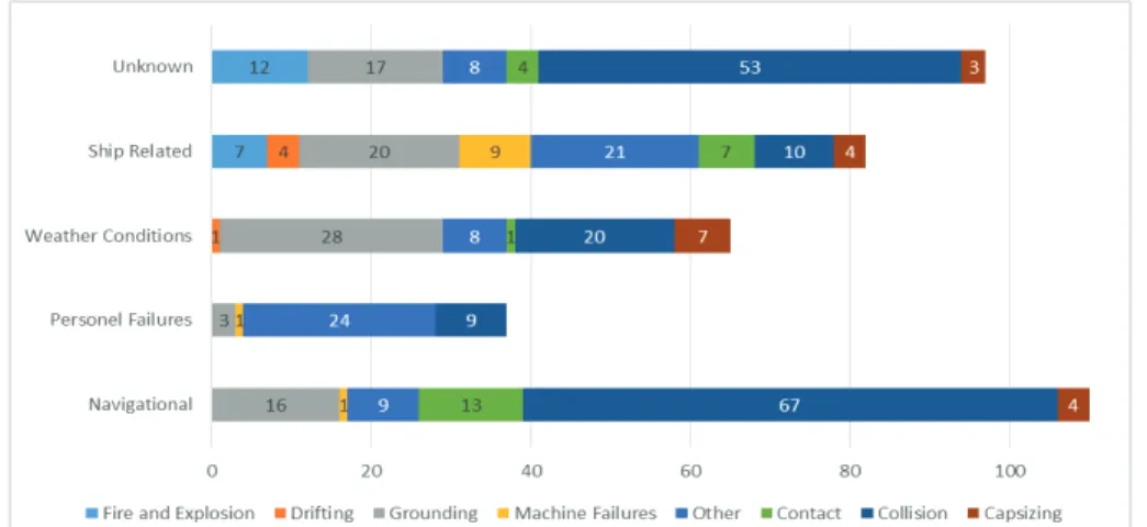
Fig. 1. Accident Types and Causes.
For the first marine area, weather and climate conditions affected ship traffic and led to the collision accidents. In collision accidents, four deaths and two injuries were seen, and especially accidents affecting people occurred as a result of navigational faults. Accidents resulting in death occurred with dry bulk and passenger ships. When the economic losses are evaluated, the total losses were two ships, very heavy damage in one ship, heavy damage 24 times, slight damage 121 times and 11 times no hazards were recorded. Fire and explosion accidents, the most
important causes of which are unknown, were generally seen in the Türkeli and Haliç marine areas. The second important type of accidents resulted from navigational fault, causes of which were either unknown or related with the ship. In this accident type, mostly dry bulk and tanker ships were subjected to fire and explosion. Almost all accidents related to fire and explosions happened in large ships above 1000 GRT and most of them occurred in the afternoon, between 12:00 and 16:00 . In the Istanbul Strait, fire and explosion accidents have occurred 19 times. In
these accidents, the risk value of fateful accidents is 10.52%. In addition, 12 of these accidents, 84%, resulted in very heavy damage and heavy damage was seen in 15.79% of these accidents. Fire and explosion accidents had a higher risk level than other accident types in terms of economic losses.
In the Bosphorus, other accident types have importance; other accidents can be defined as medical evacuation, sanitary assistance, and hazardous incidents, falling into the sea, etc. Other accidents have been seen 70 times in the Bosphorus. While the ratio of death was 12.85% in these accidents, injuries were seen in 4.28%28 and 1.43% of these accidents resulted in missing cases. By contrast, damage was not seen in 80% of these accidents.
2.6. Determining Risk Control Options
Related to determining the risk control options, all the most important accident factors have been analyzed and their risk levels have been put forward to prevent hazards. Therefore, risk reduction measures are listed by their importance. Accordingly, the vast majority of accidents occurred in the seventh marine area and dry bulk ships and collisions had higher accident frequency and risks than others. For this reason, this marine area should be monitored more carefully. On the other hand, a significant proportion of grounding and collision accidents occurred due to anchoring errors. All of the ships entering the anchoring area must anchor in accordance to anchoring rules. In particular, significant proportions of grounding and collision accidents were affected by weather and climate conditions. Drizzle and southwestern winds affect marine traffic adversely. In these conditions grounding and collisions occurred due to low visibility. According to Otto et al., the danger of collision and grounding is influenced by environmental conditions in the considered sea area. Limiting the marine traffic when drizzle and southwestern winds appear can help reducing the risk of accidents. Since Umurbey Bankı, Yeniköy, Kuruçeşme and Türkeli are marine areas that have seen grounding more than other marine areas, these parts of the Istanbul Strait must be monitored and controlled more carefully. The most important cause of grounding that occurred near Umurbey Bankı and Yeniköy was captain failure. In this area, ships may leave from the ship separation scheme and because of low visibility ships cannot see the ships coming from the other direction. As a result, collision risk may increase. When ships see others that come from the other direction, they may prefer grounding instead of collision. However, the ship separation scheme must be monitored and breaking these rules must be avoided. In the Istanbul Strait, one of the most important causes of collision, grounding and capsizing is navigating without a pilot. When ships take a pilot, the accident risk can be decreased. For this reason, pilotage should be encouraged by ships in accordance with the Montreux Convention on the Bosphorus. However, providing some financial advantages to ships which take pilots may increase the ratio of vessels that take a pilot. In order to ensure marine safety, ships that are passing through the Istanbul Straits should be recorded and in the subsequent times, ships which have violated safety codes should be monitored more carefully. Risk level records must be taken for all the ships and safety codes with different colors should be given to ships passing through the Istanbul Strait.
Weather and climate conditions which cause low visibility are the most important causes of marine accidents on the Bosphorus. Generally, ships navigate at speeds of 10 and 15 knots. As a result, a ship that passes at 10 knots is out of 420 meters. In the third marine area, vessels which are navigating in opposite directions can see each other before nearly 5000 meters. Five minutes is a sufficient time to notice the collision even if both ships are navigating at 10 knots however, reaction time is very short. According to Qu’s study based on the expert judgment from ship captains, greater speed variance indicates a higher likelihood of vessel collision (Qu et al, 2011). To extend the reaction time, marine traffic should be stopped for both directions when visibility goes down to at least one nautical mile. At the same time, navigational speed must be 10 knots in the Istanbul Straits according to COLREG 72 regulation. Another important risk factor is personnel related. 39 accidents have been due to human failure, while 9.20% of total accidents occurred due to human fault. In order to reduce accidents that are affected by human errors, the reviewing and updating of training of personnel of ship that pass through the strait could be helpful. In this
context, information related to vessel staff could be demanded from ships. A significant proportion of the accident causes is unknown.
Fig. 2. Accident Types and Accident Areas.
These conditions show that accident reporting is not sufficient for accident analysis. As a result, observations of accidents can show deviations. Although often reports by captain and vessel staff are considered, the ship's crew may hide the real causes, so reports should be realistic and prepared in detail and they should be questioned by authorized personnel. Accidents have occurred in Istanbul in the past and taking the related details into account, emergency action plans should be prepared and existing plans should be updated continuously. In the Istanbul Straits, 77 accidents occurred between 00:00-04:00 and 44 accidents between 04:01-08:00. Accidents occurred between 08:01-12:00 hours 47 times, 69 accidents occurred between 12:01-16:00 hours, 74 accidents between 16:01-20:00 and 80 accidents occurred between 20:01-23:59. When these data are analyzed, accidents between 20:01 and 04:00 had the highest accident frequency and risk level. The hours of darkness on the Istanbul Strait are more unsafe than other times.
2.7. Cost – Benefit Analysis
Cost - benefit analysis is the process of evaluating of the cost and benefits of risk reduction measures. In this step, if the benefits of a risk reduction option have a higher value than the cost of measure values, it may be selected and applied. In the case of Bosphorus, for each accident factor when the risk is reduced by 20%, the numbers of accidents and danger level may be decreased substantially. If ships are monitored more carefully in terms of the prevention of ship based accidents, ship based risk may be reduced and at least 15 ship based accidents may not occur. Total risk may be reduced by 3.83% and for other accident types similar results may be seen.
2.8. Recommendations for Decision Makers
The implementation of FSA methods can reduce accident risks and the numbers of accidents in the Istanbul Strait. However, risks cannot be reset completely, at least in the short and the medium terms. In this assessment, risk value reached 6 in the Istanbul Straits and it can be defined as high risk, which should be considered, but they have not reached intolerable levels. Risk reducing techniques should be applied continuously and each improvement related to marine safety must be recorded and it cannot be seen as unimportant. As a priority, the transportation of dangerous goods by sea (especially chemicals and petroleum products) must be monitored more carefully. Only when we focus on LPG and LNG tankers, awareness of the danger can be achieved more successfully. The harm that an explosion of an LNG or LPG tanker causes may be equal to an 11 magnitude earthquake in the Istanbul Strait (Başaranel et al, 2011). At the same time, a 50 km-wide zone would be affected because of this disaster. When conditions of the Bosphorus are evaluated, 1100 LPG and LNG tankers passed through the Istanbul Straits in 2010, and the Istanbul Straits were exposed to the risk that caused this type of ship accidents 1100 times annually. Recommendations may be seen as below;
x Monitoring marine traffic more carefully: Especially in the Ahırkapı and Harem marine areas, marine traffic should be monitored better. This option may help to reduce the collision risk. When the risk level is reduced 20.38% accidents may not appear for every decade.
x Sufficient Anchoring: to solve the problems which are caused by insufficient anchorage, necessary measures must be taken in anchoring areas.
x Checking the machines and navigation equipment: controlling the machines and equipment is important for reducing ship related accidents. All the ships must be checked before entering and poor vessels should not be allowed passage.
x Limitation of marine traffic in bad weather conditions: especially in bad weather conditions, marine traffic must be limited better for the reduction of accidents which are caused by weather and climactic conditions.
x Better monitoring of the high risk areas: Ahırkapı, Türkeli, Umurbey and Yeniköy are higher risk areas than other marine areas. Therefore, these areas must be monitored more carefully.
x Constitution of emergency intervention teams: emergency intervention teams should especially be constituted in high risk areas. They should include marine firefighting teams.
x Vessel registry for passage: some ships have a high risk level and these vessels should be recorded. According to these records, ships which have high accident risks at an unacceptable level must be monitored more carefully. x Determination of speeds: according to COLREG 72, safety speeds should be determined for the Istanbul Strait and
it may be different for each marine area. Emergency planning: Preparing accident scenarios and according to these, preparing emergency plans and realizing the practices are important in order to be prepared for the risks.
3. Conclusion
Today, the great majority of world trade takes place by sea. In this context, the Istanbul Straits have a very important role in the world trade. In particular, this marine area has almost no alternatives and it is crucial for Black Sea countries. The Istanbul Strait has a number of difficulties for marine traffic. Its geographic and climactic conditions make passage difficult. At the same time, international marine traffic is increasing annually. Today marine traffic has reached the highest level in these straits and the increased traffic has caused marine safety problems. There is an inverse correlation between marine safety and marine traffic. Today 9 billion people who live near the Bosphorus are at risk of marine related accidents in Istanbul. Only when we consider the risk to human life, can we see that the risk has reached a high level in the Istanbul Strait. This paper first summarizes the accident statistics for the Istanbul Straits in the last 10 years. In this marine area there was 1.17–0.19 accident risks per 100.000 ship passage. Collision was the dominant type of accident. Most of the accidents happened in the seventh or the first areas. The largest categories of primary causes were navigational and unknown factors. Marine traffic in the Istanbul Straits have different risk parameters such as accident types, vessel types and specifications, accident time and season, cargo carried types, locations and so on. According to statistical data sets related to marine accidents, collision is the most important accident type and it has occurred 159 times; the ratio of collision is nearly 41%. The
second important accident type is grounding. It was seen 84 times between 2001 and 2010. In the Istanbul Straits, the most common causes of accidents are navigational, unknown and ship related factors. While navigational errors were 110 times, unknown factors affected accidents 97 times and ship related factors occurred 82 times. The months of the greatest risk for accidents are January (52), February (40) and April (35) and the time of the highest risk level is during the darkest hours of the day: 20:01-23:59 and 00:00-04:00. Dry bulk ships have the highest risks, the ratio of dry bulk vessels is nearly 63% and these vessels caused accidents 245 times. The capacity of the ships that were exposed to accidents was mostly 1001-10.000 GRT. It was seen 238 times. With an accident rate of 69%. Only 13 accidents occurred in large vessels of over 200 meters. However, the 3% ratio of large ships related to the accident and the risk level of vessels that are smaller than 200 meters is high. When analyzing all the accident data and indicators related to marine accidents in the Istanbul Strait, marine risk is high and it has increased continuously. While some factors have the highest risks as large ships, dangerous goods transportation and tankers may be comparatively under control. Other risk factors may lead to danger because they were not considered sufficiently. When applied to the determined risk control options, marine risks may reduce sufficiently.
References
Akten, N. (2004). Analysis of shipping casualties in the Boshporus. The Journal of Navigation, 57, pp.345-356.
Or, I., Özbaş, B., Yılmaz, T. (2007), Simulation of maritime transit traffic in the istanbul strait – II: incorporating the traffic regime, arrival processes, meteorological conditions, Meteorological Conditions in Proceedings of 21st European Conference on Modelling and Simulation, 4-6 June 2007, Prague. Czech Republic.
Doğan, E., Burak, S. (2007). Orginated pollution in the Istanbul Strait (Bosphorus) and Marmara Sea, Journal of Coastal Research, 23 (2), pp.388-389.
Hu, S., Fang, Q., Xia, H., Xi, Y. (2007). Based on relative risks model in ship navigation, Reliability Engineering & System Safety, 92 (3), pp.369-377.
Psarros, G., Skjong, R., Eide, M. (2010). Under-reporting of maritime accidents, Accident Analysis and Prevention, 42, pp.619–625.
Peachey, J.H. (1999). Managing risk through legislation, managing risk in shipping. A Practical Guide, The Nautical Institute’s Publication, London, pp.93–100.
Marine Safety Agency. (1993). Formal safety assessment MSC66/14. London: Marine Safety Agency, (Submitted by the United Kingdom to IMO Maritime Safety Committee).
Wang, J. (2002). Offshore safety case approach and formal safety assessment of ships, Journal of Safety Research, 33, pp.81– 115. Kontovas, C. A., Psaraftis, H. N. (2009). Formal Safety Assessment: A Critical Review Marine Technology, 46 (1), pp.45–59.
IMO. (1997). Interim guidelines for the application of formal safety assessment (FSA) to the IMO rule-making processes, MSC/Circ. 829 and MEPC/Circ. 335, London.
Abou, C. (2012). Fuzzy-logic-based network for complex systems risk assessment: Application to ship performance analysis, Accident Analysis and Prevention, 45, pp.305–316.
Rosqvist T., Tuominen, R. (2004). Qualification of Formal Safety Assessment: an exploratory study, Safety Science, 42, pp.99–120.
Lu, C. S., Tsai, C.L. (2008). The effects of safety climate on vessel accidents in the container shipping context, Accident Analysis and Prevention, 40, pp.594–601.
Li, K.X. (2002). Maritime professional safety: prevention and legislation on personal injuries on board ships, IAME 2002 Conference Proceedings, Panama.
Mullai, A., Paulsson, U. (2011). A grounded theory model for analysis of marine accidents, Accident Analysis and Prevention 43, pp.1594. Haastrup, P., Brockhoff, L.H. (1991). Reliability of accident case histories concerning hazardous chemicals – An analysis of uncertainty and
quality aspects. Joint Research Centre Ispra, Italy. Journal of Hazardous Materials 27, p.339–350.
Hassel, M., Asbjørnslett, B.E., Hole L. P. (2011). Underreporting of maritime accidents to vessel accident databases, Accident Analysis and Prevention, 43, pp.2053– 2063.
Wood, J. (1995). Opa 90. Maritime Policy and Management 22, pp.201.
Talley, K.W. (1999). Determinants of the property damage costs of tanker accidents. Transportation Research D, 4, pp.413–426.
Ventikos, N. P., Psaraftis, H. N. (2004). Spill accident modeling: a critical survey of the event-decision network in the context of IMO’s formal safety assessment, Journal of Hazardous Materials, 107, pp.59–66.
Goulielmos,.M., Giziakis, K. (1998). Treatment of uncompensated cost of marine accidents in a model of welfare economics. Disaster Prevention and Management 7, pp.183–187.
Qu, X., Menga, Q., Suyib L. (2011). Ship collision risk assessment for the Singapore Strait, Accident Analysis and Prevention, 43, pp.2030 – 2036.
Başaraner M., Yücel, M.A., Özmen, Ç. (2011). İstanbul Boğazı’nda Transit Gemilerin Kullandığı Seyir Rotalarının Coğrafi Bilgi Sistemi Yardımıyla İncelenmesi ve İyileştirilmesi, Jeodezi, Jeoinformasyon ve Arazi Yönetimi Dergisi, 3, pp.75-79.