ABSTRACT: Use modified freeze-drop ball test was used for investigation of the crack propagation rate in tunneling and coal mining- case study for the coal shale, marly shale and marl in Şırnak city coal site.
The coal mine excavations create the roof disturbances greater the issue to encounter in situ ground operation conditions. The roof rock shale and coal contacts in underground space makes an inadequate strength and safety issue of the operation work is more difficult, especially in water absorption concern of coal side rock. The lump-size marl, marly shale and shale rock types and distribution and compression were investigated by modified freeze test regarding the conditions in the post excavation field of coal by time. Rocklab and Stereonet7 programs performed with four types of rock and crack propagation analysis for A1, A2, A3 and A4 types of rock were investigated. Anisotropy of rocks and mixture models were tested in laboratory scale. Heterogeneous crack parameters were analyzed. Regarding the analysis, shale and marly shale type rocks, A1, A2 were poor to stable state that showed greater rate crack propagation to be high safety risk. However, anisotropic layer of limestone in marly shale through water absorption exhibited lower stability in coal contacts as seen in coal sites. Because of growing demand, the high safety condition of mine excavation site is required and has to be concerned.
In the stable ground, the cracked side rock has to be covered and supported in order to avoid consolidation and rock bursting. This modified test also measures the impact resistance of rocks tested for use in the scaling to 30-40 cm lump massive rock models in laboratory to provide face scale to 2-3 m. The indentation by the drilling bit enters in-situ the massive lump rock, where the volume of rock retained can regulate through the advance rate. Depending on the resistivity of the rock volume in the head distance, the indentation pressure can be controlled.
KEYWORDS: drop ball test, freeze cracking, crack cementing, crack strengthening.
1 INTRODUCTION
In the developing countries, according to the topography of land in the mountainous areas, improper use of land increases the possibility of developing landslide. During earth excavations and constructions the landslide hazardous areas may not be considered (Anbalagan, 1992, Ulusoy ,1982, Ulusoy, 1989).
Generally landslide hazardous area can be described as “possible sliding masses which make an angle with the surface” (Cernica, 1995; Das, 1994). Slope stability and landslide problem dealing with the ground have been closely worked for many years by geotechnical engineers. For this reason, the deep disorder of land masses and slope stability, flood, are known as natural disasters such as hurricanes, similar to leading to serious loss of life and property (Anderson & Richards, 1982). With the increase of population growth there is a great need for the fields in long natural slopes. In these fields, people require some excavation, drainage precautions, different urban constructions, specific vegetation which can protect natural balance. However, the natural land
Use of Modified Freeze-Drop Ball Test for Investigation the Crack
Propagation Rate in Coal Mining- Case Study for the Şırnak
Asphaltite Shale, Marly Shale and Marl in Şırnak Coal Site
Yıldırım İsmail Tosun
a*
aŞırnak University,Mining Eng.Dept., Şırnak*
mass stability can be concerned of the reasons such as heavy rains or earthquakes (Bishop, 1955, Höek, 1970; Höek, 2013; Höek & Brad, 1977).
The civil engineers are much interested in the foundation issues regarding the earth soil, surface created by the nature, the slope geometry and design of the structures built on land (Lambe & Whitman, 1969, Paşamehmetoğlu et al., 1991, Hutchinson, 1995). The technological development parallel to the housing needs the high embankment, dams, large and deep excavations along with stability problems. Each year, few flood and landslide damages may cause to heavy loss of life. They also cause to loss of the millions of pounds in the world. The landslide in Turkey is one of the most important geotechnical hazards.
In this study, Şırnak city and the surrounding area were studied by geological mapping at 1/1000 scale and the soil units. The properties of every unit soil were determined. Landslide hazardous area provisionally was concerned in the first region's landslide area. The soil properties worked promotes the construction distributions in the future in Şırnak City, promoting winter tourism, one of the popular South eastern Anatolian land. The importance of civil constructions under the threat of landslide intended to draw attention to the urbanization of the area.
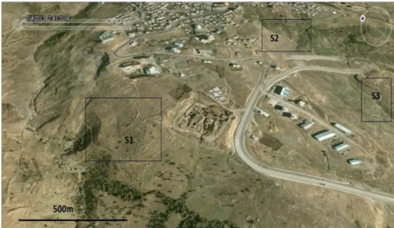
In order to minimize the landslide hazard, geological and geotechnical analysis of the land slopes were needed to be studied. In this study, in the area of south Şırnak City (Figure 1) 2 km circled from the center of the slopes S2 was investigated as much critical hazardous area due to some mass sliding occurred in the district. Geotechnical properties soils of four different locations were determined for examining the stability analysis. This project was carried out for urban use, which will open workspace and environment covering the engineering geological mapping of the field of 4 km2 area at 1/10.000 scale. The laboratory studies followed by the polar coordinate system using a field study with the topographic maps and cross-sections of four slopes were prepared.
2 GEOLOGY OF THE PROVINCE OF ŞIRNAK CITY
Southeastern Anatolian Region has certain tectonic structures and stratigraphy containing the fault system and especially tension cracks along the ground to the depths. Underground waters, geothermal energy fluids flow the deep formations (Anonymous d, 2012). North-south direction across the region with the effect of compression of the earth's crust has been subjected to a stretching east-west direction, and the resulting tension cracks along the earth have risen from the olivine magma (Altınlı, 1970, Anonymous c, 2011).
Figure 1. Satellite Image of The Study Area and The Slopes in Şırnak City.
Alluvium, dissociated limestone in the recent study area of Şırnak City (Figure 2) is distributed among the alluvial deposits of the neighborhood. There are the limestone gravels in the area and very well rounded pebbles associated with soil. Alluvium soil, muddy shale occurs in wide urban living area of Şırnak City at the south, which field as seen in Figure 1 extends to the study area. In field observations, the Miocene aged limestone and dissociated limestone were determined. Thickness of this formation is highly variable among 2-30m. Decrease in the slope of the land shows that a relatively small outcrop occurs.
Southwestern limestone is moderately dissociated due to the deteriorated rock formations into the layers. Due to the resistance, large parts of rock at 50-90% rate are different. The cracks on the
surface of the rocks are dominated by brown and blackish color. In the study area, the cross-section (Figure 2) shows the extent of moderately, or highly dissociated formation along the valley portion. In those regions, the separated segments of the shale are observed.
Figure 2. The Geologic Cross-section of The Şırnak City.
The study area to the north of the city contains fundamentally higher land slopes in the urban location. The observations of sorting and grading of unseen alluvial fill show a thickness varies between 10-35 m. The high slope massive fills are concerned as active and potential hazardous landslide areas and are requiring for various examinations.
3 GEOTECHNICAL PROPERTIES
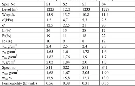
The representative contents of drilling logs were taken from the rectangular fields as seen from Figure 1.The representative samples of soil were taken from each different location over the slopes. The experiments conducted to determine the geotechnical characteristics regarding the Turkish Standards (TS 1900) and American Standards (ASTM 3080) (TSE, 1987, ASTM, 1990). Regarding the logs of wells of 58m, 135m in 2003, 60m, 574m wells, the mechanical properties of soils are given in Table 1.
In the study area of fine-grained portions of alluvium samples were taken from slopes as undisturbed and disturbed sample logs. The results of the experiments conducted on the samples of disturbed soil grain distribution curve, unit weight and consistency limit grain sizes are given in Table 1 (TSE, 1975, TSE 1991). The bulk density of the material, and the void ratio were determined with compression amount. Plastic and liquid limit results obtained in the experiments for each sample are given in Table 1. According to the classification of the soils in S1 and S2 landslide hazardous areas, the soils were determined as less plastic and non plastic group, even the soils of S3 and S4 in the landslide hazardous area were determined as less plastic.
Table 1. Properties Soil Formation in Şırnak City.
Spec No S1 S2 S3 S4 Level (m) 1225 1221 1233 1227 Wopt,% 15.9 13,7 10,8 11,4 c′(kPa) 1,2 4,7 5,3 2,5 ϕ′ 12,5 22,5 21 20 Lı(%) 26 15 28 17 Pı(%) 19 11 18 22 Ip (%) 10 9 8 12 γsat g/cm 3 2,4 2,5 2,4 2,3 γap g/cm3 1,65 1,6 1,78 1.6 γdry g/cm3 1,82 1,76 1,9 1,7 γs g/cm3 2,02 1,84 2,0 1,8 Spec. no S11 S22 S31 S41 γmax g/cm3 1,68 1,67 2,05 1,90 wopt % 15,9 15,8 12,3 13,0 Permeability (k) (mD) 0.56 0.38 0.31 0.56
Compression strength values depending on the increasing amount of fly ash and concrete reduced. Increase in fly ash amount used in the concrete mixture by curing time was found to reduce the porosity.
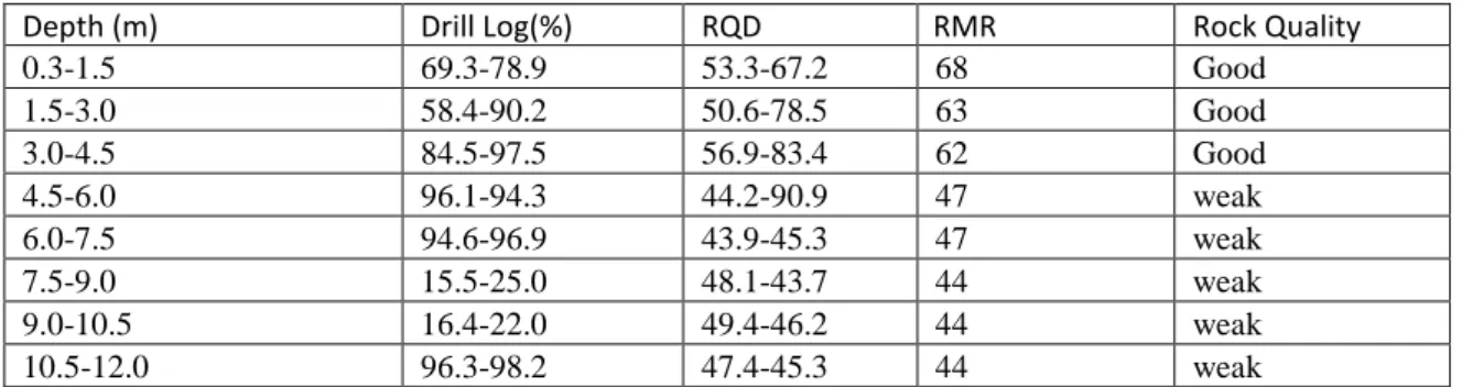
The representative rock fill samples were taken from the construction foundation and strengths with the bulk density are shown in Table 2. For determination of rock types based on logging were carried out and the results showed poor and good rock classification as given in Table 2.
In this study, coarse shale stone over 10 cm sizes as rock fill in the foundation and with concrete was used. The strength and the mechanical parameters of addition of rock fill as shale stone given in Table 3. The amount of fly ash on properties of water discharges in the landslide risk area was also investigated.
Table 2. The The Drilling Data and Calculated RQD by RMR Rock Classification Parameters.
Table 3. The Calculated values of landfill
c' and ϕ' values are taken as given in Table 3, respectively. In addition, the safety coefficient values were used as 1.3-1.5 in GEO5 program. The probable circular sliding surfaces were determined using the methods such as landslide, according to Fellenius, Bishop and Janbu calculations (Pruska, 2009, Görök & Török, 2006, Görök & Török, 2007).
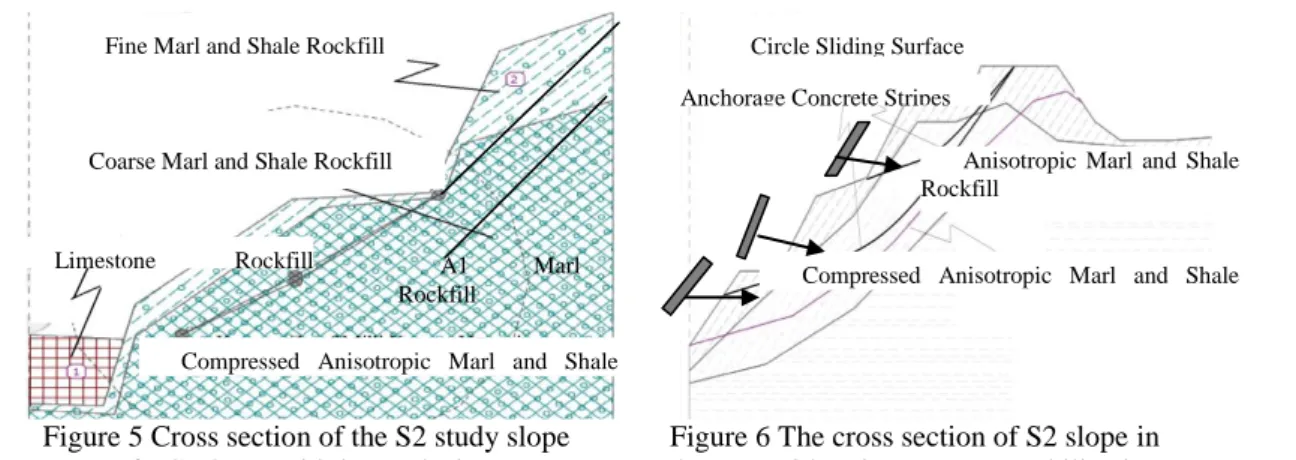
Fig. 3 Cross section of the S2 study slope for GEO5 sensitivity analysis.
Fig. 4 Stereonet 7 diagramme of the S2 study slope for GEO5 sensitivity analysis.
y = 0,0568x3 - 0,4038x2 + 1,8378x + 0,2587
R² = 0,9995
y = -6E-14x3 + 3E-13x2 + 1x + 4E-13
R² = 1 y = 0,0329x3 - 0,2428x2 + 1,5584x + 0,0388 R² = 1 0 0,5 1 1,5 2 2,5 3 3,5 4 -0,1 0,4 0,9 1,4 1,9 2,4 2,9 3,4 S h ea r S tr ess,M P a
Normal Stress, MPa A1-Original Marl
A2-30% Inclined Shattered Marl A3-60% Inclined Shattered Marl
Depth (m) Drill Log(%) RQD RMR Rock Quality
0.3-1.5 69.3-78.9 53.3-67.2 68 Good 1.5-3.0 58.4-90.2 50.6-78.5 63 Good 3.0-4.5 84.5-97.5 56.9-83.4 62 Good 4.5-6.0 96.1-94.3 44.2-90.9 47 weak 6.0-7.5 94.6-96.9 43.9-45.3 47 weak 7.5-9.0 15.5-25.0 48.1-43.7 44 weak 9.0-10.5 16.4-22.0 49.4-46.2 44 weak 10.5-12.0 96.3-98.2 47.4-45.3 44 weak
Natural Unit Weight, n ( g/cm3) 1.21
Saturated Unit Weight , d ( g/cm3) 1.44
Cohesion, c (kPa) 135
Internal Friction Angle, () 34
A 3 A 2 A 1 A 4
Figure 5 Cross section of the S2 study slope forGEO5 sensitivity analysis.
Figure 6 The cross section of S2 slope in the area with stripe concrete stabilization for stability analysis GEO5 FEM program
This kind of soil conditions in this study provide a circular or non- circular slidinging close quarters to the top of the slope begin as a deep developing and ongoing planar surfaces. In these type of instabilities developed along the sliding surface in order to investigate the stability of the slope the Bishop method is commonly used (Chen & Liu, 2008, Langan et al., 2002, Park et al., 2005).
At the construction site foundation the concrete wells in 2m diameters were excavated at elevation 1210 m to 10m depth to sliding face. At creeping slopes hazard of mass slide may be prevented by rock fill. Even 1 meter depth concrete landfill horizontal columns constructed as seen in Figure 4.
Belonging to the limit equilibrium factor of safety of slopes drawn in accordance with different sliding surfaces for the Bishop in GEO5 (Figure 5 and 6), with the circular shift diagram Janbu and Fellenius methods showed over 1.3 safety factors. In the field the observed tension cracks showed the active movement. In the case of concrete landfill, the intrinsic parameters of the sliding surface will appear smaller than those safety values found with the parameters in the soils without the landfill. It is clear that safety value was between 1.5 and 1.8 with the landfill. From this point of view, the concrete landfill of horizontal column improved water level under sliding surfaces and the safety factor values reached over 1.5 and 1.8.
4 CONCLUSIONS
Şırnak City located within the boundaries of four separate hill slopes and slope stability of soil samples should be taken from the site under construction. The geological and geotechnical properties investigated by field studies and laboratory experiments showed less plastic soil formations keeping water pore pressures.
Alluvium (Miocene), dissociated shale (Miocene) and the dissociated limestone (Miocene) are ranked propagating landslide hazardous manner of high slopes under construction sites.
The studied area of potential landslide hazard around the active site of stress, cracking displacement of relative motion could be observed, but changed regarding the field.
Soil samples performed on the laboratory test results in the slope material permeable that the cohesion value of 1.2 - 4.7 kPa, angle of internal friction of the 17.5 - 22.4o varied between unified soil classifications. Stability analysis performed in the light of this information, S1, S2 and S3 were unstable hillsides. By use concrete application the hazardous slopes were concluded that the stable condition.
As a result of the terrain views, especially in the months of May and June by the melting snow stream flow increase seen in the severe erosion of the slope formed on the heel and this effect was determined to have a negative impact on slope stability. Landfill material, or rock material or stream should be investigated and varied in water discharge effect.
In the experiments for different slope inclinations, especially in low-slope slope (1/1), very high security numbers (such as s 2.0) were obtained. Therefore, by increasing the slope of the land slope stability calculations should be renewed. Slope safety number began to decrease with increasing safety and below 1.3 (approximately over 50°) slope inclinations.
Limestone Rockfill Support
Coarse Marl and Shale Rockfill
Compressed Anisotropic Marl and Shale Rockfill
A1 Marl Rockfill
Fine Marl and Shale Rockfill
Anchorage Concrete Stripes
Compressed Anisotropic Marl and Shale Rockfill
Anisotropic Marl and Shale Rockfill
Rocky slope stability analysis done for the ground, rocky land, which had been dissociated from the floor to act differently, next to the sliding movement of the rock fall incidents, such as being able to vary hazardous parameters. In the rocky terrain of slope stability analysis in order to solve problems with similar method of landfill may not be sufficient, however as a specially crafted construction works should be used.
High strength landfill mass improved the slope stability. However, low strength concrete landfill might result in higher water discharge and drier soil condition.
Plants, rain water infiltration into the mass simplifies and reduces water runoff and cause land sliding. This is an obstacle to the erosion of the mass. Reaching deep into the roots of the plants roots improves the mechanical balance of the masses.
Landfill porosity thus reduces the retaining force which stabilizes the slopes. For this reason, the vegetation of landslide hazardous areas is preventive enrichment an important parameter in the region. However, up to 30 m depth to the sliding surfaces of vegetation stability effect will be minimal. Weathering of rocks varies greatly in to undergo, to the weakening of the bond between grains and leads to total extinction. In the study area weakened by weathering rocks are easily eroded and slope angle of inclination of the slope is changing with height. Dissociation observed in rocks in the study area also offers a negative contribution to stability problems.
For those reasons, geotechnical engineer can use virtual any classical slope stability programs, rock slope stability calculations in order to do construction safety.
As a result of this work performing of the geotechnical analysis, hazardous conditions would not be expected of a very large landslide. However, the urban living areas and the urban development areas at certain land slopes for the possibility of landslide hazard should need further technological improvements.
SYMBOLS
c ' kPa : Effective Cohesion c kPa : Cohesion
ɸ' degree: Effective angle of internal friction ɸ degree: angle of internal friction
σ MPa : Compression Strength Ip: Plasticity index
Ll: Liquid limit
Pl: Plastic limit
Wopt : optimum water content
ap g/cm3: apparent unit weight sat g/cm3: Saturated unit weight dry g/cm3 : Dry unit weight
max g/cm3: Maximum dry unit weight s g/cm
3
: Grain unit weight k mD: coefficient of permeability s: safety factor
S1: 1 The landslide
S11 : No. 1 No. 1 of the landslide zone samples taken from
SP: Unified soil classification; worst -graded sands, gravelly sands, little or no fines SW: Unified soil classification; well graded sands, gravelly sands, little or no fines SC: Unified soil classification; clayey sand, sand - clay mixture
GW: Unified soil classification; well -graded gravel, gravel- sand mixtures, little or no fines
REFERENCES
Altınlı, E. İ., 1978 “Uluslararası Stratigrafi Kılavuzu” TPAO Yerbilimleri Yayınları, Nuray Matbaası, Ankara.
Anbalagan, R., 1992, Landslide hazard evaluation and zonation mapping in mountainous terrain, Engineering Geology, 32:269–277.
Anderson, M.G., Richards, K.S., 1982, Slope Stability, John Wiley and Sons Ltd., New York.
Anonymous a, 2013, GEO5 - Engineering Manuals - Part 1, Part 2. http://www.finesoftware.eu/geotechnical-software/ Anonymous b, 2009, GEO5 - FEM - Theoretical Guide http://www.finesoftware.eu/geotechnical-software/
Anonymous c, 2011, “Türkiye Deprem Bölgeleri Haritası”, Afet ve Acil durum Yönetimi Başkanlığı Deprem Dairesi Başkanlığı, Ankara
Anonymous d, 2012, Şırnak İl Özel İdare Raporları.
ASTM, 1990, “Standard Test Method for Direct Shear Test of Soils Under Consolidated Drained Condition”, D3080-90,
ASTM, 1985, “Standart Specifications For Fly Ash And Raw Or Calcined Natural Puzzolan For Use As Mineral Admixture in Portland Cement Concrete”, ASTM Philadelphia, ASTM C 618-85.
ASTM, 1999, “Standard Test Method for Time of Setting of Concrete Mixtures by Penetration Resistance”, Pennsylvania, ASTM C 403.
Bishop, A.W., 1955, The use of the slip circle in the stability analysis of earth slopes, Geotechnique, Vol. 5, 7-17. Cernica, J.N., 1995, Geotechnical Engineering: Soil Mechanics, John Wiley and Sons Inc., Canada.
Chen, B., Liu, J., 2008, “Experimental Application Of Mineral Admixtures in Lightweight Concrete With High Strength And Workability” Construction and Building Materials 22 , pp 655–659.
Das, B.M., 1994, Principles of Geotechnical Engi neering, PWS Publishing Company, USA
Dramis, F., Sorriso-Valvo, M., 1994 “Deep-Seated Gravitational Slope Deformations, Related Landslides and Tectonics”, Engineering Geology 38, 231- 243,.
Görög P & Török Á, 2006, Stability Problems of Abandoned Clay Pits in Budapest, IAEG2006 P295, The Geological Society of London
Görög P & Török Á, 2007 Slope stability assessment of weathered clay by using field data and computer modeling: a case study from Budapest ,Natural Hazards and Earth System Sciences, 7, 417–422, www.nat-hazards-earth-syst-sci.net
Güz, H , 1987, “Geoteknikte Gelişmeler”, DSİ Yamaç ve Şevlerin Stabilitesi ve Dayanma Yapıları Semineri, Samsun Höek, E., 1970, Estimating the Stability of Excavated Slopes in Opencast Mines, Institution of Mining and Metallurgy,
A105, A132
Höek, E. ve Bray, J.W., 1977, Rock Slope Engineering, Stephen Austin and Sons Ltd, Hertford, 402 s. Hoek, E., 2013. Practical Rock Engineering, Hoek notes by Evert Hoek. http://www.rocscience.com
Hutchinson, JN., 1995”Landslide Hazard Assessment. Keynote paper. In: Bell DH (ed) Landslides, Proceeding of 6th International Symposium on Landslides”, Christchurch, New Zealand, vol 1. Balkema, Rotterdam, pp 1805–1841, Lambe, W.T. ve Whitman, R.V., 1969, Soil Mechanics, John Wiley and Sons, New York
Langan, B. W. , K. Weng, M. A. Ward, Effect Of Silica Fume And Fly Ash On Heat Of Hydration Of Portland Cement. Cement And Concrete Research. 2002. 1045-1051.
Paşamehmetoğlu, A.G., Özgenoğlu, A., Karpuz, C, 1991, Kaya Şev Stabilitesi, 2. Baskı , T.M.M.O.B Maden Müh. Odası Yayınları, Ankara, Mayıs,.
Park, C. K., Noh, M. H., Park, T. H, 2005, Rheological Properties Of Cementitious Materials Containing Mineral Admixtures, Cement And Concrete Research. 2005. 842-849
Pruška, J., 2009, Comparison of geotechnic softwares - Geo FEM, Plaxis, Z-Soil , XIII ECSMGE, Vanícek et al. (eds). CGtS, Prague,ISBN 80-86769-01-1, (Vol. 2)
Sata, V., Jaturapitakkul, C., Kiattikomol, V., 2007, Influence Of Pozzolan From Various By-Product Materials On Mechanical Properties Of High-Strength Concrete, Construction And Building Materials. pp. 1589-1598.
TSE, 1987, “İnşaat Mühendisliğinde Zemin Laboratuar Deneyleri”, TS 1900, Ankara.
TSE, 1975, TS 1901 “İnşaat Mühendisliğinde SondajYolları İle Örselenmiş ve Örselenmemiş Numune Alma Yöntemleri”, Ankara.
TSE, 1991, “Yamaç ve Sevlerin Dengesi ve Hesap Metodları-Zeminde”, TS 8853, Ankara. TSE a, 2002, TS EN 12350-3, Beton – Taze Beton Deneyleri- Bölüm 3: Ve-Be Deneyi, Ankara. TSE b, 2002, TS EN 12350-2, Beton – Taze Beton Deneyleri- Bölüm 2, Ankara, 2002.
TSE c, 2002, TS EN 12390-3 2003. Beton-Sertlesmis Beton Deneyleri- Bölüm 3: Deney Numunelerinde Basınç Dayanımının Tayini. TSE, Ankara.
TSE, 1985, TS 802 Beton Karısımı Hesap Esasları. TSE, Ankara
Ulusay, B 1982, Şev Açılarının Ilk Yaklaşım Olarak Hesaplanmasında İki Yeni Pratik Yöntemin Konya-Çumra Manyezit Sahasına Uygulanışı, Jeoloji Müj.Der.,Ocak 30-41
Ulusay, R., 1989,“Uygulamalı Jeoteknik Bilgiler”, JMO yayınları, Ankara.
Ulusay, R., 1982 “Şev Stabilite Analizlerinde Kullanılan Pratik Yöntemler ve Geoteknik Çalışmalar”, MTA Yayınları, Eğitim Serisi, 25,
Vaneckova, V , Laurin J, Pruska J, 2011, Sheeting Wall Analysis by the Method of Dependent Pressures, Geotech Hanoi, ISBN 978 - 604 - 82 - 000 - 8 ID No./ pp. 7