IC
ON
A
RP
ICONARP International Journal of Architecture & Planning Received 12 Nov 2018; Accepted 14 Dec 2018 Volume 6, Issue 2,pp: 304-332/Published 31 December 2018 DOI: 10.15320/ICONARP.2018.56–E-ISSN: 2147-9380 Research Article
Abstract
The object of this paper is to identify the specific land use patterns in relation to a general framework of the fringe belts formation and modification through the urban expansion of Milan, a city with solid Italian planning tradition, by defining strong characteristics and land use transformations through comparative map analysis in a consistent timeline period.
Adapting the study of fringe belts, as signatures of the pulsations of urban growth, and a reflection of urban space needs beyond those of the residential and retail sectors, is pertinent as it contributes to understand each phase of city alteration and urban growth and relate them to economic and political forces linked to the contemporary development of metropolitan areas. Applied adequately, fringe belt studies have been taken in different parts of Europe, but few have been done in Italy. This research, as a comparative study of superposition data approach, has aimed to verify the true development pattern of a city with dynamic typo-morphological transitions, with powerful industrial and service sector shifts recently, strictly reflecting on the shaping of the overall urbanized territory.
A general study of the urban evolution has been undertaken and development of the municipality has been observed with a focus on
Analyzing Fringe Belt
Phenomenon in The
Historico – Geographical
Structure of Milan, Italy
Dzheylan Safet Karaulan
*Ayse Sema Kubat
**Keywords: urban development, urban fringe
belt, land use transformation, urban morphology, urban planning
*MSc Student in Urban Design, Istanbul Technical University, Istanbul, Turkey. E-mail: [email protected]
Orcid ID: http://orcid.org/0000-0002-2844-045X
**Prof. Dr. Faculty of Architecture, Istanbul Technical University, Istanbul, Turkey. E-mail: [email protected]
Orcid ID: http://orcid.org/0000-0001-6202-2385
0/ IC O N ARP. 20 18 .56 – E -I SSN : 21 47 -9380
defining land use maps, and obtaining a comparative data analyzes by overlapping and tracking land use transformations and expounding fringe belt modifications through different expansion periods of the urban territory. In the contemporary city, fringe belts can play crucial role as vast green open spaces for recreation and leisure, natural boundaries from harmful industrial surroundings, as well as ecological corridors and mediums for natural systems maintenance and natural remedy to improve the quality of life and provide healthier environments for the overall urban systems.
Adapting the study of fringe belts in a regulated conceptual framework, and referring them into the historico-geographical structure of the urban development could lead up to adequate planning and urban design strategies that aim to improve the quality of life in contemporary urban landscapes.
INTRODUCTION
The fringe‐belt concept, first formulated in Germany fifty years ago, has its origins in the recognition by Louis of the long‐term significance of physical limitations on urban growth. Herbert Louis first recognized fringe belts in his study of Berlin in 1936. Fringe belts could be assumed as spacious zones that formed at urban fringe during the hiatus in urban growth. That hiatus was in most cases reasoned by either a physical termination on urban growth, notably by a city wall or a topographical barrier, or by a legislative or economic delay to urban growth, most commonly predicated in a prolonged slump in residential construction. When the urban area resumed its outward spread, the fringe belt constantly became embedded as the growing residential area extended outward into the area beyond it. Relying on Louis’s ideas, developed further by Conzen in Britain in the post‐war period, it became the foundation for a morphological theory of urban growth and change. Discovering the existence and formation of fringe belts within cities has become a great challenge that urban morphologists tend to scope in their studies. The fringe-belt concept provides a frame of reference for depicting, explaining, and comparing the physical structure and historical development of urban landscapes (Conzen. 2001). In his study of the town of Alnwick, M.R.G. Conzen defined the fringe belt as “a belt-like zone originating from the temporarily stationary or slowly advancing fringe of a town and composed of a characteristic mixture of land use units initially seeking peripheral location” (Conzen, 1969, p. 58). Institutions like hospitals, universities, parks, cemeteries, jails, military barracks or large houses isolated on large plots are typical of the type of land uses that would locate at the urban fringe during periods of slow urban growth. When the urban growth resumes, the hiatus leaves a permanent mark and the fringe belt becomes embedded in the urban area. At its most basic, urban
- V olu m e 6, Is su e 2 / Pu bli shed : D ecemb er 20 18
fringe-belt theory was based on the uneven nature of urban growth over time in response to business cycles and the prediction that these oscillations produce an alternation of land-use belts in the outward growth of the urban built-up area of markedly different character (Whitehand, 1987). For scholars, fringe belts are signatures of the pulsations of urban growth, and a reflection of urban space needs beyond those of the residential and retail sectors. For planners, they merit recognition for their cultural and natural attributes and beg the question whether they should be regulated given their broad social value. And for designers, they present opportunities to design and redesign at lower densities, to design in more mixed environments, and face the challenge of retaining their inherent character (Conzen, 2009). There are three fringe belt types which have been classified according to their emergence times, distances from the city center and relations with the fixation lines: inner, middle and outer fringe belts. The oldest fringe formation is the inner fringe belt which has been formed around the historical core and the city wall as a fixation line (Whitehand, 1967). The inner fringe belt is an extramural continuous green belt includes agricultural areas and urban parks around the old city walls, which act as a fixation line for further urban expansion (Hazar Kubat 2015, 2016, Kubat, 2018). The inner and middle fringe belts were associated with city walls as fixation lines which acted as barriers to the physical growth of the city (Gu, 2010), which is usually observed within the historico-geographical expansion of medieval structure settlements. Fringe areas emerge spontaneously. Like their formation, their continuity is also about the operations of physical, socio-economic and cultural powers. This interaction shows that the fringe belt concept has a potential in the process of urban planning. Additionally, using fringe belt concept as a tool of planning is predicting to be helpful in integrated urban design and land development management (Whitehand & Morton, 2004). Urban periphery and urban fringe belt are two concepts that could be confused with each other because fringe belts are the areas which used to locate at the periphery, then embedded within the city as a result of the city growth. Fringe belts can be defined as the former urban peripheries which later embedded within the city. Open spaces, industrial areas, institutional areas, low density housing areas and recreational areas are examples of fringe belts. For open spaces, public parks, markets, cemeteries and vacant plots; for industrial areas, transportation utilities, warehouses, factories and quarries; for institutional areas, religious centers, monasteries, barracks, campuses, hospitals and wastewater treatment plants; for low density housing areas, villas, rural settlements; for recreational areas, sport areas, riding schools and
0/ IC O N ARP. 20 18 .56 – E -I SSN : 21 47 -9380
golf courses can be given as examples of fringe belt areas (Hazar & Kubat, 2015).
As a result of the rise in population and increasing demand for new development plots, and in spite of recent planning policies that scope these areas to green belt planning regulations, fringe belts have been acting as appetizing new development areas. Market garden lands, which open up to be development areas, are example for this case. Historical and unique characteristics of the fringe areas and historical identity of the city have been destroyed in this process called fringe belt alienation (Hazar & Kubat, 2015). If fringe belts continue to be used by their formation purpose, they become permanent, thus consolidation processes within the land use properties emerge. If a fringe belt does not locate at the periphery but the inside of the built environment, transformation pressure increases as a result of the city growth, thus transitions occur in the current character of the fringe area. Although their characters modify, sprawl or narrow, they continue to be separated from their surroundings (Whitehand, 1967). Fringe-belt translation occurs when a transfer of a lands use unit form an older fringe belt to a more recent one without change of site is evident (Conzen, 1960). In fringe belt modification process, area does not lose its fringe character, however, its land use changes. While the city grows, the location of the fringe belt plots in the city also changes. Relative change increases if the plot is older because the inner fringe belt plots which used to locate at the periphery of the city become at the periphery of CBD. As a result of the CBD pressure, some of the inner fringe belt plots start to alienate (e.g. new residential developments, densification and urban renewal projects). Fringe belts can be restructured and modified as a result of radical and large scale transitions in the city. New residential developments and CBD pressure are few of the reasons for this modification (Conzen, 2009). The acquisition of fringe belt sites by land uses of different character (e.g. multi-story office blocks and apartment buildings) and planning of park/open areas as new development sites are few of the reasons of fringe belt alienation. Unfortunately, a systematic strategy and integrated policy framework for the management of change are missing which may prevent the continuity of fringe belt areas (Gu, 2010).
The following paper attempts to discover the specific land use patterns in relation to fringe belts formation and transformation through the urban expansion of Milan, defining strong characteristics and land use modifications in the process of urban expansion and relate a general framework of the topic to the city. In order to define fringe belts in the city, a revision of the subject and a comparative map analysis has been conducted. Milan’s
- V olu m e 6, Is su e 2 / Pu bli shed : D ecemb er 20 18
urban growth and development has been observed by overlapping city maps from different periods of urban growth, accordingly to the imperatives of the Conzen studies and his supporters. Thematic maps have been prepared through land use analysis, the superposition of historical and contemporary maps, orthophotographs, photographs and personal observations in the field.
The study concentrates on the modification of land utilization in a consistent timeline reference, based on their features of low density and institutional use. This research aims to result in identification of fringe belts formation and transformation in Milan, and highlight their present existence as part of the overall urban texture.
METHODOLOGY
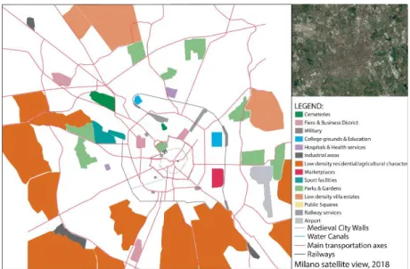
In order to define fringe belts in the city, a revision of the subject and a comparative map analysis was conducted. Milan’s urban growth and development was observed by overlapping city maps from different periods of urban growth, accordingly to the imperatives of the work of Conzen and Whitehand, the transformation and alienation process in the city of Milan was investigated. Data collection and analysis of these data were used as a base method in this research. The study concentrates among several land use patterns that are linked to the fringe belt land utilization (according to Conzen studies): cemeteries, military areas, college grounds, hospitals, industrial areas, marketplaces, sports and recreation areas, vast squares, parks and gardens, low density villa estates, airport areas and low density residential areas with agricultural character, known as “cascinas” (Figure 1). Not far from the city center, example of rural life dating to eighteenth century could be found - urban farmsteads, originally called “Cascina” in Italian consisted of residential farmhouse made up of series of individual dwellings and vast areas of gardens and courtyards, used to occupy the rural periphery of the city, so identified as low density residential areas with agricultural character within the map analyses. Many of the original Cascina structures, once abandoned, were completely destroyed, thus their land was integrated to the contemporary developments of the city, whereas some underwent extensive renovation and today act as historical social centers, completely surrounded by modern constructions (Cascina Cuccagna in Porta Romana, for instance). However, some cascinas maintained their original functions as urban agricultural lands and take place mostly in the periphery of the dense urbanization sites, recently.
0/ IC O N ARP. 20 18 .56 – E -I SSN : 21 47 -9380
In addition, urban land use character that exceptionally specified in the case of Milan was distinguished: former fair grounds that used to take place in the outskirts and lately integrated within the city, transforming into commerce areas due to capitalism market forces and carry the features of business centers after the 40s of the previous century arose rapidly. Although being enveloped and adopted within residential districts, subsequently, these grounds tend to preserve strong distinguishing architectural and typo-morphological nature, recently, that highly differentiate them from their surrounding environments (indicated as “Fiera & Business District” in the 1937, 1964 and 2018 map analyses). For instance, Republica district, Porta Nuova and City Life are related examples of that type of urban developments that lately show consolidation properties as central business district in the recent urban structure of Milan, but after all differ from their enclosing residential districts.
The research methodology concerns a comparative study of various city plans corresponding to significant urban transformation periods, starting from 1840 until 2018. A consistent overlapping of maps resulted in urban growth pattern and land use transformation analyzes that relate to the formation and modification of the fringe belts of the city. The following consecutive map overlapping have been taken into consideration: · New Plan of the City of Milan, corresponding to 1840
· Milan Master Plan, 1877 · Milan Master Plan, 1904 · Milan Master Plan, 1937 · Milan Master Plan, 1964 · Milan satellite view, 2018
Figure 1.Indication of land use patterns in the following map
analyzes (prepared by the
authors)
- V olu m e 6, Is su e 2 / Pu bli shed : D ecemb er 20 18
Data collection is consisted of supply of historical and current plans from relevant databases, visual documents and old photographs, comparison of historic maps with consecutive plans and documents. Land use analysis was conducted to understand land utilization manners and their transformation, due to economic either political forces.
HISTORICAL LAYOUT, URBAN FORM AND DEVELOPMENT OF MILAN
“The historic development of Milan and the making of the city is rather complicated, due to an amount of different phases and stratifications, from ancient times to the current days: there is a Roman Milan, a Middle age Milan, a Renaissance Milan, a Spanish Milan, a XIX century city (Beruto’s plan) and a great recent development, what generally occur in all European cities, and in Italy in particular” (V. Cutini, 2018). Mediolanum (the Roman name of Milan) was established in 222 BC, as a “roman castrum” that became a part of the state of the Caesars. Its location on the junction of strategic axes defined its preliminary destiny to expand and gain status quo an important exchange center. The first "castrum walls", which surrounded a square of about 600 meters of side, were replaced, during the imperial age by new walls 3.5 Km long of irregular geometrical shape (GeDeA, 1995). Under the Constantine’s rule, the city expanded beyond its primary medieval walls and spread along secondary perimeter walls, containing several public and cultural facilities within its core (theaters, temples and basilicas). Once completely destroyed, the walls were reconstructed again in 1176 and six urban gates were defined to control the permeability and frame the “indoor” and “outdoor” of the city. At the same time the “Naviglio Grande” (vast water canal) construction under the Azzone Visconti rule has already started, which aimed to create a net of water roads with great defense hydraulics system around the urban wall. In 1330, Visconti gained the title “Dominus Generalis” and Milan became the capital of the state. The walls were reinforced and the construction of the Castle (Figure 2) was initiated (1368), the church of Saint Tecla was demolished to allow the establishment of the Duomo Cathedral (1386) – the most emblematic signature of the city, well known recently (Figure 3). In the period of 13th-16th century, Milan showed strong character of a medieval city with a powerful separation of urban-rural land pattern. The primary castle wall, outlined the basic formation of the core urban specimen, acting as a fixation line, it fostered the embodiment of the ring shaped secondary city wall that acted as a main defense structure.
0/ IC O N ARP. 20 18 .56 – E -I SSN : 21 47 -9380
In the period of 17th – 19th century, Milan steadily gained a rise in its population due to socio-economic factors that attracted merchants and crafts men who laid the fundamentals of the future economic development of Milan as an industrial center. As a result, the inner city agricultural land was transformed into residential areas, where only ‘citizens’ had the opportunity to inhabit. However, a definite preservation of the city core within
the castle walls was observed, which hosted the main administrative facilities related to the city console. The processes of land utilization did not show a rapid transformation until 19th century. Industrialization and mechanization of the economic power acted as a catalyst for further city expansion and continuous population growth.
Figure.2..Sforzesco.Castle
(Alessandrofoto)
Figure.3..Duomo.di.Milano (Giacomo Brogi)
- V olu m e 6, Is su e 2 / Pu bli shed : D ecemb er 20 18
The city of Milan is a good instance to explain the context of European and Italian modernity. In the 19th century Milan experienced a period of greatness; the city became an important pole of the Enlightenment. In the 1796 Napoleon Bonaparte expelled the Austrians, the city was ruled by the French and became the capital of the Cisalpine Republic, until the 1799. Among the main urban-neoclassical works, it was the conversion of the Castle walls that had a big importance in the urban context of Milan. The old city walls were destroyed and replaced by panoramic walks of the forecasted “Foro Buonaparte” - semi-concentric rings that surround piazza Castello (the Castle square), and private houses were transformed to refined monuments.
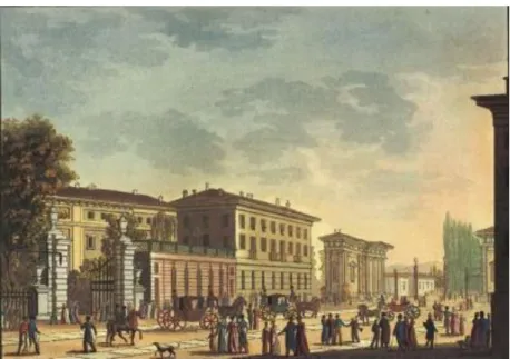
After the Napoleone fall, the plan wasn't carried out, thus only after the Austrian Restauration (1814-1859), new transformations started with the rebuilding of many streets and new axes, privileged by location and morphology, where new districts were born, identified today by large number of neoclassical buildings. In this sense, fundamental changes were made in the area of “Porta Orientale” (today “Porta Venezia”) - the “Corso Venezia” axis (Figure 4) was a privileged work as it was the main connection line to Vienna, Austria. The transformation of the urban texture contributed to the design of the first public garden within the city: “Giardini di Porta Venezia” (The Gardens of Porta Venezia (Fig.6 (1)).
The competition (1861-1862) to adjust Piazza del Duomo with the Vittorio Emanuele Gallery (1865-1878), won by Mengoni, set up the style of the iconic monumental urban place. Nevertheless, the emerging transportation problem led to the implementation of a railway system - both the Milano Centrale (Figure 5) and Porta Genova railway stations’ construction started in 1864. In the end
Figure 4. Corso Venezia,
Illustration (online archive)
312
0/ IC O N ARP. 20 18 .56 – E -I SSN : 21 47 -9380
of 19th century, Milan underwent a new period of industrialization and progress with the bourgeoisie. This social class created new districts characterized by a new style: the liberty.
FRINGE BELT FORMATION AND TRANSFORMATION IN MILAN
The unification of Italy (1870) and industrialization period of the 19th century let to expansive population and urban growth, which related to the expansion of the city borders and transformation in its land use character, and a decline of the agricultural lands. Despite the decadence of the wall function, the vigorous temper of the medieval city wall acquired its role as a ring-shaped fixation line that outlined the further urban expansion.
Expansion of Milan in The end of 19th Century. The Beruto
Plan (1884-1889):
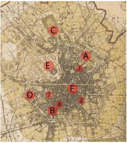
The city of Milan expanded vastly and transformed as a result from The Beruto Plan (Figure 6) – the first masterplan, especially contributing to the transformation of the city center, at that time still enclosed within the Spanish walls (1549-1560), which resembled as a place to represent the ideas of emerging Milanese bourgeoisie. Compared to the Napoleonic plan (1807), Cesare Beruto – main architect and chief engineer of the city, used “cautious and modest plan” techniques to express an international vision of the predicted expansion of the city. The new masterplan aimed to regulate the urban development and structure the growth beyond the Spanish walls, which experienced a complete demolishing processes (except in some limited partitions). The first signs for the urban growth were indicated by high integration and immersion of educational plots (ex: Universita Catolica (Fig.6 - 2), Universita degli studi di Milano (Fig.6 - 3)), religious temples (ex: Basilica di San Lorenzo (Fig.6 - 4)) and cultural grounds Figure 5.Stazione Centrale,
Milan Central Station (online
archive)
- V olu m e 6, Is su e 2 / Pu bli shed : D ecemb er 20 18
(theaters and other institutions), which were situated in the internal perimeter of the castle (Spanish) walls, embedded within the newly establishing residential areas, diffusing the borders of the primary fixation line (the castle walls), by that time would be analyzed as primary fringe belt areas. However, the vast urbanization and population growth, let to the translation of high density residential areas that surrounded the historical core, thus fully integrated those grounds into the texture of the residential districts. Despite the decadence of the wall function, the vigorous temper of the medieval city wall acquired its role as a ring-shaped fixation that outlined the further urban expansion. In addition, the plan concentrated on the multiplication of main transportation axes that connected the historic city core with the outlying districts, thus required for the implementation of an inner ring road pedestrian walkway, similar to the Vienna ring road saturated with parks, gardens, services and facilities, which mostly took place along the footprint of the once existing wall. Nevertheless, several key urban facilities for the further expansion of the city were founded: the first railway stations (Stazione Centrale (Fig.6 (A) and Porta Genova Fig.6 (B)), the monumental cemetery Cimitero Monumentale (Fig.6 (C)) and San Vittore (Fig.6 (D)) prison were established. The vast increase of inhabitants marked the begining of significant tranformation within the city fabric in the last two decades of the 19th century, becoming the second largest city in Italy in terms of population. The structure that ordered the urban fabric was represented by the street grid (city blocks initially about 200 metres in the first version of the plan from 1884, were halved to “real estate size” with the approved version of 1889), which consolidated the forma urbis inherited from history, comprising radial roadways converging towards the city centre and concentric ring roads (Galuzzi & Vitillo, 2017). The most evident portion of the Beruto plan concentrated on a “donut” like expansion, which varied in depth, between the Spanish walls and a new outer ring road that aimed to unite the few already developed areas beyond the walls. Another fundamental part of the Manifesto was the elongation of a north-west transportation artery that was generated by the extended area of the Castle and the newly designed Parco Sempione park (Fig.6 (E)), passing through Piazza del Duomo and the Galleria (Fig.6 (F)), it directed to the south-east to create a continuous axis, which required the demolishing of a limited portion of the urban fabric and renovation of few to reorganize a new urban system in the historical district. The transformation of the city center led to a process of decrease in the population and pulverization of its poorest parts. Moreover, 70s brought a slow process of redevelopment in the office sector and formation of CBD (new buildings for banks, insurance companies, large
0/ IC O N ARP. 20 18 .56 – E -I SSN : 21 47 -9380
national enterprises and trade), which involved the incorporation of new urban segments within the center of the city.
The unification of the state brought about a dynamic economic uplift, which called for wider local and regional mobility and initialized the construction of bounding network with north-west Europe. Milan relied on the development of good public transportation, and implementation of local and international railway system, which gave the importance of the city as a major national rail center for passengers and freight. “In an ever-increasing fashion, railways became the backbone of the transport system, progressively marginalising the network of waterways that up until the middle of the nineteenth Century had complemented the system of transporting goods by land” (Galuzzi & Vitillo, 2017).
Transformation of Milan from Late 19th until 21st Century:
The initial map analyses aims to indicate a primary morphological growth pattern of the city, by comparing its urban formation in the period 1840-1877 – just before the realization of the Beruto’s Plan (1884-1889). The following analytical approach intends to study the consecutive development patterns of Milan by comping its expansion tendency after the approval and application of the Beruto’s masterplan and overlap land use data analyses from succeeding years (1904, 1937, 1964, 2018).
Figure 6. Beruto Masterplan
1884-1889. We can see the body of the existing city (darker within the Spanish walls), and the ring of the zone of extension (the circle clearer outside the walls, with the new roads (prepared by the
authors)
- V olu m e 6, Is su e 2 / Pu bli shed : D ecemb er 20 18
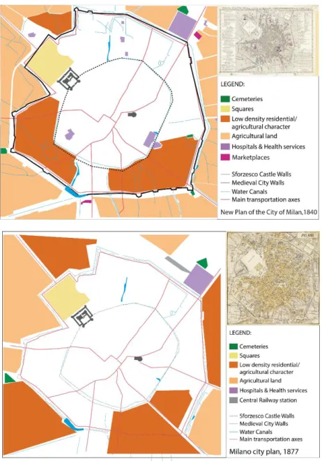
“The new plan of the city of Milan, corresponding to 1840” (Figure 7) defined several fundamental transportation axes that linked the historic city core with broader peripheries. There is a steady process of urbanization of the surrounding the city wall structure territories. Inner agricultural land has been transformed to low density residential areas that particularly preserve their agricultural characteristics (“cascinas”). The agricultural land has been translated only around the city boundaries, and the allocation of public services as hospitals and marketplaces prognosticated the forthcoming expansion process of Milan.
Milan Master plan, 1877 (Figure 8) - the second half of the 19th
century has been characterized by industrialization and mechanization of the work forces that resulted in a vast population growth and urbanization processes in Milan. The old city walls have been established as inner transportation rings that lost their “border” properties and a vast transformation to high
Figure 7.Graphical representation of land use, 1840; Top-right corner: Milan map, 1840
(prepared by the authors; Milan map: online archive )
Figure.8..Graphical representation of land use, 1877; Top-right corner: Milan map, 1877 (prepared by the
authors; Milan map: online archive )
0/ IC O N ARP. 20 18 .56 – E -I SSN : 21 47 -9380
dense residential areas has been initiated. Moreover, the city lost its agricultural land in the periphery, and converted to low dense residential areas. Dynamic urbanization led to the modification of natural water sources into urban canals, or direct restraint interventions. The initiated construction of the Central Station and integration of railway services encouraged faster land utilization in the Northern part of the city.
Milan Master Plan, 1904 (Figure 9), defined new land use patterns within the urbanized territories that aimed to provide the city with higher hygiene and better living quality. The implementation of green areas within the residential parts has been a definite new strategy for a continuously increasing urbanization and economic power of Milan and Lombardy region. The completion of several new regional railway stations and extension of the railway system has showed the need for better transportation connection within and outside of the city. The integration of residential lands within the urban fabric resulted in further loss of agricultural territories.
Milan Master Plan, 1937 (Figure 10), defined a clear North-East urban expansion of the city. Broader land utilization led up to the formation of new high density habitations that required broader service distribution around the peripheral territories, such as sports fields and educational grounds. The allocation of market places and fair grounds aimed to disperse the economic power within various parts of the city. A wider transportation network that connected the city core with surrounding industrial areas has been implemented.
Figure.9..Graphical representation of land use, 1904; Top-right corner: Milan map, 1904 (prepared by the
authors; Milan map: online archive )
- V olu m e 6, Is su e 2 / Pu bli shed : D ecemb er 20 18
Milan Master Plan, 1964 (Figure 11), defined new administrative border of the city that linked with upcoming satellite settlements on a Municipal level. The wide spread cascina settlements around the periphery of the city turned to small agriculture- production lands that contributed in low dense residential habitations. There is a strong translation of the industrial sector to service branch that assigned a new economic structure within the city borders. Industrial areas have been allocated and concentrated mainly on the surrounding Northern satellite cities of Milan, and largely engaged with textile and manufacturing. A strong differentiation of the Southern land utilization was visible, where mainly agricultural forces were embodied.
Milan satellite view, 2018 (Figure 12), indicates the recent land use distribution within the Municipality of Milan that linked to strong transportation network to the North where the spatial extension is clearly directed. There is a strong collision between North (urban) and South (rural) that present different dominant characters of industrialization and mobility network (Bergamo and Malpensa airports) of the North-west, and low density rural areas that tend to show agricultural features to the South. The Northern expansion of the city is related to the attempt for good
Figure.11..Graphical representation of land use, 1964; Top-right corner: Milan map, 1964 (prepared by the
authors; Milan map: online archive ) Figure 10.Graphical representation of land use, 1937; Top-right corner: Milan map, 1937 (prepared by the
authors; Milan map: online archive )
0/ IC O N ARP. 20 18 .56 – E -I SSN : 21 47 -9380
network connection with Northern European countries such as Switzerland, Austria and Germany. As usually concerned, the growth of the city currently is based upon socio-economic and political strategies of the urban planning principles of the city council since the beginning of 20th century.
THE IDENTIFICATION OF MILAN’S FRINGE BELTS
Consistent land use indicating maps follow a comparative analysis of land utilization changes and fringe belt modifications within defined morphological periods in order to outline a general framework of the fringe belts of Milan. Land use map overlapping represents a consecutive map overlapping of land -use indicator schemes in successive time-lapse count that resulted in graphical representation of lands use transformations, defining five morphological periods and several fringe belt processes during city’s expansion (Figure 13).
The First Morphological Period: 1840-1877:
1840-1877 Fringe Belt-Land Use Maps Overlapping (Figure 14) resulted in defining the castle wall as a primary fixation line and the city-gate wall as the secondary fixation line, characterizing the land utilization beyond with low density residential areas with agricultural features, agricultural lands, hospitals, cemeteries and a vast public square attached to the main administrative unit of the city. In the period, a loss of agricultural lands and their transformation to mainly low density residential areas yet with Figure.12..Graphical representation
of land use, 2018; Top-right corner: Milan satelite view, 2018 (prepared
by the authors; Milan map: Google Earth)
Figure 13.Indication of land use
transformations from the
consecutive map overlapping analyzes in Fig. 15, 17, 19, 21, 23
(prepared by the authors)
- V olu m e 6, Is su e 2 / Pu bli shed : D ecemb er 20 18
strong agricultural characters (“cascinas”) resulted in fringe belt alienation (Figure 15).
Figure.14..Graphical representation, indicating land use.Map overlapping: 1840-1877 (prepared by the authors)
Figure.15..Graphical representation indicating land use transformation as a result from the 1840-1877 map overlapping (prepared by the authors)
320
0/ IC O N ARP. 20 18 .56 – E -I SSN : 21 47 -9380
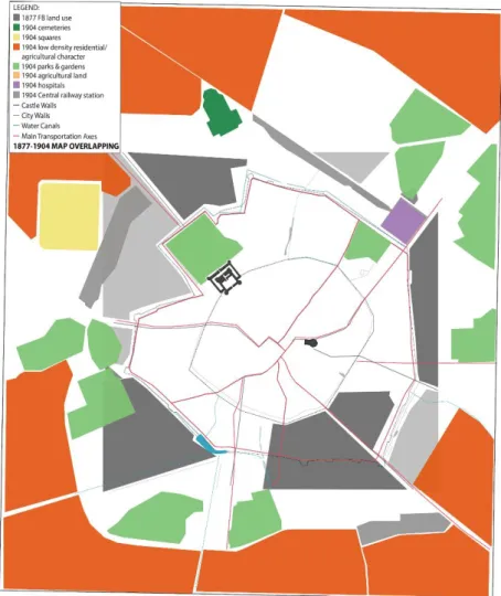
The second morphological period: 1877-1904:
1877-1904 Fringe Belt Land Use Overlapping (Figure 16) declared the preservation of a constant character of primary (castle wall) and secondary (gate wall) fixation lines, and a land utilization pattern characterized by low density residential areas with supporting agricultural characters, expanding agricultural lands, definition of new parks and gardens, hospitals and cemeteries, maintenance of a public square with administrative feature. Land use modifications are observed in the translation of low density to higher density residential districts. Fringe belt alienation is defined by the loss of agricultural lands and their transformation to low density residential areas. Fringe belt consolidation process is tracked with the implementation of railway services and the formation of the Milan Central station district. Fringe belt translation within new green areas and parks is observed (Figure 17).
Figure 16.Graphical representation,
indicating.land.use..Map overlapping: 1877-1904 (prepared by the authors)
- V olu m e 6, Is su e 2 / Pu bli shed : D ecemb er 20 18
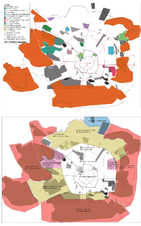
The Third Morphological Period: 1904-1937:
1904-1937 Fringe Belt Land Use Overlapping (Figure 18) resulted in the affirmation of the primary fixation line (the city wall), but defined new secondary fixation line, formed by the newly established transportation/railway ring. Land utilization characterized with low density residential districts, agricultural lands, hospitals, cemeteries, parks and recreational areas with sports features, military areas, industrial areas, marketplaces, college grounds and low density villa estates. Land use modification from low to high density residential areas as well as fringe belt alienation in the loss of agricultural lands is noticed. Consolidation of the Southern low density residential areas and Southeast Marketplaces is marked. Strong fringe belt translation processes in the fair district and business areas are defined (Figure 19).
Figure.17..Graphical representation indicating land use transformation as a result from the 1877-1904 map overlapping (prepared by the authors)
322
0/ IC O N ARP. 20 18 .56 – E -I SSN : 21 47 -9380
The Fourth Morphological Period: 1937-1964:
1937-1964 Fringe Belt Land Use Overlapping (Figure 20) defined vast expansion and new primary fixation line - the transportation/railway ring and a secondary fixation line - a new administrative boundary of the great city of Milan. Land utilization pattern preserved constant features. Land use modifications are mainly concerned from low density to high density residential areas, alienation is consisted of loss of agricultural lands that are transformed into low density residential areas. Fringe belt consolidation is observed within the educational district Citta studi of Milan, some recreation and sports areas. Fringe belt Figure.18..Graphical representation,
indicating land use.Map overlapping: 1904-1937 (prepared by the authors)
Figure.19..Graphical representation indicating land use transformation as a result from the 1904-1937 map overlapping (prepared by the authors)
- V olu m e 6, Is su e 2 / Pu bli shed : D ecemb er 20 18
translation in the Northern industrial part of the city could be observed (Figure 21).
The Fifth Morphological Period: 1964-2018:
1964-2018 Fringe Belt Land Use Overlapping (Figure 22) defined consolidation features of the primary (railway ring) and secondary (administrative boundary) fixation lines. Land utilization is concerned with low density residential areas that preserve agricultural characters (“cascinas”), agricultural lands, hospitals, cemeteries, parks and gardens, recreation, sports and military areas, a strong stratification of industrial areas and marketplaces, emerging college grounds and low density villa estates. Land use modification resulted in low-mid to high density
Figure 20.Graphical representation,
indicating land use.Map
overlapping: 1937-1964 (prepared
by the authors)
Figure 21. Graphical representation
indicating land use transformation as a result from the 1937-1964 map overlapping (prepared by the
authors)
0/ IC O N ARP. 20 18 .56 – E -I SSN : 21 47 -9380
residential districts. Alienation in loss of agricultural lands and their transformation to urban settlements is observed. Fringe belt consolidation of the Northern industrial area and Northern commerce&business district is distinguished. Fringe belt translation of the Southern fair district, North-west industrial area and villa estates is noticed (Figure 23).
Figure 22.Graphical representation,
indicating land use.Map
overlapping: 1964-2018 (prepared
by the authors)
Figure 23. Graphical representation
indicating land use transformation as a result from the 1964-2018 map overlapping (prepared by the
authors)
- V olu m e 6, Is su e 2 / Pu bli shed : D ecemb er 20 18 FURTHER ASSUMPTIONS
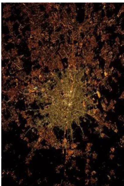
Recently, a strong differentiation between the Northern and Southern urbanization gradient is evident (Figure 24): the highly dense urbanized North direction to Northern satellite settlements aims stronger linkages with industrial areas and Northern European countries, resulting in densification of economic bonds. In addition, constant expansion to the North attempts good mobility and service network with the industrial satellite settlement of the Greater Municipality of Lombardy. In comparison, a lower density urbanization to the South and maintenance of the Southern agricultural land is observed.
CONCLUSION
The methodological research resulted in general perspective of fringe belts identification and delineation in Milan and defined urban elements with strong morphological characteristics within the city structure: the old castle walls of the historical city, playing the role of powerful fixation lines acted as control lines of dynamic land use transformations that resulted from strong industrialization and economic forces and led to great urban territory growth and boundary expansion of the contemporary metropolitan area (The Great Municipality of Milan).
As a result, the city of Milan derived the formation of three types of fringe belts (Figure 25). The Inner fringe belt (IFB), closest to the primary fixation line (the secondary city walls (II.)), recently, consists of former fair grounds, cemeteries, college grounds (Citta Studi), marketplaces, city parks and gardens. The Middle fringe belt (MFB) is characterized by low density residential areas, villa estates, sports and green recreational areas, Linate Airport, which
Figure 24. Satellite night view,
indicating a strong North direction of urbanization gradient in Milan
(NASA)
0/ IC O N ARP. 20 18 .56 – E -I SSN : 21 47 -9380
is the closest to the city, hospital grounds and health service areas, and the Outer fringe belt (OFB) comprises low density residential areas with agricultural characters (“cascinas”), villa estates, industrial zones, municipal parks with natural forestry and satellite settlements (Great Municipality of Milan).
Milan’s fringe belts composition as part of the texture of the built environment tends to show integrative properties to the overall urban system. In spite of being different in their consistency and scale proportions, compared to the tightly built-up residential and commercial areas, the fringe belt characteristic land uses adapt to the natural morphological expansion of a city with dynamic historical background. The inner fringe belt has undergone tremendous modifications, because of strategic economic considerations, and recently has strong consolidation properties defining mainly important university grounds and distinguishing commerce (business) district, concerning continuous developments, resulting from the technological evolution and formation of a strong service industrial sector in Lombardy region that have powerful economic and political importance for the whole country.
In addition, a discussion on the positive contribution of the natural outer green fringe belts areas in Milan is introduced. The outer natural green areas, as remainders of the fringe belts modifications, are important and necessary to better the quality of urban life as they provide ecological habitat to maintain the Figure 25.Graphical representation,
indicating recent fringe belt
- V olu m e 6, Is su e 2 / Pu bli shed : D ecemb er 20 18
natural systems in otherwise dense built-up concrete environment. In this sense, the Middle and Outer fringe belt of Milan tend to rinse their borders in particular areas and leisure and natural sports grounds play crucial role for the rehabilitation of the social life and the proper operation of the whole urban organism. For instance, West and South-West green areas preserve not only the original ecosystem characteristics on regional scale, but also comprise strong recreational properties and medium for deferred authorship design, as a device for the articulation of public forces in the landscape shaping (Figure 26). The Boscoincita, literally translated “the forest in the city”, the Aldo Aniasi, Parco della Cave and Romano Bianco parks to the West, are not only part of important ecosystem corridors, but also generate the sense of social belonging and responsibility among the authorities for the preservation of the ecological heritage and
induce participation in land treatment and urban agriculture. Beyond their recreational features, fringe belt zones could also show fundamental properties for food supply for the communities. Parco Agricolo Sud Milano in the South-West, for instance, plays the role of an integrated urban farming medium and a buffer zone between surrounding urban system (in this case the city of Pavia). In this regard, fringe belts are important for the clear framing and differentiation of one urban structure from another. Being present in limited quantity, the green areas to the North-West are natural filtration zones that protect against the harmful influences of the surrounding industrial realms, but tend to be insufficient for the
Figure 26.Graphical representation,
indicating recent fringe belt formation (prepared by the authors)
328
0/ IC O N ARP. 20 18 .56 – E -I SSN : 21 47 -9380
formation of an overall connected green belt system that envelopes the city and contributes to the creation of integrated urban ecological corridor, thus improve the life habitat of the community and natural systems.
Whereas the initial fringe belt formation of Milan has been linked to industrialization and vast urbanization that resulted in city expansion, the recent urban development is related to dynamic economic forces and translation of powerful service sector that aims to respond to the socio-economic and technological needs of the contemporary society. Milan’s transformation to financial center of Northern Italy and vast development of the Northern urban land in the last two decades sacrifices natural green grounds in the aim of implementation of strong infrastructural and economic bonds with Northern Europe.
Recognition of the characteristics of fringe belts and their framing considering existing fixation lines into a regulated conceptual matter within the city, can both contribute to urban landscape management and urban planning policies with environmental consciousness when it comes to preservation of original morphological characteristics of the city, and adequately adapt new inevitable urban developments under current socio-economic circumstances. Moreover, they could benefit the touristic potential of Milan, thus shift from well-known shopping to increasing cultural and leisure attitude towards its visitors.
REFERENCES
Albergoni, G. (2006). “I Mestieri delle Lettere tra Istituzini e Mercato. Vivere e Scrivere a Milano Prima Meta dell’Ottocento”, Milano: Franco Angeli.
Bigatti, G. (2000). “La citta operose. Milano nell’ottocento”, Milano: Franco Angeli.
Boriani, M., Rossari, A., Rozzi, R. (1993). “La Milano del Piano Beruto (1884 – 1889). Società, urbanistica e architettura nella seconda metà dell’800”, Milano: Guerini e Associati. Carozzi, C. (1993). “La crescita urbana dall’Unità ad oggi, in
Storia illustrata di Milano”, vol. 7.
Christine, P. (2009). “Inventing Futurism: The Art and Politics of Artificial Optimism”, Princeton University Press.
Conzen, M. R. G. (1969). Alnwick, Northumberland: a study in town-plan analysis Institute of British Geographers Publication 27, 2nd edn (Institute of British Geographers, London).
Conzen, M.R.G (2004), “Thinking about urban form. Papers on urban morphology, 1932-1998”, Bern: Peter Lang AG
- V olu m e 6, Is su e 2 / Pu bli shed : D ecemb er 20 18
Conzen, M. P. (2009). “How cities internalize their former urban ringes: a cross-cultural comparison”, Urban Morphology13, 29-54
Costa, S.A.P., Machado,K. (2017). “A study of fringe belts in Belo Horizonte, Brazilia contribution to developments in urban morphology”. In G.Strappa (Ed.), Observations on Urban Growth, pp.17. Milan: Franco Angeli.
Cutini, V., Farese, D., Rabino, G. (2018). “Milan: The Configuration
of Metropolis”, In R. Papa, R. Fistola, C. Gargiulo (Ed.),
Smart Planning: Sustainability and Mobility in the Age of Change, pp.343-357. Springer International Publishing AG, part of Springer Nature 2018
Finetti, G. (2002). “Costruzione di una città”, Milano: Ulrico Hoepli Editore.
Galuzzi, P. and Vitollo, P. (2017). “Milan and the Unification of Italy”, “Itineraries through Milan’s architecture: Modern architecture as a description of a city”, Fondazione dell’ordine degli Architetti, Planificatori, Paesaggisti e Conservatori della provincial di Milano.
GeDeA, de Agostini (1995). Guida Grande enciclopedia De Agostini . Novara: Istituto Geografico De Agostini. Gu, K. (2010). “Exploring the fringe belt concept in Auckland: An
urban morphological idea and planning practice”. New Zealand Geographer 66, 44- 60.
Hazar, D. Kubat, A.S. (2005). “Fringe belts in the process of urban planning and design: Comparative analyses of Istanbul and Barcelona”, ITU A,Z issue Vol 12, No 1,53-65.
Hazar, D., Kubat, A.S. (2015). “The fringe belt development process of Istanbul”, 23rd International Seminar on Urban Form (ISUF) 2015, Conference proceedings, 423-436, Nanjing, China.
Kubat, A.S., Hazar, D. (2018). İstanbul’un Çeper Kuşak Gelişim Süreci, Local ISUF Congress on Urban Morphology, İstanbul Technical University, İstanbul, Turkey. (proceedings forthcoming)
Kubat A.S. (2018). “Exploring The Fringe Belt Phenomenon In TheCase Of Istanbul”, CyNUM 2018, Cyprus Network of Urban Morphology, Plenary Session (invited speech), Cyprus.
Lammers, D. G. O., Roders, A. R., & van Wesemael, P. J. V. (2017). “Post-industrial Eindhoven and its radial fringe-belt: a morphology of contemporary urban growth”. In G. Strappa (Ed.), Observations on Urban Growth, pp. 15-50. Milan: Franco Angeli.
Louis, H. (1936). “Die geographische Gliederung von Gross- Berlin”, in Louis, H. and Panzer, W. (eds) Länderkundliche
0/ IC O N ARP. 20 18 .56 – E -I SSN : 21 47 -9380
Forschung: Festschrift zur Vollendung des sechzigsten Lebensjahres Norbert Krebs 146-71, Engelhorn, Stuttgart. Ünlü, T. (2018). "Urban Growth of Turkish cities", inObservations
on Urban Growth, ed: Giuseppe Strappa, Dep. of Architecture and Design, (Diap) sapienza University, Rome, 173-189.
Venuti, G. C. (1986). Un secolo di urbanistica a Milano.Milano: Clup Press.
URL-1 http://www.stagniweb.it
URL-2 http://geoportale.comune.milano.it URL-3 http://www.pim.mi.it/pgtonline/
Whitehand, J.W.R. (1987). “The changing face of cities: a study of development cycles and urban growth”. Blackwell, Oxford. Whitehand, J. W. R. and Morton, N. J. (2003). “Fringe belts and the
recycling of urban land: an academic concept and planning practice”, Environment and Planning B: Planning and Design 30, 819-39.
Whitehand, J.W.R. and Morton, N.J. (2004). “Urban morphologyand planning: the case of fringe belts”, Cities 21, 275‐89.
Whitehand, J. W. R. and Gu, K. (2017). “Urban fringe belts: evidence from China”, Environment and Planning B: Urban Analytics
and City Science 44, 80-99.
Resume
Dzheylan Safet Karaulan is MSc student in Urban Design in Istanbul Technical University, Istanbul, Turkey. She got her B.Sc. degree in Architecture at Faculty of Architecture, Urban Planning and Construction Engineering at Politecnico di Milano, Milan, Italy in September 2015. She is currently obtaining her MSc in Architecture in University of Architecture, Civil Engineering and Geodesy in Sofia, Bulgaria. She enrolled in MSc in Urban Design in Istanbul Technical University in 2017 and her recent research interests are Resilience Planning and Design Strategies and their adaptation to the urban form and growth. She worked as an intern in architecture and construction offices in Sofia, as well as coordinated a restoration project in Ohrid, accepted by the Ministry of Culture in Macedonia in 2017.
Dr. Ayşe Sema Kubat has degrees of B. Arch and M. Arch and PhD in Urban Design & Urban Planning from Istanbul Technical University (ITU). She is currently working as a Professor at the Faculty of Architecture, Department of City and Regional Planning of ITU. She has been serving on the Steering and Refereeing Committees of the Space Syntax Symposiums since 2003, and was the chair of the 6th International Space Syntax Istanbul Symposium in June, 2007. Her assistance and cooperation to the research project entitled 21st Centre of Excellence for Sustainable Urban Regeneration (cSUR) (2003- 2008) is appreciated as “Honorary Fellow of Global Center
- V olu m e 6, Is su e 2 / Pu bli shed : D ecemb er 20 18
of Excellence’’ at Tokyo University. Dr. Kubat is the chair of the Turkish Network of Urban Morphology and the chair of the 2nd Local Conference of the Network at 2018 at ITU, İstanbul.