BURIAL CUSTOMS OF CLAZOMENAE IN THE IRON AGE (1100 – 500 BC) A Master’s Thesis by POLAT ULUSOY Department of
Archaeology and History of Art Bilkent University
Ankara January 2010
BURIAL CUSTOMS OF CLAZOMENAE IN THE IRON AGE (1100 – 500 BC)
The Institute of Economics and Social Sciences of Bilkent University by POLAT ULUSOY
In Partial Fulfillment of the Requirements for the Degree of MASTER OF ARTS in THE DEPARTMENT OF
ARCHAEOLOGY AND HISTORY OF ART BILKENT UNIVERSITY
ANKARA January 2010
I certify that I have read this thesis and that it is fully adequate, in scope
and quality, as a thesis for the degree of Master of Arts in Archaeology and History of Art. ... Dr. Charles Gates Supervisor
I certify that I have read this thesis and that it is fully adequate, in scope
and quality, as a thesis for the degree of Master of Arts in Archaeology and History of Art. . ... Dr. Jacques Morin
Examining Committee Member
I certify that I have read this thesis and that it is fully adequate, in scope
and quality, as a thesis for the degree of Master of Arts in Archaeology and History of Art. ... Dr. Yaşar E. Ersoy
Examining Committee Member
Approval of the Institute of Economics and Social Sciences
... Prof.Dr. Erdal Erel Director
ABSTRACT
THE BURIAL CUSTOMS OF CLAZOMENAE IN THE IRON AGE (1100 – 500 BC)
Ulusoy, Polat
M.A, Department of Archaeology and History of Art Supervisor: Dr. Charles Gates
January 2010
The present work is a study on the burial customs of Clazomenae in the Iron Age and Archaic period. Special attention is given to Clazomenae, since it yielded significant information from the Protogeometric to the end of the Archaic period. The major aim here is to collect the specific grave and necropolis information and try to interpret them for reaching more holistic conclusions about the burial customs of Clazomenae. This work introduces the burials, burial grounds, and cemeteries of Clazomenae from the Protogeometric to the end of the Archaic period with respect to grave types, grave goods, burial practices, gender, and age. One crucial aim of this work is to understand settlement and necropolis relationship in different periods by the means of the location of the burial grounds; the significance of the extension, development, and changing burial customs of specific cemeteries and their importance with regards to the settlement pattern; and the importance of the continuity, discontinuity, and change of burial grounds through the periods.
Keywords: Clazomenae, burial customs, necropolis, Protogeometric, Geometric,
ÖZET
CLAZOMENAE'DE DEMĠR ÇAĞI ÖLÜM GÖMME GELENEKLERĠ (1100 – 500 BC)
Ulusoy, Polat
Yüksek Lisans, Arkeoloji ve Sanat Tarihi Bölümü Tez Yöneticisi: Dr. Charles Gates
Ocak 2010
Bu çalışma Clazomenae kentinin Demir Çağları ve Arkaik dönemdeki ölü gömme geleneklerini incelemektedir. Tez kapsamında Clazomenae kentine öncelik verilmesinin nedeni kentin Protogeometric dönemden Arkaik dönemin sonuna kadar yoğun bir bilgiye sahip olmasıdır. Burada temel amaç, mezar ve mezarlıklardan bilgileri toplayıp ve derleyip, Clazomenae ölü gömme gelenekleri için daha genel ve kapsayıcı bir sonuca ulaşmaktır. Çalışma, Clazomenae’de Protogeometrik dönemden Arkaik dönem sonuna kadar açığa çıkarılmış mezar, mezarlık alanları ve nekropolleri mezar tipleri, pratikleri, hediyeleri, yaş ve cins açısından tanıtacaktır. Çalışmanın en önemli amacı farklı dönemlerdeki kent ve mezarlık ilişkisini; mezarlıkların konumu; belirli mezarlıkların yayılımı, gelişimi ve gömme geleneklerinin değişimi; bunun yerleşim yapısındaki etkileri; mezarlıkların devamlılığı, devamsızlılığı ve değişiminden yola çıkarak anlamaya çalışmaktır.
Anahtar Kelimeler: Clazomenae, gömme gelenekleri, mezarlık, Protogeometrik,
ACKNOWLEDGEMENTS
The burial customs of Clazomenae have been studied by many colleagues and scholars in many aspects and in detail. This study should be seen as the holistic interpretation and discussion of these studies. Moreover, recently discovered intramural and extramural burial grounds dated to the Protogeometric, Geometric, and Archaic periods have been added to this study.
The subject of this MA thesis was suggested to me by Assoc. Prof. Dr. Yaşar E. Ersoy, director of the Clazomenae excavations. I am endlessly grateful to my advisor and professor Dr. Ersoy for recommending to me such an interesting subject for discussing and interpreting. I am also grateful to Dr. Ersoy who let me benefit from his experience and for the patience, unlimited support, and advice that he has given me as my advisor and teacher. The photographs and finds from Clazomenae excavations included in this thesis are used with his kind approval.
I am endlessly grateful to Assoc. Prof. Dr. Charles Gates who accepted to be the supervisor of my thesis, who showed me how to look and write an appropriate thesis and who commented on my idiomatic English mistakes.
I am thankful to Dr. Jacques Morin, the second examining committee member, who has helped me look for different aspects for this study.
I am endlessly thankful to Prof. Dr. Güven Bakır, former director of the Clazomenae excavations, for letting me participate in the Clazomenae excavations
from 2002 onwards, for giving me such an important undergraduate thesis subject, and for supporting all my efforts.
I am also thankful to Assistant Prof. Dr. Fikret Özbay and Dr. Hüseyin Cevizoğlu. I would also like to thank Dr. Ümit Güngör, who studied the Yıldıztepe necropolis and to Assistant Prof. Dr. Bilge Hürmüzlü, who studied the Akpınar necropolis in their dissertations. Both scholars shared very beneficial information and interpretations from the Yıldıztepe and Akpınar burial grounds. I am also thankful for her limitless support to Assistant and Ph.D. student Elif Koparal, who is studying the chora and settlement pattern of Clazomenae as a Ph.D. project and who is discovering much crucial information about the settlement patterns.
I also would like to thank my friends and colleagues who supported me all the time: Müge Durusu, F. Volkan Güngördü, and Mert Çatalbaş.
Special thanks go to my family. My mother, Özlem Ulusoy, and my brother, Tolga Ulusoy, supported and comforted me all the time. This study is dedicated to them.
TABLE OF CONTENTS
ABSTRACT ... iii
ÖZET ... iv
ACKNOWLEDGEMENTS ... v
TABLE OF CONTENTS ... vii
ABBREVIATIONS ... x
LIST OF TABLES ... xi
LIST OF MAPS ... xii
LIST OF PLATES ... xiii
CHAPTER 1: INTRODUCTION ... 1
CHAPTER 2: BURIALS AND CEMETERIES AT CLAZOMENAE 11th - early 5th c. BC ... 8
2.1 A historical overview of pre-classical settlement of Clazomenae ... 8
2.2 The Burials ... 10
2.2.1 Protogeometric Period ... 10
2.2.2. Geometric Period ... 21
2.2.3. Archaic Period ... 25
CHAPTER 3: IRON AGE AND ARCHAIC PERIOD BURIALS AND CEMETERIES IN IONIA ... 54
3.1. Protogeometric Period ... 54
3.1.1. Chios ... 55
3.1.2. Teos ... 55
3.2.1. Chios ... 56 3.2.2. Smyrna ... 56 3.2.3. Ephesos ... 56 3.2.4. Samos ... 57 3.2.5. Miletos ... 57 3.2.6. Colophon ... 57 3.3. Archaic Period ... 58 3.3.1. Chios ... 58 3.3.2. Teos ... 59 3.3.3. Smyrna ... 60 3.3.4. Ephesos ... 62 3.3.5. Phokaia ... 63 3.3.6. Samos ... 64 3.3.7. Miletos ... 65 3.3.8. Erythrai ... 66
3.3.9. Other Ionian Cities ... 67
CHAPTER 4: PATTERNS OF BURIAL PRACTICES ... 68
4.1. Burial Practices and Grave Types ... 68
4.1.1. Protogeometric Period ... 68
4.1.2. Geometric Period ... 70
4.1.2. Archaic Period ... 70
4.2. Gender ... 77
4.2.1. Protogeometric and Geometric Periods ... 77
4.2.2. Archaic Period ... 77
4.3. Age Distribution ... 78
4.3.1. Protogeometric and Geometric Periods ... 78
4.3.2. Archaic Period ... 80
4.4. Grave Goods ... 85
4.4.1. Protogeometric and Geometric Period ... 85
4.4.2. Archaic Period ... 88
4.5. Uniformity in Orientation ... 92
4.6. Rank ... 93
4.7.1. Spatial Relationships of Cemetery and Settlement in terms of Intramural and Extramural Burials during the Protogeometric and Geometric
Periods… ... 97
4.7.2. The Emergence and Development of Cemeteries and City-State ... 99
CHAPTER 5: CONCLUSION ... 105 5.1 Protogeometric Period ... 105 5.2 Geometric Period ... 106 5.3 Archaic Period ... 107 SELECT BIBLIOGRAPHY ... 109 TABLES………...119 MAPS ... 129 PLATES ... 136
ABBREVIATIONS
PG : Protogeometric
EPG : Early Protogeometric
MPG : Middle Protogeometric
LPG : Late Protogeometric
HBT : Hamdi Balaban Tarlası
LMT : Limantepe Mound
KET : Kaya Elmalı Tarlası
FGT : Feride Gül Tarlası
LIST OF TABLES
Table 1: Infant/Adult death numbers and ratios, cemeteries of Archaic Clazomenae.
... 120
Table 2: The number and percentage of graves goods in the cemeteries of Archaic Clazomenae. ... 121
Table 3: Protogeometric period graves in the HBT sector. ... 123
Table 4: Protogeometric period graves in the LMT-KET sectors. ... 124
Table 5: Geometric period graves in the HBT Sector. ... 124
Table 6: Akpınar necropolis, Phase 2 (630-600/590), grave types and grave numbers. ... 125
Table 7: Akpınar necropolis, Phase 3a (600-575). Grave numbers and grave goods. ... 125
Table 8: Akpınar necropolis, Phase 3b (575-550). Grave numbers and grave goods. ... 125
Table 9: Akpınar necropolis, Phase 4 (530-500/490). Grave and grave good numbers. ... 126
Table 10: Yıldıztepe necropolis, Phase 2 (530/525-500). Grave and grave goods numbers, and gender. ... 126
Table 11: Numbers of sarcophagi at cemeteries of Clazomenae. ... 126
Table 12: Numbers of amphorae at cemeteries of Clazomenae. ... 126
Table 13: Numbers of pithoi at cemeteries of Clazomenae. ... 126
Table 14: Numbers of hydriai at cemeteries of Archaic Clazomenae... 127
Table 15: Numbers of cremation graves at cemeteries of Archaic Clazomenae. ... 127
Table 16: Numbers of inhumation graves at cemeteries of Archaic Clazomenae. . 127
Table 17: Infant/Child/Adult grave numbers in Protogeometric period. ... 127
Table 18: The Distribution of main grave types in the Archaic period... 128
LIST OF MAPS
Map 1: Mainland Greece and West Anatolia in the Iron Age and Archaic Period
(Boardman 1999). ... 130
Map 2: Regions in West Anatolia in the Iron Age and Archaic Period (Moustaka et
al. 2004)... 130
Map 3: Ionian sites. ... 131 Map 4: Limantepe mound, structures and EBA city walls (Erkanal 1999). ... 131 Map 5: Possible extent of the Protogeometric and Geometric settlement and burial
grounds. ... 132
Map 6: The expansion of the settlement and burial grounds in the Protogeometric
and Geometric periods. ... 132
Map 7: Protogeometric and Geometric period graves in the HBT sector. ... 133 Map 8: Protogeometric and Geometric period graves in the LMT-KET and FGT
sectors. ... 133
Map 9: The location and expansion of the Archaic period settlement, burial grounds,
and tumuli. ... 134
Map 10: Settlements on Chios in the Geometric and Archaic periods (Yalouris 1986:
LIST OF PLATES
Plate 1: Panoramic photograph: sectors in Clazomenae. ... 137 Plate 2: Satellite photograph: Archaic period living quarters, cemeteries and tumuli.
... 138
Plate 3a: Living quarters, burials and burial grounds in the Protogeometric and
Geometric periods. ... 139
Plate 3b: Grave 5, Protogeometric period, Limantepe-KET Sector. ... 139 Plate 4a: Grave goods of Grave 5, Protogeometric period, Limantepe-KET Sector.
... 140
Plate 4b: Grave 6 and its grave good, Protogeometric period, Limantepe-KET
Sector... 140
Plate 5a: Burials dated to the Protogeometric and Geometric period in the HBT
sector. ... 141
Plate 5b: Burials dated to the Protogeometric and Geometric period in the HBT
sector. ... 141
Plate 6a: Burials under the Archaic period city gate in the HBT sector. ... 142 Plate 6b: Burials dated to the Protogeometric and Geometric periods in Trench 11,
HBT sector. ... 142
Plate 7a: Grave 5 and 6 under the Archaic period city walls, Progeometric period,
HBT sector. ... 143
Plate 7b: Grave 6, Protogeometric period, HBT sector. ... 143 Plate 8a: Grave 17, Amphora, Protogeometric period, Trench 15, HBT sector. .... 144 Plate 8b: Grave 18 and 19, Protogeometric period, Trench 15, HBT sector. ... 144 Plate 9a: Grave 18, Hydria, Protogeometric period, Trench 15, HBT sector. ... 145 Plate 9b: Grave 19, Coarse ware, Protogeometric period, Trench 15, HBT sector. 145 Plate 10a: Protogeometric Grave 21 and Geometric Grave 20, Trench 12, in front of
Plate 10b: Grave 24, Cremation area and fibula-like object, Protogeometric period,
Trench 11, HBT sector (Photos and drawings by Polat Ulusoy). ... 146
Plate 11a: Fibulae found at other PG sites (Lemos, I. 2002). ... 147
Plate 11b: Graves 25 and 26.1, Protogeometric period, Trench 16. HBT sector. ... 147
Plate 12a: Grave 26.2, Protogeometric period, Trench 16, HBT sector. ... 148
Plate 12b: Grave 26.1 (left) and 26.3 (right), Protogeometric period, Trench 16, HBT sector (Photo by Polat Ulusoy). ... 148
Plate 13a: Grave 29, Protogeometric period, Trench 19, HBT sector. ... 149
Plate 13b: Graves 29-30-31-32, Protogeometric period, Trench 19, HBT sector. . 149
Plate 14a: Graves 29 and 31, Protogeometric period, Trench 19, HBT sector. ... 150
Plate 14b: Grave goods found in Pithos grave (Grv. 31), LPG period, Trench 19, HBT sector (Photos and drawings by Polat Ulusoy). ... 150
Plate 15a: Grave 33, Coarse Ware, Protogeometric period, Trench 19, HBT sector. ... 151
Plate 15b: Grave 34, Amphora (partly disturbed), Protogeometric period, Trench 19, HBT sector. ... 151
Plate 16a: Cist Grave 35 and grave good found in it. LPG period, Trench 22, HBT sector (Drawings by Polat Ulusoy). ... 152
Plate 16b: Grave context of Grave 38 (Pithos) and 41 (Cist), Trench 20, HBT sector (Photos and drawings by Polat Ulusoy). ... 152
Plate 17a: Grave context of Graves 39 (pithos) and 40 (cremation area), Protogeometric, Trench 12, HBT sector (Photos and drawings by Polat Ulusoy). . 153
Plate 17b: Grave 43, Trench 19, HBT sector (Photo by Polat Ulusoy). ... 153
Plate 18a: Grave 7, Geometric period, KET sector... 154
Plate 18b: Grave 7, Geometric period, Trench 7, HBT Sector. ... 154
Plate 19a: Grave 11, Geometric period, Trench 8, HBT sector. ... 155
Plate 19b: Grave 22, Geometric period, Trench 11, HBT sector. ... 155
Plate 20: The Archaic period settlement, cemeteries, and expansion. ... 156
Plate 21a: Dubatepe, Tumulus, Archaic period. ... 157
Plate 21b: Nalbanttepe, Tumulus IV, Archaic period. ... 157
Plate 21c: Nalbanttepe, plan of Tumulus IV, Archaic period. ... 157
Plate 22a: Nalbanttepe, Tumulus I, Archaic period. ... 158
Plate 22c: Stone sarcophagi found in tumulus, Archaic period. ... 158 Plate 23a: Satellite photograph, location and boundaries of the Akpınar necropolis.
... 159
Plate 23b: Inhumation grave, Phase 1 (700-630 BC), Akpınar necropolis (Hürmüzlü
2003: Lev. 53). ... 159
Plate 24a: Cremation and amphora burials, Phase 2 (630-600/590 BC), Akpınar
necropolis (Hürmüzlü 2004a: fig. 4). ... 160
Plate 24b: Cremation grave (Grave 217), Phase 2 (630-600/590 BC), Akpınar
necropolis. ... 160
Plate 25a: Funerary enclosures (A-B-C), Phase 2 (630-600/590 BC), Akpınar
necropolis. ... 161
Plate 25b: Cremation grave 188 and grave goods, Phase 2 (630-600/590 BC),
Akpınar necropolis (Hürmüzlü 2004a: fig. 6). ... 161
Plate 26a: Sarcophagus grave (Grave 196), Phase 2 (630-600/590 BC), Akpınar
necropolis (Hürmüzlü 2003: fig. 94). ... 162
Plate 26b: Sarcophagus grave (Grave 1), Phase 2 (630-600/690 BC), Akpınar
necropolis (Hürmüzlü 2003: fig. 75). ... 162
Plate 27a: Sarcophagus grave (Grave 80), Phase 3a (600/590-575 BC), Akpınar
necropolis (Hürmüzlü 2003: fig. 84). ... 163
Plate 27b: Sarcophagus grave (Grave 123), Phase 3b (575-550 BC), Akpınar
necropolis. ... 163
Plate 28a: Graves of the fourth phase (530-500/490 BC), Akpınar necropolis
(Hürmüzlü 2004a: fig. 21)... 164
Plate 28b: Grave 34 and 40, Phase 4 (530-500/490 BC), Akpınar necropolis. ... 164 Plate 29a: Plan of the Yıldıztepe necropolis showing all graves of all phases.
(Güngör 2006: plan 1). ... 165
Plate 29b: Amphora grave (Grave 82-02), Foundation phase, Yıldıztepe necropolis
(Güngör 2006: fig. 37). ... 165
Plate 30a: Sarcophagus 81-13. Early Albetinum Group, Yıldıztepe necropolis
(Güngör 2006: Plate 27). ... 166
Plate 30b: Grave 81-35 and other graves, Phase 1 and 2, Yıldıztepe necropolis. ... 166 Plate 31a: Monastirakia necropolis, general area view (Photo by Güven Bakır). .. 167
Plate 31b: Plan of 1921 excavations at Monastirakia necropolis (Tzannes 2004: fig.
4). ... 167
Plate 32a: Plan of 1922 excavations at Monastirakia necropolis (Tzannes 2004: fig. 5). ... 168
Plate 32b: Graves 21/29, 21/36, 21/25 at Monastirakia necropolis. (Tzannes 2004: fig. 11). ... 168
Plate 33a: Sarcophagus grave and its cover, Kalabak necropolis. ... 169
Plate 33b: Cremation grave, Kalabak necropolis. ... 169
Plate 33c: Plan of Section 1, Kalabak Necropolis. ... 169
Plate 34a: Burnt earth and the cremation area, Kalabak necropolis. ... 170
Plate 34b: Simple earth inhumation grave, Kalabak necropolis. ... 170
Plate 35: The location and known boundaries of DSĠ necropolis. ... 171
Plate 36a: Enclosures and sarcophagus graves, DSĠ necropolis. ... 172
Plate 36b: Enclosures and sarcophagus graves, DSĠ necropolis. ... 172
Plate 37a: Amphora grave, late eighth - early seventh century BC, DSĠ Necropolis. ... 173
Plate 37b: Stone sarcophagus, middle of the sixth century BC, DSĠ necropolis. ... 173
Plate 38a: Roof tile grave (fourth century BC) and Archaic period possible enclosure, DSĠ necropolis. ... 174
Plate 38b: Sarcophagi graves found at South necropolis. ... 174
Plate 39a: Sarcophagus grave found at South necropolis. ... 175
Plate 39b: Stone sarcophagus with cover found at South necropolis. ... 175
Plate 40a: Plan of the excavation on the Pipinia plot at Rizari, Chios Town (Lemos, A. 1997: fig. 1). ... 176
Plate 40b: Profile from the east side with the sarcophagi, Rizari, Chios Town (Lemos, A. 1997: fig. 2). ... 176
Plate 41a: Teos, 1. Possible Arcahic settlement, 2. Possible necropolis area. ... 177
Plate 41b: Smyrna, child cemetery, second half of the seventy century (Nicholls 1953-54: fig. 2). ... 177
Plate 42a: Smyrna, plan of the Archaic child cemetery (Nicholls 1953-54: fig. 3). ... 178
Plate 42c: Smyrna, plan of the Archaic period burial ground (Akurgal, M. 1998, fig.
2). ... 178
Plate 43a: Smyrna, Archaic period burial ground. ... 179 Plate 43b: Plan of the Archaic period settlement (1) and necropolis (2) of Smyrna.
... 179
Plate 44a: Clazomenean sarcophagi found at Archaic necropolis of Smyrna (Cook,
R. 1974: pl. 8a). ... 180
Plate 44b: Plan of historical topography of Ephesos from Geometric period to the
end of the Byzantine Period (Scherrer 2001: fig. 3.1, with modifications). ... 180
Plate 45a: Ephesos, Grave goods of the LG burial located of the slopes of Ayasuluk
Hill (Ġçten 1988: fig. 10-11). ... 181
Plate 45b: Ephesos, Clazomenean sarcophagus, Archaic cemetery (Langmann 1967:
pl. 43). ... 181
Plate 45c: Phokaia, Archaic period altars and Archaic and Roman period graves
(Özyiğit 2001: fig. 2)... 181
Plate 46a: Samos, Pythagoreion, plan of the West Necropolis (Löwe 1996: fig. 18).
... 182
Plate 46b: Samos, Pythagoreion, Stone sarcophagi, West Necropolis (Tsakos 1996:
pls. 4-5). ... 182
Plate 46c: Samos, Pythagoreion, plan of the North Necropolis (Löwe 1996: fig. 20).
... 182
Plate 47a: Miletos, Kazartepe, Lion tomb and later graves (Forbeck et al. 1997: abb.
2). ... 183
Plate 47b: Miletos, Kazartepe, Lion tomb and later graves (Forbeck et al. 1997: abb.
3). ... 183
Plate 47c: Miletos, Kazartepe, Lion sculpture located in front of the dromos,
550-540 BC (Forbeck et al. 1997: abb. 9). ... 183
Plate 48a: Erythrai, Acropolis and possible Archaic period necropolis area. ... 184 Plate 48b: Fragment of a clay sarcophagus produced in Erythrai (Bayburtluoğlu
1977:pl.43)………184
Plate 48c: Fragment of a clay sarcophagus produced in Erythrai (Bayburtluoğlu
CHAPTER 1
INTRODUCTION
Clazomenae is one of the most important sites for Ionian archaeology, especially during the Iron Age and Archaic period (Maps 1-3). The importance of the site depends on the rich archaeological evidence for the PG through the Classical period that unluckily cannot be observed at other Ionian centers. Among this evidence, burials have a special significance. Excavations have revealed many PG, Geometric, and Archaic period burials and burial grounds. The number of graves, specifically the PG and Archaic ones, has been increasing rapidly thanks to the current excavations ongoing since 19791. Although many studies have been made, the new graves and burial grounds offer an opportunity for fresh and detailed survey and discussions.
Systematic excavations at Clazomenae started in 1979 under the direction of Güven Bakır. The excavations have been continuing under the direction of Yaşar E. Ersoy since 2006. The excavations have focused on the PG, Archaic, and Classical city, its changing settlement patterns including houses, a fortification wall, workshops, and acropolis as well as burial grounds. Many important books, articles,
Ph.D. dissertations, and M.A. thesis have been produced, analyzing different aspects of the findings of the past thirty years. Among the most important for the present study are:
(1) On the settlement: A. Moustaka et al, eds. Klazomenai, Teos and Abdera: Metropoleis and Colony (2004); Y. Ersoy, Clazomenae: the Archaic Settlement, Ph.D. dissertation (1993); F. Özbay, Klazomenai’deki M.Ö. 4. Yüzyıl Yerleşimi, Ph.D. dissertation (2006).
(2) On the cemeteries: B. Hürmüzlü, Klazomenai Akpınar Nekropolisi, Ph.D. dissertation (2003); Ü. Güngör, Klazomenai Yıldıztepe Nekropolisi, Ph.D. dissertation (2006).
(3) On the pre-classical ceramics: B. Özer, Klazomenai Siyah Figür Seramiği, Ph.D. dissertation (2006); K. Uzun, Klazomenai Dalgalı Çizgi Bezekli Seramiği, Ph.D. dissertation (2007); N. Aytaçlar, Klazomenai Orientalizan Seramiği, Ph.D. dissertation (2005).
The history of exploration at Clazomenae goes back to the nineteenth century, however, with travelers such as Chandler (1775), Labahn (1875), and Zahn (1898) mentioning the site. G. P. Oikonomos made the first excavations at Clazomenae in 1921 and 1922, excavating the so-called Monastirakia cemetery and producing some preliminary reports (Oikonomos 1921; Kallipolitis 1972; Tzannes 2004). During the 1950s and 1970s the site was investigated by R. M. and J. M. Cook, when they carried out basic research concerning topography, the center of the site, pottery production, and ceramic styles. Two books in particular present important information on Clazomenean ceramics production. R. M. Cook, Clazomenean Sarcophagi (1981), catalogues and interprets sarcophagi. Most were
random finds; none came from systematic excavations. In 1998, R. M. Cook and Pierre Dupont published East Greek Pottery, which includes a section on the stylistic development of Clazomenean vases.
The site of Clazomenae is fragmented with many excavation sectors scattered over a large area (Maps 6, 9; Plates 1-2). This fragmentation is the result of the conditions of excavating in a settled area. Land becomes free for exploration only by accident, where a land or house owner wants to construct or sell, or when the government steps in and orders an expropriation. The city of Clazomenae is located under the modern settlement of Ġskele, in the district of Urla. Because of that reason, a small portion of Ġskele is considered as a First Degree Archaeological site, while its majority is listed as a Third Degree archaeological site. It is not possible to undertake any intervention or building practices in First Degree Archaeological sites, while Second or Third Degree areas potentially have archaeological remains. As a result, analyses of the expansion of Clazomenae from the eleventh to the fifth centuries BC depend on understanding of today’s separate excavation sectors originally connected with each other. The excavated sectors and burial grounds are named and abbreviated, by period, as follows (Maps 6, 9):
PG: Hamdi Balaban Tarlası HBT
Kaya Elmalı Tarlası KET
Limantepe LMT
Geometric: HBT, KET, LMT. Archaic: HBT, KET, LMT; and
Devlet Su Ġşleri DSĠ
Feride Gül Tarlası FGT Mehmet Gül Tarlası MGT
Acropolis, Akpınar, Çayır, Kalabak, Monastirakia, South, and Yıldıztepe.
Tumuli : located on hilltops to the west and north of the Archaic settlement. The earliest graves dating to the PG period have been found in sectors
HBT, and LMT-KET. Two more PG graves were found on the south slope of Yıldıztepe and during the Third Degree Archaeological Site excavations by the Ġzmir Museum staff (Maps 5-8). Geometric period graves were also found in the HBT and the LMT-KET sectors.
The cemeteries that surround Archaic Clazomenae appear around 650-630 BC. Seven main Archaic cemeteries were found during the excavations - Akpınar, Yıldıztepe, Monastirakia, DSĠ, Kalabak, Çayır, and South (Map 9). However, it is highly possible that the so-called DSĠ, Kalabak, Çayır, and South cemeteries were parts of one large necropolis. Almost all cemeteries were actively used from 600 through the Hellenistic period. All cemeteries were used with different densities with respect to the number of graves, and burial types and practices during the sixth century BC. Between ca. 550- 530/525 BC, there is a break not only in burial but also settlement evidence. There is no grave securely dated to this 20-25 year period. The late sixth century was the best represented period in terms of grave numbers; afterwards the quantity and quality of graves rapidly decreased.
In this study, I intend to present and discuss the burial practices from the PG through the Archaic period, from the eleventh to the early fifth centuries BC. Characteristics of individual grounds and common features will be examined. Moreover, burials and burial grounds give much beneficial information about the settlement pattern. The expansion and the boundaries of the center of Clazomenae
through the periods have never been fully investigated. By comparing the location of burial grounds as they relate to contemporary settlement sectors, we can learn more about the evolution of the city in pre-Classical times.
Keeping these aims in mind, some specific issues to be addressed in this study are as follows:
1. What is the frequency of burials and burial grounds in different periods in Clazomenae?
2. What types of mortuary practices were in use from PG to the end of the Archaic period?
3. To what extent was there continuity of use of individual burial grounds? 4. To what extent can we demonstrate the presence of family clusters and their continuity or discontinuity?
5. Can we connect the localization of cemeteries and tumuli in the Archaic period and their importance with the boundary and expansion of the settlement?
6. Can the emergence of the city-state be observed in Clazomenae from burial evidence?
7. What do these mortuary practices imply when compared to other Ionian and Greek sites?
8. What does the existence of different burial grounds and cemeteries simultaneously used in the site imply for the organization of Ionian society? How similar or different was Clazomenae from other Ionian sites or the sites in Mainland Greece or the Aegean during these periods?
A great help for the study of Archaic period funerary practices are the Ph.D. dissertations of B. Hürmüzlü (2003) and Ü. Güngör (2009). Each is a detailed presentation and discussion of a specific Archaic burial ground, Akpınar and
Yıldıztepe, respectively. Other sectors have not yet been the subject of such careful study. For my presentation, for these two sectors, I have depended on data from these dissertations. However, although these are very thorough, because each is limited to a single sector, they lack a discussion of funerary customs of the city as a whole.
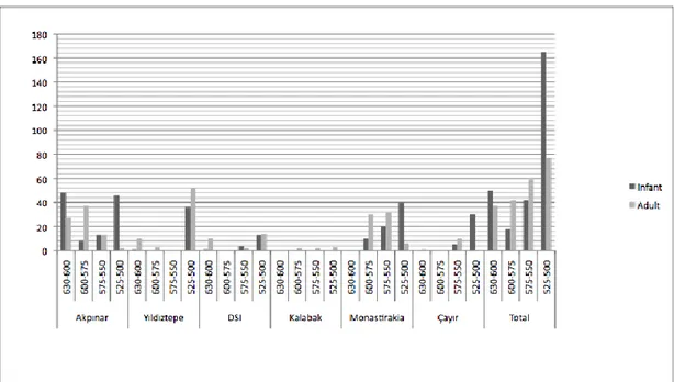
The methodological and theoretical approaches of this study are varied. Chapters 2 and 3, in which the material is introduced, are mostly descriptive. Discussion Chapter 4 was partly inspired from the study of Ian Morris, Burial and Ancient Society: The Rise of the Greek City-State (1987), but modified by critiques of many scholars and indeed of Morris himself (Morris 1998: 21-30). His processual and partly post-processual methodology and his demographic analyses inspired me to reach for more holistic interpretations for Clazomenae. The demographic and statistical analyses are important, since such analyses have never been made for Clazomenae. However, the dependability of the analyses is discussible in some respects. When the evidence is not sufficient, as in Kalabak, Monastirakia, DSĠ, and South cemeteries, the ratios and results can show incoherent divergences. Because of that reason, I have avoided analyzing some burial grounds individually and instead, I have incorporated their data into general charts, where their deviations will not distort the overall results.
Chapter 2 is divided into three chronological groups: Protogeometric (1050-900), Geometric (900-700), and Archaic2 (700-500/480)3. Only the PG and Geometric graves will be introduced in a detailed manner, because almost none of them are published yet. Archaic cemeteries will be introduced according to
2
The Orientalizing period (700-610 BC) has been accepted as a part of the Archaic period in this study, because it represents only a pottery style, not an individual period.
3
The chronology used in this study is based on Attic Greek chronology. Desborough’s chronology for the Protogeometric and Coldstream’s chronology for the Geometric periods are accepted. cf. Whitley 2006: 60-61, fig. 4.1.
chronological phasing for some burial grounds, total number of graves, grave types, grave good numbers and their quantity and quality, age distribution, gender, and uniformity of orientation.
In Chapter 3, other Ionian sites, which have yielded graves, will be introduced by periods: Protogeometric, Geometric, and Archaic Periods.
In Chapter 4, the descriptive information introduced in Chapters 2 and 3 will be discussed and interpreted. Aspects investigated will include burial practices and grave types, gender, age distribution, family clusters, grave goods, uniformity in orientation, rank, spatial relationships of cemetery and settlement in terms of intramural and extramural burials. Lastly, the emergence of Clazomenae as a city-state, as revealed by the development of the burial grounds, will be examined. Conclusions of the study are presented in Chapter 5.
CHAPTER 2
BURIALS AND CEMETERIES AT CLAZOMENAE
11
th– early 5
thc. BC
This chapter introduces Clazomenean burial grounds and burials dated to the PG, Geometric, and Archaic periods. Graves and cemeteries will be presented chronologically and according to burial grounds.
The site of Clazomenae, modern Ġskele, has been inhabited from the Late Neolithic to modern times. The prehistoric settlement is located on the so-called Limantepe mound. Evidence is abundant for the Early and Middle Bronze Age levels, less, so far, for the Late Bronze Age (Map 4).
2.1 A historical overview of pre-classical settlement of Clazomenae
The settlement was refounded during the second half of the tenth century, it has usually been thought. However, the pottery and architectural evidence discovered during the new excavations suggest a much earlier date, perhaps at the end of the eleventh century (Aytaçlar 2004: 29). Excavations from 1998 to 2004 on the south slope of Limantepe mound (KET) unearthed a Protogeometric apsidal structure with two phases. The first phase is dated between the end of the eleventh century and the first half of the tenth century (Aytaçlar 2004: 24). Although there is only one area on the KET sector with architectural remains belonging to a building from the PG
period, there are many dispersed finds dating to PG from the south and west of the mound, for example in sectors FGT, MGT, and especially HBT (Aytaçlar 2004: 25). Recent excavations in HBT have brought to light much significant information. A PG period kiln has been recovered4, as well as, numerous PG graves (Bakır et al. 2008: 323; Ersoy et al. 2008: 237-239). New evidence from the HBT sector indicates that the PG settlement expanded over an area extending nearly 700 m, southeast of the apsidal structure (Maps 5-6, Pl. 3a).
Geometric period Clazomenae is little known, in terms of either settlement pattern or burials (Ersoy 2004: 43). The Early and Middle Geometric styles are not represented at Clazomenae, while the PG tradition most probably persisted until the middle of the eighth century and vessels of this tradition were found together with some Late Geometric period finds (Aytaçlar 2004: 43; Ersoy 2004: 44). To separate the architectural and other finds of the PG period from those of the Geometric period is not as easy as at other Aegean sites. The other important point is that some part of the Geometric and Archaic settlement, which is to the west of the Limantepe mound, sunk into the sea after severe tectonic changes (Ersoy 2004: 53). So far, the Geometric period settlement was placed in MGT, FGT, and KET and partly HBT sectors that are to the south and southwest of the Limantepe mound. There are some traces of structures and floors of the middle and late eighth century in MGT and FGT sectors (Ersoy 2004: 45-47; 2007: 154-157).
Archaic period Clazomenae, ca. 700-480 BC, is well represented in terms of both settlement pattern and burial grounds. Especially, the cemeteries of the period are rich and significant information about the period comes from them.
The seventh century settlement in Clazomenae is attested in both the southern and the western areas. The Limantepe mound, in contrast, yielded only dispersed pottery pieces and some wells during the Archaic period. On the south, seventh century structures have appeared in the MGT and FGT areas. There are two or perhaps three structures built between around 670 and 600/580 BC, two of them apsidal (Ersoy 2004: 53). In sector MGT, there are also some architectural remains dated to the late seventh century. To the west of the city, in the HBT area, five rectangular buildings of the early sixth century have been revealed. The Acropolis sector and HBT were most probably used as industrial areas during the sixth century (Map 7).
There is a break between 550 and 530 BC in Clazomenae in terms of both settlement and burial patterns. During this phase, neither pottery fragments, nor architectural or grave remains are known. This period can be related with the first Persian attack against West Anatolia in 546 BC. The inhabitants must have abandoned the city. Around 530/525 BC Clazomenaeans returned and rebuilt the settlement. From this time to 499 BC was a golden age for Clazomenae. The last quarter of the sixth century is the best-represented period archaeologically. The pottery production and the trade with settlements in Ionia and elsewhere increased rapidly. The city walls and city gate were rebuilt on a monumental scale.
2.2 The Burials
2.2.1 Protogeometric Period
There are at least thirty-five graves attested to the PG period, with some others datable to either the LPG or the Geometric period. Twenty-five graves were
unearthed in HBT, seven in LMT-KET, one in Yıldıztepe, and one in the Third Degree Archaeological Site excavations from the west of the Archaic period city.
Graves dated to the PG period, especially these discovered from 2005 to 2009, have not been the subject of detailed study. Some of them are partly published in the KST in preliminary reports. Burials unearthed in the LMT-KET and HBT sectors will be introduced in the following pages.
2.2.1.1 HBT Sector
The HBT sector yielded forty-four graves in total (Map 5, 7; Pls. 5a-b,
6a-b), at least twenty-six of which are dated to the PG period (Tab. 3). All PG graves
were found in the excavation seasons from 2005 to 2009. The number of graves may increase, since some of the graves that have been dated to the Geometric period might be re-dated to the PG period. This is because the transition from PG to Geometric in Clazomenae is not sharp and easily recognizable.
PG graves in the HBT sector were discovered at the same time as the Archaic fortification was being excavated (Map 7, Pl. 8a). During the search for the traces of the Archaic city wall on the north and the south as well as the monumental city gate, many trenches and test sondages were opened, eventually leading to the discovery of many graves. The graves are mainly concentrated at the east of the fourth century BC “ruler’s house” and under the Archaic fortification walls.
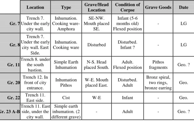
1) Grave 5
Location: Within the borders of the Archaic period city wall (Pl. 7a). Rite: Inhumation. Grave Form: Pithos.
Dimensions: N.A. (= information not available)
Grave Goods: dispersed pottery fragments. Date: LPG (Bakır et al. 2007: 190).
Additional Information: The pithos is lying on its side. 2) Grave 6
Location: Within the borders of the Archaic period city wall, just east of Grave 5. Rite: Inhumation. Grave Form: Pithos Dimensions: N.A.
Orientation: E-W (head to the W) Skeletal Information: Adult, in flexed position Grave Goods: scattered pottery fragments.
Date: LPG (Bakır et al. 2007: 190).
Additional Information: The pithos is lying on its side. (pl. 7b).
3-7) Graves 17, 18, 19, 25, and 26 were found in the same area, which is located around 10 m southeast of the Archaic city gate. Graves 18-19 were found in Trench 15 (Pl. 8b), approximately 20 cm under Grave 17.
3) Grave 17
Location: South of Trench 15 (Pl. 8a).
Rite: Inhumation. Grave Form: Neck-handled Amphora. Dimensions: N.A. Orientation: E-W (mouth to the W) Skeletal Information: Infant.
Grave Goods: None.
Date: LPG due to the amphora itself. It is decorated with semi-circles on the
shoulder. Similar examples were found in Athens, Kerameikos (PG 43), and Marmariani (Lemos, I. 2002: 58-59, 152-153). The amphora was probably imported from Athens.
Additional Information: The body was inserted from the side of the vessel as is
shown by the break in its walls.
4) Grave 18
Location: South of the Trench 15, approximately 20 cm under Grave 17 (Pl. 9a). Rite: Inhumation. Grave Form: Hydria. Dimensions: N.A.
Grave Goods: None.
Date: MPG or LPG due to being found under Grave 17.
Additional Information: The rim of the pot is missing; the pot burial is closed with
a rough circular stone.
5) Grave 19
Location: South of the Trench 15, approximately 1 m north of Grave 18 (Pl. 9b) Rite: Inhumation. Grave Form: Handmade Pot . Dimensions: N.A. Orientation: NW-SE (mouth to the SE) Skeletal Information: Infant. Grave Goods: None.
Date: MPG or LPG.
Additional Information: Mouth of the pot is closed with a big slab and stones
support its east side. 6) Grave 21
Location: In front of the Archaic period city gate (Pl. 10a).
Rite: Inhumation. Grave Form: Pithos. Dimensions: N.A.
Orientation: N-S (mouth to the S) Skeletal Information: Adult, bone fragments. Grave Goods: one: skyphos.
Date: LPG.
Additional Information: It is dug into bedrock and lying on its side, but the mouth
of the pithos is slightly raised.
7) Grave 24
Location: In Trench 11, west of the seventh century BC city wall (Pl. 10b)
Rite: Cremation. Grave Form: Cremation Area Dimensions: 150 x 60 x 42 cm Orientation: W-E Skeletal Information: Adult, Burnt human, maxilla, and
animal bones Grave Goods: one: bronze fibula like-object (Pl. 11b).
Date: LPG. Objects similar to the “arched fibula” are known from Elateia
(Dickinson 2006: 158-171, fig. 5.22.10); Athens, Kerameikos and Agora (Lemos, I. 2002: 109-110, fig. 2.1-2-3-5); and Lefkandi, Toumba (Lemos, I. 2002: 109-110, fig. 3.1-2).
Additional Information: It is cut into bedrock with one step. The traces of the
mud-brick can be observed on its north side. It was full of very soft, dark gray and brown burnt earth. However, there are definitely human, notably a maxilla and animal bones.
8-10) Grave 26, a triple interment enclosed by a stone wall, was found at Trench
16, northeast of the PG period kiln, which dates the complex (Pl. 11b). The burials consist of an amphora (Grv. 26.1), a coarse ware pot (Grv. 26.3) and a simple earth inhumation (Grave 26.2) (Pls. 12a-b). The explanation comes to mind that the complex was a small family cluster. On the other hand, it is hard to determine whether the cluster was being used for generations or they were buried suddenly as a member of one family due to an unfortunate plague.
8) Grave 26.1
Location: North of the PG period kiln (Pl. 11b, 12b).
Rite: Inhumation. Grave Form: Amphora. Dimensions: N.A. Orientation: E-W (mouth to the W) Skeletal Information: Infant. Grave Goods: None.
Date: PG.
9) Grave 26.2
Location: North of the PG period kiln (Pl. 12a).
Rite: Inhumation. Grave Form: Simple Inhumation. Dimensions: N.A. Orientation: - Skeletal Information: Adult.
Grave Goods: None. Date: PG.
10) Grave 26.3
Location: North of the PG period kiln (Pl. 12b).
Orientation: N.A. Skeletal Information: Infant. Grave Goods: None.
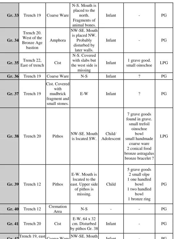
Date: PG. 11) Grave 28
Location: Trench 17, SE of the Archaic bastion.
Rite: Inhumation. Grave Form: Cist. Dimensions: N.A.
Orientation: EW Skeletal Information: Child, scattered bones Grave Goods: None.
Date: PG. 12) Grave 31
Location: East of the PG period kiln near graves 26-29 and 32 (Pl. 14a). Rite: Inhumation. Grave Form: Pithos. Dimensions: -
Orientation: EW (head to the E) Skeletal Information: Infant.
Grave Goods: Four: 2 small one-handled bowls; small oinochoe with firnis band
system; small amphora with two vertical handles and long neck (Pl. 14b).
Date: LPG. 13) Grave 35
Location: Around 60 m north of the PG period kiln (Pl. 16a).
Rite: Inhumation. Grave Form: Cist. Dimensions: 78 x 43 x ? cm Orientation: NS Skeletal Information: Infant.
Grave Goods: One: one-handled olpe with two rows of wavy line decoration on the
shoulder.
Date: PG. 14) Grave 38
Location: West of the BA fortification wall and bastion (Pl. 17a). Rite: Inhumation. Grave Form: Pithos. Dimensions: N.A.
Grave Goods: Seven: bronze astragalus, small trefoil oinochoe, small handmade
vessel, one-handled close vessel, one-handled bowl, two conical formed foot fragments.
Date: LPG. 15) Grave 39
Location: Between 4th c. BC terrace wall and the Archaic city gate, above Gr. 40.
Rite: Inhumation. Grave Form: Pithos Dimensions: N.A. Orientation: E-W (mouth to the E) Skeletal Information: Child.
Grave Goods: Five: 2 bowls; small olpe with three rows of semi-circles on
shoulder; small closed vessel with a firnis band system; bronze ring (Pl. 17a).
Date: LPG. 16) Grave 40
Location: Between 4th c. BC terrace wall and the Archaic city gate, below Gr. 39.
Rite: Cremation. Grave Form: Cremation Area. Dimensions: 172 x 90 cm Orientation: N-S Skeletal Information: Adult.
Grave Goods: None. Date: LPG.
Additional Information: It is cut into bedrock. The north side of Grave 40 was
totally gone during the burying process of Grave 39. It revealed burnt earth and a small number of burnt bones. A comparison of this cremation area with the one of Grave 24 shows that it was used much less intensively, maybe once or twice, until disturbance by a later pithos grave.
17-27) Graves 25, 29, 30, 32, 33, 34, 36, 37, 41, 42, and 43, all without grave goods,
will not introduced in detail. For information see Tab. 3.
Discussion
The area produced one possible Bronze Age grave and twenty-seven PG period graves (Maps 5-7, Pl. 3a). All graves with the exception of the cremation areas (Grave 24 and 40) are inhumation. Three types of inhumation were practiced in
the sector HBT: inhumation in pots (seventeen graves); cist graves (five graves); inhumation in the earth (three graves). Pithos graves are represented with six graves, coarse ware pots with seven, amphora with three, and hydria with one grave. There is no certain uniformity in orientation for graves. Nine are oriented east-west, six are north-south (hydria, pithos), five are northwest-southeast, and three northeast-southwest. The extramural burial ground was used both for adults and children. Adults were buried in pithoi, in simple earth inhumations, and in the cremation areas. Infants and children were buried in amphoras, hydrias, cooking ware pots, and cist graves. In total, there are eight adults, sixteen infants and three-child/adolescent graves.
The tradition of offering grave goods was not so popular during the PG. Only six graves contain grave goods. The grave good types are pottery and bronze objects. The pottery types are skyphos, olpe, oinochoe, bowl, small amphora, and jug. Grave goods made of bronze are fibula and bracelet.
2.2.1.2 Limantepe and KET Sectors
The LMT-KET-FGT sectors were probably the center of the settlement from the Bronze Age until the end of the Classical period (Pl. 3a) (Bakır et al. 2004: 102; 2006: 464; Ersoy 2007: 149). The Limantepe mound and the south slope of the mound, KET, and FGT sectors, produced seven graves dated to the PG period (Map
8, Tab. 5). It is necessary to say that only a very small part of the KET sector has
been excavated so far. It is highly possible that many undiscovered graves remain in this sector. Four of the graves were found in the Limantepe excavations and the only information about these graves comes from KST.
1) Grave 1
Location: South slope of the Limantepe mound, south of the MBA bastion. Rite: Inhumation Grave Form: Cist Dimensions: length: 46 cm Orientation: SE-NW Skeletal Information: Infant, in flexed position Grave Goods:None.
Date: PG (Erkanal and Günel 1995: 273). 2) Graves 2-3-4
Location: South slope of the Limantepe mound (Erkanal 1999: 327)5.
Rite: Inhumation. Grave Form: Cist. Dimensions: N.A.
Orientation: - Skeletal Information: -
Grave Goods: None. Date: Probably PG and maybe Geometric Period. 3) Grave 5
Location: Limantepe mound, in square VII, dug into the MBA debris (Pl. 3b). Rite: Inhumation. Grave Form: Pithos. Dimensions: N.A.
Orientation: E-W (head to the E) Skeletal Information: Infant, 0-6 months old Grave Goods: Four: an oinochoe decorated with semi-circles on the shoulder; a jug;
a one handled-cup in gray monochrome style; and a one handled cup (Pl. 4a).
Date: LPG. The oinochoe shows close affinities with Kos and Lefkandi materials.
(Aytaçlar 2004: 27; Bakır et al. 2001: 32; Hürmüzlü 2005: 44).
4) Grave 6
Location: KET sector, under the PG curvilinear structure (Pl. 4b). Rite: Inhumation. Grave Form: Cist. Dimensions: 95 x 46 cm Orientation: NW-SE Skeletal Information: Infant, around 9 months old.
Grave Goods: One; a skyphos with a high conical foot and an irregular wavy line
ornament.
Date: LPG (Aytaçlar 2004: 27).
5 It is not clear from the publication whether the architectural remains belong to the sixth or seventh century. There is a possibility that remains belong to the earlier period.
Additional Information: The mouth of the grave was closed with a stone slab. The
grave was covered with vertical stones. It is disturbed.
5) Grave 7
Location: FGT Sector, NW of the FGT sector.
Rite: Inhumation. Grave Form: Cist. Dimensions: N.A. Orientation: - Skeletal Information: Infant.
Grave Goods:None.
Date: Probably PG.
6) Some other scattered finds can be interpreted as graves from
LMT-KET sectors. A find of an almost complete hydria is an interesting case. This hydria, which is dated to the PG period, was found during the cleaning of the section in KET and was interpreted by Aytaçlar as a possible urn grave (Bakır et al. 2004: 32). However, the insecure find spot of the vase and the lack of evidence of other graves from Clazomenae make this interpretation unlikely.
Discussion
The PG period is represented by seven graves in the LMT-KET sector. Six are inhumation graves in a cist and the last one is an inhumation grave in a pit. Both cist Graves 1 and 6 are oriented southeast-northwest. All cist graves are most probably infant graves. The burial type of inhumation in a pot is represented in only one example in Grave 5, which is the richest PG grave in the area.
Only two graves contain grave goods. Grave goods in Grave 5 and 6 are an oinochoe, a jug, one-handled cups, and a skyphos.
2.2.1.3. Yıldıztepe Cemetery
There is no securely dated PG grave in Yıldıztepe. During the excavations, however, fragments of a neck-handled amphora and associated burnt bones and soil were collected on the surface of the south slope of Yıldıztepe. The style of the sherds dates to them to the second half of the tenth century. (Aytaçlar 2004: 26; Hürmüzlü 2005: 44). Aytaçlar and Hürmüzlü interpreted the amphora as an urn grave.
2.2.1.4 Third Degree Archaeological Site Excavations
Iskele, Urla, because of the ancient remains, has been officially classified as an archaeological site. However, as a developing place, there have been many constructions during the past 10 years, especially for summer residences. During construction projects the Ġzmir Archaeological Museum excavates each building site; during these salvage excavations many archaeological remains have been found. One of these excavations revealed a PG period grave around 300 m northwest of the extramural burial ground in the HBT sector. The grave is an inhumation in a pot with one grave good.
Discussion: Burials of the Protogeometric Period
The thirty-six PG period graves were introduced in detail in the previous pages. Thirty-three are inhumation graves and the other three are cremation graves. The inhumation grave types are pithos, coarse ware pot, amphora, hydria, cist and simple inhumation. The cremation types are cremation areas that were cut into the rock in rectangular form and urn burial. There is no uniformity in orientation for graves, but the preferred orientation is east-west. Infant, child, adolescent, and adult graves are represented in the PG period. The LMT-KET sector has revealed only
infant and child graves. The HBT sector has been used for both infants and adults. Twenty-five graves belong to infants; three belong to children/adolescents, and eight belong to adults. Nine of thirty-six graves contain grave goods. The number of grave goods varies from one to seven. It is possible to say that the number of the PG graves will be increased in the coming years.
2.2.2. Geometric Period
The Geometric period is not well represented in Clazomenae either in settlement or burial patterns (Ersoy 2004: 44-49; 2007: 153-157; Hürmüzlü 2005: 44) (Maps 5-7). There are no graves from the ninth century and only eight graves dated to the eighth century BC. The Geometric period burials were found in the KET and HBT sectors.
Graves dated to the Geometric period have not been studied before. Some graves are partly published at the KST in preliminary reports. Burials unearthed in the LMT-KET and HBT sectors will be introduced in the following pages.
2.2.2.1. HBT Sector
Six graves found in the HBT sector have been dated to the Geometric period. The usage of this extramural burial ground probably continued until the end of the Geometric period or the construction of the city wall.
1) Grave 7
Location: Under the fillings of the fortification wall at Trench 7 (Pl. 18b). Rite: Inhumation. Grave Form: Coarse Ware Pot. Dimensions: N.A. Orientation: SE-NW (mouth to the SE) Skeletal Information: Infant. Grave Goods: None.
Date: End of the eighth century BC due to the coarse ware. These types of pots were
also found in Athens, in the Athenian Agora, and dated to the end of the eighth century (Brann 1962: 54, pl. 11-195,196).
2) Grave 8
Location: At Trench 7, 3 m east of Grave 7.
Rite: Inhumation. Grave Form: Coarse Ware Pot. Dimensions: N.A. Orientation: - Skeletal Information: Infant/Child.
Grave Goods: None. Date: LG.
Additional Information: Grave 8 was disturbed to a great extent when the city wall
was being constructed; only a few pieces of the pot and small pieces of bones are preserved.
3) Grave 11
Location: Under the south bastion at Trench 8 (Pl. 19a).
Rite: Inhumation. Grave Form: Simple Inhumation. Dimensions: Length: 146 cm Orientation: NS (mouth to the S) Skeletal Information: Adult, in flexed position. Grave Goods: None.
Date: Geometric.
Additional Information: The grave is covered with stones.
4) Grave 20
Location: In front of the Archaic period city gate, just north of Grave 21 (Pl. 10a). Rite: Inhumation. Grave Form: Pithos. Dimensions: N.A.
Orientation: EW (mouth to the W) Skeletal Information: Adult, in flexed position. Grave Goods: Four: a bronze spiral, 2 bronze rings, bronze earring.
Date: Geometric.
Additional Information: The pithos is placed in a shallow pit cut into the bedrock.
The pithos is lying on its side. The upper side of the grave is missing; probably because during the construction of the monumental entrance of the late sixth century fortification wall, the upper side of the grave was cut. It belongs to an adult, due to dispersed skull, chin, foot, toe, and other bones.
5) Grave 22
Location: In Trench 11, at the east of the early Archaic period city wall (Pl. 19b). Rite: Inhumation. Grave Form: Cist. Dimensions: N.A.
Orientation: EW Skeletal Information: Infant. Skull preserved. Grave Goods: None.
Date: Geometric. The grave rests on the rectangular platform, which can be dated
some time in the Geometric period. The grave should be dated to the period earlier than 670 BC due to being under the early Archaic city wall and later than LPG period due to being above the cremation area.
Additional Information: Grave 20 is placed on the bedrock. The grave consists of
four vertical slabs and no cover (Ersoy et al. 2008: 240).
6) Grave 23 A
Location: In Trench 11, just under the Archaic city wall (Pl. 19b)
Rite: Inhumation. Grave Form: Simple Inhumation. Dimensions: N.A. Orientation: EW (head to the W?) Skeletal Information: Adult. Dispersed bones. Grave Goods: None.
Date: Geometric. It should be dated to earlier than 670 BC, and most probably to the
LG period.
Additional Information: The grave was disturbed both during the construction of
the Archaic city wall and by the filling of the fourth century. Not completely excavated.
7) Grave 23 B
Location: In Trench 11, south of Grave 23A. (Pl. 19b)
Rite: Inhumation. Grave Form: Simple Inhumation. Dimensions: N.A. Orientation: NW-SE (head to the SE?)
Skeletal Information: Adult. Dispersed bones. Grave Goods: None.
Date: Geometric.
Discussion:
The Geometric period is represented with seven graves in the HBT sector. The types of burials are inhumation in pithos and cooking wares, cist grave, and simple earth inhumation. There are three simple inhumation graves and two of them have not yet been excavated completely. The burial customs from PG to Geometric period seem similar in HBT. There is no evidence of the practice of cremation in HBT. The grave goods are rare. There is no uniformity in orientation. Adults, infants and children are buried in the same ground as in the PG period. It seems that the area was used as a burial ground until around 700 and after that in 675-650 the fortification wall of the city was built in the same area. (Ersoy 2007: 175; Güngör 2006: 54, 142; Hürmüzlü 2005: 45-47)
2.2.2.1. KET Sector 1) Grave 7
Location: Under the early sixth century BC stone floor in the KET sector (Pl. 18a). Rite: Inhumation. Grave Form: Coarse Ware Pot. Dimensions: N.A.
Orientation: E-W (mouth to the W) Skeletal Information: Infant. Grave Goods: None.
Date: Earlier than early sixth century BC, probably LG period.
Additional Information: The upper side of the pot is removed, maybe to receive the
body into the pot. It is supported by three stones.
2) Grave 8
Location: Under the early sixth century BC stone floor in the KET sector (Pl. 18a). Rite: Inhumation. Grave Form: Coarse ware pot. Dimensions: N.A.
Orientation: N-S (mouth to the S) Skeletal Information: Infant. Grave Goods: None.
Additional Information: The upper side of the pot is removed, maybe to receive the
body into the pot. Some pithos body fragments are used to cover the mouth of the grave (Bakır et al. 2005: 2-3; Hürmüzlü 2005: 44).
Discussion
Graves found in the KET sector show that the intramural burial tradition was practiced at least to the late eighth century there6. Only infants were buried in Geometric period KET sector as in PG (Map 8). When we compare burial customs from PG to the Geometric period in KET sector, there are almost no differences in the practice of burials, grave goods are rare, used only for infants and children, and there is no practice of cremation. It seems that Clazomeneans practiced very similar burial customs both in the LMT-KET and HBT.
2.2.3. Archaic Period
Archaic Clazomenae is very rich in terms of the existence of graves and cemeteries compared with other cities in Ionia, West Anatolia, and even Mainland Greece. The existence of the rich burial records in the Archaic period helps us to understand the burial customs, the relationship between settlement and cemeteries, the selection of the settlement and necropolis areas, the development of the pottery and Clazomenean sarcophagus styles, comparison of the burial customs, the grave goods, pottery and sarcophagus types, and the chronology of different cemeteries.
Seven different cemeteries with varying numbers of graves have been recovered to date (Map. 9; Pl. 1, 2, 20). In addition to the cemeteries, thirteen Archaic period tumuli have been found (Hürmüzlü 2003: 3-4; 2004a: 78; 2005: 47;
6The graves found in the KET sector were dated to the end of the eighth century by the excavator, but she indicates that the graves were not securely dated due to lack of grave goods and they could be dated to later than the eighth century. The tradition of burying infants as an intramural burial probably goes as late as 630 BC, so graves found in the KET sector can be dated as late as 630 BC.
Ersoy 2007: 175). The cemeteries identified so far are Monastirakia, Yıldıztepe, Çayır, DSĠ, Kalabak, Akpınar, and South. The South necropolis, the most recently discovered, was found during the Third Degree Archaeological Site excavations by the Ġzmir Museum in December 2008.
Cemeteries surround the city on the northwest, southwest, and east. The Akpınar cemetery is located to the west of the Archaic settlement. Monastirakia and Yıldıztepe cemeteries are located close to each other southwest of the settlement. The burial grounds to the east of the settlement are, from west to east, Çayır, DSĠ, and Kalabak (Hürmüzlü 2003: 2-4; 2004a: 77-79; 2005: 45-47; Güngör 2006: 1, 54-56; Ersoy 2007: 174-177). The South cemetery is located around 2 km south of the Archaic city on the way leading to Urla. Recent excavations have shown that these last burial sectors, Çayır, DSĠ, Kalabak, and South, are part of one big necropolis
Cemeteries and tumuli will be introduced in following pages. In some cases, because of the lack of systematic excavations, the information available is deficient
2.2.3.1 Akpınar Necropolis
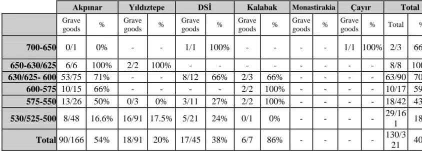
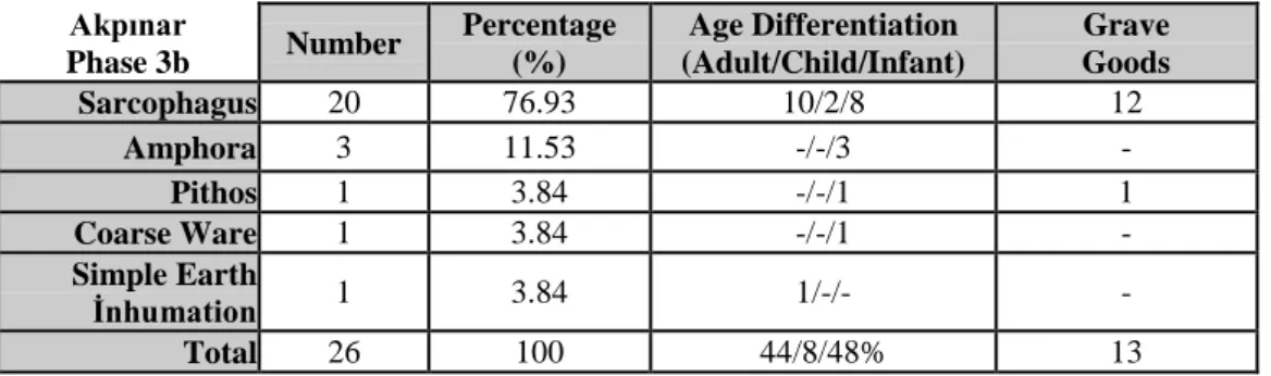
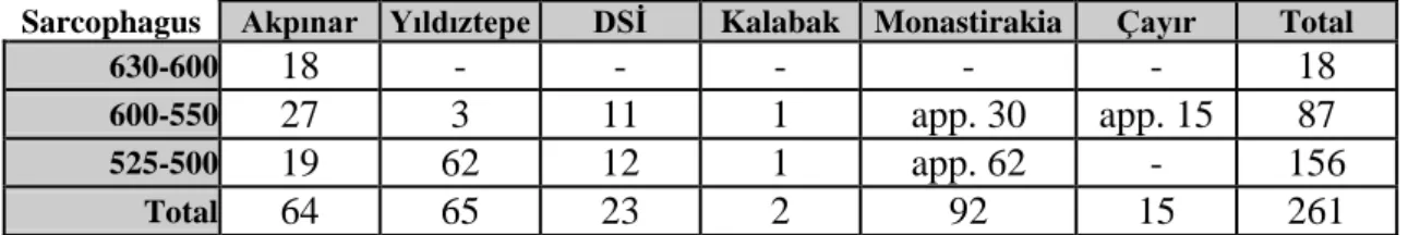
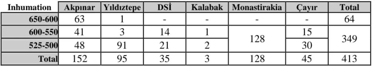
The Akpınar necropolis was discovered in 1995 and excavated until 2002. It is one of the richest and most important cemeteries in Clazomenae, because luckily it was excavated systematically and produced very beneficial results with respect to tracking the changes of the burial types and burial customs from the early seventh century BC to the Hellenistic period, but most intensely between 650-500 BC. In addition, this cemetery has given very good information about the development and chronology of Clazomenean ceramics, sarcophagus types, and pottery styles. 262 graves were unearthed during excavations; 169 of these certainly belong to the Archaic period.
The Akpınar cemetery is located at the northwest of the Archaic settlement, southeast of Nalbanttepe. The cemetery lies parallel with the coastline (Hürmüzlü 2003: 8; 2004b: 195; 2004a: 79). The necropolis extends over an area of 5000 m2. The south border of the necropolis is probably an ancient river, the west side is restricted by natural rocks, the east border most probably is under the sea today, and the north border is not known exactly (Hürmüzlü 2003: 10) (Pl. 23a).
The Archaic period of the necropolis is divided into four phases by Hürmüzlü (Hürmüzlü 2004a: 84-88; 2004b: 195-196), which are:
Phase 1 (ca. 700-630 BC) Phase 2 (ca. 630-600/590 BC) Phase 3 (ca. 600/590-550 BC) Phase 4 (ca. 530-500/490 BC)
The divisions are actually arbitrary and aim to clarify the changes of the burial customs through time. Moreover, Phase 3 and 4 can easily fit in with the historical situations; for example, the Persian invasion of 546 BC can be followed from the Akpınar necropolis. The division of Hürmüzlü is practical and there is no need to make a new chronology. The only difference is I subdivided Phase 3 into Phase 3a and Phase 3b (see p. 32). I will present the burials, burial types, and burial customs of the Akpınar necropolis following Hürmüzlü’s division.
2.2.3.1.1. Phase 1 (ca. 700-630)
The first phase of the Akpınar necropolis lasted around seventy years and included only seven graves. The area, which was selected for a necropolis, had been leveled before being intensively used. Only one grave, a simple inhumation, was dug
before the leveling process. The other six graves all cremations, were dug after the leveling (Hürmüzlü 2003: 11-12).
The earliest burial in the Akpınar necropolis is a simple earth inhumation (Grave 171). The skeleton is in the flexed position. The corpse is placed as if looking down. The grave contains no grave goods and belongs to a 55-65 year-old woman (Hürmüzlü 2003: 207). The grave is dated to before 650 BC, because the person was buried before the leveling process of the area.
All the cremations took place in situ. Cremations both in Phase 1 and Phase 2 were practiced in a similar way. The cremation process took place in an oval or circular shaped depression approximately 3 x 4 m in dimension, 20-30 cm in depth. The floor of the cremation holes was hardened and the earth would become red in color (Hürmüzlü 2003: 241). After the burning process the bones were not collected. The condition of the bones shows that the burning process continued until the bones became very small fragments. The grave goods were placed in the cremation area, before the cremation process started, because many offerings were found partly burnt. In contrast, drinking vessels were only partly burnt, which shows that drinking vessels were most probably thrown into the grave at the end of the ceremony. After the cremation ceremony, the fire was covered with sand and pebbles. After the covering process, a ceremony was carried out on the grave, because many cooking wares, unburned, were found on top of the cremation burial (Hürmüzlü 2003: 242-245; 2004a: 80-81; 2004b: 195).
Cremation graves are spread throughout the necropolis and were found at the funerary enclosures A, B, C, E and N. Actually, the cremation graves in Phase 1 had been used when the enclosure system was being practiced; however, there is a