71:4 (2014) 71–78| www.jurnalteknologi.utm.my | eISSN 2180–3722 |
Full paper
Jurnal
Teknologi
Application of Low-Cost GPS Tools and Techniques for Landslide
Monitoring: A Review
E. E. Eyo,a,*, T. A. Musa,a K. M. Omar,a K. M.Idris,a T. Bayrak,b I. C. Onuigbo,c Y. D. Opaluwa,a
a
Department of Geomatic Engineering, Faculty of Geoinformation & Real Estate, Universiti Teknologi Malaysia, 81310 UTM Johor Bahru, Johor, Malaysia
b
Faculty of Engineering and Architecture, Department of Geomatics Engineering, Sinop University, Turkey, Korucuk Köyü Trafo Mahallesi No: 36 57000
c
Department of Surveying & Geoinformatics, School of Environmental Technology, Federal University of Technology, Minna, Nigeria *
Corresponding author: [email protected]
Article history
Received :6 February 2014 Received in revised form : 24 July 2014
Accepted :9 October 2014
Abstract
The main goal of our ongoing research is to design a low-cost continuous monitoring system for landslide investigation using the Reverse RTK (RRTK) technique. The main objectives of this paper are to review the existing Global Positioning System (GPS) tools and techniques used for landslide monitoring, and to propose a novel low-cost landslide monitoring technique using Reverse RTK GPS. A general overview of GPS application in landslide monitoring is presented, followed by a review of GPS deformation monitoring systems and some of the factors used for their categorization. Finally, the concept, principles and advantages of the proposed new landslide monitoring system are discussed.
Keywords: Continuous landslide monitoring, Low-cost, Reverse RTK, GPS
Abstrak
Matlamat utama kajian ini adalah untuk mereka bentuk system pemantauan berterusan yang melibatkan kos yang rendah bagi tujuan penyiasatan tanah runtuh menggunakan teknik reverse RTK (RRTK). Objektif utama kertas ini adalah mengkaji semula alat sistem penentududukan sejagat (GPS) sedia ada dan teknik yang digunakan untuk memantau tanah runtuh, untuk tujuan teknik novel pemantauan tanah menggunakan RRTK GPS yang kos rendah. Satu gambaran umum aplikasi GPS dalam pemantauan tanah runtuh akan dibentangkan, diikuti dengan kajian semula beberapa faktor dalam system pemantauan GPS yang digunakan. Akhirnya, konsep, prinsip dan kelebihan sistem pemantauan tanah runtuh yang dicadangkan akan dibincangkan.
Kata kunci: Pemantauan tanah runtuh secara berterusan, kos rendah, reverse RTK, GPS
© 2014 Penerbit UTM Press. All rights reserved.
1.0 INTRODUCTION
Landslide is defined as ‘‘the movement of a mass of rock, debris, or earth down a slope’’.1
Different factors are responsible for the occurrence of landslides. These include intense or prolonged precipitation, earthquakes, volcanic eruptions, rapid snow melting, and various anthropogenic activities. Landslides are natural hazards which are difficult to predict in time and in space. This is because their initiation depends on many complex factors, and the relationship and interaction between these factors are uncertain. The landslide phenomena consist of a large spectrum, which are diverse and complex in nature. This spectrum include the following: landslide length, landslide area/volume, landslide velocity, total number of landslides, triggering time, and landslide lifetime.2 These diverse and complex nature of landslide phenomena makes it practically difficult to adopt a particular technique and instrumentation to map and monitor landslides.
The two basic peculiarities of the landslide phenomenon are: 1) landslide-prone slopes are present in virtually every part of the
globe, and 2) the landslide process is highly influenced by human- and natural-induced changes in the slopes and controlling factors.3 Besides these two peculiarities, the behaviour of landslide movement is time-dependent.4-5 Globally, there is an upsurge in landslide occurrence, which could be attributed to the increasing human activities on the environment6-7 and the impact of climate change.8 The consequences of landslides are enormous. Recent landslide disasters in Brazil, Philippines, China, Taiwan, and Uganda, etc. have destroyed infrastructure, killed thousands of people, and resulted in heavy economic losses.9 The continuous occurrence of disastrous landslide events has increased the demand for new and improved techniques for landslide monitoring.
The Global Navigation Satellite Systems (GNSS) - GPS, GLONASS, Galileo, Compass, QZSS and IRNSS are now being utilised as global infrastructure for a wide range of applications. The Global Positioning System (GPS), in particular, has been widely used in monitoring the dynamics of landslide; and the focus of this review is mainly on the application of Real-Time Kinematic GPS.
Some of the advantages of RTK GPS which can be utilized for landslide monitoring application include: 1) post-processing is not required; 2) acquired coordinates of points can be easily transformed to local coordinate system in real-time; and 3) it is a reliable tool for monitoring multiple number of points - increasing productivity and saving cost.10 For a standard RTK GPS operation, dual-frequency geodetic-grade receivers with the supporting firmware/software are usually required. However, the high cost of these receivers and the supporting software is one of the reasons limiting the use of RTK GPS for several monitoring applications.11 Due to the harsh operational environment frequently faced during landslide monitoring, coupled with security concern and the prospect of losing the equipment during landslide event, the need for low-cost monitoring tools and techniques are imperative.
The big challenge in landslide monitoring is how to reduce the cost of the monitoring scheme. The cost of monitoring includes the costs of RTK GPS receivers, power supply, communication, logistics, personnel, etc. Several authors have proposed the use of low-cost GPS L1-only monitoring receivers.12-16 The short-coming of this approach is the fact that, unlike the dual-frequency data, the single-frequency GNSS receivers’ data cannot be corrected for ionospheric delay.17
The
single-frequency receivers also have inherent problem in the ambiguity resolution. Many low-cost landslide monitoring systems have been developed over the years.18-20 However, these monitoring systems still rely on receivers with expensive supporting firmware and which require complex computations at the user end. There exist no monitoring technique which completely eliminates all the complex algorithms and computations at the user end.
The main objectives of this paper are to review the existing GPS tools and techniques for landslide monitoring, and to propose a novel low-cost landslide monitoring system using the Reverse RTK (RRTK) technique.
2.0 OVERVIEW OF GPS APPLICATION IN
LANDSLIDE MONITORING
Landslide deformation monitoring is usually carried to obtain information on the physical and geometric parameters of the monitored terrain. The physical parameters include: slope geometry, complex soil materials, hydrogeology, weather, and geological structure, among others. The deformation monitoring of the physical parameters is conventionally done by computing the so called factor of safety, as a slope stability value. Information on the physical parameters can give a realistic picture of the landslide phenomenon, but it involves complex field conditions and soil material properties, which requires sophisticated and expensive tools to handle.21
The geometric parameters, on the other hand, consist of the position vectors, which can be used to predict the magnitude, direction, velocity and acceleration of the movement of landslide materials. Compared to the physical parameter measurements, the geometric parameter measurements are cheaper and involve a larger coverage area. However, the geometric parameter measurements cannot provide information on the complex soil material properties of the slope, which is a vital requirement in understanding the mechanism and characteristic of a landslide.21
The geometric parameter measurements basically involve the measurement of the surface displacements, usually determined using surface monuments. Surface displacements are indispensable indices for the determination of structural or slope stability.22 Usually, the unstable area being monitored can be impacted by repeated cycles of uplifting and subsiding
movements.23 This scenario demands instrumentation that can capture 3-dimensional slope motions in the horizontal and vertical planes.
The GPS has been rapidly and widely employed as a surveying and mapping tool for a number of monitoring applications.24,22 The last two decades has recorded a rapid growth in the number of researches investigating the use of GPS in monitoring the dynamics of landslide, and other related geohazards (e.g. earthquakes, volcanoes, glaciers, and tsunamis, etc.).
The five main reasons identified for the increasing application of GPS in monitoring the health of engineering structures, which also apply to man-made and natural slopes are: 1) the ease and speed of measuring the relative displacement of structures using GPS; 2) the availability of low-cost GPS hardware and software; 3) the flexibility and portability of deploying GPS in the field; 4) the global standard in GPS observation and processing, which enhances international collaboration; and 5) the increasing prospect of accuracy obtainable with GPS.25 In fact, the recent advances in sensor technology, and the possibility of acquiring 3D information of the terrain with high accuracy and high spatial resolution is opening new vistas in the deployment of GPS for landslide and geohazard monitoring applications.
GPS has been employed in landslide monitoring based on the type of monitoring campaigns, namely, periodic,26-28 and continuous.29-30 These studies highlight the critical factors in the choice of a particular monitoring campaign, which include: accuracy, cost, and safety of equipment, etc. Some studies in landslide monitoring have used GPS to compare results from conventional geomatic/geotechnical methods, such as theodolite, Electronic Distance Measurement, levels, total station, inclinometers, and wire extensometers.31-38
Other studies have integrated GPS and other geomatic techniques, namely, terrestrial laser scanning, Interferometric synthetic aperture radar (InSAR), digital photogrammetry, to investigate the landslide phenomenon.39-42 This combination provides valuable information on the magnitude and direction of the displacements, total volume of the moving mass, and the evolution of the landslide process.
Some studies have investigated the accuracy of low-cost single-frequency GPS receivers for landslide monitoring.43-44 Finally, GPS has been employed in landslide monitoring based on different GPS techniques, namely, static,45 rapid-static,46 real-time kinematic,47 and based on the comparisons of these techniques.48-49
3.0 A REVIEW OF GPS DEFORMATION
MONITORING SYSTEMS
The following review of existing GPS landslide deformation monitoring systems is not exhaustive. Although the focus of this review is on landslide-specific monitoring systems, the monitoring systems reviewed can be employed for both structural and slope deformation studies. There are many GPS deformation monitoring systems put in place by various commercial vendors, universities and research groups all over the world. Some of these monitoring systems include.
3D TRACKER: A product of partnership between Trimble and Condor Earth Technologies, Inc. (www.condorearth.com). It is a real-time GPS-based system for structural health monitoring, as well as deformation monitoring of landslides and other natural hazards. Using triple-differenced processing technique, 3D Tracker provides continuous monitoring, and automated alarm notification when established thresholds are
exceeded.50 3D Tracker uses a post-processing mode; it is not running in true real-time.
CODMS: Continuously Operating GPS Deformation Monitoring System (CODMS) was developed at Technical University Graz, Austria. It is a near real-time monitoring system based on double-differenced observations, and uses the GPS software GRAZIA.51 One of the main features of CODMS is its focus on the reduction of systematic errors, particularly the multipath. CODMS has been successfully employed for landslide monitoring in different areas in Austria, including Styria, Gradenbach and Brunnalm.52 In the first practical application of CODMS in Styria, the time-stacking technique was adopted to mitigate the effect of multipath.53 In the time-stacking technique, the time varying effects of multipath from two consecutive sidereal days were analyzed to mitigate the effect of multipath. The problem with this technique is that the deformation parameters (movement, velocity and acceleration) between these two sidereal days are mixed up, and only the velocity parameters can be obtained.52 The future research direction in CODMS has been towards the replacement of expensive GPS stations with low-cost GPS equipment.54 GeoMoS: Leica GeoMoS is a deformation monitoring system that is based on GPS double-differenced observations. It can be deployed for structural, landslide, volcanoes and settlement deformation studies; and has the capability to provide a combined solution of GPS and other geodetic (e.g. total station, levels), geotechnical and meteorological sensors (www.leica-geosystems.com). GeoMoS uses a post-processing mode, and can be employed for both continuous and periodic deformation monitoring projects.
GNPOM: Geodetic Navstar - Permanent Object
Monitoring, Geo++® (www.geopp.de), can be deployed for both GPS static and kinematic deformation monitoring, using undifferenced observations and multiple-station real-time software GNNET.55
GOCA: GPS-based online control and alarm system was developed at the Karlsruhe University of Applied Sciences (www.goca.info) in partnership with GeoNav (www.geonav.de). It is based on double-differenced observations. The components of the GOCA system include: GPS sensors (single and dual frequency), communication units, and two software systems, namely: GOCA sensor communication software and GOCA deformation analysis.56-57 GOCA is provided in online or in a post-processing mode, and can be employed for a real-time or periodic deformation monitoring of natural hazards (e.g. landslides, glaciers, and volcanoes), geotechnical structures (e.g. dams, and tunnelling), and other structures (e.g. bridges, and towers).
INTETRAK: This system uses double-differenced observations for real-time, near real-time and static deformation
monitoring of structures and natural hazards
(www.orionmonitoring.com/software.htm). This system supports receivers and raw data format from a wide range of GPS manufacturers.
RTK ExtendTM: RTK ExtendTM by NavCom Technology, Inc. is used for continuous RTK positioning, based on double-differenced observations. NavCom integrated StarFire with
RTK to develop RTK ExtendTM
(www.navcomtech.com/product/rtkextend.cfm).
RT-MODS2: Real-Time Monitoring of Dynamic Systems was developed at Istanbul Technical University, Turkey. RT-MODS2 reads real-time input data from GPS receivers, to carry out a single station deformation analysis, based on the Kalman filtering procedures.58
SPIDER: GPS Spider by Leica Geosystems is an integrated monitoring system that supports both single and dual frequency
GPS receivers. It is based on double-differenced observations. The raw GPS observations are downloaded for automatic processing using the Leica SKI-Pro software, to obtain time series results in near real-time.59 The system also has the capability to process the data at each single epoch, and to analyze the time varying effects of multipath from two consecutive sidereal days, to mitigate the effect of multipath. UGPS: Undifferenced GPS (UGPS) observations system was developed at Royal Institute of Technology (KTH), Stockholm, Sweden.60 The main goals of this system are to evaluate the undifferenced method as an alternative to double-differenced method, and to develop a complete model for displacement monitoring in real-time. Although all its algorithms and input data are fashioned after a real-time monitoring system, UGPS is not actually operating in real-time. The main problem with all the reviewed GPS monitoring systems is that they rely on receivers with expensive supporting firmware and which require complex computations at the user end. There exist no monitoring technique which completely eliminates all the complex algorithms and computations at the user end.
4.0 CATEGORIZATION OF GPS DEFORMATION
MONITORING SYSTEMS
GPS deformation monitoring systems may be categorized based on a number of factors. Some of these factors are: automation, multi-sensor integration, continuous data acquisition, integrated analysis and physical interpretation, enhanced accuracy and reliability.61
4.1 Continuous Data Collection
Automation and continuous data collections are very important requirements of any monitoring system, especially if such a system is to be used for the purpose of early or failure warning.61 These requirements are imperative for any monitoring system to fulfil its real-time capability, particularly in situations where the stations are in remote areas and accessibility is a problem; and where there are many sensors for efficient manual data collection to be carried out.62
However, the cost and safety implications for automated and continuous data collections are enormous. Periodic monitoring systems are also very important in deformation studies, especially when the risk for sudden large displacement is very low, and the overall goal is to detect slow displacements over a long term period.60 Examples of monitoring systems which can be adapted for periodic data collection include Leica GeoMos and GOCA. The focus of our ongoing research is on continuous data collection.
4.2 Multi-sourced Data Integration
Multi-sourced data integration and integrated analysis are other important requirements of deformation monitoring systems. The term ‘integrated’ describes a monitoring system that combines two or more sensors to meet the demands of a monitoring mission.63 Landslide occurrence depends on complex interaction of many factors, including slope, soil properties, elevation, land cover, and lithology.64 Landslide can be triggered by different forces, including earthquake, heavy rainfall and snow melting, and human activities in the environment (e.g. civil construction, mining, and deforestation, etc.).62
A better understanding of the triggering forces and the kinematics of the landslide movements are the sine qua non for understanding the mechanism of landslide failure.65 This vital linkage can only be realized using the multi-sensor integration and integrated analysis techniques.66 Some deformation monitoring systems have been developed based on these approaches. One of these monitoring systems is AMAMiR
(Advanced Monitoring Action for Mitigation of
Hydrogeological Risk), a real-time monitoring system, capable of acquiring continuous data from multi-sensors, namely GPS, inclinometers, ground rain-gauges, piezometers, and extensometers.67 All the acquired multi-sensor data are processed and analysed in real-time, and the deformation results are made available in real time through the web Geographical Information System (GIS) portal.
Another example of a multi-sensor monitoring system is SLEWS (Sensor based Landslide Early Warning System).66 The main goals of SLEWS project include the development of a low-cost landslide monitoring system using wireless sensor networks, and the integration of the multi-sourced data for early warning application.
The main feature of the multi-sensor monitoring systems is that they are developed for monitoring only rainfall-induced landslides, by defining the rainfall thresholds capable of triggering landslides. Apart from the problems in integrating or managing simultaneously the various sensors/data within a single application space,68-69 the main problem of these monitoring systems is that some landslides may occur without rainfall or outside the rainy season.62
4.3 GPS Positioning Methods
Another important factor employed in the categorisation of GPS monitoring systems is the choice of positioning method. GPS relative positioning technique is the most precise method currently in use. Two different approaches of relative GPS positioning techniques have been in used over the years, namely the differenced and the undifferenced approaches.
The differenced approach consists of the single, double, and triple-differenced. Single differencing is generated by combining observations from two receivers to one satellite, and results in two observation equations which are combined into one equation. Single differencing eliminates the satellite clock bias. Double differencing is generated by combining two single differencing observables obtained from observations to two satellites. Double differencing eliminates the receiver clock bias. Triple differencing is generated by combining two double differencing observables from two different epochs of time. Triple differencing makes the solution to be immune to cycle slip.
4.3.1 Double-differenced Method
Deformation monitoring systems using RTK GPS observations are traditionally based on the double-differenced approach. For example, majority of the monitoring systems that are reviewed above use double-differenced observations. These systems include CODMS, GeoMos, GOCA, INTETRAK, SPIDER, and RTK ExtendTM. In fact, the double-differenced method is the most popular method for real-time deformation monitoring and analysis.70 The unique feature that makes the double-differenced approach attractive is its capacity to provide instant or nearly instant integer resolution, which results in instantaneous centimetre level position solutions; saving valuable time and increasing productivity.
4.3.2 Triple-differenced Method
The double-differenced method has been widely used as a conventional technique. Other methods, namely triple-differenced and untriple-differenced methods have been proposed and used as alternatives to the double-differenced method. The first attempt to use the triple-differenced method as an alternative to the double-differenced approach was demonstrated by Remondi in 1984.70 Despite the disadvantages of slow convergence time, and increased observation noise caused by introducing another level of differencing, the most attractive feature of the triple-differenced method is the absence of the integer ambiguity term, which makes this approach to be less susceptible to momentary cycle slips, and more robust.70,71
4.3.3 Undifferenced Method
The potential of using the undifferenced approach as an alternative method of achieving high precision in GPS monitoring applications has been demonstrated.60 The undifferenced method is based on raw carrier phase observations, where all time-dependent unknown parameters (e.g. clock errors and hardware delays in satellites and receivers) in the observation equation are estimated separately at each epoch in a state vector, instead of eliminating the unknown parameters using several observations, as done in the double-differenced method. So, while the undouble-differenced approach can model and estimate all unknown parameters in the observation equation by a Kalman filter, the double-differenced approach can only eliminate the unknown parameters, thereby losing vital information that can be utilized to obtain the optimal solution. The undifferenced approach therefore affords an ample opportunity to model each unknown parameter and use their correlations in time to estimate them; whereas, the elimination of the unknown parameters and the associated time dependent correlations in the double-differenced method makes it difficult to model the time dependent stochastic process of the unknown parameters. However, in the undifferenced method, modelling the time correlation of each parameter correctly, to make it representative of the true stochastic nature of the estimated parameters, can be quite challenging.
4.4 GPS Processing Methods
GPS deformation monitoring systems are also categorized based on the way the GPS observations are processed, utilized and handled.60 The first category involves the post-processing of all the observations using the least squares batch processing technique, to generate a set of coordinates, which are then used in some software package to perform the deformation analysis. Examples of this category include Leica GeoMoS and 3D Tracker.
The second category involves the utilization of position solutions obtained from GPS in RTK-mode to perform the deformation analysis. Examples of this category include RT-MODS2, where the coordinates directly obtained from the RTK solution are used for the deformation analysis; and GOCA, where baselines information (instead of estimated coordinates) obtained from the RTK solution are used for the deformation analysis. The third category involves simultaneous transmission of raw data acquired at all the GPS stations to the central computer, where the computations and deformation analysis are performed. Examples of this category are CODMS and GNPOM.
Accuracy is a very important requirement in deformation monitoring applications.12 It is, therefore, imperative to carry out independent tests to evaluate the performance of the monitoring systems. Evaluating the performance of RTK positioning solution is very challenging, as the RTK positioning aims to achieve centimetre accuracy with very few data epochs in real time, and only scanty information of the performance parameters is provided in the specifications of the existing commercial RTK systems.72
The most important parameters to be considered when evaluating the performance of the RTK system include the following: the base-rover distance, time to ambiguity fix, ambiguity resolution (AR) reliability, RTK availability, and RTK accuracy.73
Based on these parameters, practical field experiments have been carried out to evaluate the performance of the RTK GPS technique. For example, field tests were carried out to evaluate RTK performance in a highway stake-out project, under varying field scenarios and constraints, such as challenges due to signal interruptions and data latency.24 The results show that RTK is more stable in the horizontal positioning than in the height. Two field tests were also carried out to evaluate the performance of RTK GPS for GIS applications.10 The two tests were carried out to investigate the internal and external accuracies of RTK GPS, and the results were adequate for GIS applications.
4.6 Cost of the Monitoring Scheme
Alongside the high accuracy requirement is the high cost of the monitoring scheme. This includes the costs of RTK GPS receivers, power supply, communication, logistics, personnel, etc. The high cost of RTK GPS receivers is one of the reasons limiting the use of RTK GPS for several monitoring applications.11
Some of the existing landslide deformation monitoring systems based on GPS technology have been reviewed; and the major factors for the categorisation of deformation monitoring systems have been discussed. These include automation and continuous data acquisition; and multi-sourced data integration and integrated analysis. Other factors include choice of positioning technique and method of processing GPS observations. High accuracy is another important factor which every monitoring system is tailored to achieve. Another salient but very critical factor is the cost of the monitoring scheme. It is our belief that accuracy and affordability are the principal factors that will influence the choice of current and future GPS deformation monitoring systems.
5.0 THE PROPOSED NEW LANDSLIDE
DEFORMATION MONITORING SYSTEM
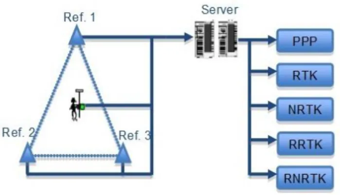
A new landslide deformation monitoring system that uses RRTK principles is being proposed. This new system is based on the server-based processing and two-way communication concept. The server-based RTK processing concept can be used in various RTK techniques (see Figure 1), namely precise point positioning (PPP), standard single-baseline RTK, network-RTK (NRTK), reversed RTK (RRTK), and reversed network RTK (RNRTK).74
Figure 1 Server-based RTK concept 74
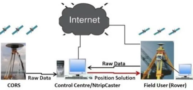
The last two techniques (RRTK and RNRTK) combine the server-based processing concept and two-way communication for the computation and transmission of the user’s accurate position. The reverse technique, which technically alters the one-way communication flow in the conventional RTK
technique, involves a two-way communication (Figure 2) which requires the field users to transmit their raw observations to a control centre for the computation of the position solution, after which the computed solution along with the quality control indicators are transmitted back to the field users. The architecture of the RRTK technique is depicted in Figure 3.
Figure 2 Two-way communication channel
Figure 3 The architecture of RRTK technique
The reverse approach based on combining the server-based processing concept and two-way communication has evolved for over five years now. But research opportunities offered by this approach is still not adequately exploited. The first practical implementation of RNRTK was made by Nippon GPS Solution in Japan.75 The development of new business model using the RNRTK approach, with the main goals of placing the control of the products with the service providers and enhancement of commercial value on the service was proposed.76
A new framework for RNRTK using distributed-computing technique was also proposed.77 The main goal of the framework was to integrate information and communication technologies, database and web technologies, and CORS network infrastructure, to upgrade the capability of the server to real-time data processing. These augmentations enable the servers to carry out data management and spatial analysis, and at the same time creating a platform for the users to efficiently utilise the results. A couple of years ago, an enhanced processing strategy which combines a single-baseline and a multiple rover network solution in a centralized (server-based) GNSS architecture, was developed.78 The main goal of this processing strategy was to use the shorter inter-receiver baselines to improve the results of single-epoch ambiguity resolution.
Some of the advantages of combining the server-based processing concept and two-way communication in the reverse approach include:77,78
- Control of the products is vested with the service providers. - Quality of service is guaranteed.
- Increased value on product, and enhancement of commercial value on the service.
- The user is relieved from the burden of complex computations.
- Low-cost receiver hardware can be deployed for field data streaming.
- Multiple users can be supported simultaneously. - The streaming of raw observations data from both the reference and roving stations to the control centre implies that all available information can be effectively utilized. The main advantages that the server-based processing technique can provide for landslide monitoring application are that the costs and tasks of the monitoring scheme will be drastically reduced, as low-cost receiver hardware will be utilised for real-time streaming of raw GPS measurements and complex algorithms and computations at the user end will be eliminated.
6.0 SUMMARY
Landslides have become one of the major causes of natural hazards worldwide, killing thousands of people and causing economic and social losses on private properties and public infrastructure. Over the past years, extensive research advances have been made in the monitoring of landslides, but major landslide events still occur, leaving behind untold social and economic damages.
The above review shows that GPS is increasingly being used in landslide monitoring applications. While most of the reviewed monitoring systems have high accuracy indices; however, the high cost of dual-frequency geodetic-grade receivers and the supporting firmware is limiting the use of RTK GPS for several monitoring applications.
The big challenge in landslide monitoring is how to reduce the cost of the monitoring scheme. The cost of monitoring landslides remains high, coupled with security concern and the prospect of losing the monitoring equipment during landslide event. Although great advances have been made in the development of several low-cost systems for landslide monitoring, these monitoring systems depend on receivers with expensive supporting software/firmware and which require complex computations at the user end. In order to address these problems, a new landslide deformation monitoring system is being proposed. In this new approach, the reverse RTK GPS combines the server-based processing concept and two-way communication for the computation and transmission of the user’s accurate position. The unique advantage of this monitoring approach is that low-cost receiver hardware can be deployed for field data streaming since the responsibility of complex computations is shifted from users (roving receivers) to the control centre. Apart from reducing the cost of the monitoring scheme, the approach can support multiple users simultaneously, and quality control indicators can be included in the position solutions.
Acknowledgements
The authors would like to express their sincere appreciation to Universiti Teknologi Malaysia and the Ministry of Science, Technology and Innovation (MOSTI) of Malaysia for the eScienceFund (4S074) given to this research project.
[1] D. M. Cruden. 1991. A simple definition of a landslide. Bulletin of the International Association of Engineering Geology - Bulletin de l'Association Internationale de Géologie de l'Ingénieur. 43(1) : 27–29. [2] F. Guzzetti. 2005. Landslide hazard and risk assessment. PhD
dissertation. University of Bonn. 389.
[3] F. Gutiérrez, M. Soldati, F. Audemard, D. Bălteanu. 2010. Recent advances in landslide investigation: Issues and perspectives.
Geomorphology. 124(3-4) : 95–101.
[4] J.-C. Flageollet. 1996. The time dimension in the study of mass movements. Geomorphology. 15(3-4) : 185–190.
[5] S. Q. Qin, J. J. Jiao, S. J. Wang. 2001. The predictable time scale of landslide. Bulletion of Engineering Geology and Environment. 59(4) : 307–312.
[6] T. Glade. 2003. Landslide occurrence as a response to land use change: A review of evidence from New Zealand. CATENA. 51(3–4) : 297–314.
[7] R. C. Sidle, D. Taylor, X. X. Lu, W. N. Adger, D. J. Lowe, W. P. de Lange, R. M. Newnham, J. R. Dodson. 2004. Interactions of natural hazards and society in Austral-Asia: Evidence in past and recent records. Quaternary International. 118–119(0) : 181–203.
[8] M. Geertsema, J. J. Clague, J. W. Schwab, S. G. Evans. 2006. An overview of recent large catastrophic landslides in northern British Columbia, Canada. Engineering Geology. 83(1–3) : 120–143. [9] USGS. 2013. Landslide events in 2013.
http://landslides.usgs.gov/recent/index.php?year= 2013&month. Accessed on May 27, 2013.
[10] C. Mekik, M. Arslanoglu. 2009. Investigation on accuracies of Real Time Kinematic GPS for GIS applications. Remote Sensing. 1(1) : 22–35.
[11] T. Takasu, A. Yasuda. 2009. Development of the low-cost RTK GPS receiver with the open source program package RTKLIB.
International Symposium on GPS/GNSS. International Convention
Centre Jeju, Korea.
[12] N. Brown, L. Troyer, O. Zelzer, J. van Cranenbroek. 2006. Advances in RTK and post processed monitoring with single frequency GPS.
Journal of Global Positioning Systems. 5(1-2) : 145–151.
[13] H. Y. Chen. 2001. A study on real-time medium-range carrier phase-based GPS multiple reference stations. UNISURV S-64. The University of New South Wales, Sydney, Australia. 182.
[14] C. A. Roberts. 2002. A continuous low-cost GPS-based volcano deformation monitoring system in Indonesia. UNISURV S-73. School of Surveying & Spatial Information Systems. The University of New South Wales, Sydney, Australia. 271.
[15] S. Verhagen, D. Odijk, P. J. G. Teunissen, L. Huisman. 2010. Performance improvement with low-cost multi-GNSS receivers. 5th
ESA Workshop on Satellite Navigation Technologies and European Workshop on GNSS Signals and Signal Processing (NAVITEC).
Noordwijk, 8-10 December.
[16] F. Yu. 2011. The feasibility of applying single-frequency receivers to slope monitoring. Geotechnical Special Publication. ASCE Library. 216 : 13–141.
[17] C. Rizos, J. van Cranenbroeck, V. Lui. 2010. Advances in GNSS-RTK for structural deformation monitoring in regions of high ionospheric activity. Proceedings of FIG Congress 2010. Sydney, Australia. 11-16 April.
[18] L. E. Aguado, C. O'Driscoll, P. Xia, K. Nurutdinov, C. Hill, P. O'Beirne. 2006. A low-cost, low-power Galileo/GPS positioning system for monitoring landslides. Proceedings of the 2006 Navitec, October 2006.
[19] J. Glabsch, O. Heunecke, S. Schuhbäck. 2009. Monitoring the Hornbergl landslide using a recently developed low cost GNSS sensor network. Journal of Applied Geodesy. 3 : 179–192.
[20] B. Lei, Q. Li, X. Li. 2011. Landslide monitoring system based on RTK technology. 4th International Workshop on Advanced
Computational Intelligence. Wuhan, Hubei, China, October 19–21.
[21] V. Sadarviana, E. Martoyo, H. Z. Abidin. 2006. The use of geodetic approach for identification of landslide’s characteristics and types (Case study: landslide zone in Ciloto, West Java, Indonesia).
Proceedings of the 2006 International Symposium and Exhibition on Geoinformation. September 19-21. Kuala Lumpur, Malaysia.
[22] M. Stewart, M. Tsakiri. 2001. The application of GPS to dam surface monitoring. Journal of Geospatial Engineering. 3(1) : 45–57. [23] L. Biagi, A. Dermanis. 2005. The treatment of time continuous GPS
observations for the determination of regional deformation parameters. Proceedings of the 2005 Geodetic Deformation Monitoring: From Geophysical to Engineering Roles. IAG
Symposium. March 17-19, Jaén, Spain. 83–94.
[24] A. Pirti, K. Gümüş, H. Erkaya, R. Gürsel, R. G. Hoşbaş. 2010. Evaluating repeatability of RTK GPS/GLONASS near/under forest environment. Croatian Journal of Forest Engineering. 31(1) : 23–33. [25] C. Ogaja, X. Li, C. Rizos. 2007. Advances in structural monitoring
with Global Positioning System technology: 1997-2006. Journal of
Applied Geodesy. 1(3) : 171–179.
[26] M. S. Rawat, V. Joshi, B. S. Rawat, K. Kumar. 2011. Landslide movement monitoring using GPS technology: A case study of Bakthang landslide, Gangtok, East Sikkim, India. Journal of
Development and Agricultural Economics. 3(5) : 194–200.
[27] G.-Q. Wang. 2012. Kinematics of the Cerca del Cielo, Puerto Rico landslide derived from GPS observations. Landslides. 9(1) : 117–130. [28] M. Yalçinkaya, T. Bayrak. 2002. GPS in landslides monitoring: A
case study from North Eastern Turkey. International Symposium on
GIS. Istanbul, Turkey.
[29] G. Wang, T. Soler. 2012. OPUS for horizontal subcentimeter-accuracy landslide monitoring: Case study in Puerto Rico and Virgin Islands region. Journal of Surveying Engineering. 138(3) : 11. [30] R. Xiao, X. He, L. Li. 2012. Continuous monitoring of landslide and
atmospheric water vapour using GPS: Applications in Pubugou Hydropower Resettlement Zone. Proceedings of the 2012 China Satellite Navigation Conference (CSNC). Lecture Notes in Electrical
Engineering. 305–313.
[31] E. Bertachini, A. Capitani, A. Capra, C. Castagnetti, A. Corsini, M. Dubbini, F. Ronchetti. 2009. Integrated surveying system for landslide monitoring, Valoria landslide (Appennines of Modena, Italy). FIG Working Week 2009. Eilat, Israel.
[32] S. Calcaterra, C. Cesi, C. Di Maio, P. Gambino, K. Merli, M. Vallario, R. Vassallo. 2012. Surface displacements of two landslides evaluated by GPS and inclinometer systems: A case study in Southern Apennines, Italy. Natural Hazards. 61(1) : 257–266.
[33] J. A. Coe, W. L. Ellis, J. W. Godt, W. Z. Savage, J. E. Savage, J. A. Michael, J. D. Kibler, P. S. Powers, D. J. Lidke, S. Debray. 2003. Seasonal movement of the Slumgullion landslide determined from Global Positioning System surveys and field instrumentation. July 1998-March 2002. Engineering Geology. 68 : 67–101.
[34] J. A. Gili, J. Corominas, J. Rius. 2000. Using Global Positioning System techniques in landslide monitoring. Engineering Geology. 55(3) : 167–192.
[35] J.-P, Malet, O. Maquaire, E. Calais. 2002. The use of Global Positioning System techniques for the continuous monitoring of landslides: Application to the Super-Sauze earthflow (Alpes-de-Haute-Province, France). Geomorphology. 43 : 33–54.
[36] J. L. Moss. 2000. Using the Global Positioning System to monitor dynamic ground deformation networks on potentially active landslides. International Journal of Applied Earth Observation and
Geoinformation. 2(1) : 24–32.
[37] V. Rizzo. 2002. GPS monitoring and new data on slope movements in the Maratea Valley (Potenza, Basilicata). Physics and Chemistry of
the Earth. Parts A/B/C. 27(36) : 1535–1544.
[38] F. Tagliavini, M. Mantovani, G. Marcato, A. Pasuto, S. Silvano. 2007. Validation of landslide hazard assessment by means of GPS monitoring technique - A case study in the Dolomites (Eastern Alps, Italy). Natural Hazards and Earth System Sciences. 7 : 185–193. [39] P. Mora, P. Baldi, G. Casula, M. Fabris, M. Ghirotti, E. Mazzini, A.
Pesci. 2003. Global Positioning Systems and digital photogrammetry for the monitoring of mass movements: Application to the Ca' di Malta landslide (Northern Apennines, Italy). Engineering Geology. 68(1–2) : 103–121.
[40] M. Peyret, Y. Djamour, M. Rizza, J. F. Ritz, J. E. Hurtrez, M. A. Goudarzi, H. Nankali, J. Chéry, K. Le Dortz, F. Uri. 2008. Monitoring of the large slow Kahrod landslide in Alborz mountain range (Iran) by GPS and SAR interferometry. Engineering Geology. 100(3–4) : 131– 141.
[41] H. Rott, T. Nagler. 2006. The contribution of radar interferometry to the assessment of landslide hazards. Advances in Space Research. 37(4) : 710–719.
[42] G. Wang, D. Philips, J. Joyce, F. Rivera. 2011. The Integration of TLS and continuous GPS to study landslide deformation: A Case study in Puerto Rico. Journal of Geodetic Science. 1(1) : 25–34. [43] V. Janssen, C. Rizos. 2003. A mixed-mode GPS network processing
approach for deformation monitoring applications. Survey Review. 37(287) : 2–19.
[44] C. Squarzoni, C. Delacourt, P. Allemand. 2005. Differential single-frequency GPS monitoring of the La Valette landslide (French Alps).
Engineering Geology. 79(3–4) : 215–229.
[45] F. K. Brunner, K. Macheiner, H. Woschitz. 2007. Monitoring of deep-seated mass movements. Proceedings of the 3rd International
Conference on Structural Health Monitoring of Intelligent Infrastructure. British Columbia, Canada.
[46] K. Hastaoglu, D. Sanli. 2011. Monitoring Koyulhisar landslide using rapid static GPS: A strategy to remove biases from vertical velocities.
Natural Hazards. 58(3) : 1275–1294.
[47] G. Wang. 2011. GPS landslide monitoring: Single Base vs. Network Solutions - A case study based on the Puerto Rico and Virgin Islands Permanent GPS Network. Journal of Geodetic Science. 1(3) : 191– 203.
[48] Z. Othman, W. A Wan Aziz, A. Anuar. A. 2011. Evaluating the performance of GPS survey methods for landslide monitoring at Hillside Residential Area: Static vs Rapid Static. IEEE 7th
International Colloquium on Signal Processing and its Applications.
George Town, Penang.
[49] Z. Othman, W. A. Wan Aziz, A. Anuar. 2011b. Landslide monitoring at Hillside Residential Area Using GPS technique: Static vs. RTK Network. Joint International Symposium & Exhibition on
Geoinformation (ISG) 2011 and ISPRS 2011. Shah Alam Convention
Centre, Selangor.
[50] 3D Tracker User Manual. 2009. Published by Applied Geomechanics. San Francisco, USA. 95.
[51] G. Gassner, A. Wieser, F. K. Brunner. 2002. GPS software development for monitoring of landslides. Proceedings of the 2002 FIG XXII International Congress. Washington, D. C. USA, April 19-26.
[52] F. K. Brunner, H. Hartinger, B. Richter. 2000. Continuous monitoring of landslides using GPS: A progress report. In Proceedings of the Geophysical Aspects of Mass Movements. Austrian Academy of
Sciences. Vienna. 75–88.
[53] H. Hartinger, F. K. Brunner. 1999. Development of a system of landslide motions using GPS. Proceedings of the 9th FIG Symposium on Deformation Monitoring. Olsztyn, Poland. 27-30 September. 29– 38.
[54] R. Klostius, S. Schön, F. Zobl, F. K. Brunner. 2005. Online monitoring of landslides using GPS. Geophysical Research Abstracts. 7 : 02983.
[55] G. Wübbena, A. Bagge, G. Boettcher, M. Schmitz, P. Andree. 2001. Permanent object monitoring with GPS and 1 millimeter accuracy. Paper presented at the International Technical Meeting, ION GPS-01. September 11-14, 2001. Salt Lake City, Utah.
[56] R. Jäger, F. González. 2005. GNSS/GPS/LPS based Online Control and Alarm System (GOCA) - Mathematical models and technical realization of a system for natural and geotechnical deformation monitoring and hazard prevention. Proceedings of the 2005 Geodetic Deformation Monitoring: From Geophysical to Engineering Roles,
IAG Symposium. Jaén, Spain, March 17-19.
[57] R. Jäger, S. Kälber. 2004. GNSS/GPS/LPS based Online Control and Alarm System (GOCA) - A geodetic contribution to natural and geotechnical deformation monitoring and hazard prevention. Proceedings of the 2004 Workshop on Environmental Problems and Ecological Safety, Germany, Wiesbaden, September 29 - October 1. [58] C. D. Ince, M. Sahin. 2000. Real-time deformation monitoring with
GPS and Kalman filter. Earth Planet Space. 52 : 837–840.
[59] J. van Cranenbroeck, L. Troyer. 2004. Leica GPS Spider for deformation monitoring. Poster presented at 1st FIG International Symposium on Engineering Surveys for Construction Works and Structural Engineering/Workshop on Measurements and Analysis of Cyclic Deformations and Structural Vibrations. The University of Nottingham, United Kingdom. 28 June - 1 July.
[60] J. V. Andersson. 2008. A complete model for displacement monitoring based on undifferenced GPS observations. Doctoral
thesis. Division of Geodesy. Geodesy Report No. 1066. Royal
Institution of Technology(KTH), Stockholm, Sweden. 172.
[61] A. Szostak-Chrzanowski, A. Chrzanowski. 2008. Interdisciplinary approach to monitoring, analysis, and modelling of deformations.
Electronic Journal of Polish Agricultural Universities. 11(2) : 29.
[62] I. Petrovski, S. Kawaguchi, H. Torimoto, M. Asako, T. Chachin, K. Okano. 2000. Lamos-BohsaiTM: Landslide monitoring system based
on high-speed sequential analysis for inclination. Proceedings of the 2000 National Technical Meeting of the Institute of Navigation. January 26-28. Pacific Hotel Disneyland, Anaheim, California, USA. [63] ClimChAlp. 2008. Slope monitoring methods: A state of the art
report. Climate Change, Impacts and Adaptation Strategies in the Alpine Space. Work Package 6. Munich. 28.2.2008. 165.
[64] F. C. Dai, C. F. Lee. 2002. Landslide characteristics and slope instability modelling using GIS. Lantau Island, Hong Kong.
Geomorphology. 42(3-4) : 213–228.
[65] K. Thuro, T. Wunderlich, O. Heunecke. 2007. Development and testing of an integrative 3D early warning system for alpine instable slopes (alpEWAS). In: Geotechnologien (2007): Early Warning Systems in Earth Management. Science Report. (10):101–112. [66] C. Arnhardt, K. Asch, R. Azzam, R. Bill, T. M. Fernandez-Steeger, S.
D. Homfeld, A. Kalash, F. Niemeyer, H. Ritter, M. Toloczyki, K. Walter. 2007. Sensor based landslide early warning system - SLEWS: Development of a geoservice infrastructure as basis for early warning systems for landslides by integration of real-time sensors.
Geotechnologien Science Report. 10 : 75–88.
[67] S. Gabriele, G. D’Aquila, F. Chiaravalloti. 2009. A distributed real-time monitoring system for landslide hazard and risk assessment. Proceedings of the 2009 Geospatial Visual Analytics: Geographical Information Processing and Visual Analytics for Environmental Security. NATO Science for Peace and Security Series C: Environmental Security. 2009. Part 7 : 387–394.
[68] A. M. Kandawasvika. 2009. On interoperable management of multi-sensors in landslide monitoring applications. PhD thesis, Universität der Bundeswehr München, Germany. 172.
[69] J. Travelletti, C. Delacourt, P. Allemand, J.-P Malet, J. Schmittbuhl, R. Toussaint, M. Bastard. 2012. Correlation of multi-temporal ground-based optical images for landslide monitoring: Application, potential and limitations. ISPRS Journal of Photogrammetry and
Remotes Sensing. 70 (2012) : 39–55.
[70] J. Bond, A. Chrzanowski, D. Kim. 2008. Bringing GPS into harsh environments for fully automated deformation monitoring. GPS
Solutions. 12:1–11.
[71] J. Bond, D. Kim, A. Chrzanowski, A. Szostak-Chrzanowski. 2007. Development of a fully automated. GPS based monitoring system for disaster prevention and emergency preparedness: PPMS+RT. Sensors. 7 : 1028–1046.
[72] Y. Feng, J. Wang. 2008. GPS RTK performance characteristics and analysis. Journal of Global Positioning System. 7(1) :1–8.
[73] Y. Feng, J. Wang. 2007. Exploring GNSS RTK performance benefits with GPS and virtual Galileo measurements. Proceedings of the 2007 National Technical Meeting of the Institute of Navigation. San Diego, CA, January 22-24. 218–226.
[74] Y. Feng, C. Rizos, M. Higgins, S. Lim, M. Tang. 2009. Developing regional precise positioning services using the legacy and future GNSS receivers. Journal of Global Positioning Systems. 8(1): 17–25. [75] M. Kanzaki. 2006. Inverted RTK System and its applications in
Japan. Proceedings of the 2006 12th IAIN Congress and 2006
International Symposium on GPS/GNSS. Jeju, Korea, 18-20 October.
455–458.
[76] C. Rizos. 2007. Alternatives to current GPS-RTK services and some implications for CORS infrastructure and operations. GPS Solutions. 11(3) : 151–158.
[77] S. Lim, C. Rizos. 2008. A conceptual framework for server-based GNSS operations. Journal of Global Positioning Systems. 7 (2): 125– 132.
[78] N. Zinas, A. Parkins, M. Ziebart. 2012. Improved network-based single-epoch ambiguity resolution using centralized GNSS network processing. GPS Solutions. 23 February 2012. 1-11, doi: 10.1007/s10291-012-0256-x.