YAŞAR UNIVERSITY
GRADUATE SCHOOL OF NATURAL AND APPLIED SCIENCES MASTER THESIS
THE “MANHATTAN” OF İZMİR?
FOLKART TOWERS AND URBAN TRANSFORMATION
Cansu KARAKIZ
Thesis Advisor: Prof. Dr. Gülsüm Baydar
Department of Architecture Presentation Date: 18.01.2017
Bornova-İZMİR 2017
iii ABSTRACT
THE “MANHATTAN” OF İZMİR? FOLKART TOWERS AND URBAN TRANSFORMATION
KARAKIZ, Cansu MSc in Architecture
Supervisor: Prof. Dr. Gülsüm Baydar
January 2017, 90 pages
Since 2006, the urban regeneration of Bayraklı district is announced to be İzmir’s “Manhattan” by local newspapers. The 10 years long urban transformation process continues to date with the rapid construction of high rise buildings. Folkart Towers, which were completed in 2014, Pioneer this process, which has gained speed in the past two years. The Towers are distinguished from their immediate surroundings by their sheer height which dominates the urban silhouette. They are introduced as the new symbol of İzmir in various commercials and take place in the city’s representations in films and photographs.
This thesis analyzes the urban transformation of the immediate neighborhood of the Towers by focusing on the latter. The aim is to reveal the discrepancies between the discourses of the planners and promotional images and everyday life in the area.
Keywords: Urban Regeneration, Urban Image, Urban Symbol, Spatial Practices,
iv ÖZET
İZMİR’İN”MANHATTAN’I”?
FOLKART TOWERS VE KENTSEL DÖNÜŞÜM Cansu KARAKIZ
Yüksek Lisans Tezi, Mimarlık Bölümü Tez Danışmanı: Prof. Dr. Gülsüm BAYDAR
Ocak 2017, 90 sayfa
2006’dan itibaren Bayraklı ilçesinin kentsel dönüşümü yerel gazeteler tarafından bölgenin İzmir’in “Manhattan”ı olacağı şeklinde duyurulmaktadır. Onuncu yılına ulaşan kentsel dönüşüm süreci güncel olarak çok katlı yapıların hızlı inşaatları ile devam etmektedir. 2014 yılında inşası tamamlanan Folkart Towers, özellikle son iki yıl içerisinde hızlandırılan sürecin öncüsü durumundadır. Farklı ölçeğiyle civardaki düşük profilli kent dokusundan ayrılır ve şehir silüetinde yerini alır. Reklamlarında İzmir’in yeni sembolü olarak tanıtılır ve film ve fotoğraflardaki güncel şehir temsillerinde de boy gösterir.
Bu tez bölgedeki yeniden yapılanmayı Folkart Towers’a odaklanarak inceler ve sunulan imgelerle bölgedeki gündelik hayat pratiklerinin çelişkilerini ortaya çıkarmayı hedefler.
Anahtar sözcükler: Kentsel Dönüşüm, Kent İmgesi, Kent Sembolü, Mekansal
v
ACKNOWLEDGEMENTS
First of all, I thank to my supervisor Prof. Dr. Gülsüm Baydar for her patience and support which helped me to improve the quality of this research. Without her guidance and motivation, I could not overcome the several obstacles that I had been facing through the process. More importantly, I am grateful to her contributions that have helped me to develop a systematical thinking which I will benefit not only in my academic studies, but also in my whole life.
I would also like to thank Yasar University which funds the research conducted for this thesis (project no: BAP041) under the the BAP (Scientific Research Projects) scheme, upon approval by the Project Evaluation Commission (PDK).
My final thanks go to my parents, Asuman Karakız and Ahmet Karakız for their lifelong love, support and patience; and also Taner Kapan, for his moral support and endless encouragement.
Cansu KARAKIZ İzmir, 2017
vi
vii TABLE OF CONTENTS Page ABSTRACT iii ÖZET iv ACKNOWLEDGEMENTS v TEXT OF OATH vi
TABLE OF CONTENTS vii
INDEX OF FIGURES x
INDEX OF TABLES xiv
INDEX OF ABBREVIATIONS xv
1 INTRODUCTION 1
1.1 Aim 2
1.2 Scope 4
1.3 Method 5
2 ON THE GROUND: TRANSFORMING THE URBAN CONTEXT 10
2.1 Historical Context: Planning Modern İzmir 11
2.2 Urban Regeneration in Turkey 18
viii
3 IN DISCOURSE: CONSTRUCTING AN IMAGE 26
3.1 Construction of Urban Images 26
3.2 İzmir’s Symbols and Folkart Towers 28
3.2.1 Historical Constructions of İzmir’s Symbols 28
3.2.2 Representations of Folkart Towers 38
4 IN PRACTICE: RE-MAKING EVERYDAY LIFE 46
4.1 Residential Areas 46
4.1.1 Folkart Towers 46
The Slum Neighborhood 50
4.1.2
4.1.2.1 Social Life 51
4.1.2.2 Perception of Folkart Towers 52
4.1.2.3 Environmental Changes 54
4.1.2.4 Future Projections 54
4.2 Business and Commercial Functions 55
Manas Boulevard 55
4.2.1
4.2.1.1 Economic Transformations 56
4.2.1.2 Perception of Folkart Towers 57
Folkart Towers 58
ix
4.2.2.1 Perception of Folkart Towers 59
4.2.2.2 Perception of Urban Regeneration and Future Projections 62
Warehouses and Mixed Use Development 64
4.2.3
4.2.3.1 Economic Transformations 65
4.2.3.2 Environmental and Infrastructural Problems 66
4.2.3.3 Perception of Folkart Towers 67
4.2.3.4 Future Projections 69
5 CONCLUSION 71
BIBLIOGRAPHY 73
CURRICULUM VITEA 85
APPENDIX 1 1925 – 1953 -1973 İZMİR PLANS COMPARISON 86
APPENDIX 2 FoLKART YAPI’S PUBLICITY MEDIUMS of 2011 90
x
INDEX OF FIGURES
Figure 1 Folkart Towers, from Salhane İZBAN Station (Photograph by author, 2015) 3
Figure 2 Folkart Towers, functional distribution (Illustration by author) 3
Figure 3 The area of research (Yandex Map image edited by the author) 6
Figure 4 İzmir’s fire incendiee (fire zone) in 1922 (Yılmaz, 2004, 122) 12
Figure 5 Danger and Prost’s plan for İzmir, 1925 (Atay, 1998, 181) 13
Figure 6 Aru’s plan for İzmir, 1953 (Bilsel, 2009, 12) 14
Figure 7 Salhane, detail from Aru’s plan for İzmir, 1953 (İGMM’s archive) 15
Figure 8 Salhane, detail from plan of İzmir, 1973 (İGMM’s archive) 16
Figure 9 Salhane, detail from plan of İzmir, 1989, the quarter identified as MİA
(CBD) (İGMM’s archive) 17
Figure 10 İzmir’s urban regeneration map of 2016 (Google Maps image edited by the
author) 21
Figure 11 İzmir’s New City Center, İGMM’s 1/5000 master plan, 2003 (Erdik and
Kaplan, 2009) 22
Figure 12 İzmir’s New City Center, within the zones of Johan Brandi’s proposal, 2001 (Mimarlar Odası İzmir Şubesi: Ege Mimarlık, 2001/4 – 2002/1) 23 Figure 13 Johan Brandi’ proposal for New City Center for İzmir, site plan, 2001
xi
Figure 14 Clock Tower, İzmir, 1939 (Can, 2007, 123) 29
Figure 15 Turkish flags on the Clock Tower, after 1950 (Taşkıran, 2010, 8) 30
Figure 16 Front page, İzmir City Guide, 1981 (Nadir Kitap, 2016) 31
Figure 17 İGMM’s current logo (İzmir Büyükşehir Belediyesi, 2016) 31
Figure 18 The image of the Clock Tower imprinted on sand; a clock with the image of the Clock Tower; a cologne bottle in the form of the Clock Tower (Sınırsızal.com,
2016; Evmanya, 2016; Nehir Süs, 2016) 31
Figure 19 Clock Tower (Wowturkey, 2004) 32
Figure 20 Screenshot, Uyanık Kardeşler, 14:57sec (Saner, 1974) 34
Figure 21 Kordon, İzmir Guide, 2007 (İzmir Ticaret Odası, 7) 34
Figure 22 “Kordon”, Wojtek Laskı, 2015 (Arkas Sanat Merkezi, 2015, 86-87) 34
Figure 23 Cumhuriyet Square (Wowturkey, 2006) 35
Figure 24 Kültürpark, unknown date (Kültürpark İzmir, 2016) 36
Figure 25 Varyant, İzmir, late 1950s (Ezel, 2012) 37
Figure 26 Screenshot, Ateş Böceği, 42:40 sec (Seden, 1975) 37
Figure 27 Asansör and Dario Moreno Street with restored old İzmir houses (İzmir
Ticaret Odası, 2007, 18) 38
Figure 28 The image on top of “Yeni Reklam Filmi Folkart Towers’ı İkonlaştırıyor” (The New Advertisement Film Iconizes Folkart Towers) titled new (Ege’nin Sesi,
2013) 39
xii
Figure 30 Screenshot, Folkart Towers’ commercial film, 0:55 sec (Youtube, 2012) 40
Figure 31 Screenshot, Folkart Towers’ commercial film, 1:01 sec (Youtube, 2012) 40
Figure 32 Screenshot, Folkart Towers’ commercial film, 0:24 sec (Youtube, 2013) 41
Figure 33 Screenshot, Folkart Towers’ commercial film, 0:33 sec (Youtube, 2013) 41
Figure 34 Screenshot, Folkart Towers’ commercial film, 0:43 sec (Youtube, 2013) 42
Figure 35 Screenshot, Folkart Towers’ commercial film, 2015, 0:23 sec (Youtube,
2015) 42
Figure 36 Screenshot, Folkart Towers’ commercial film, 2015, 0:39 sec (Youtube,
2015) 43
Figure 37 Screenshot, Folkart Towers’ commercial film, 2015, 0:49 sec (Youtube,
2015) 43
Figure 38 “Bayraklı”, Nilgün Özdemir, 2016 (Arkas Sanat Merkezi, 2015, 106) 44
Figure 39 “Kadifekale”, Muhammad Jahangir Khan, 2016 (Arkas Sanat Merkezi,
2015, 72) 45
Figure 40 Screenshot, Kulelerin Gölgesindeki Adalet, 2016 (Youtube, 2016, 3:27 sec) 45
Figure 41 Interviewed houses, zone B (Yandex Map image edited by the author) 47
Figure 42 Residences’ lobby of Tower B (Folkart Towers, 2016) 48
Figure 43 The slum neighborhood (Photograph by author, 2015) 50
xiii
Figure 45 Screenshot, Kulelerin Gölgesindeki Adalet, 2016 (Youtube, 2016, 2:37 sec) 52
Figure 46 Manas Boulevard (Photograph by author, 2015) 55
Figure 47 Business and commercial spaces where interviews were carried out in zone
A (Yandex Map image edited by the author) 56
Figure 48 Folkart Bazaar (Photograph by author, 2015) 59
Figure 49 Business and commercial spaces where interviews were conducted in zone
B (Yandex Map image edited by the author) 59
Figure 50 The slum neighborhood, from Folkart Gallery (Photograph by author,
2015) 63
Figure 51 The warehouses, zone C (Photograph by author, 2015) 64
Figure 52 Locations of the business and commercial spaces where interviews were
xiv
INDEX OF TABLES
xv
INDEX OF ABBREVIATIONS
CBD Central Business District
İGMM İzmir Greater Metropolitan Municipality (İzmir Büyükşehir
Belediyesi)
İPDIUR İzmir Provincial Directorate of Infrastructure and Urban Regeneration (İzmir Alt Yapı ve Kentsel Dönüşüm İl Müdürlüğü)
NCC New City Center (Yeni Kent Merkezi)
1 1 INTRODUCTION
In 2006, İzmir’s local newspaper Yeni Asır, proudly announced plans for the Manhattanization of Bayraklı – a central district in İzmir. Accordingly, new master plans were being considered by the commission in charge of the development of public works (İmar ve Bayındırlık Komisyonu) following the proposal of Aziz Kocaoğlu, the mayor of the Greater Metropolitan Municipality (henceforth İGMM) (Yeni Asır, 2006). The regeneration process of the district began in 2010 (Milliyet.com.tr Ege, 2010). The following years saw a number of changes to the plans. Currently Bayraklı, particularly its Salhane quarter witnesses the construction of several eye-catching skyscrapers amidst its low-rise profile of mostly residential buildings. Folkart Towers is one of the earliest projects in the area and the most conspicuous one to date.
Manhattanization sounds like an unusual characterization for a relatively small city like İzmir. In fact the earliest use of the phrase ‘to Manhattanize’ is found in 1930 in Webster's New International Dictionary of the English Language, and the verb is defined as “to make similar in character or appearance to Manhattan or its inhabitants; specifically to fill (a city or skyline) with tall buildings so that it resembles Manhattan Island” (Oxford Dictionaries, 2016). The definition of the noun Manhattanization on the other hand, was included in Encyclopaedia Britannica in 1970 as “the process of making or becoming similar in character or appearance to Manhattan” (Oxford Dictionaries, 2016). However, urban anthropologist Elizabeth Greenspan states that the colloquialism refers to a different phenomenon nowadays (2013). According to her, as well as constituting dense clusters of commercial skyscrapers, “the new meaning of ‘Manhattanization’ is turning a city into a playground for the wealthiest inhabitants, even as it forgets about the poorest”.
In conformity with Greenspan’s statement, Bayraklı’s Salhane quarter has been a popular investment area for private firms which have been undertaking skyscraper constructions since 2011, targeting upper-income customers. Folkart Towers mark the beginning of the so-called Manhattanization process in the area. The Towers’ marketing campaign extensively publicizes the Towers as the new symbol of İzmir. In the promotion of the regeneration plans by the urban administration and the
2
Folkart Towers by profit making agencies, little attention is paid to their impact on the existing urban environment and its inhabitants.
This study provides an analysis of Folkart Towers in the context of Salhane’s urban transformation. It surfaces the discrepancies between the discourses of administrative and commercial bodies and the everyday practices of the neighborhood’s inhabitants.
1.1 Aim
Urban regeneration projects have become prevailing modes of production of urban space since the 1980s (Penpecioğu, 2013, 165). Their popularity began to rise in Turkey particularly since 2002, following the election of Justice and Development Party (Adalet ve Kalkınma Partisi, henceforth JDP) which has remained in power to date (Balaban, 2011, 19). Although academic debates on urban regeneration proliferated since then, most took place at the theoretical level rather than focusing on case studies (Gündoğan, 2006; Kurtulş, 2006; Ataöv and Osmay, 2007; Şişman and Kibaroğlu, 2009).
Among the few case studies, those which focus on İzmir, examine Kadifekale, as the first completed disrict-based urban regeneration project conducted by the İzmir Greater Metropolitan Municipality (Mutlu, 2009; Demirtaş-Milz, 2013; Eranıl Demirli, Tuna Ultav, Demirtaş-Milz, 2015). The studies involving Bayraklı’s transformation, on the other hand, concentrate on the political aspects and decision making processes of the project rather than offering critical discourse analyses of media representations and everyday practices (Penpecioğlu, 2012; Penpecioğlu, 2013; Penpecioğlu, 2016).
As one of the first completed skyscraper projects in Salhane, Folkart Towers are distinguished from their immediate surroundings (Figure 1). The Towers include commercial functions, offices and residences which target high-income groups (Figure 2). The aim of the present work is to reveal the discrepancies between the spatial policies of decision making institutions, media representations of Folkart Towers which declare the latter as the new symbol of İzmir, and the spatial practices that surround the Towers.
3
Figure 1 Folkart Towers, from Salhane İZBAN Station (Photograph by author, 2015)
4 1.2 Scope
The contents of this analysis are framed by three interrelated sections respectively entitled: “On the ground: transforming the urban context”, “In discourse: constructing an image” and “In practice: re-making everyday life”.
The first section focuses on the historical context of İzmir’s urban structure and Salhane’s transformation in the larger context of modern urbanization processes in Turkey. A brief survey of such processes in three largest cities, İstanbul, Ankara and İzmir show how the notion of urban regeneration was set as a political strategy by administrative bodies. The final part of this section is a detailed analysis of Salhane as the new business center of İzmir.
The second section, In Discourse: Constructing an Image, investigates the construction of urban images in the context of the notion of city marketing. Following the historical constructions of İzmir’s symbols including the Clock Tower, Kordon, Cumhuriyet Square, Kültürpark, Varyant and Asansör, the second part of this section focuses on the representations of Folkart Tower. A critical reading of the latter’s images in advertisement films and art projects reveal the selective choice of specific themes in the construction of the city’s new image.
The third section, In Pracice: Re-making Everyday Life focuses on the effects of the urban regeneration process on spatial practices. It is based on field observations and half structured in depth interviews conducted with the inhabitants of Folkart Towers and their neighboring spaces.
The thesis concludes by stating how the results of urban regeneration implementations in Salhane are not consistent with the planners’ discourses and images, which are presented by the media.
5 1.3 Method
The research method of the following study includes primary and secondary sources. Primary sources consist of on-site observations, and half structured in-depth interviews, urban and regeneration plans for İzmir, local news articles regarding Salhane’s regeneration and Folkart Towers, and media images of the latter. Secondary sources include historical and theoretical studies on the production of space, and the concepts of Manhattanization and gentrification in the context of globalization.
On-site observations and half structured in-depth interviews played a significant role in understanding the impact of the urban regeneration process on the everyday lives of the inhabitants. The interviews were conducted with the designers of the Towers, officials of Bayraklı municipality and the local headman besides the residents of Salhane.
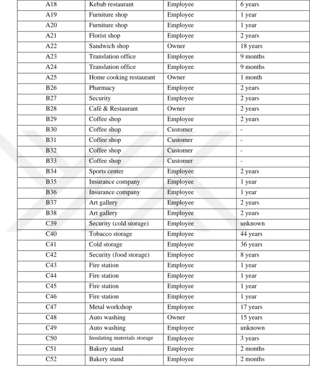
The research area includes residences, commercial spaces and warehouses, and the interviewees are divided into four groups according to their locations. The owners and the employees of the business and commercial spaces on Manas Boulevard that face the Towers constitute group A. The residents and the employees of the Folkart Towers constitute group B. The owners and the employees of the commercial spaces that surround the Towers constitute group C, and the residents of the squatter houses that face the Towers constitute group D (Figure 3) (Table 1).
6
Figure 3 The area of research (Yandex Map image edited by the author)
Location& Reference Function Position Duration of use/service
B1 Residence Real estate broker -
B2 Residence Owner 2 years
B3 Residence Owner 2 years
B4 Residence Owner 1.5 month
D5 Residence Owner unknown
D6 Residence Owner 15 years
D7 Residence Owner 20 years
D8 Residence Owner 13 years
D9 Residence Owner 27 years
D10 Residence Owner 22 years
D11 Residence Owner 22 years
D12 Residence Guest -
D13 Residence Guest -
D14 Residence Owner 20 years
A15 Bakery Owner 2 years
A16 Print house Employee 4 years
A17 Auto body shop Owner 24 years
A B C D
7
A18 Kebab restaurant Employee 6 years
A19 Furniture shop Employee 1 year
A20 Furniture shop Employee 1 year
A21 Florist shop Employee 2 years
A22 Sandwich shop Owner 18 years
A23 Translation office Employee 9 months
A24 Translation office Employee 9 months
A25 Home cooking restaurant Owner 1 month
B26 Pharmacy Employee 2 years
B27 Security Employee 2 years
B28 Café & Restaurant Owner 2 years
B29 Coffee shop Employee 2 years
B30 Coffee shop Customer -
B31 Coffee shop Customer -
B32 Coffee shop Customer -
B33 Coffee shop Customer -
B34 Sports center Employee 2 years
B35 Insurance company Employee 1 year
B36 Insurance company Employee 1 year
B37 Art gallery Employee 2 years
B38 Art gallery Employee 2 years
C39 Security (cold storage) Employee unknown
C40 Tobacco storage Employee 44 years
C41 Cold storage Employee 36 years
C42 Security (food storage) Employee 8 years
C43 Fire station Employee 1 year
C44 Fire station Employee 1 year
C45 Fire station Employee 1 year
C46 Fire station Employee 1 year
C47 Metal workshop Employee 17 years
C48 Auto washing Owner 15 years
C49 Auto washing Employee unknown
C50 Insulating materials storage Employee 3 years
C51 Bakery stand Employee 2 months
C52 Bakery stand Employee 2 months
8
The interviews, which were held with 52 subjects, aimed to clarify the differences between former and existing lifestyles of the area’s users and reveal their future expectations within the framework of the following questions: What are the changes in the everydaylife of the area’s users since the construction of Folkart Towers? Has the transformation of the urban context met the residents’ desires and expectations for their future? What are the residents’ views on naming Folkart Towers as the new urban symbol?
Regeneration plans for İzmir provided information on the position and Bayraklı and Salhane in the larger context of planning processes. Local news articles on Salhane and Folkart Towers helped me to understand how the regeneration process was promoted and publicized.
Finally, the theoretical framework of the study is informed by renowned urban theorists Henri Lefebvre’s and Edward Soja’s works. Lefebvre’s framework of spatial analysis distinguishes between perceived, conceived, and lived spaces. According to him, perceived space or alternatively spatial practices is “directly lived through its associated images” (Lefebvre, 2007, 39) by its inhabitants and users. Conceived space or representations of space are associated with professionals such as urban planners, architects and landscape architects “who identify what is lived and what is perceived with what is conceived” (Lefebvre, 2007, 38-39). Maps, plans and models are its physical manifestations. Lived space on the other hand, is alternatively called representational space, which Lefebvre describes as embracing “production and reproduction, and the particular locations and spatial sets characteristic of each social formation” (Lefebvre, 2007, 33).
Urban theorist Edward Soja, on the other hand proposes a triple dialectic of space, which is partially inspired by the work of Lefebvre. His triad consists of Firstspace, Secondspace and Thirdspace. His definition of Firstspace includes mappable elements in space. Secondspace is the conceptualization of the Firstspace and can be associated with Lefebvre’s conceived space. Soja’s Secondspace includes representations of space in art, advertisements and any other media. Thirdspace on the other hand, should be understood through the first two, and it includes both material and mental spaces and can be associated with Lefebvre’s perceived space. However, Soja does not want to fix any definition of Thirspace. According to him, it is the space that we give meaning to; therefore, it always changes. His intention is to
9
provide a way for “thinking about and interpreting socially produced space” (Borch, 2002, 113), in order not to achieve a final conclusion but a beginning for further exploration.
Both Lefebvre and Soja view space as a social construction where meaning is produced. Following their line of thinking, this study consists of three sections which examine the transformation of Salhane by focusing on Folkart Towers.
10
2 ON THE GROUND: TRANSFORMING THE URBAN CONTEXT Cities are not static entities but are in continuous transformation due to changing social, economic and cultural conditions (Gündoğan, 2006; Türkiye, 2013). Transformation from industrial to information society, Fordist to flexible production, modernist to post-modernist conditions, and nation states to global networks has significantly affected urban formations (Türkiye, 2013). The global phenomenon of urban regeneration can be understood as the product of such phenomena whichurban theorist İlhan Tekeli calls a “structural transformation” (Tekeli, 2015, 309). However, the term has also been narrowly used to mean pulling down old buildings in order to build new ones (Türkiye, 2013).
In its broadest sense, urban regeneration is “the process of improving derelict or dilapidated districts of a city, typically through redevelopment” (Oxford Dictionaries, 2016).1 Turkish Language Association explains the term as improving a city by demolishing the buildings, which are not built according to the city’s development plans, and redeveloping the city by building planned housing estates (Türk Dil Kurumu, 2016).
These definitions emphasize the improvement of the physical structure which inevitably involves economic development (Weaver, 2001). In fact the economic advantages of urban regeneration for all citizens are persistently accentuated in neo-liberal discourses, which hardly include conflicting interests between different agents that are involved in the process (Ataöv and Osmay, 2007; Gündoğan, 2006; Tekeli, 2015). The latter are based on the generation of a rent-gap, which is the difference between the present land value of a plot and its potential value (Smith, 1987, 462). The rent gap is the main economic reason of gentrification which is the replacement of city centers’ low-income groups of former users with members of the middle-class. Hence urban regeneration involves “the transformation of inner-city working-class and other neighborhoods to middle and upper-middle class residential, recreational, and other uses” and “is clearly one means by which the rent gap can be closed wholly
1
The terms urban reconstruction, urban revitalization, urban renewal, urban redevelopment, and urban regeneration are used interchangeably in contemporary sources (Penpecioğu, 2016). This thesis uses urban regeneration as it is the most frequently used term since 1990s.
11
or partially” (Smith, 1987). Renowned urban theorist David Harvey claims that the popularity of urban regeneration projects increase in proportion to the desire of the wealthy segments of society who live in the suburbs, to return to city centers (Milliyet.com.tr, 2012b).
Spatial interventions, which transform the cities’ urban characteristics, have become tools for economic and social control in different parts of the world including such diverse areas as Rio de Genaro, New York, Paris, London, İstanbul, Mumbai and Kuala Lumpur. İzmir, as the third largest city of Turkey, is at the beginning of a process which emulates urban transformation processes of global cities. Within this context Bayraklı is being gentrified by the local authorities with the collaboration of private firms. Hence this chapter examines the gentrification of the area in relation to economic and political processes that effect urban regeneration in Turkey.
2.1 Historical Context: Planning Modern İzmir
Urbanism as a new science of 20th century was an excellent tool for the new Turkish Republic in the “creation of a physical urban frame, the setting of a network, equipment and symbols and an urban image that would support the modern society that the Republic aimed to achieve” (Bilsel, 1996, 13). Western planning approaches, mostly German and French models shaped the principles of the early Republican cities. The new capital, Ankara; the most populated city, İstanbul; and the second most populated city İzmir, were reconstructed to represent the modern image of the new Republic (Bilsel, 1996; Bozdoğan 2001).
İzmir provided fertile ground for such an intervention after a big fire which destroyed a significant portion the city in 1922. Most importantly, the center of the city burned down including business districts and residential areas (Figure 4). In addition to rebuilding the damaged districts, the government of the new Republic saw the reconstruction of İzmir as a chance to create a new urban center with a nationalist and anti-imperialist approach (Bilsel, 1996; Bilsel, 2009; Bozdoğan, 2001).
12
Figure 4 İzmir’s fire incendiee (fire zone) in 1922 (Yılmaz, 2004, 122)
Rene and Raymond Danger were asked to prepare the first master plan for İzmir under the consultancy of Henri Prost. İzmir Municipality constituted a commission including Turkish doctors, architects and engineers to set study the goals for the plan with the French urbanists (Bilsel, 1996, 17; Bilsel, 2009, 12). In the light of these goals, Dangers suggested a plan which was approved by the Municipality in 1925 (Figure 5) (Can, 2010, 183).
The plan included modern urban design approaches “such as zoning, low densities, ‘hygiene’, new functions, equipment and large green spaces;” it “also gave priority to urban aesthetics in planning with its classical composition in the Beaux-Arts tradition” (Bilsel, 1996, 17). Radial roads, boulevards and public squares manifest the formalist approach of this tradition (Can, 2010, 183). “The new pattern of diagonal avenues formed visual axes with perspectives converging either on the sea or on important sites such as Kadifekale. These avenues intersected at etoile plazas that formed focal points in the city (Bilsel, 1996, 17). Besides these modernist moves, the proposal presented a protectionist attitude in preserving the organic fabric of the old city (Yüksel, 2013, 33).
13
Figure 5 Danger and Prost’s plan for İzmir, 1925 (Atay, 1998, 181)
The plan was only partially implemented due to financial problems that were faced in the 1930s (Bisel, 1996, 18) and the planners’ protectionist attitude which did not fit the modernist approach of the municipality. In 1933 after the reconstruction of the severely damaged districts, the Municipality’s technical staff revised the plans upon the consultancy of German urbanist Hermann Jansen (Bilsel, 1996, 19-21; Bilsel, 2006, 13). Although many revisions and different proposals were prepared after Dangers’ plan, the latter is important in terms of constituting the basic pattern of the city center that can still be perceived from aerial views today (Can, 2010, 183). The necessity to prepare a new plan for İzmir became apparent in the mid-1930s. The scope of Dangers’ plan and the subsequent revisions had been further modified by İzmir Municipality with the aim of extending the city borders (Bilsel, 1996, 21). The municipality asked the collaboration of one of the pioneers of modern architecture, Le Corbusier for the planning, and signed a contract with him in 1938 (Bilsel, 1996, 21). Le Corbusier was not able to come to İzmir until 1948, due to the war in Europe. He proposed a diagrammatic master plan in 1949 which did not meet the expectations of the municipality that needed a detailed proposal. However, some of Le Corbusier’s ideas can be traced in later plans (Bilsel, 1996, 22; Can, 2010, 183-185; Yüksel, 2013, 42).
In need of a new urban plan, the Bank for Municipal Services (İller Bankası) launched an international urban design competition in 1951 (Bilsel, 2009, 15; Can, 2010, 185). Ahmet Aru, Gündüz Özdeş and Emin Canpolat’s proposal received the first price. The plan had a similar approach with Le Corbusier’s which divided İzmir into residential, commercial, and industrial zones (Bilsel, 2009, 16). The plan of Aru
14
and his team was found more practical and applicable than Le Corbusier’s. It identified future development areas for the city, and became operative in 1953(Figure 4) (Can, 2010, 185).
According to Aru’s plan the new development area of the city was located between Karataş and Üçkuyular. Karşıyaka was determined as the secondary development area with a lower density. Salhane was identified as a small-scale industrial area (Figures 6 and 7) (Kaya, 2002, 145) and labor settlements were planned for the Bayraklı district (Bilsel, 2009, 16). This is the first time that Bayraklı was considered in an urban plan, which was an inconspicuous small town until then. The inclusion of labor settlements in the plan can be related to one of the competition requirements which expected reclamation of illegal low income settlements that began to be seen in İzmir in the early 1950s (Bilsel, 2009, 16).
15
Figure 7 Salhane, detail from Aru’s plan for İzmir, 1953 (İGMM’s archive)
In 1957 İzmir Municipality invited Albet Bodmer to make revisions to the plan due to the spread of squatter areas (Can, 2010, 185; Kaya, 2002, 138-139). In spite of his comprehensive studies, Bodmer’s proposal was not taken into consideration and Aru’s plan was used until the end of the 1970s (Kaya, 2002, 153). However, as the city expanded, the need for a new plan emerged which would include the outskirts of the existing city (Kaya, 2002, 154).
In the second half of the 1950s the institutional structure of planning in Turkey changed due to the problems caused by rapid urbanization. A new Planning Act (İmar
Yasası) was invoked in 1957 and the central authority took over the control of the
cities’ physical development from local authorities (Kaya, 2002, 137). Henceforth “the master plans of the metropolitan cities would be prepared by the metropolitan planning offices under the control of the Ministry of Development and Settlement (İmar ve İskan Bakanlığı)” (Kaya, 2002, 154). As part of these developments the Ministry established a Metropolitan Planning Office in İzmir (İzmir Metropoliten
16
The office produced İzmir’s first metropolitan master plan at 1/25000 scale in 1973. This plan proposed a linear development (Arkon and Gülerman, 1995) which has been determinant in the forthcoming growth of the city. According to this plan, Salhane was designated as a recreational area at the coastline, while industries were conserved at the inner sections (Figure 8) (Kaya, 2002, 165).
Figure 8 Salhane, detail from plan of İzmir, 1973 (İGMM’s archive)
The development of the details of the 1973 metropolitan plan was delayed due to lack of appropriate supervision by related authorities (Arkon and Gülerman, 1995, 18). Subsequent revisions and partial interventions resulted in increased population density at the city center and squatter development in the peripheries (Penpecioğlu, 2012, 152). The plan was radically revised in 1978 when Salhane was designated to be merkezi iş alanı: MİA (central business district, henceforth CBD) (Penpecioğlu, 2012, 153).
The Metropolitan Planning Office was closed in 1984. According to a new Development Law (İmar Yasası) in 1985, municipalities were put in charge of the preparation of a 1/5000 master plan and a 1/1000 development plan (Arkon and Gülerman, 1995, 19). Following this decision, İzmir Metropolitan Municipality developed a master plan in 1989 by revising the previous one and combining the
17
previous 1/5000 and 1/1000 plans. Salhane quarter remained to be CBD in the new plan (Figure 9) (Can, 2010, 185). This eclectic approach failed to offer long-term and strategic solutions for the urban development problems of İzmir and the plan was cancelled in 2002 (Penpecioğlu, 2012, 162).
Figure 9 Salhane, detail from plan of İzmir, 1989, the quarter identified as MİA (CBD) (İGMM’s archive)
To sum up, until 2002, the layout of the central areas of İzmir is predominantly based on the 1955 master plan (Kaya, 2002, 172). However, similar to other cities in Turkey, İzmir has suffered from problems that are caused by inefficient administrative mechanisms and lack of strategic planning (Ercan, 2007). Urban development plans have mostly concentrated on desired end results rather than considering organic growth processes. In the absence of appropriate regulations and efficient administrative mechanisms (Can, 2010, 182), İzmir suffered from uncontrolled haphazard development. Current urban regeneration projects are justified on the grounds that they would fix the structural problems that lie at the heart of urban growth processes (Tekeli, 2015, 273). Before the analysis of further developments of the CBD which paved the way to the present state, it is useful to
18
understand the general context of urban regeneration in Turkey and the particular case of İzmir’s regeneration plans.
2.2 Urban Regeneration in Turkey
In capitalist economies, the construction industry is seen as a sign of economic development since it generates linkages between the construction sector and others like manufacture of building materials and components (Giang and Pheng, 2011). This means that the growth of the construction industry contributes to the growth of other industries. Indeed, from the 1980s to date, the construction industry has been used as a political tool for economic growth in Turkey, where liberal economic policies became increasingly dominant. Especially after the 2002 elections, the newly elected JDP government, supported investments to the construction industry at an unprecedented level through its neo-liberal policies (Balaban, 2011, 19). The three largest cities of Turkey, Ankara, İstanbul and İzmir, provided fertile ground for the growth of the industry.
From the 1950s to date, urban transformations in the metropolitan cities of Turkey can be examined in three different phases (Ataöv and Osmay, 2007; Görgülü, 2014). The first phase covers the period between 1950 and 1980 when industrialization, economic growth and rural migration affected the formation of cities. This period is marked by the growth of squatter areas to meet the housing needs of rural migrants. Planning decisions were predominantly focused on fixing spatial problems that had been caused by population increase and urban sprawl (Bilsel, 2009, 17). In the 1970s many of the squatter districts were replaced by apartment blocks built by the owners of the former and construction bosses. These were occupied by different segments of the society including, but not exclusive of former squatter residents (Ataöv and Osmay, 2007, 58).
The second phase covers the period between 1980 and 2000. The urban sprawl of the 1980s saw the construction of housing estates, educational campuses and industrial zones at the cities’ peripheries. As the population shifted to the new premises, some districts in the city centers became vacant, ready for revitalization and eventual gentrification (Ataöv and Osmay, 2007, 59; Tekeli, 2015, 309-310).
19
In the 2000s, which marks the last phase of urban transformation, urban regeneration was set as a political strategy (Ataöv and Osmay, 2007, 59). The JDP government promoted urban regeneration projects, to open up space for new investments in urban centers, where valuable land is scarce. Thus, supported by a series of legal codes, urban regeneration projects have become the dominant mode of production of urban space in Turkey (Penpecioğlu, 2012, 165; Tekeli, 2015, 313).
The Metropolitan Municipalities Code (Büyükşehir Belediyesi Kanunu, 2004) and the Municipalities Code (Belediye Kanunu, 2004) include significant items that regulate renewal projects (Karaman, 2013, 3417; Kiliç and Karataş, 2015, 239-240). These were instituted within the framework of the neo-liberal strategies of the present government and encouraged “the municipalities to behave like semi-autonomous market actors, granting them the right to privatize public assets, to implement urban renewal projects, to participate in public-private partnerships, to form private firms or real estate partnerships with private firms and to take loans from national and international financial institutions” (Karaman, 2013, 3416-3417).
Furthermore, in 2005 a new law was passed for the ‘Preservation by Renovation and Utilization by Revitalision of Deteriorated Immoveable Historical and Cultural Properties’ (Yıpranan Tarihi ve Kültürel Taşınmaz Varlıkların Yenilenerek
Korunması ve Yaşatılarak Kullanılması Hakkında Kanun), which targeted historical
neighborhoods for renewal. In 2011 the Ministry of Urbanism and Environment was founded which can be interpreted as one of the bolder steps of the JDP administration to centralize “transformative decision making and undermine property rights in areas scheduled for urban renewal” (Karaman, 2013, 3417). The Ministry was also endowed with expropriation rights in areas under risk of disaster by a law that was passed in 2012 (Karaman, 2013, 3417-3418).
These policies are decisive in the urban restructuring process in Turkey. Implementations of urban regeneration projects influence the future of the cities by annulling their potentially healthier transformation processes based on their own diverse dynamics (Kiliç and Karataş, 2015, 240).
20
2.3 Regeneration Plans for İzmir and the New City Center
İzmir and other big cities in Turkey saw a rapid population growth since the 1950s due to extensive rural migration (Kurtuluş, 2006, 7; Bilsel, 2009, 17; Tekeli, 2015, 28). This increased the population density of İzmir due to the city’s restricted boundaries which are defined by natural thresholds such as forests, agricultural areas, archeological sites and the coastline (Kiliç and Karataş, 2015, 240). On the other hand, the regulatory, procedural and institutional problems in Turkey also played a role during the planning processes in İzmir (Ercan, 2007, 69). These affected the development of the city and resulted in problematic urban areas which provided the basis for urban regeneration projects.
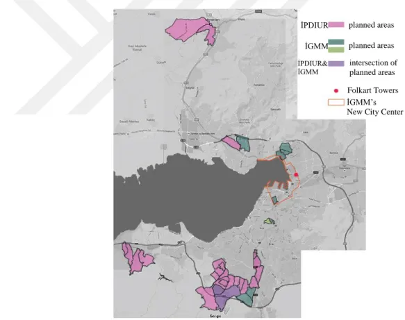
Among several institutions commissioned with urban regeneration projects, there are two main authorities in İzmir to conduct district based regeneration: The Department of Urban Regeneration, associated with İGMM, and İzmir Provincial Directorate of Infrastructure and Urban Regeneration (İzmir Alt Yapı ve Kentsel Dönüşüm İl
Müdürlüğü, henceforth İPDIUR)2
, associated with the Ministry of Urbanization and Environment. Their jurisdictions are based on different constitutional provisions3. These two institutions identified 37 districts in İzmir which are in need of urban regeneration (Figure 10). Ahıhıdır, Kazımpaşa, Seydinasrullah, Cumhuriyet, Osman Aksüner, Aşık Veysel, Seyhan, Ayhan, Cennetçeşme, Yüzbaşı Şerafettin, Özgür, Gazi, Ali Fuat Erden, Limontepe, Bahriye Üçok, Salih Omurtak, Atatürk, 2. İnönü, Narlı and Çatalkaya districts were identified by İPDIUR. Yurdoğlu and Uzundere districts were identified by both institutions. Örnekköy, Cegizhan, Alpaslan, Fuat Edip Baksı, Ballıkuyu, Kadifekale, Emrez and Aktepe districts were identified by İGMM. These districts are located in the old parts of the city, which are inhabited
2
İzmir Provincial Directorate of Infrastructure and Urban Regeneration was founded in 2012, as the provincial branch of the Ministry of Environment and Urbanization.
3
The Department of Urban Regeneration was founded in 2010 within the scope of the 73rd clause of Municipality law 5393. It consists of Urban Regeneration Branch Office, Project Construction Branch Office, and Publicity and Social Transformation Branch Office. In 2011, it was incorporated under The Department of Soil Survey, Earthquake and Disaster Works (İzmir Büyükşehir Belediyesi, 2016).
21
predominantly by low-income groups. Due to budget limitations, only Kadifekale’s regeneration has been completed to date4.
To overcome budgetary limitations, İGMM decided to involve the private sector in the regeneration of the city center. The International Urban Design Ideas Competition for the İzmir Port Area was launched in 2001 as the first step of this process. Since it was an ideas competition, submissions did not have to include detailed plans. The results were evaluated by the planners of İGMM and the concerned district municipalities. Although no action was taken until 2003, the winning project set the tone for Bayraklı’s regeneration, which was announced to be developed as a business quarter by İGMM at that date.
Figure 10 İzmir’s urban regeneration map of 2016 (Google Maps image edited by the author)
4
Kadifekale is a historical district which is located on a hill top, where migrants settled during the 1950s. The area was identified as a landslide zone in 1978 and a ‘disaster prone area’ in the geological reports 1978, 1981, and 2003. However, the renewal process began in 2007 (Mutlu, 2009) due to complex legal processes in addition to budget limitations.
İPDIUR İGMM intersection of planned areas planned areas İGMM’s New City Center Folkart Towers
planned areas
İPDIUR& İGMM
22
In 2003, İGMM prepared a 1/5000 master plan by evaluating the results of the competition. The plan was based on both the winning project and the existing situation of the region (Figure 11) (Erdik and Kaplan, 2009, 54).
Figure 11 İzmir’s New City Center, İGMM’s 1/5000 master plan, 2003 (Erdik and Kaplan, 2009)
According to the final report of the competition, the aim was mainly “to enhance the contemporary image of the city and create a new city center around the port area to support the emerging international status of İzmir” (Arkitera, 2016). The following emphasis of the competition brief, which was repeated in the final report calls for attention: “The urban form suggested by the projects point to the middle of the twenty first century. These physical features correspond to a period when Turkey will be a member of the European Community and a major actor of the Mediterranean region”
23
(Arkitera, 2016). Since the new urban vision could take decades to be realized, competitors were required to take phasing and flexibility into consideration.
German architect Johan Brandi’s proposal received the first prize. The jury report stated that the project could reduce the pressure on the historical city core by offering large public open spaces between high-rise buildings. Brandi saw the archeological site of Bayraklı (old Smyrna) as the starting point for urban development. His plan consists of three zones which would be connected by a rail system: Historical Smyrna (İzmir I) which would include 3-storey residential buildings, today’s İzmir (İzmir II) and a new shoreline (İzmir III) to reduce traffic in the inner parts (Mimarlar Odası İzmir Şubesi: Ege Mimarlık, 2001/4 – 2002/1, 64). His project included a network of pedestrian and bicycle paths, parks, and an Olympic park with sports facilities. The prevailing wind direction was taken into consideration in the placement of the buildings (Figures 12 and 13).
Figure 12 İzmir’s New City Center, within the zones of Johan Brandi’s proposal, 2001 (Mimarlar Odası İzmir Şubesi: Ege Mimarlık, 2001/4 – 2002/1)
24
Figure 13 Johan Brandi’ proposal for New City Center for İzmir, site plan, 2001 (Mimarlar Odası İzmir Şubesi: Ege Mimarlık, 2001/4 – 2002/1)
In the adaptation process of Johan Brandi’s proposal into the development plan, a series of strategic meetings were held with investors, local business associations and professional chambers by İGMM. These groups’ demands were taken into consideration in the land use and density decisions of the plan (Penpecioğlu, 2012, 192). In 2005, İGMM approved the development plan that had been prepared two years ago. The demands of investors encouraged İGMM to revise the plan in 2006 to increase the building density of the New City Center (Yeni Kent Merkezi, henceforth NCC) to attract further investment (Penpecioğlu, 2012, 195).
25
Between 2006 and 2009, a small group of local politicians carried out judiciary actions to nullify the plan due to the lack of geological surveys and reports concerning earthquake risks (Penpecioğlu, 2012, 194) and also lack of social facilities such as green spaces and parking lots (Erdik and Kaplan, 2009, 56). This resulted in the cancellation of the project (Erdik and Kaplan, 2009, 56) which was harshly criticized by the Mayor of Greater Municipality who stated that such judiciary actions harmed the economic development of the city. This hegemonic discourse was also supported by local business associations and investors, who had been planning giant office towers, shopping malls, and gated luxury residents since 2007 (Penpecioğlu, 2012, 194).
The project area, extending from Alsancak Port to the Karşıyaka district, included privately and publicly owned factories, small-scale manufacturing workshops, and warehouses. Until the 2010s, private holdings purchased large parcels in the area with the aim of benefiting from its new status as the city center (Penpecioğlu, 2012, 199; Bayraklı Municipality, 2015).
In 2010, the development plan was approved again by İGMM, following the completion of geological reports and surveys. The related district municipalities, Konak and Bayraklı, finalized the plans at 1/1000 scale (Interview with Sibel Başaloğlu, head of Directorate of Planning (Plan ve Proje Müdürlüğü) in Bayraklı Municipality, 2016). The implementation of the NCC project began in 2011 when private firms started to undertake construction in the area (Penpecioğlu, 2012, 194).
26
3 IN DISCOURSE: CONSTRUCTING AN IMAGE
The NCC project was implemented by private firms and supported by the related municipalities. The aim was to locate İzmir in a competitive position among global cities. This chapter examines the construction of İzmir’s new image in the context of the newly emerging notion of city marketing.
Within this competitive environment Folkart Towers, as the first completed structures in the area, have been presented as İzmir’ new symbol by Folkart Yapı. In the Folkart Towers’ commercials, the images of existing İzmir symbols were used. Following the historical constructions of the latter, the chapter evaluates the representations of the Towers to understand their image creation process in the transforming environment.
3.1 Construction of Urban Images
Structural transformations of urban spaces can occur through catastrophic phenomena. The Great fire of İzmir in 1922 was such an example which erased a considerable portion of İzmir’s history and collective memory. Hence it was a significant mediator in the transformation of the multicultural imperial city to a city of the nation-state (Kolluoğlu Kırlı, 2005, 28; Yüksel, 2013, 19).
In this process, Dangers’ plan (1925) concentrated on rebuilding the city center which was burned down in the great fire. The identity of the new republic was reflected in the plan through the aim to create a modern image. The recent urban form and image of the city center can be traced back to Dangers’ proposal. Aru’s plan (1953), and the first metropolitan plan (1973), too are significant interventions that influenced the city’s formation. These need to be interpreted in the light of dominant political ideologies. For instance, since the protectionist attitude of Dangers’ plan did not meet the municipality’s vision of modernization, Aru’s plan presented a different image which mostly concentrated on socio-economic conditions. The 1973 plan, on the other hand, focused on expanding the city borders and developing the city’s network with other cities due to the domination of economic concerns (Appendix 1). This may be associated with the economic recession of the 1970s that resulted in the economic and spatial restructuring of Western cities (Paddison, 1993, 339) when cities which lost their traditional industries focused on attracting investment. The ensuing
27
competition between cities to attract new investment resulted in the emergence of a new concept, i.e., city marketing (Paddison, 1993, 339).
The term city or place marketing became prevalent in the 1980s particularly in European urban studies. Both there and the US “the practice of city marketing has been linked primarily to local economic development, the promotion of place and encouragement of public-private partnerships to achieve regeneration” (Paddison 1993, 340). However, there are different meanings attached to the term as the Dutch interpretation broadened its scope by including societal welfare into the definition. In its broadest sense, the purposes of city marketing include “raising the competitive position of the city, attracting inward investment, the well-being of its population, and improving its image” (Paddison, 1993, 341).
Urban designers, media-savvy individuals and institutions have a great impact on city imaging, which involves visual narratives. City imaging involves economic strategies to attract new investments that reinforce or reconstruct a city’s image (Vale and Warner, 1998). In economic-geographer Gert-Jan Hosper’s terms, “cities are smart when they explore whether the narrative they want to communicate can be visually symbolized on one spot or a limited number of the spots in the municipality” (2010, 2077). Therefore, water fronts, eye catching locations and attractive buildings are valued as places of investment for their potential symbolic significance (Hospers, 2010, 2077).
İzmir’s NCC project (2001) presents a significant case in this context. İGMM publicized the project as a crucial opportunity to regenerate the old and abandoned industrial area to provide a new urban image to turn İzmir into an international city. İGMM, Konak and Bayraklı District Municipalities, İzmir Branch of the Chamber of Architects, investors, and local finance organizations were the main actors in this process, who emphasized the importance of the area in increasing the competitive and entrepreneurial edge of the city (Penpecioğlu, 2012, 193). The central government, too, supported the project; although it does not have any authority over İzmir’s planning (Penpecioğlu, 2012, 202-204).
The first stage of the NCC project involved the regeneration of Bayraklı as a business quarter. According to the plans that were prepared by İGMM and the district municipalities, private firms were to construct tower blocks in the area. Hence after
28
the approval of the project, the new image of İzmir and Bayraklı in general and Salhane in particular, started to be physically constructed by private firms with the support of national and local authorities. Folkart Towers is one of the pioneer projects in Salhane, which is presented as the new symbol of İzmir in a broad range of representational media.
3.2 İzmir’s Symbols and Folkart Towers
After the great fire, the rebuilding process of İzmir provided new public spaces and reorganized some of the existing ones. During this process, the Clock Tower, Kordon, Cumhuriyet Square, Kültürpark, Varyant, and Asansör can be identified as the most significant sites, which have been identified with the city and have been instrumental in shaping a collective memory. They are frequently represented in such media as films, postcards, and photographs. In 2011 Folkart Yapı used these symbols in the advertisement films of Folkart Towers representing the latter as the new symbol of İzmir, akin to the previous ones. This section examines the historical construction of the city’s symbols and the role of Folkart Towers in this narrative.
3.2.1 Historical Constructions of İzmir’s Symbols
The Clock Tower, Kordon, Cumhuriyet Square, Kültürpark, Varyant and Asansör are İzmir’s renowned public spaces which were identified as the symbols of the city. They were constructed in different time periods, each reflecting the dominant ideology of the period in question. In addition to their political significances, the high degree of public use of these spaces accentuated their meaning in the city’s collective memory.
a) The Clock Tower
The Clock Tower is arguably the most widely used symbol of İzmir. It has been a symbolic element of Konak Square which is surrounded by administrative buildings and is one of the most significant public places of the city (Can, 2007, 122; Ege Mimarlık: Kentsel Tasarım, 2004, 45; Orhon, 2004, 56). Its history dates back to the beginning of the 20th century, when Sultan Abdülhamit II ordered to build several clock towers within the borders of the Ottoman territory to celebrate his 25th anniversary of accession to the throne in 1901 (Can, 2007, 122; Orhon, 2004, 56;
29
Taşkıran, 2010, 4). The towers became symbols of modernization due to their use of the clock, which signified the division of the day according to a 24 hour cycle rather than prayer times (Can, 2007, 122; Taşkıran, 2014, 4-5; Yılmaz, 2003, 16).
Figure 14 Clock Tower, İzmir, 1939 (Can, 2007, 123)
Until 1927, the tower used to bear imperial signs including the Sultan’s signature. Those were removed after 1923, in accordance with the Republican ideology of founding a new nation with no trace of its Islamic past (Taşkıran, 2010, 9; Yılmaz, 2004, 18-19). In the early 1950s, İzmir Municipality planned to redesign Konak Square with the intention of removing all Ottoman traces including the Clock Tower5 (Can, 2007, 126; Kaya, 2002, 130). Although the removal of the tower was not
5
In 1955 a national competition was announced to redesign the square after the request of Ahmet Aru, who was the chief designer of the 1953 İzmir plan and also the planning consultant (şehircilik
danışmanı) of İzmir Municipality (Aşkan, 2011, 6). Doğan Tekeli, Sami Sisa and Tekin Aydın's team
won the competition. However, the proposal was not found applicable by the Municipality. Therefore, a commission was established to study the project, including members from the municipality and Ministry of Reconstruction (Aşkan, 2011, 6; Kaya, 2002, 131). In accordance with the final proposal two monumental public buildings, i.e. the barracks and the prison were demolished in 1955 and 1959 respectively (Can, 2007, 126).
30
implemented, parts of its surfaces which used to bear Ottoman emblems were decorated with Turkish flags6 (Figure 15) (Taşkıran, 2010, 9).
Figure 15 Turkish flags on the Clock Tower, after 1950 (Taşkıran, 2010, 8)
During the second half of the twentieth century, printed media promoted İzmir by means of city guides, published by the İzmir Governship, İzmir Municipality, İzmir Chamber of Commerce, Ministry of Tourism and similar institutions. These have frequently included the Clock Tower in their cover pages (Figure 16). İGMM has used the Clock Tower as its institutional logo since its foundation in 1984 (Figure 17) (Taşkıran, 2011, 4). The popularity of the tower image is exploited by the tourism industry, which is manifested in its manifold use on souvenir items (Figure 18).
6
This was realized in relation to the constitutional provision of 28 June 1927 titled “Removal of Sultans’ Signatures and Eulogies on the Structures which Belong to the State and the Society within the Borders of the Turkish Republic (Türkiye Cumhuriyeti Dahilinde Bulunan Bilumum Mebanii
Resmiye ve Milliye Üzerindeki Tuğra ve Methiyelerin Kaldırılması Hakkındaki Kanun) (Milliyetçi
31
Figure 16 Front page, İzmir City Guide, 1981 (Nadir Kitap, 2016)
Figure 17 İGMM’s current logo (İzmir Büyükşehir Belediyesi, 2016)
Figure 18 The image of the Clock Tower imprinted on sand; a clock with the image of the Clock Tower; a cologne bottle in the form of the Clock Tower (Sınırsızal.com, 2016; Evmanya, 2016;
32
Although several planning interventions changed Konak Square in the second half of the 20th century, the status of the tower remained unchanged7. In 2007, a questionnaire titled ‘Research of Political Tendencies and Symbols of İzmir’ conducted by İzmir Chamber of Commerce revealed that the Clock Tower at Konak Square was the most popular symbol associated with İzmir (NTVMSNBC, 2007; Taşkıran, 2011, 3).
The pedestrianization of the square in 2004 strengthened the symbolic value of the tower by rendering it as a gathering place8.Today the area that surrounds the tower is used by the city’s residents and tourists alike to rest and socialize. It is also a popular spot for picture taking (Figure 19).
Figure 19 Clock Tower (Wowturkey, 2004)
7
In the 1970s filling operations were made in Konak which have shaped today’s fabric (Can, 2007, 126). In the 1980s within the scope of Kemeraltı Preservation Plan (Kemeraltı Koruma Planı), multi-story buildings were constructed along the shoreline which blocked the interaction between the sea and the historic fabric (Ege Mimarlık: Kentsel Tasarım, 2004, 47).
8
In the beginning of the 2000s, the square was re-planned with the contributions of İzmir Chamber of Architects. The project connects Kemeraltı Bazaar to the Konak ferry station, and includes the old Konak Square in its physical center (Ege Mimarlık: Kentsel Tasarım, 2004, 47-48).
33
b) Kordon
Kordon, the waterfront strip between Alsancak customs area and Konak Square (Yılmaz, 2004, 98), is one of the most significant places of İzmir in terms of forming the morphology of the waterfront and shaping urban life (Yüksel, 2013, 50-51). In the 19th c., bars, cafes, theaters, clubs and cabarets in the area reflected the European life style of the non-Muslim residents living in the area9 (Kayın, 2006, 18; Kolluoğlu Kırlı, 2005, 25). Although the 1922 fire interrupted the urban activity of Kordon, the publicity of the waterfront continued after the rebuilding process10 (Kayın, 2006, 19).
For example, research on Turkish films shot between 1960 and 1975 shows that those which featured İzmir mostly included Kordon scenes. The distinctive pavement along Kordon, phaetons11 and the sea view were strong visual elements that attracted attention (Ülkeryıldız and Önder, 2013, 31). These elements are still used in contemporary İzmir representations by artists, individuals and institutions that promote the city (Figures 20, 21 and 22).
9
In the 19th century, Kordon was constructed by landfill and has been the most popular recreation area in the city center (Kayın, 2006, 18).
10
Between the 1930s and 1950s, following Dangers’ plan, 3-4 storied modern apartments were built from Gündoğdu to Cumhuriyet Square (Figure 20) (Yüksel, 2013, 58). When the rural migration wave of the 1950s caused a housing shortage, Aru’s plan suggested increasing the density of residential areas proposing the allowance of 7-8 stories for the waterfront. Although building heights were increased at the waterfront, entertainment activities remained at the street level. In the 1990s, the area between Alsancak port and Cumhuriyet Square was filled again to extend the seashore as a green urban space which transformed the physical and historical characteristics of Kordon (Kayın, 2006, 20).
11
After the landfill operation in the 19th century, foreign merchants began to move to İzmir which mobilized the use of phaetons to enable transportation from the shoreline to the inner areas. They were associated with the West and modernity, and became the symbol of Kordon and İzmir (Özgönül, 2007).
34
Figure 20 Screenshot, Uyanık Kardeşler, 14:57sec (Saner, 1974)
Figure 21 Kordon, İzmir Guide, 2007 (İzmir Ticaret Odası, 7)
35
c) Cumhuriyet Square
After the foundation of the Turkish Republic Cumhuriyet Square became one of the symbolic areas associated with the nationalist ideals of the new state. In Dangers’ plan (1925) it was the most prominent entry point for those who approached the city from the bay (Figure 23) (Yüksel, 2013, 68-69). With the Gazi Statue situated at its center, the square became the site for the celebration of republican anniversaries (Can, 2007, 130; Çelebi, 2002, 97-101). Hosting such events as the placement of a wreath at the skirts of the Gazi Statue, folk-dance shows, and poetry recitals during celebrations, Cumhuriyet Square is still associated with the Republican ideals of national pride.
Figure 23 Cumhuriyet Square (Wowturkey, 2006)
d) Kültürpark
From its founding years, Kültürpark was the symbol of not only İzmir but also the country at large, because it represented the international recognition of the growing economy of the new republic (Yı1maz, Kılınç, Pasin, 2015, 42 & 166). It was founded in 1936, with the primary aim of accommodating an annual international exposition organized by the İzmir Chamber of Commerce12. It was designed as a vast
12
In 1923 the first Turkish Economic Congress was held in İzmir. Within the scope of the congress, a national exposition was organized to exhibit agricultural and industrial Turkish products (Aksoy and Yurdakul Özgünel, 2001, 13; Karpat, 2009, 75; Yı1maz, Kılınç, Pasin, 2015, 75-77). This can be accepted as the first step of the Kültüpark’s establishment. After the foundation of the İzmir