IC
ON
A
RP
ICONARP International Journal of Architecture & Planning Received 13 March 2017; Accepted 06 June 2017 Volume 5, Issue 1, pp: 134-150/Published 30 June 2017 DOI: 10.15320/ICONARP.2017.18–E-ISSN: 2147-9380
Abstract
Human’s weakened bond to residential areas, compromised identity and stability of residents in residential areas, have resulted in higher rate of transfer. Individual and collective understanding of the environment could be seen as a major force in shaping that environment through the action of human choices and behavior. In this regard, Cognitive maps are of great theoretical and practical importance for understanding how humans interact with their environment.
This research is aimed to investigate the effects of the individual factors on the formation of cognitive maps in the neighborhood. Research seeks to answer the question: "How and to what extent the individual factors affect the cognitive and metal maps of the residents in the neighborhood?" Research is a combination of qualitative (interview)
The Effects of Individual
Factors on the Formation
of Cognitive Maps
Zahra Alinam*
Keywords: Cognitive map, individual factors,
neighborhood, Tabriz.
*Ph.D. Student in Islamic Urbanism, Architecture and Urbanism Faculty, Tabriz Islamic Art University, Tabriz, Iran. E-mail: [email protected]
ICO N ARP. 20 17. 18 – E -I SSN : 21 47 -9380
and quantitative (questionnaire) methods which is conducted on 297 residents of a neighborhood in the city of Tabriz.
Results indicate that individual characteristics such as gender, age, occupational status, housing ownership status, length of residence, transport mode and duration of walking have a significant relationship within the formation of three components of cognitive map (landmark, route-road and survey knowledge). Educational status is the only variable that does not interact significantly with the cognition knowledge of the neighborhood. Achievement of this research is to introduce the effective individual factors in the formation of cognitive and mental image within the neighborhood and effectiveness rate of each in this process.
INTRODUCTION
Human’s weakened bond to residential areas, compromised identity and stability of residents in residential areas, have resulted in higher rate of transfer. Nowadays, the texture of neighborhoods has lost its relation with in the perception of the resident living in it and has confronted him with a serious crisis of identity.
Residents' perceptions of a desired place and its elements are directly related to their physical and mental needs. Hence, extracting components involved in the formation of mental image and applying them in future designs is a prerequisite for fulfillment of needs through the place.
Due to the cultural and historical diversity in various parts of the city, each element has its true meaning in interaction with the surrounding elements set. Thus, to perceive the phenomena and their interactions with the surrounding environment, In addition to observing them as an outside observer, they should be perceived through the eyes of the people who are the subject or object of those phenomena. It should be the main starting point for any analysis of the relationship between humans and the environment. Taking this inside view into account could make an important contribution to the planning process, helping to adjust it to human needs.
Cognitive maps are of great theoretical and practical importance for understanding how humans interact with their environment. They contain subjective knowledge of the environment, and can give us an insight into people’s orientation in the environment and how it is used. In this regard, identification of individual factors affecting cognitive maps formation can provide valuable information to recognize the view from ‘‘the inside,’’ which should complement the view from the outside.
- V olu m e 5, Is su e 1 / Pu bli shed : Jun e 20 17
This research is aimed to investigate the effects of the individual factors on the formation of cognitive maps in the neighborhood. Research seeks to answer the question: "How and to what extent the individual factors affect the cognitive and metal maps of the residents from the neighborhood?"
The structure of the research is divided into conceptual and evidential approaches. In the conceptual section, the background of the subject is reviewed in the field of cognitive map and individual factors affecting its formation. Within the evidential section, to evaluate the effects of individual factors on the formation of cognitive maps, a specific neighborhood in Tabriz (The Gharebaghis' neighborhood) with purposeful sampling is chosen as the research case study.
RESEARCH METHOD
To eliminate local factors and minimize socio-cultural variables affecting the cognitive mapping process, only one place (the neighborhood of Gharebaghis) with purposeful sampling was chosen as the research case study. Thus it was possible to assess individual factors of the residents and focus on the types of knowledge forming cognitive maps.
Research is a combination of qualitative (interview) and quantitative (questionnaire). In order to determine the appropriate number of participants, first a pretest was performed as a pilot study on 40 residents of the neighborhood and after the estimation of variance for the initial sample (S2) at the confidence level of 95%, the number of the sample was increased to 2971. To
increase the reliability of results and to dispel ambiguities for participants, the test was conducted on 297 residents of the neighborhood in the form of questionnaires (including residents' statistical information and their sketch maps of the neighborhood) and individual semi-structured interviews (conducted in person by the author to provide clues about the analysis of statistical results).
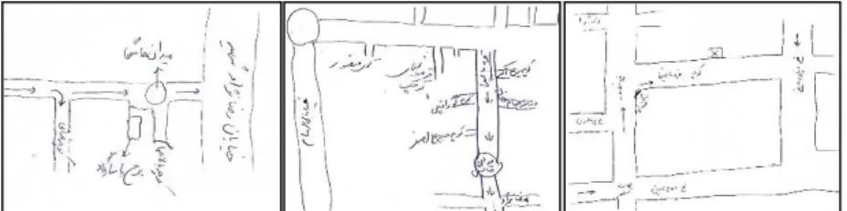
Statistical data of questionnaires were analyzed by SPSS Ver15. The sketch maps drawn by residents (Figure 1) were assessed based on the five-level Likert scale ranging from “Very poor” on one end to “Very good” on the other with “Acceptable” in the middle (5≥M≥0) in three categories of landmark knowledge, route-road knowledge and survey knowledge, and the relationship between these components and individual factors (gender, age, occupational status, educational status, housing ownership status, length of residence, transport mode and duration of walking) were examined with the help of analysis of
1.
136
ICO N ARP. 20 17. 18 – E -I SSN : 21 47 -9380
variance (ANOVA) and Mann-Whitney tests. Finally, the quantitative results obtained from the software analysis were qualitatively interpreted based on the data from semi-structured interviews and in accordance with the finding of previous studies.
COGNITIVE AND MENTAL MAP
The notion of a “cognitive map”, is attributed to Tolman (1948) who demonstrated that rats freely exploring an environment (maze), tend to construct an internal “map” of it, which they later employ to execute spatial tasks. In a subsequent paper entitled “Cognitive Maps of Rats and Men” he extended his theory to the human domain. Since then the concept has been employed extensively by cognitive scientists (psychologists, neurologists and the like) and also by students of culture and society mainly as a reference to images of space or as a metaphor for space. This is why there are many interpretations and different ways of using concepts of mental cognition and mental maps in academic research (Fenster, 2009).
Cognitive mapping is defined as "a process composed of a series of
psychological transformations by which an individual acquires, stores, recalls, and decodes information about the relative locations and attributes of the phenomena in his everyday spatial environment" (Downs and Stea, 1973). Cognitive mapping is usually considered to be a subset of spatial cognition which can be defined as "the knowledge and internal or cognitive representation of the structure, entities and relations of space; in other words, the internalized reflection and reconstruction of space and thought" (Hart and Moore, 1973). In turn, spatial cognition is sometimes seen as a subset of environmental
cognition, which refers to "the awareness, impressions,
information, images, and beliefs that people have about environments. It implies not only that individuals and groups have information and images about the existence of these environments and of their constituent elements, but also that they have impressions about their character, function, dynamics, and structural interrelatedness, and that they imbue them with meanings, significance, and mythical-symbolic properties" (Moore and Golledge, 1976).
Figure 1. The samples of the residents' cognitive maps (Alinam, 2014)
- V olu m e 5, Is su e 1 / Pu bli shed : Jun e 20 17
The end product of a cognitive mapping process is called a
cognitive map. Usually accepted to be a device that helps to
simplify and order the complexities of human-environment interactions (Walmsley, Saarinen and MacCabe, 1990), the cognitive map is essentially our individual model of the world in which we live. Kitchen and Blades (2002) defined cognitive map as a term, which refers to “individual knowledge of spatial and environmental relations, and the cognitive processes associated with the encoding and retrieval of the information from which it is composed” (Kitchen and Blades, 2002). Cognitive maps are internal representations of our physical environment, particularly centering on spatial relationships. Cognitive maps seem to offer internal representations that simulate particular spatial features of our external environment (Rumelhart and Norman, 1988; Wagner, 2006).
Methods developed to recover cognitive configurations are as varied as the purposes behind such research. One of the earliest methods suggested by Lynch (1960) was the use of sketch map techniques. Sketch mapping has long appeared to be a useful instrument for recovering information about environments, if the maps are properly interpreted.
Humans seem to use three types of knowledge when forming and using cognitive maps which is visible in the sketch maps:
Landmark knowledge is information about particular features at a
location and which may be based on both imaginal and propositional representations (Thorndyke, 1981). Route-road
knowledge involves specific pathways for moving from one
location to another. It may be based on both procedural knowledge and declarative knowledge. Survey knowledge involves estimated distances between landmarks, much as they might appear on survey maps (Thorndyke, and Hayes-Roth, 1982). It may be represented imaginally or propositionally (e.g., in numerically specified distances).
Thus, people use both an analogical code and a propositional code for imaginal representations such as images of maps (McNamara, Hardy, and Hirtle, 1989; Russell and Ward, 1982).
INDIVIDUAL FACTORS AFFECTING THE STUDY OF COGNITIVE MAPS
Each individual builds up his own personal image which, because of his temperament and background, will differ from that of any other individual. Many researches have emphasized a variety of variables which appear to relate to individual and group difference in the perception and evaluation of the townscape
ICO N ARP. 20 17. 18 – E -I SSN : 21 47 -9380
(Table 1). However the importance of the physical environment in map formation suggests that a public image exists, consisting of the overlap of individual cognitive images.
Klein's (1967) work on respondents of widely differing backgrounds, discovered gender, socioeconomic status, and place of residence to be important variables effecting the way people viewed the city. Physiological differences and distinctive culturally assigned roles suggest that sex is important in terms of spatial imagery (Erikson, 1964). A study of Los Angeles demonstrated that mental map size, content, and directional bias differed according to gender (Everitt and Cadwallader, 1972). Psychoanalysts assert that, when creating environments, girls design static enclosures, whereas boys are concerned with the externalities of buildings, with activity in unenclosed space, and with movements along paths (Erikson, 1964). In Venezuela Appleyard (1970) found that females tended to draw area-based than path-based (sequential) maps, and were more prone to error.
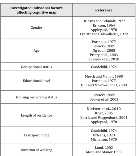
Table 1. Studies on the individual factors affecting cognitive map
(Alinam, 2014)
Reference Investigated individual factors
affecting cognitive map
Orleans and Schmidt, 1972 Erikson, 1964 Appleyard, 1970 Everitt and Cadwallader, 1972 Gender Porteous, 1977 Lewicka, 2009 Ng et al., 2005 Pretty et al., 2003 Lovejoy et al., 2010 Age Goodchild, 1974 Occupational status
Mesch and Manor, 1998 Porteous, 1977 Hur and Morrow Jones, 2008 Educational level
Lewicka, 2009 Brown et al., 2003 Housing ownership status
Nielsen et al., 2010 Knez, 2005 Borrie and Roggenbuck, 2001
Appleyard, 1970 Length of residence Goodchild, 1974 Orleans, 1973 Michelson, 1970 Transport mode Lund, 2002 Mesh and Manor,1998 Duration of walking
The imageability of individual structures may vary with age. A study in England found that whereas elderly persons' mental maps contained afterimages of structures actually derelict or
- V olu m e 5, Is su e 1 / Pu bli shed : Jun e 20 17
demolished, the cognitive maps of young persons tended to be dominated by new, highly visible construction project (Porteous, 1977).
Experience as a function of length of residence affects the cognitive maps of the residents. Recent immigrants are likely to have images different from those of long-term residents. In a new city in Venezuela, newcomers tended to produce sequential (path- oriented) maps rather than maps which emphasized spaces. Their maps were also more restricted in area, but were less prone to error than those of longer-term inhabitants, indicating a higher level of interest (Appleyard, 1970). On the basis of experience, metal maps should be most detailed in areas most frequently used, notably around the home. This is especially so for females and for children (Anderson and Tindall, 1972).
Several studies have found differences in imagery on a socioeconomic class basis (Ladd, 1970; Orleans, 1973; Stea, 1974). Appleyard (1970) found several components of class to be significant variables. Automobile travelers produced more coherent, broadly based maps, whereas 80 percent of the bus riders' maps were fragmented, inaccurate, and indicative of repeated sequential journeys. Bus riders tended to be of low education, thus emphasizing the importance of transport mode in imagery formation. The most accurate maps were those of business executives and skilled workers (self-employed), the least accurate those of housewives and professionals. Moreover educated residents had a different view than the less educated. Maps of the less educated were most clearly based on subjective experience and tended to describe their own journeys rather than the existing transportation system. The more educated groups drew the city more objectively and coherently. Their ability to visualize coherent patterns, however, could lead to error through inferring the existence of an absent element because of previous experience with similar layouts (Porteous, 1977).
Using a single measure of social class, namely, occupational status, Goodchild (1974) found that middle-class maps tended to cover a wider area and incorporate a more widespread road network than did working-class maps. It was concluded that middle-class people tend to conceptualize the environment in a clearer and more coherent manner than working-class persons2. Ineichen
(1972) suggested the housing ownership status as another measure of socio-economic class. He argued that the fact of home ownership alone makes people more aware of the public environment surrounding their home base.
2. The "working class" includes individuals, groups, and families who can be broadly characterized as having none or some college education and living in rented homes. Members of the working class are usually employed in manual, unskilled, or semi-skilled jobs at workplaces where they have little or no control.
The "middle-class" is comprised of people who normally have a college education and are involved in professional work. They are usually owners of a home and can move up the ladder to afford a nicer and more comfortable house.
ICO N ARP. 20 17. 18 – E -I SSN : 21 47 -9380 CASE STUDY
Tabriz, the capital of East Azerbaijan province is among Iran's six main historical and cultural cities. As old and weary parts of a city, central parts of the city are constantly under renovation and transformation and this increases the level of attenuation of the residents' bond with the residential areas of these regions. Over the last ten years, the Gharebaghis’ neighborhood, as one of the central neighborhoods located in Region 8 of Tabriz, has been going through constant renovations. The adjacency of historical texture with the new one and integration of them during the renovation provides the possibility to study and investigate the effects of both these textures in the form of a case study (Figure 2). The Gharebaghis’ neighborhood is among the rare neighborhoods in Tabriz which has always maintained its genuineness and it seems that the old residents have kept their attachment to the neighborhood in spite of renovations and transformations in texture. The study of cognitive maps of residents in a neighborhood with such properties can provide us with valuable information.
RESULTS AND DISCUSSION
In line with the research aim, the impact of each individual factor on the components of cognitive map is reported in graph form based on the results of data analysis, on average of (5≥M≥0)3:
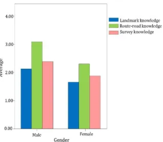
Gender: Figure (3) shows that men have stronger cognitive knowledge than women. This confirm the findings of studies which claim that environmental images of women are different from those of men (Orleans and Schmidt, 1972)
There appears to be strong congruence between an individual's cognitive map and his/her regular activity pattern. Gender difference in mental maps may be the result of differing activity patterns. Household division of labor is still largely defined by gender roles, and many wives remain tied to the home base,
Figure 2. Images of Gharebaghis'
neighborhood(Alinam, 2014)
3. For a significance relationship Sig. must be less than 0.05 (Sig. <0.05)
- V olu m e 5, Is su e 1 / Pu bli shed : Jun e 20 17
especially if young children are present in the home. In other words, these differences are due to different social roles rather than biological differences (Porteous, 1977). Due to the lower mobility among women compared to men, the cognitive maps of women were limited to certain places in the neighborhood, to and from which they commuted. Therefore, women had cognitive maps with a lower width but greater details compared to men.
Age: In examining the effect of age factor on cognitive maps of the residents from the neighborhood, three age groups: A) 18-40, B) 41-60, C) over 60 were considered for average test respectively as the young, middle-age and elderly age groups. Route-road and landmark knowledge, respectively, have the highest and the lowest averages between age groups. The (60-41) age group has the highest average compared to the other groups (Figure 4). Recent renovations, way widening, and destruction of many historical and symbolic buildings in the neighborhood have led to a mismatch between the current appearances of the neighborhood with the present mental images of residents. This is more evident in residents over 40 years of age, who are mostly the old residents of that neighborhood. Moreover, destruction of historical and symbolic buildings by weakening the landmark knowledge have resulted in enhanced route-road knowledge in mental images of residents particularly the young generation with a shorter duration of residence in the neighborhood. This could be in accordance with the research results by Porteous (1977), where the elderly often show the images of dilapidated buildings in their mental images, while in the minds of younger ones, the images of under construction projects are more prevalent. Accordingly, the cognitive maps presented by this group will be different with the current situation of the neighborhoods.
Figure 3.The relationship between gender and cognitive components (Alinam, 2014)
ICO N ARP. 20 17. 18 – E -I SSN : 21 47 -9380
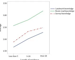
Length of residence: Length of residence factor in the neighborhood were evaluated among three groups with a) less than 5, b) 5-20, c) over 20 year of residence. There is a significance relation between the length of residence in the neighborhood and cognition components so that as residence length increases in the neighborhood, the cognitive knowledge promotes (Figure 5). This finding is in line with the research by Borrie and Roggenbuck (2001) who suggest that prolonged positive interaction with the environment contributes to enhanced cognition in individuals. Similarly, this confirms the findings by Nielsen et al (2010), Knez, (2005), and Erkip (2010) regarding the importance of time as a positive factor in cognition of a place.
Stability not only increases the cognition to a residential neighborhood but also helps with the development of social ties. Social bonds facilitate local residents' efforts to monitor outside situations and public spaces in the neighborhood. Social contacts allows residents to become familiar with each other. Repeated interactions increase social trust and sense of security among residents and neighbors which leads to the attachment to the neighborhood.
Figure 4.The relationship between
age and cognitive components (Alinam, 2014)
Figure 5. The relationship between length of residence and cognitive components (Alinam, 2014)
- V olu m e 5, Is su e 1 / Pu bli shed : Jun e 20 17
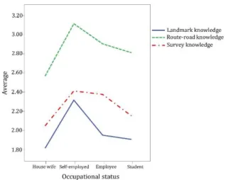
Occupational status:Resident's occupational status factor was evaluated in four groups: a) housewives, b) self-employed, c) employees and d) students. Figure (6) shows that self-employed group has the highest and the house wives group has to lowest cognitive knowledge. While the Route-road knowledge have the highest average for both. There isn’t any significant relation between the occupational status factor and the survey knowledge component(Sig. = 0.059).
It is interpreted that self-employed group as middle-class residents have a greater emotional investment in the environment. They tended to attach somewhat greater significance investment to townscape features of high architectural quality or historic interest, and were more concerned with aesthetic improvement than were employees. Moreover, this group usually live close to their workplace and easily can commute between their home and workplace.Students group often because of being non-native doesn't establish significant social relations in the neighborhood and spend most of their time outside of the neighborhood to meet their needs.
Educational level: There is no significant relation between the educational level factor and each of three components of cognitive map: Landmark knowledge (Sig. = 0.487), Route-road knowledge (Sig. = 0.199), Survey knowledge (Sig. = 0.390).
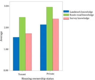
Housing ownership status: Figure (7) shows that cognitive knowledge is higher in the group with private housing ownership compared with group of tenants in the neighborhood.Route-road and landmark knowledge, respectively, have the highest and the lowest averages between both groups of residents.
It seems that the ownership of private housing in the neighborhood is directly related to the length of residence in the neighborhood and promotes the residents cognition toward it.
Figure 6.The relationship between
occupational status and cognitive components (Alinam, 2014)
144
ICO N ARP. 20 17. 18 – E -I SSN : 21 47 -9380
This finding may confirm the fact that poor people tend to have far more constricted images than affluent people attributed to the costs of spatial mobility (Orleans, 1973; Michelson, 1970).
Transport mode: Residents' transport mode in the neighborhood was evaluated by four categories: a) on foot, b) bicycle, c) taxi and d) private car. Survey and landmark knowledge has the highest average among private car users and the lowest average among motor/bicycle users in the neighborhood (Figure 8). There isn’t any significant relation between the transport mode factor and the route-road knowledge component (Sig. = 0.146).
This finding is in line with the research by Goodchild (1974) who suggests that people with private cars have a more accurate idea of their environment than those who rely on public transportation. Route-road knowledge is more effective than landmark knowledge in the formation of cognitive maps and has the highest average among group with private car. As a result, the cognition rate is higher in residents with cars.
Figure 7.The relationship between
housing ownership status and
cognitive components (Alinam,
2014)
Figure 8. The relationship between transport mode and cognitive components (Alinam, 2014)
- V olu m e 5, Is su e 1 / Pu bli shed : Jun e 20 17
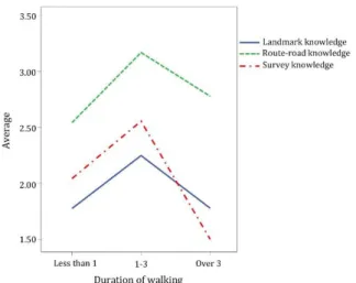
Duration of walking: To evaluate the effect of walking duration factor on cognitive knowledge of residents, the daily duration of walking in the neighborhood was categorized into three groups of a) less than 1, b) 1-3 and c) over 3 hours. Cognitive map knowledge has the highest average among the group with (1-3) hours of walking duration in the neighborhood. For the group with over 3 hours walking duration, the survey knowledge has the highest average and for the group with less than 1 hour walking duration, landmark knowledge has the lowest average (Figure 9). This finding confirms the research by Mesh and Manor (1998) who suggest that the higher characteristics of the physical and social environment are considered; the more cognition is formed toward the neighborhood. By increasing the duration of walking in the neighborhood, the opportunity to examine physical and social environments goes up and this leads to the promotion of cognition knowledge about the neighborhood. According to the reciprocal relationship between activity and cognition, presence and participation in social events in the neighborhood increase the average of cognitive knowledge of the residents.
CONCLUSIONS
Results indicate that individual characteristics such as gender, age, occupational status, housing ownership status, length of residence, transport mode and duration of walking have a significant relationship within the formation of three components of cognitive map (landmark knowledge, route-road knowledge and survey knowledge). Education is the only variable that does not interact significantly with the cognition knowledge of the neighborhood.
Figure 9.The relationship between
duration of walking and cognitive components(Alinam, 2014)
ICO N ARP. 20 17. 18 – E -I SSN : 21 47 -9380
Today, the use of cities and urban spaces by citizens does not match the designed structure of the cities and this is why the citizen's satisfaction of the physical structure of the city is declining. Urban design is regarded as one of the professions influencing the living environment and human activities. In the design of a city and urban space, the relationship between human and environment and the way this relationship is established is of significance. Humans, environment and the relationship between them should simultaneously be considered in urban design. Urban designers require psychological understanding of the cognitive processes of the human mind in the creation of urban spaces. Through the investigation of the relationship between these processes and the physical environment, it is possible to achieve maximum spatial adaptation in urban spaces and provide residents with psychological and cognitive needs in a city.
Acknowledgement
This article is extracted from a master’s thesis by the author entitled "Place attachment in neighborhood: A cognitive psychological approach", written under the supervision of Prof. Dr. Mohammad Taghi Pirbabaei and Prof. Dr. Minou Gharehbaglou and completed in September 2014 at the Tabriz Islamic Art University, Tabriz, Iran.
REFERENCES
Alinam, Z. (2014). Place attachment in neighborhood: A cognitive
psychology approach (Master’s thesis), Tabriz Islamic Art
University, Tabriz, Iran.
Anderson, J. and Tindal, M. (1972). The concept of home range: new data for the study of territorial behavior.
Environmental Design: Research and Practice (Proceedings
of EDRA 3), Los Angeles, 1-7.
Appleyard, D. (1970). Styles and methods of structuring a city.
Environment and Behavior, 2(1), 100-117.
Borrie, W. T. and Roggenbuck, J. W. (2001). The dynamic, emergent, and multi-phasic nature of on-site wilderness experiences. Journal of Leisure Research, 33(2), 202–28. Brown, B., Perkins, D. D. and Brown, G. (2003). Place attachment
in a revitalizing neighborhood: individual and block levels of analysis. Journal of Environmental Psychology, 23(3), 259–271.
Downs, R. M. and Stea, D. (1973). Image and Environment. Chicago: Adline.
Erikson, E. H. (1964). Insight and responsibility. New York: WW Norton.
Erkip, F. (2010). Community and neighborhood relations in Ankara: An urban–suburban contrast. Cities, 27(2), 96-102.
- V olu m e 5, Is su e 1 / Pu bli shed : Jun e 20 17
Everitt, J. and Cadwallader, M. (1972). The home area concept in urban analysis: The use of cognitive mapping and computer procedures as methodological tools. Environmental Design:
Research and Practice (Proceedings of EDRA 3), Los Angeles,
1-10.
Fenster, T. (2009). Cognitive temporal mapping: the three steps method in urban planning, Planning Theory and Practice, 10(4), 479–498.
Goodchild, B. (1974). Class differences in environmental perception; an exploratory study. Journal of Urban Studies, 11(2), 157-169.
Hart, R. A. and Moore, G. (1973). The Development of Spatial Cognition, In R. M. Downs and D. Stea (Eds.), Image and
Environment. Chicago: Aldine Publishing Company,
246-288.
Hur, M. and Morrow-Jones, H. (2008). Factors that influence resident’s satisfaction with neighborhoods. Environment
and Behavior, 40(5), 619-635.
Ineichen, B. (1972). Home ownership and manual workers' life style. The Sociological Review, 20(3), 391-412.
Kitchen, R. and Blades, M. (2002). The Cognition of Geographic
Space. London: IB Tauris.
Klein, H.J. (1967). The delimitation of the town center in the image of its citizens, In E.J. Brill (Ed.), Urban Core and Inner City, Leiden: University of Leiden, 286-345.
Knez, I. (2005). Attachment and identity as related to a place and its perceived climate. Journal of Environmental Psychology, 25(2), 207–218.
Ladd, F. (1970). Black youths view their environment: neighborhood maps. Environment and Behavior, 2(1), 74-99.
Lewicka, M. (2009). What makes neighborhood different from home and city? Effects of place scale on place attachment,
Journal of Environmental Psychology, 30(1), 35–51.
Lovejoy, K.; Handy, S. and Mokhtarian, P. (2010). Neighborhood satisfaction in suburban versus traditional environments: An evaluation of contributing characteristics in eight California neighborhoods, Landscape and Urban Planning, 97(1), 37-48.
Lund, H. (2002). Pedestrian environments and sense of community. Journal of Planning Education and Research, 21(3), 301-312.
Lynch, K. (1960). The image of the city. Cambridge. Mass: M. I. T. Press.
McNamara, T. P., Hardy, J. K., and Hirtle, S. C. (1989). Subjective hierarchies in spatial memory, Memory and Cognition, 17(4), 444–453.
ICO N ARP. 20 17. 18 – E -I SSN : 21 47 -9380
Mesch, G.S. and Manor, O. (1998). Social ties, environmental perception, and local attachment. Environment and
Behavior, 30(4), 504-519.
Michelson, W. H. (1970). Man and His Urban Environment: A
Sociological Approach, Reading, MA: Addisson-Wesley.
Moore, G. T., and Golledge, R. G. (1976). Environmental knowing:
Theories, research, and methods. Stroudsburg, Pa.: Dowden,
Hutchinson and Ross.
Ng, S. H., Kam, P. K., and Pong, R. W. (2005). People living in ageing buildings: Their quality of life and sense of belonging.
Journal of environmental psychology, 25(3), 347-360.
Nielsen-Pincus, M.; Hall, T.; Force, J. E. and Wulfhorst, J. D. (2010), Socio demographic effects on place bonding. Journal of
Environmental Psychology, 30(4), 443-453.
Orleans, P. (1973). Differential cognition of urban residents: effects of social scale on mapping, In R. M. Downs and D. Stea (Eds.), Image and Environment. Chicago: Aldine Publishing, 115-130.
Orleans, P. and Schmidt, S. (1972). Mapping the City: Environmental Cognition of Urban Residents, In W. Mitchell, (Ed.), Edra 3. Los Angeles: University of California Press. Porteous, J. D. (1977). Environment and Behavior: planning and
everyday urban life, Reading, MA: Addison-Wesley.
Pretty, G. H., Chipuer, H. M., and Bramston, P. (2003). Sense of place amongst adolescents and adults in two rural Australian towns: The discriminating features of place attachment, sense of community and place dependence in relation to place identity. Journal of Environmental
Psychology, 23(3), 273-287.
Rumelhart, D. E. and Norman D. (1988). Representation in memory, In R. C. Atkinson; R. J. Herrnstein; G. Lindzey and R. D. Luce (Eds.). Stevens' handbook of experimental
psychology, Vol. 2, New York: Wiley, 511-587.
Russell, J. A. and Ward, L. M. (1982). Environmental psychology.
Annual Review of Psychology, 33(1), 651-688
Stea, D. (1974). Architecture in the head: Cognitive Mapping, In J. Lang; C. Burnette; W. Moleski and D. Vachon (Ed.), Designing
for Human Behavior: Architecture and the Behavioral Sciences. Stroudsburg, PA: Dowden, Hutchinson and Ross
Inc., 157-168
Thorndyke, P. W. (1981). Distance estimation from cognitive maps. Cognitive Psychology, 13(4), 526–550.
Thorndyke, P. W., and Hayes-Roth, B. (1982). Differences in spatial knowledge acquired from maps and navigation. Cognitive
Psychology, 14(4), 580–589.
Tolman, E. C. (1948). Cognitive maps in rats and men.
Psychological review, 55(4), 189.
- V olu m e 5, Is su e 1 / Pu bli shed : Jun e 20 17
Wagner, M. (2006). The geometries of visual space. Mahwah, NH: Erlbaum.
Wahnsley, D. J., Saarinen, T. F. and MacCabe, C. L. (1990). Down under or center stage? The world images of Australian students. Australian Geographer, 21(2), 164-173.
Resume
Zahra Alinam, is a Ph.D. student in Islamic urbanism at Tabriz Islamic Art University, Iran. She is a member of Iran's National Elites Foundation since 2013. She has participated in several major governmental projects as an architect and urban designer. She is also a lecturer in the undergraduate and graduate levels at several universities of Iran and has different articles and researches on key issues of urban design with a cognitive psychological approach. Her Master thesis entitled "Place Attachment in Neighborhood: A Cognitive Psychological Approach", was a research-based project discussing an interdisciplinary topic between the fields of Urban Design and Psychology. She was granted with Exceptional Talented Student Advantage to enter Ph.D. program in Islamic Urbanism in 2015 and continues to research the urban concepts in the field of cognitive psychology and neuroscience for her doctoral thesis.