A Countryside in Transition: The Galinoporni-Kaleburnu Plain (Cyprus)
in the Passage from Late Antiquity to the Early Middle Ages
(ca. 600 – ca. 850)
Měnící se krajina: planina Galinoporni-Kaleburnu (SV Kypr)
na přechodu mezi pozdní antikou a raným středověkem
(ca 600 – ca 850)
Luca Zavagno — Bülent Kızılduman
Předloženo redakci v září 2016, upravená verze v dubnu 2018
This paper aims to both tip the chronologically-unbalanced rural surveys conducted on the island of Cyprus in the last decades (as focusing almost exclusively on the Roman and Late Antique period) and re-assess the traditional historiographical interpretation of the fate of local rural settlements and population in the passage from Late Antiquity to the early Middle Ages (i.e. between the late sixth to the early ninth century). Indeed, we cannot simply take for granted that at the time under scrutiny Cyprus was overwhelmed by Arab incursions turning the island into a no man’s land, severing commercial and shipping routes, bringing to an end any economic, social and cultural form of life in the countryside, causing massive depopulation and abandonment of prosperous rural villages along the coasts in favor of hastily built and fortified (often seasonal) hilltop settlements.
In the light of the latter remark, the authors will use the preliminary results of a recent extensive rural survey conducted in the plain of Galinoporni/Kaleburnu on the Karpas peninsula to propose a picture of the Cypriot landscape as characterized by the early medieval resilience of the varied range of rural settlements (farms, hamlets and villages) dating back to previous centuries and by the lack of any catastrophic occupational gaps after the mid-seventh century.
Cyprus, Mediterranean, Rural, Archaeology, Byzantium, Late Antiquity, Middle Ages
Cílem tohoto článku je jak doplnit chronologicky nevyvážené průzkumy uskutečněné ve venkovských oblastech ostrova Kypr v uplynulých desetiletích (zaměřující se téměř výhradně na dobu římskou a pozdní antiku), tak nově vyhodnotit tradiční histori-ografické interpretace osudu místního venkovského osídlení a populace na přechodu mezi pozdní antikou a časným středově-kem (tj. mezi sklonstředově-kem 6. a počátstředově-kem 9. století). Nemůžeme jednoduše přijmout předpoklad, že ve zkoumaném období byl Kypr zcela paralyzován arabskými nájezdy, které ostrov změnily v zemi nikoho, přerušily obchodní a dopravní trasy, skoncovaly s jakoukoliv formou venkovského hospodářského, společenského a kulturního života a způsobily masivní vylidnění a opuštění prosperujících venkovských sídel podél pobřeží ve prospěch narychlo budovaných a opevněných (často sezónních) výšinných sídlišť.
V souvislosti s posledně uvedenou poznámkou využijí autoři předběžné výsledky nedávného extenzivního průzkumu venkovských oblastí, uskutečněného na planině Galinoporni/Kaleburnu na poloostrově Karpaz, aby navrhli obraz kyperské krajiny v časném stře-dověku charakterizovaný rezistencí různých druhů venkovských sídel (jednotlivých statků, osad a vesnic), datujících se do před-chozích staletí, a absencí jakýchkoliv katastrofických přeryvů v osídlení po polovině 7. století.
Kypr, Středomoří, venkov, archeologie, Byzanc, pozdní antika, středověk
1. Prolegomenoi: out of reach but not out
of trouble
In the last four decades any archaeological study of the Cypriot urban or rural Medieval settlement pattern has suffered from the contradictions resulting from the cur-rent political situation on the island, which have vir-tually brought all the archaeological campaigns and surveys of the northern half of the island to a halt (see on this Zavagno 2011–12, 121–155).1 As a result, to
quote the recent seminal work of Allan Langdale (2012), the architectural, artistic, and archaeological heritage located on a substantial portion of the island has found
1See also the recent “Forum on Cypriot Cultural Heritage” hosted
by the Journal of Eastern Mediterranean Archaeology and He-ritage Studies («Journal of Eastern Mediterranean Archaeology and Heritage Studies» 3/2 /2015/). It is also worth noticing that we are using here both the Greek and Turkish names of the village (as currently and commonly used by both communi-ties) although we are perfectly aware that “the 15thGeneral
As-sembly of the International Council on Monuments and Sites condemned name change of Gallinoporni (sic!) [as] part of the destruction of the intangible heritage of Cyprus” (Hadjisavvas 2015, 130).
itself in a “contested realm”: completely out of reach to scholars who were therefore forced to reassess the results of old surveys (like those conducted by the Department of Antiquities in the 1950s and 1960s) or to focus the at-tention on a simple architectural and stylistic analysis (in a comparative perspective) of single buildings like the eighth-century rural churches dotting the Karpas penin-sula or the basilica of Campanopetra (Megaw 2006). The latter approach, as C. Stewart (2010) has recently showed, can provide us with invaluable information con-cerning the developments of urban and rural settlement patters and even allowed architectural historians to as-sess the role Cypriot master builders played in introduc-ing innovative new designs – like flyintroduc-ing buttresses or pointed arches when renovating older structures in the early as well as in the late Middle Ages (Stewart 2016). Nevertheless, the results of these attempts at researching on the cultural heritage of Northern Cyprus (Summerer
— Kaba 2016) have been always regarded questionable
as the impossibility of conducting extensive or intensive surveys as well as stratigraphically aware archaeological excavations not only renders any comparison problematic but more important leave these structures in a vacuum as it is impossible to relate them to the transformation experienced by the urban and rural landscape which once encapsulated them.
To the abovementioned logistic difficulties one should also add the problems of investigating the period labeled as the Byzantine Dark Ages (Decker 2016). Indeed, in the territory of the internationally recognized Republic of Cyprus (covering the southern part of the island) a large score of international projects has been launched in order to systematically survey the Cypriot countryside
(Papa-costas 2001; Decker 2016, 139–140). Although they have
included both extensive and intensive surveys and ar-chaeological excavations in rural contexts, they never-theless present us with some methodological caveats. Indeed, in Rautman’s words, they provide us only “with a patchwork coverage of the Cypriot countryside [more-over they] proceeded under varied circumstances, with different goals requiring rapid, uneven coverage of large areas” (Rautman 2003, 32). One could for instance men-tion projects, like the Sydney Cyprus Survey Project, the Canadian Paleopaphos Survey Project, the Akamas-Cape Kormakiti Surveys, the Trodos Archaeology and Environ-mental Survey Project, and the recently published the Kalavasos-Kopetra excavations and the Athienou-Mal-loura Archaeological Survey (to quote just a few) which however show a tendency to focus their analysis on the Roman and Late Antique eras with scarce attention for the Middle Ages.2Few exceptions nevertheless are worth
mentioning here; in particular, the results of recent sur-veys at Polis-Chrysochus and the Troodos mountais have cogently documented that a complex and slow change in rural landscape dis not necessarily mean a catastrophic collapse of rural life once Cyprus moved into the eighth century (Caraher — Scott Moore — Pettigrew 2010;
Papa-costas 2013 and Rautman 2014, 44)
Nevertheless, as M. Decker (2016, 64–65) has co-gently showed, studies on Cypriot handmade ceramics
have contributed to reassess the role of non-wheeled turned pottery as commercially produced (alongside wheeled turned ones) and integral to the local material culture and not simply as debased successor of the spe-cialized Roman production.3
However, although recent researches have contri-buted to shed light on the relative archaeological invisi-bility of the chronological span between the middle sev-enth century and tsev-enth century (Vionis 2013a, 104), a further problem in analyzing is represented by the in-terpretative scheme contemporary historiography has often used to analyze the events unfolding in Cyprus during the passage from Late Antiquity to the early Mid-dle Ages. The idea is that the general prosperity the is-land experienced in the fourth to sixth century as “one of the ‘most stable Roman provinces’ ended abruptly amid the military conflicts of mid-seventh century, which left Cyprus a shared possession of Constantinople and Damascus” (Rautman 2005, 453). The abovementioned tripartition and the historiographical rendition of the “evo
di mezzo” as the Dark Ages of Cyprus, indubitably taps
into the concept of “eastern Mediterranean Dark Ages” as introduced by Clive Foss from the 1970s onwards (for instance, Foss 1977; Foss — Winfield 1986). Indeed, C. Foss concluded that since the seventh century universal desolation and desertion of coastal regions was brought by the attacks of the Persians and the Arabs. In the very case of Cyprus this train of thoughts, has brought about an almost obsessive impulse to prove the catastrophic impact of the Arab invasions (Dikigoropoulos 1961; Kyrris
1997) and, more important, an almost endless debate
on the philological aspects of the treaty signed by the Umayyads and the Byzantines, which – according to Theophanes – in 686–688 stated that “they would share in equal parts the tax revenue of Cyprus, Armenia and Iberia” (Theophanes 506).
In other words, historiography has flirted with the idea of a catastrophe brought about by the two Arab raids dated to 649 and 653/654 which supposedly caused “the decline of urban (and rural) life, [...] the lack of firm government and the reversion almost everywhere to a non-monetized economy” (Metcalf — Pitsillides 1995, 11–12). As a result, the current limits imposed on doing archaeology in the northern part of the island chimed with the historiographical metanarratives regarding seventh-to-ninth century Cyprus as an island neutral-ized after the local population was transplanted by the Byzantines (when Justinian II transferred the Arch-bishop and his flock to Nea Justinianoupolis to the Hellespont in 691) or taken captive by the Umayyads as witnessed by Anastasius Sinaite in the early eighth cen-tury.4According to this interpretation Cyprus became
a maritime continuation of the Taurus-Anti Taurus frontier (Lounghis 2010); an empty land where few for-tified strongholds could be used as key for a strategy of avoidance of a permanent Arab presence. Therefore, it was only after the return of the island under
Constanti-2For an overview of the abovementioned surveys see Zavagno
2011–12 with further and detailed bibliography on the above-mentioned surveys; for Kalavasos-Kopetra see Rautman 2003.
3 On Cypriot Medieval handmade and coarse wares see also the
important works by Gabrieli and others: Gabrieli et al. 2007 and Gabrieli 2014 with further bibliography.
4 On the Nea Justinianoupolis: Englezakis 1990; Anastasius of
nopolitan realm in 965 that Cyprus started a recovery fully epitomized by the appearance of a new capital (Nicosia) at the heart of the Mesaoria plain (as the old one – Salamis-Constantia – was abandoned) and an economic and demographic recovery (Papacostas 2012).
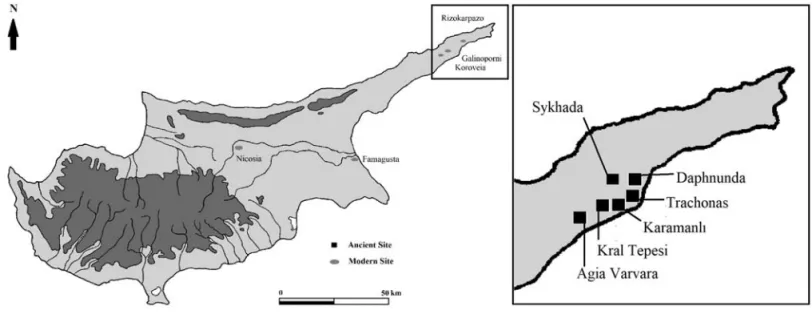
Indeed, the present paper is an attempt not only to overcome the ineffectiveness of this chronological tripartition but also to use the preliminary evidence gathered through a documentary and photographic ex-tensive rural survey to propose a different picture of the development of the Cypriot countryside in the period under scrutiny here. The survey has been conducted in the plain of Galinoporni/Kaleburnu on the southern coast of the Karpas peninsula (Fig. 1). As both the idea of an Arab-Byzantine land and maritime frontier has been recently reassessed (Eger 2015; Picard 2016) pointing to the permeability and the porosity of a sup-posedly firm barrier, it is our intention to try and pair the results of the Galinoporni-Kaleburnu survey with others having as their objects specific areas of other in-sular contexts like Sicily (Kaukana) and the Balearics (Mallorca and south Menorca) (Mascarò 2017; Pelagatti
— Di Stefano 1999). As in the case of
Galinoporni-Kale-burnu, the latter “were not specifically designed to solve questions about Late Antique [and Dark Age] settlement patterns” (Mas Florit — Cau Ontiveros 2007, 171) but they nevertheless used architectural, artistic and ma-terial evidence to catalogue and propose and interim synthesis for the rural world of these islands. In both instances, we are dealing with insular coastal districts and as will be seen with areas that have “no natural frontiers or boundaries if not administrative (artificial) […] as no epigraphic or literary evidence is available” (Mascarò 2017, 1).
More important, both in Kaukana and the Balearics we are still far away from proposing conclusive evidence which could help us understanding and fully document the transformation of urban landscape and the distri-bution patterns of the population in the period under scrutiny (Mas Florit — Cau Otniveros 2007). This mainly because proper archaeological excavations are missing. Nevertheless, they have been able to show that the
so-called Dark Ages should be interpreted less as a period in which Muslim expansion simply engulfed the eco-nomic, social and cultural life of countryside and city alike allowing us to reassess the idea of simply rural fortified sites dotting a rarified landscape. In a similar vein, we cannot simply take for granted that at the time under scrutiny Cyprus was overwhelmed by Arab in-cursions turning the island into a no man’s land, sev-ering commercial and shipping routes, bringing to an end any form of life in the countryside, causing massive depopulation and abandonment of prosperous rural vil-lages along the coasts in favor of hastily built and forti-fied (often seasonal) hilltop settlements. In fact, here we are not discounting the impact of Arab-Byzantine war-fare (peaked in the two failed siege of Constantinople in 674 and 717), the end of the Egyptian fiscal tax-spine, the contraction of production and distribution, and the marked regional decline in supra-regional trade and ex-change beginning in the mid-seventh century (with a nadir in the mid-eighth) as described among the oth-ers by Chris Wickham and John Haldon (Wickham
2004; 2005; Haldon 2012). Rather, we are proposing
a reassessment of the available evidence (in particular ceramics) in order to draw a less gloomy picture of the Cypriot countryside in the transition from Late Antiq-uity to the early Middle Ages.
Indeed, in our opinion, this picture has been the re-sult of archaeological evidence read in retrospect, that is as a confirmation of a picture already sketched through literary and documentary sources. These in turn present us with a score of methodological prob-lems and are often than not later than the events they narrate as well as biased to serve the political-ideologi-cal purpose of the hour (Brubaker — Haldon 2009). As partially mentioned, Michael Decker alerted us to the troubled waters one has to navigate through when em-bracing the idea of Dark Ages. “Dark Ages represents in Byzantium an increasingly problematic term. It is prof-itable [when it is used] to draw attention to the lack of documentary evidence and juxtapose this with the growing body of archaeological material of seventh-to-ninth centuries” (Decker 2016, 187).
With all these caveats in mind and considering that as M. Milwright (2010) states “changes on agricultural practices or rural settlement patterns [nevertheless] usually occur relatively slowly [and …] frequently exhibit little observable correlation with wars, dynastic changes or other major events” (60), it is our intention to propose a picture of the Cypriot landscape as “characterized by a possible continuation of the varied array of rural set-tlements (farms, hamlets and villages) of previous cen-turies” (Vanhaverbeke et al. 2009, 184); this by using as a convenient starting point the results of the exten-sive survey in the Galinoporni-Kaleburnu plain (Fig. 2). We are perfectly aware that this survey presents us with many issues: the first and more important being its lo-cation in the abovementioned problem of its lolo-cation in the so-far “archaeologically inaccessible” northern half of the island. Here we have been less “Indiana Jones” than one could possibly think for we were perfectly aware of the limitations imposed by the International convention regulating archaeological activities in con-flict zone (Harpster 2008, 4, 7–8).
However, as any problem may also be an opportunity in disguise, it is obvious that the Galinoporni-Kale-burnu survey represents yet another reminder of the fact that any archaeologically-based conclusion on the fate and changes experienced by Cyprus in the period under consideration (and even beyond) cannot be pro-posed without taking into account the elephant in the room; that is the total lack of archaeological documen-tation for a territory as large as on third of the island and including the late antique and Byzantine capital of the island (Salamis-Constantia), two urban centers in which residential building and economic activities had already been documented during the late seventh and early eighth centuries (Soloi and Kyrenia), and finally
some rural areas which although partially documented in the pre-1974 period, still escape modern and stra-tigraphically aware investigation. Among these one should mention the Dhiorios-Mersineri settlement and the Kornos cave on the northern side of the Kyrenia range, the Famagusta district and above all the Karpas peninsula, where the Galinoporni-Kaleburnu plain lies.5
In the light of the abovementioned issues, the scope of the current analysis to the monumental evidence and the settlement pattern it mirrors yet without being able to document (and therefore use) the large amount of pottery seen on the ground. We remain, however, con-vinced that the observations resulting from the field walks, photographic surveying of rural churches and mapping of possibly related areas of rural settlement (deduced by remains of building material and pottery shards scattered across them) could be interpreted in a comparative perspective as the settlement pattern which seemed to have characterized the Galinoporni-Kaleburnu plain in the early Medieval period presents us with remarkable similarities with other islands of the Byzantine Mediterranean like Sicily, the Balearics (and partially) Naxos. As will be seen, we can match the sults of the documentary survey with the on-going re-assessment of ceramic assemblages found in other sites of the island as well as in different areas of the eastern Mediterranean to point (again in a comparative perspec-tive) to the strategic relevance that Cyprus maintained
5 On the Dhiorios-Mersineri and Kornos Cave, see Catling 1972
and Catling — Dikigoropoulos 1970, 37–62. On Famagusta dis-trict see Rautman 2004, 193–195; Papacostas 1999, 10 ff; on Karpas peninsula see Megaw 1946, 46–56; Stewart 2008, 22–90; Metcalf 2009, 472–474.
Fig. 2. Overview of the
north-western part of the Galinoporni-Kaleburnu plain (authors’perso-nal archive). — Obr. 2. Přehled severozápadní části planiny Ga-linoporni-Kaleburnu.
lying at the intersection of three regional economies and acting as a stepping-Cstone for cross-frontier and long-distance exchange.
Finally, it seems possible to make some tentative ob-servations concerning the model of rural life in early medieval Cyprus, which although experiencing a con-traction in demographic and economic terms, shows no catastrophic occupational gaps after the mid-seventh century. Here one can indeed look at the recent re-assessment of material evidence proposed for the terri-tory of Sagalassos in Anatolia and Beotia in Greece. Indeed, H. Vanhaverbeke, J. Vroom and A. Vionis have clearly proved that although number of sites decreased and defended villages provided shelter to local popula-tion, the rural landscape in these regions was far than empty with evidence of substantial production of do-mestic wares, long-distance transport and economic links with other areas of the eastern Mediterranean (as showed by imported amphorae), smaller communities quite modest in architectural terms as located in prox-imity of rural churches, and changes in land-use meth-ods (permanent occupation associated to a more pastoral way of living) (Vanhaverbeke et al. 2009, 185 ff.; Vionis
2013b; Vroom 2003).
2. A brief history and archaeology
of the Galinoporni/Kaleburnu plain
The focus of the present survey has been the sub-re-gional landscape of the Galinoporni-Kaleburnu plain. The plain is a flat area of roughly 12 km, length in south-west-north east direction and of 4 km width. It extends in a slight trapezoid form and it is bounded on three sides (north, east and west) by the Karpas hilly
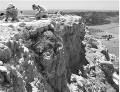
ridge, a bumpy and less rugged continuation of the mountainous spine (Kyrenia range) running parallel to the northern coast of the island. The south side of the plain faces the southern coast of the Karpas peninsula and is in the form of flat sandy beaches. Moreover, the plain is speckled with few steep mounds some of which – although not as large and substantial like the above-mentioned Vasili / Kral Tepesi mound (Fig. 3) – showed spectacular (but not studied or documented) ceramic evidence of human settlement across different ages as proved by the large amount of pottery shards of the Greek and Roman period found scattered on the large areas of the so-called Mesovouni mound (Fig. 5) (Guillou
1998, 11–12). The plain can be approached either by
sea, as many small coves and natural bays along the coast offer convenient but temporary shelter to ships, or by land, through the road connecting the village of Lythrankomi (home of the famous twelfth-century church of Panagia Kanakariá) to Rizikarpazo (Megaw —
Hawkins 1977). The road wiggles from the west end of
the flat area and passes through the villages of Korovia, Galinoporni/Kaleburnu as it then continued its way to the east side of the plain coasting by the sites of Sykhada and Trachonas to reach the tip of the penin-sula where the famous Monastery of Apostolos Andreas is located. There is no documentary or material (as for instance prompted by Roman milestones) evidence that the road system encompassing the whole island of Cyprus extended into the Karpas peninsula. Indeed, the island could boast only one substantial road (Mitford
1980, 1332–1336; Bekker-Nielsen 2004; Pazarli 2009).
Mitford concludes that “on the [fourth-century]
Peutin-ger Table a route is shown following the narrow but easy
coastal plains of the north and south [of Cyprus]. At no great distance to the east of Cerynia this swings inland,
Fig. 3. The Vasili / Kral Tepesi site
(authors’ personal archive). —
Obr. 3. Lokalita Vasili / Kral
and cuts directly through the Kyrenia Range via Chytri to Salamis, bypassing the Karpas peninsula” (Mitford
1980, 1333).
Notwithstanding the lack of relevant documentation, however, we can surmise that the Karpas peninsula was served by a land road, which should have connected the main ring road with the cities of Urania and Carpasia located on its northern coast (Metcalf 2009, 472–474). According to T. Bekker-Nielsen, no substantial land route would have been built across the Galinoporni-Kaleburnu plain as supposedly showed by a detailed re-construction of the roads built in Cyprus between the Hellenistic and the Roman period based on the fourth-century Tabula Peutingeriana as compared with the tracks (often inaccurately) reported by Kitchener in his famous triangulated survey of Cyprus dated to 1878– 1882 (Bekker-Nielsen 2004, 42).6This seems, however,
not the case if we consider that the area seems to have been continuously inhabited and frequented from the
Hellenistic to the Medieval period and even later as proved by the relative dense settlement pattern as doc-umented by sixteenth-century maps. As we will return to this in a few moments, it is interesting to notice that the Karpas peninsula has remained relatively unmen-tioned by the large score of late medieval and early mod-ern travelers which visited the island from the thirteenth century one (Calvelli 2009, 132); moreover, scholarly at-tention has been centered mainly on its churches (like the early Christian basilicas of Agios Philon or Agias Trias and the late medieval ecclesiastical buildings of Aphendrika-Urania while an all encompassing survey of the peninsula is still waiting to be attempted (Du Plat
Taylor — Megaw 1981; Langdale 2009; Stewart 2010).
Courtesy of the recent discovery of two hoards of bronze artifacts, it has been possible to date the first settlement on the Galinoporni/Kaleburnu plain to the Bronze Age (Bartelheim et al. 2008, 161–162;
Kızıldu-man 2008; 2017a; 2017b), although – as partially
men-tioned above – no documentary or literary evidence can shed light on the development of the local settlement pattern in the subsequent periods.7 As A. Stylianou
(1971) points out, the village (and the plain and it is named after) are first mentioned in the Theatrum Orbis
Terrarum (Theatre of the World) written and illustrated
by Abraham Ortelius in the early 1570s (Fig. 6). The atlas included a map of the island Cypri Insulae Nova
Descripta (dated to 1574) which showed the plain as
dotted with three small villages (Galinoporni, Suasili and Sicada (tod. Sykhada around the surveyed church of Panagia Aphendrika). Apart from later versions of
6For the Kitchner’s Map see https://maps.nls.uk/cyprus/
(retri-eved on 01/02/2018).
7 EMU, DAKMAR (Eastern Mediterranean University, Eastern
Me-diterranean Cultural Heritage Research Center) and the Fritz Thyssen Stiftung Foundation have been conducting an emer-gency excavation on the so-called Kral Tepesi mound at the center of the plain since 2005 (Fig. 4). The project has been de-veloped in two stages. The first one took place between 2005 and 2009 and was led by (former) DAKMAR chair Dr. Uwe Müller, the president of the Troy Excavation Committee Dr. Ernst Pernicka from the University of Freiberg, Dr. Martin Bartelheim from the University of Tübingen and Dr. Bülent Kızılduman from the Eas-tern Mediterranean University in Cyprus. The second one started in 2014 and it is currently undergoing. It has been directed by the current DAKMAR’s Chair Dr. Bülent Kızılduman.
Fig. 4. The results of the erosion process (authors’ personal archive). — Obr. 4. Výsledky erozních procesů.
Fig. 5. Mesovouni / Karamanlű site
(authors’personal archive). — Obr. 5. Lokalita Mesovouni / Karamanlű.
Theatrum (like the one dated to 1647 as made by Willem Janszoon Blaeu), no later maps or cartographers (like Fernandus Bertelli or Alphonsus Lazor a Varea) recorded the sites in question. Indeed, it was only in the late nineteenth- early twentieth century (after Cyprus became part of the British empire) that the Galinoporni plain resurfaces courtesy of the abovementioned trian-gulated survey made by Kitchener and the travel log of
David Hogarth (1889), a British explorer and amateur
archaeologist who excavated and traveled in Cyprus in 1887. Hogarth mentions the scenic valleys of the Karpas including the fertile plain of Sykhades east of the village of Galinoporni. According to D. Hogarth (1889, 79), at the village one could see “a hundred other rock-cut graves honeycomb the eastern slope on which the village is built: the houses are often built on to them, and they are used as inner rooms, as store-cham-bers, as stables”. Hogarth’s detailed log is of particular importance as he reports about both a small “Byzan-tine” village on the coast located at the mouth of a small stream called Karamani (in an area which should cor-respond to the site recorded by the present survey as Trachonas) and the two churches of Agia Varvara and Panagia Aphendrika at Sykhada; the latter is indeed mentioned by Camile Enlart, who compiled his famous handbook on the Gothic Art and Architecture of Cyprus just few years after Hogarth’s travel (Enlart 1899, 400– 401). As we will return to his description of the church later, it is worth mentioning that Enlart also visited the village of Galinoporni-Kaleburnu where two small Gothic churches (now completely disappeared) were still
Fig. 6. The Karpas Peninsula with the villages of Sicada, Galinoporni and Suasili. From Abraham Ortelius (publisher), Ioannes a Deutecum (engraver)’s Cypri
Insulae Nova Descripta, 1573, (350 x 495mm) page 52, Theatrum Orbis Terrarum, Antwerp 1574. Latin. (Reproduced with permission). — Obr. 6. Poloostrov Karpaz s vesnicemi Sicada, Galinoporni a Suasili. Z Abraham Ortelius (vydavatel), Ioannes a Deutecum (rytec) Cypri Insulae Nova Descripta, 1573, (350 x 495 mm) str. 52, Theatrum Orbis Terrarum, Antverpy 1574. Latin. (Reprodukce povolena).
standing yet not in use. Local traditions still preserved memories of one of these churches – dedicated to Saint Anne – which still under the British rule was the goal of ceremonial procession especially when the area was affected by serious drought.
Following in the footsteps of D. G. Hogarth, George
Jeffery (1918), the first Curator of Ancient Monuments
in Cyprus (between 1903 and 1935), wrote a description of the historic monuments of Cyprus which mentioned Galinoporni as well as other sites across the plain in-cluding Agia Varvara and Sykhada where the church of Panagia Aphendrika stood in complete ruin.8
The walls are traceable all-round the base, but only fragments of vaulting and arcades remain over the two side aisles. The plan of the church has been of the usual Romanesque barrel vaulted three-aisled terminating in semi-circular apses; but a large narthex has, by dimin-ishing the length, rendered the proportions more in ac-cord with Byzantine traditions. The three bays of this narthex were covered with barrel vaulting, that in the centre in a line with the nave, those on the sides at right angles. Some slight attempt at decoration has been made by giving a moulded impost to the semi-circular arches of the nave arcades (Jeffery 1918, 259–260).
Few years later, it was the turn of the well-known Swedish expedition in Cyprus (dated to the 1920s and
8 For a detailed overview of the first archaeological surveys in
Cy-prus see Davis — Stewart 2014 with further bibliography. See also Hogarth 1889, 74–76.
1930s) to provide us with the first archaeological pieces of information concerning the plain9. Indeed, Einar
Gjerstad, one of its members reported that in 1926 a newly built road badly damaged a necropolis area in the territory of Galinoporni-Kaleburnu allowing him to identify some Middle Bronze Age ceramics (Gjerstad
1926, 11). It is worth mentioning that Rupert Gunnis
referred to some Muslim settlers who built their houses on top of the cemetery documented by E. Gjerstad
(Gun-nis 1936, 238–239). The first and only archaeological
studies and researches in the plain began in April 1928, as led by Erik Sjöqvist, one of the assistants of Gjerstad, and including the sites of Trachonas and Nitoviklia (Mand — Gjerstad 1935, 461–466). These as well as the village of Galinoporni-Kaleburnu were later include in the famous Opuscula Atheniensia (listing the major archeological sites on the island) as published by Hector W. Catling in 1962 although no information concerning the mound was included (Catling 1962, 156–163).
After the pioneering investigations by the Swedish in 1930s the plain and its main sites remained virtually forgotten until A. H. W. Megaw investigated the area. Building on his previous interest in the church of Agios Philon which he excavated with J. Du Plat Taylor, A. H. W. Megaw included the Church of Panagia Aphen-drika in Sykhada in his famous article entitled “Three Vaulted Basilicas in Cyprus” (Megaw 1946). Megaw’s conclusions were based on a small survey of the ruined building and on a comparative study of the two chur-ches located on the site of Urania-Aphendrika on the northern coast of the Karpas Peninsula.10Megaw
as-serted that the churches were built over early Christian basilicas.
The churches must then have fallen into disuse and ruin, if they were not actually burnt by the invaders. At the time of their repair, an incomplete and damaged shell seems to have been all that remained in each case. There is no indication how long the period of abandon-ment was, except that it was long enough for the build-ing technique employed on the original basilicas to have been forgotten and to have been replaced by a distinc-tive vaulted architecture (Megaw 1946, 50).
Megaw’s conclusions were reassessed by A. I. Dikigo
-ropoulos (1961), A. Papagheorgiou (1965) and more
re-cently by C. Stewart (2008) who run an extensive and detailed survey of the ecclesiastical buildings dotting the Karpas peninsula (including those in the Gali-noporni/Kaleburnu plain) and slanted towards a late seventh to mid eighth-century date for both Panagia Aphendrika and Agia Varvara. Stewart’s conclusions were based upon an attentive analysis of the architec-ture, planning, style and building technique boasted by the abovementioned building as paired with similar churches as located in Salamis-Constantia, the Byzan-tine capital of the island, and Paphos. Indeed, Stewart points out that “the churches of Afentrika [like Panagia
Aphendrika and Agia Varvara] were clearly rebuilt as barrel-vaulted basilicas sometime after their original structures were destroyed. Their plans closely followed the earlier basilicas and fully incorporated the apses, indicating that the remains were easily traceable”
(Stew-art 2008, 51). As will be seen, although some doubts
have been cast on Stewart’s conclusions, the date of the so-called barrel vaulted church has still to be chal-lenged and retained its validity as it will be also used in the current paper as harbinger of the resilience and cat-alyst for continuous occupation of the Galinoporni-Kaleburnu plain during the Dark Ages.
3. A shot in the dark:
surveying the Early Middle Ages
in the Galinoporni/Kaleburnu plain
11As Michael Decker has recently pointed out “[extensive and intensive] survey and its cognates […] represent the subfield of archaeological investigation whose principal characteristics are the mapping of terrestrial surface artefacts […] and non-intrusive means of inquiry” (Decker 2016, 124; also Sollars 2003). More important, he also recognized its importance in particular in areas where excavations would be impossible or too costly as well as the role played by surveys in recording informa-tion from larger areas (concerning settlement density, intensity of land use and livestock regimes) and docu-menting materials from different periods of time. In this light, surveys, and in particular, those focusing on the Dark Ages rural landscape have moved beyond a rather “simplistic” quantitative approach to assess the quali-tative aspects of economic life (for instance building ac-tivities and burials), and become the “dominant means by which settlement history is constructed” (Decker
2016, 134; also Veikou 2013). Indeed, Cyprus, as
men-tioned above, has witnessed numerous extensive and intensive surveys as conducted mainly in its southern half (the territory of the Republic of Cyprus). The results of the surveys have often pointed towards the “changing in land-use strategies in response to the collapse of re-gional markets as showed by the lower proportion of pottery finds datable after the sixth century” (Decker
2016, 139). Here, once again, a quantitative approach
seem to tally with the need to prove the decline of eco-nomic, social and material standards of life post-sixth century as enhanced by the tripartite historiographical model. Things being so in the Galinoporni-Kaleburnu survey we have tried to move beyond the idea that scarce pottery sherds or absence of nucleated villages
9 On the Swedish Archaeological Expedition see Whitling 2014. 10 Megaw 1946, 52: “Clearance was limited to the interior; what is
left of the external faces of the apses remains concealed in de-bris, consequently the thickness of their masonry could not be measured”.
11 The survey was run in full compliance of the first and second
protocol of the (Hague) Convention on the Protection of Cultural Property in the Event of Armed Conflict (1956 and 1999) as the team (including students from University of Venice and Univer-sity of Calabria) engaged only with a detailed photographic do-cumentation and mapping of the sites (including measurements of the standing monuments). We would like to thank here Va-lentina Farace, Juna Bazzan, Antonino “Totò” Bucalo e Maria Vittoria “Mavi” Gabriele for their invaluable help and support. This part of the article is indeed ideally dedicated to them. On the (Hague) Convention see Hardy 2010, 92–93; Kızılduman 2008; Şevketoğlu — Tuncel — Şahoğlu 2015.
should be regarded as evidence of a decline of rural human activity.
One should indeed on the lookout for different mark-ers of demographic resilience, economic activity and dif-ferentiated typology of rural settlement patterns. In this light, the surveyed area offers a privileged viewpoint due to both the extraordinary number of religious buildings scattered across a rather concentrated coastal area and evidence of nucleated settlements as well as coastal sites. Unfortunately, as repeatedly stated, the very lim-ited nature of the survey and the restrictions imposed upon by the ban pending on any archaeological inves-tigation in the northern half of the island forced us sim-ply to produce a detailed photographic reconnaissance of the structures and remains (with the idea of docu-menting their current state as compared with the stud-ies produced before 1974) followed by a punctual assessment of their plan and size (intended to update or confirm the mapping produced in previous publica-tions) and finally by an assessment of the important role
Fig. 7a. The site of Trachonas
view towards south (authors’ personal archive). — Obr. 7a. Lokalita Trachona s výhledem na jih.
Fig. 7b–c. Remains of Hellenistic / Roman structures. — Obr. 7b–c. Pozůstatky staveb helenistických / z doby římské.
a
b
c
played by ecclesiastical buildings in the medieval rural landscape.
The Galinoporni-Kaleburnu survey has indeed cov-ered small areas around three settlements centcov-ered around the surviving ecclesiastical buildings (Agia Var-vara, Panagia Aphendrika in Sykhada and Panagia Daphnounda-Monastiraki) as well as a fourth site (Tra-chonas) (Fig. 7) couched on a larger stretch of gently de-grading terraces. The terraces face a small bay where traces of docks and quays can still be observed few inches below the sea. They were often littered by re-mains of larger structures (so far never studied or even scientifically documented) tentatively dated to the Hel-lenistic or possibly Roman period.12
Along the coast traces of quarry activities have been also recognized as large ashlar blocks were clearly cut
12 See Diary from the Swedish Expedition in Cyprus, Oura DII: 1c.
out of the small rock cliffs abutting into the sea. It is impossible to propose a time-span for the activity of these quarries which can be traced along the whole sea-coast of the surveyed area. Their proximity to the bronze age site of Nitovikla, the Hellenistic and Roman port of Urania-Aphendrika, the Late Antique and Byzantine capital of Salamis-Constantia and finally Medieval Fa-magusta could account for the chronologically broad timespan of activity. In particular, in one small site large concentrations of (Roman and Late Antique?) pottery on the surface have been documented as paired with evi-dence of in-situ attempts to carve and model the quar-ried blocks. It is also worth mentioning that once the ashlar blocks were cut out the resulting rectangular carved-spaces were often reused as salt or fish tanks as
a
b
Fig. 8a–b. The Church of Agia
Var-vara (authors’ personal archive). —
Obr. 8a–b. Kostel Agia Varvara.
also documented elsewhere on the island (Lambousa-Lapethos).13
All the above-mentioned sites are located within an eight-kilometer range from each other and present us with possible different typologies of settlements with Agia Varvara (Fig. 8), located two kilometers to the south of modern Korovia on a terrace just few hundred meters from the sea, and Sykhada, possibly representing the foci of a medium-size rural villages, whereas Trachonas (facing the seas just two kilometers to the south-west of Sykhada) could have hosted a small community
ben-13 On the building and use of Roman fish tanks see Zarattini et al.
efiting from the presence of the small harbor and sea-faring activity (as the ruins of some fish tanks would led to believe). Finally, on the summit of a higher hill de
facto closing the northern side of the plain, we
docu-mented a site mentioned in the 1950s cadaster map as Monastiraki and preserving extensive ruins of a small barrel-vaulted church, chamber tombs, two massive caves and other structures for which a possible identi-fication with the site of Panagia Daphnonda is been pro-posed here (Fig. 10).
None of the sites we surveyed has been documented by any literary or documentary source and only the churches of Agia Varvara and Panagia Aphendrika in Sykhada (Fig. 9) have been extensively studied and pub-lished (although never fully excavated) (Megaw 1946, 48–56; Stewart 2010, 171–174).14Pending a detailed
fu-ture examination of the pottery, glass and other mate-rial evidence, which we encountered in our survey as scattered over the surface, one could infer a relative continuous frequentation of at least some of the above-mentioned sites across the Prehistoric, Classical and Medieval (early and later period). It is also interesting to notice the diverse typology of the surveyed buildings: from ecclesiastical edifices like Panagia Aphendrika which boasted at least three chronological phases (a fifth-century basilica, an eighth century smaller three nave church and eleventh-twelfth century rural chapel) or Agia Varvara (where glass mosaic tesserae seem to point to the existence of an earlier phase of the building whose current structure is dated to the eighth century), to a late medieval monastery (Panagia Daphnonda-Monastiraki) (Fig. 10) to chamber-type tombs, and more elaborate town-like structures like that inferred by the presence of well-carved capitals and columns lying in the vegetation on a large terrace in Trachonas.
As already hinted at, it is possible that the three ed-ifices constituted the focus of different agricultural
set-14 On Agia Varvara see Farace 2015.
Fig. 9a. Panagia Aphendrika in
Sykhada (authors’ personal archive). — Obr. 9a. Panagia Aphendrika v Sykhadě.
Fig. 9b. Panagia Aphendrika in Sykhada – Southern nave arcade (authors’
personal archive). — Obr. 9b. Panagia Aphendrika v Sykhadě – arkáda jižní lodi.
a
tlements. In particular, Panagia Daphnonda-Monastira-ki, located in a rather secluded area on a commanding hilltop, seems to fulfill the description of a medieval Byzantine khorion as proposed by E. Akyürek (2008) and J. Lefort (2002). As E. Akyürek (2008) states: “these settlements varied greatly in size [and] were usually es-tablished in places difficult to access and away […] from the main roads, for security reasons [although] not usu-ally encircled with fortifications [and making] use of natural protection” (Akyürek 2008, 298). Not planned organically as need arose, these rural settlements often did not contain any public structures other than churches as central or local political and administrative authorities did not interfere with their development (Akyürek 2008). As will be seen, a similar planning can be documented at Kaukana in Sicily. In fact, the site of Panagia Daphnonda-Monastiraki, which extends over an area about 350 m. long and 250 m. wide around the church, has revealed traces of continuous frequentation predating the medieval period, as it boasts a large score of chamber tombs (at least eighth, which remain unex-cavated or looted and should be similar to those
docu-mented at Trachonas), the ecclesiastical building (of which only the perimetral walls are preserved) and two grottos close to the latter. One should also notice that a large amount of stones, and even a capital possibly belonging to the church could be found scattered around the area.
Although it cannot be seen from the plain or from the coast, it is likely that the flat area on which the church and the tombs are located could be in contact with the plain via the main access on the north of the hill as well as from its east side. The church was a single-nave bar-rel-vaulted church – as proved by the corbels and lower parts of the arches – and was approximately 15 m. long boasting a semicircular apse (which is standing to a height of 0.5 meters. The vault covered the three standing bays while the walls and (possibly) the vault were built with varying size limestone ashlars and reused columns (spolia hinting at the possible existen-ce of first constructive phase). Moreover, that external walls boast a (poor) use of brick patterning which
R. Ousterhout (2006) has defined as one of the
distin-guishing features of Byzantine architecture. This would
Fig. 10a–b. The Church of Panagia Daphnonda
(authors’ personal archive). — Obr. 10a–b. Kos-tel Panagia Daphnonda.
a
provide a tentative and rather loosen terminus post
quem for the building of the vaulted church (pending
comparative studies with other buildings on the islands) for this type of decorative pattern appeared in Con-stantinople in the ninth and tenth century and beca-me more common from the eleventh century onwards (Ousterhout 2006, 194–200). Indeed, we are confronted by a very poor attempt of imitating a type of surface brick ornamentation which is better outlined in larger and richer Byzantine ecclesiastical buildings. Neverthe-less, this could point to some sort of contacts of the local clergy (or monastic community) with Constantino-ple and other regions of the Byzantine Mediterranean.
The edifice itself is not well preserved notwithstand-ing the south and northern wall still standnotwithstand-ing in their full height, as the roof has completely collapsed de facto filling the entire nave and hampering any attempt to lo-cate and document the floor. A deep hole has been dug in correspondence of the apse pointing to the activity of looters (also documented in many of the tombs). The church presents no lateral openings as only one small triangular window opens in the middle of the southern wall. The poor state of preservation of the ruins did not allow us further investigations for excavations are re-quired to clarify status, chronology and function of the building and the existence of possible small annexes. The proximity with the two caves (located few meters to the north of the church and curiously reminding us of the subterranean shrine at Aphendrika-Urania (Stewart
2010, 164) as well as the analysis of the building
tech-nique and the scanty use of spolia could point to a me-dieval date and may infer to the continuous importance of the building as a local pilgrimage site.
Here, however, further research is necessary, in par-ticular on the origins of the toponym Daphnonda (which seems to be the name the local inhabitants attributed to the site). Although it is not always possible to date the buildings of the island according to their masonry, the presence of a large amount of pottery shards (both transport containers, coarse wares and fine wares, some possibly dating back to the Roman period) and furnace wastes could suggest the presence of either a small monastic chapel which would be related to a small village (“the most fertile land in the [Byzantine] countryside was owned by the monasteries [which] acted like feudal landlords in many rural settlements”) or a church located in between houses or even a funer-ary chapel (with a local importance as pilgrimage site).15
It is nevertheless possible to regard the abovemen-tioned site as an integral part of the rather complex and differentiated medieval settlement pattern boasted by the plain. Here the two other churches documented during the survey are of the utmost importance to re-construct the functional organization of the rural set-tlement pattern across the plain. The first one, Panagia Aphendrika, as Stewart asserts, “stood near a settle-ment called Sykhada, which is now deserted. The to-ponym sykhada (
σyκa
) means “fig” and could possibly be the town where the ninth-century Demetrius, bishop of Chytroi, was born” (Stewart 2010, 171–172). As already mentioned, it is a three-nave barrel-vaultedchurch, which was built over a preexisting sixth century basilica in the eighth century (Stewart 2008, 46). The second building, Agia Varvara is located not far away from the coast, few kilometers to the south-west of Panagia Aphendrika. Although in a ruinous state as only the northern wall and the pier arcade stand, it is clear that the church was almost contemporary to Panagia Aphendrika as it is also barrel-vaulted and built over a previous early Christian basilica. The large amount of blue stone and glass mosaic tesserae scat-tered across the southern nave point unequivocally to the mosaic decoration of this basilica.16Both churches
have been exhaustively studied by A. H. S. Megaw (1946), A. Papageorghiou (1985) and C. Stewart (2008;
2010), who have described their architectural history
and their decoration (a stunning interlaced wheel-pat-tern Umayyad fresco motifs survives in Agia Varvara (Fig. 11) but no attempt has been made to contextualize the building as part and parcel with the rural world of the plain in the period of their construction (that is in
15 The quotation is from E. Akyürek 2008, 302.
16 Some of these tesserae still show traces of golden-leaf decoration
and lie on the ground as mute witness of the wealthy decoration of the basilica, which lies underground. Unfortunately, it is not possible to collect and therefore analyze them in further detail.
Fig. 11. The eighth-century fresco on the southern arcade of the church of
Agia Varvara (authors’ personal archive). — Obr. 11. Freska z 8. století, jižní arkáda kostela Agia Varvara.
the so-called Dark Ages of Byzantium). Indeed, it is to this issue we want now to move.
In our opinion this should allow us to offer an interim synthesis of the Medieval rural settlement pattern across the plain as assessed in a comparative perspec-tive which we regard as the best way to circumvent the abovementioned impossibility of conducting systematic archaeological excavations or surveys. In particular, we will present the reader with a comparison with other in-sular contexts were only extensive preliminary surveys have taken place (like in Sicily or at Cabrera, Mallorca and Saint Lluís in Menorca) or where small churches seem to have filled the rural landscape (Naxos) in the period under scrutiny; this in the hope of providing a methodologically balanced assessment of the role played by ecclesiastical building in the (re)-organization of the local rural settlement pattern in the passage from Late Antiquity and the early Middle Ages. We are per-fectly aware that this can be regarded purely as a shot in the dark or worse as a futile exercise of academic imagination, nevertheless we strongly believe it is a good way to put the disappearing cultural heritage of north-ern Cyprus to the best possible scientific fruition while at the same time preparing the ground for possible fu-ture (and non-) investigation, and analysis of the mate-rial evidence documented to this date.
4. Comparing what is hidden from sight:
rural settlements in the Balearics,
Sicily and Naxos
The Balearics present us with a similar historiographi-cal challenge to the one encountered in Cyprus. Indeed, historians have too often lingered on the idea that the first Arab raid against the Balearics (dated to 707) sup-posedly ushered the islands into a Dark Age which was characterized by a status of political semi-independen-ce, economic regression and an ambivalent although peripheral role along the frontier between the Christian and the Muslim halves of the western Mediterranean (Signes-Codoñer 2005). In a similar vein to Cyprus, the historiographical narrative concerning the early me-dieval period in the Balearics was based upon the ar-chaeology and in particular the results of the excavations of a large number of early Christian basilicas as all dated to the late fifth century-early sixth century.17
These ecclesiastical edifices often boasted large mosaic floors although they had a rather smaller size than their Cypriot counterparts (Ontiveros — Mas Florit 2013, 37–39). However, some of these basilicas have indeed showed evidence of later frequentation well into the eighth century as for instance enhanced by two golden solidi (dated to 737–738) yielded in the basilica of Son Fedrinet in Mallorca where building activity may have continued in the Muslim period.18 Archaeology and
analysis of material indicators seem indeed to point to
17 On these basilicas see Vizcaino 2009, 509–527; Orfila /ed./
2006, 228–239.
18 On the coins see Bordoy 2006 (quotation from p. 311) with
fur-ther bibliography; on Son Fadrinet see Ontiveros — Mas Florit 2013, 39 and Vizcaino 2009, 472–474.
a very late abandonment of at least some of these basil-icas (Ontiveros — Mas Florit 2013, 39).
In this light, it is interesting to notice that some of the ecclesiastical buildings played an essential role in the settlement patterns of the Balearics’ countryside. They seem to have often served the purpose of aggluti-nating local nucleated and non-nucleated settlements for as Mas Florit and Cau Ontiveros (Mas Florit —
On-tiveros 2007; OnOn-tiveros — Mas Florit 2013) conclude
“al-though the reduction of site numbers is clear, the settlement patterns do not seem profoundly modified. […] There is no evidence of an extensive flight to the hills” (Mas Florit — Ontiveros 2011, 210). A further ex-ample of this peculiar settlement pattern can be found in the southern part of the island of Menorca in the ter-ritory of Sant Lluís. Here, notwithstanding the absence of early Christian basilicas, metal object as found in dif-ferent sites of the area point to the continuous presence of settlement and people until the late ninth century with a possible military connotation of some of the in-habited sites as located both on the hinterland as well as along the coast (Mascarò 2017).
A recent reassessment of the evidence yielded by Sicilian rural surveys as recently summarized by
A. Molinari (2013) and E. Vaccaro (2013) have similarly
countermand the narrative of hastily retreating of local population to fortified hilltop settlements. This does not imply that fortified farms or small villages did not dot the local landscape. Indeed, in the Balearics we could prove that fortified settlements (Alarò and Santueri) ex-isted next to churches like Ses Fraeres and Son Peretò sitting along communication routes or used to gather people living in their proximity whereas others were lo-cated on the coastline and visible from the sea
(On-tiveros — Mas Florit 2013, 38). In a similar vein in
Kaukana located on the south-eastern coast of Sicily the survival of a Late Antique settlement along the coast pairs with scattered villages and fortified farmsteads lo-cated on its hinterland (as occupied well into the eighth century) (Pelagatti — Di Stefano 1999, 39–40). The Si-cilian comparison is even more important here as the “results of past and recent field surveys have produced an increasing number of datasets on the settlement net-work in the long period from Roman to the Middle Ages” (Vaccaro 2013, 36). These in turn have led to reinterpret the traditional narrative of incastellamento as a conse-quence of the creation of a theme on the island on the part of Byzantine authorities. Only in a few instances the origins of fortifications or hilltop sited can harken back to the early medieval period as large and unde-fended rural sites mainly appear in the lowlands or the plateau and even on the coast (Vaccaro 2013, 40–43).
Moving to a different regional context, in Naxos (in the Aegean half of the so-called Byzantine hinterland (Wickham 2005, 29), as A. Vionis has recently asserted, “dark ages” rural chapels pairs with pottery fragments recovered around them “testified to the existence of small and large settlements associated with this eccle-siastical monuments. Interestingly enough, sites of this period are not merely restricted to the interior of the is-land but also close to the coast” (Vionis 2013a, 113). More important, Naxos has been recently proved to be a zone of cultural interaction as enhanced by aspects
of material culture and settled landscape (Vionis 2017). Indeed, analysis ceramic evidence yielded around some of the late seventh, eighth or ninth century ecclesiasti-cal buildings (as dated by their aniconic frescos and decorations) has led A. Vionis to conclude that the is-land was not desolated in the trouble period of Arab raids but boasted the importance of the island as hub of a regional network of communication linking together two supposedly antagonistic powers (Vionis 2017, 174). Indeed, the examples of the Balearics, Sicily and Naxos can help to shed some light on the architectural evi-dence as documented in the survey of the Galinoporni-Kaleburnu plain.
On the one hand, it is indeed possible to interpret the restoration of Panagia Aphendrika and Agia Varvara and transformation into barrel-vaulted churches as a sign of demographic and economic resilience. As Aphendrika was located farther away from the coast than Agia Varvara the two churches could have been played a rather complementary role in the local settle-ment pattern; a role further supplesettle-mented by a (monas-tic?) site perching above the top of a hill although out of sight from the coast (Daphnounda) and the survival of a possible coastal outlet (harbor) for needs of the local communities. Indeed, as in the eighth-century Balea-rics, the local rural landscape seems to present us with a coast-hinterland dichotomy. According to Ontiveros and Mas Florit: “the basilicas of the hinterland were parishes as well as productive areas that exploited the resources of the territory and were interconnected with other sites in their surroundings [some of them located on high hills other fortified] while the coastal examples were more likely linked to a port community and its ac-tivities, not excluding a parochial role” (Ontiveros — Mas
Florit 2013, 38). This, and in tune with the evidence
un-earthed in Sicily and Naxos, would disprove the idea of a simple demographic retrenchment on the part of the local Cypriot rural communities away from the coast as the survivors of the Arab incursions regrouped around fortified settlement on the hilltops.
In the light of this evidence it also worth mentioning that the monumental evidence tallies with the result of the analysis of locally made pottery as yielded by pre-1974 surveys in northern Cyprus and later in the Re-public of Cyprus. In fact, although the volume of shipping and the amount of local production were de-clining, hand and wheel-form pottery, ranging from plain tableware to cooking ware and storage vessels, continued to be manufactured in Cyprus well into the eighth century. Plain vessels and coarse fabric cooking wares have been found in different rural sites on the is-land (on sites like Kornos Cave and Dhiorios, located on the northern coast) as they do not show a fundamental cultural break following the mid-seventh century Arab raids but rather as shift in the scale of pottery produc-tion along similar lines to Syrian and Palestinian mate-rial culture
As the Cypriot countryside was therefore not de-serted, one can stress with M. Decker, the increased im-portance assumed by local “vernacular” pottery in the seventh-to-ninth century; this however was not limited to domestic consumption but could sometimes indicate modest local surpluses and commercialization as well
as changing diet and rural conditions (as dictated by a increased reliance on animal husbandry) (Decker
2016, 172). This is also enhanced by the mushrooming
of barrel-vaulted local churches which started appear in the eighth century particularly (but not exclusively) on the Karpas peninsula showing considerable local sources and vitality. If we pair the latter evidence with the results of the surveys held in Naxos, Sicily and the Balearics, we can conclude with Ontiveros and Mas Florit that “the establishment of churches […] even in difficult to reach locations […] gave the community a shared identity linked with the surrounding land-scape [and] emphasize the community’s rural territory” (Ontiveros — Mas Florit 2013, 41).
5. Conclusions
The survey of the Galinoporni-Kaleburnu plain offers a glimpse into the reality of post-seventh century rural life for it shed some light on the possible fate of farmers who adopted rather differentiated strategies of survival and quite flexible settlement patterns even within the same sub-regional contexts. Indeed, the rather limited (in scope and methodology) survey we have conducted has not only revealed the existence of the “expected” (i.e. a rather secluded and hilltop rural settlement with no public buildings as centered around a monastic (?) church) as well as the “unexpected” (i.e. a costal vs. in-land, highly functionalized rural foci of settlement which wedded with the material evidence yielded in other islands of the Byzantine empire (like Sicily, Naxos and the Balearics).
First, and notwithstanding the rather limited evidence and the lack of any pottery sampling or real excavations and considering the geomorphological peculiarities of the Karpas peninsula, it seems clear that to the contrary of what M. Rautman and M. McClellan concluded almost twenty years ago – the farmers were not all gone in Cyprus (Mcclellan — Rautman 1995).19At least in some
parts of the islands rural sites continued to be occupied and coastal settlements were not abandoned in favor of inland fortified sites. Here a quite interesting compari-son can be proposed with the hinterland of the Anatolian city of Sagalassos where – as M. Decker asserts – the end of the urban activities in the second half of the sev-enth century was contemporary to “an increase in [rural] sites and a rise in the ratio of villages to farms [reflecting] a more natural dynamic that prevailed for centuries be-fore the intrusion of Greco-Roman urbanism” (Decker
2016, 143).
Second, the refinement of chronology of Cypriot coarse and kitchen wares as found in different areas of the is-lands could point to the demographic, social and eco-nomic resilience of the countryside, although predicated upon a variety of settlement types (in terms of size, den-sity, location and functionality) for in the area of Galino-porni-Kaleburnu eighth-century barrel vaulted churches are a clear indicator of settlement.
19 The title of their article centered on the Medieval Cypriot
Third, the presence of coastal sites or of possible har-bor installations in the surveyed plain could also point to the role played it played in provisioning and supply-ing the Byzantine capital of the island Salamis-Con-stantia which remained active as main ecclesiastical and administrative focus of the island well into the ninth-century (Zavagno 2013). This in turn would stress the survival and resilience of local landowning elites who (as showed in other Byzantine insular con-texts like Sardinia or the Naxos) supported the efforts of the local rural communities and most probably par-tially sponsored the erection and decoration of local ec-clesiastical buildings.
It is clear to us that the abovementioned assertions have to be further tested as on should try and map other Medieval residential hubs and/or ecclesiastical buildings across the plain and on the hills at its very edge. Indeed, it is quite compulsory to underscore the difficulties, which such endeavor is going to face in the lack of proper excavations; without them one can only dream of reaching the usual standards of surveying ac-tivity both in terms of methodology, analytical approach and conclusive interpretations. But the alternative would be even more painful to consider as it will lead us to relive the fate of the medieval town of Sijilmasa (on the fringe of the Sahara desert) as described by Amin Maloouf:
“of its walls, once so high, only few sections remains, half ruined and covered with grass and moss. Of its population, there remain only various hostile clans each living in a fortified village near to the ruins of the former [city]. Their main concern is to make life difficult for the clan living in the neighboring village. They seem merci-less towards each other […] so it seems to me that they deserve their fate” (Maloouf 1994, 157).
Souhrn
Průzkum planiny Galinoporni-Kaleburnu nabízí vhled do reality venkovského života od 7. století, neboť objasňuje možný osud ze-mědělců, kteří v totožném sub-regionálním kontextu přijali dosti odlišné strategie přežití a poměrně flexibilní sídelní vzory. Poměrně omezený (co do rozsahu a metodologie) průzkum, který jsme usku-tečnili, odhalil nejen existenci „očekávaného“ (tj. spíše skrytých vý-šinných venkovských sídlišť bez komunálních budov, soustředě-ných kolem klášterního /?/ kostela), ale i „neočekávaného“ (tj. po-břežních – oproti vnitrozemským, vysoce funkcionálních ohnisek venkovského osídlení, úzce spjatých s materiálními pozůstatky po-cházejícími z jiných ostrovů Byzantské říše, jako Sicílie, Naxos a Baleárské ostrovy).
Předně, nehledě na poměrně omezené nálezy a absenci vzorko-vání keramiky nebo systematického výzkumu a berouce v potaz geomorfologické zvláštnosti poloostrova Karpaz, se zdá jasné, že – oproti závěrům M. Rautmana a M. McClellana před téměř dvaceti lety – z Kypru nezmizeli všichni zemědělci (Mcclellan — Rautman 1995).20Alespoň v některých částech ostrova osídlení venkovských
sídel pokračovalo, a pobřežní sídla nebyla opuštěna ve prospěch vnitrozemských opevněných lokalit. Nabízí se zajímavé srovnání se zázemím anatolského města Sagalossos, kde – jak tvrdí M. Decker – byl konec urbánních aktivit v druhé polovině 7. století současný s „nárůstem [venkovských] lokalit a zvýšením podílu vesnic vůči
20 Název jejich článku zaměřeného na středověký kyperský venkov
byl opravdu “Where have all farmers gone?” (“Kam zmizeli všich-ni zemědělci?”).
statkům [odrážejícím] přirozenější dynamiku, která přetrvala po staletí předcházející průniku řecko-římského urbanismu“ (Decker 2016, 143).
Za druhé, zpřesnění chronologie kyperské hrubé a užitkové ke-ramiky z nálezů v různých oblastech ostrovů by mohlo poukázat na demografickou, společenskou a hospodářskou rezistenci ven-kova, byť předvídanou na základě rozmanitosti druhů osídlení (co do velikosti, hustoty, umístění a funkcionality), neboť pro oblast Galinoporni-Kaleburnu jsou v 8. století kostely s valenou klenbou jasným indikátorem osídlení.
Za třetí, přítomnost pobřežních lokalit nebo možných přístav-ních objektů na zkoumané planině by mohla poukazovat na roli, kterou hrála v zásobování byzantského hlavního města ostrova Sa-lamis-Constantia, které zůstalo aktivní jako hlavní církevní a ad-ministrativní středisko ostrova hluboko do 9. století (Zavagno 2013). To by zároveň zdůraznilo přežití a rezistenci místních elit-ních vlastníků půdy, kteří (jak je zřejmé z jiných byzantských os-trovních kontextů, jako je Sardinie nebo Naxos) podporovali snahy místních venkovských komunit a pravděpodobně částečně finan-covali stavbu a výzdobu místních církevních budov.
Jsme si vědomi, že výše uvedená tvrzení musí být dále prově-řena – měla by být zmapována další středověká sídelní střediska a/nebo církevní budovy na celé planině a na pahorcích při jejím okraji. Je však důležité zdůraznit potíže, kterým bude toto úsilí čelit ve světle absence řádných archeologických výzkumů, bez nichž je těžko možné dosáhnout obvyklých standardů průzkumných aktivit jak co do metodologie, tak analytického přístupu a průkazné in-terpretace. Druhá možnost by nicméně byla ještě horší, protože by nás přiměla znovu prožít osud středověkého města Sijilmasa (na okraji saharské pouště), jak ho popisuje Amin Maloouf (1994, 157): „z jeho hradeb, kdysi tak vysokých, zůstalo jen pár segmentů, po-lorozpadlých a pokrytých trávou a mechem. Z jeho obyvatel zbývá jen několik znepřátelených rodů, žijících odděleně v opevněných vesnicích poblíž rozvalin bývalého [města]. Jejich hlavním zájmem je ztížit život klanu žijícímu v sousední vesnici. Zdají se být vůči sobě nelítostní […] a tak se mi zdá, že si svůj osud zaslouží.“
Český souhrn Sylvie Květinová
References
Primary Sources
Anastasius of Sinai:Quaestiones et Responsiones. Richard, J. and M. Munitiz, M. /eds./: Anastasii Sinaitae: Quaestiones et responsiones, CCSG 59. Turnhout, 2006.
Theophanes:
Mango, C. — Scott, R. /eds./: Chronicle. Oxford.
Secondary Literature
Akyürek, E. 2008:Palamutdüzü: A Medieval Byzantine Village Settlement in the Bey Mountains. Adalya XI, 295–316.
Bartelheim, M. et al. 2008:
Bartelheim, M. — Kızılduman, B. — Müller, U. — Pernicka, E. — Tekel, H.:
The Late Bronze Age Hoard of Kaleburnu Kral Tepesi in Cyprus. Památky archeologické 99, 161–188.
Bekker-Nielsen, T. 2004:
The Roads of Ancient Cyprus. Copenhagen. Bombico, S. 2015:
Salted Fish Industry in Roman Lusitania: Trade Memories be-tween Oceanus and Mare Nostrum. In: Tjemudo Barata, F. — Rocha, J. M. /Eds./: Heritages and Memories from the Sea. Lisbon, 19–38.