HARBOR SETTLEMENT PATTERNS OF THE SECOND
MILLENNIUM BC IN CILICIA AND THE AMUQ
A Master’s Thesis
by
SEVİLAY ZEYNEP ORUÇ
Department of Archaeology İhsan Doğramacı Bilkent University
Ankara January 2013
HARBOR SETTLEMENT PATTERNS OF THE SECOND
MILLENNIUM BC IN CILICIA AND THE AMUQ
The Graduate School of Economics and Social Sciences of
İhsan Doğramacı Bilkent University
by
SEVİLAY ZEYNEP ORUÇ
In Partial Fulfilment of the Requirements for the Degree of
MASTER OF ARTS
in
THE DEPARTMENT OF ARCHAEOLOGY
İHSAN DOĞRAMACI BILKENT UNIVERSITY ANKARA
I certify that I have read this thesis and have found that it is fully adequate, in scope and in quality, as a thesis for the degree of Master of Arts in Archaeology.
--- Dr. Marie-Henriette Gates Supervisor
I certify that I have read this thesis and have found that it is fully adequate, in scope and in quality, as a thesis for the degree of Master of Arts in Archaeology.
--- Dr. İlknur Özgen
Examining Committee Member
I certify that I have read this thesis and have found that it is fully adequate, in scope and in quality, as a thesis for the degree of Master of Arts in Archaeology.
--- Dr. Ekin Kozal
Examining Committee Member
Approval of the Graduate School of Economics and Social Sciences
--- Dr. Erdal Erel
Director
iii
ABSTRACT
HARBOR SETTLEMENT PATTERNS OF THE SECOND
MILLENNIUM BC IN CILICIA AND THE AMUQ
Oruç, Sevilay Zeynep M.A., Department of Archaeology
Supervisor: Assoc. Prof. Dr. Marie-Henriette Gates January 2013
This thesis is a study on harbor settlement patterns in the northeastern Mediterranean of the second millennium BC based on geo-archaeological evidence. The purpose of the thesis is to assess a hypothesis that estuaries (river mouths/ outlets) acted as harbors for settlements in Cilicia and the Amuq. In order to pursue the hypothesis further, river transport and inland river harbors are proposed. The thesis will attempt to answer questions such as how harbor settlements can be inferred from archaeological and geomorphological evidence and how archaeology identifies river harbor settlements.
Keywords: Harbor settlement patterns, estuary, river transport, MBA and LBA
iv
ÖZET
KİLİKYA VE AMİK OVASI’NDA M. Ö. İKİNCİ BİN LİMAN
YERLEŞİM DOKULARI
Oruç, Sevilay Zeynep Yüksek Lisans, Arkeoloji Bölümü Tez Yöneticisi: Doç. Dr. Marie-Henriette Gates
Ocak 2013
Bu tez jeo-arkeolojik kanıtlara dayanarak kuzeydoğu Akdeniz’de M.Ö. İkinci bin liman yerleşim dokuları üzerine bir çalışmadır. Bu tezin amacı haliçlerin (nehir ağızları/çıkışları) limanlar olarak görev yapmış olduğu hipotezini Kilikya ve Amik Ovası’ndaki yerleşimler için değerlendirmektir. Bu hipotezi takip etmek için, nehir taşımacılığı ve iç/karasal nehir limanları önerilir. Bu tez liman yerleşimleri arkeolojik ve jeomorfolojik kanıtlardan nasıl anlaşılabilinir ve arkeoloji nehir limanı yerleşimle-rini nasıl tanımlar gibi soruları cevaplandırmaya çalışacaktır.
Anahtar kelimeler: Liman yerleşim dokuları, nehir ağzı, nehir taşımacılığı, OTÇ ve
v
ACKNOWLEDGEMENTS
I am deeply indebted forever to my supervisor Assoc. Prof. Dr. Marie-Henriette Gates, for her great encouragement and valuable guidance throughout this thesis. She gave her time to read and correct my thesis. Without her patience and strongly support, I would never have been able to complete this thesis.
I would like to express my gratitude to Assoc. Prof. Dr. İlknur Özgen for her valuable and constructive comments on this thesis, and to Dr. Ekin Kozal who was always ready to offer advice and support this study.
I would like to thank Prof. Dr. Mirko Novák, who was encouraging me to study on the Cilician harbor settlement patterns during the excavation project of Sirkeli Höyük.
I warmly thank Dr. Lucy Blue, for her generosity to send me some parts of her PhD dissertation without question for giving support this study.
I also owe much to my all friends from this faculty for their friendship and support. My special and endlessly thanks go to my family who has consistently supported me during the writing of this thesis and in whatever I wanted to do.
vi
TABLE OF CONTENTS
ABSTRACT... iii ÖZET... iv ACKNOWLEDGEMENTS... v TABLE OF CONTENTS... vi LIST OF MAPS... ix LIST OF FIGURES... x ABBREVIATIONS... xiii CHAPTER 1: INTRODUCTION... 11.1 Geographical Scope of the Thesis... 3
1.2 Methodology... 4
CHAPTER 2: LANDSCAPES OF CILICIA AND THE AMUQ... 7
2.1 Geomorphology of the Region of Cilicia... 7
2.1.1 The Göksu Valley... 7
2.1.2 Çukurova/Plain Cilicia... 8
2.1.3 Dörtyol and Erzin Plains... 11
2.2 Geomorphology of the Region of Amuq... 12
2.3 The Geomorphology of Regional Sites... 14
vii 2.3.1 Tarsus-Gözlükule Höyük... 14 2.3.2 Kinet Höyük... 15 2.3.3 Sabuniye Höyük... 17
CHAPTER 3: ARCHAEOLOGICAL EVIDENCE FOR HARBOR SETTLEMENT PATTERNS... 18
3.1 The Landscape as Evidence for Harbor Settlements... 18
3.2 Artifacts as Evidence for Harbor Settlements... 22
3.2.1 Ceramics... 23
3.2.2 Local Trends in Ceramics Styles... 25
3.2.3 Shipwrecks and Their Cargoes... 26
3.2.4 Boats... 28
3.2.5 Marine Industries... 28
3.3 Architectural Features Specific to Harbors... 29
CHAPTER 4: THE IMPORTANCE OF RIVERS AND RIVER TRANSPORT... 31
4.1 River Transport... 32
4.2 River Boats... 34
CHAPTER 5: THE ARCHAEOLOGY OF REGIONAL HARBORS... 43
5.1. Western Cilicia/Rough Cilicia... 43
5.1.1 Kilise Tepe... 43
5.2. Cilician Plain/Smooth Cilicia... 46
5.2.1 Soli Höyük... 46
5.2.2 Mersin-Yumuktepe Höyük... 47
5.2.3 Tarsus-Gözlükule Höyük... 48
viii 5.2.4 Kazanlı... 50 5.2.5 Domuz Tepe... 52 5.2.6 Sirkeli Höyük... 53 5.2.7 Karahöyük/Erzin... 55 5.2.8 Kinet Höyük ... 56
5.3 A Transition Zone between Cilicia and the Amuq... 58
5.3.1 Dağılbaz Höyük... 58
5.4 The Amuq Valley and the Asi Delta Plain... 58
5.4.1 Tell Atchana/Alalakh... 58
5.4.2 Sabuniye Höyük/Sabouniyeh... 61
5.5 The North Syrian Coast/The Jebleh Plain... 63
5.5.1 Ugarit/Ras Shamra... 63
5.5.2 Minet el-Beidha... 66
5.5.3 Ras Ibn Hani... 68
5.5.4 Tell Tweini/Gibala... 69
CHAPTER 6: REGIONAL HARBORS UNDER HITTITE CONTROL... 73
CHAPTER 7: CONCLUSION... 84
BIBLIOGRAPHY... 92
MAPS... 112
ix
LIST OF MAPS
Map 1: Geographical scope of the study... 113
Map 2: The Göksu Valley... 114
Index of Cilician Sites on Map 3... 115
Map 3: Plain Cilicia... 116
Map 4: The Asi Delta Plain and the Amuq... 117
x
LIST OF FIGURES
Figure 1: Developmental stages of the Göksu plain,
phase I showing the first stage... 119
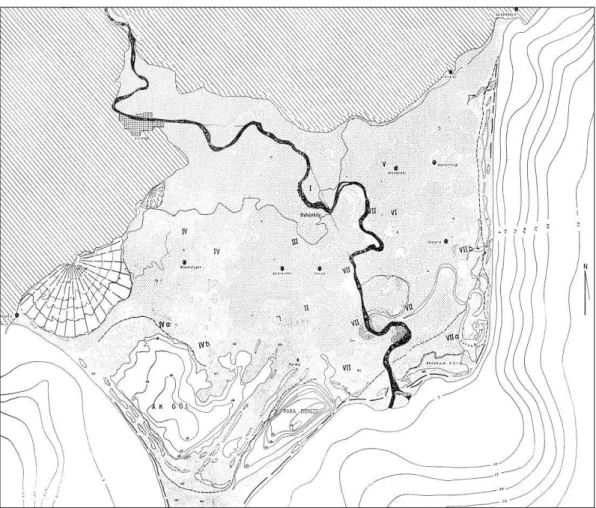
Figure 2: Developmental phases of the Tarsus plain, stage 5a-b showing the shoreline of the mid-Holocene... 120
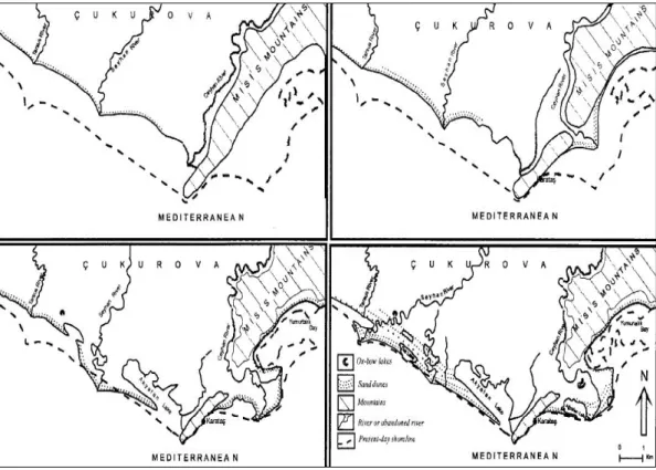
Figure 3: The evolution of the Ceyhan river... 121
Figure 4: Map showing the plains of Dörtyol and Erzin... 122
Figure 5: Developmental phases of the Asi (Orontes) delta plain... 123
Figure 6: Geomorphologic map of the Kinet Höyük area, map showing the oldest Deli river... 124
Figure 7: Kinet Höyük, Operation R showing stratigraphic units... 125
Figure 8: Geomorphologic map of the Asi delta plain showing soundings... 126
Figure 9: Map showing MB river harbors along the middle part of the coastal Israel... 127
Figure 10: A commercial container from Uluburun, the Canaanite jar... 128
xi
Figure 12: Commercial containers, the Cypriot pithos... 129
Figure 13: Commercial goods, the Cypriot fine ware... 129
Figure 14: An example for local trends in ceramic styles from Tell el Dab’a... 130
Figure 15: A gold pendant from Uluburun showing a representation of Astarte... 130
Figure 16: A boat depiction on an Ugaritic cylinder seal... 131
Figure 17: A boat depiction on a faience seal from Ugarit... 131
Figure 18: A depiction of boat on a Canaanite jar handle from Tell Tweini... 132
Figure 19: The shipshed at Kommos... 132
Figure 20: Illustrations of hauling river boat on the Euphrates river... 133
Figure 21: Mortise-tenon joints... 134
Figure 22: A MBA terracotta model of boat from Anatolia... 134
Figure 23: Langlois’ gravure showing boats on the Seyhan in the 19th century AD... 134
Figure 24: The main shapes of Red Lustrous Wheel Made Ware... 135
Figure 25: Late Mycenaean sherds 2, 5, 7 from Kazanlı and 8 from Tarsus... 135
Figure 26: Sirkeli Höyük, geo-electric profile 5 showing the wall of a dock... 136
Figure 27: Sirkeli Höyük, geo-electric profile 1 showing a wall east of the channel... 136
xii
Figure 28: The topographic map of Sirkeli Höyük,
showing an artificial channel of the Ceyhan river... 137
Figure 29: Tell Atchana, wall paintings in Minoan fresco technique... 138
Figure 30: Tell Atchana, some imported Late Cypriot ceramics... 138
Figure 31: Map showing the relationship between Ugarit and its harbors, Minet el-Beidha and Ras Ibn Hani... 139
Figure 32: Map showing the Ugaritic Kingdom and its harbor towns... 140
Figure 33: Tarsus, a Hieroglyphic bulla with the personal name Isputahsu... 141
Figure 34: Kilise Tepe, an ivory stamp seal... 141
Figure 35: Soli Höyük, a Hieroglyphic bulla with the personal name Targasna... 141
Figure 36: Yumuktepe, Building levels VII-V showing a casemate system... 142
Figure 37: Kinet Höyük, a stamped Canaanite jar handle with a Hittite official seal... 143
xiii
ABBREVIATIONS
BP: Before Present
EBA: Early Bronze Age
MBA: Middle Bronze Age
LBA: Late Bronze Age
EIA: Early Iron Age
MIA: Middle Iron Age
LIA: Late Iron Age
1
CHAPTER 1
INTRODUCTION
Landscapes have been modified by people to meet their essential needs such as shelter, subsistence and transport. The harbor settlement, which is one of the forms of land use, was established on the basis of indispensable needs such as available water, and subsistence, such as an agrarian area or source of raw materials. The land should also be sheltered. At the same time it should be accessible like every settlement but include a harbor on an approachable coastline (Vann, 1997: 308). Waterfronts are chosen according to some favorable conditions specific for a harbor location: to be sheltered against strong winds, waves and bad weather conditions, to provide access both to inland and overseas routes, and to offer suitable physical conditions for lifting boats and docking facilities.
Harbor sites supply economic and social needs through their maritime activities. Harbors offer safe anchorages for vessels to transport people and goods, storage facilities for goods and other maritime activities like ship-building, fishing and commercial transport on boats (Frost, 1995: 2; Raban, 1995: 139). Harbors make it possible to reach islands, which are inaccessible without seafaring. Heavy goods are shipped more easily by boat, which can hold a larger volume and weight in one
2
vessel than could be transported by animal (Monroe, 2007: 14). The movement of goods by boat is also faster than overland transport in suitable weather conditions (Panagiotopoulos, 2011: 37-38). Harbors boost the economy of the settlement and its region. They can enhance and enrich culture and knowledge via the movement of ideas by boat.
Bronze Age maritime exchange in the eastern Mediterranean required an exploration of coastal land to set up harbors and their installations, since the exchange was organized from harbors. Shipwrecks (Uluburun and Cap Gelidonya) and textual documents (from Hittite and Ugarit) shows that the coast line of Cilicia and the Amuq was used as a route and that harbor settlements were present, whether these coastal sites participated in trade actively, or served as transporting points.
On the other hand, there are some unanswered questions on harbor settlements of Cilicia and the Amuq. What was the nature of harbors in terms of the physical setting? What were their functions? And, where were the sites located? Archaeological surveys and excavations, although limited in number, give encouraging results that there are a good number of potential harbor settlements along the rivers in Cilicia and the Amuq. But, long term geomorphologic changes (silting and shifting in river course) restrict scientific studies. In this context, the locations of pre-classical harbors have not been determined exactly. However, when we take these items into consideration it is obvious that harbor settlements were established and used in these regions. I believe, therefore, this is an important issue to determine the settlement patterns of the 2nd millennium BC harbors in Cilicia and the Amuq with archaeological evidence in order to construct a picture from harbors of MBA (ca. 2000-1500 BC) and LBA (ca. 1500-1200 BC) in these regions.
3 1.1 Geographical Scope of the Thesis
This thesis concerns of two regions, Cilicia and the Amuq plains (Map 1). Cilicia is divided into two sections that are Cilicia Tracheia and Cilicia Pedias based on physical features. Cilicia Tracheia or Rough Cilicia refers to a hilly landscape composing the western part of Cilicia, which extends from Alanya, the eastern sector of the district of Antalya, to part of the province of Mersin (Vann, 1997: 307; Yakar, 2000: 344). The highland is dominated by Hellenistic and Roman settlements (Seton-Williams, 1954: 121; Vann, 1997: 307-308). Pre-classical archaeological sites in the region were determined in the Göksu (Calycadnus) river valley, which includes lowlands as opposed to the general topography of Rough Cilicia, and the only part of Rough Cilicia that will be considered here together with Smooth Cilicia. Relevant sites are Kilise Tepe on the east bank of the Göksu river and Çingen Tepe, to the west of the river. The eastern part of the region is named Cilicia Pedias or Smooth Cilicia (Vann, 1997: 307). It is accepted that this flatter region extends from Soli, located near Mersin, to Issus, in Hatay, according to Strabo (Russell, 1954: 378; Yakar, 2000: 344). The smooth region comprises plains and wet lands (Seton-Williams, 1954: 121). The west and central or middle Taurus mountain range encloses the region’s western side, the Anti-Taurus encircles its northeast part and the Amanus (Nur) mountains, on the east of the Gulf of Iskenderun, enclose its east side (Seton-Williams, 1954: 123; Atalay, 1997: 205; Yakar, 2000: 14, 344). Apart from three natural passages, the Göksu valley, Cilician Gates (the passage of the Gülek) and the Belen (Belian) pass, the landscape of the region is impassable.
4
The region of the Amuq, which is also a plain, is surrounded by the Kurt mountains to the northeast, the Amanus mountains on the northwest, Jebel al-Aqra1 (Keldağ mountains) and Jebel Zahwiye on the southwest and the Aleppo (Halep) plateau on the southeast (Yakar, 2000: 345; Casana and Wilkinson, 2005: 28). The Amuq Valley connects with overland routes north (Islahiye), east (Afrin) and south (Asi). To the west, the Asi (Orontes) delta plain connects the Amuq with the sea and its maritime routes. In this thesis, the delta plain will be particularly considered.
1.2 Methodology
As mentioned above, there are some unanswered questions on harbor settlements of these regions. Whereas there are a good number of potential harbor settlements along the rivers, long term geomorphological changes restrict scientific studies. For these reasons, the topic of my thesis requires combining previous interdisciplinary studies with long term perspectives. Some widespread features of harbor settlements in the Levant can be compared to settlement patterns of the 2nd millennium BC harbors in these regions.
Studies on the location of the harbors in the Levant, Cyprus and Crete propose a widespread pattern for harbors and their settlements during the second millennium BC on the Levantine coastline. Hence, I applied to the Cilician and the Amuqian plains the characteristic feature as a hypothesis which is called “the Levantine model”; estuaries (river mouths/outlets) acted as harbors and the navigable rivers linked the harbors with their inland settlements (Raban 1985: 14; 1991: 134).
1
The mountain is referred to the sacred mountain of the Hittites, Hazzi or Huzzi (Pamir, 2005: 68) and sailors could see its peak from as far as Cyprus (Woolley, (1938a: 2) as cited in Pamir (2005: 68).
5
The majority of harbor settlements, some of which were inland, were located at or near rivers and on a river bank. The river mouths or estuaries, which were exploited, (Raban, 1985: 14; Taffet, 2001: 128) are the key to this harbor settlement pattern. Its harbors connected the open sea and the interior, where mountain ranges acted as barriers restricting overland routes.
In addition, river transport and inland river harbors are suggested for Cilicia and the Amuq in this thesis to pursue the hypothesis. In order to assess the aim of the study some research questions are chosen as a guide: (1) Where were the sites located in the ancient landscape? (2) How can harbor settlements be inferred from archaeological contexts? (3) How can archaeology identify river harbor settlements in these regions?
The following chapter aims to describe the approximate landscape of the 2nd millennium BC, since a range of geomorphological changes has transformed these regions up to the present. Rivers had not in their present courses; lowlands were not filled by rivers. The second part of the chapter presents three interdisciplinary studies or geomorphological applications that were conducted around the mounds of Tarsus-Gözlükule Höyük and Kinet Höyük in Cilicia and Sabuniye in the Asi delta plain, the Amuq. The third chapter attempts to introduce harbor settlement patterns by discussing the Levantine harbor settlements with particular specific archaeological evidence or components. The fourth chapter discusses the importance of rivers and river transport, since people utilized rivers and coast thanks to suitable vessels; river and their outlets offered inland and river-sea transport as easier, safe and more economical than inland routes by caravans. Chapter five introduces harbor settlements in Cilicia and the Amuq with two Levantine contemporaries. I strive to
6
show connections between rivers and harbor settlements with archaeological evidence, since ceramics can pinpoint harbor locations by cross cultural contact and river transport by their inland mobility. The sixth and final chapter considers the Hittite impacts on the settlement patterns of harbors in Cilicia and Amuq after the Hittite annexation in the mid-14th century BC.
7
CHAPTER 2
LANDSCAPES OF CILICIA AND THE AMUQ
Determinations of landscape changes, especially in littoral areas, are significant to define the 2nd millennium BC Amuqian and Cilician harbors and their settlements, since deltaic deposits, silting because of alluviation and shifting in river courses buried harbors under the plains (Blue, 1997: 39; Taffet, 2001: 131). In order to assess the approximate landscape for the setting of the Bronze Age harbor sites, geomorphological changes are summarized in this chapter. Then, geomorphological applications will be presented, since archaeology can determine scientifically the locations and dates of harbors with the assistance of geomorphological data.
2.1 Geomorphology of the Region of Cilicia
2.1.1 The Göksu Valley
The Göksu river valley that consists of the littoral site of Silifke, the Mut region and the Çoğla canyon is a natural route which connects the Anatolian plateau to the Mediterranean coast (Newhard et al., 2008: 88). The Göksu river with waves and wind built the most prominent delta plain of Anatolia toward the sea at the west
8
side of the Cilician plain, southeast of Silifke (Erol, 2003: 63; Koç, 2007: 22). The river which is fed by Geyik Mountain flows through the Mut region into the sea from the plain of Silifke through Cape Incekum (Russell, 1954: 378; Koç, 2007: 22).
In the upper Pliocene, the Göksu began to erode laterally the region of Mut and formed the Mut basin by opening the Göksu valley (Çiçek, 2001: 11-13). Five thousand years ago, the river began to form a delta plain at the approach to the sea: this is the plain of Silifke (Russell, 1954: 378; Keçer and Duman, 2007: 18; Koç, 2007: 22). Firstly, the delta advanced toward the east and then was directed to the south (Atalay, 1997: 209). About two thousand years ago, the first stage of the plain was completed and the river flowed into the sea from around the present town of Bahçeköy (Figure 1) (Bener, 1967: 99; Koç, 2007: 82). The river then flowed northeast of the present course, and the east part of the plain was formed (Koç, 2007: 68, 84).
2.1.2 Çukurova2/Plain Cilicia
The geomorphologic evolution of the Cilician plain is closely associated with tectonic activities like the rising of mountains and a eustatic process like regression (Erinç, 1952-1953: 149-150; Erol, 2003: 63; Öner et al., 2005: 71, 73). The lowland is placed in the northeastern part of a structural depression or basin between the Taurus Mountain range on the north and Cyprus (Erol, 2003: 61; Öner et al., 2005: 71). During the Neotectonic period3 the Taurus range rose as a result of tectonic transactions while the northeastern part of the depression subsided according to long
2 Çukurova, the present name of the region of Cilicia, is a name derived from its morphology, “Trough
Plain”.
3
The period that began about 15 million years ago corresponds with middle Miocene and Pliocene epochs (Erol, 2003: 61).
9
term sea level changes (Erinç, 1952-1953: 150; Erol, 2003: 63; Öner et al., 2005: 71). During this process, the base of the delta plain was formed (Erol, 2003: 63). In the late Pleistocene and early Holocene (ca.15.000-9000 BP), the depression or basin here began to fill with alluvial deposits from the Tarsus (Berdan), Seyhan and Ceyhan rivers (Erol, 2003: 60, 63; Öner et al., 2005: 69, 71).
The Tarsus delta plain (Figure 2), which constitutes the western part of the plain system, is formed by the deposition of sediments from the Tarsus river that feeds on the Bolkar Mountains (Öner et al., 2005: 71). The formation of the plain began during the pre-Holocene: alluvial fan deposits were formed on the slopes of the mountains and transported to the shore by high energy rivers (Öner et al., 2005: 77). During the early Holocene, the rising sea level enclosed the skirts of the alluvial fan and a slight coastal bank was produced far beyond the shoreline; this area consists of the watery lands (Öner et al., 2005: 77). By the mid-Holocene4 (ca. 6000/5000 BP)5, the end of the rising in sea level allowed the expansion of the alluvial plain toward the sea (Öner et al., 2005: 74, 77-78) when it had reached a level close to the present day. Lagoons, formed in depression areas behind the sand dunes, began to fill with sands and alluviums, and sand dunes shaped the coastal plain around the Karabucak (marshland areas) near Tarsus (Öner et al., 2005: 77). The formation of the Tarsus delta plain caused the progression of the land between the mountains and the coastal strip. Thus, although today Tarsus lies closer to the coast (Erol, 2003: 63), it was never a coastal site. In the late Holocene, the wetland
4
The mid-Holocene period corresponds between ca. 6.5 and 3.0 ka BP (=thousands years before present) (Roberts et al., 2011: 5).
5 Kayan stated (1993: 63) the sea-level closed to the present day in 5200 BP, however, there are
different dates proposed by others for the change. The date is therefore given as 6000/5000 BP in this thesis.
10
maintained its feature until the reforestation in present days. The volume of flow of the Tarsus river was weakened by building the Berdan dam together with marine erosion has reduced or even stopped the natural evolution of the plain (Öner et al., 2005: 78).
The Tarsus plain joins the Seyhan delta plain which projects toward the sea by an outlet of the Seyhan river (Erol, 2003: 64). From time to time during the late Pleistocene and early Holocene, or even as late as the mid-Holocene, the Ceyhan river flowed together with the Seyhan river, and sometimes the two flowed separately (Map 3) (Erinç, 1952-1953: 154; Erol, 2003: 59). These two rivers built up the east part of the Cilician delta plain, to form the Yüreğir Plain around present-day Adana (Öner et al., 2005: 69; Erol, 2003: 64). An old river course of the Seyhan was situated ca. 10 km east of its present course in the Tuzla area between the Akyatan lagoon and the present Seyhan delta course (Gürbüz, 1999: 216, 220). Formerly, the Ceyhan and Seyhan rivers were running on the southeastern side of the Cilician plain and into the Akyatan lagoon (Erinç, 1952-1953: 154; Erol, 2003: 60). The old Ceyhan river reached the sea west of Karataş (Map 3 and Figure 3) (Erol, 2003: 66). Today, the Seyhan flows in a western course across the plain, whereas the Ceyhan river shifts east at Adana in the direction of Karataş. Late in the mid-Holocene, about 2500 years ago6, after episodes of tectonic activity on the Çoruk-Çamlık fault, the course of the Ceyhan moved to the village of Bebeli, east of Karataş (Figure 3) (Erinç, 1952-1953: 154; Erol, 2003: 60, 64, 66). About two thousand years ago, the Hurmaboğazı-Ağyatan lagoons behind the sands began to
6 The date of the separation must have occurred about 5th century BC according to Tchihatcheff, (1853
and 1869) as cited in Erinç (1952-1953: 154), at the time of the Ptolemies (Hellenistic, 3rd - 1st BC), the Sarus (Seyhan) separated from the Pyramus (Ceyhan) (Russell, 1954: 378).
11
develop by the river (Erol, 2003: 66-67). From the first millennium BC to the twentieth century AD, the Ceyhan river built the “Cilician late Holocene waterfront”, extending about 30 km. east until the 1900s, when the flow power of the river, which allowed it to carry sediments for the delta formation, decreased (Erinç, 1952-1953: 155; Erol, 2003: 64, 67-71). Today the river streams into the sea from the outlet of Hurmaboğazı (Erinç, 1952-1953: 155; Erol, 2003: 66).
2.1.3 Dörtyol and Erzin Plains
The plains of Dörtyol and Erzin along the northeast side of the Gulf of Iskenderun cover an area of 260 km2 (Figure 4) (Doyuran, 1982: 151). The Misis Mountains lie to the west of the Dörtyol plain and the Amanus Mountains surround the east of the Erzin plain (Ozaner, 1993: 338). The Erzin plain is separated from the Ceyhan by the Kısık gorge in the province of Osmaniye (Doyuran, 1982: 151). To its south, the Dörtyol plain extends as far as the area of the Payas river, where the plain is only 4 km wide (Doyuran, 1982: 151-152). Between the Miocene and the Pliocene periods7, the Gulf of Iskenderun was formed by subsiding that resulted from faulting in the Amanos Mountains (Doyuran, 1982: 158; Ardos, 1985: 126). In the Quaternary period8, alluvial cones carried from the Amanos Mountains by local rivers9 accumulated along the faulting, filling the depression to form the Erzin and Dörtyol plains, in the narrow west skirt of the Amanos mountains (Ardos, 1985:126).
7 Tem Dam, (1952) as cited in Doyuran, (1982) suggests the time span for the subsistence. 8
The period which comprises of the Pleistocene and the Holocene corresponds with 2.6 Mya. Information is available on-line at http://en.wikipedia.org/wiki/Quaternary
9 Mahirönü, Sukarışan, Erzin, Deli, Özerli, Rabat and Kuru rivers and the Payas river that is the
12
Sand dunes are located along the coastline of the plain and marshy lands are situated behind the dunes.
The section of the Dörtyol delta plain around Payas has expanded by 1500 m. in about 2500 years, whereas the expansion is ca. 525 m. around Kinet Höyük as a result of the subsidence of the coast (Ozaner, 1995: 520-521). The variation in delta evolution is derived from frequent shifts in local river courses, and faulting in the northern part of the plain which creates the subsidence (Ozaner, 1995: 521). Thus the horizontal development of the delta is slow (Ozaner, 1995: 521).
2.2 Geomorphology of the Region of Amuq
The Asi (Asi) river, which is the main river of the plain, rises in the Lebanon and reaches the plain by flowing north (ca. 644 km) along the Dead Sea Rift Valley in Syria (Yakar, 2000: 346). When it reaches the Amuq valley, the river changes its direction toward the west (south of the Amuq Lake) to the sea, and flows into the sea from the town of Samandağ (southwest of Antioch) through the Ziriye gorge, between the Ziyaret and Semen mountains (Erol, 1963: 8; Öner, 2008: 2).
The Asi river formed a delta plain (40 km2) between the west limit of the Amuq valley and the Ziriye gorge (Erol, 1963: 8; Pamir, 2005: 67-68). Before it reaches the Ziriye gorge, the Asi flows in a tectonic depression, defined by Erol as the lower Asi graben10 (1963:8). At the beginning of the Quaternary period, the gorge was narrow and sloped due to faulting, so that the river and its tributaries began to flow in the gorge (Erol, 1963: 10, 56, 59). In the end of the early Holocene
10
“Untere Asi rinne” (Erol, 1963: 65), dating to the end of the Miocene and deepened between the end of the Pliocene and the early Quaternary period by tectonic activities (Erol, 1963: 9-10).
13
and at the beginning of the mid-Holocene, the coastline was 7-8 m. below the present level (Öner, 2008: 8). The sea was inserted to form a gulf area, now between the mound of Al Mina and the hill of Hisalli (Figure 5) (Öner, 2008: 8-9).
In the mid-Holocene, the Asi river and other streams began to fill the coastal end of the lower Asi graben and its bay-like area with alluvium (Öner, 2008: 9). In the last five thousand years, the gulf was transformed by alluvial deposition into the present Asi delta plain (Öner, 2008: 9). However, the fault systems11 which intersect in the town of Samandağ created sharp slopes surrounding the delta plain (Erol, 1963: 9-10). Thus the development of the delta to the sea was restricted by natural causes (Erol, 1963: 9-10). According to Erol (1963: 31), through the reduction in the sea level, the coastal formation of the plain occurred. The present beach, 15 km long, is flat apart from the projection of the river mouth because the prevailing wind blows from the sea toward the shore (Erol, 1963: 12-13; Pamir, 2005: 68; Öner, 2008: 11). Behind the coastal formations, former dried lagoonal areas are observed (Erol, 1963: 12, 20).
About 2800 years ago, the river flowed into the sea through the southwest of the Samandağ village where a lagoon was situated in the present beach (Erol, 1963: 16). In addition, a depression which was observed between Al Mina and the lagoon can be defined as an old river bed (Erol, 1963: 16). In the 20th century AD, the river bed shifted to the present bed (Erol, 1963: 17).
The lake of the Amuq (Antioch) was situated in the center of the Amuq valley as a significant water source between the 1st millennium AD to the 20th century
11 The fault systems are the southwest fault system in the Amanos Mountains, and a second fault
14
AD12. In the mid-Holocene, however, between three thousand BC to the first millennium BC13, the basin did not present any watery forms (Casana and Wilkinson, 2005: 33). The formation of the lake proper appeared in the Roman period (Yener et al., 2000: 175; Casana and Wilkinson, 2005: 33).
2.3 The Geomorphology of Regional Sites
Geomorphological studies, although limited, were conducted in the vicinities of the mounds of Tarsus, around the Gulf of Iskenderun and Kinet Höyük in Cilicia, and around the mound of Sabuniye in the Asi delta plain. The mounds in the deltas are candidates for harbor settlements.
2.3.1 Tarsus-Gözlükule Höyük
Geomorphological soundings were conducted in the vicinity of Gözlükule by E. Öner, B. Hocaoğlu, and L. Uncu (2001-2002) to determine the base level of the mound and the location of the mound’s port14
in wetlands areas like the Karabucak swamp west of the mound and the Rhegma, which was the potential ancient port south of Karabucak (Öner et al., 2005: 74). Results of the studies indicate that the Tarsus river did not flow into these swampy areas, the sea never extended as far as the mound and town of Tarsus, and the water level in the lagoon was not enough for boats to approach because of silting (Figure 2) (Öner et al., 2005: 69, 77, 80-81). In
12
The lake dried in the 1950s and 1960s (Casana and Wilkinson, 2005: 28).
13 The buried settlements of the third and early second millennium BC were determined beneath lake
deposits (Yener et al., 2000: 176).
14 Ancient resources state that in the first millennium BC, Tarsus used a lagoon (Rhegma) as a harbor,
south of the mound (Öner et al., 2005: 69, 80). According to Strabo “is the mouth of the Cydnus (Tarsus river), at the place called Rhegma, which is a lake, and where you may still see the remains of stocks for building of ships. Into this lake the Cydnus falls.” Strabo as cited in Barker (1853: 137).
15
addition, even if a lagoon harbor was used in this time, it could have not been used in the 2nd millennium BC, since the lagoon formed in the 1st millennium BC only (Öner et al., 2005: 76-77, fig. 3). Besides, the marshy land could not be appropriate for long-time occupation, since mosquitoes of the swamp (Seton-Williams, 1954: 128) might lead to the deadly disease, malaria. It seems that geomorphological studies eliminate historical sources on the location of the 2nd millennium harbor of Tarsus which will be discussed below (the section 5.2.3 of Chapter 5).
2.3.2 Kinet Höyük
Geomorphological studies were conducted around of the mound of Kinet within the excavation project of Kinet Höyük by S. Ozaner (1991-1993) (Ozaner 1995) and T. Beach and S. Luzzadder-Beach (1998-2008). In this thesis, results of their studies concerning the second millennium BC location of the mound’s harbors will be considered.
The mound of Kinet was located near the waterfront when it was first built (Ozaner, 1993: 339). At the present, the mound is ca. 525 m. inside from the shore because of alluviation and erosion (Ozaner, 1993: 339; Beach and Luzzadder-Beach, 2008: 416). Historical sources15 and geo-archaeological studies suggest that Bronze Age Kinet had two harbors, which were a natural bay on the north side and an estuary harbor on the south side (Gates, 1999a: 260; 2003b: 17).
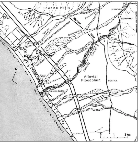
The study by Ozaner (1995) determined the old courses of the Deli Çay (stream) (Figure 6). The former course of the Deli flowed just south of Kinet Höyük
15 Issos as ancient Kinet had a docking place or mooring with Pinaros river (the ancient Deli Çay)
16
then fell into the sea until the last quarter of the first millennium BC (Ozaner, 1995: 516-518). The estuary of the river or stream most likely acted as a river port during the 2nd millennium BC (Gates, 2008: 292). From this date onwards, the Deli reached the sea 2 km south of Kinet along its former course (Ozaner, 1995: 517). Later, presumably in Ottoman times, the river changed its second course farther southwest, and flowed into the sea another 500 m. south of the second course (Ozaner, 1995: 518-519).
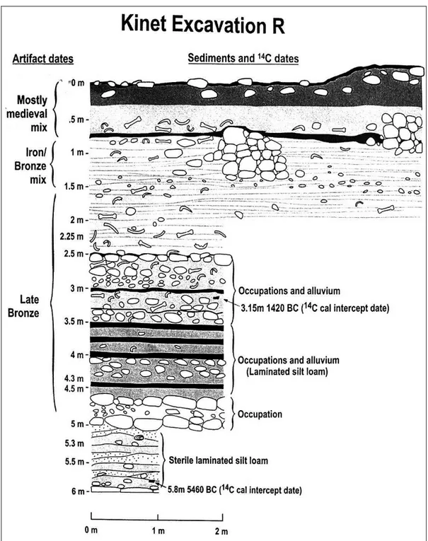
In addition, a geomorphological sounding (Operation “R”) in a field 100 m. northwest of the mound produced significant evidence for a LB harbor town or port installations beneath the alluvium (Gates, 2002: 55-56; 2003a: 289-290; Beach and Luzzadder-Beach, 2008: 422). LBA in situ occupation and artifacts were determined between depths of 0.5 m. to nearly 4.8 m. (Beach and Luzzadder-Beach, 2008: 422). At 3.5 m. depth, materials are dated to LBA, supported by radiocarbon dates 1680-1130 BC (intercept date 1420 BC 14C) (Figure 7) (Gates, 2002: 56; Beach and Luzzadder-Beach, 2008: 422-423, fig. 5).The artifacts from these deposits include fragments of imported Cypriot and Canaanite potteries (Gates, 2002: 56). It is possible that Kinet harbor settlement of the LBA or maybe a warehouse was located northwest of the mound, on the sea coast (Gates, 2003a: 289-290).
Furthermore, geomorphological studies suggest that aggradation reached the peak around Kinet Höyük in the Hellenistic to Late Roman period when the town was abandoned (Beach and Luzzadder-Beach, 2008: 425-427).
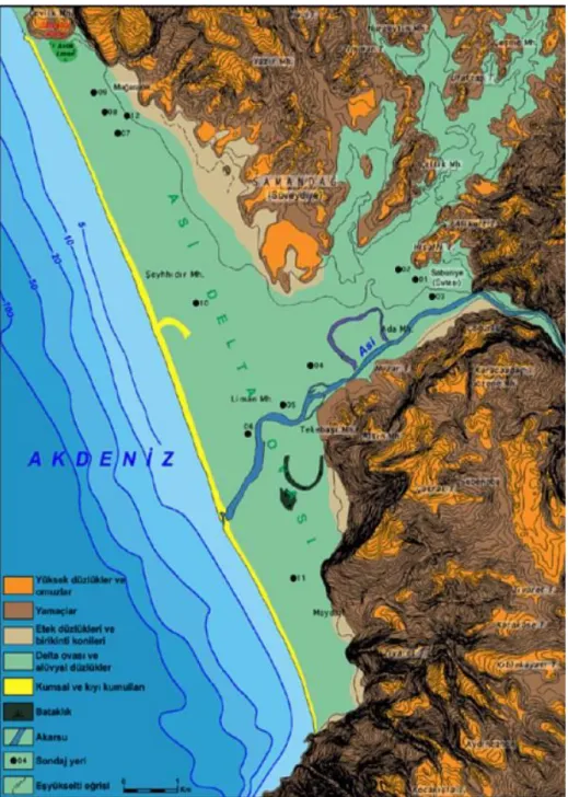
17 2.3.3 Sabuniye Höyük
Sabuniye which is ca. 5.3 km inland from the sea now is situated on the west of the Amuq where the river Asi which closes its south side reaches the delta plain (Pamir and Nishiyama, 2002: 310; Pamir, 2005: 70-71). Geomorphological studies around the mound of Sabuniye and the delta plain were carried out by E. Öner and L. Uncu within “the Asi Delta Survey”
west of the Amuq in 2000 and 2002 (Pamir, 2005: 72; Öner, 2008: 2). According to ceramic findings associated with geomorphological stratigraphy, the site could be occupied during the MBA and LBA (Öner, 2008: 7).
Core drillings (to a depth of 15 m.) were made at several points west and south of Sabuniye, along the river and the delta plain (Figure 8) (Pamir, 2005: 72; Öner, 2008: 6-7). Between 7000 and 5000 BP, the sea inserted itself into inner parts of the delta, between Al Mina and the ridge of Hisallı hill; however, the coastline never reached as far as Sabuniye (Öner, 2008: 7, 10). Sabuniye was therefore not a coastline city in the second millennium BC, but situated in a wetland area created by the river and the sea (Pamir and Nishiyama, 2002: 312; Pamir, 2005: 72; Öner, 2008: 7-8). Sabuniye was, however, closer to the mouth of the Asi than today (Öner, 2008: 10).
In this chapter, the background of the harbors and their settlements was addressed by interdisciplinary studies. Geomorphological studies confirmed that Kinet Höyük had two harbors and Sabuniye might have been used as an inland harbor, whereas, historical sources on Tarsus’s harbor and the Tarsus river do not match with geomorphological studies. These studies also indicate that rivers and their estuaries should be considered for the Bronze Age.
18
CHAPTER 3
ARCHAEOLOGICAL EVIDENCE FOR HARBOR
SETTLEMENT PATTERNS
In this chapter I will give some specific archaeological evidence or components for harbor settlements by discussing Levantine harbor settlement patterns. I will discuss the archaeological evidence in three categories which are recognized as landscape, artifacts and architecture.
3.1 The Landscape as Evidence for Harbor Settlements
In the second millennium BC, sea port and river harbor or both of them were in use. On the one hand, natural harbors, which are located on a headland, natural cove, and lagoons, acted as seaside harbors and, on the other hand, river mouths or estuaries were used as harbors, sometimes with some modifications (Blue, 1997: 31-32). Artificial harbors, which were entirely constructed, do not occur until the first half of the first millennium BC (Vann, 1997: 319; Marriner and Morhange, 2007: 146). It can be said that semi-artificial river harbors were used, particularly along the eastern Mediterranean coasts, since some man-made adjustments will be seen below.
19
River harbors have more advantages than sea ports. Especially, it is sometimes difficult to access the interior by inland road, whereas river harbors simplify the delivery of goods. In addition, the mouth of rivers provided safer anchorages for boats to approach and dock than sea ports, which were exposed to winds and sea waves. The Levantine coast was well furnished with river harbors where settlements were set at river mouths and a bit inland on the same riverbanks (Figure 9) (Raban, 1985: 14): as a typical example, on the Nahal (river) Alexander16, Tell Mikhmoreth is at the estuary of the river, while Tell Ifshar (Tell Hefer) is situated ca. 5 km upstream of the navigable river, and can be described as an inland harbor settlement (Raban, 1985: 17; Chernoff and Paley, 1998: 399; Taffet, 2001: 130). River harbors in the Levant can be used as a model to identify harbor settlements in Cilicia and the Amuq plain. Most likely, inhabitants in Cilicia and the Amuq Plain, which were enclosed by mountain ranges like the Levant, used estuaries of navigable rivers as harbors.
In Mesopotamia, however, there are many indications that Bronze Age harbors were not entirely natural, but that favorable locations were improved in various ways to make the harbor more suitable against possible perilous natural and man-made factors. In Mesopotamia and Egypt, river harbors were used in a different configuration. Levantine harbors were directly on rivers; whereas harbors in Mesopotamia and Egypt were on canals, which were dug to supply water for irrigation in the arid region (Postgate, 1992: 174, 179). They also facilitated river transport as in ancient Egypt (Hassan, 1997: 52, 54, 62; Wells, 2004: 24). The Old
16 The river was being used for transportation of crops until the 19th century AD and at least small
20
Babylonian urban site of Mashkan-shapir (Tell Abu Duwari) illustrates river harbors for southern Mesopotamia (Stone and Zimansky, 1992; 2004). The city, which was located between the ancient Tigris and Euphrates rivers, was divided by digging water channels, two of which were major canals (Stone and Zimansky, 2004: 327). The site had at least two river harbors where the large canals crossed with smaller ones: the east and the west harbors (Stone and Zimansky, 2004: 328). In Egypt, navigational networks were excavated in the Nile Delta to connect the Nile to the city of Giza in the MBA (Raban, 1991: 138; Marriner and Morhange, 2007: 158). Another MB site with modified harbors is Tell el Dab’a17, on the bank of the Pelusiac branch of the Nile. It functioned as an inland harbor settlement via a navigational channel which reached the sea (Bietak, 1996: 3, 20).
This distinction between river harbors in the Levant, Mesopotamia and Egypt could be rooted in the regime of rivers. The wide or long rivers in Mesopotamia (the Tigris and Euphrates) and the Nile in Egypt were subject to natural and catastrophic floods or overflowing when the volume of water increased annually. Therefore, sites were situated away from rivers and the water was brought into sites by canals to avoid floods (Postgate, 1992: 174, 177). However, rivers in the Levant, Cilicia and the Amuq offered safer conditions for habitation, since the rivers were shorter or smaller and flow in deep valleys (such as the Göksu and the Asi). In addition, swamp areas in Cilicia could absorb the water from overflowing. Therefore, areas near rivers were settled and estuaries could have been used as harbors.
17 Tell el Dab’a had more than one harbor because the water level of the Nile varied in a year
(Tronchere et al., 2008: 338). It is highly likely the site had three harbors: first in the middle of the town, second was to the south, third at the north of the town (Forstner-Müller, 2009: 12). The site followed the Levantine harbor patterns thanks to immigration from the Levant in the Hyksos period (see Bietak, 1996).
21
The modifications, some of which could be documented in the Levant, involved some common measures to make harbors suitable for boats, instead of the type of river harbor known in Mesopotamia and Egypt. A barrier or a dam could be built upriver to reduce silting, which threatens to close off the river outlet, or a navigational channel was dug to transfer the river opening to a more suitable area (Raban, 1988: 200; 1991: 137; 1995: 144; Taffet, 2001: 128). The channel enables the docking basin of harbors to join the sea (Frost, 1995: 6; Raban, 1995: 145). These patterns are observed along the eastern Mediterranean coast at a number of Middle and Late Bronze sites such as MB Tell Akhziv, Tell Misrefot Yam, Tell Mikhmoreth and Tel Poleg in Israel, and a lagoonal harbor of Malia in Crete (Raban, 1985: 19; 1991: 137, 139-140; Taffet, 2001: 128, 130). Modifications like these, involving a channel and a stone quay18, are also recognized at Sirkeli (explained in the section 5.2.6 of Chapter 5) in Cilicia (Novák and Kozal, 2011: 44). Other types of modifications, such as excavating harbors to make them larger, and stabilizing their banks with masonry, are not found in Cilicia and the Amuq. It seems that these measures to keep estuaries free of silting were not permanent against geomorphological changes (Raban, 1985: 12, 19). However, the coastline saw a more rapid change in the first millennium BC than in the second millennium, and geomorphologic changes affected the coastline only slowly.
Finally, in the eastern Mediterranean, many harbor settlements used more than one harbor, combining a natural anchorage or sea port on the coast with another
18 Middle Egyptian literary tales refer to quays as landing places where boats were approached and
were connected a rope (Simpson, 1973:50, 59, 70); A text from Ugarit refers to a damaged ship because of crashing into the quay of Ura (Otten, (1975) as cited in Dinçol et al., 2000: 10). Bronze Age quays are also known from Egyptian pictorial evidence which depicted ships on quays of the Nile harbors (Höckmann, 2006: 312, fig. 1.7-8, 314, fig. 2.1).
22
one inside the river estuary. The pattern can be exemplified by Tell Tweini in Syria (Al-Maqdissi et al., 2007: 6) and Kinet Höyük in Cilicia (Ozaner, 1995: 516; Gates, 1999b: 305). Tell Abu-Hawam also had three ports: a natural bay, river mouth and lagoon (Taffet, 2001: 129). Sidon had a number of harbors: two natural bays, two sea harbors (one of which was the island), and one river harbor (Carayon et al., 2011/12: 434, 437, 439-449). It is known that lagoon formations also were used as harbors in the second millennium BC. Tell Dor had two lagoons as its MB harbors in addition to a natural anchorage (Raban, 1995: 145; Taffet, 2001: 130). It is likely that LB Ras Shamra (Ugarit) also exploited a number of harbors (Astour, 1970: 114-116): Minet el-Beidha and Ras Ibn Hani as sea ports are determined (see below, the section 5.5 of Chapter 5). It is possible that using more than one harbor would have been associated with natural conditions (wind conditions) as well as for special purposes (trans-shipment) (Raban, 1995: 139). Wind and weather conditions might have determined which harbor to use or harbors of a site would have served different purposes, river harbors being more convenient to transport goods to the interior.
3.2 Artifacts as Evidence for Harbor Settlements
Artifacts which are indicators of cultural interactions by boat also provide indirect evidence for harbor settlements. In this section, these artifacts, ranging from pottery, seals, shell and raw materials will be limited to types which are specific for harbor settlements.
23 3.2.1 Ceramics
Some characteristic types of pottery, and their contents, circulated along the eastern Mediterranean as koine by boat. These major types are Cypriot pottery19, Mycenaean pottery from the Greek mainland, and “Canaanite” jars from Levantine regions. These ceramics can roughly be divided into two categories: ceramics as commercial containers or for storage and ceramics as commercial goods (Matthӓus, 2006: 345). In this part, ceramics as containers for maritime trade will primarily be considered. Most of them were initially produced as packaging to carry organic goods (Sherratt and Sherratt, 1991: 362).
A prevalent and widely distributed type is the “Canaanite” jar20or amphora, designed as commercial container for the MB and LBA maritime transport (Figure 10) (Sherratt and Sherratt, 1991: 364). This jar type which was produced in various areas in the Levant or land of Canaan21 was found in the LBA Uluburun shipwreck
and harbor settlements in the eastern Mediterranean (Yalçın et al., 2006: 583; Pedrazzi, 2010: 53; Ownby and Smith, 2011). It was produced in a standardized shape22 and capacity (10-14 or seldom 18-22 litres) (Pedrazzi, 2010: 53-54). Over a hundred “Canaanite” jars from the Uluburun shipwreck prove that these jars carried Pistacia (terebinth) resin and liquid (oil and wine) as well as olives in a boat as
19 Widely distributed types White Slip Ware or “milk bowl”, Base Ring ware, White Shaved Ware,
Monochrome Ware (and possibly Red Lustrous Wheel Made Ware).
20 The name of “Canaanite” for this jar type derives from in the research of V. Grace and R. Amiran
(Pedrazzi, 2010: 53). The type was used as containers from the late MBA (Ownby and Smith, 2011: 279).
21 This jar also locally produced in some LBA Cypriot sites (Ownby and Smith, 2011: 277).
22 Its conical body narrows to a pointed base from the shoulder, which is the widest part and has two
handles (Yalçın et al., 2006: 583; Pedrazzi, 2010: 53). However, Pedrazzi’s (2010) analysis shows that this standardized shape have been morphologically changed in Syrian coast, Cyprus and Southern Anatolia between the end of LBA and the beginning of the Iron Age: its conical body transformed “slightly carinated shoulder and rounded bellied” and its carrying capacity also was large (20-40 litres) (Pedrazzi, 2010: 54).
24
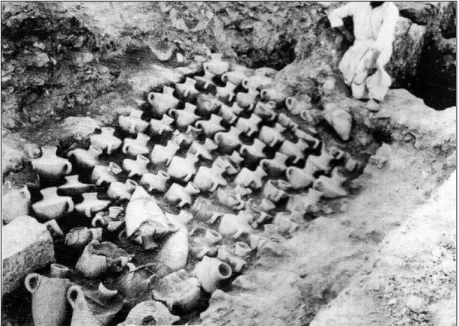
containers (Yalçın, 2006: 23). These jars were not only used as containers along the sea voyage, but also for the storage of organic goods in Levantine warehouses until their distribution or departure. The best illustration is, the “Canaanite” jars stored in a LBA warehouse of Minet el-Beidha (Figure 11) (Sauvage, 2007: 618-619). “Canaanite” jars, which could be carried by boat, also were imported from Syria-Palestine to Egyptian river harbors like Tell el Dab’a23 and Memphis (Bietak, 1991; Ownby and Smith, 2011: 279). They are an indication of transfer from sea to river transport. “Canaanite” jars in Tell Tweini, which are similar to the jars of Ugarit and Tarsus in Cilicia, (Vansteenhuyse, 2008: 111), attest to maritime activity between sites in the same route. “Canaanite” jars are also known from Kinet Höyük in Cilicia (Gates, 1999b: 307).
Another common type of container was the pithos, a big ceramic vessel (Figure 12). These containers were designed as a safe package for land storage as well as in a boat and during transshipment24 (Artzy, 1994: 138; Pulak, 2006: 81). At least three out of ten Cypriot pithoi from the Uluburun shipwreck were packed with Cypriot ware (Hirschfeld, 2006: 108). These containers from the shipwreck give significant information about how breakable goods were packaged and transported via maritime trade (Hirschfeld, 2006:109). This information can also explain how considerable amounts of ceramics from overseas were transported to inland centers, such as Cypriot ceramics to Tell el Dab’a (Bietak, 1991) and at Tell Atchana in the
23About two million “Canaanite” jars were found as containers however, some of them used at
funerary context at this site in the MBA (Bietak, 1991: 41; 1996: 20).Tell el Dab’a (MBA) also presents other ceramics mostly jars, some of them originated in the Levant, Ugarit, the Amuq or Cilicia as well as Cyprus, and the Aegean (Bietak, 1991; Marcus, 2007: 160, 162-163; Marcus et al., 2008: 236).
24 Egyptian pictorial evidence (on the representation of Theban tomb of Kenamon) also supports the
25
Amuq (Bergoffen, 2005) (see below, the section 5.4.1 of Chapter 5). Valuable raw materials were also put into pithoi. These pithoi were attested at other harbor settlements like Ugarit, Tel Nami, Tell Abu Hawam25 and Tell Tweini, as local imitations of Cypriot types (Artzy, 1994: 138; 2006: 52; Vansteenhuyse, 2008: 110).
In addition, some small or large closed forms such as juglets, bottles, jugs and jars were used as containers for liquid organic materials, whether they were “bottled at source” (Sherratt and Sherratt, 1991: 362-363) or not (Maguire, 1995: 54). In other words, a producer region might itself use ceramic packaging as containers or its ceramic containers might have been packed with foreign goods.
Moreover, pottery26 was also widely imported to the eastern Mediterranean as commercial goods because of functional demand and aesthetic value (Matthӓus, 2006: 346) alongside its contents. The Uluburun shipwreck proves that Cypriot finewares or table ware (mainly bowls and jugs) were imported for their own sake in ceramic containers as commercial goods by boats (Figure 13) (Hirschfeld, 2006: 105). Whether these ceramics were used as containers in receiver regions or in their own right, they reflect strong interregional or overseas interaction by boat.
3.2.2 Local Trends in Ceramic Styles
Local ceramics also can be used as an index for harbor settlements (Gates, 1999b: 305). In other words, occupants in harbor settlements reflect cultural mix through the decoration and form of their local ceramics. Foreign ceramics were
25 In the Carmel coast of Israel, Tel Abu Hawam on the Qishon river, Tel Akko, is located north of the
Na’aman river and Tell Nami, is located near the Me’arot river, are also defined as river harbor settlements where ceramics and metal industry maintained (Artzy, 1994: 123; 2006:46, 49-50). The coast also took place at the sailing routes of boats in that time (Artzy, 2006: 59).
26 Some Cypriot ceramics (ongoing from MBA and LBA) and Mycenaean ceramics (especially from
26
locally imitated; the production was made in different shapes from the original ones thanks to the cosmopolitan nature of overseas interaction. For example, some Cypriot and Palestinian ceramic practices were adapted at Tell el Dab’a (Figure 14) (Bietak, 1996: 59). MBA local ceramics in Tell Ifshar were seen in north Syrian forms with local motifs (Marcus et al., 2008: 236-237). The LBA local ceramics in Tell Abu Hawam27 were also similar to Cypriot fabrics (Artzy, 2006: 54-55). A group of local Syrian ceramics in Alalakh essentially derived from a MBA Cypriot style (Maguire, 1995: 55).
3.2.3 Shipwrecks and Their Cargos
Apart from ceramics, other archaeological materials which were being carried by boats between harbors, give insight into harbor settlements. These finds were found at eastern Mediterranean harbor settlements and at the LBA shipwrecks28 of Cape Gelidonya (Bass, 1967) and Uluburun (Yalçın et al., 2006) as cargos.
Shipwrecks themselves are archaeological indications of the presence of harbor settlements as well as overseas interaction. They also illustrate the ship-building industry which would have been supplied with timber from forests in the Levant, Cilicia and the Amuq (see below, Chapter 4). Shipwrecks also can answer questions such as how materials were being transported across the eastern
27 Anatolian, Aegean and Egyptian pottery was also found at Tell Abu Hawam (Artzy, 2006: 52, 55). 28
Until now no MBA shipwreck has been discovered, however, a written source of early 12th Dynasty of Middle Kingdom (the Mit Rahina inscription) shows that cargos, some of which are cedar, resin, metals, ivory, building stones and people, were carried from the northern Levant (Lebanon, Syria and probably Cilicia) to Egypt by more than one ships (Marcus, 2007: 132-157,173-176).
27
Mediterranean. The transport by boat permitted tons of goods to reach harbors. The cargo of the Uluburun29 well represents the importance of harbor settlements.
A first material is copper in “oxhide” ingots, found at terrestrial sites30 as well (Gale and Stos-Gale, 2006: 120; Pulak, 2006: 64-65). In addition, analyses of some lead and silver items from the Uluburun and Ras Ibn Hani and Mochlos in Crete correspond with mineral reserves in the Taurus Mountains (Soles, 2005: 434-435; Gale and Stos-Gale, 2006: 127, 131-132). It means that the Cilician harbors must have been used to transport metals by boat (Soles, 2005: 435-437).
In addition, eastern Mediterranean objects, which were produced by the meeting of cultures and ideas, emphasize the cosmopolitan character of harbor settlements. For example, Levantine workmanship and Egyptian iconography were combined on jewelry, one example of which is known from Uluburun: a gold pendant with a representation of the goddess Astarte (Figure 15) (Pulak, 2006: 68; Yalçın et al., 2006: 597), a type known from the MBA southern Palestine (Tell el Ajjul) (Tubb, 1998: 65), was also found at Minet el Beidha (Yon, 2006: 166, fig. 58a).
29 The wreck includes raw (metal and glass in form of ingots, unworked hippo and elephant ivory,
organic bulk), manufactured and luxury objects (jewelries made from gold, silver, bronze, precious stones and faience and glass by both local and foreign interactions; bronze weapons and tools; seals, scarabs, weights) and materials for shipboard use and shipbuilding (lamps, and stone anchors, timber) as well (Bass, 1986; Yalçın et al., 2006).
30 According to lead isotope analyses of these ingots from shipwrecks, copper ores in the island of
Cyprus was responsible for them (Gale and Stos-Gale, 2006: 121, 124,127). These were distributed to Germany, France, Sardinia, Sicily, Greece, Crete, Bulgaria, central Anatolia, Syria, the Nile delta and Iraq (Gale and Stos-Gale, 2006: 120; Müller-Karpe, 2006: 493; Pulak, 2006: 63-64). Oxhide ingots in Mochlos, Crete also match Cypriot copper ores (Soles, 2005: 435; Gale and Stos-Gale, 2006: 127). Besides, one round copper ingot in Kuşaklı/Sarissa, central Anatolia corresponds to Cypriot ores (Müller-Karpe, 2006: 493).
28 3.2.4 Boats
Thirdly, depictions of boats, which are mostly known from the Aegean and Egypt31 (Höckmann, 2006: 311-312, fig.1, 314, fig. 2, 317-318, 320, fig. 5-6, 321), can be attributed as archaeological evidence for Levantine harbor settlement patterns. Boats are illustrated on seals from Tell el Dab’a (Porada, (1984) as cited in Marcus (2007: 154) and Ugarit (Figure 16, 17) (Amiet, 1992: 106, fig.42.232; Höckmann, 2006: 314, fig. 2.6, 316) and on a Canaanite jar from Tell Tweini (Figure 18) (Bretschneider and Lerberghe, 2008b: 33, 38, fig. 3.39); incised on an altar at Tell Akko (Artzy, 2006: 50), and carved into rocks on the Carmel Mount Ridge surrounding of Tell Nami (Artzy, 1994: 138). These depictions show that Levantine coastal settlements were engaged as harbors in sea-oriented activities.
Stone anchors are another class of artifacts referring to boats. However, Middle and Late Bronze anchors are mainly known from cultic contexts as votive objects from Ugarit and its harbor Minet el Beidha, Cyprus (Kition and Hala Sultan Tekke), and Crete (Malia, Kommos) (Wachsmann, 1998: 259, 273, 279; Ward and Zazzaro, 2010: 40). Sea activity was thus well integrated into the lifestyle of the harbor settlement.
3.2.5 Marine Industries
Crushed murex shell is an archaeological evidence for dye industry32. The industry required experts and the proximity of the sea (Ruscillo, 2005: 100,
31
A notable example which is known from the tomb of Kenamon at Thebes (14th century BC) shows that Syrian ships approached an Egyptian river harbor and porters carried loads like finds from the Uluburun (Bass, 1986: 293;Pulak, 1998: 214-215; Höckmann, 2006: 314, fig.2.1).
32 The earliest purpled-dye industry may be derived from the Aegean; especially Crete (MBA),
29
104). By the LBA, it was exploited throughout the Levantine harbor settlements (such as Minet el-Beidha33, Tell Akko and Tell Abu Hawam) and Cilicia (Kinet Höyük) (Gates, 1999a: 263; 1999b: 308; Artzy, 2006: 55; Reese, 2010: 120-121, 124). The Uluburun boat34 also carried thousands of Murex opercula, as raw material for the manufacture of incense, which could have been defined as another by-product of the Murex dye industry (Pulak, 2006: 74-75).
3.3 Architectural Features Specific to Harbors
Harbor settlements combined different traditions through external interaction. In the MB and LBA, they participated fully in the urban development of the eastern Mediterranean region (Raban, 1985: 14; 1995: 143). In a general schema, architectural spaces and elements in these harbor settlements were coordinated with the requirements of the site. Building complexes include storerooms, living spaces, workspaces, and a system to supply water. Like the inland settlements, they were protected by ramparts and fortification walls which were strengthened by towers and city gates.
The one architectural structure specific to the harbors is the warehouse, which could store goods in containers (ceramics or sacks) for public or commercial purpose, whether for local consumption or waiting for transshipping (Sauvage, 2007: 621-623). Such a warehouse is well illustrated in the LBA seaport of Ugarit at Minet el-Beidha (Figure 11). It is possible that the warehouse consisted of more than one room, and was arranged as a long building (Sauvage, 2007: 619-620). Rooms in the
33
Ugaritic texts refer to “blue purple wool” and “red blue purple wool” which were shipped from Ugarit (Heltzer, 1999: 446-447).
34 It is not known that some “Canaanite” jars from the wreck include some residues of blue, red textile
30
warehouses must have been arranged according to the goods for which they were designed. For instance, Sauvage stated that the dimension of a room of the warehouse, which when excavated contained 80 two-handled jars, could be ca. 3.20 m x 4 m (Sauvage, 2007:619-620)35. Clearer examples for warehouses are known from other sites such as in Crete at Knossos, Malia and Mochlos and at Kalavassos Ayios on Cyprus (Sauvage, 2007: 621). Warehouses in these sites indicate that a warehouse consisted of more than one adjacent gallery, to form a long building (Sauvage, 2007: 621). It is likely that buildings intended as warehouses were built along the riversides (Blackmann, 1982: 92) as installations to store goods at river harbors.
Another specific architectural structure is the shipshed, whose function is to store ships (Shaw, 2006: 124). Kommos, a seaport town in south Crete, had a similar LB construction with six adjacent galleries (Figure 19) (Shaw, 2006: 124). The structure, whose one room was ca. 5.60 m. wide (Shaw, 2006: 124; Sauvage, 2007: 621), was identified by Shaw as a shipshed rather than a warehouse for goods, since its open side faced to the sea (Shaw, 1990: 426-427; 2006:124-125). The shipshed functioned to protect boats from natural threat (strong winds and waves) particularly in winter seasons (Shaw, 2006: 39). The shipshed or a building with similar function is not yet known from other sea ports36 or river harbors.
35 The dimension can give at least, an idea to illustrate a storeroom capacity in LB harbors. If a room
in this size could include 80 jars (Canaanite jars were not small), a warehouse with more than one room could have housed a considerable amount of goods and thus, a warehouse could define a main building for harbor settlements (Sauvage, 2007: 619-620).
36 A textual reference from Ugarit mentions that ships were stored “at royal stores” (Heltzer, 1999:
31
CHAPTER 4
THE IMPORTANCE OF RIVERS AND RIVER TRANSPORT
The importance of the river for the theme of this thesis is derived from the relationship between people and rivers. First of all, rivers provide a water source and fertile and flat lands for human livelihood. Therefore, the location of the river could define a pattern for the distribution of its settlements. Second, rivers offer inland routes, especially towards the highlands, for the movement of people and transport of goods. Thirdly, people modify river beds to build systems for water supply and maintenance such as irrigation channels and dams, especially in drier areas (Wilkinson, 2003: 45). Finally, and relevant for this thesis, rivers define a pattern for the distribution of harbor settlements in the second millennium BC, since people used estuaries as harbors by modifying them to some extent (Raban, 1985; 1991).
According to geomorphological studies in deltas, and to ancient authors, it is likely that estuarine areas presented more appropriate circumstances for river harbor and transport in the second millennium BC than in later times. Aegean coastal changes of the fifth century BC were recorded by ancient authors (Horden and Purcell, 2000: 313-314). The Cilician case was recorded by Strabo who noted rapid