NONLINEAR MIXED INTEGER
PROGRAMMING MODELS AND
ALGORITHMS FOR FAIR AND EFFICIENT
LARGE SCALE EVACUATION PLANNING
a dissertation submitted to
the graduate school of engineering and science
of bilkent university
in partial fulfillment of the requirements for
the degree of
doctor of philosophy
in
industrial engineering
By
Vedat Bayram
July, 2015
NONLINEAR MIXED INTEGER PROGRAMMING MODELS AND ALGORITHMS FOR FAIR AND EFFICIENT LARGE SCALE EVACUATION PLANNING
By Vedat Bayram July, 2015
We certify that we have read this dissertation and that in our opinion it is fully adequate, in scope and in quality, as a dissertation for the degree of Doctor of Philosophy.
Prof. Hande Yaman (Advisor)
Assoc. Prof. Alper S¸en
Assoc. Prof. ˙Ibrahim Akg¨un
Assoc. Prof. Bahar Yeti¸s Kara
Assist. Prof. Cem ˙Iyig¨un Approved for the Graduate School of Engineering and Science:
Prof. Levent Onural Director of the Graduate School
ABSTRACT
NONLINEAR MIXED INTEGER PROGRAMMING
MODELS AND ALGORITHMS FOR FAIR AND
EFFICIENT LARGE SCALE EVACUATION PLANNING
Vedat Bayram
Ph.D. in Industrial Engineering Advisor: Prof. Hande Yaman
July, 2015
Shelters are safe facilities that protect a population from possible damaging effects of a disaster. Traffic management during an evacuation and the decision of where to locate the shelters are of critical importance to the performance of an evacuation plan. From the evacuation management authority’s point of view, the desirable goal is to minimize the total evacuation time by computing a system optimum (SO). However, evacuees may not be willing to take long routes enforced on them by a SO solution; but they may consent to taking routes with lengths not longer than the shortest path to the nearest shelter site by more than a tolerable factor. We develop a model that optimally locates shelters and assigns evacuees to the nearest shelter sites by assigning them to shortest paths, shortest and nearest with a given degree of tolerance, so that the total evacuation time is minimized. As the travel time on a road segment is often modeled as a nonlinear function of the flow on the segment, the resulting model is a nonlinear mixed integer programming model. We develop a solution method that can handle practical size problems using second order cone programming techniques. Using our model, we investigate the trade-off between efficiency and fairness.
Disasters are uncertain events. Related studies and real-life practices show that a significant uncertainty regarding the evacuation demand and the impact of the disaster on the infrastructure exists. The second model we propose is a scenario-based two-stage stochastic evacuation planning model that optimally locates shelter sites and that assigns evacuees to shelters and paths to minimize the expected total evacuation time, under uncertainty. The model considers the uncertainty in the evacuation demand and the disruption in the road network and shelter sites. We present a case study for an impending earthquake in Istanbul, Turkey. We compare the performance of the stochastic programming solutions to solutions based on single scenarios and mean values.
iv
the stochastic problem. To the best of our knowledge, ours is the first algorithm that uses duality results for second order cone programming in a Benders de-composition setting. We solve practical size problems with up to 1000 scenarios in moderate CPU times. We investigate methods such as employing a multi-cut strategy, deriving pareto-optimal cuts, using a reduced primal subproblem and preemptive priority multiobjective program to enhance the proposed algorithm. Computational results confirm the efficiency of our algorithm.
This research is supported by TUBITAK, The Scientific and Technological Research Council of Turkey with project number 213M434.
Keywords: Disaster Management, Evacuation Traffic Management, Shelter Loca-tion, System Optimal, Constrained System Optimal, User Equilibrium, Nearest Allocation, Two-Stage Stochastic Programming, Second Order Cone Program-ming, Benders Decomposition, Pareto-optimal Cuts.
¨
OZET
AD˙IL VE ETK˙IN B ¨
UY ¨
UK ¨
OLC
¸ EKL˙I TAHL˙IYE
PLANLAMASI ˙IC
¸ ˙IN DO ˘
GRUSAL OLMAYAN KARIS
¸IK
TAMSAYILI MODELLER VE ALGOR˙ITMALAR
Vedat Bayram
End¨ustri M¨uhendisli˘gi, Doktora Tez Danı¸smanı: Prof. Hande Yaman
Temmuz, 2015
Barınaklar bir n¨ufusu bir felaketin muhtemel yıkıcı etkilerinden koruyan g¨uvenli tesislerdir. Bir tahliye esnasında trafik y¨onetimi ve barınakların nerelerde a¸cılaca˘gı tahliye planının ba¸sarısı a¸cısından ¨onemlidir. Tahliye y¨onetim birimi a¸cısından arzulanan hedef sistem eniyi yakla¸sımını kullanarak toplam tahliye zamanını en azlamaktır. Bununla birlikte, tahliye edilen insanlar, sistem eniyi yakla¸sımı tarafından kendilerini uzun bir yola atayan bir ¸c¨oz¨um¨u kabul etmekte istekli olmayabilirler; fakat tahliye edilen insanlar, en yakın barına˘ga giden en kısa yoldan ¸cok fazla uzun olmayan, belli bir tolerans sınırı i¸cinde ba¸ska bir ro-tayı kullanmayı kabul edebilirler. Tahliye edilecek n¨ufusu, belirli bir tolerans sınırı i¸cerisinde, en yakın barınak noktalarına giden en kısa yolları kullandırarak atayan ve toplam tahliye zamanını en k¨u¸c¨ukleyecek ¸sekilde barınakları en uygun noktalara yerle¸stiren bir model geli¸stiriyoruz. Bir yol kesiti ¨uzerindeki seyahat s¨uresi o yol kesiti ¨uzerindeki trafik yo˘gunlu˘gunun do˘grusal olmayan bir fonksiy-onu olarak modellendi˘ginden, ortaya ¸cıkan model do˘grusal olmayan karı¸sık tam-sayılı programlama modelidir. Ger¸cek boyutlu problemleri ikinci seviye konik programlama teknikleri kullanarak ¸c¨ozebilen bir y¨ontem ¨oneriyoruz. Modelimizi kullanarak etkinlik ve adillik kriterleri arasındaki ¨od¨unle¸simi ara¸stırıyoruz.
Felaketler belirsizlik i¸ceren olaylardır. Bu konudaki ilgili ¸calı¸smalar ve edinilen tecr¨ubeler tahliye talebi ve felaketin yol a˘gına ve altyapıya etkileri konusunda ¨
onemli belirsizli˘gin oldu˘gunu g¨ostermektedir. Onerdi˘¨ gimiz ikinci model fe-laketlerdeki belirsizli˘gi dikkate alarak tahliye edilecek n¨ufusu, barınak nokta-larına ve rotalara atayarak beklenen toplam tahliye zamanını en k¨u¸c¨ukleyecek ¸sekilde barınakları en uygun noktalara yerle¸stiren, senaryo tabanlı ve iki a¸samalı rassal bir tahliye planlama modelidir. Modelimiz tahliye talebi ile yol a˘gı ve barınaklardaki bozulma ve yıkım konusundaki belirsizli˘gi dikkate almaktadır.
vi
˙Istanbul, T¨urkiye’de beklenen bir depreme y¨onelik ¨ornek olay incelemesi sunuy-oruz. Rassal ¸c¨oz¨um¨un sonu¸clarını, sadece bir senaryoya dayanan ya da ortalama de˘gerleri dikkate alarak ¨uretilen ¸c¨oz¨umlerin sonu¸cları ile kar¸sıla¸stırıyoruz.
Ayrıca rassal problemi ¸c¨ozmek ¨uzere Benders ¸c¨oz¨umlemesine dayanan kesin ¸c¨oz¨uml¨u bir algoritma sunuyoruz. Algoritmamızın Benders ¸c¨oz¨umlemesi i¸cinde ik-inci seviye konik programlama ikillik sonu¸clarını kullanan ilk algoritma oldu˘gunu d¨u¸s¨un¨uyoruz. Ger¸cek b¨uy¨ukl¨ukteki problemleri 1000 senaryo sayısına kadar kısa s¨ure i¸cerisinde ¸c¨ozebiliyoruz. ¨Onerdi˘gimiz modelin performansını artırmak i¸cin, ¸coklu kesi stratejisi, pareto-eniyi kesiler elde etme, azaltılmı¸s birincil altprob-lem kullanma ve ¨oncelikli ¸cok ama¸clı programlama gibi y¨ontemleri ara¸stırıyoruz. Sayısal sonu¸clar algoritmamızın etkinli˘gini kanıtlıyor.
Bu tez T¨urkiye Bilimsel ve Teknolojik Ara¸stırma Kurumu (T ¨UB˙ITAK) tarafından 213M434 numaralı proje ile desteklenmektedir.
Anahtar s¨ozc¨ukler : Felaket Y¨onetimi, Tahliye Trafik Y¨onetimi, Barınak Yer Se¸cimi, Sistem Eniyi, Kısıtlı Sistem Eniyi, Kullanıcı Denge, En Yakına Atama, ˙Iki-A¸samalı Rassal Programlama, ˙Ikinci Seviye Konik Programlama, Benders C¸ ¨oz¨umlemesi, Pareto-Eniyi Kesiler.
Acknowledgement
I would like to express my sincere gratitude to a number of people, without whose support and encouragement this doctoral dissertation would not have been possible.
I would like to express the deepest appreciation to Professor Barbaros Tansel, without his support and faith in me I wouldn’t be a part of Bilkent community now. This dissertation began with his guidance and was shaped with his invalu-able ideas until we lost him unexpectedly. He had always shown the attitude and the substance of a genius: he continually and persuasively conveyed a spirit of adventure in regard to research and scholarship, and an excitement in regard to teaching. His ideas will continue to enlighten me on the way to become a good academician as he always wished and expected.
This dissertation was supervised by Prof. Hande Yaman. I would like to express my special appreciation and thanks to Prof. Yaman, for she has been a tremendous mentor for me. I would like to thank her for encouraging my research, her advice on both research as well as on my career have been priceless.
I am deeply grateful to the members of this dissertation committee; Assoc. Prof. Alper S¸en, Assoc. Prof. ˙Ibrahim Akg¨un, Assoc. Prof. Bahar Yeti¸s Kara and Assist. Prof. Cem ˙Iyig¨un for devoting their valuable time to read and review this dissertation manuscript. Their suggestions, comments and recommendations are of great value to the quality of this dissertation. Special thanks go to Assoc. Prof. Alper S¸en and Assoc. Prof. ˙Ibrahim Akg¨un for being in the dissertation progress meetings for a period of more than two years. Their comments, sug-gestions and feedback were of great importance in enriching the quality of this research.
Words cannot express how grateful I am to my mother, father, mother-in law, father-in-law, my five sisters, my nieces and nephews for all the support and of the sacrifices that they’ve made on my behalf. Their prayer for me was what sustained me thus far.
A special thanks to my wife. I would like express appreciation to my beloved wife Sibel who was always my support in the moments when there was no one to answer my queries. Without her endless support, encouragement and patience
viii
throughout this endeavor since our marriage, this would not be possible.
I acknowledge that this research is supported by TUBITAK, The Scientific and Technological Research Council of Turkey with project number 213M434.
Contents
1 Introduction 1
1.1 Aim of the Dissertation . . . 3
1.2 Methodology . . . 4
1.3 Scope of the Dissertation . . . 8
2 Literature Review 10 2.1 Disaster Management Literature . . . 10
2.2 Facility Location Literature . . . 13
2.2.1 The p-Median Problem . . . 14
2.2.2 The p-Center Problem . . . 15
2.2.3 Covering Problems . . . 16
2.3 Literature on Facility Location for Disasters . . . 17
2.4 Traffic Assignment Models . . . 19
2.5 Literature on Evacuation Planning . . . 22
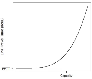
2.6 Travel Time Modeling . . . 28
2.7 Second Order Cone Programming . . . 31
3 Compromising System and User Interests in Shelter Location and Evacuation Planning 34 3.1 Our Contribution . . . 37
3.2 Models . . . 37
3.2.1 Problem Formulation under CSO Traffic Assignment Model 37 3.2.2 Formulation for the SO Traffic Assignment Model . . . 40
3.2.3 Second Order Cone Programming Approach . . . 41
CONTENTS x
3.3.1 Instances . . . 42
3.3.2 Computational Performance . . . 44
3.3.3 The Impact of the Number and Locations of Shelters on the Total Evacuation Time . . . 45
3.3.4 Efficiency and Fairness . . . 49
3.3.5 Capacitated Shelters . . . 58
3.4 Conclusions . . . 60
4 A Stochastic Programming Approach for Shelter Location and Evacuation Planning 62 4.1 Uncertainty in Facility Location . . . 63
4.2 Uncertainty in Evacuation Planning . . . 64
4.3 Our Contribution . . . 66
4.4 Problem Description and Model Formulation . . . 67
4.5 An Illustrative Case Study: Istanbul Earthquake . . . 70
4.5.1 Scenarios . . . 71
4.5.2 Effect of the Number of Shelters and Tolerance Level . . . 75
4.5.3 Effect of the Number Scenarios . . . 77
4.5.4 Effect of β . . . 78
4.5.5 Quality of Stochastic Programming Solutions . . . 82
4.5.6 Capacitated Shelters . . . 91
4.6 Conclusion . . . 96
5 Shelter Location and Evacuation Route Assignment under Un-certainty: A Benders Decomposition Approach 97 5.1 Solution Methodologies . . . 98
5.2 Our Contribution . . . 100
5.3 Benders Decomposition Approach . . . 100
5.4 Improving the Performance of the BD Algorithm . . . 108
5.4.1 Multicut Strategy . . . 108
5.4.2 Implementing a Callback Routine . . . 109
5.4.3 Defining Strong (Pareto-Optimal) Cuts . . . 111
5.5 Computational Study . . . 118
CONTENTS xi
List of Figures
2.1 Framework for Disaster Operations and Associated Facilities and Flows [1] . . . 11 2.2 A Typical Link Performance Function . . . 29 3.1 Sioux Falls 1: Allocation of Demand Nodes when p = 4 and p = 9 48 3.2 The Effect of p and the Level of Tolerance on the Total Evacuation
Time, Sioux Falls 1 and 2 . . . 49 3.3 The Effect of Level of Tolerance on Maximum Latency and the
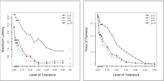
Tradeoff between Level of Tolerance and Price of Fairness, P-median1 . . . 52 3.4 The Effect of Level of Tolerance on Maximum Latency and the
Tradeoff between Level of Tolerance and Price of Fairness, Istanbul Anatolian . . . 55 3.5 The Effect of the Level of Tolerance on Percentage Evacuated by
a Given Time, Istanbul . . . 56 3.6 Normal Unfairness Distributions with respect to Paths and
Shel-ters for Various Tolerance Levels, Istanbul Anatolian . . . 57 3.7 The Effect of the Level of Tolerance on Percentage Evacuated by
a given time with Capacitated Shelters, Istanbul Anatolian . . . . 60 4.1 Possible Scenarios for a Pending Istanbul Earthquake [2] . . . 72 4.2 Peak Ground Acceleration Distributions for Scenarios [2] . . . 73 4.3 Istanbul European and Anatolian Road Networks, Potential
Shel-ter Sites and Demand Points . . . 74 4.4 The Percentage of Evacuees Reaching Safety across Time for
LIST OF FIGURES xiii
5.1 Classical Benders Decomposition Algorithm . . . 110 5.2 Benders Decomposition Algorithm with Callback Routine, [3] . . . 113 5.3 Iteration vs. UB & LB for Istanbul Anatolian Network, #Scen =
List of Tables
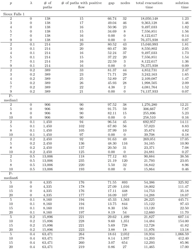
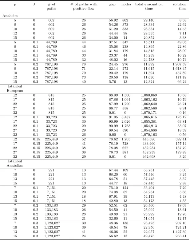
3.1 Specifics of the Instances Used in the Computational Study . . . . 44
3.2 Computational Performance I . . . 46
3.3 Computational Performance II . . . 47
3.4 Efficiency and Fairness I . . . 53
3.5 Efficiency and Fairness II . . . 54
3.6 Comparison of SO, CSO and UE Solutions for Istanbul Anatolian Network . . . 57
3.7 Efficiency and Fairness with Capacitated Shelters . . . 59
4.1 Istanbul European Instances . . . 76
4.2 Istanbul Anatolian Instances . . . 76
4.3 Results for the Istanbul European and Anatolian Instances . . . . 77
4.4 Performance of the Model with respect to Number of Scenarios Used, Istanbul European . . . 78
4.5 Performance of the Model with respect to Number of Scenarios Used, Istanbul Anatolian . . . 79
4.6 Performance of the Model with respect to β, Istanbul European . 80 4.7 Performance of the Model with respect to β, Istanbul Anatolian . 81 4.8 Total Evacuation Times . . . 84
4.9 WSS, EVPI, VSS . . . 85
4.10 Regrets . . . 86
4.11 Total Evacuation Time for Various Levels of Tolerance for Scenario 10 . . . 88
4.12 Maximum Latency for Various Levels of Tolerance for Scenario 10, Istanbul Anatolian . . . 90
LIST OF TABLES xv
4.13 Results for the Istanbul European and Anatolian Instances when
Shelters are Capacitated . . . 92
4.14 Total Evacuation Times . . . 93
4.15 WSS, EVPI, VSS for the Capacitated Shelters Case . . . 94
4.16 Regrets when Shelters are Capacitated . . . 95
5.1 Specifics of the Instances Used in the Computational Study . . . . 121
5.2 Comparison of Different Algorithms w.r.t. Computational Effec-tiveness, Istanbul Anatolian Instances . . . 123
5.3 Comparison of Different Algorithms w.r.t. Computational Effec-tiveness, Istanbul European Instances . . . 126
Chapter 1
Introduction
Natural or man-made disasters such as hurricanes, earthquakes, floods, and ter-rorist attacks impose a serious risk on the humankind. There has been a signif-icant increase in the number of disasters over the past decades; from fewer than 50 disasters per year reported in 1950 to more than 400 disasters in 2010 [4]. Consequently, the number of people affected and the economic damages caused by disasters increased. The 2004 Indian Ocean tsunami killed more than 225,000 people and dislocated millions of them in countries spread around the Ocean’s rim from Kenya to Indonesia. The 2010 Haiti earthquake measured 7.0 magnitude on the Richter scale, caused a massive level of destruction and imposed tremen-dous operational challenges on the humanitarian agencies and governments. This resulted in a grim situation: three million affected people, 200,000 deaths, and more than one million wounded [1]. The triple disaster that hit the Tohoku re-gion of Japan on 11 March 2011 triggered a massive human displacement: more than 400,000 people evacuated their homes as a gigantic tsunami induced by a magnitude 9.0 earthquake engulfed the coastal areas, and the following nuclear accident in Fukushima released a large amount of radioactive materials into the atmosphere [5]. The significant increase in the number of disasters, and con-sequently the increase in the number of people affected by them and damages incurred illustrate the importance of an effective disaster management program.
International Federation of Red Cross and Red Crescent Societies (IFRC) [6] defines disasters as “serious disruptions of the functioning of a community through widespread losses that exceed the community’s capacity to cope with using its own resources”. IFRC classifies disasters as naturally occurring physical phenomena caused either by rapid or slow onset events which can be geophysical, hydrological, climatological, meteorological or biological and as technological or man-made hazards that are caused by humans and occur in or close to human settlements.
Various traffic management problems arise during disasters. Evacuation of the disaster region is the most predominantly used strategy to protect people threat-ened by a disaster [7]. Traffic management during an evacuation is critical [8] since people’s lives are at stake and the unusual surge in traffic demand is generally far beyond the capacity of the road network. U.S. Federal Emergency Management Agency (FEMA) reports that 45 to 75 disasters require an evacuation annually [9]. Whether it is made by the military or civil emergency management authori-ties, evacuation planning for large scale disasters such as earthquakes, hurricanes, floods, tsunamis or CBRN (Chemical, Biological, Radiological and Nuclear) con-sequences of conventional or terrorist attacks is of critical importance for disaster management. In 1999 hurricane Floyd [10], and in 2005 hurricanes Katrina and Rita [9] required millions of people to evacuate creating largest traffic jams in the U.S. history. In an interview by CNN [11] after the evacuation for Rita, the top U.S. Democrat on the Senate Homeland Security Committee of the time said “God forbid, there’s a terrorist attack of some kind on a major American city that requires evacuation without warning”, pointing out requirement for an effi-cient evacuation plan. If the evacuation is not planned and managed effectively, the surge in evacuation traffic demand can cause congestion and may leave the evacuees in harm’s way possibly resulting in further losses. Successful evacua-tion management not only saves lives but also contributes to the community’s regaining functionality in a fast and smooth way [12].
The time to evacuate a disaster region depends on the locations of shelters and on the traffic assignment. Shelters are safe places that protect a population from possible damaging effects of a disaster. They also serve as facilities where evacuees are provided food, medical care and accommodation. FEMA [13], American
Red Cross (ARC) [14], FEMA ([15], [16]) provide the basis for the design and construction of shelters against different types of disasters. Whether it is built as a new shelter or as a retrofit construction, these preparations require time and need to be done before the disaster takes place. For that reason, the decision of which shelters to open are often made before a disaster occurs. Sherali et al. [17] point out in their study that one of the greatest tasks in developing a hurricane evacuation plan is to determine where evacuees should seek shelter in order to retreat from the storm’s damaging power. In their study Liu et al. [18] emphasize that improving the local warning system will be effective only if people at risk can be evacuated to safe shelters. And secure shelters are a means to increase evacuation rates [19]. Even though the decision of where to locate the shelters from among potential alternatives is of critical importance to the performance of an evacuation plan (Sherali et al. [17], Kongsomsaksakul et al. [20], Kulshrestha et al. [21]), few evacuation models in the literature decide optimally on the number and location of shelters.
1.1
Aim of the Dissertation
The studies on evacuation planning in the literature generally disregard the de-cisions of where to locate the safe shelters and they generally assume the shelter locations as given. However, addressing these two problems -locating shelters and planning the evacuation traffic- separately may lead to suboptimal results as the shelter location decisions affect the evacuation traffic management and are critical for an efficient evacuation plan.
The studies that do consider the shelter location decisions simultaneously with evacuation traffic management, suffer from the drawback of not being realistic or implementable. In addition these studies combine the interests of the evacuees and the evacuation management authority only by means of bilevel models which are hard to solve. For that reason the solution methodologies developed for large scale evacuation problems using these models are generally not exact.
Further, the number of studies that take into consideration the uncertainty in evacuation planning is limited. Those studies that take into account uncertainty are not solved with enough number of scenarios for a realistic planning.
The aim of this dissertation is to provide a fair, efficient and a more realistic evacuation planning tool that simultaneously optimizes the shelter locations and the allocations of evacuees to shelters and to routes. The decision of where to locate the shelters is a strategic decision taken before the disaster takes place and we would like to measure the impact of shelter location decisions on routing of evacuees. Our goal is not only to combine shelter location with traffic assignment; we also aim to combine the points of views of the evacuation authority and the evacuees and hence incorporate a fairness consideration into the planning process. The methodology we develop is fair and efficient because we compromise the needs of the evacuees and the evacuation management authority. It is more realistic because, we take into consideration the real conditions in an evacuation during a disaster and the behaviors of the evacuees in such a situation. Further we take into account the uncertainty considering a large number of scenarios and provide exact solution techniques.
1.2
Methodology
In this dissertation we present a novel approach to evacuation planning and pro-pose new models and algorithms as solution methodologies. In an evacuation planning process, from the evacuation management authority’s point of view, the desirable goal is to minimize the total evacuation time by computing a system optimum (SO). However, evacuees may not be willing to take long routes enforced on them by a SO solution; but they may consent to taking routes with lengths not longer than the shortest path (shortest geographical distance, shortest free flow travel time or shortest congested time) to the nearest shelter site by more than a tolerable factor. We develop a constrained system optimal (CSO) model that optimally locates shelters and assigns evacuees to the nearest shelter sites by assigning them to shortest paths, shortest and nearest with a given degree of
tolerance λ, so that the total evacuation time is minimized.
Even though λ is a parameter that we set a priori, incorporating tolerance into the model is not trivial. We compute an initial set of paths that may be acceptable. But depending on the choice of shelters, some of these paths are in fact not acceptable. We only allow the paths that are not longer than 1 + λ times the length of a shortest path to the closest “open” shelter. Hence the actual set of acceptable paths depends on the locations of open shelters and it is not an input of the model.
We show that our model generalizes p-median facility location problem and SO and nearest allocation (NA) traffic assignment models. As the travel time on a road segment is often modeled as a nonlinear function of the flow on the segment, the resulting model is a nonlinear mixed integer programming model. We develop a solution method that can handle practical size problems using second order cone programming (SOCP) techniques. Clearly, reformulation using SOCP does not change the theoretical complexity of the problem but in practice, it enables us to solve large problems exactly without approximating the nonlinear function with linear functions. Using our model, we investigate the importance of the number and locations of shelter sites and the trade-off between efficiency and fairness. In addition, we present a sensitivity analysis by changing the level of tolerance and the number of shelters to open and make a comparison of the results of SO, user equilibrium (UE), NA and CSO approaches based on system performance and fairness. We measure the efficiency of the system by employing performance measures such as total evacuation time, percentage of evacuees reaching safety up to a specified time T , maximum latency and price of fairness.
Disasters are uncertain events; it is very difficult to anticipate the exact place, time and scale of disasters. Related studies and real-life practices show that a significant uncertainty regarding the evacuation demand and the impact of the disaster on the infrastructure exists. In modeling uncertainty, we opt for the sce-nario approach to be able to model accurately the impact of the disaster on the population and the infrastructure. If we ignore how vulnerable the road network
structure and/or the shelters are, the damage may result in an inefficient evacu-ation plan possibly resulting in chaos and panic among the evacuees and further losses. We introduce a two-stage stochastic model that decides simultaneously on the locations of shelters and the allocations of evacuees to shelters and routes under uncertainty. In this model we use a stochastic programming approach, and hence instead of planning the evacuation based on a single hazard scenario, we consider a range of hazard scenarios. To the best of our knowledge, this is the first model in the evacuation literature that considers the uncertainty in the evacuation demand, the disruption in the road network, degradation in road ca-pacities and disruption of the shelters simultaneously. We report the results of a case study for an impending earthquake in Istanbul, Turkey and show that the solution of our stochastic model leads to a significant decrease in the total evac-uation time compared to the deterministic and mean value solutions. We also analyze the impact of having capacitated shelters on performance measures.
To have a more realistic evacuation planning that considers uncertainty, we need to consider a large number of scenarios. We are not able to solve practical size problems with a large number of scenarios by using an off-the-shelf solver in reasonable CPU times or can not solve the problem at all. To overcome this, we develop exact algorithms based on Benders decomposition. As the second stage of the model is a second order cone programming problem, to the best of our knowledge, ours is the first algorithm that uses duality results for second order cone programming in a Benders decomposition setting. We solve practical size problems with up to 1000 scenarios in moderate CPU times. We investigate meth-ods such as employing a multi-cut strategy, deriving pareto-optimal cuts, using a reduced primal subproblem and preemptive priority multiobjective program to enhance the proposed algorithm. Computational results confirm the efficiency of our algorithm.
Like most evacuation planning models in the literature, and as suggested by [22], our model is not specific to a certain type of disaster. Our model can be used for different types of disasters and the special features are represented in the parameters. One can easily change the risk zone (earthquake affected zone, inundated area in a flood, area predicted to be hit by a hurricane) depending on
the type of disaster and potential shelter sites can be modified likewise. Although our model already tries to evacuate everyone to safety as soon as possible, it is easy to assign different risk values to different zones in accordance with when and with how much impact a hurricane is expected to hit, by trying to minimize the total risk evacuees incur as well as the total evacuation time. This can be done by modifying the objective function as in Han et al. [23]. In case of an earthquake, our model can be applied to a post-disaster evacuation or considering the secondary disasters that can emerge after an earthquake it can be used for a pre-disaster evacuation. Hurricanes and floods differ from earthquakes in that they have a warning time to evacuate the population before the disaster hits, with floods having shorter warning times. These are some examples where our model can both be used as a pre/post-disaster evacuation management tool for planning purposes.
Our model is different from classical location models in the sense that it also considers the routing of evacuees on acceptable paths. This is a major difference since the acceptable paths are defined based on the length of a shortest path from a demand node to the closest shelter. As we do not know a priori which shelters will be opened, we do not know the set of acceptable paths. Further, in our model, as opposed to the traffic assignment models in which a set of origin-destination flows, i.e., trip rates are given, we do not have flows with given origins and destinations. The origins are known and destinations are decided optimally. With our assumptions, possible objectives of our model are to minimize the maximum latency and to minimize the total evacuation time. Minimizing maxi-mum latency, as it considers the performance based on the worst case, is a suitable objective for fairness purposes. In our model, we already incorporate fairness by taking into account the choices of evacuees (in assigning them to closest shelters and shortest paths). For this reason, we minimize the total evacuation time.
Jahn et al. [24] define the normal length of a path as its traversal time in the uncongested network (free flow travel time), its traversal time in UE, its geographic distance, or any other appropriate measure. In our analysis we used the geographical distance as the normal length. We could also use the other
measures by changing the parameters accordingly. There are two reasons why we do not use UE travel times as the normal length. First, as the evacuees do not have the opportunity to learn from the past experience which routes minimize their evacuation time, it is unlikely for an equilibrium that distributes demand evenly across the evacuation routes to emerge. Second, since we do not have predefined origin-destination flows and since we also need to decide which shelter sites to open, in an equilibrium there will be UE travel times of the paths that lead only to opened shelter sites in a UE solution. For all the other paths that lead to unopened shelter sites, we will not be able to obtain UE travel times. But clearly, as normal lengths in our models, we can use any estimates of travel times that we believe that people use in making their choices.
1.3
Scope of the Dissertation
In Chapter 2, we present a literature review on disaster management, classi-cal facility location problems, facility location in disaster management, traffic assignment approaches, evacuation planning, travel time modeling and second order cone programming.
In Chapter 3, we show that shelter location and traffic assignment decisions should be considered simultaneously for an efficient evacuation plan. We point out that the location and the number of shelters opened drastically affect the evacuation plan and for a carefully selected number of shelters and tolerance level, an efficient yet fair evacuation plan can be achieved. This part of the dissertation is published in the journal of Transportation Research Part B: Methodological, with reference Bayram et al. [25].
In Chapter 4, we focus on uncertainty and propose a scenario-based two-stage stochastic evacuation planning model that optimally locates shelter sites and that assigns evacuees to the nearest shelters and to shortest paths within a given de-gree of tolerance to minimize the expected total evacuation time. The model we propose considers the uncertainty in the evacuation demand and the disruption
in the road network and shelter sites. We present a case study for an impending earthquake in Istanbul. We compare the performance of the stochastic program-ming solutions to solutions based on single scenarios and mean values.
In Chapter 5, we consider a large number of scenarios to be able to model a stochastic evacuation problem more realistically. As the number of scenarios grows the extended formulation developed in Chapter 4 may not be solved within reasonable CPU times or can not be solved at all. We propose an exact algorithm based on Benders decomposition.
We conclude and present possible improvement and extension directions in Chapter 6.
This research is supported by TUBITAK, The Scientific and Technological Research Council of Turkey with project number 213M434.
Chapter 2
Literature Review
2.1
Disaster Management Literature
IFRC [6] defines the Disaster Management (DM) as the organization and manage-ment of resources and responsibilities for dealing with all humanitarian aspects of emergencies, in particular preparedness, response and recovery in order to lessen the impact of disasters. It includes the strategic, operational and tactical activities that aim at mitigating the possible consequences of a disaster.
“During disasters, due to natural and human-made hazards, the immediate imperative is to save lives, reduce suffering, damage and losses, and to protect, comfort and support affected people. These actions combined with preventive risk reduction, preparedness and resilience building constitute the core components of disaster management”[6].
In order to lessen the possible impacts of a disaster there are measures that are to be taken and tasks to be executed. Tasks prior to a disaster event include pre-dicting and analyzing potential dangers and developing necessary action plans for mitigation. The tasks to be executed after a disaster takes place is about locating, allocating, coordinating and managing available resources [26]. There are four
phases of an adequate disaster management program; mitigation, preparedness, response and recovery [27]. Mitigation refers to the activities taken that reduce the long term risk of a disaster to human life and property. Preparedness includes the activities that relate to developing operational capabilities for responding to an emergency. Response phase involves the activities taken immediately before, during and right after the disaster and is related to the deployment of necessary resources and employment of emergency procedures to serve the affected people. Finally, recovery is the short-term activities that restore the vital life support systems to minimum operating standards and long-term activities that stabilize the community. Altay and Green [26] list the typical activities involved in each of these phases.
Caunhye et al. [1] summarize the framework for the main emergency logistics activities and their associated facilities and flows in Figure 2.1.
Figure 2.1: Framework for Disaster Operations and Associated Facilities and Flows [1]
Galindo and Batta [28] review recent research in DM as a continuation of a previous review by Altay and Green [26]. In their review they present a list of the most frequent assumptions in the literature and whether these assumptions are realistic or not.
¨
Ozdamar et al. [29], Barbaroso˘glu and Arda [30], Yi and ¨Ozdamar [31], Tomasini and Van Wassenhove [32] and Pedraza Martinez et al. [33] work on
problems that aim at developing logistics decision support during disasters. ¨
Ozdamar et al. [29], develop a planning model at macro level that is to be integrated into a natural disaster logistics decision support system. The model they propose addresses the dynamic time dependent transportation problem that is solved repetitively at specified time intervals during the ongoing aid delivery. The model incorporates new requests for aid materials, new supplies and trans-portation means that become available during the current planning time horizon, and regenerates plans accordingly. The plan is a schedule of optimal mixed pick up and delivery times for vehicles within the considered planning time horizon as well as the optimal quantities and types of loads picked up and delivered on these routes. The objective of the model is to minimize the delay in the arrival of commodities at aid centers.
Barbaroso˘glu and Arda [30], address in their study the issue of planning the transportation of vital first-aid commodities and emergency personnel to disaster-affected areas by developing a modeling framework to be used in case of earth-quakes. They model a resource mobilization system as a probabilistic, multi-commodity, multi-modal network flow problem. The model they develop is a scenario based, two-stage stochastic linear programming model taking into con-sideration the uncertainty from earthquake magnitude and impact. They validate the model by using the actual data of the August 1999, Marmara earthquake in Turkey.
Yi and ¨Ozdamar [31] describe an integrated location-distribution model for coordinating logistics support and evacuation operations in disaster response ac-tivities. They propose a multi-commodity network flow model that treats vehicles as integer commodity flows.
Tomasini and Van Wassenhove [32] work on supply chain management prob-lems in disaster relief and the role of new players like the private sector. They compare the differences between commercial and humanitarian supply chains, focusing on preparedness, response and collaboration.
Pedraza Martinez et al. [33] describe the immediate response to the Haiti Earthquake focusing on five clusters: logistics, health, food, shelter and non-food items, and water, sanitation and hygiene. They identify areas where applied OR can have significant impact in supporting humanitarian operations. In terms of the shelter and non-food items they define the main decision problems as; how to maximize demand coverage while minimizing time of response, how to determine the optimal size of the camps, where to locate the camps and how many camps to set up.
Doerner et al. [34] edit a “Special Issue on Optimization in Disaster Relief” with a selection of papers with topics ranging from forecasting of the impact of disasters and the resulting needs for support, to reliability and repair of disaster supply chains, prepositioning of relief items, inventory and other scarce resource allocation and evacuation of victims.
2.2
Facility Location Literature
In strategic planning, facility location has been of critical importance for both public and private firms. The first study of location theory belongs to Weber [35] who considers how to position a single warehouse so as to minimize the total distance between it and several customers [36]. Hakimi [37] seeks to locate switching centers in a communications network and police stations in a highway system. He considers locating one or more facilities on a network so as to minimize the total distance between customers and their closest facility or to minimize the maximum such distance.
Location problems are characterized by four main components; customers, facilities that will be located, a space in which customers and facilities are located, and a metric that indicates distances or times between customers and facilities [38]. In this review we focus on the facility location problems on networks.
2.2.1
The p-Median Problem
The p-median problem is originally designed for and has been extensively used in public facility location, distribution logistics (private facility location), cluster analysis and diversity management. In whichever area it is applied, the p-median location problem basically involves the placement of p facilities on the network in such a way that the total weighted distance of serving all demand is minimized.
Originally defined by Hakimi [39], the p-median location problem finds the optimal location/distribution of switching centers on a communication network. Hakimi assumes that each node represents a point of demand as well as a poten-tial facility site. He allows the facilities to be located anywhere on the network including the interior points of edges. Hakimi proves that there is always a lo-cation at a vertex that is optimal to the network 1-median problem. He further proves that there is always a collection of p vertices that minimizes the objective and thus shows that at least one optimal p-median solution to a given problem locates entirely at vertices, although not all optimal solutions to this problem are located at the vertices. The node optimality issue is covered in more detail in the survey by Tansel et al. ([40], [41]).
Kariv and Hakimi [42] show that the problem of finding a p-median is NP-hard even when the network has a simple structure. It is also shown by Kariv and Hakimi [42], Tamir [43] and Benkoczi and Bhattacharya [44] that when the network is a tree, polynomial time algorithms can efficiently solve the problem.
ReVelle and Swain [45] introduce the classical formulation for the p-median problem. Rosing et al. [46] present the only attempt to reformulate the constraints of the original ReVelle-Swain formulation. Church [47] formulates a new model which combines the hybrid structure of Rosing et al. [46] with a variable sub-stitution/elimination concept that is named as COndensed Balinski constraints with the Reduction Assignment variables using equivalent variable substitution (COBRA). Church [48] also proposes a new model formulation for the p-median problem that contains both exact and approximate features, which is called Both
Exact and Approximate Model Representation (BEAMER). There are also for-mulations based on the cluster analysis, such as by Vinod [49], Rao [50], Mulvey and Crowder [51] and Klastorin [52]. Minoux [53] introduces a set partitioning formulation. Avella and Sassano [54] present a directed graph based formulation. The distance ordered (neighborhood search) formulation of Cornuejols et al. [55] and the improved distance ordered formulation by Elloumi [56] are other formu-lations of the p-median problem.
The Simple Plant Location Problem (SPLP), also referred to as the Uncapaci-tated Facility Location Problem (UFL), is similar to the p-median problem, with the number of facilities to be located being endogenous to the problem, which is the only difference. By adding a fixed cost of establishing a facility at a node, p-median problem can easily be transformed into a SPLP. Additionally if the fa-cilities are capacitated, with the addition of the capacity constraints the problem in hand is a Capacitated Plant Location Problem (CPLP).
2.2.2
The p-Center Problem
In p-center problems, coverage of all demands is required, but a given number of facilities are located in such a way that minimizes the coverage distance. Rather than taking an input coverage distance that is used in coverage problems, the minimal coverage distance associated with locating p facilities is determined en-dogenously. In p-center problems, the maximum distance between any demand and its nearest facility is minimized, for that reason the p-center problem is also known as the minimax problem. If the facility locations are restricted to be at the nodes of the network, then the problem is a vertex center problem. If there is no such restriction, that is, if facilities are allowed to be located anywhere on the network, then this problem is called the absolute center problem.
2.2.3
Covering Problems
In some instances, when decision makers wish to cover customers, the p-median or p-center models may not be satisfactory. A customer or demand node is said to be covered by a facility, if the distance or time between a client and its closest facility is not greater than a prespecified distance or time standard. In the literature on covering problems, coverage is either a requirement in the model, or it is optimized. In Location Set Covering Problem (LSCP) the objective is to minimize the cost of locating facilities in such a way that the required level of coverage is obtained.
Minieka [57] introduces a method for solving the p-center problem by solving a finite series of minimum set covering problems. While successively decreasing distance or time standard, the number of required facilities will remain the same for some iterations and then suddenly increase. At the smallest distance value before the number of facilities increases from p to p + 1 (or higher), the maximum distance from any demand node to its nearest facility is, by definition, a minimum, that is, the p facilities and their positions at this distance value minimize the maximum distance [38].
Note that, in LSCP formulation each node, irrespective of their demand sizes must be covered within the specified distance, regardless of cost. When the maximal service distance is small, a large number of facilities may have to be located to cover all the demand. Further, the cost/demand ratio of a distant node requiring coverage for a very small demand may be relatively very high, which means basically that a very small demand is covered at a very high cost. A decision maker with a restricted budget, may wish to cover as much demand as possible within the maximal service distance. That is, instead of his main goal of covering all the demand, he may consider leaving as little demand as possible outside the maximal coverage distance. Church and Velle [58] introduce the Maximal Covering Location Problem (MCLP), which seeks the maximum population that can be served within a stated service distance or time given a limited number of facilities. Church and Velle [58] give in their paper an equivalent
formulation of the MCLP which seeks to minimize the population left uncovered if p facilities are to be located on a network. Church and Velle [58] further introduce another location problem: Locate p facilities at possible sites on the network to maximize the population that can be covered within a given service distance S while at the same time ensuring that the users at each point of demand will find a facility no more than T distance (T > S) away.
2.3
Literature on Facility Location for Disasters
Most emergency logistics models with a facility location aspect combine the pro-cess of location with stock pre-positioning, evacuation, or relief distribution [1].
Bal¸cık and Beamon [59] develop a scenario based model for a humanitarian relief chain responding to quick onset disasters. Their model determines the number and locations of distribution centers in a relief network and the amount of relief supplies to be stocked at each distribution center to meet the needs of people affected by disasters. The model they propose is a variant of MCLP. It integrates facility location and inventory decisions for multiple item types along with budgetary and capacity restrictions.
Rawls and Turnquist [60] develop an emergency response planning tool that determines the location and quantities of various types of emergency supplies to be pre-positioned under uncertainty. They present a two-stage stochastic mixed integer program that provides an emergency response pre-positioning strategy for disasters. The model they develop considers uncertainty in demand for the stocked supplies as well as uncertainty regarding transportation network struc-ture. The objective of their model is the minimization of the expected costs over all scenarios resulting from the selection of the pre-positioning location and facil-ity sizes along with the costs from the commodfacil-ity acquisition and stocking, the shipment of the supplies to demand points, unmet demand penalties and holding costs for unused material.
Doerner et al. [61] present a model they use for multi-criteria decision analysis with respect to the location of public facilities such as schools in coastal areas, by considering the inundation by tsunamis.
Motivated by the observation that large-scale disasters are highly likely to cause the malfunction of service facilities due to destruction, Huang et al. [62] develop a variation of the p-center problem with an additional assumption that the facility at a node fails to respond to demands from that node. Their model ba-sically determines where to locate facilities that minimize the maximum weighted distance to provide service under the condition that the facility located at a given node on the network cannot provide service to the population residing in the same node.
G¨ormez et al. [63] study the problem of locating disaster response and relief facilities in the city of Istanbul, where a massively destructive earthquake is ex-pected to occur in the near future. They propose a model using a two-stage approach. In the first stage, they solve an integer programming model for each district to locate the temporary facilities in its neighborhoods and they find the number of refugees served from each temporary facility. In the second stage they solve a bi-criteria problem to find the locations of the permanent facilities to serve the demand at the temporary facility locations found in the first stage. They de-velop mathematical models to decide on the locations of the new facilities with the objectives of minimizing the average-weighted distance between casualty lo-cations and closest facilities, and opening a small number of facilities, subject to distance limits and backup requirements under regional vulnerability considera-tions. They analyze the trade-offs between these two objectives under various disaster scenarios and investigate the solutions for several modeling extensions.
Duran et al. [64] develop a mixed integer inventory-location model that finds the optimal number and location of pre-positioning warehouses given that demand for relief supplies can be met from both pre-positioned warehouses and suppliers. G¨unne¸c and Salman [65] study a simple vulnerability based stochastic depen-dency model of link failures in a network prone to disasters. They develop a
model that locates facilities on a network whose edges may fail with probability. They consider a link failure dependency which they call as the vulnerability based dependency model. In their model they maximize the expected demand serviced.
2.4
Traffic Assignment Models
The existing models used for assigning evacuees to routes are mostly based on three traffic assignment models, namely, the User Equilibrium (UE, also known as User Optimal or Nash Equilibrium), the System Optimal (SO) and the Nearest Allocation (NA) models. These models differ in assumed driver behaviors.
UE is known as the Wardrop’s [66] first principle which states “the journey times in all routes actually used are equal and less than those which would be experienced by a single vehicle on any unused route”. In accordance with that principle, travellers’ aim is to minimize their individual travel times. Under the identical traffic conditions every vehicle in the traffic will experience the same travel times. It is assumed that, all travelers have perfect information on all possible routes and traffic conditions in the network. In UE models each individual acts only in his interest, not necessarily in the interest of the whole system. A stable condition is reached when no traveler can improve his travel time by unilaterally changing routes [67].
UE traffic assignment can be stated equivalently as the following complemen-tary inequality for the route flow:
fkrs> 0 if Ckrs= Crs∗, ∀k ∈ Prs, ∀r, s
fkrs= 0 if Ckrs≥ Crs∗, ∀k ∈ Prs, ∀r, s.
This can equivalently be stated as:
fkrs(Ckrs− Crs∗) = 0, ∀k ∈ Prs, ∀r, s
(Ckrs− Crs∗) ≥ 0, ∀k ∈ P
where frs
k is the flow assigned to route k, Prs is the set of all routes from origin
r to destination s, Crs
k is the travel time along route k, i.e. Ckrs=
P
a∈k
ta ∀k ∈ Prs
and Crs∗ is the minimum travel time from origin r to destination s [68].
In an equilibrium, either a path carries flow in which case the travel time on this path equals the minimum origin-destination (O-D) travel time, or there is no flow on it, in which case the travel time on this path is greater than or equal to the minimum travel time in the same O-D pair. Hence, no traveler can be better off by unilaterally changing routes [67].
Below is the UE formulation , known as the Beckmann et al.’s [69] transfor-mation Sheffi [67]: min z(x) =X a xa Z 0 ta(w)dw (2.1) s.t. X k fkrs = qrs, ∀r, s (2.2) fkrs ≥ 0, ∀k, r, s (2.3) xa= X r,s,k fkrsδa,kr,s, ∀a (2.4)
The notation xa represents the traffic flow on link a, ta(xa) is the travel time
along link a when the traffic flow is xa, qrs represents the traffic demand (trip
rate) from origin r to destination s, in other words the origin-destination matrix is denoted by q with entries qrs and δ
r,s
a,k = 1 if link a is a part of path k connecting
O-D pair r − s and δa,kr,s = 0 otherwise.
The objective function is the sum of the integrals of the link performance functions. Constraint (2.2) is the flow conservation which ensures that the flow on all paths connecting each O-D pair is equal to the O-D trip rate. This implies that all O-D trip rates have to be assigned to the network. Constraint (2.3) are the nonnegativity constraints.
While a UE satisfies the travelers, it does not necessarily minimize the total evacuation time in the system. From the evacuation traffic management author-ity’s point of view, the desirable goal is to minimize the total evacuation time by computing a SO. Wardrop’s second principle which is also known as SO princi-ple states that “the average journey time is minimum.” In a SO approach, some travelers may be assigned to routes that have lengths or travel time higher than the minimal that they would choose to travel along. Although these travelers will incur additional travel time or length, overall there will be greater savings in the system that will outweigh these costs, that is under SO conditions some travelers may travel longer than they would to the benefit of the overall system. In a SO assignment, the model is like a central system manager distributing the traffic over the road network so that the total, rather than individual, benefit of all travelers in the system is maximized. That way the traffic network will be able to carry more flow then it would compared to the UE solution.
The system optimal assignment can be formulated as a problem that minimizes the total travel time spent in the network. Below is the SO formulation [67]:
min z(x) =X a xata(xa) (2.5) s.t. X k fkrs = qrs, ∀r, s (2.6) fkrs ≥ 0, ∀k, r, s (2.7) xa= X r,s,k fkrsδa,kr,s, ∀a (2.8)
The optimality conditions of the system optimal assignment are given in Sheffi [67] and Chow [68] as:
fkrs > 0 if Ckrs+X a δa,kxa ∂ta(xa) ∂xa = Crs∗, ∀k ∈ Prs, ∀r, s fkrs= 0 if Ckrs+X a δa,kxa ∂ta(xa) ∂xa ≥ Crs∗, ∀k ∈ P rs, ∀r, s.
The quantity, Crs k +
P
a
δa,kxa∂t∂xa(xaa) represents the marginal contribution of an
additional traveler on route k from origin node r to destination node s, to the total travel time on that route k, ta(xa) is the travel time experienced by that
additional traveler when the total link flow is xa. If we take the derivative of link
travel time with respect to the link flow, i.e., ∂ta(xa)
∂xa , we find the additional travel
time induced by an additional traveler to each of the existing travelers already on that link. When the network is at SO, the marginal travel time on all used routes connecting each origin-destination pair in the network is equal [67]. On the other hand, if the marginal total travel time on a route is greater than or equal to the marginal total travel times of the used routes, then the flow on this route is zero. These formulations assume that the travel time on a given road segment is a function of the flow on that road segment only. In addition the travel time functions are assumed to be positive and increasing [67].
Barrett et al. [70] classifies destination choices of evacuees as nearest safe des-tination, soonest safe destination and easiest safe destination. A similar classifi-cation is made by Southworth [71]. In a disaster situation, where there is limited information on the road network and congestion levels, evacuees show selfish be-havior, as people do even under normal daily traffic conditions (Roughgarden [72], Jahn et al. [73], Schulz and Moses [74], Correa et al. [75], Schulz and Stier-Moses [76], Correa et al. [77], Olsthoorn [78]) and they tend to select routes that take them to the nearest shelter site, as proposed and implemented by Yamada [79], Cova and Johnson [80], Al¸cada-Almeida et al. [81], Coutinho-Rodrigues et al. [82] and Sheu and Pan [83]. In the NA model, each evacuee uses a shortest path based on geographical distance or free flow travel time to reach the nearest shelter.
2.5
Literature on Evacuation Planning
Evacuation models are categorized mainly into two groups; microscopic models and macroscopic ones. If an evacuation model represents traffic as flows, then it is a macro-level model. These models generally attempt to answer how long it
takes to evacuate an area (network clearance time or total evacuation time) and they are generally used for large-scale evacuations. Transportation engineering approaches on the other hand consider traffic at more detailed levels and focus on individual entities (vehicles). These kind of models are classified as micro and meso models.
Depending on the type and peculiarity of the disaster, and in accordance with the aim of the evacuation planning authority, different objectives can be employed [23] for an evacuation. Most frequently used objectives in the literature are minimizing the clearance time, minimizing the maximum latency, minimizing the total evacuation time, minimizing average evacuation time, maximizing the number of people reaching safety up to a specified critical time T , which are directly related to the quickest flow problem [84], minimization of the weighted sum problem ([85], [86]) and the earliest arrival problem ([87], [88]) respectively within the context of dynamic network flows [89].
Clearance time is the time that the last vehicle in the network leaves the danger zone and reaches safety. Latency is defined as the total time it takes a vehicle to complete its trip on a given route, and maximum latency is the maximum of the total journey times incurred by the vehicles. Since we assume in our model that all the evacuees (demand) enter the network at the same time, minimizing the network clearance time and minimizing the maximum latency are equivalent objectives for our case.
Since the average evacuation time is equal to the total evacuation time divided by the total number of evacuees, minimizing average evacuation time is equivalent to minimizing total evacuation time.
Evacuation models are generally based on traffic assignment models, static models mostly originating from the formulation introduced by Beckmann et al. [69]. The dynamic evacuation models are mostly modified versions of the model proposed by Merchant and Nemhauser [90] and the Cell Transmission Model (CTM) based Dynamic Traffic Assignment (DTA) model which is a discretization of the differential equations of hydrodynamic model of Lighthill and Whitham [91]
and Richards [92] used to model traffic evolution as introduced by Daganzo ([93], [94]) and developed into an LP by Ziliaskopoulos [95]. Also flow based evacuation models in time-space networks are used as shown in Hamacher and Tjandra [85] and Bretschneider [89].
Few of the evacuation planning models we have encountered in the literature optimally decide on the number and location of shelters to minimize the total system cost or to maximize the benefit.
Yamada [79] uses the shortest path (nearest allocation) and minimum cost flow approaches to assign pedestrian evacuees to shelters and to routes. These approaches minimize the total distance traveled and disregard the evacuation traffic congestion. Cova and Johnson [80] propose to use lane-based routing to reduce the delays at the intersections. They present a network flow model to minimize the total distance traveled. Yazıcı and ¨Ozbay [96] and Chiu et al. [97] use a CTM based SO DTA approach. Ng et al. [98] present a bi-level model that assigns evacuees to shelters in a SO manner in the upper level, and in the lower level evacuees reach their assigned shelters in a UE manner. Hu et al. [99] propose a mixed-integer linear programming model that considers a multi-step evacuation and temporary resettlement. The model minimizes panic-induced psychological penalty cost, psychological intervention cost, transportation cost and cost of building shelters. These studies do not consider optimal selection of shelter sites among potential ones. Yazıcı and ¨Ozbay [96] perform sensitivity analysis to find out the appropriate locations of shelter sites and Chiu et al. [97] consider all the nodes at the boundary between the danger zone and the safe zone but inside the safe zone as potential shelter sites and suggest that a shelter is opened at a node if there is a flow into it at the optimal solution.
The location-allocation models that consider the optimal selection of shelter sites are either single level models with a SO approach or bi-level models that specify the locations of shelter sites in a SO manner at the upper level, while assigning evacuees to shelters and routes in a UE manner at the lower level. Sherali et al. [17] develop a location-allocation model in which the selection of shelter sites and the assignment of the evacuees to the routes are specified in a SO
manner. Kongsomsaksakul et al. [20] study the impact of the shelter locations on evacuation traffic flow management. At the upper level their model determines the number and locations of the shelter sites with the objective of minimizing the total network evacuation time. The lower level is a static UE formulation and given the number and location of the shelter sites, the evacuees choose their routes and the shelter sites that they travel to. Kulshrestha et al. [21] develop a robust bi-level model that considers demand uncertainty and minimizes the total cost to establish and operate shelters at the upper level while assigning evacuees to shelters and routes in a UE manner at the lower level. Shen et al. [100] develop scenario based, stochastic, bi-level models that minimize the maximum UE travel time among all node shelter pairs by locating shelters at the upper level and assigning evacuees to shelters and routes in a UE manner at the lower level. Li et al. [101] propose a scenario based location model for identifying a set of shelter locations that are robust for a range of hurricane events. Their model is a DTA-based stochastic bi-level programming model in which at the upper level the central authority selects the shelter sites for a particular scenario. The objective of the upper-level problem is to minimize the weighted sum of the expected unmet shelter demand and the expected total network travel time. In the lower level, evacuees choose their routes in a dynamic UE manner. Sheu and Pan [83] propose a method for designing an integrated emergency supply network that utilizes a three-stage multi-objective programming problem. The first stage of their method designs the shelter network for evacuation with a nearest allocation approach as one of the objectives.
Al¸cada-Almeida et al. [81] and Coutinho-Rodrigues et al. [82] introduce a multi-objective approach to identify the number and location of rescue facili-ties (shelters) and primary and secondary evacuation routes. Their models can be regarded as a multi-objective extension of the p-median model. No congestion effect is included in these models, instead average travel velocity is used.
The location allocation models proposed by Kongsomsaksakul et al. [20], Shen et al. [100], Ng et al. [98], and Li et al. [101] are solved using heuristic algorithms and the ones developed by Al¸cada-Almeida et al. [81], Coutinho-Rodrigues et al.
[82] and Sheu and Pan [83] are solved to optimality by exact solution method-ologies. Kulshrestha et al. [21] employ an approximation based cutting plane algorithm. Hamacher et al. [86] introduce a model and heuristic algorithms using a time expanded network for their problem. Sherali et al. [17] develop both a heuristic and an exact algorithm to solve their model.
Jahn et al. [24] propose a SO traffic assignment model that includes user constraints to be fair to drivers. They define unfairness as a measure of the detriment for users as the ratio of the traversal time of the recommended path to that of the shortest possible path the user could have taken. The normal length of a path, is defined as either its free flow travel time, its traversal time in UE, its geographic distance, or any other measure that does not depend on the actual flow on the path. They look for a constrained system optimum in which no path carrying positive flow between a certain origin-destination pair is allowed to exceed the normal length of a shortest path between the same origin-destination pair by more than a tolerable factor. They use a variant of the convex combination algorithm of Frank and Wolfe [102] combined with column generation method to solve their problem. Jahn et al. ([103], [73]), Schulz and Stier-Moses [76], Li and Zhao [104], Zhou and Li [105] develop models and algorithms that consider user needs while trying to achieve the system optimal to find solutions that are fair and efficient at the same time. These models are developed for traffic management in every day normal traffic conditions and do not consider the location of facilities and allocation of drivers.
A related notion is that of satisficing, suggested by Simon [106], as a model of bounded rational decision making that seeks an acceptable solution rather than a necessarily optimal one, where acceptability is generally defined in relation to some threshold or aspiration level [107], [108]. Following the notion explained by Mahmassani and Chang [107] and Chen et al. [109], Lou et al. [110] define travelers with bounded rationality as those who always choose routes with no cycle and do not necessarily switch to the shortest routes when the difference between the travel times on their current routes and the shortest one is no larger than a threshold value. Szeto and Lo [111] call this tolerance based dynamic user optimal principle. To find the bounded rational user equilibrium they formulate
and solve mathematical programs with complementarity constraints and propose heuristic algorithms.
There are also microscopic and macroscopic simulation based evacuation mod-els such as NETVAC [112], MASSVAC [113], [114], REMS [115], OREMS [116], DYNASMART [117] which can be used to decide on the locations of shelter sites. Although these models are informative, they require relatively much more time, extensive data and effort to set up and computer resources to run properly. Further, the heuristic approaches used in them always brings the possibility of converging at a suboptimal solution. These models are generally better fit for real time evacuation planning purposes.
Due to its simplicity and relatively good results in most cases, static traffic assignment has been used by traffic planners to estimate current and future use of transportation networks [118]. The use and advantage of dynamic models in a time-varying environment for real time evacuation management is unquestion-able. But as for the evacuation planning, the trade-off between getting more realistic solutions to a given evacuation problem on a road network of a certain size by solving a dynamic model and the advantage of being able to solve evacu-ation problems on larger size road networks can be discussed. Although dynamic models represent the traffic flow over time more realistically, they suffer from the drawback of solving large instances exactly and lose tractability as the evacua-tion road network size grows. Liu et al. [119], Chiu et al. [97], Ng et al. [98], Yazıcı and ¨Ozbay [120] and Bish et al. [121] propose dynamic evacuation models in their studies and solve exactly evacuation problems of size (10, 24), (8, 14), (8, 14), (26, 30), (87, 757) respectively, where (., .) represents the number of nodes and arcs in the evacuation network. Mostly heuristic methods are employed to solve larger instances of size (728, 2127), (99, 200), and (165, 263) by T¨uyde¸s and Ziliaskopoulos [122], Xie et al. [123], and Kimms and Maassen [124] respectively. Static models give very good estimations for planning purposes and instances with very large evacuation networks can be solved to optimality using exact solution methodology in a short time. Further, the static evacuation problems are useful for planning purposes in that they can give important and sometimes counter-intuitive insights taking into consideration different performance measures.
![Figure 2.1: Framework for Disaster Operations and Associated Facilities and Flows [1]](https://thumb-eu.123doks.com/thumbv2/9libnet/5908590.122434/26.918.179.776.565.820/figure-framework-disaster-operations-associated-facilities-flows.webp)