RECODING THE NAUTICAL ARCHAEOLOGY:
VIRTUAL MUSEUM OF UNDERWATER CULTURAL
HERITAGE
A DISSERTATION
SUBMITTED TO THE DEPARTMENT OF INTERIOR ARCHITECTURE AND
ENVIRONMENTAL DESIGN AND THE INSTITUTE OF ECONOMICS AND SOCIAL SCIENCES OF İHSAN DOĞRAMACI BİLKENT UNIVERSITY
IN PARTIAL FULFILLMENT OF THE REQUIREMENTS
FOR THE DEGREE OF DOCTOR OF PHILOSOPHY IN ART, DESIGN AND ARCHITECTURE
By
APPROVAL PAGE
I certify that I have read this thesis and that in my opinion it is fully adequate in scope and in quality as a thesis for the degree of Doctor of Philosophy in Art,
Design and Architecture
__________________________________________________________ Prof. Dr. Bülent Özgüç (Supervisor)
I certify that I have read this thesis and that in my opinion it is fully adequate in scope and in quality as a thesis for the degree of Doctor of Philosophy in Art,
Design and Architecture
__________________________________________________________ Assist. Prof. Dr. Burcu Şenyapılı Özcan
I certify that I have read this thesis and that in my opinion it is fully adequate in scope and in quality as a thesis for the degree of Doctor of Philosophy in Art,
Design and Architecture
__________________________________________________________ Assist. Prof. Dr. İnci Basa
I certify that I have read this thesis and that in my opinion it is fully adequate in scope and in quality as a thesis for the degree of Doctor of Philosophy in Art,
Design and Architecture
__________________________________________________________ Assist. Prof. Dr. Bülent Batuman
I certify that I have read this thesis and that in my opinion it is fully adequate in scope and in quality as a thesis for the degree of Doctor of Philosophy in Art,
Design and Architecture
__________________________________________________________ Assoc. Prof. Dr. Lale Özgenel
Approved by the Institute of Fine Arts.
ABSTRACT
RECODING THE NAUTICAL ARCHAEOLOGY:
VIRTUAL MUSEUM OF UNDERWATER CULTURAL HERITAGE
Güzden Varinlioğlu
Ph.D in Interior Architecture and Environmental Design Supervisor: Prof. Dr. Bülent Özgüç
The preservation of underwater cultural heritage requires the availability and access to data produced by nautical archaeology alongside tools for analysis, visualization and communication. Although numerous archaeological surveys and excavations have been carried out in the past decades in Turkey, there is no publicly available information system integrated to nautical archaeology. This dissertation proposes a framework of a virtual museum of underwater cultural heritage (VM). VM incorporates the practices of collection, preservation, research, visualization and exhibit, thus offers new approaches to the preservation of cultural heritage.
In this dissertation, a web-based information system has been developed for a model of virtual museum using the data collected during underwater surveys conducted on the coastal region of Kaş, Turkey in 2007-2010. Divers from a variety of professional backgrounds followed the practice of in situ preservation, collecting visual, geographical and descriptive data using structured datasheets. Through the analysis of these non- destructive methods, an information system and a data collection methodology are developed aiming the contribution of all interested parties in a collaborative manner. The system currently contains information on c.600 finds in the form of sketches, measurements, drawings, photographs of finds. Combined with Google Maps, the database illustrates the initial technological steps towards the development of a virtual museum.
Divers, archaeologists and other interested users of this information system participate in the musealization of information through separately applied analysis, visualization and communication tools by open software programs. These initial steps demonstrate the methods for the automation of data analysis and visual documentation, the visualization of information and the communication of this knowledge. Futuristic concepts of automated, immersive and interactive design redefine the virtual museum of underwater cultural heritage as well as offer different approaches to the discipline of nautical archaeology.
ÖZET
DENİZEL ARKEOLOJİYİ YENİDEN KODLAMA: SUALTI KÜLTÜR MİRASI SANAL MÜZESİ
Güzden Varinlioğlu
İç Mimarlık ve Çevre Tasarımı Bölümü Doktora Çalışması Danışman: Prof. Dr. Bülent Özgüç
Sualtı kültür mirasının korunması, denizel arkeoloji verilerine ulaşılabilirliğin yanı sıra analiz, görselleştirme ve iletişim araçlarına da sahip olmayı gerektirir. Türkiye’de son yüzyılda çok sayıda arkeolojik kazı ve yüzey araştırması yapılmış olmasına rağmen, denizel arkeolojiye entegre edilmiş halka açık bir bilişim sistemi yoktur. Bu tezde, sualtı kültür mirası sanal müzesinin çerçevesi ortaya konulmaktadır. Toplama, koruma, araştırma, görselleştirme ve sergi uygulamalarını içeren sanal müze, sualtı kültür mirasının korunmasında yeni olanaklar sağlar.
Bu tezde, 2007-2010 yıllarında Türkiye’nin Kaş kıyı kesiminde yapılan yüzey araştırmalarında toplanan verilerden yola çıkılarak internet temelli bilişim sistemi, sanal müze önerisi ortaya koymak üzere geliştirilmiştir. Çeşitli meslek gruplarından dalıcılar, yerinde koruma yöntemi ile görsel, coğrafi ve tasviri veriyi yapısal veriformları kullanarak topladılar. Tahribatsız koruma yöntemleriyle, ilgili tüm kullanıcıların katkılarıyla, işbirliğine dayanan bir bilişim sistemi ve veri toplama yöntemi geliştirilmiştir. Mevcut olarak sistem 600’dan fazla buluntunun eskiz, ölçüm, çizim ve fotoğraf bilgisini içermektedir. Google Maps bağlantılı veritabanı, sanal müze oluşturma yolunda ilk teknolojik aşamaları ortaya koymaktadır.
Sistem kullanıcıları, bilginin analizi, görselleştirme ve iletişimi, yani müzeleştirilmesi sürecine, açık kaynak kodlu programlar yardımıyla katıldılar. Bu temel aşamalar, veri analizi ve görsel kayıt yöntemleriyle verinin otomasyonu, bilginin görselleştilmesi ve son aşama olarak bilgi birikiminin iletim metodlarını anlatmaktadır. Özdevinimli, çevreleyici ve etkileşimli araçlar ile çağ ötesi kavramsal tasarım, sadece sualtı kültür mirası sanal müzesini değil, sualtı arkeolojisini de yeniden tanımlamaktadır.
Anahtar kelimeler: Denizel arkeoloji, sualtı kültür mirası, veritabanı, sayısal/sanal müze, yerinde koruma, müzecilik, Kaş.
ACKNOWLEDGMENTS
While tutoring a friend for his graduation from açık lise, I calculated in which year I am. After 27 years of studentship, eight years of PhD, with hundreds of people met in the field, thousands of money raised, and spent, millions of “stories” lived, this long-lasting project is ready.
On this long voyage to the unknowns of academics, and to the sea, I owe thanks to hundreds of people that joined me without asking me where we were going. As presented in participants’ list in the Appendix E, I would like to thank all of them who shared their bubbles with me.
Some special names are highlighted in my mind. I would like to express my deepest gratitude to my supervisor, Prof. Dr. Bülent Özgüç, not only for his guidance, help and support but also for his understanding and encouragement through the course of my study and my “project stories”. Besides this thesis, I gained a wealth of knowledge from him for my daily and academic life in future. I am grateful to my jury members, Burcu Şenyapılı, Murat Karamüftüoğlu, İnci Basa, Bülent Batuman, Lale Özgenel for their academic support;
To TÜBİTAK (2007-2008), AKMED (2010), ARIT (2009-2010), and EU Young Initiatives Program (2010) for their financial support, to SAD, Kaş Municipality, Kaş Local Government, Kaş Coast Guard, ODTÜ-SAT, KUSAK, Hideaway Café, Kaş Archipel Diving Center, Baracuda Diving Center, Bougainville Diving Center, DAN Europe, 360 TAD, Varinlioğlu and Kahramankaptan families for their in kind and/or financial support;
To Ministry of Culture and Tourism and Directorate of Antalya Museum, for their permission support along the surveys;
To Andreas Treske, Cemal Pulak, David Woodcock, Elif Denel, Günder Varinlioğlu, Michaela Reinfeld, Leyla Önal, Özgür Özakın, Robert Warden, Serdar Bayarı, Wayne Smith, and Zuhal Özcan for their academic support;
To SAD and ODTÜ-SAT;
To Gökhan Türe without him, any academic research on underwater science would be impossible in Turkey, Murat Draman, the helpful angel all along the course of the projects, Haluk Camuşcuoğlu, the big father of the project, Harun Güçlüsoy and Cem Orkun Kıraç;
To my dive buddies Burak Özkırlı, Emrah Cantekin, Elif Denel, Haldun Ülkenli, Orhan Timuçin, Soner Pilge, Tevfik Öztürkcan;
To Altay Özaygen, Serkan Girgin, Şafak Bayram for their technical support;
To Atila Kara, Burak Özkırlı, Cantekin Çimen, Emrah Köşgeroğlu, Engin Aygün, Coşkun Teziç, Metehan Özcan, Murat Draman, Orhan Aytür, Ömer Yolaç, Soner Pilge, Tahsin Ceylan, Umut Aksu for their support of visual materials;
And to my “children”, who are always calling me “father”, Burak Özkırlı, Damla Atalay, Emrah Cantekin, Hande Ceylan, Zehra Tatlıcı who were always at the end of the phone line, and to my “parents”, Buket Oğuz and Umut Kahramankaptan and to my “brothers” Ali Yamaç, Alkım Özaygen, Altay Özaygen, Okan Halaçoğlu, Sinan Güven, and to all my “relatives” at my hometown Kaş and at Bilkent, METU and Texas A&M Universities.
Besides, I am forever indebted to my parents and my sister for their kind insight, moral support and motivation during my research.
TABLE OF CONTENTS
APPROVAL PAGE ... ii ABSTRACT ... iii ÖZET ...iv ACKNOWLEDGMENTS...v TABLE OF CONTENTS...vii LIST OF TABLES ...x LIST OF FIGURES ... xiLIST OF ABBREVIATIONS ... xiii
1. Introduction... 1
1.1. Objectives and Methods ...8
1.2. Dissertation Outline ...12
2. Underwater Cultural Heritage... 15
2.1. Definition of Terms...16
2.1.1. Archaeology ...17
2.1.2. Nautical Archaeology ...19
2.1.3. Cultural Heritage ...21
2.2. Legal Frameworks for the Preservation of Cultural Heritage ...23
2.2.1. National Perspective...25
2.2.2. International Perspectives...27
2.3. Scope of the Archaeological Surveys ...30
2.4. Discussion ...32 3. Virtual Museum ...34 3.1. Museum ...36 3.1.1. Definition of Terms...36 3.1.2. Theoretical Approaches ...38 3.2. Virtuality ...41 3.3. Virtual Museum...45
3.3.1. Digital Documentation and Analysis ...49
3.3.2. Visualization and Exhibition ...52
3.3.3. Communication and Interaction...56
4. Literature Survey... 61
4.1. HABS, HAER, HALS...64
4.2. TAY...66
4.3. NADL...69
4.4. VIZIN...71
4.5. VMC...72
4.6. Repositories on Nautical Archaeology...73
4.6.1. Big Anchor Project ...74
4.6.2. Roman Amphorae: A Digital Resource...75
4.6.3. VENUS ...76 4.7. Discussion ...77 5. Research Setup ...79 5.1. Research Problem ...83 5.2. Research Questions ...84 5.3. Participants...85 5.4. Methodology...87
6. Data Collection for the Information System ...88
6.1. Search Methods ...89
6.2. Recording through Datasheets...91
6.2.1. Dive logs...95
6.2.2. Archaeological Finds ...95
6.2.3. Archaeological Sites...98
6.2.4. Historical and Tourist Wrecks ...98
6.3. Recording through Visual Media ...99
6.3.1. Initial Sketches...100
6.3.2. Field Notes...101
6.3.3. Photography...101
6.4. Recording through Maps ...103
6.5. Discussion ...106
7. Information System for the Virtual Museum ... 108
7.1. Information system...111 7.1.1. Database ...111 7.1.2. Visual Media ...117 7.1.3. Mapping...118 7.2. System Architecture...119 7.3. System Components...120 7.4. General Features ...121 7.4.1. Data Validation...122 7.4.2. Record Relations ...122 7.4.3. Mapping...123 7.5. Discussion ...124
8. The Virtual Museum Model ... 126
8.1. Data Analysis ...128
8.1.1. Drawings ...131
8.1.2. Images...135
8.2.1. 3D Modeling...138
8.2.2. Photogrammetry ...139
8.2.3. Video Images...142
8.3. Communication via Exhibition...143
8.4. Further Studies ...145
8.5. Future Features...148
8.5.1. The Automatic Archaeologist ...148
8.5.2. The Visual Virtuality...153
8.5.3. The Immersive Interaction...157
8.6. Discussion ...163
9. Conclusion ... 165
Bibliography ... 173
Appendix A ...188
Data Collection Methodologies...188
A.1 Data Collection Methods of Dive Logs ...188
A.2 Data Collection Method of Anchors ...188
A.3 Data Collection Methods of Ceramics ...192
A.4 Data Collection Methods of Miscellaneous Finds ...194
A.5 Data Collection Methods of Architectural Sites ...195
Appendix B...196
Datasheets...196
B.1 Dive Log Form...196
B.2 Anchor Investigation Form ...197
B.3 Ceramic Investigation Form...199
B.4 Miscellaneous Find Investigation Form ...201
B.5 Site Investigation Form...202
Appendix C...203 Information System...203 C.1 System Architecture...203 C.2 System Components...205 Appendix D ...211 Archaeological Sites ...211 Appendix E...226 List of Participants ...226 Appendix F ...229 Literature Review ...229
LIST OF TABLES
Table 3.1. Digital capture technologies... 50
Table 3.2. Digital visualization technologies. ... 53
Table 3.3. Web 2.0 technologies. ... 57
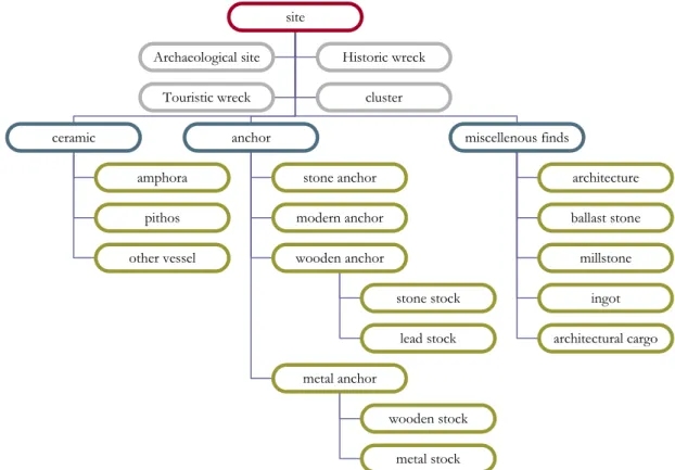
Table 6.1. Different find types. ... 93
Table 6.2. List of nautical charts on Kaş region. ...105
Table 8.1. Software programs used by the contributors...127
Table 8.2. Typological data and measurements on amphora KE-23-A. ...132
Table 8.3. Offset measurement table on cluster KE-23...134
Formula 8.1. Offset measurement formula...134
LIST OF FIGURES
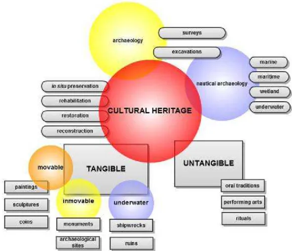
Figure 2.1. Definition and scope of the terms on cultural heritage. ... 17
Figure 2.2. Scope of the surveyed sites. ... 31
Figure 3.1. Definition and scope of the terms on museology. ... 46
Figure 4.1. Scope of the literature review on digital repositories. ... 62
Figure 5.1. Design process of the information system. ... 84
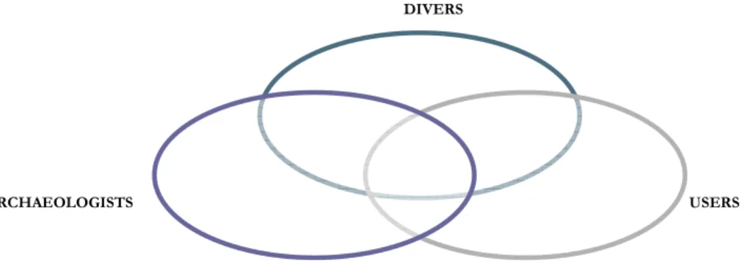
Figure 5.2. Diagram of the participants’ groups. ... 86
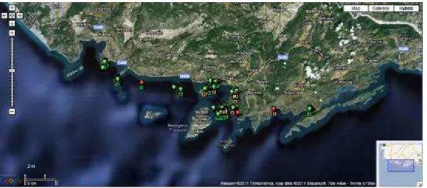
Figure 6.1. Distribution map of the dives... 90
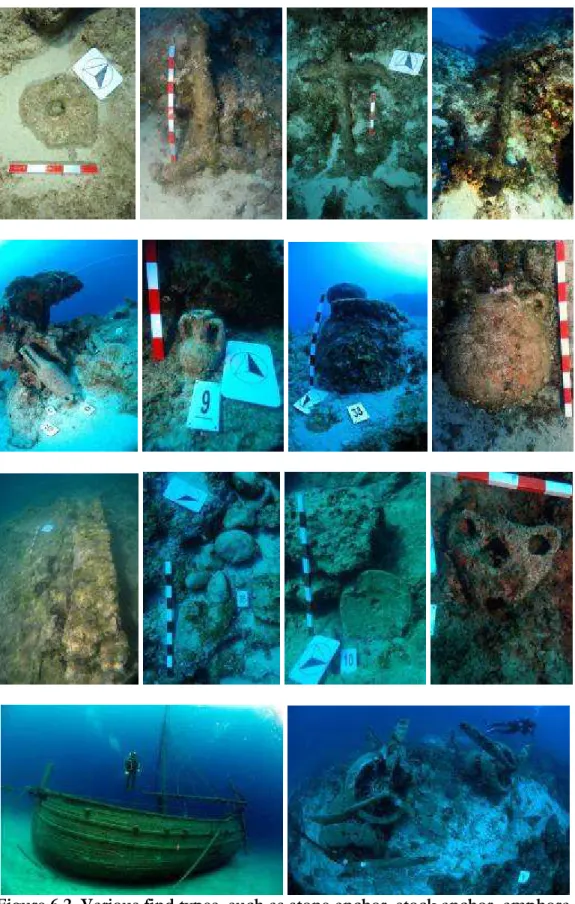
Figure 6.2. Various find types, such as stone anchor, stock anchor, amphora, pithos, architecture, ballast stone, millstone, touristic and historic wreck (photos by O. Aytür, Ö. Yolaç, M. Draman, U. Aksu, T. Ceylan, C. Çimen, G.Varinlioğlu, B. Özkırlı, A. E. Keskin, and A. Kara). ... 92
Figure 6.3. Collected data on KE-23 (photograph by G. Varinlioğlu, sketch by S. Pilge and measurements by D. Atalay). ... 94
Figure 6.4. Organization schema of the first draft datasheets. ... 96
Figure 6.5. Organization schema of the second draft datasheets... 97
Figure 6.6. Organization schema of the final version datasheets... 97
Figure 6.7. Initial sketch of an amphora and of a site with field notes (S. Pilge and G. Varinlioğlu). ...100
Figure 6.8. Scope of nautical charts of Kaş region...105
Figure 7.1. EER diagram representing the data that can be managed by the first prototype database and the connections between them. ...113
Figure 7.2. EER diagram representing the data that can be managed by the second prototype database and the connections between them. ...115
Figure 7.3. EER diagram representing the data that can be managed by the final
prototype database and the connections between them. ...116
Figure 7.4. Comparison of nautical chart and Landsat GeoCover 2000/ETM+, Google Maps satellite images...119
Figure 7.5. Simplified diagram of the system components. ...121
Figure 8.1. Distribution map of anchorage and cargo sites (G. Varinlioglu based on Google Maps)...129
Figure 8.2. Steps for drawing of amphora KE-23-A (S. Pilge based on hand drawing). 132 Figure 8.3. Steps for drawing of Kepez (KE) cargo site (E. Köşgeroğlu, B. Özkırlı, and S. Pilge based on QCAD, GIMP and hand drawings). ...135
Figure 8.4. Steps for enhancing photograph of KE-23 (G. Varinlioğlu based on Gimp). ...136
Figure 8.5. Steps for 3D surface model of amphora KE-23-A (B. Özkırlı based on Google SketchUp). ...138
Figure 8.6. Steps for photomosaic image of the Kepez cargo site (KE), focused on KE-23 and its surrounding (U. Aksu based on Photoshop). ...140
Figure 8.7. Steps for panoramic image of Kepez (KE) cargo site (C. Çimen based on AutoPano)...141
Figure 8.8. Steps for integration of satellite image, site drawing, and photomosaic of the site Kepez...143
Figure 8.9. Screenshot from the information system displaying thumbnails of the drawings. ...144
Figure 8.10. Chronological distribution of the finds...145
Figure 8.11. Future implementations to the information system...146
Figure 8.12. Model of a virtual museum. ...148
Figure 8.13. Photogrammetric immersion...154
Figure 8.14. Tangible interface of the virtual museum. ...159
LIST OF ABBREVIATIONS
AIA American Institute of Architects
AJAX Asynchronous JavaScript XML
AKMED Suna-İnan Kıraç Research Institute on Mediterranean Civilizations
CAD Computer Aided/Assisted Design
DOM Document Object Model
EDM Electronic Distance Measurement
EU European Union
GIS Geographic Information System
GPS Global/Geographic Positioning System
GUI Graphic User Interface
HABS Historic American Buildings Survey
HAER Historic American Engineering Records
HALS Historic American Landscapes Survey
ICAHM International Committee for the Management of Archaeological Heritage
ICOM International Council of Museums
ICOMOS International Council on Monuments and Sites
INA Institute of Nautical Archaeology
JPEG Joint Photographic Experts Group
LoC Library of Congress
MoCT Ministry of Culture and Tourism
NADL Nautical Archaeology Digital Library
NAS Nautical Archaeology Society
NGO Non-Governmental Organization
NOAA National Oceanic and Atmospheric Administration
NPS National Park Service
PHP PHP Hypertext Preprocessor/ Personal Home Page
RDBMS Relational Database Management System
ROV Remotely Operated Vehicle
SAD Sualtı Araştırmaları Derneği (Underwater Research Society) SCUBA Self Contained Underwater Breathing Apparatus
SSS Side Scan Sonar
SOA Shipwrecks of Anatolia
TAMU-CHC Texas A&M University, Centre for Heritage Conservation TAMU-NAP Texas A&M University, Nautical Archaeology Program
TAY Türkiye Arkeolojik Yerleşimleri (Turkish Archaeological Settlements Project)
TÜBİTAK Türkiye Bilimsel ve Teknolojik Araştırmalar Kurumu (Scientific and Technological Research Council of Turkey)
UCH Sualtı Kültür Mirası Projesi - SKM (Underwater Cultural Heritage Project)
UNCLOS United Nations Convention on the Law of Sea
UNESCO United Nations Educational, Scientific, and Cultural Organization
VENUS Virtual Explorations of Underwater Sites
VCM Virtual Museum of Canada
VIZIN Institute for the Visualization of History
VM Virtual Museum
VR Virtual Reality
VRML Virtual Reality Modeling Language
WWW World Wide Web
CHAPTER 1
1.
Introduction
The widespread use of information technologies brought new challenges to the preservation of cultural heritage as well as to museology. A new concept of virtual museum has emerged from a need to acquire, store, research, communicate and exhibit the digital heritage data. Drawing parallels between virtuality and underwater environment, this dissertation aims to explore the conceptual framework for creating a virtual museum of underwater cultural heritage. The objectives of the study are to formulate a methodology for the collection of data on underwater cultural heritage using the non-destructive principles of in situ preservation, and explore the methods of transferring, storing and sharing the collected data in the digital domain. The information system which is designed to store various types of data, also allows collaborative analysis, visualization and communication. Furthermore, at a conceptual level, the digital technologies of the future are explored to promote a framework of a virtual museum and to develop a tool for the nautical archaeology.
Archaeology is a discipline concerned with the past. Its objectives are to explain the origins and development of human culture and history using the remains on the land as evidence. Nautical archaeology, a recent sub-discipline, has emerged in the early 1960’s with the excavation and publication of the Cape Gelidonya Shipwreck by George Bass (1967), following the development of SCUBA equipment and underwater surveying
tools and equipment. Nautical archaeology, also called “archaeology underwater”, such in Turkey, followed the track of land archaeology. Land or nautical archaeologists, like a detective, collect data through excavation and survey (NAS, 2009: 2). Data collection methods sometimes bother the archaeologist, because paradoxically they involve “partially destroying the site that is the object of research without ever being able to recapture the whole of the information it contains” (Forte, 1997: 9). Based on Forte’s remark on the destruction of archaeological data sources, this dissertation proposes a critical appraisal of this irreversible process of data collection by emphasizing the preservation of cultural heritage. Without disturbing the material remains found underwater, this study explores new methods of data acquisition as an alternative to conventional destructive methods used in the discipline of nautical archaeology.
Archaeology studies cultural heritage, depending on how and where the remains are found. Cultural artifacts detached from their original context, are either transformed to a museum object, or when kept in their original place, they deteriorate caused by aggressive urban expansion and development, destruction caused by looting, and general neglect (Kalay, 2008: 1). Similarly, underwater cultural heritage has been under escalating threat due to the extensive number of divers and underwater exploration techniques that gave rise to destruction of wrecks and immersed sites (UNESCO, 2001). Darkness, low temperature and low oxygen rate, characterizing the underwater environment offer ideal preservation conditions for non-organic cargo remains, anchors, ceramics etc. In Turkey, mostly visited by recreational divers rather than nautical archaeologists, these cargo remains offer important clues about the past even without having to be removed from their original context. Nevertheless, in Turkey the priority is largely given to excavations, as a result of which unearthed artifacts are removed from their original
contexts and transferred to museums. The museum is considered to be the ideal place for the highest level preservation of this “salvaged” cultural heritage.
The International Council of Museums (ICOM) founded in 1946 defines the museum as “a non-profit, permanent institution in the service of society and its development, open to the public, which acquires, conserves, researches, communicates and exhibits for the purposes of education, study and enjoyment” (ICOM, 2007). These activities of musealization include the collection, conservation and research of museum objects through exhibition for a better communication with the public. However, separated from its context, isolated from its meaning; the cultural heritage is enclosed in a single place, which may be termed a heterotopian space. Foucault defines the museum as a space of difference, a space that is absolutely central to a culture but in which the relations between elements of a culture are suspended, neutralized, or reversed (Foucault, 1998: 178). Like other cultural institutions such as libraries, the museum as a product of the Enlightenment, imposes universal categories, classifications, and order on cultural artifacts. Once an object is detached from its original context and placed in a museum environment, the archaeologists categorize, classify, and derive meaning in order to impose a new order on artifacts. This dissertation explores the museum practices of acquiring, preserving and researching of cultural objects in the virtual domain taking into consideration Foucault’s criticism of the museum.
Nowadays, virtuality is mostly associated with computer technologies, and is often conceived as a tool to achieve something intangible, fictitious, and unreal (Lévy, 1998). As defined by Lévy, the media scholar, virtuality is by no means an opposite of the real; rather, it offers potentialities other than the ones in real space. Referring to Benjamin’s
famous essay “The Work of Art in the Age of Mechanical Reproduction”, the digital heritage has become a separate entity, detached from its original context, bringing the new opportunities to the digital heritage data. The digital domain offers new possibilities to transform the physical objects into digital formats, to store and preserve in digital repositories, to analyze and disseminate, and to securely exhibit through digital systems. This phenomenon of digital revolution is studied in a variety of disciplines concerned with theories of new media and cyberspace (Manovich, 2001). Manovich, a prominent theorist of new media, defined the general principles underlying the new media with connotations of numerical representation, modularity, automation, variability, and transcoding. Similarly, Gibson (1984) writing on cyberpunk, defined the concept of cyberspace as the site of computer-mediated communication providing an environment for new conceptions of space and spatial theories, while new media emphasizes the communicative aspect of virtuality. This dissertation treats the collection, visualization and communication of data within the framework of the above mentioned conceptions of space and visual communication.
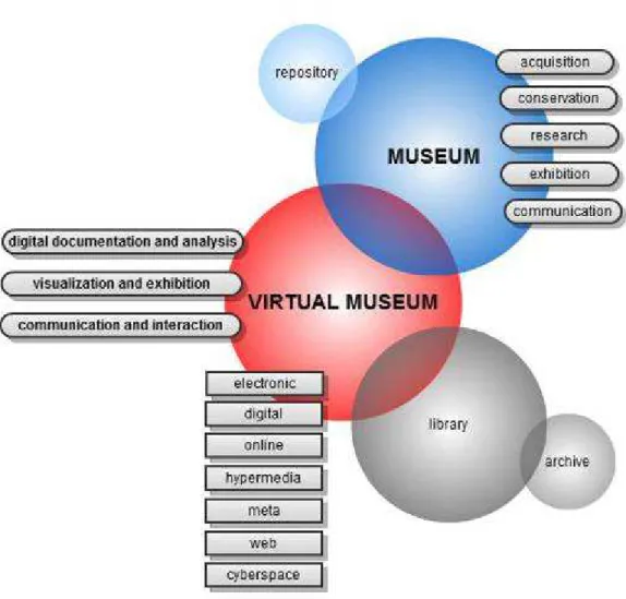
Virtual museum is a product of the revolutionary changes in digital reproduction, which led to the emergence of new definitions in the field of museology. Since its conception in 1995 as recommended by the policy statement of ICOM, the concept of “virtual museum” is still being developed and continually adapted to new technologies. There are several definitions for virtual museum introduced by different institutions, thinkers, and researchers. Schweibenz categorizes virtual museums as brochure, content, learning, and virtual museum. The first three categories refer to the informative web sites of “brick and mortar” museums that are institutions with more conservative attitudes towards information technology (Schweibenz, 2004: 3). The very last, namely the virtual
museum is where digital collection and information are linked parallel to Malraux’s vision of the “museum without walls” (Malraux, 1947). Not bound by physical constraints, the digital objects are housed and displayed in this repository. The need to store large volumes of data by using digital technologies formed the basis for the idea of creating an analogy of the concept of museum, as museums no longer function simply as repositories of objects. Instead, they are increasingly serving as archives or storehouses of knowledge (Parry, 2007). Consequently, practices at virtual museums have experienced a shift in the way this knowledge is acquired, preserved, researched, exhibited, and communicated.
Documenting or recording is capturing the information which describes the physical characteristics, condition, and use of the cultural heritage. Cultural heritage documentation makes use of computerized techniques to acquire and preserve the information produced. Particularly in archaeology, the computerization of data helps solving specific problems in saving, presenting and understanding archaeological features. Through advanced technologies of digital documentation and analysis such as visual, dimensional, locational, aerial, environmental, and underwater tools, the information system serves the needs of archaeologists. These practices of knowledge formation can be considered as the initial steps towards a museum.
The visualization of digital heritage is one of the most attractive ways in which computer technology can be employed in the field of archaeology. The use of this technique allows visual reproduction of data through representation, modeling, and display. These methods of display allow the creation of virtual exhibitions in the web environment. The virtual domain, unlike the “brick and mortar” museum, is a flexible
medium for sharing information in various formats, such as digital images, video recording, hyperlinked texts, etc. Moreover, the digital domain recodes the way the information is displayed in such a way to move it from a passive to a more interactive style.
New combinations of objects may be created automatically. In fact, users may create their own combinations of objects using the search and browse functionalities applied to object-level metadata. This emphasis on interactivity allows multiple user experiences, thus contributes to the development of interdisciplinary aspect of display. In the web 2.0 environment, new datasets can be created through user participation. The conventional definitions of cultural institutions such as libraries, repositories, and museums are redefined by digital technologies.
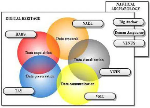
In the field of heritage preservation, five digital repositories stand out in their applications of the practice of virtual museology. Historic American Building Survey (HABS) , dealing with acquisition of building documentation data; the Turkish Archaeological Settlements (TAY) project, focusing on the conservation of archaeological data by archiving publications; Nautical Archaeology Digital Library (NAPL), a research tool on multilingual manuscripts; Institute for the Visualization of History (VIZIN) projects for the visualization of excavated sites; and Virtual Museum of Canada (VCM), a user-centered virtual museum project. The digital repositories focusing on three main types of underwater remains, namely anchors,
amphorae, and sites are respectively Big Anchor, Roman Amphorae and Virtual Explorations of Underwater Sites (VENUS) projects. These digital projects illustrate the diverse applications of cultural heritage management. Their assessment is a useful
exercise to conceptualize the information system for a virtual museum of underwater cultural heritage.
Following this theoretical background, the underwater environment, like the conception of virtuality, is considered as infinite and unexplored. The unidentified remains hidden in this environment are both the subject and object of the virtual museum. This cultural heritage comprises all underwater traces of human maritime activity along the Lycian region, the southwest Mediterranean coasts of Turkey, specifically in the environs of Kaş. Following the general preservation methodology proposed by the UNESCO “Convention on the Protection of the Underwater Cultural Heritage” in 2001, which is not yet signed by the Turkish authorities, a data collection methodology of underwater cultural heritage was developed by the author and her team, who conducted underwater archaeological surveys in Kaş region as part of the Underwater Cultural Heritage Project (UCH)1. Driven by this methodology, an information system was designed and
developed to create a web-based and open-content platform for knowledge-building through the collaboration of multiple participants with different backgrounds and academic interests. This dissertation also discusses the analysis, visualization, and communication tools that are not integrated into this information system. Although the automation tools are not yet linked to the information system, the necessary technical steps required to establish this link are presented in order to suggest the methods of converting this information system into a virtual museum. Future features on the automation of analysis and documentation, exhibition and visualization, and the system of communication and interaction are briefly discussed. The methodology of data
1 Data collection and processing for an online site called Underwater Cultural Heritage Project (UCH)
currently carried out since 2007 with the permission of the the MoCT, since 2009 on behalf of Güzden Varinlioğlu. Among the fundamental goals of this project is the intention to contribute to the management of the underwater cultural heritage of Turkey.
collection and the web-based information system contributed to the model of a virtual museum (VM). Although this museum is not in place yet, the dissertation provides several suggestions towards its design and implementation. These suggestions are the products of the integration of computer science, museology and archaeology.
1.1. Objectives and Methods
Most studies on virtual museums are related to the integration and interpretation of information but there is still lack of systematic methodology for the collection, preservation, and dissemination of this digital data through web-based systems equipped with adequate visualization and communication tools. This dissertation formulates a framework for a virtual museum for the underwater cultural heritage of Turkey. The major component of this framework is a web-based information system, which was developed by three programmers for potential virtual museums that incorporate collected data, research, and storage of underwater cultural heritage. The design of the information system for this virtual museum is based on the archaeological surveys done in the pilot region of Kaş, on the Lycian coast. As a pilot study, the objective is to develop a data collection methodology derived from the principles of in situ preservation. This methodology is based on developing standard datasets that are collected by recreational divers who are not, by education, archaeologists. The system has been developed with the objective to build and test methods for data acquisition, conservation, and research. These methods are central to the process of transporting the data collected in the field to an online information system.
Initially, through a training session on nautical archaeology, these divers received a basic background that enabled them to participate effectively in the development of the design of the information system, as well as in future surveys for the collection of underwater data. To ensure the sustainability of the project, the methodology of data collection intends to rely on simple and standard tools, but detailed observations and measurements.
In this data collection methodology, datasheets, paper versions of the information system, are developed and tested on recreational divers. The overall design of the systematic information system is tested first by divers in the field, and later on by archaeologists and other users online. Using the remarks and comments of users on the collected data, datasheets, and database, the system is redesigned according to the needs of archaeologists. The objective is to systematize the ambiguous data of various media such as the measurements, sketches, photographs, drawings, images, notes, geographical coordinates, and any other archaeological element.
This online information system for systemic data collection, description, and interpretation, currently contains information on 22 geographically distributed archaeological sites. Combined with the GPS locations of sites and findspots, the result of integration of the database with Google Maps illustrates the distribution of sites along the Kaş shoreline. Particular attention is paid to collecting the information digitally and to refraining from disturbing the material culture. For this reason, artifacts are recorded with special care to maintain them untouched and in situ. This non-destructive recording method abides by the principles of the conservation and the protection of the sites accepted in the UNESCO 2001 Convention (UNESCO, 2001).
It is within this framework that the multiplicity of information and knowledge contributes to the unique nature of a virtual museum, where the sources of data and means of data collection are as diverse as the process is interactive. One of the objectives of this dissertation is to investigate the contribution of digital technologies to the preservation and presentation of cultural heritage. Another objective is to determine in what other ways digital technologies can contribute to data storage and sharing, and thus, to the development and further articulation of the concept of the virtual museum.
Using the capabilities of the information system separately produced visual media and archaeological interpretations are uploaded to the system through the collaboration of archaeologists and other interested parties. Based on the comments of the participants of this collaborative process, advanced tools should be integrated to the system. These tools consist of open source software programs for data analysis, visualization, and communication. Archaeologists use the information system to derive archaeological information based on the descriptions, distribution maps, and statistical studies of the recorded measurements of finds. Once the archaeological information is driven, the visualization of data can be considered as the next step towards a virtual museum, as well as a data analysis method for the archaeologists. Through the drawings of sites and finds, enhancements of the photographs i.e. the digital darkroom applications, processing of the photographs for photogrammetric information, and 3D reconstruction of objects, the system can be ready to be presented in the form of an online exhibition. As a communication tool, the exhibition of the finds can be thus achieved through locational, chronological and visual maps. Along with these navigation options, the system should have tools for query. Still, even with the inclusion of these tools, the information system does not actually result in a virtual museum. The virtual
museum should have automated tools for digital documentation and analysis, a more powerful visualization for exhibition and an interactive user interface for the communication of the produced information. Moreover, beyond the limits of currently available technologies, further features, such as automatic archaeologist, visual virtuality and immersive interaction are presented for the virtual underwater museum of the future.
Among the features that will be developed in future is the conceptual discussion of the artificial intelligence of an archaeologist. This concept precedes the development of advanced visual features for designing an immersive user interface. The automatic archaeologist is a computer agent who thinks and acts rationally like an archaeologist. This feature equipped with artificial intelligence can perceive the environment, do research on publications and answer archaeological questions by image processing and other advanced technologies. The visual features of the system, such as computer reconstructions and photogrammetric tools are explored as well as the tangible properties using haptic devices such as gloves. Thus, the virtual system becomes immersive by conveying the senses in the digital domain. In this tangible and virtual environment, the knowledge can be created through the collaborative environment of web. This makes possible the coexistence of various navigation tools that do not depend on dictated curatorship.
Having conducted the thesis study in the Lycian coast of Turkey, and having specific research questions on this region, the objectives were to form a methodology for data collection and recording through underwater survey for the research, preservation, investigation, and display of Turkish underwater cultural heritage by means of a virtual
museum, to bring a new approach to redefine the conception of the museum in virtual space through the collaboration of such disciplines as nautical archaeology, museology, and information technologies. In this system, non-governmental organizations and academic institutions will be able to collaborate and by sharing the approaches specific to their disciplines thus contribute to the development and improvement of the virtual museum and share different approaches.
1.2. Dissertation Outline
This thesis investigates a framework for the design of a virtual museum by data collection, collaboration and dissemination of underwater cultural heritage through field surveys and an online information system. The theoretical and practical basis of the dissertation is discussed in two parts. Part I, composed of chapters 2, 3, and 4, includes respectively the definition of the proposed preservation methodology on underwater cultural heritage, discussions on the concepts and practices of the virtual museum, and the literature review on virtual museum and information system examples. Part II, composed of chapters 6, 7, and 8, includes the implementation of the data collection in the field, storage and sharing using the information system, and a model of virtual museum along with tools for analysis, visualization and communication. Finally, some future features are conceptually explained to lead future studies on the virtual museum of underwater museum.
Part I starts by explaining theoretical issues with a clear definition of underwater cultural heritage in chapter 2. Having defined underwater cultural heritage in relation to archaeology, nautical archaeology and historical preservation, a critical review of the
selected legal frameworks is presented in order to underline the relevance of in situ preservation methodology. Also, the gaps in national legislations that do not cover the research and promotion of archaeological potential of the region are summarized in order to emphasize the preservation methodology chosen throughout this dissertation. In chapter 3, theoretical approaches that are taken as the basis for the development of virtual museum are explained, including the definitions, theoretical criticism and practices on the concepts of museum and virtuality. This chapter underlines three practices of virtual museum and archaeology in conjunction of the developments of information technology: digital documentation and analysis, visualization and exhibition, communication and interaction. In the chapter 4, the existing information systems, repositories, and virtual museums used for the preservation, collection, dissemination and exhibition of cultural heritage are summarized, with a focus on information systems used in nautical archaeology (See Appendix F).
Part II presents the implementations of the proposed model, starting with a summary of the research setup of the study in chapter 5, including the problem definition, research questions, participants, and the methodology. This chapter establishes a common ground of other projects conducted under the heading of Kaş Archaeopark Projects2.
The design process of the information system, which is implemented with divers of different academic backgrounds, is also introduced. The full list of the participants and their contribution are presented in Appendix E. Chapter 6 presents the methodology used for the data collection, including the evaluation of datasheets, visual materials, and maps. Three stages of the design of the data collection methodology are summarized
2 The foundations of “Kaş Archaeopark Projects” were laid in 2006 so as to have multi-disciplinary
academic and popular projects in order to gain attention of local people, archaeologists, and everyone interested in historical and archaeological potential of Kaş and its environment.
with the diagrams of the general organization schema. The detailed explanations of each component of underwater cultural heritage and the datasheets are Appendix A and B. The analysis of the datasheets and the clues found on the research diaries about the divers’ data collection process form the basis of the design of information system in chapter 7. Based on the users’ needs and comments, this chapter includes the design phase of the three prototypes based on the users’ comments. The architecture and components of the final design are briefly presented in addition to the general features, such as mapping, data validation, and record relations. The explanation of the technical details is given in Appendix C and D.
Chapter 8 discusses the conceptual design of the virtual museum system as theoretically explained in chapter 3. Providing data storage, sharing, and collaboration, the information system is used for data analysis and visualization. Separately produced in open source software programs, textual and visual analysis of the data is uploaded to the system through the collaboration of archaeologists and other interested parties. Although this museum is not in place yet, several suggestions towards its design and implementation, such as digital documentation tools for data collection, artificial intelligence technologies for analysis, a more powerful visualization for exhibition and an interactive user interface for the communication of the produced information are presented towards the end of the chapter. Finally, the results of the discussion related to virtual museum, the archaeological surveys and information system are summarized and discussed in the conclusion to lead to further studies.
CHAPTER 2
2.
Underwater Cultural Heritage
The study of underwater cultural heritage, as related to the field of nautical archaeology is a major scientific discipline about research on archaeological, historical and architectural sites and objects (Gifford, 1985: 373). These sites comprise archaeological periods from the Late Bronze Age to the present, to ships and harbors of the historic past, which are traces of nautical activity (Bass, 2005). Nautical archaeology, covering the disciplines of maritime, marine, wetland and underwater archaeology, is a recently established branch of archaeology. Its beginnings are identified with the excavation and publication of the Cape Gelidonya Shipwreck dating from the Bronze Age off Turkey in the early 1960s (Bass, 1961). As a new discipline, nautical archaeology, sometimes called “archaeology underwater” followed the tracks of land archaeology (Bass, 1966). The term “archaeology underwater” implies the implementation of the theories and practices of land archaeology to the remains found underwater. Thus, nautical archaeology had a limited exchange of ideas with other disciplines, among which is historic preservation.
The preservation of cultural heritage including underwater heritage is a relatively novel topic in archaeology. To avoid any confusion and conflict between these three disciplines, namely archaeology, nautical archaeology, and historical preservation, and to understand the theoretical background of preservation principles on cultural heritage, it
is necessary to define the key terms presented by the prominent institutions. The perspectives of preservation of United Nations Educational, Scientific, and Cultural Organization (UNESCO) at the international level, National Park Service (NPS) in US and Ministry of Culture and Tourism (MoCT) in Turkey define the creation, usage, conceptualization and transformation of these three disciplines.
Archaeological surveys and excavations have traditionally used destructive methods of data acquisition. However since 1931, when the Athens Charter was drafted by the International Museums Office, international conventions on the protection of cultural heritage made possible the development of both national and international legal frameworks. These frameworks are presented in order to support and promote the in
situ preservation. The latest legal framework currently signed by international authorities follow the principles of in situ preservation, which prohibits the dislocation of material culture. In contrast to the international consensus, in Turkey, this preservation method is still not considered as an established scientific method for either on land or nautical archaeology. The emphasis is largely given to excavations, the destructive methods of data collection. However, when the non-organic underwater remains with their excellent preservation condition in the clear waters of Turkey are examined, the principles of in
situ preservation are preferred to be followed during the surveys on the Kaş shoreline.
2.1. Definition of Terms
As one of the aims of this dissertation is to introduce new concepts to the field of nautical archaeology, it is imperative to use a carefully chosen terminology (Fig. 2.1). Archaeology and its subsequent discipline, nautical archaeology studies the material
remains to reconstruct the secrets of history. Paradoxically, archaeological data collection methods lead to the partial destruction of the historic evidence, although historic preservation favors the long term preservation of cultural heritage. The methods and terminology used in archaeology reveal the differences and contrasts between principles of archaeological research and historic preservation.
Figure 2.1. Definition and scope of the terms on cultural heritage.
2.1.1. Archaeology
Renfrew and Bahn define archaeology as partly the discovery of the treasures of the past, partly the careful work of the scientific analysis, partly the exercise of the creative imagination (Renfrew and Bahn, 1991: 9). Considered both a science and humanities,
one of the main concerns of archaeology is the “study of past societies primarily through their material remains –the buildings, tools, and other artifacts that constitute what is known as the material culture left over from former societies” (Renfrew and Bahn, 1991: 9). This discipline involves the methods of survey, excavation and eventually the analysis of data collected in order to learn about the past. However, as stated by Sprinkle Jr., these methods result in the “destruction of the past through excavation, analysis, and interpretation” converting the artifacts into field notes of the archaeologists by isolating the material from its original context (Sprinkle Jr., 2003: 253).
Unlike many other scientific disciplines, the practice of archaeology is not a repeated experiment or procedure. Forte stated that “excavation and fieldwork are sometimes rather embarrassing for the archaeologist, because (paradoxically) they involve partially destroying the site that is the object of research without ever being able to recapture the whole of the information it contains” (Forte, 1997: 9). The excavation that is the main source of data collection for the interpretation and observation of archaeologists is in its nature a destructive process, which proves the profession’s concern for recording (Sprinkle Jr., 2003: 253). As a result, archaeologists are devoted to archaeological records. As Sprinkle Jr. criticizes archaeologists, (they) “live and breath data because the archaeological record is an elusive, sexy, democratic past, not one generated by clerks, accountants, or politicians, but by the folks” (Sprinkle Jr., 2003: 270-271). As in the case of widely known movie trail, “Indiana Jones”, archaeologists feel the romance and mystery of archaeology. For most archaeologists, the excitement is in discovery through excavation and fieldwork, not in revisiting previously excavated materials or places. They want to touch the artifact, and discover the hidden past on the earth.
Since its early days in the late 19th century, the practice of archaeology has evolved to a
less destructive method. Later in the 20th century, with the advances in technology and
its usage in archaeology, the excavations and surveys started to use advanced technologies borrowed from other disciplines. Still, even with adequate tools and techniques, the tradition of archaeology favors excavations rather than non-destructive research and preservation methods. As the same site on land is mostly occupied by various civilizations during different periods of history, archaeology on land relies on mainly excavations and surveys to acquire data. On the other hand, the archaeological remains found underwater mostly include more than clues, in fact sufficient information on the history of nautical activities.
2.1.2. Nautical Archaeology
Considered as a branch of archaeology, nautical archaeology is the systematic study of past human life, behaviors, activities and cultures using material remains as well as other evidence found in the underwater environment (Delgado and Staniforth, 2002). The term “underwater archaeology” mostly refers to the environment in which the practice of archaeology is undertaken (Bass, 1966). Contemporary definitions of nautical archaeology overlap with the definitions of maritime, marine, underwater and wetland archaeology. Maritime archaeology deals with humans and their interactions with the sea. It can include sites that are related to maritime activities such as lighthouses, port constructions as well as other sites found underwater. Marine archaeology is the archaeological study of material remains created by humans that are submerged in the marine environment (e.g. submerged aircraft). Wetland archaeology is the study of humans and their interactions with the water, not definitely in marine environment.
Nautical archaeology studies ships and shipbuilding with the techniques of underwater exploration, excavation and retrieval. This dissertation uses the term nautical archaeology, also preferred by Nautical Archaeology Society (NAS) in the UK, Institute of Nautical Archaeology (INA) in the USA, prominent institutions in this field, as it covers the study of all the remains of nautical activity.
“How can you call this planet earth, when it is quite clearly water?” is the general slogan of nautical archaeologists. Different from the archaeology on land, while the sea surface shows no traces of these ships and buildings, their remains lie on the seabed, safely protected by water (Delgado and Staniforth, 2002). Unlike the remains found on land mostly covered by earth, once discovered in the depths of water, the shipwrecks give important clues about the past. Shipwrecks are often described as “time capsules”, as the term describes the essence and excitement of one instance in time, a slice through history when belongings and commodities on these ships are well preserved (Gibbins, 1990: 35). Unless looted or destroyed by human and natural factors, inorganic archaeological remains found underwater are protected and preserved by the water. Partially submerged under the seabed, the visible remains found underwater include important clues for the archaeologists without any archaeological excavation. Usually visited by recreational divers, rather than nautical archaeologists, who are not found in Turkey in large numbers, these archaeological remains are mostly encountered in most of the diving activities.
In Turkey, underwater archaeology is mostly associated with cargo remains of the nautical activity. The visible and long-lasting remains are amphorae, anchors and other materials carried by the ships as well as architectural elements of the harbors, submerged
settlements etc. Once exposed to sea water, organic remains i.e. wooden parts of shipwrecks disintegrate by living organisms. When hidden under the seabed, the organic parts of the shipwreck hidden under their cargo materials are protected thus can be found intact after years. Sealed by a layer of encrustation, remains of the cargo offer substantial clues about archaeological information, such as shape, texture, and dimensions of the earthen artifacts, even without disturbing the material culture.
2.1.3. Cultural Heritage
Heritage is defined as something that is or should be passed from generation to generation because of its value (Webb, 2003: 28). Similarly, UNESCO interprets cultural heritage as “the entire quantity of artistic or symbolic signs handed on by the past to each culture and, therefore, to the whole of humankind” (UNESCO, 2008). Given this, any heritage vessel that is movable such as paintings, sculptures, coins; immovable, such as monuments, archaeological sites; and those found in an underwater setting such as shipwrecks, ruins are defined as tangible cultural heritage. According to the Convention for the Safeguarding of the Intangible Cultural Heritage, intangible cultural heritage consists of the practices, representations, expressions, knowledge, and skills that individuals, groups, and communities recognize as part of their identity (UNESCO, 2003). In this context, human expressions such as oral traditions, performing arts, and rituals are examples of intangible heritage (UNESCO, 2008). In this dissertation, cultural heritage is considered “archaeological heritage” is that part of the material heritage in respect of which archaeological methods provide primary information (UNESCO, 1990). Thus, the broad definition of cultural heritage covers the usage, conceptualization, and transformation of al the above mentioned descriptions.
The term cultural heritage is defined by the National Park Service (NPS), the federal agency that manages all parks, many monuments, and other conservation and historical properties in the United States. According to the NPS, cultural heritage reflects the significance of collective memory and defines the identity of the community. To encourage consistent preservation practices, NPS has developed guidelines and standards that guide the preservation methodology. Named as the Secretary of Interior’s Standards, Guidelines of Archaeology and Historic Preservation are intended to promote responsible preservation practices that help to protect cultural resources (Weeks, 1995). These guidelines offer four treatment approaches such as preservation, rehabilitation, restoration and reconstruction. The preferred treatment is preservation rather then the other three consecutive treatment methods. These guidelines promote the preservation of the original as a preferred option.
Both UNESCO and NPS define cultural heritage as the place-oriented and physical manifestations of heritage assets; as well as the non-place and non-physical aspects. In Turkey, the Ministry of Culture and Tourism states in the Law Protecting the Cultural and Natural Heritage3 the definition of cultural property as "[A]ll movable and
immovable property above or underground or underwater that belongs to the prehistoric and historic periods and relates to science, culture, religion and the fine arts” (MoCT, 1983). This legislation establishes the national inventory of the cultural natural heritage as a form of protection.
Similar to cultural heritage, underwater cultural heritage means “all traces of human existence having a cultural, historical or archaeological character which has been partially
3 The Turkish translation for the Law Protecting the Cultural and Natural Heritage is Kültür ve Tabiat Varlıklarını Koruma Kanunu.
or totally under water, periodically of continuously, for at least 100 years” (UNESCO, 2001). Within these interwoven disciplines on the study of underwater cultural heritage, UNESCO estimates that there are over 3 million undiscovered shipwrecks. Many of the famous shipwrecks are looted, including the Armada of Philip II of Spain, the Titanic, the fleet of Kublai Khan, and many other along the Turkish coasts when compared to the very limited number of shipwrecks that have been excavated using scientific and archaeological methods (Delgado and Staniforth, 2002). Similarly, the remains of numerous ruins and submerged settlements are looted more often, since they mostly lie in relatively shallower water. The excavations of Port Royal in Jamaica by Institute of Nautical Archaeology (INA), the ruins of Alexandria Lighthouse known as Pharos by Centre d’Études Alexandrines are the significant examples of systematic excavations of the underwater settlements. However, as explained above, illegal looting of the artifacts, sites and submerged sites is not the only destruction. No matter how careful archaeological research is, archaeological excavation includes irreversible modifications in cultural heritage sites. As a result of archaeological research, these objects of material culture are decontextualized and isolated from the milieu they represent. To prevent this decontextualization, several conventions, laws and guidelines were created in order to establish a legal framework at national and international level.
2.2. Legal Frameworks for the Preservation of Cultural Heritage
The legal issues relating to the discovery, survey and excavation of underwater cultural heritage were once described as a “legal labyrinth” (NAS, 2009: 45; Altes, 1976). Borrowing many rules from different professional fields like historic preservation, archaeology, and nautical archaeology, research on underwater cultural heritage follows
a path through this network of national and international laws and regulations. As the underwater cultural heritage is generally found in the seas and oceans, the United Nations Convention on the Law of the Sea (UNCLOS) is the particular international law to be referred (NAS, 2009: 45). Adopted in 1982, this convention outlines systematically the divisions of the coastal waters into five different zones such as deep seabed and the high seas, continental shelf, exclusive economic zone, contiguous zone, and territorial seas. Defined mainly by distance to shoreline, called as coastal baseline, these zones named above have different regulations in terms of natural resources, navigational rules and the ownership of cultural heritage. When this convention was negotiated, the underwater cultural heritage was not the main concern; however it is important to know where land ends and sea begins (NAS, 2009: 45). As the main focus of the surveys conducted for this dissertation is the territorial sea, which extends up to 12 nautical miles from the coastal baseline, Turkey has the exclusive right to regulate all activities relating to underwater archaeology.
The two most important policies concerning the preservation of wreck sites were created by the UK and USA authorities. Current English policy heavily relies on a voluntary approach to heritage management. It relies on local organizations for a comprehensive, national vision for the management of underwater cultural heritage (Oxley, 2001: 12). In the case of the Unites States, the current legislative environment frames the management of underwater cultural heritage. Depending on where the resource is located and subject to specific and individual requirements, this heritage falls under one of the three regimes: General Maritime Law (1789), the Abandoned Shipwreck Act (1987) and the Marine Sanctuaries Act (1972) (Street, 2006: 468). The first outlines the laws of salvage and finds. The latter two acts of more recent period are
about the ownership of the shipwrecks. However countries such as Turkey consider all cultural heritages to be owned by the government and no private trade in these items is allowed (NAS, 2009: 49). Some countries, such as Greece and Turkey, restrict search and diving activities, in the case of Turkey, a permission from Ministry of Culture and Tourism (MoCT) is required to conduct underwater surveys (NAS, 2009: 49).
2.2.1. National Perspective
Although the legislations in the UK and USA help us to draw a general outline of theory and practice of preservation, an overview of Turkish legislations is needed to evaluate whether these methods are applicable to Turkey. Turkish lands and waters have a vast amount of cultural heritage when compared to other European and especially American lands and waters. The complexity of remains from ancient civilizations is so vast that not only adaptation but also redesign of the legal framework is needed.
Turkey is geographically situated on the land that housed numerous civilizations throughout the history. As a result, Turkey is a prominent research area for many national and international scholars from diverse disciplines such as archaeology, architecture, history and historic preservation (Blake, 1994). The MoCT compiles the reports of these diverse archaeological activities in the annual International Symposium of Excavation, Survey and Archaeometry.4 The published conference proceedings are
accepted as the primary resource of documentation of the field studies conducted in Turkey.
4 The Turkish translation for the International Symposium of Excavation, Survey and Archaeometry is
In Turkey, MoCT is responsible for cultural heritage management activities. Department of Antiquities5 is the department within the Ministry that regulates the permits for any
archaeological and historic preservation study and research. Following the earlier Turkish legislation, the Antiquities Law6 (1973), the Ministry passed the Law Protecting
the Cultural and Natural Heritage in 1983. This legislation was designed to be more comprehensive in order to protect and conserve the expanding meaning of cultural heritage (Blake, 1994: 276). According to this law, archaeological sites are classified into three groups with respect to the characteristics and values they carry. According to the significance and archaeological values, these sites are graded as first, second and third degree. This grading defines the level of intervention, for research, conservation and restoration.
Similar to archaeological sites on land, there is a vast amount of sites along the Turkish coastline where ancient shipwrecks or sunken archaeological ruins of ancient settlements are located. Most of the wrecks at shallow depths within the recreational limits have already been looted by sponge divers and recreational divers in the 1960s and 1970s. The current law passed in 1983 extended the scope of the antiquities legislation to cover for the first time underwater archaeological sites and other remains, while retaining most of the perspectives of the 1973 law (Blake, 1999: 173). With prohibitive perspectives, some designated areas are declared to be underwater protection zones. In these protection zones, recreational diving activity was prohibited to protect this underwater cultural heritage. Although the law expected to designate “no diving zones” as a solution for looting and destruction of the archaeological heritage, these zones became more attractive for public. Even though it is not clearly defined how they are designated, it is
5 The Turkish translation for the Department of Antiquities is Kültür Varlıkları ve Müzeler Genel Müdürlüğü. 6 The Turkish translation for the Antiquities Law is 1710 sayılı Eski Eserler Kanunu.