MODELING MORPHODYNAMIC PROCESSES IN MEANDERING RIVERS WITH
UAV-BASED MEASUREMENTS
Orkan ÖZCAN
1, and Semih Sami AKAY
2[1]
Istanbul Technical University, Eurasia Institute of Earth Sciences, 34469, Maslak, Istanbul
[2]Istanbul Arel University, Real Estate and Property Management, 34295, Kucukcekmece, Istanbul
ABSTRACT
Accurate surface models are a crucial component of studies of morphodynamic modeling of rivers and river channel evolution. The high flows that rivers have are caused by changes in flood bed or low canal flow, also it changes river channel morphology. Floods that occur during the spring months cause significant geomorphological changes. In addition to this, low flows during the summer also trigger erosion and superficial accumulation in the ongoing process. Using an accurate, high-resolution, seamless surface models of the river channel and floodplain allows to detect morphological changes of the whole river channel more accurately than using traditional methods. This enables a more comprehensive view of the riverbed evolution. Therefore, high-quality topographical data at different scales are required to study fluvial processes and river dynamics.
Nowadays, a combination of photogrammetry and Unmanned Aerial Vehicle (UAV) systems is widely used for various applications, especially for 3D surface modelling and large scale mapping. UAV systems offer many advantages in terms of cost and image resolution when compared to terrestrial photogrammetry and satellite remote sensing systems. In the study, aerial imaging was carried out via UAV to produce very high resolution surface models based on Structure from Motion (SfM) technique. Multi-temporal topographic data were produced and morphodynamic processes in the Büyük Menderes River were modeled. Thus, UAV-based a fast and practical way to derive volumetric quantity of lost/gained soil was developed.
Index Terms— UAV, SfM, erosion, river morphology 1. INTRODUCTION
There is a decrease in the amount of sand, where the rivers carry to the sea due to the deterioration of the sediment budget so erosion can be seen in the mouth of the river and in the coastal strips around it [1, 2]. In addition, sand and gravel quarries prevent continuous sediment transport from the river to the downstream. Therefore, the unconscious removal of sand and gravel from river beds is becoming evident for river beds and coastal erosion. The literature suggests that they cause erosion and morphological changes in the coastal regions where the rivers are poured [3].
It is clear that some of the problems seen in the coastal area are caused by the mismanagement of river basins. For this reason, it is suggested that management of coastal areas and management of river basins should be considered with an integrated approach in terms of sediment budget [1, 2]. The sand potentials of rivers should be investigated and the amount of reduction should be determined so administrative measures related to these issues should also be put forward.
In addition to the terrestrial and satellite remote sensing methods, it is seen that UAV, which are the latest technology, are being used to examine sediment accumulation and reductions in the meanders in the rivers. Volumetric and spatial calculations can be made with point cloud data and 3D surface models generated from the data of unmanned aerial vehicles. Fonstad et al. (2013) compared data derived from SFM in the flood bed system with airborne data and reported an average difference of 0.6 m between topographic maps reproduced by two different methods. Temporal differences in sediments of rivers can be determined by processing aerial photographs obtained from UAV at different times in order to monitor changes in sediment quantities in the rivers [4, 5]. Monitoring the changes in the meander curves, DTMs have been produced by processing the data obtained from UAV and it can be seen that sediment variations in the meanders can be calculated during the year with the produced DTMs [6].
2. STUDY AREA
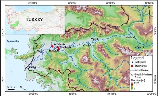
The Büyük Menderes basin is located in the Aegean region, which is one of the seven regions of Turkey and the largest river basin in the Aegean (Fig.1). The Mediterranean climate prevails in this region, which is generally warm, dry in summers and warm, and rainy in winters. The mountains extending up to the sea in the basin ensure that the moist and warm sea climates can reach the watershed, while protecting the coastal areas of the waterside against frost. In the inner parts of the basin, the effects of the sea are decreasing and the continental climatic characteristics are seen as the climate with increasing height [8].
The Büyük Menderes basin is a graben that formed two major fault outcrops extending in the west-east direction.The
7886
average annual rainfall in the Büyük Menderes Basin is 635 mm and the total average evaporation is 2122 mm [7]. The Büyük Menderes River is 584 km long in the east-west direction with an average flow rate of 44 m3/s. Due to its
ecological characteristics, it has a basin area of about 26x105
ha which is the leading agricultural potential of Turkey.
Almost 80% of the lands in the Büyük Menderes Basin are formed by the decomposition of the main material.15,5% of the basin is formed by the fragmentation and transport of materials or geological material carried by river beds and 4.5% of the basin has settlements, bare rock-rubble, river beds, lake area etc. [9].
Fig. 1. Topographic map of the Büyük Menderes River Basin. 3. DATASETS AND METHODS
Nowadays, in the direction of the photogrammetric flight plans, the images obtained with certain overlap rates from UAVs can be used. Point cloud data, 3D surface models and orthophoto productions can be produced by processing the obtained UAVs’ aerial photographs.
In this study, an UAV with an integrated camera system was used to provide images to be used for the production of point clouds and 3D surface models. The GPS and GLONASS positioning systems integrated on the UAV were used to calculate approximate positions of the images to be captured. It is also possible to make image capturing by taking photographs in the direction of flight plans prepared for photogrammetric measurements so as to provide a maximum overlapping rate of 90% during the flight. Accordingly, flights have been made at a height of 30 meters with a 90% overlapping rate by taking into account the terrain conditions to derive high-resolution data. The study covers multiple meandering river fields and the designated areas of meanders that are approximately between 2.5 and 5.5
hectares (Fig. 2). Fig. 2along the mid-to-late summer period of 2013 – 2017 (Ref: Morphological changes of meandering river fields Google Earth).
Moreover, the ground control points (GCPs) were set to be distributed homogeneously in the study area to produce high accuracy point cloud data and 3D surface model. Precise GCPs were obtained with the DGPS method simultaneously with the flights along the meandering river areas.
Structure-from-Motion (SfM) photogrammetry is a photogrammetric technique that is able to work on a wide scale on high-resolution data clusters, revolutionary in nature, low cost and user advantage. SfM provides three-dimensional modeling of objects based on the matching of the objects in the photographic series taken at different positions with a certain overlap ratio based on photogrammetric measurement operations [10]. In order to be able to find the relationships between the images, and the features such as edges, which are perceived in the image, need to be viewed from one view to another.In recent years, the SFM technique has been used to generate high resolution digital terrain models and orthophoto maps by processing images obtained from UAV through commercial softwares. Therefore, in the scope of the study, the Pix4D software was used to apply the SfM algorithm to create multi-temporal 3D dense point clouds, mesh models, very high-resolution digital surface models and to model the morphodynamic processes in the meandering river by processing the images taken by UAVs [11, 12].
The processing of the data obtained with the flights were made in January and May, and 3D dense point cloud data with 3D surface models were produced. Ultimately, changes in the meandering structures were modeled and quantitative changes were calculated.
4. RESULTS AND DISCUSSION
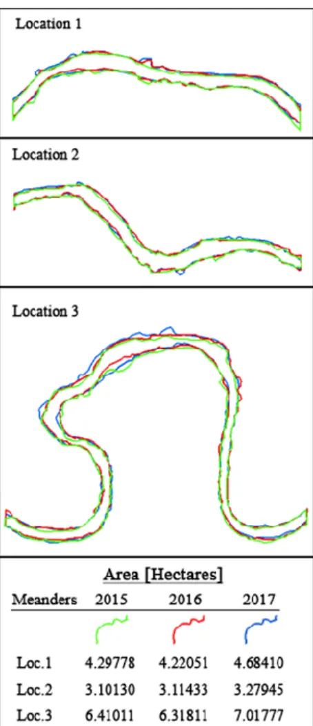
In this study, primarily, the changes in winter and spring seasons were investigated to determine the periodic sediment changes in the selected meandering fields of the Büyük Menderes Basin. The 3D surface models of the meanders of January and May were produced and the sediment quantities were calculated periodically. In addition, a multi-temporal model is needed to calculate the sediment transport information in the meanders. Results showed that UAV can provide a suitable measurement model in determining eroded/deposited sediment quantities along the meandering fields. Figure 3 shows the river shoreline changes of the selected locations, which were extracted by digitizing Sentinel 2A imageries from 2015 to 2017. Especially, riverbank erosion along the river can be determined by digitizing the edges and volumetric calculations of the eroded/deposited sediments derived from UAV-based measurements, in more detail.
In the scope of the study, the 3D point cloud data and the 3D surface models were generated for the meandering structures by providing the analysis of volumetric data between two different data models. Therefore, it has been examined whether the 3D dense point cloud can give a more accurate result than the interpolated 3D surface models.
Fig. 3River shoreline changes of the selected locations. In conclusion, it is estimated that UAVs will be used instead of conventional photogrammetry aircraft in many future projects, considering the data production times and costs in large areas. However, various digital cameras and sensors that can be mounted on UAVs are also predicted to be able to examine the sediment effect on the health and productivity of plants in agricultural areas around the meander.
5. REFERENCES
[1] S. Kabdaşlı, “Karasu Sahili Erozyon Probleminin İncelenmesi - Ön Değerlendirme Raporu”, İ.T.Ü. İnşaat Fakültesi, Su ve Deniz
Bilimleri ve Teknolojisi Uygulama ve Araştırma Merkezi, 2010.
[2] O. Ozcan, N. Musaoglu, D. Z. Seker, D. Z. “Environmental impact analysis of quarrying activities established on and near river bed by using remotely sensed data”, Fresenius Environmental
Bulletin, 21, 11,3147 – 3153, 2012.
[3] E. İrtem, S. Kabdaşlı, “Kıyı alanları yönetimi ile akarsu havzalarının yönetimi arasındaki entegrasyon. Türkiye‘nin kıyı ve deniz alanları”, III. Ulusal Konferansı Bildiriler Kitabı, 21-30, 2001.
[4] M. A. Fonstad, J. T. Dietrich, B.C. Courville, J. L. Jensen, P. E. Carbonneau, “Topographic structure from motion: a new development in photogrammetric measurement”, Earth Surface
Processes and Landforms, 38, 421–430, 2013.
[5] T. Niedzielski,, M. Witek, W. Spallek, “Observing river stages using unmanned aerial vehicles”, Hydrology and Earth System
Sciences Discussions, 10.5194/hess-2016-49, 2016.
[6] C. Flener, M. Vaaja, A. Jaakkola, A. Krooks. H. Kaartinen, A. Kukko, E. Kasvi, H. Hyyppä, J. Hyyppä and P. Alho, “Seamless mapping of river channels at high resolution using
mobile lidar and uav-photography”, Remote Sensing, ISSN 2072-4292, 2013.
[7] Ö.F Durdu, V. Cvetkovic, “Modeling water and nutrients fluxes in the Büyük Menderes drainage basin, Turkey”, Water Science &
Technology, 59: 531-541, 2009.
[8] A. Büke, M. Gültekin, A. Aksoy, B. Bahar Dıvrak, Ç. Göcek, M. Ö. Berke, H. Çeşmeci, “Büyük Menderes Havza Atlası”, World
Wildlife Fund-Turkey (Doğal Hayatı Koruma Vakfı),
978-605-62927-1-2, 2013.
[9] Çevre ve Orman Bakanlığı, “Büyük Menderes Nehir Havzası Yönetim Planı Nihai Taslağı”, Türkiye‘de Su Sektörü için Kapasite
Geliştirilmesi Başlıklı Avrupa Birliği Eşleştirme Projesi,
Tr06-IB-EN-01, 2007.
[10] N. Snavely, S. M. Seitz, R. Szeliski, “Modeling the world from internet photo collections”, International Journal of Computer
Vision, 80 (2), pp 189–210, 2007.
[11] D. Ierodiaconou, A. C. G. Schimel, “A new perspective of storm bite on sandy beaches using unmanned aerial vehicles”,
Zeitschrift für Geomorphologie, 60, pp 123–137, 2016.
[12] M. Mumbone, R. M. Bennett, M. Gerke, W. Volkmann, “Innovations in boundary mapping: Namibia, customary land and UAVs”, World Bank Conference on Land and Poverty, 2015.
7889
View publication stats View publication stats