by W. J. McCallien
Professor of Geology
Modern methods of travel over great distances make one ponder on the long struggles of the early pioneers, whom we so easily forget. Without these struggles our present methods and our present knowledge of the earth's surface would have been impossible. Sitting at an airport, such as London, one may speak to travellers to almost all parts of the world, waiting like oneself, for the minute of departure of an aircraft. A few hours later, the interrupted conversation may be rene-wed with the same travellers at Marseilles, and again at Rome, as the aeroplanes arrive and depart at intervals of a few minutes. At Rome, the routes are likely to diverge and in another few hours thousands of miles may separate the travellers. We can no longer think of our earth in terms of great distances, with great barriers separating the different parts. Distances have shrunk so much that it is now said there is no place on the surface of the earth which cannot be reached in sixty hours of flying, and this length of time is being reduced.
The aeroplane is only 45 years old. In 1903, on the sands at Kitty Hawk in North Carolina, two bravo men, the brothers Wright, were able to stay in the air, Orville for 12 seconds, and Wilbur for 59 seconds. In 1904, they were able to stay in the air long enough to travel 60 ft. , but the following year they could travel 20 miles. Nobody took much interest in these flights, but we know now that they were the beginning of one of the greatest revolutions in human progress.
Man has long been a traveller. In Prehistory there is plenty of evi-dence of the capacity of early man to travel considerable distances. During the interglacial periods of the İce Age, when climates were sometimes more genial than they are today in north-western Europe, palaeolithic man travelled far and wide over that continent. His imp-lements are now found below the deposits of the succeeding ice sheets or in the caves which were sealed by the readvance of the ice. These journeys of palaeolithic man were made in the search for food, and he followed the animals northward as the ice melted, and came south again with them as the climate deteriorated.
In the New Stone Age journeys were made for the express purpose of trade. For example, Neolithic trade in precious and semi-precious stones involved long journeys around the Mediterranean and beyond to the east and west. The evidence for these journeys
lies in the stones found in the early sites. The world of that time was largely between the Mediterranean and india but civilization soon spread. In the succeeding period discovery of how to smelt ores and mould metals spread much further afield. Travel took time in these early days and we find that the culture of north•western Europe lag-ged behind that of the Middle East. The propagation of techniques also took place comparatively slowly.
There are two aspects of earth knowledge which are closely related. One is the astronomical and deals with the progress of our knowledge of the earth's position in the universe as a whole. The other deals with the growth of our information on the earth itself. Let us consider very briefly the main milestones of astronomical history first and then return to the major discoveries of the distribution of land and sea on the earth's surface.
Astronomical history.
Prehistory and archaeology teach us that man was in the first place a hunter and a food gatherer. At a later stage, he was able to grow his food in a few specially favourable localities. He became a farmer. To be successful, any system of farming must be conducted with some knowledge of dates for, even in the most favourable river valley, there are only certain seasons when crops can be planted and the harvest reaped. If the traditions of the farmers are to be passed on so that the community may survive, then the best times for the vari-ous operations must be dated. This could only have been done by the phenomena of the skies. Numan attention was, therefore, early directed to the stars, the moon, and the sun. As long ago as 4000 B. C. the Egyptians had invented a calendar and they calculated the length of the solar year. Their calendar was the forerunner of later calendars, and they laid the foundations of mathematical astronomy.
Long before telescopes were invented the more obvious movements which took place in the sky, such as those of the sun and the pla-nets, were familiar to the early Greek philosophers. As was their habit, the philosophers developed theories to explain these movements. The theories culminated in Ptolemy's hypothesis, according to which the earth was fixed in the centre of the universe. The sun, the planets, and the other stars were alt believed to move round the earth. This hypothesis of the second century A. D. was accepted by philosophers until the 16 th. century. During that tong period there were only a few thinkers who lightened the darkness with their ideas. Pythagoras, in the 6th century B. C., is believed to have taught that the planets moved round the sun and his follower, Philolaus, taught that the earth was spherical and rotated on its axis once every 24 hours. The rotation of the earth, he said, was responsible for the phenomena
of night and day. İn the fourth century B. C. , Aristotle argued in favour of a spherical earth and even measured the obliquity of the earth's axis.
In the third century B. C. , Aristarchus of. Samos proposed the heli-ocentric theory of the solar system according to which the sun, not the earth, is the centre of the system. The earth was believed both to rotate on its axis and to revolve round the sun in a circular orbit.
In spite of the teachings of these few, however, the fixity of the earth and the Ptolemic version of the solar system was generally accepted.
Then a Polish monk, Copernicus (1473 - 1543), ushered in a new period of thought. He put forward the theory that the apparent daily movements of the heavenly bodies are due to rotation of the earth in a planetary system of which the sun is the true centre. An interesting feature of Copernicus' teachings was his demonstration that the earth must be round. His observations are commoplace in modern school-books, but at that time they represented a great advance. His simple observations were as follows :
a) the sun, the moon, and the stars are round :
b) water falling from the clouds, or molten lead from a tower, gathers into drops :
c) the highest parts of mountains, or of a ship, appear first when approached, and disappear last, when left behind
d) when seamen wish to see far they climb to the masthead e) during eclipses of the moon, the shadow of the earth is an
arc of a circle.
Another feature of the Copernican theory was based on an, equally simple and common observation. He referred to the fact that the sho-reline appears to recede from the sailor when he goes to sea, just as objects by the roadside appear to pass the traveller on land. So he applied these observations and concluded that the apparent revolution of the sun, the moon, and the stars westward around the earth was caused by the revolution of the earth itself on its own axis from west to east every 24 hours. To Copernicus it was the sun which was the centre around which the earth and the planets revolve.
Considering the time when Copernicus lived it was natural that many were greatly disturbed by the transfer of the centre of the solar system from the earth to the sun. The earth now became rather insignificant and no different from the other planets. İts status had changed from the most important star in the heavens to that of an ordinary planet under the complete control of another star. The teac-hings of the church in particular were now shown to be wrong in one matter of great importance. For various reasons attempts to suppress
the new views were necessary, but Copernicus had dedicated his work to the Pope and thereby delayed criticism and censure of his theory.
Copernicus' successor was Tyche Brahe (1546 - 1601). Brahe was a great astronomical observer but he rejected the heliocentric theory. His contemporary Giordano Bruno, however, taught that the earth was really a planet, and he was burned at the stake for his teachings in February, 1600.
With this crime a new period of thought and observation began. Galileo, in 1610, was able to make observations on the stars with his little telescope and one of his first discoveries was of a system resemb-ling the solar system as pictured by Copernicus. In that year he discovered the four brightest moons of Jupiter, a miniature solar system the movements of which gaye support to the Copernican theory. Per-haps they gaye more than support for it seemed to him that they actually established the truth of the theory. However, he was forbidden to publish his results or to teach what he thought. Ultimately he be-came blind.
However, Galileo's contemporary, Kepler, finally established the laws of planetary motion and laid the foundations of modern theories. Then followed Newton's law of gravitation (1666) and for the first time the planetary motions were explained by the force of universal gravitation.
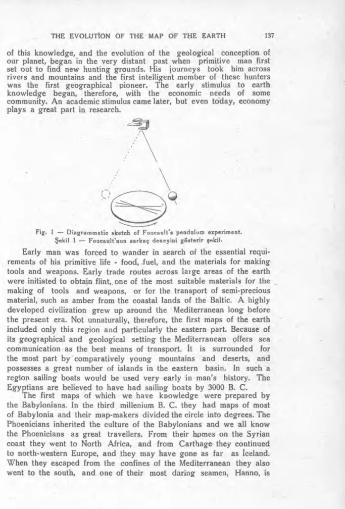
The actual demonstration of the rotation of the earth did not ma-terialize until 1851 when Foucault made his famous experiment from the dome of the Pantheon in Paris. There he suspended an iron ball by a wire more than 200 feet long. A pin projected from the lower side of the ball so that when the ball was set swinging the pin marked the surface of a tray of sand which played the part of the earth's surface. The object of the experiment was to see if the pin would continue to trace the same line, or if it would change its position with respect to the surface of the earth. Foucault found that the tray was slowy carried round beneath the pin. This experiment is stili made in many museums and it is always a centre of interest for both old and young. The rotation of the earth was thus proved and demonstrated.
This brief summary of astronomical history brings us to the modern period of astronomy with its great telescopes, its spectroscopes, its photographic equipment, and even its aeroplanes. The earth's position in the Universe was now known. The stage was set for filling in the details. Let us turn, therefore, to the more geographical aspect of the earth and consider the progress of our knowledge in this branch of science.
Geographical history.
of this knowledge, and the evolution of the geological conception of, our planet, began in the very distant past when primitive man first set out to find new hunting grounds. His journey s took him across rivers and mountains and the first intelligent member of these hunters was the first geographical pioneer. The early stimulus to earth knowledge began, therefore, with the economic needs of some community. An academic stimulus came later, but even today, economy plays a great part in research.
Fig. 1 — Diagrammatic sketch of Foucault's peadulum experiment. Şekil 1 — Foucault'nun sarkaç deneyini gösterir şekil.
Early man was forced to wander in search of the essential requi-rements of his primitive life - food, fuel, and the materials for making tools and weapons. Early trade routes across large areas of the earth were initiated to obtain flint, one of the most suitable materials for the making of tools and weapons, or for the transport of semi-precious material, such as amber from the coastal lands of the Baltic. A highly developed civilization grew up around the Mediterranean long before the present era. Not unnaturally, therefore, the first maps of the earth included only this region and particularly the eastern part. Because of its geographical and geological setting the Mediterranean offers sea communication as the best means of transport. It is surrounded for the most part by comparatively young mountains and deserts, and possesses a great number of islands in the eastern basin. In such a region sailing boats would be used very early in man's history. The Egyptians are believed to have had sailing boats by 3000 B. C.
The first maps of which we have knowledge were prepared by the Babylonians. In the third millenium B. C. they had maps of most of Babylonia and their map-makers divided the circle into degrees. The Phoenicians inherited the culture of the Babylonians and we all know the Phoenicians as great travellers. From their homes on the Syrian coast they went to North Africa, and from Carthage they continued to north-western Europe, and they may have gone as far as İceland. When they escaped from the confines of the Mediterranean they also went to the south, and one of their most daring seamen, Hanno, is
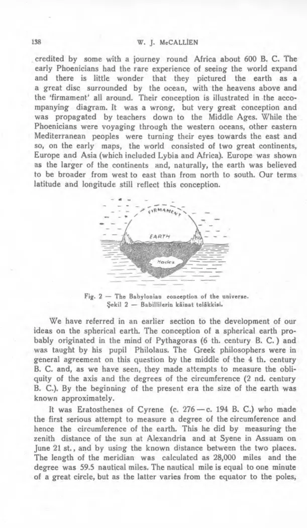
credited by some with a journey round Africa about 600 B. C. The early Phoenicians had the rare experience of seeing the world expand and there is little wonder that they pictured the earth as a a great disc surrounded by the ocean, with the heavens above and the `firmament all around. Their conception is illustrated in the acco-mpanying diagram. It was a wrong, but very gre
a
t conception and was propagated by teachers down to the Middle Ages. While the Phoenicians were voyaging through the western oceans, other eastern Mediterranean peoples were turning their eyes towards the east and so, on the early maps, the world consisted of two great continents, Europe and Asia (which included Lybia and Africa). Europe was shown as the larger of the continents and, naturally, the earth was believed to be broader from west to east than from north to south. Our terms latitude and longitude stili reflect this conception.Fig. 2 — The Babylonian conception of the universe. Şekil 2 — Babillilerin kâinat telâkkisi.
We have referred in an earlier section to the development of our ideas on the spherical earth. The conception of a spherical earth pro-bably originated in the mind of Pythagoras (6 th. century B. C.) and was taught by his pupil Philolaus. The Greek philosophers were in general agreement on this question by the middle of the 4 th. century B. C. and, as we have seen, they made attempts to measure the obli-quity of the axis and the degrees of the circumference (2 nd. century B. C.). By the beginning of the present era the size of the earth was known approximately.
It was Eratosthenes of Cyrene (c. 276 — c. 194 B. C.) who made the first serious attempt to measure a degree of the circumference and hence the circumference of the earth. This he did by measuring the zenith distance of the sun at Alexandria and at Syene in Assuam on June 21 st., and by using the known distance between the two places. The length of the meridian was calculated as 28,000 miles and the degree was 59.5 nautical miles. The nautical mile is equal to one minute of a great circle, but as the latter varies from the equator to the poles,
a mean value has to be accepted. The British Adn ıiralty uses 6080 ft. as the length of the nautical mile. In America it is longer and in France and Germany shorter. Before Eratosthenes, a Moslem geographer had calculated the length of a degree as 66.2 nautical miles. Obviously there were errors in the early calculations but the amazing thing is that so many of them cancelled one another to give these fairly good results.
A hundred years after Eratosthenes, Posidonius made another attempt to calcutate the length of the meridian. His results however were further from the truth than those of Eratosthenes, but they were
adopted by Ptolemy and they were accepted until the 15 th. century when the Portuguese and Spanish sailors became famous for their discoveries of many new lands. It is interesting to note that Posido-nius believed that India could be reached by sailing westward from Cadiz.
At this time a new problem presented itself. The size of the earth was known approximately but the habitable lands of Europe, Africa, and Asia were insufficient to cover the earth sphere. In fact they only covered a very small portion of it. It became customary, therefore, to add three extra continents to balance the known ones and this practice was followed for a long time af ter it was introduced in 150 B. C. One of the extra continents so introduced lay in the far south and was of great dimensions. It survived for 1700 years and finally was reduced in size to the present Antarctica.
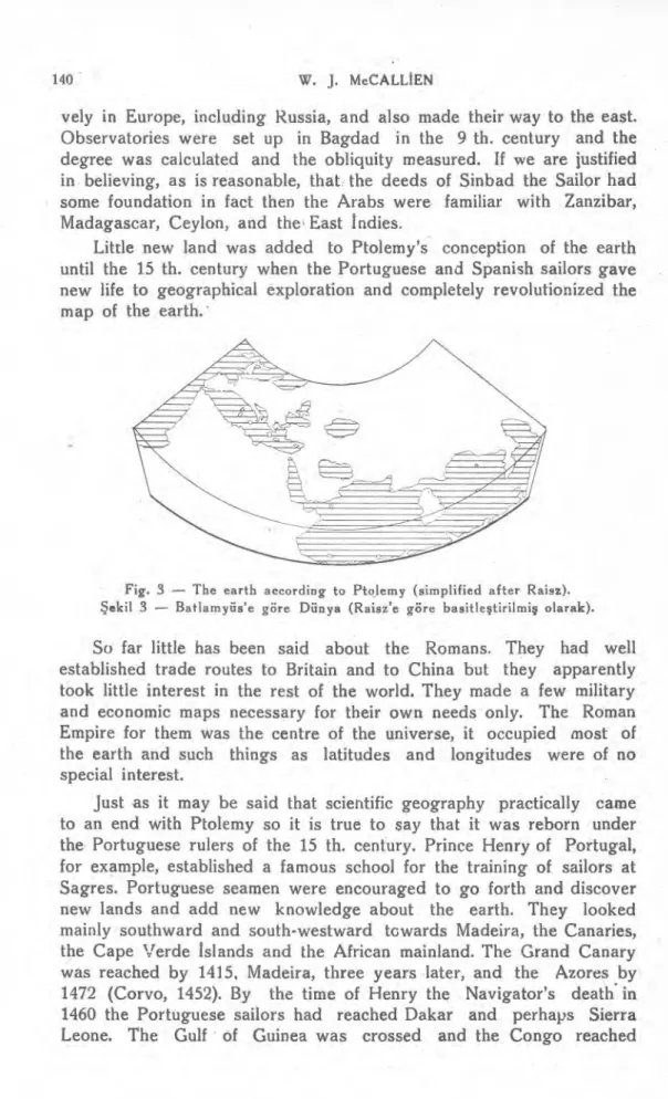
Ptolemy, we have said, exerted a great influence on ancient astronomy. His influence was no less pronounced on geography and his map of the earth gives a good idea of the earth of his time. Fig. 3 is a simplified form of this map. It includes Britain, as well as İreland and Denmark, and stretched as far east as China. İndia is very reduced in size and Ceylon is too large. South of the equator Africa turns eastward and joins up with China so that the İndian Ocean is shown as an enclosed sea.
We have talked about the sea-ways of the ancient world but we must also point out that in the early days the Greeks and later the Romans were familiar with the overland routes to the far east and the land-sea route to İndia. The latter offered a choice. One way was via the Persian Gulf and the other via the Nile and the Red Sea. Thereafter İndia could be reached by way of the northern shore of the Arabian Sea. One of the early Greek captains discoverd that by making use of the south-west monsoon on the outward journey, and the north-east monsoon on the return, it was quicker to cross the Arabian Sea directly out of sight of the land.
For some time after the fall of Rome the centre of culture shifted to the Arab countries of the Near East. The Arabs travelled extensi-
vely in Europe, including Russia, and also made their way to the east. Observatories were set up in Bagdad in the 9 th. century and the degree was calculated and the obliquity measured. If we are justified in believing, as is reasonable, that the deeds of Sinbad the Sailor had some foundation in fact then the Arabs were familiar with Zanzibar, Madagascar, Ceylon, and the , East İ ndies.
Little new land was added to Ptolemy's conception of the earth until the 15 th. century when the Portuguese and Spanish sailors gaye new life to geographical exploration and completely revolutionized the map of the earth.
Fig. 3 — The earth according to Ptolemy (simplified after Raisz).
Şekil 3 — Batlamyüs'e göre Dünya (Raisz'e göre basitleştirilmiş olarak).
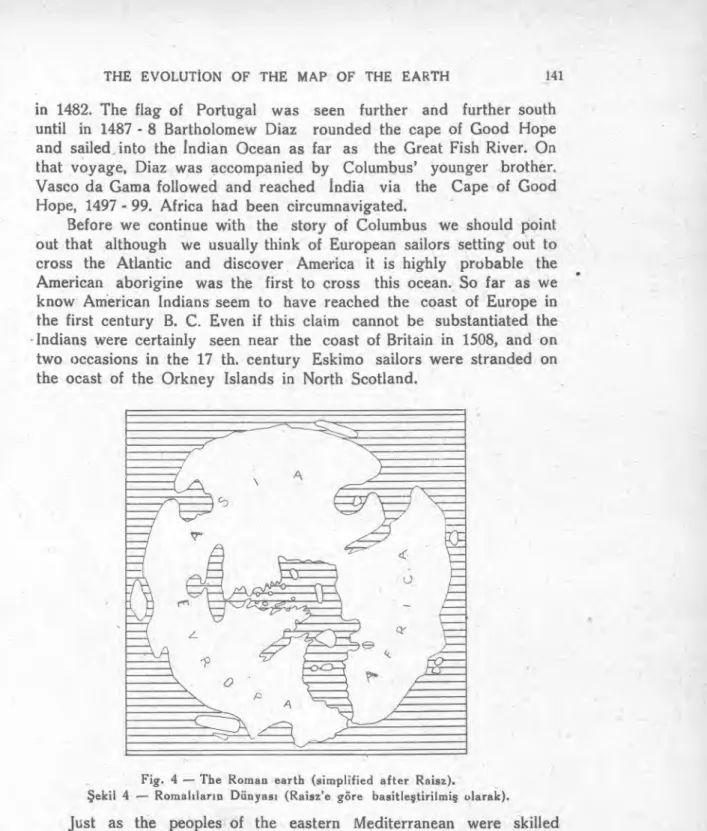
So far little has been said about the Romans. They had well established trade routes to Britain and to China but they apparently took little interest in the rest of the world. They made a few military and economic maps necessary for their own needs only. The Roman Empire for them was the centre of the universe, it occupied most of the earth and such things as latitudes and longitudes were of no special interest.
Just as it may be said that scientific geography practically came to an end with Ptolemy so it is true to say that it was reborn under the Portuguese rulers of the 15 th. century. Prince Henry of Portugal, for example, established a famous school for the training of sailors at Sagres. Portuguese seamen were encouraged to go forth and discover new lands and add new knowledge about the earth. They looked mainly southward and south-westward tcwards Madeira, the Canaries, the Cape Verde İslands and the African mainland. The Grand Canary was reached by 1415, Madeira, three years later, and the Azores by 1472 (Corvo, 1452). By the time of Henry the Navigator's death . in 1460 the Portuguese sailors had reached Dakar and perhaps Sierra Leone. The Gulf of Guinea was crossed and the Congo reached
in 1482. The flag of Portugal was seen further and further south until in 1487 - 8 Bartholomew Diaz rounded the cape of Good Hope and sailed into the İndian Ocean as far as the Great Fish River. On that voyage, Diaz was accompanied by Columbus' younger brother. Vasco da Gama followed and reached İndia via the Cape of Good Hope, 1497 - 99. Africa had been circumnavigated.
Before we continue with the story of Columbus we should point out that although we usually think of European sailors setting out to cross the Atlantic and discover America it is highly probable the American aborigine was the first to cross this ocean. So far as we know American Indians seem to have reached the coast of Europe in the first century B. C. Even if this claim cannot be substantiated the Indians were certainly seen near the coast of Britain in 1508, and on two occasions in the 17 th. century Eskimo sailors were stranded on the ocast of the Orkney Islands in North Scotland.
Fig. 4 — The Roman earth (simplified after Raisz).
Şekil 4 — Romanların Dünyası (Raisz'e göre basitleştirilmiş olarak).
Just as the peoples of the eastern Mediterranean were skilled seamen because the sea of fered the best means of communication, so the people of Norway also became great sailors for the same reason that travel among the fiords was best carried out by boat. The Nor-semen ventured far afield and soon after the middle of the 9 th. cen-tury they had discovered Greenland. In the 10 th. cencen-tury they had reached the coasts of North America and sailed southward as far as
Rhode Island. The history of their voyages and discoveries are recor-ed mainly in the Norse sagas but certain objects have been found in the neighbourhood of Rhode Island to corroborate the sagas.
Let us now return to Columbus. For some years he sailed under the Portuguese flag, but in 1492 his allegiance and the initiative passed to Spain. In Portuguese ships Columbus is believed to have reached İceland and he probably also sailed along the African coast. With his brother, Bartholomew, he had a chart-making business in Lisbon. Like most people of that day Columbus was aware that the earth was round. Many others were probably thinking along the same lines as himself, for if the earth was really round then it should be possible to reach Japan, China, and İndia by sailing westward across the ocean.
The great difficulty was to estimate the distance which would have to be covered by this western route. Colurnbus made a recalculation of the length of a degree and concluded that it was 45 nautical miles. That red uced the size of the earth from previous estimates. In addition using various arguments to increase the length of Asia he stretched it out until Europe and Asia together covered 283°. In this way he argued that by sailing westward from the Canaries he would only have 68° of ocean to traverse. The journey which he planned would be some three thousand nautical miles instead of some ten thousand. How much of this he believed it is impossible to say but one is inclined to think that he deliberately reduced the distances. Portugal, however, turned down the suggestion that he should sail west and so it was in a Spanish ship that he discovered the West indies in 1492. Columbus made four journeys across the Atlantic. The journeys were made by dead-reckoning, there was no celestial checking of position, instead of an accurate chronometer he had a sand - glass. His compass was apparently accurate for to his discomfiture Columbus discovered westerly variation and the rotation of Polaris about the true north. Columbus' discoveries were great by any standards but because he was a failure as a colonial administrator he returned to Spain in chains.
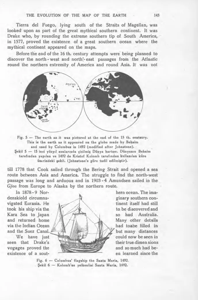
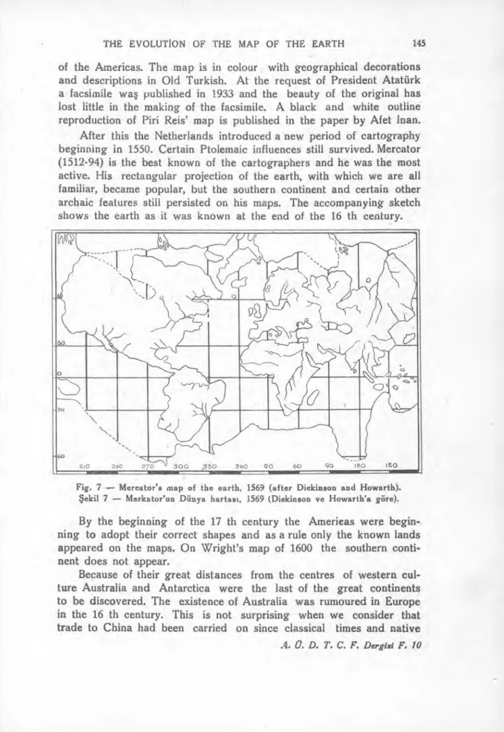
Columbus' conception of the earth is shown in Fig. 5 and his flagship in Fig. 6.
After this it was only a matter of time before the coasts of North and South America would be familiar to seamen and before one of them, more daring than the others, would round Cape Horn and so open the western route to the Pacific. This was done by Magellan, who passed through the straits now called after him, on November 28, 1520, and crossed the Pacific to the Philippines (March 16, 1521) where he was kil!ed. One of his ships, the Victoria, however, continued the journey under Sebastian del Cano and returned to Spain on April 8, 1522. The first circumnavigation of the earth had been accomplished.
Tierra del Fuego, lying south of the Straits of Magellan, was looked• upon as part of the great mythical southern continent. It was Drake who, by rounding the extreme southern tip of South America, in 1577, proved the existence of a great southern ocean where the mythical continent appeared on the maps.
Before the end of the 16 th. century attempts were being planned to discover the north - west and north'- east passages from the Atlantic round the northern extremity of America and round Asia. It was not
Fig. 5 — The earth as it was pictured at the end of the 15 th. centsury. This is the earth as it appeared on the globe made by Behaim
and used by Columbus in 1492 (modified after Johnstone).
Şekil 5 — 15 inci yüzyıl sonlarında çizilmiş Dünya hartası. Dünyanın Behaim tarafından yapılan ve 1492 de Kristof Kolomb tarafından kullanılan küre
üzerindeki şekil. (Johnstone'e göre tadil edilmiştir).
till 1778 that Cook sailed through the Bering Strait and opened a sea route between Asia and America. The struggle to find the north-west passage was long and arduous and in 1903 - 4 Amundsen sailed in the
Gjoa from Europe to Alaska by the northern route.
In 1878 - 9 Nor- hern ocean. The ima-
denskiold circumna- ginary southern con-
vigated Eurasia. He i tinent itself had stili
took his ship via the to be discovered and
Kara Sea to Japan so had Australia.
and returned home Many other details
via the Indian Ocean had toabe filled in
and the Suez Canal. but many distances
We have just could now be seen in
ı
ıi,\seen that Drake's iııjıı isl their true dimen sions
vogages proved the and so much had be-
existence of a sout- en learned since the
Fig. 6 — Columbus' flagship the Santa Maria, 1492. Şekil 6 — Kolomb'un yelkenlisi Santa Maria, 1492.
Portuguese sailors founded their island colonies that reasonably
accu-rate maps and charts could be produced.
At the end of the 15 th. century Germany appeared as an active
centre of map and globe making. Behaim's globe was the best of the
time, and may have been known to Columbus, for Behaim from
Nu-remberg was a member of the Portuguese Royal Maritime Commission
in 1484. After Columbus' return from his first voyage, Behaim
sug-gested that it might be possible to reach the East by sailing westward.
The distribution of land and sea on the map at this time is shown
in Fig. 6 Ceylon is stilll exaggerated at the expense of
İ
ndia and the
eastern coast of Asia reached almost to the then unknown western
coast of America.
In connection with the maps of this time I should like to refer
briefly to the work of the Turkish navigator and geographer Piri Reis.
My attention to this has been directed by my colleague Mrs Afet
Inan whose publication "Bir Türk Amirali : Un amiral, geographe Turc
du XVI sicle, Piri Reis, auteur de la plus ancienne carte de
l'Ame-rique„ i cotains fuller details. Yusuf Akçura has also described the
work of Piri Reis in a special brochure of the Turkish Historical
Society (1935).
Piri Reis' map was discoyered in 1929 when the palace of
Top-kapu,
İ
stanbul, was being turned into a museum and the existence of
the map was first made public in an article in the newspaper
Son Postaby
İ
brahim Hakk
ı
. The original complete map of the world must have
been a remarkable work judging by the portion which has survived.
In constructing it Piri Reis tells us that he used most of the maps
which were then available, including four by Portuguese explorers and
one by Columbus himself. The map was not only a compilation based
on these for the author was able to add much from his own wide
experience. It was entirely up-to-date and Piri Reis claimed that "In
this century there is no other map like this map in anyone's
posses-sion So that the present map is as correct and reliable for the
Seven Seas as the maps of these our countries are considered correct
and reliable by Seamen„ (translation in Akçura).
Piri Reis had a long record of service with the Turkish navy and
he took a great interest in the science of navigation. At one time the
had the title of Admiral of the Red Sea and the Arabian Sea. His
knowledge of the Mediterranean was particularly extensive.
The map with which we are specially concerned here was finished
at Gallipoli in 1515 and presented to the Sultan Selim I in 1517. The
portion which is preserved contains the Iberian peninsula, ihe western
bulge of North Africa, the Atlantic Ocean, and the coasts and islands
o
210 240 270 300 ,350 360 q0 60 90 120 150
of the Americas. The map is in colour with geographical decorations
and descriptions in Old Turkish. At the request of President Atatürk
a facsimile wa
ş
published in 1933 and the beauty of the original has
lost little in the making of the facsimile. A black and white outline
reproduction of Piri Reis' map is published in the paper by Afet Inan.
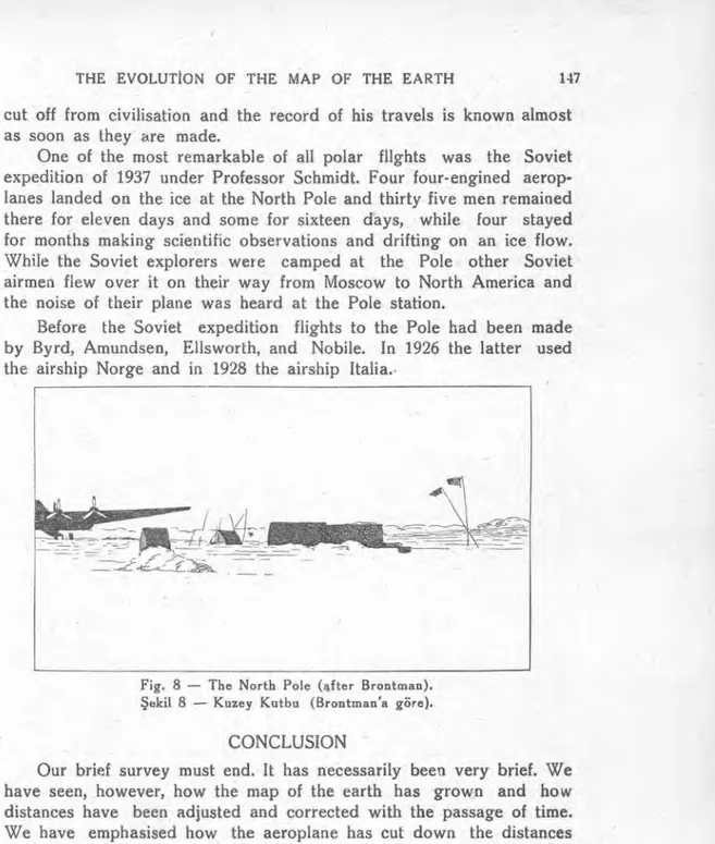
After this the Netherlands introduced a new period of cartography
beginning in 1550. Certain Ptolemaic influences stili survived. Mercator
(1512-94) is the best known of the cartographers and he was the most
active. His rectangular projection of the earth, with which we are all
familiar, became popular, but the southern continent and certain other
archaic features stili persisted on his maps. The accompanyin
ğ
- sketch
shows the earth as it was known at the end of the 16 th century.
Fig. 7 — Mercator's map of the earth, 1569 (after Dickinson and Howarth).
Şekil 7 — Merkator'un Dünya haftası, 1569 (Dickinson ve Howarth'a göre).
By the beginning of the 17 th century the Americas were
begin-ning to adopt their correct shapes and as a rule only the known lands
appeared on the maps. On Wright's map of 1600 the southern
conti-nent does not appear.
Because of their great distances from the centres of western
cul-ture Australia and Antarctica were the last of the great continents
to be discovered. The existence of Australia was rumoured in Europe
in the 16 th century. This is not surprising when we consider that
trade to China had been carried on since classical times and native
A. O. D. T. C. F. Dergisi F. 10Malay sailors probably reached Australia in the early days and may have brought back information to be passed on to the travellers from the west. The northern mainland of Australia was reached by a Dutch vessel in 1606 while it was trying to discover a short route to Java from the Cape of Good Hope. Other Dutch vessels explored the western coast. Tasman reached Tasmania and the northern İsland of New Zealand as well as Fili and some of the Tonga islands in 1644. Tasman also crossed the İndian Ocean between latitudes 45°S and 49°S in a search of the southern continent.
The following century was one of comparative inactivity.
This was brought to an end with the great voyages of Captain Cook which inaugurated the era of scientific exploration. Between 1772 and 1775 Cook crossed the Antarctic Circle and circumnavigated the globe in the region of 60°S latitude. He showed that New Zealand consisted of two islands, and so pushed the great southern continent of the old maps stili furrther to the south.
In 1819 the southern continent of Antarctica as we know it now was probably first seen by Bellingshauen who set out to follow in the wake of Captain Cook's journeys. The whaling and sealing industry developed in the southern ocean and many famous whaling skippers extended our knowledge of these inhospitable southern regions. N. B. Palmer in 1820 actually reached Antarctica and Palmer Peninsula is named after him. Since then many explorers have studied the Antarctic continent, men like Wilkes, Mawson, Shackleton, Scott, and Amundsen, Byrd and Ellsworth. It is sufficient for us here to recall that the South Pole itself was reached by Amundsen on December 14, 1911 and by Scott on January 18, 1912. According to Amundsen the Antarctic con-tinent rose to a height of 11,000 feet at latitude 88° S.
Let us turn for an instant to the north. Peary studied northern and north-eastern Greenland towards the end of the 19 th. century in the hope that he might be able to reach the North Pole by land. Nansen was also trying to reach the pole by drifting in his ship with the arctic current. He proved that the Arctic Ocean is comparatively deep and by making a sledge-journey from his ship he reached latitu-de 86°14' N. the highest latitulatitu-de reached till that time. Peary is belie-ved to have reached the pole in 1909 and to have demonstrated the complete absence of land and thus the fundamental difference between arctic and the antarctic.
With the entry of the aeroplane into polar exploration successful flights have been made across Antarctica and to both poles of the earth. Byrd has the honour of being the first to fly to the North Pole (1926) and to the South Pole (1929). The use of the radio in polar flights, as in all others, now enables the explorer to keep in touch, not only with his base, but with the people at home. He is no longer
cut off from civilisation and the record of his travels is known almost as soon as they are made.
One of the most remarkable of all polar flights was the Soviet expedition of 1937 under Professor Schmidt. Four four-engined aerop-lanes landed on the ice at the North Pole and thirty five men remained there for eleyen days and some for sixteen days, while four stayed for months making scientific observations and drifting on an ice flow. While the Soviet explorers were camped at the Pole other Soviet airmen flew over it on their way from Moscow to North America and the noise of their plane was heard at the Pole station.
Before the Soviet expedition flights to the Pole had been made by Byrd, Amundsen, Ellsworth, and Nobile. In 1926 the latter used the airship Norge and in 1928 the airship Italia.•
Fig. 8 — The North Pole (after Brontman).
Şekil 8 — Kuzey Kutbu (Brontman'a göre).
CONCLUSION
Our brief survey must end. It has necessarily been very brief. We have seen, however, how the map of the earth has grown and how distances have been adjusted and corrected with the passage of time. We have emphasised how the aeroplane has cut down the distances and made travel possible to places previously seen only by a few intrepid explorers, how the radio almost eliminates time, and we might have added also how the air-camera makes records of the earth's sur-face beneath the aeroplane, so that the construction of maps is now infinitely easiee than before. Our generation has grown familiar with flights round the earth in a matter of days. The Atlantic was flown for the first time in 1919, only 30 years ago. The journey was from west to east. It was not till 1928 that it was flown from east to west. The Pacific was flown by stages in 1928. Now the oceans are being
(<€,1482 Peorc.iy at Pole
ıqo Q'
'CS-rnS hule
o En r y corov apa rgftmt ae 5
Greekxs Romons
415 trode fo, si-ıkt
14 ,, 56 . ColumbuS c% 1492 c, o, Cab-ot 14q7 Q da Garna to I n dia 14q7 -9 1606 "- Pö • D ıa 3/ 1487-8 -'0 --...--- t-, ... O /ı İİ Drake ..,_ 1 5 77 -- Tosmo n 1644 Cook 1768 '71 Coptdcn Coo/s ctrcumı-lovugotes fhe e-orth 1772 -
Belltn9shousen see5 A nforctcca ısıq A mu.ndsen at S. %/e ıl- Dec 1911
crossed daily and nightly in a matter of hours. We read that the first non-stop flight round the earth has been made by an American plane in 94 hours. The route taken was from Forth Worth in the U. S. A. via the Azores, the Mediterranean, Arabia, İndia, the Philippines, and Hawaii. The distance flown without a stop was 23, 452 miles and the plane (Lucky Lady II) was commanded by Captain James Gallagher.
There have been many aspects of earth-exploration which we have not mentioned in this rapid survey. For example we have not spoken about the many attemps which have been made to reach the summit of Mt. Everest, the highest point on the earth's surface. There is still a great deal to do before our knowledge is complete. Our main object has been to recall the work of the pioneers so many of whom perished in their efforts to increase that knowledge.
Fig. 9 — $ketch map of the earth giving a general summary of the major disooveries.
— Hulâsa — Prof. Dr. W. J. McCallien
Uzun mesafelere seyahati mümkün kılan, süratli ve rahat modern taşıtlar ilk keşiflerin bugün kolayca unuttuğumuz mücadelelerini hatıra getirmektedir. Eğer bu mücadeleler olmasaydı biz bugünkü metotla-rımıza ve arz hakkındaki bilgimize sahib olmazdık. Bugün havacılık daha 45 yaşındadır. 1903 te North Carolina'da Kitty Hawk kumları üzerinde cesur Wright kardeşler ilkin 12, sonra da 59 dakika havada kalmağa muvaffak oldular. İki sene sonra da 20 mil uçtular, fakat insan medeniyetinde en mühim değişikliklere sebep olan bu uçuşlara pek ehemmiyet veren olmadı.
İnsan çok eski zamanlarda seyyahlığa başlamıştır. Prehistoryada ilk insanın uzun mesafelere seyahat etmek kabiliyetini haiz olduğunu gösteren deliller vardır. Buz çağında bazan kuzey-batı Avrupa'da iklimin belki bugünkünden daha ılık olduğu zamanlarda palelithic insan, oldukça geniş bir sâhada dolaşmıştır. Kullanmış olduğu aletler şimdi müteakip buz tabakalarının birikintileri arasında, yahut da buzların gerilemesiyle kapanan mağaralarda bulunmaktadır. Paleolithic insan bu gezilerini yiyecek bulmak için yapıyor, buzlar eridikçe hayvanların peşinde giderek kuzeye doğru çıkıyor ve sonra iklim bozulunca tekrar onlarla beraber güneye iniyordu. Yeni Taş devrinde seyahatlar ticaret maksadiyle yapılıyordu ve başlangıçta bunlar Akdeniz bölgesine mün-hasır kalmışlardı ; fakat sonraları demir eritim ve dökümcülüğünün keşfi ile ev velki devirlerden daha fazla yayılmak imkanı hâsıl oldu. O günlerde seyahat çok zaman alıyordu; ve bunun için Kuzey-Batı Avrupa kültürünün Orta Doğu kültüründen geride kaldığını görüyoruz. Teknik bilgi ve ihtiyaç maddeleri nisbeten yavaş yayılmıştır.
Arz hakkındaki bilgimizin şimdi bizi burada ilgilendiren, birbirine sıkı bir şekilde bağlı iki cephesi vardır. Bunlardan biri astronomiktir ki kâinatta arzın yerine ait bilgilerin inkişafı ile uğraşır. Diğeri ise bizim dünya hakkındaki bilgimizin ilerlemesine çalışır. Bunların her ikisi de burada gözden geçirilecektir.
Teleskopun keşfinden çok evvel güneşin ve gezeğenlerin gözle görünür bazı hareketleri eski filozoflarca biliniyordu. Her zaman yap-tıkları gibi filozoflar bu hareketleri de izah için teoriler kurdular. Niha-yet arzı kainatın ortasına koyan Pitolemi faraziyesi ortaya çıktı. Güneşin, gezeğenlerin ve diğer bütün gök cisimlerinin arz etrafında döndüğü zannedildi. İkinci asırda ortaya atılan bu teori 16 ncı asra kadar filo-zoflarca kabul edildi. Fakat bu uzun devirde hüküm süren karanl ığı kendi
fikirleri ile aydınlatan birkaç bilgin vardı. Pythagoras ve Phil o-1 a u s, gece-gündüz hâdisesini dünyanın kendi dönüşüne atfettiler. M. E. 3 üncü asırda Samos'lu A rist ar c h u s arzın değil, güneşin merkezde olduğunu' ve arzın hem kendi mihveri ve hem de güneş etrafında dön-mekte olduğunu iddia etti. Birkaç itiraza rağmen arzın sabit oluşu fikri ekseriyetle kabul edilmişti.
Bundan sonra yeni bir fikir cereyanı yaratan C o p e r n i c u s (1473- 1543) oldu. O, gezeğenlerin günlük hareketlerinin, arzın güneşi merkez olarak alan bir gezeğenler sistemi içinde yaptığı devirlerden ileri gel-diği fikrini ileri sürdü. Şimdi onun müşahedeleri ehemmiyetsiz gibi görü-nür, fakat zamanında onlar büyük bir terakki sayıldı. Copernicu s'un yaşadığı devri nazarı itibara alırsak bunun birçok kimseleri kızdırmış olmasını tabii görürüz. Arz, artık ehemmiyetini kaybediyor ve diğer gezeğenlerden farksız bir hale geliyor, en ehemmiyetli bir yıldız olmak-tan çıkarak, diğer bir yıldızın kontroluna tâbi alelâde bir gezeğen olu-yordu. Birçok sebeplerden dolayı yeni fikirlerin men edilmesine çalışıldı.
1610 da Galileo küçük teleskopu ile müşahedeler yapmağa başladı ve yaptığı keşiflerden birincisi Cop er n i c u s'un tarif etti ği sisteme benzer bir güneş sisteminin mevcudiyeti oldu. Copernicus teorisi'nin doğ ru-luğu anlaşılmıştı, fakat Galil e o vardığı neticeleri ve düşüncelerini bas-maktan menedildi. Galileo ile ayni devirde yaşıyan K epler nihayet gezeğenlerin hareket kanunlarını bularak bugünkü teorilerin temelini atmış o 1 d u. 1666 da N e w t o n, cazibe kanununu buldu. Arzın güneş etrafında dönüşü ancak 1851 de F oucault 'nun Pantheon kulesinden yaptığı tecrübe ile bilfiil isbat edildi.
Astronominin geçirdiği safhaların bu kısa hulasasından sonra, büyük teleskoplar, spektroskoplar, fotoğraflar ve hatta uçaklarla mü-cehhez modern astronomiye geliriz. Artık dünyanın kâinattaki yeri an laşılmış ve teferruatın yerli yerine konması için esas yapı kurulmuştur. Bugün baktığımız dünya haritası malümatla doludur. Bu bilginin top-lanması ve arzın jeolojik kavramının evrimi ilk insanların yeni avlanma sahaları aramağa çıktıkları çok eski zamanlarda başlar. Nehirler ve dağlar aşıp giden bu avcıların en kabiliyetlilerini ilk kaşiflerden say-mamız icabeder. Demek ki arz bilgisine doğru ilk hareket bir cemiye-tin ekonomik ihtiyacı ile başlıyor. Akademik ilgi daha sonra geliyor; bugün bile ekonomi ilmi araştırmalarda büyük bir yer almaktadır.
M. E. üçüncü bin yılda Babilliler Babilonya'nın büyük bir kısmının haritasına şahiptiler ; daireyi derecelere ayıran onların haritacılarıdır. Fenikeliler coğrafyayı Babillilerden öğrendiler ve bugün biz onların ne kadar çok seyahat etmiş olduklarını biliyoruz. Bunlar Suriye kıyıları n-daki memleketlerinden kalkarak Kuzey Afrika kıyılarına gitmişler ve oradan da Kuzey Avrupa ve belki de Izlanda'ya kadar çıkmışlardır. Bir kerre Akdeniz'in dar muhitinden kurtulunca güneye gittiler ; ve baz ı ce-
sur gemicilerin Afrika'yı bile dolaştığı söylenmektedir. Fenikeliler dün- yanın gittikçe genişlediğini fark ettiler ve arzı gök ve Okyanusla çev- rili büyük bir disk zannettiler. Bu yanlış fikir ortaçağlara kadar sürdü. Diğer bazı Akdeniz milletleri doğuya döndüler, ve böylece ilk harita- larda dünya Asya (Afrika ve Libya'yı da ihtiva etmek üzere) ve Avru- pa'dan ibaret idi. Bu haritalarda Avrupa daha büyük gösterilmiş ve dünyanın doğudan batıya, kuzeyden güneye olduğundan daha geniş olduğuna inanılmıştı. "Arz„ ve "Tül„ tabirleri hâlâ bu fikri gösterirler.
Arzın büyüklüğünü hesap etmek için ilk teşebbüslere girişen Cyren'li Er at o s t h e n e s (takriben M. E. 276-194) olmuştur. Meridyenin uzunluğu 28.000 mil ve derecesi de 59.5 deniz mili olarak bulundu. Daha evvel bir Islâm coğrafyacısı bunu 66.2 deniz mili olarak hesap- lamıştı. Tabiatiyle bu ilk hesapların hepsinde hatalar vardı, fakat işin tuhaf tarafı bu hesaplardan herbirinin evvelkilerini hükümsüz bırakacak neticeler vermesiydi.
15 inci asırda İspanyol ve Portekiz gemicileri yeni topraklar keş -fetmekle şöhret bulmuşlardı. O zamanlar dünyanın takribl büyüklüğü biliniyordu, fakat Asya, Avrupa ve Afrika'nın bilinen oturulur yerleri dünya yuvarlağını örtmeğe kâfi değildi. Onun için bilinen kıtalara karşı muvazeneyi tesis için 3 tane daha kıta ilâve etmek âdet oldu. İlk defa M. E. 150 de tatbik edilen bu usul çok sonralara kadar devam etti. Bu kıtalardan biri çok büyük olup güneyde bulunuyordu. Üzerinde 1700 sene geçtikten sonra nihayet bu kıta küçülerek şimdiki Güney Kutbu (Antarctica) oldu.
Pitolemi 'nin fikirleri yalnız eski astronomiye değil, ayrıca coğ raf-yaya da tesir etti ve onun dünya haritası zamanının dünyası hakkında iyi bir fikir vermektedir. Resim bu haritanın basitleştirilmiş bir şeklini gösteriyor.
Şimdiye kadar eski dünyanın deniz yollarından bahsettik ; şimdi de Yunanlıların ve daha sonra da Romahların Uzak Doğu'ya giden kara ve Hind'e giden kara • deniz yollarını bildiklerini işaret etme-liyiz. Roma yıkıldıktan sonra medeniyet merkezi Yakın Doğu'ya geçti; seyyahlar buradan uzak memleketleri keşfe çıktılar. Observatuarlar ku-ruldu ve arz ölçüldü. Fakat ancak 15 inci asırda Pitolem i'nin haritasına yeni karalar ilâve edildi. Portekiz ve İspanyol gemicileri dünya harita-sını tamamiyle değiştirdiler. Portekizliler başlıca güney ve güney batıya dikkatlerini çevirdiler ve 1482 de Congo'ya vardılar. Birkaç sene sonra Portekiz bayrağı Ümit Burnu'nu dönmüş, asır daha sona ermeden de Afrika devredilmiş ve Hindistan'a varılmıştı. Nasıl, denizin temin ettiği taşıyıcılıktan faydalanan Akdeniz milletleri mâhir denizci olmuş -larsa, Norveçliler de gemicilikte şöhret aldılar; çünkü fiyordlar arasında ulaştırma gemilerle oluyordu. Norslar derhal işe başladılar ve 9 uncu asrın yarısından hemen sonra Greenland'ı buldular ve onuncu asırda da Kuzey. Amerika kıyılarına vararak güneyde Rhode Island'a kadar indiler.
Colombus, birkaç sene Portekiz bayrağı altında gemicilik etti, fakat 1491 de İspanyol tabeası olarak Ispanya'ya hizmet etmeğe başladı. Por-tekiz gemileri ile Colombu s'un İzlanda'ya vardığı rivayet edilir. Zama-nının birçok kimseleri gibi o da dünyanın yuvarlak oluşunun farkında idi. Karşılaşılan en büyük güçlük mechul denizlerde mesafe tahmini idi. C olombu s, meridyen derecesini tekrar hesapladı ve 45 deniz mili ola-rak buldu, birçok sebepler göstererek Asya'yı biiyülttü, ve nihayet Ka-narya Adaları'ndan hareket ederse yalnız 68 derecelik bir okyanus parçası geçmek zorunda kalacağını söyledi. Fakat Portekiz onun batıya giderek Asya'ya varabileceği hakkındaki iddiasını reddetti, ve böylece Batı Hind Adaları 1492 de bir İspanyol gemisi ile keşfedildi. C olombus mevki tayini için yıldızlardan faydaları maksızın, hassas kronometreler yerine bir kum saati kullanarak, parekete seyri ile dört defa Atlanti ği geçti. Onun keşifleri ölçü ne olursa olsun, büyüktür ; fakat müstemlekecilikte muvaffak olamadığı için Ispanya'ya zincire vurularak getirilmiştir.
Bundan sonra Kuzey ve Güney Amerikaların bulunması bir zaman meselesi idi. 1520 de Ma gella n, şimdi kendi adı ile anılan boğ az-lardan geçerek Güney Amerika'nın güney ucunu dolaştı. Her ne kadar kendisi Filipinler'de öldürülmüş ise de, gemilerinden biri Ispanya'ya döne-bildi ve böylece dünya ilk defa devredilmiş oldu. 1577 de Darke, Güney Amerika etrafında dolaşarak güneye inmiş ve orada haritalarda hayali bir kıtanın gösterildiği yerde büyük bir okyanusun bulunduğunu gös-termiştir. Bu hayali kıt'a ve Avustralya hâlâ keşfedilmemişti. Daha bu-lunması lâzımgelen birçok teferruat vardı, fakat artık mesafeler daha sıhhatli bir şekilde ölçülebiliyor ve oldukça doğru haritalar yapı la-biliyordu.
Almanya bir zaman faal bir haritacılık merkezi olduktan sonra, Felemenk bu yolda yeni bir çığır açtı. Mercator (1512-94) haritacılığın en faal ve en meşhur şahsiyetidir. Onun bugün hepimizin bildiği mus-tatil inkişafı çok beğenildi, fakat güneydeki o eski kıt'a ve bazi eski hususiyetler hâlâ devam ediyordu. 17 nci asrın başlangıcında Amerika-lar hakiki şekillerini almağa başlamışlardı; o zaman yalnız bilinen kı t'a-ları göstermek âdet olmuştu. Bunun için Wright 'ın 1600 da çıkan haritasında artık güneydeki o büyük hayali kıt'a görülmez.
Avustralya ve Antarctica dünya haritasına eklenen son kara parçaları idi. Avustralya'nın mevcudiyeti 16 ncı asırda Avrupa'da şayia halinde dolaşıyordu ve bir Felemek gemisi 1606 da bu kıt'anın kuzey kıyılarına bile varmıştı. Bundan sonra uzun bir hareketsizlik devri geldi; fakaf bu devir 1772 ve 1775 senelerinde C o o k 'un yaptığı seyahatlarla sona erer. C o ok, Antarctic dairesini geçerek 60° güney arzında dünyayı devretti ve Yeni Zeland'ın iki adadan ibaret olduğunu gösterdi. Böy-lece eski haritalarda gösterilen büyük Güney Kıt'asını biraz daha güneye attı. 1819 da Güney Kıt'ası belki ilk defa olarrak C o o k 'un izinde yürü-yen B el 1 i n h a u s e n tarafından görüldü. Güney okyanusunda balina
avcılık' inkişaf etti ve balina avlıyan birçök gemiler bizim bu ıssız bölgeler hakkındaki bilgimizi genişletmeğe yardım ettiler. 1820 de Palmer, bilfiil Antarctica'ya varmağa muvaffak oldu. O zamandan beri W i 1 k e s, Mawson, Shackelton, Scott, Amundsen, Byrd ve Ell s-worth gibi birçok meşhur kâşifler Antarctica'yı tetkik ettiler.
Uçakların kutup keşiflerinde muvaffakiyetle kullanılışı sayesinde her iki kutba da uçuşlar yapıldı. Byrd, Kuzey (1926) ve Güney (1929) Kutuplarına ilk uçmak şeref ini kazanmıştır. Radyo sayesinde kutup kâşifleri yalnız üsleri ile değil, evleri ile bile irtibat tesis edebilmekte-dirler. Kâşif artık medeniyetten tecrit edilmemektedir. Neslimiz artık bir-kaç gün içinde dünya etrafında yapılan uçuşlara ve gece gündüz bir-kaç saat içinde büyük okyanusların aşılmasına hayretle bakmamaktadır.
Dergimizin bu sayısındaki iki makalemin Türkçeye çevrilmesi, şekillerinin çizilmesi hususlarında gösterdikleri yardımdan dolayı Asistan Ahmed Edib U y s a I'la Doçent Dr. Cevad Gürsoy ve Doçent Dr. Mu-zaffer Şen yürek 'e teşekkür ederim.