©BEYKENT UNIVERSITY
HYDROGEOLOGICAL INVESTIGATION OF
THE BEYAZSU AND KARASU SPRINGS AND
DETERMINATION OF THEIR PROTECTION
ZONES, SOUTHEASTERN ANATOLIA, TURKEY
Bahattin ÇETİNDAĞ ve Özlem ÖZTEKİN OKAN
University of Fırat1, Faculty of Engineering2Department of Geology 23119 Elazığ/ TURKEY e-mail: [email protected]
University of Fırat, Faculty of Engineering Department of Geology 23119 Elazığ/ TURKEY
e-mail: [email protected]
Received: 08 February 2008, Accepted: 15 February 2008
ABSTRACT
The study area is located at the 25 km NE of the city of Mardin. The basement is represented with lower Eocene Gercüş formation and the limestone of the Eocene Midyat formation. Discharge rates of the Beyazsu and Karasu springs were measured in a long-term time span. The amounts of water discharged by the Beyazsu spring during the 15 June-1 November 2003 and 1 June-1 November 2004 periods are calculated as 6.33x 10⁷ m3 and 6.53x 10⁷ m3, respectively. Likewise, the amounts of water discharged by the Karasu spring during the 1 June-1 November 2003 and 15 June-15 November 2004 periods are found as 3.49x 10⁷ m3 and 3.07x 10⁷ m3, respectively. Karstification is well developed within the limestone of the Midyat formation that feeds the springs and its mode of formation is controlled by fault and fracture systems. Units of the Gercüş formation at the base of the Midyat limestone comprise the impermeable basement for the aquifers in the region. Three different zones were determined as the protection sites for the springs.
Key Words: Beyazsu spring, Karasu spring, Midyat, Turkey, Karst, Protection
Bahattin ÇETİNDAĞ - Özlem ÖZTEKİN OKAN
BEYAZSU VE KARASU KAYNAKLARININ
HİDROJEOLOJİ İNCELEMESİ VE KORUMA
ALANLARININ BELİRLENMESİ, GÜNEYDOĞU
ANADOLU, TÜRKİYE
ÖZET
İnceleme alanı Mardin ilinin 25 km KD'sunda yer almaktadır. Bölgede temelde Alt Eosen yaşlı Gercüş formasyonu, üzerinde ise Eosen yaşlı Midyat formasyonuna ait kireçtaşları yer almaktadır. Bayazsu ve Karasu kaynaklarının uzun süreli debi değişimleri ölçülmüştür. Beyazsu kaynağının 15 Haziran- 1 Kasım 2003 tarihleri arasında boşalım kotu üzerinde boşalttığı su miktarı 6.33x
107 m3; 1 Haziran- 1 Kasım 2004 tarihleri arasında boşalım kotu üzerinde boşalttığı su miktarı ise 6.53x 10⁷ m3 olarak hesaplanmıştır. Karasu kaynağının 1 Haziran- 1 Kasım 2003 tarihleri arasında boşalım kotu üzerinde boşalttığı su miktarı 3,49x 10⁷ m3; 15 Haziran- 15 Kasım 2004 tarihleri arasında boşalım kotu üzerinde boşalttığı su miktarı ise 3.07x 10⁷ m3 olarak bulunmuştur. Kaynakları besleyen Midyat formasyonuna ait kireçtaşlarında karstlaşma yüzeyde ve derinlerde oldukça iyi bir şekilde gelişmiş olup bunlar fay ve kırık sistemleri ile denetlenmektedir. Midyat formasyonuna ait kireçtaşlarının tabanında bulunan Gercüş formasyonuna ait birimler bölgedeki akiferler için geçirimsiz temeli oluşturmaktadır. Kaynakların korunma alanları üç kuşak olarak belirlenmiştir.
Anahtar Kelimeler: Beyazsu kaynağı, Karasu kaynağı, Midyat, Türkiye, Karst,
INTRODUCTION
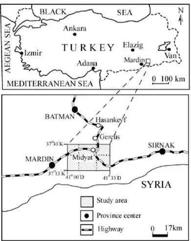
The investigation site comprises an area of 1500 km2 and it is located 370 13/ N, 370 30/ N latitudes and 410 00/E, 41033/E longitudes (Fig. 1).
Figure 1. Location map of the study area.
The region is located in the Southestern Anatolia and it is governed by a third degree, hot-less humid mesothermal climate. Water shortage during the summer time and water excess during the winter period are the most important features of this climate. Therefore, with respective discharge rates of 4.10-5.95 m3/sec and 1.75- 3.25 m3/sec, the Beyazsu and Karasu springs are very important for the region. The springs are the main water sources for large populations and for agricultural areas at the region. The Southeastern Region of Anotolia is mostly outcroped by karstic limestone and therefore there is no surface runoff at this region. Recharge of the springs occurs from a wide area. The catchment area of the springs is 1016,5 km2 and the 15 years' mean precipitation of the region is 590,5 mm. The main purpose of this research is to
Bahattin ÇETINDAG - Ozlem OZTEKÎN OKAN
study discharge of the Beyazsu and Karasu springs and karstification in limestone as well as to determine protection zones of the springs.
Since most of the oil reserves and phosphate deposits are located in southwestern Anatolia, various studies were conducted in the region which provided important information for geology and hydrogeology for the region
[1], [2], [3], [4], [5], [6], [7], [8], [9], [10], [11], [12].
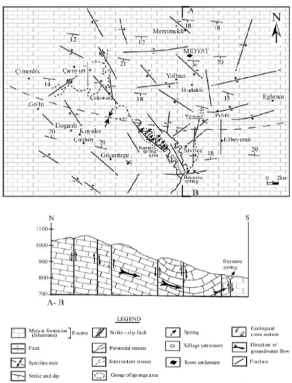
2. GEOLOGY
Eocene Midyat formation and Quaternary alluvium deposits are outcrop in the study area (Fig. 2).
The Gercüş formation, which overlies the upper Cretaceous units an angular unconformity outside the study area, comprises the impermeable basement of the aquifer in the Midyat formation. The Gercüş formation is composed of marl, clay, mudstone, conglomerate and shale-limestone units.
Limestone of the Midyat formation is widely exposed in the area. The unit is finely crystalline, compact, light beige colored and medium to thick bedded. In some places, it is chalky and white chalk levels are thick bedded. Chalky parts are generally soft. In northern section of the area, gray-cream colored dolomitic limestone are observed and their thickness changes between 300-400 m. White-yellow-black colored dolomitic, nummulitic and massive limestone are detected in the southern part. Their thickness is about 350-400 m.
Chalky limestone and gray-cream colored limestone is observed around Midyat. The measured thickness of limestone is about 300 m [10]. In the study area, alluvium with little thickness is found within the riverbeds. They are generally composed of clay, silt, sand and pebbles.
In the study area, which is located on border folds in the southeastern Anatolia, E-W trending folds have been formed due to movement of Arabian plate [10]. There are many faults developed in association with tectonic activity in the area.
3. HYDROGEOLOGY
3.1. SPRINGS
The Beyazsu spring issues from an E-W trending fault. The discharge of spring is 4.10-5.95 m3/sec. The Karasu spring emerge from several localities along a NW-SE trending fault. Its discharge rate is 1.75- 3.25 m3/sec. Both springs are typical fault springs and are fed by limestone of the Midyat formation. In the association with tectonic activity in the region, numerous fault and fracture systems have been developed in the Midyat limestone. As a result, advanced karstification is observed which gave rise to development of hydraulic conductivity in rocks. Units of the Gercüş formation comprise the impermeable basement of karstic limestone aquifer, which feeds the springs. The method of determining groundwater to springs is by direct measurement. Water levels of Beyazsu spring have been measured at gauging scales near the spring, continuously. But, the conbined flow of the group of the Karasu spring has been measured at a gauging scale some 40 to 50 m downstream the eyes of the spring. The registration of water levels of Karasu spring is continuously, either.
Bahattin ÇETINDAG - Ozlem OZTEKÎN OKAN
3.2. LONG-TERM DISCHARGE CHANGE
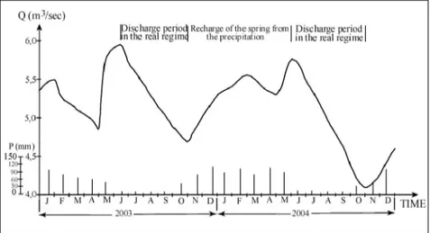
The changes in discharge rates of the Beyazsu and Karasu springs during the 1 January 2003 and 1 January 2005 period were examined with two different measurements for per month. Examination of Q = f (t) graphics for the springs reveals the presence of discharge period in real regime for both springs (Figs. 3 and 4). The Beyazsu spring is fed by precipitation during the 1 November 2003-1 June 2004 period while Karasu springs is fed during the 1 November 2003-15 June 2004 period.
Figure 3. The graph illustrating the variations in the discharge of Beyazsu Spring with precipitation and time.
Figure 4. The graph illustrating the variations in the discharge of Karasu Spring with precipitation and time.
3.3. CALCULATION OF DISCHARGE COEFFICIENTS
AND INTERPRETATION
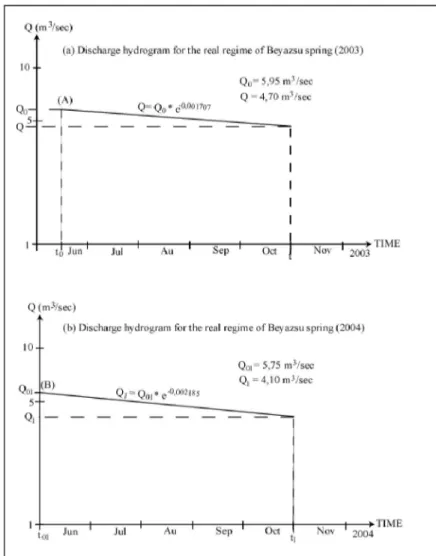
The first and second discharge periods in real regime for the Beyazsu spring are 15 June 2003-1 November 2003 and 1 June 2004-1 November 2004, respectively. Discharge rate of this spring during these periods were obtained from t and t0 times from the Q = f (t) graphic (Fig. 5). The general equation of the curves obtained is given as a commonly used exponential function proposed by Maillet [13].
Bahattin ÇETİNDAĞ - Özlem ÖZTEKİN OKAN
Q= Q0* e-a (t- t0) Where;
Q = discharge at time t (m3/sec)
Q0 = discharge at time to that is discharge at the beginning of real regime (m3/sec)
a = discharge coefficient (day-1)
t- t0 = time elapsed since the beginning of discharge (day)
The discharge between are 15 June 2003 and 1 November 2003 periods is represented with a curve. The beginning discharge is 5.95 m3/sec and that of after time t is 4.70 m3/sec. The discharge coefficient, a, is calculated from the following equation:
a = log Q0- log Q / (t- t0)* log e a1B is found as 1.707*10-3 day-1.
The second discharge coefficient of the Beyazsu spring during the 1 June 2004 and 1 November 2004 period is calculated as a2B= 2.185*10-3 day-1.
The first and second discharge periods in real regime for the Karasu spring are 1 June 2003-1 November 2003 and 15 June 2004-15 November 2004, respectively. The discharge coefficients calculated for these periods are
a1K=2.843*10-3 day-1, a2K=3.524*10-3 day -1 (Fig. 6).
3.4. STORAGE CAPACITY OF SPRINGS
Water storage capacities of the springs in their real regimes were calculated with the integration of Maillet (1905)'s [14] equation.
V0= (Q0/ a)* 86400
From the equation given above, storage capacity (V01) of the Beyazsu spring during the first discharge period between 15 June 2003 and 1 November 2003 is computed as 3.01x 10⁸ m3. Storage capacity (V2) of this spring in the real regime between 15 June 2003 and 1 November 2003 is found from the following equation as 6.33x 10⁷ m3.
V2= (Q0- Q/ a)* 86400
Storage capacity of the Beyazsu spring during the second discharge period (V01) between 1 June 2004 and 1 November 2004 is found as 2,27x 10⁸ m3. Storage capacity (V2) of this spring in the real regime between 1 June 2004 and 1 November 2004 is calculated as 6.53x 10⁷ m3. Storage capacity of the
Karasu spring (V01) on 1 June 2003 was measured as 9.88x 10⁷ m3. Storage capacity (V2) of this spring in the real regime between 1 June 2004 and 1 November 2003 is calculated as 3.49x 10⁷ m3. Storage capacity of the spring in the real regime during the second discharge period on 15 June 2004 is calculated as 7.36x 10⁷ m3 and storage capacity between 15 June 2004 and 15 November 2004 is found to be 3.07x 10⁷ m3.
Q (m\sci>!)
l<}--(a) Dj^chiir^c hydro trani fa" the real rc^im c of Kjiriisu spi inji t y Qj •- 3,25 mJ/ j c c
q 2J0n*Vsec
Jun Jul An Cfc
(ti) Dtichtfgc hydrogram ft* the real reyiqae of Karasu spring (2004) 1 0 " •
<¿01 3.00 nr' Ql I ^ S n A ' s e t
(B)
Q f l l - '
Jun^] 1 Jul 1 An ' S e p1 Oc ' N o v ' t ,t ^ —<N(iV> 1t - r a r T i M E 1 2004 iivb.i Figure 6. The discharge lines of Karasu spring in real regime.
Bahattin ÇETİNDAĞ - Özlem ÖZTEKİN OKAN
4. KARST FORMATION
Karst formation in the study area has been developed in association with lithology, tectonic and geographic factors as well as movement of ground and surface waters. Karstification in fractured carbonate rocks develops in various stages and is controlled by tectonism and bio- and physico-chemical factors [15].
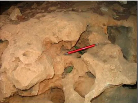
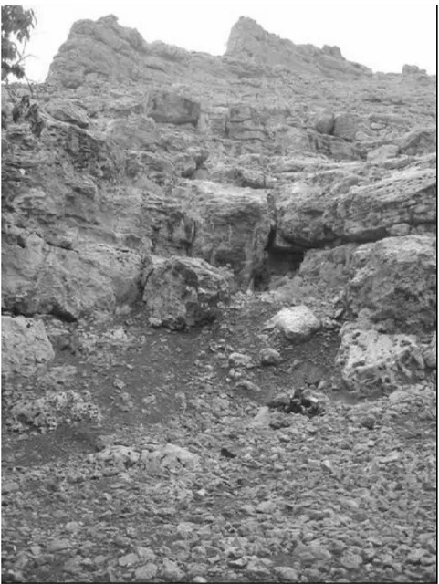
Fractures and faults controlled by the karstification is well developed on surface and within the finely crystalline, compact, beige colored limestone of the Midyat formation. Various types of clints are observed at the surface while the structures such as karstic voids and caves are seen at depths. The size of dissolution pans of the clints at the surface changes from a few cm to a few m and their depth is between a few mm and 50-60 cm. They are generally formed by dissolution of rocks, which have horizontal bedding (Fig. 7). Dissolution pans on the fractures systems are mostly observed as groups. In the region, chute like structures are developed on the dolomitic limestone (Fig. 8). Their width vary between 10-15 cm and depth is about 50-60 cm. Their length is as much as 2-3 m.
Other types of karstic occurrences shown in finely crystalline, compact, fragile limestone of the Midyat formation are caves and karstic voids. These caves are more likely associated with palaeokarst formation. Their volume vary between 1-10 m3. In general, these structures with an entrance width of 1 m attain enormous sizes at depth (Fig. 9).
Development of underground caves is accomplished by dissolution of limestone with acids formed by decomposition of organic materials by bacterial activity or by oxidation of pyrite [16]. Oxidation of pyrite in shaley limestone of the Gercüş formation exposing northern part of the area is suitable for acid formation (1, 2). CO2 resulting from this reaction is taken into groundwater and then these acidic waters react with limestone to form caves of large volumes at depth (3).
2FeS2+ 7O2+ 2H2O ~ 2FeSO4+ 2H2SO4 (1) 2FeSO4+2H2SO4+4CaCO3+H2+O2 ^ 4CaSO4+ 2Fe (OH)3+ 4CO2 (2)
Figure 8. Chute like structures developed on the dolomitic limestone of
Bahattin ÇETINDAG - Ozlem OZTEKÎN OKAN
Figure 9. The karstification developed within the limestone of Midyat formation at depths.
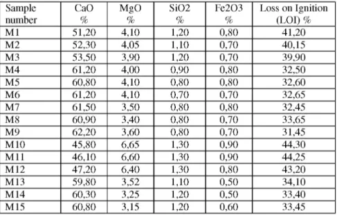
Chemical composition (weight %) of limestone from the Midyat formation is given in Table 1. Results from this table are in good agreement with field observations. In the limestone, CaO, MgO and LOI values are 46.10(62.20%), 3.15(6.40%) and 31.45(44.30%), respectively. These compositions indicate that chemical composition of the rock is very suitable for karst formation.
Likewise, karstification is quite well developed both at the surface and at depths.
Table 1. The chemical composition (weight %) of limestone of Midyat formation.
Sample CaO MgO SiO2 Fe2O3 Loss on Ignition
number % % % % (LOI) % M1 51,20 4,10 1,20 0,80 41,20 M2 52,30 4,05 1,10 0,70 40,15 M3 53,50 3,90 1,20 0,70 39,90 M4 61,20 4,00 0,90 0,80 32,50 M5 60,80 4,10 0,80 0,80 32,60 M6 61,20 4,10 0,70 0,70 32,65 M7 61,50 3,50 0,80 0,80 32,45 M8 60,90 3,40 0,80 0,70 33,65 M9 62,20 3,60 0,80 0,70 31,45 M10 45,80 6,65 1,30 0,90 44,30 M11 46,10 6,60 1,30 0,90 44,25 M12 47,20 6,40 1,30 0,80 43,20 M13 59,80 3,52 1,10 0,50 34,10 M14 60,30 3,25 1,20 0,50 33,40 M15 60,80 3,15 1,20 0,60 33,45
5. PROTECTION ZONES OF THE SPRINGS
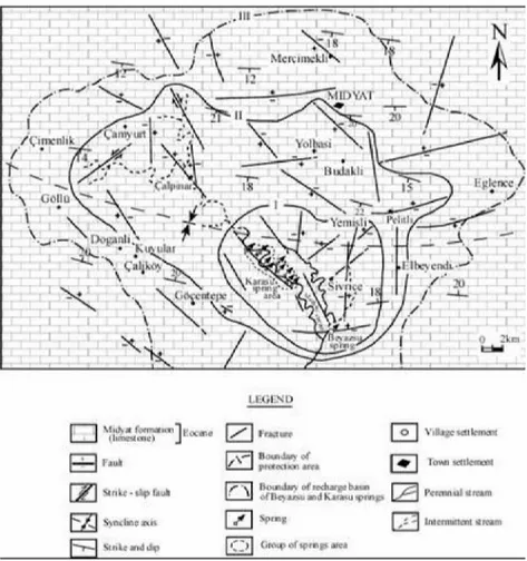
The Beyazsu spring issues from an E-W extending normal fault of 7.5 km in length. The Karasu spring is manifested from several points along a NW-SE trending normal fault of 10 km in length. Clay, marl and sandstones of the Gercüş formation at the base of the Midyat limestone comprise the impermeable part of the aquifer in the area. Since the Midyat limestone of aquifer rock character are quite fractured, faulted and karstic, their secondary porosity and permeability are high. Therefore, protection zones cover a large area.
Considering the faults, karstification and tectonic characteristics of the area, three different protection zones were determined for the springs (Fig. 10). 1st Zone: Works related to water production should be permitted. Any type of contamination must be prevented. Settlement areas and their waste pits and sewage system around the springs should be removed. Wastes of present facilities have to be must be taken out of the 3rd zone with the use of sewage canals. If possible, refinery facilities have to be established out of the 3rd zone and at least 5 km from the springs. A concrete pipe or impermeable canal should be built within the Mashari river bed where the Karasu spring is manifested. Areas around the spring sites must be grassed.
Bahattin ÇETINDAG - Ozlem OZTEKÎN OKAN
Figure 10. The map of protection area of Beyazsu and Karasu springs. 2nd Zone: Building of houses may be permitted if their wastes are taken out of the 3rd zone. However, the construction of structures such as stable, cemetery, chicken farm and chemical waste producing facilities should be never permitted.
3rd Zone: Basin borders recharging the springs comprise the 3rd Zone. Construction of facilities may be permitted as long as their wastes are removed out of the zone. However, the oil products resulting from oil exploration and exploitation activities must be never allowed to be stored in the area.
6. RESULTS
In this study, the discharge rate characteristics of the Beyazsu and Karasu springs in the real regime were studied for a two-year period. Discharge coefficients of the Beyazsu spring in 2003 in 2004 were found as a1B= 1.707*10-3 day-1 and a2B= 2.185*10-3 day-1. Storage capacity of this spring
at the beginning of discharge in the real regimes of 2003 and 2004 are calculated as 3.01x 10⁸ m3 and 2.27x 10⁸ m3. The amounts of water discharged by the Beyazsu spring on the discharge elevation during the 15 June-1 November 2003 and 1 June-1 November 2004 periods are found to be 6.33x 10⁷ m3 and 6.53x 10⁷ m3, respectively.
Discharge coefficients of the Karasu spring in 2003 in 2004 were found as a1K= 2.843*10-3 day-1 and a2K= 3.524*10-3 day-1. Storage capacity of this spring at the beginning of discharge in the real regimes of 2003 and 2004 are calculated as 9.88x 10⁷ m3 and 7.36x 10⁷ m3. The c o u n t s of water discharged by the Karasu spring during the 1 June-1 November 2003 and 15 June-15 November 2004 periods are found to be 3.49x 10⁷ m3 and 3.07x 10⁷ m3, respectively.
Karstification in the area has been developed association with lithology, tectonism and geographic factors. Various types of clints are observed on the surface of Midyat limestone while karstic void, space and caves are detected underground. Dissolution pans and chute like structures are the common clint types on the surface. Chemical composition of rock is another important factor for karst formation. Chemical analyses indicate that limestone have suitable composition for karstification.
As protection sites of the springs, three different zones were determined. In the first zone, works related to water production should be permitted. In the second zone, building of houses may be permitted if their wastes are taken out of the 3rd zone. The third zone was formed on the basis of basin borders recharging the springs.
Since waters of the Beyazsu and Karasu springs are also used as drinking waters in the area, bacterial and other contaminant analyses of these waters should be performed periodically.
Acknowledgement
The authers wish to give special thanks to the Geology Engineer Veysi Gümüş (10th Regional Directorate of General Directorate of State Hydraulic Works, Diyarbakır, Turkey) for his helps in field works and the other staff of 10th Regional Directorate of General Directorate of State Hydraulic Works.
Bahattin ÇETİNDAĞ - Özlem ÖZTEKİN OKAN
REFERENCES
[1] Tolun, N., Stratigraphy and tectonics of southeastern Anatolia. Istanbul University Fen Fak. Mecmu. Seri B, v. 15, No. 3- 4, (1960), 201-264 (in Turkish).
[2] Temple, PG., Rerry, LJ., Geology and oil occurence, southeast Turkey. Bull. Am. Ass. Petr. Geol., v. 46, No 9, (1962), 1596- 1612.
[3] Cordey, GW, Demirmen, F., The Mardin formation in south- east Turkey. 1st Petroleum Congress of Turkey, Abstract, (1971), 51-71 (in Turkish).
[4] Rigassi, D., Petroleum Geology of Turkey. In geology and History of Turkey, by A. J. Campbell; Tripoli- Libya, (1971), 453- 482.
[5] Özkaya, İ., Güneydoğu Anadolu Sason ve Baykan yöresinin stratigrafisi. Turkish Geol. Bull., 17-1, (1974), 51 (in Turkish).
[6] Ketin, İ., Van gölü ile İran sınırı arasındaki bölgede yapılan jeoloji gözlemlerinin sonuçları hakkında kısa bir açıklama. Turkish Geol. Bull., (1977), 20, 79-85 (in Turkish).
[7] DSİ, Güneydoğu Anadolu Projesi. DSİ Genel Müdürlüğü Etüd ve Plan Dairesi Başkanlığı, (1980), Ankara (in Turkish, unpublished).
[8] Perinçek, D. ; Özkaya, İ., Arabistan levhası kuzey kenarı tektonik evrimi. Hacettepe Yerbilimleri Dergisi, 8, (1981), 91-101 (in Turkish).
[9] Kaçaroğlu, F., Dumluca ve Subatan (Derik KB) alanının karst hidrojeolojisi incelemesi. M.Sc. Thesis. Hacettepe University, (1983), Ankara, 106 p (in Turkish, unpublished).
[10] Nazik, M. ; Önhon, E., Mardin- Nusaybin Beyazsu ve Karasu kaynaklarının geliştirme imkanlarının araştırılması karst hidrojeolojisi ön inceleme raporu, (1987), DSI, Ankara.
[11] Özel, E., Midyat(Mardin) ovası su kimyası incelemesi. Yüksek lisans tezi, Fırat Üniv. Fen Bil. Enst., (2003), 57 p (in Turkish, unpublished).
[12] Çetindağ, B., Investigation of discharge and groundwater contamination
characteristics around the Karasu spring, Muş area, Turkey. Enviromental Geology , 47, 2, (2005), 268-282.
[13] Drogue, C., Evolution de la capacite de retention par chenaux et fissures, chronique d'hydrogeologie, No: 10, (1967), 43- 47, Paris.
[14] Maillet, E., Essais d'hydrolique souterraine et fluviale. 1, 218, (1905), Paris. [15] Drogue, C., Essai d'identification d'un type de structure de magasins carbonates, fissures. Application a l interpretation de certain aspects du fonctionnement
hydrogeologique. Mem. H. Ser. Sec. Geol. France, no. 11, (1980), 101-108, Paris, France.