KARKAMI
Š
IN THE FIRST MILLENNIUM B.C.:
SCULPTURE AND PROPAGANDA
A Master’s Thesis
by
KADR
İYE GÜNAYDIN
Department of
Archaeology and History of Art
Bilkent University
Ankara
May 2004
KARKAMIŠ IN THE FIRST MILLENNIUM B.C.: SCULPTURE AND PROPAGANDA
The Institute of Economics and Social Sciences of
Bilkent University
by
KADRİYE GÜNAYDIN
In Partial Fulfilment of the Requirements for the Degree of MASTER OF ARTS
in
THE DEPARTMENT OF
ARCHAEOLOGY AND HISTORY OF ART BILKENT UNIVERSITY
ANKARA May 2004
I certify that I have read this thesis and have found that it is fully adequate, in scope and in quality, as a thesis for the degree of Master of Arts in the Department of Archaeology and History of Art.
--- Assoc. Prof. İlknur Özgen Supervisor
I certify that I have read this thesis and have found that it is fully adequate, in scope and in quality, as a thesis for the degree of Master of Arts in the Department of Archaeology and History of Art.
--- Asst. Prof. Charles Gates Examining Committee Member
I certify that I have read this thesis and have found that it is fully adequate, in scope and in quality, as a thesis for the degree of Master of Arts in the Department of Archaeology and History of Art.
--- Assoc. Prof. Aslı Özyar
Examining Committee Member
Approval of the Institute of Economics and Social Sciences
--- Prof. Kürşat Aydoğan Director
ABSTRACT
KARKAMIŠ IN THE FIRST MILLENNIUM B.C.: Günaydın, Kadriye
M.A., Department of Archaeology and History of Art Supervisor: Assoc. Prof. İlknur Özgen
May 2004
This thesis examines how the monumental art of Karkamiš, which consists of architectural reliefs and free-standing colossal statues, was used by its rulers for their propaganda advantages. The basic geo-politic and ethnic factors related to Karkamiš and other “Syro-Hittite” city-states of the Iron Age are investigated in order to obtain insights about the meanings assigned to the monumental sculpture of Karkamiš. Architectural remains of the city and their sculptural decoration are studied
and reviewed to provide a basis for subsequent discussions and statements. Monumental portal-lions, inscribed door-jambs and other reliefs placed on principal gate-ways, bearers of symbolic and functional meaning, demonstrate the essential role of these monumental gates for the city and its rulers to announce their ideologies. A close analysis of local monumental inscriptions provides us the link between the content of texts inscribed on large stone blocks and the themes represented on orthostat reliefs. Royal titles inscribed on monuments as well as a
group of reliefs and statues associated with ancestral cult were used deliberately by the dynasties and rulers of the 1st millennium B.C. Karkamiš to show their own and their state’s connection to the past heritage, a key element in the search of identity. This case study on the Iron Age city of Karkamiš reveals the importance of
socio-political factors in forming the basic characteristics of monumental art and in creating its special meanings and functions.
Keywords: Karkamiš, Syro-Hittite, Neo-Hittite, city states, architecture, art, sculpture, orthostat reliefs, propaganda.
ÖZET
M.Ö. BİRİNCİ BİNYILDA KARKAMIŠ: HEYKELVE PROPAGANDA
Günaydın, Kadriye
Master, Arkeoloji ve Sanat Tarihi Bölümü Tez Yöneticisi: Doç. Dr. İlknur Özgen
Mayıs 2004
Bu tez, Karkamiš’ın mimari taş kabartmacılığı ve anıtsal heykellerden oluşan sanatının şehrin yöneticileri tarafından propaganda amacıyla nasıl kullanıldığını irdelemektedir. Karkamiš ve diğer “Suriye-Hitit” şehir devletlerinin Demir Çağ’daki jeopolitik konumu ve etnik yapısı, Karkamiš’ın anıtsal sanatına yüklenen özel anlamı ortaya çıkartması açısından büyük önem taşır.
Şehrin gerek mimari kalıntılarının, gerekse kabartma ve heykel dekorasyonuna ait buluntularının gözden geçirilmesi ve tanımı düşünce ve yorumlarımız için temel oluşturmaktadır. Özel sembolik ve fonksiyonel anlamlar taşıyan anıtsal kapı aslanları, yazıtla kaplı kapı pervazları ve kapı girişlerine yerleştirilen diğer taş kabartmalar bize bu anıtsal kapıların kentin kendisi ve ideolojilerini yansıtması açısından onun yöneticileri için önemini göstermektedir. Karkamiš’ın anıtsal yazıtlarının incelenmesi bize metinlerin içeriği ve büyük taş bloklar üzerindeki kabartmaların temaları arasındaki uyumu ve bağlantıyı göstermektedir. Anıtlar üzerine kaydedilen kraliyet ünvanları ve atalara tapma
töreniyle ilişkilendirilen bir grup rölyef ve heykel, bir kimlik arayışı içinde olan devletlerini ve kendilerini tarihi bir miras ile ilişkilendirmek isteyen hanedan ve krallarca kullanmıştır.
Demir Çağ’daki Karkamiš şehri üzerine olan bu çalışmamız bize sosyo-politik faktörlerin anıtsal sanatın temel karakterlerini nasıl oluşturduğunu ve ona nasıl özel bir anlam ve işlev yüklediğini göstermektedir.
Anahtar Kelimeler: Kargamış, Suriye Hitit, Geç Hitit, şehir devletleri, mimari, sanat, heykel, taş rölyef , kabartma, propaganda.
ACKNOWLEDGMENTS
I would like to express my heartfelt gratitude to Assoc. Prof. İlknur Özgen, my advisor, for enabling me to choose this topic and for her advice, insight, encouragement and guidance all through the thesis. As a mentor she has also provided me with sincere inspiration and gracious compassion.
I am also grateful to the members of my jury, Asst. Prof. Charles Gates and Assoc. Prof. Aslı Özyar, for their valuable comments.
I am deeply indebted to late Norbert Karg for his unforgettable, valuable work with me, who first introduced and made me keen on Near Eastern and Anatolian art and archaeology.
Thanks are also due to all my teachers in the department, Assoc. Prof. Marie-Henriette Gates, Asst. Prof. Julian Bennett, Asst. Prof. Yaşar Ersoy, Dr. Jacques Morin, and Benni Claasz Coockson. I also would like to thank Dr. Thomas Zimmermann, who kindly helped me in translating some German texts.
I am deeply grateful to my mother, father and brother, who let me be free in what I wanted to study, and intimately supported me in all of my choices. I owe a lot to their support, love, trust and patience.
Finally my friends, to whom I owe much: Nehriban, Gülsüm, Hakkı, and Nurşen who were my morale boosters. I also would like to thank to my roommate Nur, for her help and support whenever needed. Thanks are also due to Sengör, Barla and Engin for their technical support.
TABLE OF CONTENTS
ABSTRACT ... iii
ÖZET ... v
ACKNOWLEDGMENTS ... vii
TABLE OF CONTENTS ... viii
LIST OF TABLES... x
LIST OF FIGURES ... xi
CHAPTER I: INTRODUCTION ... 1
CHAPTER II: HISTORY OF SCHOLARSHIP ... 9
CHAPTER III: HISTORY AND GEOGRAPHY OF THE AREA ... 16
3.1 Syro-Hittite States ... 16
3.1.1 Karkamiš... 26
CHAPTER IV: THE TOWN OF KARKAMIŠ AND ITS REMAINS ….……... 32
4.1 Plan ... 33
4.2 Principal Buildings ... 34
4.3 Principal Architectural Units and Their Sculptural Programs ... 37
4.3.1 The Water Gate ... 39
4.3.2 The Hilani ... 42
4.3.3 The Long Wall of Sculpture ... 43
4.3.4 The Great Staircase ... 45
4.3.5 The Herald’s Wall ... 50
4.3.6 The King’sGate ... 54
CHAPTER V: THEMES IN THE LIGHT OF INSCRIPTIONAL AND SCULPTURAL EVIDENCE ... 63 5.1 Royal Images ... 63 5.2 Military Representations ... 72 5.2.1. Epigraphic Evidence ... 75 5.2.2 Sculptural Evidence ... 75 5.3 Religious Representations ... 83 5.3.1 Epigraphic Evidence ... 83
5.3.3 Statues and Stelae ... 93
5.4 Hunting Scenes ... 100
5.5 “Mytho-Heroic” Representations ... 104
5.6 Protective Curses ...…... 108
CHAPTER VI: IMPORTANCE OF GATES FOR THE CITY OF KARKAMIŠ ... 112
6.1 Gate-Structures ... 112
6.1.1 Portal-Lions and Sphinxes ... 113
6.1.2 Inscribed Door-Jambs ... 117
6.1.3 Reliefs on Gate Chambers ... 118
CHAPTER VII: THE SEARCH FOR IDENTITY ... 125
7.1 Royal Titles ... 126
7.2 “Funerary Monuments” ... 135
CHAPTER VIII: CONCLUSION... 144
8.1 Propaganda and Karkamiš’s Monumental Art ... 145
8.2 Propaganda in Karkamiš in the light of History ... 157
SELECTED BIBLIOGRAPHY... 165
TABLES ... 180
LIST OF TABLES
Table 1. The dynasty of Great Kings (of x-pa-zatis) and
Country Lords (of Suhis) ... 181
Table 2. King List of Karkamiš in the 1st millennium B.C. (after, Hawkins 1974: 69-70; Hawkins 1976-80: 441-42; Hawkins 2000: 72) ... 182
LIST OF FIGURES
Fig. 1. Map of Southeast Anatolia and North Syria in the Iron Age.
(Hawkins 1982:Map 14) ... 184
Fig. 2. Plan of Karkamiš. (Woolley 1921: Pl. 3)... 185
Fig. 3. Plan of the Water Gate. (Woolley 1921: Pl. 16)... 186
Fig. 4. Topographic plan of Karkamiš (Hogarth 1914). ... 187
Fig. 5. Sketch Plan of Excavated Area in Karkamiš, from Water Gate to King’s Gate and Great Staircase. (Woolley – Barnett 1952: Pl. 41) ... 188
Fig. 6. Plan of the “Lower Palace Area” including the Long Wall of Sculpture, the Great Staircase, and the Temple of the Storm God. (Woolley – Barnett 1952: Pl. 29) ....…... 189
Fig. 7. The Reconstruction of the Great Staircase Area. (Woolley – Barnett 1952: Pl. 30 ... 190
Fig. 8. Plan and orthostats of the King’s Gate including Royal Buttress, Processional Entry, Gate-Chamber and Herald’s Wall; (Woolley – Barnett 1952: Pl. 43a) ... 191
Fig. 9. Orthostat reliefs from the Water Gate. (Woolley 1921: Pl. B 28- B 29). ... 192
Fig. 10. Libation scene from the Water Gate. (Woolley 1921: Pl. B 30a) ... 193
Fig. 11. Banquet scene from the Water Gate. (Woolley 1921: Pl. B 30b). ... 193
Fig. 12. Orthostat reliefs from the Water Gate. (Woolley 1921: Pl. B 31). ... 194
Fig. 13. Plan of Hilani. (Woolley – Barnett 1952: Pl. 38) ... 195
Fig. 14. Fragmentary reliefs from the divine procession of the Long Wall of Sculpture. (Woolley – Barnett 1952: Pl. B 38- B 40) ... 196
Fig.15. Chariot reliefs from the Long Wall of Sculpture. (Woolley – Barnett 1952: Pl.B 41- B 43a) ... 197
Fig. 16. Reliefs depicting foot-soldiers from the Long Wall of Sculpture. (Woolley – Barnett 1952: Pl. B 44- B 46) ... 198
Fig. 17. Reconstruction of the military representations on the Long
Wall of Sculpture.(Hawkins 1972: Fig. 4a) ... 199
Fig. 18. Reconstruction of the divine representation on the Long Wall of Sculpture. (Hawkins 1972: Fig. 4a). ... 200
Fig. 19. Fragmentary orthostats from the Great Staircase. (Woolley – Barnett 1952: Pl. B 35a, b, c, d; B 36a, c; B 26f) ... 201
Fig. 20. Fragments of the inscribed lion A 14a (of Suhis) and its reconstruction. (Woolley 1921: Pl. B 31c; Ussishkin 1967a: Figs. 3-5) ... 202
Fig. 21. Fragments of the inscribed lion A 14b (of Astuwatamanzas) and its reconstruction. (Hawkins 2000: 84)... 203
Fig. 22. Reconstruction of the right side of the Outer Gate of the Great Staircase gate tower. (Hawkins 1972: Fig. 4b). ... 204
Fig. 23. Reconstruction of the left side of the Outer Gate of the Great Staircase gate tower. (Hawkins 1972: Fig. 4b). ... 205
Fig. 24. Fragments of a lion, assumed by Ussishkin to be the counterpart of Lion A 14a (of Suhis). (Ussishkin 1967a: Figs. 6-7) ... 206
Fig. 25. Portal lion from the South Gate. (Woolley 1921: Pl. B 27b). ... 206
Fig. 26. Orthostats from the Herald’s Wall. (Hogarth 1914: Pls. B10-B12). ... 207
Fig. 27. Orthostats from the Herald’s Wall. (Hogarth 1914: Pls. B13-B15a). ... 208
Fig. 28. Orthostats from the Herald’s Wall. (Hogarth 1914: Pls. B15b-B16). ... 209
Fig. 29. Foot-soldiers from the eastern wall of the King’s Gate. (Hogarth 1914: Pls. B 2- B 3) ... 210
Fig. 30. Army-officers from the north wall of the Royal Buttress. (Hogarth 1914: Pls. B 4-B 5). ... 211
Fig. 31. North façade of the Royal Buttress depicting the ruler Yariris and prince Kamanis and the royal family. (Hogarth 1914: Pls. B 6-B 8). ... 212
Fig. 32. Orthostats from the Staircase Recess. (Woolley 1921: Pl. B 17b-18)... 213
Fig. 33. The Goddess Kubaba, and female offering-bearers from the Processional Entry. (Woolley 1921: Pl. B19- 22a). ... 214
(Woolley 1921: Pl. B 22b-24a). ... 215 Fig. 35. Reliefs from the Inner Court, King’s Gate. (Woolley – Barnett 1952:
Pl. B 55b- B 59). ... 216 Fig. 36. The statue of the god Atrisuhas (deified king Suhis) and its base.
(Woolley 1921: Pl. B 25 = B 54, B 26a). ... 217 Fig. 37. Orthostat block from western short outer wall of the gate-chamber of the
King’s Gate. (Woolley 1921: Pl. B 26b, c). ... 218 Fig. 38. Fragmentary relief showing heads of four charioteers.
(Woolley – Barnett 1952: Pl. B 61a). ... 218 Fig. 39. Heads of statues of rulers or deities. (Woolley – Barnett 1952:
Pl. B 54a, B 67a, c, d, e; B 69b). ... 219 Fig. 40. Reliefs with charioted hunting scenes, from King’s Gate Area.
(Woolley – Barnett 1952: Pl. B 60). ... 220 Fig. 41. Headless statues of seated figures (deified royal members?). (Woolley –
Barnett 1952: Pl. B 48b, B 68c). ... 221 Fig. 42. Fragment of a standing colossus, B 27a. (Woolley 1921: Pl. B 27a). ... 221 Fig. 43. Double lion- or bull- bases for statues. (Woolley – Barnett 1952: Pl. B 47, B 53a+b, B 32) ... 222 Fig.44. Reliefs depicting prisoners, refugees and/or tribute-bearers.
(Gerlach 2000: Fig. 8a; Woolley – Barnett 1952: Pl. B 68b) ... 223 Fig. 45. Picture and the drawing of the relief depicting the Sun God and
the Moon God. (Woolley – Barnett 1952: Pl. B 33) ... 224 Fig. 46. Fragments of stelae and statues depicting gods and goddesses. (Woolley –
Barnett 1952: Pl. B 62a, B 63a, B 63b, B 64a, B 64b+c). ... 225 Fig. 47. Fragments of reliefs showing bull-men flanking the Sacred Tree.
(Woolley – Barnett 1952: Pl. B 49a; B 52b, c, d, d, e, f) ... 226 Fig. 48. Relief showing a gazelle, from the Great Staircase Area.
(Woolley – Barnett 1952: Pl. B 61b). ... 227 Fig. 49. Fragments of portal-lions. (Woolley – Barnett 1952: Pl. B 62b,
B 69b, B 70a, b; B 70d). ... 228 Fig. 50. Complete and fragmentary reliefs depicting lion and/ or sphinx.
(Woolley – Barnett 1952: Pl. B 48a, B 70c, B 55a, B 68e, B 69a) ... 229 Fig. 51. Drawing of the inscription A 1a. (Hawkins 2000: Pls. 6-7). ... 230 Fig. 52. Photograph and drawing of the inscription A 1b.
(Hawkins 2000: Pl. 8)... 231 Fig. 53. Photograph and drawing of the inscription A 13d.
(Hawkins 2000: Pls. 24-25)... 231 Fig. 54. Photograph and drawing of the inscription A 11a.
(Hawkins 2000: Pls. 10-12)... 232 Fig. 55. Photographs and drawing of the inscription A 11b.
(Hawkins 2000: Pls.14-15)... 233 Fig. 56. Photograph and drawing of the inscription A 11c.
(Hawkins 2000: Pls. 16-17). ... 234 Fig. 57. Photograph and drawing of the inscription A 2.
(Hawkins 2000: Pls. 18-19)... 235 Fig. 58. Photograph and drawing of the inscription A 3.
(Hawkins 2000: Pls. 20-21). ... 236 Fig. 59. Photograph and drawing of the inscription A 12.
(Hawkins 2000: Pls. 22-23). ... 237 Fig. 60. Photograph and drawing of the inscription A 23.
CHAPTER I
INTRODUCTION
“All art is to some extent propaganda.”
George Orwell1
Throughout ancient history visual art was the most important means of propaganda. In ancient societies, and particularly in well-known empires, kingdoms and city-states, figurative art was favored in order to promote political, religious and social ideologies of the rulers. At that time, visual propaganda is most commonly revealed in paintings and sculptural reliefs adorning the interiors and exteriors of both secular and sacred monuments.
A number of studies (Reade 1972; Reade 1979; Liverani 1979; Winter 1981; Winter 1983b; Winter 1997; Parpola 1995; Porter 2000; Gerlach 2000) focusing particularly on the propagandist purpose and function of Neo-Assyrian art and architecture have led me to question whether the monumental art of the “Syro-Hittite” city of Karkamiš2 could have carried such an intention. Other publications, (Larsen
1
Quoted in, Evans 1992: 7.
2
In previous publications which refer to Karkamiš, we find that the name of the city is transcribed in a number of different ways: Carchemish, Karkamiš, Kargamiš, Karkamish, Karkamiş and Karkamish. In my study I prefer to use the form Karkamiš as Hawkins (2000) does.
1979; Evans 1992; Nylander 1979; Asena 2002) which deal with visual art of various ancient cultures and claim that art has been an important media for transmitting certain messages, ideologies and beliefs, have further encouraged me to believe that the sculptural art of Karkamiš must have had such a role as well. Also studies on modern understanding of communication, propaganda and persuasion (Ellul 1973; Hawthorn 1987; Taylor 1996; Clark 1997; Sproule 1997; Severin and Tankard 1997; Jowett and O’Donnell 1999) allowed me to create my own ideas concerning how the art of Karkamiš will serve the propagandist goals of the state and its rulers.
In this thesis, out of a number of “Syro-Hittite” states I focus on Karkamiš. It was the central and the most vital of these states. Also, comparing to the other sites we have much more local textual and sculptural evidence as well as more complete scholarship (mostly written in English) about Karkamiš. Regarding other Syro-Hittite centers, most of the studies are excavation reports of the sites, which present the material without any deep analyses. Thus, Karkamiš is considered as a good representative of these Syro-Hittite states. For, the nature of literature and the function of sculptures and inscriptions seem not to differ much although the language and script of inscriptions show variations (depending on the ethnic dominators of the states).
Thus, this study will examine how art, particularly the representational art of Karkamiš, together with local inscribed texts, provide us evidence for the propagandist aims of the rulers of the state. Since the study attempts to detect some socio-political aspects from art and written sources, both the available information for the history of Karkamiš and its archaeological remains of sculpture will be examined.
Before introducing the content of chapters it seems important and necessary to define the term “propaganda” as used in this thesis, and to question why monumental art was significant as propaganda in ancient societies.
As Porter (2000: 145) states “the word propaganda has acquired a wide range of meaning in modern usage”. In the Near Eastern discussion, “it has been used in the more restricted and projective sense of the word” describing a deliberate, systematic attempt to shape perceptions, manipulate cognition, direct behavior and modify the attitudes of an audience (Porter 2000: 145; Jowett -O’Donnell 1999: 6). On the other hand, modern understanding of propaganda allows us to see more clearly and to understand better the propagandist functions of the sculptural works. One imagines that the ancient people received propaganda in many ways, just as modern people do.
Clearly, the ancient rulers were also aware of the great effectiveness of representational art for the purpose of making the populace accept their interests and beliefs. Therefore, they chose to adorn the strategic places of their cities, city-gates, palaces and tombs with figurative scenes that carried their propagandist and protective messages. Similarly, the rulers of the 1st millennium city-state of Karkamiš used art on monumental scale to reiterate their power, glorify their victories or to intimidate and defame their enemies.
The monumental sculptural decoration was favored enormously in Karkamiš as it was in the other major cities of the Syro-Hittite states in the Iron Age. Obviously it was not merely employed for their decorative function. Instead orthostats that bear reliefs with various intentionally chosen themes and free-standing statues of deities and
rulers seem to be an important media for communication and for making propaganda for their rulers and for their states.
In a political unity rulers must communicate in some way with the populace under their rule. Those at the top of the administrative unit use several channels for communication to promote their own messages and objectives. The message, that is the representation of propaganda, can take a number of forms, such as significant symbols, pictures or other spoken, written or pictorial forms of social communication.
Through the ages, art has become one of the major channels used by political entities for communication and propaganda. When the art is “state art” and when the patron is the ruler of that state, then art and particularly monumental art inevitably included to some extent the element of propaganda and persuasion.
In state art, the propagandist is usually the ruler. So, it is quite understandable that the sculptural representations were the field for the king of the state to send his message to the public. Through the subject matter of figurative representations that were occasionally accompanied by inscriptions, the patrons intended to manipulate people’s beliefs, attitudes, or actions. Specific symbols and/or pictures were employed to control the public opinion in general. The purpose of the propagandist, in this case of the ruler, is to promote his or her own objectives and interests.
In antiquity, especially in the 2nd millennium B.C. and in the 1st millennium B.C. architectural and sculptural works were symbols intentionally created to evoke a specific image of superiority and power that the early propagandists wished to convey to their audience.
“Propaganda, to be effective, must be seen, remembered, understood, and acted upon” (Qalter 1962: xii, quoted in Jowett-O’Donnell 1999: 5). So the acts of seeing and understanding are among the basic factors of propaganda. Therefore, through figurative representations, which are open to visual perception and often are easily understandable by a large audience, the propagandists were able to achieve their goals more directly and effectively.
Visual propaganda was also one way to overcome illiteracy to reach a maximum audience. Obviously in antiquity, literacy was very limited. On the other hand, the target group of propaganda was usually the general public, who were mostly illiterate. So, conveying messages through visual representations was the most natural way in those days.
The durability of the media has a special importance as well, because the media also served for the transmission of the social heritage from one generation to the next. Definitely in the ancient times, stone was the most favored medium for the symbolic art. The artworks together with the given messages were passed to the next generations. This allowed the message a long-term effect and durability. So, the use of stone sculpture as a media for making propaganda is quite understandable.
Depending on these evaluations, I mean to suggest that the visual and verbal imagery of the reliefs of Karkamiš was designed less to inform than to persuade, and that the reliefs appear to have been designed at least in part to influence the political attitudes and behavior of different audiences. The discussion of propaganda in Karkamiš focuses primarily on the images and texts that were presented to audience in the gates, palaces(?) as part of other monumental buildings.
How I will achieve and emphasize the propagandist features on the sculptural works of Karkamiš will be given in the following. The second chapter gives a brief account of the history of archaeological research carried out at the site of Karkamiš, as well as the history of what has been studied so far about its remains, especially those of sculpture. It shows us how looking at art with a new, socio-political perspective is also necessary.
Based on documentary sources and archaeological studies, the third chapter gives the history and geography of the 1st millennium B.C. “Syro-Hittite” states, concentrating on that of Karkamiš.
The fourth chapter covers the city of Karkamiš, its possible major administrative and religious buildings and its architectural remains. It reviews the archaeological records related with the sculptural work of the site. Physical aspects of specific architectural features where the orthostats and statues were placed, as well as subject matter and dating of the sculptures will be examined. The chapter deals with each excavated architectural unit separately. The main sources that I will rely on in this chapter are the actual excavation reports (Hogarth 1914; Woolley 1921; Woolley, 1952), their basic review (Güterbock 1954), and a later work by Özyar (1991), which reevaluates the architectural relief sculpture of Karkamiš in accordance with new observations. The content of this chapter will serve as background information and provide us with basic supportive elements for my arguments.
Problems and related suggestions concerning the sculptural programs and dating of sculptures will also be considered. For which sculptural program belongs to which particular ruler is a crucial point for our discussions and statements. Summarizing the
basic characteristics of these architectural features and their sculptural program will contribute to the understanding of the architectural layout and decoration of the basic monuments at the citadel of Karkamiš.
The excavated area of the inner town, shown in Fig. 5 (Woolley - Barnett 1952: Pl. 41), will constitute the main basis of this chapter. The excavation of the site could not be completed; a big portion of the area including the citadel remains unknown. This will restrict our perspective and arguments. Nevertheless, an attempt to write in accordance with the available archaeological investigations and finds will give an idea about some issues concerning the socio-political circumstances of the state.
Most of the names of the uncovered building structures were nicknames given by the excavators themselves. Afterwards these names have continued to be used by the following scholars, and I shall do so in my study as well.
The following chapter five attempts to understand how the texts of the inscriptions correspond with representations of particular themes on orthostats, and the importance of royal and divine figures carved in the round. In most cases each theme will be firstly examined in the available textual sources and then in the sculptural depictions. My textual evidence will be the translations published by Hawkins (2000), where he also takes into account and reevaluates previous transliterations and translations of other scholars (Meriggi 1934a, 1934b, 1954, 1975; Laroche 1960a).
The sixth chapter focuses on the gate-structures of Karkamiš. It attempts to examine how portal lions, inscribed door-jambs and other reliefs on the gateways carried a particular symbolic and functional meaning.
The seventh chapter discusses how some particular items, such as the royal titles appearing on local written documents and the funerary monuments were used by the rulers to proclaim a socio-political identity for their states.
The final chapter summarizes my arguments concerning how free-standing sculpture as well as architectural reliefs with their intentionally chosen subject matters, mostly accompanied by textual evidence, contribute to the rulers of Karkamiš in their aims of transmitting their messages, ideologies and propaganda to the target audience. The historical and socio-political circumstances of Karkamiš, including the plan of the city within the “Syro-Hittite” culture in the Iron Age, will be correlated with the architectural and monumental sculptural remains of the site.
It is beyond the aim of this thesis to single out in detail the different iconographical and iconological aspects of sculpture of Karkamiš, its origin in the local Syrian and Anatolian past, or its possible stimulation from other contemporary cultures’ art. Since this study is a case study on one site, using the available local textual and sculptural evidence as the main supportive media, comparative material from other neighbor states and cultures will be included sparingly. For the modest aim of the study is to understand how the rulers of Karkamiš used sculpture as an efficient media for proclaiming their power, ideology and objectives.
CHAPTER II
HISTORY OF SCHOLARSHIP
Archaeological excavations at Karkamiš (modern Jerablus)3 were conducted on behalf of the British Museum in the late 19th and early 20th centuries. Because of political circumstances, the excavations were done in three consecutive periods. The site was first excavated by P. Henderson from 1878 to 1881 (Hogarth 1914: 910). The second excavation program was directed by D. G. Hogarth and later T. E. Lawrence in 1911-1914 (Hogarth 1914: 12). Lastly the third one, carried out in 1920, was headed by C.L. Woolley (Hawkins 1976-80: 434-435). However, the excavations were not continued since Karkamiš is located on the frontier line between modern Turkey and Syria.
The principal publication of the site is entitled Carchemish, which consists of three volumes. Earlier excavations are described in Carchemish, Part I (“Introductory”), published by Hogarth in 1914, and then in Carchemish, Part II (“The Town Defences”), published by Woolley in 1921. The last, Part III, published in 1952, presents orthostat reliefs in the section “The Excavations in the Inner Town” by C. L. Woolley, and inscriptions in the section “The Hittite Inscriptions” by R. D. Barnett. In the original
3
While the inner town and the citadel are situated in Turkey, most of the outer town is in modern village of Jerablus, now in Syria (Hawkins 1976-80: 434-435).
publications the excavated inscriptions were defined as A- series and reliefs as B- series. In my study I will also follow these original series numbers, as is the case in many other studies.
Since adequate evidence for dating of the orthostats is limited, the matter of chronology is one of the main issues which has been discussed about the Karkamiš finds. In Carchemish, Part III, Woolley (1952) not only presented the full range of material but also assigned the excavated buildings and monuments to various reigns and dates. For the epigraphic evidence of the Hieroglyphic Hittite/Luwian inscriptions, he relied on the study by R.D. Barnett (1952). Here Barnett constructed a chronological framework for Karkamiš based on the names and genealogies appearing in the inscriptions. However, several of his readings required subsequent correction. Detailed epigraphic criticism was presented particularly by Güterbock (1954: 102-14) and Meriggi (1954: 1-16) in their reviews of Barnett’s volume.
Studies following Carchemish III, i.e. by Bossert (1951), Güterbock (1954),
Meriggi (1952; 1953; 1954: 1-16) and Laroche (1955: 17-22) have in general confirmed Woolley’s and Barnett’s datings (Woolley - Barnett 1952: 263-66), even though they corrected and modified them in detail (Hawkins 1976-80: 439). On the other hand, Akurgal (1962; 1966: 104-110) and Ussishkin (1967a: 91-92)4 offered different chronological conclusions. Orthmann (1971), Mallowan (1972: 63-85), Hawkins (1972; 1972-75: 152-159; 1974) and Genge (1979) are among other scholars who further
4
contribute to the argument5. Although a few controversial issues remain, they have agreed more or less with Woolley’s view of chronology (Hawkins 1976-80: 439).
It also has been suggested that the stylistic differentiation will solve the problem related with the dating of the orthostat reliefs. The pioneers of such studies are Akurgal (1961; 1962; 1976) and Orthmann (1971: 29-44). They divided “Syro-Hittite” art into a number of stylistic groups which equate to a particular period of time. Genge (1979: 59-90) also examines the sculpture in stylistic terms in order to reach a more accurate chronology (Özyar 1991: 7). Orthmann’s and Genge’s studies and chronologies seem to be close, but independent from each other (Hawkins 1976-80: 439-441). Out of them Orthmann’s chronological division is the most accepted and commonly referred one. Several scholars such as Hawkins (1972; 1974; 1976-80), Özyar (1991) and Darga (1992) use, comment or refer to Orthmann’s chronology in their works.
Özyar (1991) in her Ph.D. thesis focused particularly on technical aspects, architectural context and the iconography of architectural relief sculptures at Karkamiš and Malatya, sites with Hittite/Luwian character, and Tell-Halaf, a site with Hurrian and later Aramaean character. She reevaluated the internal chronology of the reliefs, to follow the sculptural program, and to examine the possibility of changes in programs in different periods and in general to understand the cultural aspects of the iconography on the reliefs.
Also, some studies questioned the origin of the orthostat relief tradition in the “Syro-Hittite” states (Frankfort 1955: 166; Akurgal 1966: 62; Mallowan 1972: 64-66; Hawkins 1972: 106; Winter 1975a: 177; Bittel 1976: 238, 279; Winter 1982: 346;
Özyar 1991: 5-7; Özyar 1998: 633). They asked whether the practice of using monumental reliefs was a continuation from the 2nd millennium B.C., or was an innovation, or was inspired by the Neo-Assyrian art. Frankfort (1955: 166) and Mallowan (1972: 64-66) believed that the common practice of orthostat carvings in Syro-Hittite states is a Neo-Assyrian influence rather than a continuation from the Hittite Empire, and that the earlier Karkamiš orthostats were inspired by Assurnasirpal II’s palace at Nimrud (Özyar 1991: 5-6). The direction of influence of some themes (for instance, chariot reorientations) at least was most probably from Assyria to the west (Winter 1975a: 177).
On the other hand, some scholars have suggested that the art of the 1st millennium states of North Syria was a continuation of Hittite culture, rather than an Assyrian inspiration (Özyar 1991: 6-8; Akurgal 1966: 626; Bittel 1976: 238, 2797; Hawkins 1972: 1068; Winter 1982: 3649). A very recent study (Melchert 2003a), which is based on a remarkable research about the Hittite/Luwian epigraphic and cultural remains, also supports the idea of continuity from the Hittite/Luwian culture, instead of innovation or adaptation from the Assyrian traditions. In this last publication a number of specialists (Melchert 2003b; Melchert 2003c; Melchert 2003d; Bryce 2003; Hawkins
6 Akurgal (1966: 62) believed in Hittite continuity and that is why he chose to use the term “Late
Hittite” for the 1st millennium North Syrian states (Özyar 1991: 6, n. 1).
7
Judging from the use of Hieroglyphic Luwian inscriptions, Bittel (1976: 238, 279) also suggested the continuity of Hittite culture, however, with themes in a distinct stylistic manner, not related to earlier works of art (Özyar 1991: 6, nn. 2-3).
8
Hawkins (1972: 106) implied that Late Hittite art was independent of Assyrian art (Özyar 1991: 7, n. 3).
9
Winter (1982: 364) also disagreed with Mallowan’s argument that the Neo-Assyrian art was the model for that of Karkamiš (Özyar 1991: 8, n. 2).
2003; Hutter 2003; Aro 2003) have seen various Luwian aspects within the Hittite culture by re-evaluating the “Hittite” cultural elements.
The inscriptions found in Karkamiš are another set of material that has interested a number of scholars. Publications about the decipherment of the Hittite/Luwian hieroglyphic script in general began in the 1930s. The earliest studies are by Meriggi (1933, 1934a, 1934b), Gelb (1931, 1935, 1942), Forrer (1932), Bossert (1932) and Hrozny 1933, 1934, 1937). The following publications in the 1960s by Laroche (1960a) and Meriggi (1962) have remained basic to the study of the Luwian hieroglyphs up to the present.
Contributions to the field of local inscriptions at Karkamiš are mainly published by Meriggi (1967; 1975) and Hawkins (1972; 1975; 2000). Meriggi’s work presented all Hittite/Luwian hieroglyphic texts in copy, transliteration and translation with commentary. For over 25 years it was considered as a main reference work. Hawkins (1972) also presents transliterations, translations and discussions of inscriptions relating to the Long Wall of Sculpture and the Great Staircase in order to illuminate the history of construction of these monuments.
Furthermore, Hawkins’ recent publication (2000) about the Hittite/Luwian inscriptions is an essential source. Here he presents Luwian Hieroglyphic inscriptions found throughout Central and Southeastern Anatolia and North Syria in the Iron Age, with descriptions, transliterations, translations and commentary as well as their photographs and drawings. This study will be my major source for socio-historical information about the state of Karkamiš.
The history and geography of the “Syro-Hittite” states, including Karkamiš have been presented by D. Hawkins (1982; 1995a, 1995b). Hawkins has also published a substantial summary of all aspects of Karkamiš including the topography, textual references, the history of excavation and scholarship, as well as other historical information about the site (Hawkins 1976-80; Hawkins 2000: 73-79). Another essential study concerning the geographical, historical and possible economic situations in North Syrian states in the 1st millennium B.C. is the Ph.D. dissertation of Winter (1975a). The potential economic power and role of the state of Karkamiš, is separately discussed later (Winter 1983). In both studies she suggests that Karkamiš was a significant economic center of art production and of craftsmen, thus being a cultural centre of the North Syrian and Southeast Anatolian states during the 10th - 9th century BC.
Recently a few studies have concentrated on the functional and symbolic meaning of the free-standing sculptural figures found frequently in the “Syro-Hittite” sites (Ussishkin 1970 and 1975; Hawkins 1980 and 1989; Bonatz 2000a and 2000b). It is a common assumption in these works that the colossal statues of the “Syro-Hittites” are related with the funerary cult and the worshipping of the dead.
Consequently the so-called “Syro-Hittites”, who geographically and in some extent historically take a position between the Hittite lands and the Neo-Assyrian Empires, have constantly attracted the interest of scholars for a long time. Most of the studies concerning Karkamiš and its art have been published in the 1970s and early 1980s. As we mentioned above, the majority of them have dealt with the stylistic and chronological problems. Recently, studies about the deciphering and interpretation of the Hieroglyphic Luwian from Karkamiš led to the appearance of new questions.
New finds as well as new connections will add important links to our understanding of the historical framework of Karkamiš.
Inspired by the studies written on the propagandist purpose of the monumental art of the Assyrians, I believe that propaganda was one of the functions of Karkamiš sculpture. Therefore, I will try to reevaluate the existing epigraphic and material remains in terms of this new perspective.
CHAPTER III
HISTORY AND GEOGRAPHY OF THE AREA
I believe that a look at the socio-political conditions of Southeast Anatolia and North Syria during the 1st millennium B.C. can contribute to the understanding of the propagandist function of the sculpture in the site of Karkamiš. For the state’s and its rulers’ ideology was closely connected to the internal and external political affairs, to the nature of ethnic groups and dynasties active within the state and in the neighborhood as well as the religious beliefs predominant in the area. Thus knowledge of basic political, ethnic and religious conditions within Karkamiš, other Syro-Hittite states and other dominant powers in the region will allow us to understand better the need for propaganda made via sculpture of the city.
3.1 The Syro-Hittite States
The 1st millennium and its culture in Southeast Anatolia and North Syria have been named variously by scholars. It seems difficult and debatable to give a certain and a united name for this culture and period. “Late-Hittite”, “Neo-Hittite” and “Syro-Hittite” are the most favored ones. The term “Syro-“Syro-Hittite” seems to me more
states, the “Hittite” designates the cultural content. In fact, these states occupied the region including North Syria and South Anatolia stretching to Konya. At least in the earlier periods of the states in South Anatolia and North Syria the Hittite/Luwian components dominated. Hawkins (1974: 68) also favors this term to emphasize the mixed nature of the Anatolian-Aramaean population and culture of Syria. It is clear that some socio-cultural traditions were borrowed and continued from the Hittite Empire period. A number of ethnic groups with different languages and scripts have lived in the region.
After the collapse of the Hittite Empire towards the end of the 13th century B.C., Syria also participated in a common situation of destruction, instability and lack of power. The beginning of the Iron Age in Syria is characterized by the absence of both local and regional centers of political control. The political geography that was previously controlled by the Hittite Empire changed considerably. The disappearance of effective political control on almost all the territory of Syria resulted in the rise of new “autonomous political entities” in the area (Sader 2000: 62).
With the exception of Karkamiš, all local 2nd millennium kingdoms of the region disappeared in the 12th century B.C. “leaving no trace of their capitals and cities in the surviving documents of the Iron Age” (Sader 2000: 61). Two centuries later, new states had replaced them but with different names, and occupied different territories (Hawkins 1982: 374; Hawkins 1995b: 1296).
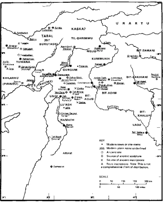
During the Iron Age we see a completely different political and geographical picture in the region. Now the geography was divided into a number of small kingdoms and city-states which had no general overlord (Fig. 1). The principal states were
Karkamiš, Melid, Gurgum, Kummuh, Unki, Que, Sam’al, Hamath, Agusi, Bit-Adini, Arpad and Damascus. These Syro-Hittite states existed and flourished in the area from the Late Bronze Age until the final annexation of these kingdoms to Assyria in the 8th century B.C. (Hawkins 1982: 380-420).
The geographical location of these “kingdom-like states” is worth noting. The city-state of Karkamiš possessed a kind of central place among these kingdoms and was located on a crossing of Euphrates (Winter 1975a: 41-42). To the west of Karkamiš at the eastern flank of the Amanus was located the small, principally Aramaean state of Sam’al (modern Zincirli) (Winter 1975a: 47-48, 108-112). To the north of Sam’al was the Hittite/Luwian kingdom of Gurgum with its capital at Marqas (Marqasi, modern Maraş) (Winter 1975a: 50, 112-113; Hawkins 2000: 249). Gurgum’s eastern and Karkamiš’s northern neighbor was another Hittite/Luwian kingdom, Kummuh (classical Commagene), with a capital of the same name at the site of Samsat Höyük (Samosata) (Winter 1975a: 52-53, 114; Hawkins 2000: 330). Across the Taurus on the Upper Euphrates, a large kingdom appeared at Melid (classical Melitene, modern Malatya), ruled from the capital of the same name. It controlled the northern-eastern passes through the Taurus (Winter 1975a: 60-63, 114-115; Hawkins 2000: 282-283).
Westwards through the Taurus, the southeastern corner of the Anatolian plateau was generally known as Tabal in this period, and seems to have been divided into a number of states (Winter 1975a: 115- 116; Hawkins 1982: 376: n. 18). In Cilicia there were two states, the Kingdom of Que (classical Campestris) and the land of Khilakku (classical Aspera) (Winter 1975a: 116-117; Hawkins 1982: 376, n. 19; Hawkins 2000: 38).
To the south of Karkamiš lay the tribal state of Bit-Adini, with its capital Til-Barsib (Winter 1975a: 55, 88-89; Hawkins 1982: 375, n. 9; Hawkins 2000: 224-225). West of this state lay another principal Aramaean state, Bit-Agusi, with its later capital at Arpad (modern Tell Rifa-at) (Winter 1975a: 89; Hawkins 1982: 375, n. 10; Hawkins 2000: 388-390). Bit-Agusi’s southern neighbor was the large kingdom of Hamath with its capital of the same name (modern Hama) (Winter 1975a: 71-74; Hawkins 1982: 375, n. 11; Hawkins 2000: 398-399). This is the southernmost state with a Hittite/Luwian dynasty. This state occupied all of central Syria and lay between the major Aramaean powers of Bit-Adini and Damascus (Winter 1975a: 89-90). But the Hittite/Luwian dynasty which ruled in the 9th century, had by the 8th century been replaced by an Aramaean one (Hawkins 1995a: 95). North of Hamath and west of Bit-Agusi, on the Amuq plain, lay one of the Hittite/Luwian kingdoms, Unki (Hattina), with its capital at Kunulua perhaps Tell Tayinat (Winter 1975a: 106-108; Hawkins 1982: 375, n. 13; Hawkins 2000: 361). South of Hamath we find the state of Damascus, where there was a dense Aramaean population (Winter 1975a: 89-90; Hawkins 1982: 375, n. 12).
It seems that the North Syrian states were organized around complex commercial activities resulting from their situation at the crossroads of routes leading to all major centers of civilization and sources of natural resources in the ancient times (Winter 1975a: 430-447).
There seems to be no single geo-political name for the region. Also we do know how these people called themselves and their states. Neither local inscriptions nor the foreign contemporary documents provide any relevant information. The other neighboring nations such as the Assyrians, Urartians and Israelites entitled the general
land “Hatti” and its people “Hittites” (Hawkins 1972: 106; Hawkins 1974: 70-71; Hawkins 1972-75: 153). Sometimes the ethnic conditions were used to differentiate the Hittite/Luwian people from the Aramaeans. In many cases the general term “land of Hatti” is used for all the states with Hittite/Luwian character. So the geographical term “land of Hatti” was used in the same manner in the 2nd millennium B.C. Anatolian plateau and in the 1st millennium North Syria (Winter 1975a: 86; Hawkins 1973-75).
The ethnic identities of groups occupying the region always played a significant role. During the second millennium B.C. the ethnic picture of Southeastern Anatolia was very intricate. Judging from the Boğazköy archives the land of Kizzuwatna including Cilicia stretching into the Taurus, contained a mixture of Hurrian and Luwian speaking peoples (Winter 1975a: 82-83; Hawkins 1974: 68, n. 4; Melchert 2003a: 12; Bryce 2003: 33, 88-90; Hutter 2003: 214). Concerning the socio-political influence of the Mittanian and the Hittite Empires, this diversity is very acceptable (Winter 1975a: 83). Additionally, it seems that during the Bronze Age various West Semitic peoples, such as Canaanites and Amorites mingled with Hurrians from beyond the Euphrates in North Syria (Winter 1975a: 90; Hawkins 1974: 68, n. 4; Hutter 2003: 214).
During the 1st millennium B.C. we find a fairly different situation concerning the ethnic picture of the region. Now, in addition to the Hurrians and Luwians we find new population movements in Southeastern Anatolia and in the entire Syria. The Phoenicians resided largely along the East Mediterranean coasts. Newly arrived Aramaeans occupied mostly the lands in South Syria, mainly Damascus, and later extended northwards, where they ruled a number of Syro-Hittite states (Winter 1975a: 90, n. 40; Hawkins 1974: 68).
During the Iron Age in North Syria and in the Taurus region we find people of Anatolian origin. Recently it has been argued that the term “Luwians”, rather than “Hittites” much better designates these populations (Melchert 2003a). How and when these people increased in the region is not entirely clear. There are some assumptions that after the fall of the Hittite Empire some populations might have migrated and shifted from Central to Southeastern Anatolia (Hawkins 1982: 372; Hawkins 1995: 1297). On the other hand according to Landsberger (1948: 23-37) these Hittites/Luwians must have come into Syria as conquerors after 1200 B.C., probably from a region where a Luwian dialect was spoken (Winter 1975a: 109, n. 113). No firm conclusions, however, can be reached on these matters.
Nevertheless, it is acceptable that after the disappearance of the major Late Bronze Age kingdoms, new elements probably intruded in the area. Due to minor territorial control and weak political centralization of the period, the borders must have not been clearly defined. The process of mobility of Hittite/Luwian and Aramaean peoples is assumed to be continued from the end of the Late Bronze Age (Mazzoni, 2000: 34; Bryce 2003: 31, 84, 88, 126).
The ethnic identity of the ruling dynasties of the Syro-Hittite states is very determinative for the general character and naming of these states. The discrepancy of ruling people’s ethno-linguistic features in the region has led most scholars to classify the Syro-Hittite states under a few groups (Winter 1975a: 91-92). For instance, Hawkins (1974: 69) divided these states into three, according to their ethno-linguistic character:
1. States of largely Hittite character: Carchemish, Gurgum, Melid,
2. States of mixed population: Que, Sam’al, Til Barsib, Hamath. 3. States with the largely Aramaean character: Arpad, Damascus.
In order to understand the ethno-linguistic character of these states the language of their inscriptions and the surviving names of their rulers are very helpful, even though “not always language means ethnicity” (Hutter 2003: 211). While people of Hittite/Luwian origin spoke in Luwian, the Aramaeans spoke in their own Aramaean language (Aramaic) (Winter 1975a: 92, 109; Tadmor 1991). The Hittites of the 2nd millennium spoke in Nessite and wrote in Akkadian cuneiform script on clay tablets and presumably also on wooden tablets (Hawkins 2000: 3). However, we do not know which script was used in writing on wooden tablets, which are mentioned in some cuneiform documents of Hattuša (Symington 1991: 111-123; Hawkins 2000: 3, n. 20). Probably, while some of the wooden tablets have been written in cuneiform script, the others might have been written in hieroglyphic (Hawkins 2000: 3).
On the other hand, the Hittites did not use the cuneiform script for writing monumental inscriptions on stone (Hawkins 2000: 2). The archaeological finds show that the practice of putting Hieroglyphic Luwian inscriptions on stone monuments was used at least in the 14th century B.C. and especially was favored during the reigns of Tudhaliya IV and his son Šuppiluliuma II (Hawkins 2000: 2, 17-19, 35). While some10 of these stone monuments bear inscriptions consisting only of names of royal figures
10
Stone monuments of the Hittite Empire period which are inscribed with short hieroglyphic texts: Alaca Höyük 1-3, Boğazköy 4, 8; Çağdin, Hanyeri, Hemite, İmamkulu, Karabel, Malkaya, Sipylos, Sirkeli, Taçin, Taşçi, Tell Açana, Yazılıkaya, Karakuyu, and some Boğazköy fragments (Hawkins 2000:
and deities, the others11 have historical and dedicatory inscriptions of the Hittite kings (Hawkins 1986: 363-376).
Similarly, it seems that neither the Hittites/Luwians nor the Aramaeans of the 1st millennium used cuneiform writing at least for their stone monuments. Instead they used their own indigenous scripts for their monumental inscriptions. The 1st millennium Hittites/Luwians used hieroglyphic, whereas the Aramaeans wrote in the alphabetic script. Generally it is accepted that they recorded most of their issues on perishable materials, which could not survive to our day (Hawkins 2000: 2-3; Bryce 2003: 127). However, only their stone inscriptions containing more formal texts have seen the light.
The historical reference about the political relationships and conflicts between the Syro-Hittite states and their powerful neighbors such as the Assyrians and Urartians, as well as between each other is crucial for the understanding of the political and economical development of these states.
Assyrian records point clearly to the Assyrian interest in the North Syrian states. In the 1st millennium B.C. Tukulti-Ninurta II (890-884 B.C.) was the first to organize a military expedition against the lands west of the Habur (Winter 1975a: 94). His successor Assurnasirpal II (883-859 B.C.) campaigned against Bit Adini and then moved on to the Mediterranean through Karkamiš and Unki (Winter 1975a: 94; Hawkins 1982: 388-390; Hawkins 2000: 38). In this expedition he took tribute from Karkamiš, apparently without any military encounter.
In the 9th century B.C. the most significant campaigns to the west were carried out by Shalmanesar III (858-824 B.C.) (Hawkins 1982: 390-395). As a result, most of
11
Ilgın (Yalburt), Boğazköy-Südburg, Nişantaş, Emirgazi altars, Emirgazi block, Emirgazi fragment, Fraktin, Karakuyu, Aleppo 1, Köylütolu Yayla, Boğazköy 1 and 2 stele bases (Hawkins 2000: 17-19).
the Syrian states had formed into a defensive coalition against him. In 858 B.C. his first battle was against the combined forces of Unki, Sam’al, Karkamiš and Bit-Adini (Winter 1975a: 97; Hawkins 1982: 391; Hawkins 2000: 38, 75, 361-363). In the end he captured Til Barsib, made it his military fort and changed its name to Kar Shalmanesar, and annexed the state of Bit Adini to Assyria (Hawkins 1982: 392; Winter 1975a: 98; Hawkins 2000: 224-225). Another alliance against Shalmanesar’s army was organized in the south and consisted of the forces of Hamath, Damascus, Arvad, Israel, ‘Amana’, Siannu, Arabia, Irqata, Muşr and Gue (Hawkins 1982: 393; Winter 1975a: 118, n. 151; Hawkins 2000: 284, n. 33). Consequently, during his reign, Shalmanesar claimed territorial power over all the lands of “Hatti”, Melid, Que, Tabal, Luhuti, Adri and Lebnana (Winter 1975a: 119).
During the 9th century B.C. the North Syrian states did not only ally against Assyria, but also against each other. Sam’al asked the help of the Assyrian king against Que (Winter 1975a: 111, 116-117; Hawkins 2000: 41). The Assyrians allied with Kummuh against the north coalition of Sam’al (Winter 1975a: 114). As a result, Karkamiš from the north was controlled by this Assyrian alliance with Kummuh, and from the south by the Assyrian-controlled garrison at Til Barsib (Winter 1975a: 114). Evidently later on, too, these states allied themselves with whichever power would further serve their political and commercial interests (Winter 1975a: 151).
During the period after the reign of Shalmanesar III until that of Tiglath-Pilaser III (745-723 B.C.) the Assyrian Empire was weak due to a succession of weak kings (Šamši-Adad (823-811 B.C.), Adad Nirari III (810-783B.C.), Shalmanesar IV (782-773 B.C.), Assur-dan III (772-755 B.C.), Assur-Nirari V (754-745B.C.) paralleled by the
increasing Urartian power (Winter 1975a: 120-125; Hawkins 1982: 399-406). During this period, the North Syrian states seem to have enjoyed relative independence and prosperity. The Urartians never attempted to set up governmental controls in the region, and the local populations were left intact (Winter 1975a: 126-130; Hawkins 1982: 405-406).
When Tiglath-Pilaser came to the throne he re-conquered the old states and lands of Shalmanesar III and incorporated them into more tightly organized Assyrian districts and vassal states (Winter 1975a: 131-133; Hawkins 1982: 409-415). He fought against a coalition led by the Urartians, which was supported by Malatya, Gurgum, Kummuh and Arpad. On the way home, he received tribute from several states12, including Karkamiš. By the end of the reign of Tiglath-Pilaser III, Karkamiš was the only North Syrian state that had not been submitted to the Assyrian rule.
Finally Sargon II had succeeded in establishing his rule in all of the troublesome regions (Hawkins 1982: 416-420). He tried to cut off the North Syrian states from alliances with the Northwest, particularly with Mita of Mushki and the powerful Phrygian states, and he achieved to bind most of them into the administrative and commercial system of Assyria (Winter 1975a: 142-144; Postgate 1973: 21-34)13. He conquered the city of Karkamiš in 717 B.C. and annexed its state to his empire. Then the North Syrian states remained as Assyrian provinces until the fall of the Empire.
12
Bit-Agusi, Unqi, Sam’al, Kummuh and Karkamiš (Hawkins 1982: 391).
13
The so-called “Nimrud Letter” written by Sargon II (probably in 709 B.C.) mentions that Mita sends the Que embassy to Aššur-šarru-usur (an Assyrian governor). It seems that at least Que, which was already annexed by Assyria in the time of Tiglath-Pilaser III, intrigued with Mita and Urartu (Postgate 1973: 21-34). So the local rulers of Que seem to be still active, despite the presence of an Assyrian governor there (Postgate 1973: 21-34).
After this look at the socio-political circumstances of Syro-Hittite states in general, now we can turn to our main focus, the state of Karkamiš. Except for Karkamiš, the capitals of the other kingdoms of Syro-Hittite states were not important political centers in the 2nd millennium B.C. Only Karkamiš maintained some degree continuity and political prominence from the Hittite Empire period (Hawkins 1974: 69; Hutter 2003: 264). We find written evidence that the earliest dynasty of Iron Age Karkamiš had or at least has claimed to have a direct dynastic linkage to the Hittite Empire as well as to Malatya, another contemporary city-state of Hittite/Luwian character (Hawkins 1988: 103-109; Hawkins 1992: 269-270; Hawkins 2003: 146-147)14. Also it was the last state in North Syria annexed to the Assyrian Empire. Based on this evidence the city of Karkamiš with its better-known socio-political characteristics, may contribute to our topic.
3.1.1. Karkamiš
The city’s name appears in numerous ancient written sources, both local and foreign, of the Bronze and Iron Ages (Hawkins 1976-80: 426-434)15. Besides local
14
Kuzi-Tešub in his own seal referred as “Kuzi-Tešub, king of the land of Karkamiš” (Hawkins 2000: 574-475, Pl. 328), whereas in genealogies of two rulers from Malatya he is entitled “Great King, Hero of Karkamiš” (Hawkins 1988: 101-104). At least three kings, most probably from the 1st millennium B.C., who seem to be contemporary to Suhis dynasty, are entitled “Great King”. Although there is no direct and clear evidence it is postulated that 1st millennium dynasty of Great Kings was descendant from Kuzi-Tešub’s line (Hawkins 1995c: 83).
15
Textual references to Karkamiš occur in sources of the 3rd (in Ebla texts, in Mari period, and in the Old Assyrian Kaniš trade texts), 2nd (Period of Hittite viceroyalty (c. 1350-1200 B.C.)) and 1st millennia B.C. (Hawkins 1976-80: 426-434). The epigraphic forms found in the documents are: Assyrian,
(KUR/URU) gar/kar/-ga/gar-miš/meš; Hieroglyphic Luwian: kar/ka + ra -ka-mi-sà- (CITY); and Hebrew, krkmyš (Hogarth 1914: 17-18; Hawkins, 1974: 69; Hawkins 1976-80: 426). The city’s name is associated with the Moabite god Kemoš. So the meaning of kar-kamiš is suggested as “quay/karum of (the god) Kamiš” (Hawkins 1976-80: 426). Indeed the quay means a landing place on the river. “Karum of
Hieroglyphic Luwian inscriptions, the first millennium Karkamiš is attested particularly in Neo-Assyrian as well as a few Neo-Babylonian and Hebrew documents. All these written records dating from the Early Bronze Age to the 1st millennium B.C. show that the city of Karkamiš had an important position in the history of the region.
As mentioned above the site had a very important geographical position. It lies on the west bank of Euphrates at an important crossing point and at the north end of a wide plain, created by the river itself. This strategic location presumably was on the ancient trade routes, which brought richness and power to the city (Winter 1983: 177-179). In the Late Bronze Age and Iron Age, Karkamiš apparently became one of the major centers in North Syria. The Assyrians regarded Karkamiš as central in Hatti, and in many cases called it the “Land of Hatti” (Hawkins 1973-75: 156). Later the title “King of Hatti” was given only to the kings of Karkamiš (Hawkins 1973-75: 156-157).
The history of second millennium Karkamiš is very important for further cultural influences and developments of the city in the Iron Age. Most probably the site met with Hittite influence first after Mursili I’s Syrian campaigns in the beginning of the 16th century B.C. (Hawkins 1976-80: 428-429; Gurney 1990: 17-18). Then in the 15th century B.C. the Mittanian Empire might have controlled the city until mid 14th century B.C. when it became a part of the Hittite Empire (Hawkins 1976-80: 429-431; Gurney 1990: 22-24). Now, Šuppiluliuma I established a vassal state here. At that time, Karkamiš was governed by royal princes connected to the court of Hattuša (Hawkins 1976-80: 429-431; Gurney 1990: 25). Moreover, the states of Syria under their own vassal kings were ruled primarily from Karkamiš (Gurney 1990: 25; Hawkins 2000: 73, n. 4).
After ca. 1200-1000 B.C., Bogazköy and Ugarit records disappear, and therefore the historical sources of this period became very limited (Hawkins 1976-80: 434). Dating to this period no reference to Karkamiš survived16. However, Tiglath-Pilaser I, crossing the Euphrates in ca. 1100 B.C., encountered and took tribute from Ini-Tešub, king of the “land of Hatti” (Ussishkin 1967a: 90; Hawkins 1974: 70, n. 21-26; Hawkins 1976-80: 434-435). This land is assumed to refer to Karkamiš. Presumably the city of Karkamiš escaped the destructive invasion of the “Sea Peoples” and the subsequent political collapse (Hawkins 1976-80: 434). Certainly the city unlike other Late Bronze Age capitals, revived to flourish once again in the early Iron Age. Indeed, archaeological and epigraphic finds related to Kuzi-Tešub, a successor of Talmi-Tešub, suggest that the Hittite royal line may have survived the collapse of the Hittite Empire.
Ethnically, during the second millennium Hurrian culture seems to be dominant in the city of Karkamiš (Bryce 2003: 89, n. 71), whereas in the first millennium a Hittite/Luwian culture was much more widespread. Today it is accepted that Karkamiš preserved to some extent the cultural traditions of the Hittite Empire period. Onomastics of the ruling classes preserved in their own and Assyrian inscriptions as well as other iconographic features of their art suggest that the ruling class in Karkamiš had principally a Hittite/Luwian character.
Identification of the Iron Age “Karkamišean” kings is possible both through local and Assyrian royal written sources (Hawkins 1976-80: 441-445). The decipherment of the Hittite/Luwian hieroglyphic texts has now made sufficient progress
16
However, some fragmentary and almost illegible but apparently royal inscriptions (hieroglyphic A 16c, and cuneiform A 18d; A 33i,) found in Karkamiš may have belonged to this period (Hawkins 1976-80: 434).
for scholars to identify and translate proper names of the kings and to establish their family tree. This is very crucial for the study of the Karkamiš monuments, many of which bear or are associated with royal inscriptions. While only two Iron Age rulers of Karkamiš appear in the Assyrian royal accounts17, the local texts inscribed mostly on stone orthostats or stelae provide us with great number of king names (Hawkins 1976-80: 441-444). On some of these local texts the kings themselves appear as the author, whereas the others, which were usually fragmentary, contain the ruler’s name within the context or within the genealogy.
A number of scholars studying the orthostats and inscriptions of Karkamiš suggested a king list for Iron Age Karkamiš (Woolley - Barnett 1952: 240, 263-66; Güterbock 1954: 102-114; Meriggi 1954: 1-16; Laroche 1955: 17-22;Ussishkin 1967a: 89, 91-92; Hawkins 1972: 87; Hawkins 1974: 69-70; Hawkins 1976-80: 441-442)18. Since Hawkins has studied the discovered epigraphic records of Karkamiš extensively, his reconstruction and suggestions seem to be closer to the reality (Table. 2). Thus, one prefers to rely mostly on his reconstruction. However we must keep in mind that the chronological order is not certainly known and the kings are listed here arbitrarily.
Particularly the local orthostat inscriptions illuminate some dynasties of the 1st millennium B.C. Although there is not any clear evidence, it seems that first millennium dynasties of the state had somewhat direct links to the ruling succession coming from
17
Dated Assyrian royal annals introduce two kings of Karkamiš: Sangara, named by Assurnasirpal II and Shalmanesar III c. 870-848 B.C.; and Pisiris, named by Tiglath-Pilaser III and Sargon II, 738-717 B.C. They both pay tribute to the contemporary Assyrian kings (Woolley - Barnett 1952: 260; Hawkins 1976-80: 441-442; Mallowan, 1972).
18
Ussishkin (1967a: 91-92) is the only one who proposed to add at least two more kings to the list of the Syro-Hittite kings of Karkamiš: A ruler (Aš… Tudhaliya, Great King) between Ini-Tešub and x-pa-zitis and Suhis III coming after Sangara and preceding Astiruwas. Furthermore, Woolley (1952: 240) and Ussishkin (1967a: 91-92) considered the possibility of having another ruler between Astiruwas and Yariris.
the Hittite Empire period (Hawkins 1995c: 83-84). The inscribed monuments provide evidence for at least three dynasties: the dynasty of “Great Kings”19 (the dynasty of
z-pa-zitis), the “House of Suhis” and the “House of Astiruwas”. The dynasty of z-pa-zitis
might have consisted at least of four generations: x-pazitis, Ura-Tarhinzas, Tudhaliyas and grandsons of Ura-Tarhunzas20 (Table 1). Depending on local inscriptions, recently Hawkins (1995c: 80-84) suggested that the dynasty of x-pa-zitis is contemporary with that of Suhis21 (Table 1). It seems that the dynasty of Suhis (named also as Country Lords22) also consisted of at least 4 generations: Suhis I, Astuwatamanzas, Suhis II and Katuwas. The last dynasty includes at least five rulers: Astiruwas, Yariris, Kamanis (+ Sasturas)23 and Pisiris. The king Sangara, mentioned in the Assyrian records is generally placed between these two dynasties24.
19 It is called the dynasty of “Great Kings” since their rulers are entitled as “Great Kings”. 20
We do not have any direct statement in inscriptions pointing out that Tudhaliyas is son of Ura-Tarhunzas, and that grandsons of Ura-Tarhunzas are sons of Tudhaliyas.
21 The suggestion bases on the text on stele A 4b, whose author is Ura-Tarhunzas “the Great King”,
but the stele is said to be erected by son of Suhis the ruler” (Hawkins 1995c: 77-78; Hawkins 2000: 80-82); on inscription A 11b+c, where the author Katuwas appears contemporary with Ura-Tarhunzas’ grandsons (Hawkins 1995c: 80-81; Hawkins 2000: 101-108); and on the text of KELEKLI stele, where Suhis II appears contemporary with Tudhaliyas (Hawkins 1995c: 82-83; Hawkins 2000: 92-93).
22
Since the rulers of this dynasty are entitled as “Country Lords” in their inscriptions, Hawkins names the dynasty also as that of Country Lords (Hawkins 1995c: 78-85).
23
Sasturas is the vizier of Kamanis. Sasturas might have also had a kind of authority since the author of CEKKE inscription, states himself to be the servant of Sasturas, who is the “first servant” of Kamanis, the Ruler, the country Lord of Karkamiš and Malatya (Hawkins 2000: 145).
24
Sangara appears in the Neo-Assyrian records dating to 870-848 B.C. The four-generation dynasty of Suhis is dated to period between ca. 1000-870 B.C. since Suhis I is attested in the inscription of Ura-Tarhunzas who bears the title “Great King”, and therefore both kings are attributed to an earlier date (Hawkins 1976-80: 443; Hawkins 1995c: 80-83). Based on stylistic comparisons of sculptures and on the assumption that Pisiris was Sasturas’ (Kamanis’ vizier) son, the House of Astiruwas was dated to a later
The rulers were, as it is claimed in their inscriptions, enthroned according to the decision of the gods, but also as members of a royal family and/or descendants of the founder of the dynasty.
In sum, the hieroglyphic inscriptions of Karkamiš provide dynastic and historical information including an internal chronological sequence. However, absolute dates can only be suggested by references to the external Assyrian chronology. A king-list, based on the Assyrian or “indigenous” epigraphic sources will contribute to the understanding of the successive building and decoration projects taken place in the city (Tables 1 and 2).
The history of the most prosperous Hittite/Luwian city state in the 1st millennium North Syria, Karkamiš, came to the end with the ultimate Assyrian conquest during the reign of Pisiris, in 717 BC. Sargon II conquered the city and transformed it into an Assyrian province under a governor. As far is known Karkamiš remained an Assyrian province until the end of the Assyrian Empire.
CHAPTER IV
THE TOWN OF KARKAMIŠ AND ITS REMAINS
In this chapter the city of Karkamiš and its remains will be discussed. It summarizes the architectural remains and sculptural works associated with them: architectural reliefs, inscribed stone blocks and free-standing sculptures. The discussion to define these remains is necessary for dating of the sculptural programs; and at the same time to summarize scholarship and to state that there is still much to be learned. It is very clear that none of the evidence is concrete to reach any solid conclusions and statements for dating, function and the original provenance of most of the finds. So in a passive approach, in order to avoid rigid statements I put together the available information about different architectural units and their reliefed orthostats as well as arguments about sculptural programs and their datings. Since the chronology of the sculptures and their programs are very complicate issues requiring a very extended research on various epigraphic and archaeological sources, I consciously avoid commenting on these issues, rather I quote the most attractive and acceptable suggestions of scholars. Consequently, here my purpose is to present the material as background information for the sake of the discussions in the following chapters.