Ottoman Fortifications in Preveza in 1702 the
First Phase of the Castle of Iç Kale
1702’de Preveze’de Osmanlı Surları, Đç Kale’nin Đlk
Aşaması
Nikos D. Karabelas* Abstract
The aim of this article is to present information which has resulted from our research on the fortifications of Preveza, once the westernmost part of the Ottoman Empire. Reports and designs held in the Venetian archives, as well as plans and drawings of the 18th century, provide
enough evidence for the second Ottoman fortification of Preveza in 1702.
The end of the sixth Ottoman-Venetian war and the Treaty of Karlowitz obliged the Venetians to surrender Preveza to the Ottomans after demolishing the castle of Bouka, an obligation which was completed before the end of the summer of 1701. The area was fortified again by the Ottomans, in 1702, with the construction of a large stronghold at the site known as “Sto Chiparissi”, 1 km north of the demolished castle. This fortification was the first phase of the castle which was later known as St. Andrew’s castle and during the Ali pasha era as Iç kale.
Keywords: Preveza fortifications, Iç kale, St. Andrew’s castle, 6th and 7th Ottoman-Venetian wars.
Özet
Makalenin ana amacı, Osmanlı Đmparatorluğunun en batısında bulunan Preveze kalesinde yapılan çalışmalar sonucu ortaya çıkan yeni bulguları bilimsel camiaya sunmaktır. Venedik arşivlerinde bulunan rapor ve çizimlerin yanında, 18. yüzyıla tarihlenen plan ve resimler 1702 yılına tarihlenen ikinci Osmanlı Preveze kalesi hakkında bilgi vermektedirler.
* Prof., BA (Hons), MSc Oxon, is the president of Actia Nicopolis Foundation, Preveza, Greece.
Altıncı Osmanlı-Venedik savaşı sonu ve Karlofça antlaşması, Venediklileri, Bouka kalesini yıktıktan sonra, Preveze'yi Osmanlıya teslim etmeye mecbur etmiştir. Bu durum 1701 yılının yaz mevsiminin sonundan önce tamamlanmıştır. Bölge, 1702 yılında, Osmanlılar tarafından “Sto Chiparissi” olarak bilinen ve yıkılan kalenin 1 km kuzeyindeki bir alanda tekrar geniş bir kale ile güçlendirilmiştir. Bu kale, daha sonraları Aziz Andrew Kalesi ve Ali Paşa zamanındaki Đç Kale olarak bilinen kalenin ilk safhasını oluşturmuştur.
Anahtar Kelimeler: Preveze Kalesi, Đç Kale, Aziz Andrew Kalesi, Altıncı-Yedinci Osmanlı-Venedik savaşları.
Overview
We have, elsewhere, maintained that Preveza was conquered by the Ottomans before the end of July 1463, during Sultan Mehmed II the Conqueror’s reign.1 During his rule, the Ottomans fortified the most southern peninsula of Epirus by constructing a stronghold at the entrance (bocca in Italian) of the Gulf of Arta. The castle of Bouka, as it was henceforth known, was built in 1478 and improved several times during its 223-year life. At the beginning of the sixth Ottoman-Venetian war, Preveza was captured by the forces of Francesco Morosini, on 29 September 1684. After the end of that war, the Venetians demolished the castle, in accordance with a clause of the Treaty of Karlowitz, which obliged Venice to surrender Preveza to the Ottomans after destroying its fort.2
1 Our views were presented during the XVIth Congress of Turkish History, organized
by the Türk Tarih Kurumu, in Ankara, in September 2010; see Nikos D. Karabelas, “The Ottoman conquest of Preveza and its first castle”, XVI. Türk Tarih Kongresi (Ankara, 20-24 Eylül 2010), Ankara [2014] (to be published). For a different view about the Ottoman conquest of Preveza with extensive bibliography, see Alexis G.K. Savvides, “On the Turkish conquest of Preveza according to the Kleinchroniken”, The History of Preveza. Proceedings of the 1st International Symposium, (22-24 September 1989),
Preveza 1993.
2 For the arguments about the construction of the castle of Bouka in 1478 and its
evolution, see Nikos D. Karabelas, “The castle of Bouka (1478-1701). Fortified Preveza through sources”, Preveza B. Proceedings of the Second International Symposium for the History and Culture of Preveza (16-20 September 2009), Preveza 2010, vol. I, pp. 400-412; cf. Nikos D. Karabelas, “The Ottoman conquest of Preveza and its first castle”, XVI. Türk Tarih Kongresi (Ankara, 20-24 Eylül 2010), Ankara [2014] (to be published). For the treaty of Karlowitz, see Rifaat A. Abou-el-Haj, “Ottoman diplomacy at Karlowitz”, Journal of the American Oriental Society, Vol. 87, No. 4, New Haven 1967, pp. 509-510; Rifaat A. Abou-el-Haj, “The formal closure of the Ottoman frontier in Europe: 1699-1703”, Journal of the American Oriental Society, Vol. 89, No. 3, New Haven1969.
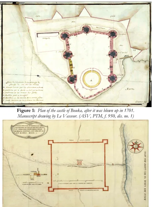
The demolition of the castle of Bouka occurred in the summer of 1701, two and a half years after the Treaty of Karlowitz and one year after the bilateral agreement of Constantinople of 12 June 1700, which settled the border-line disputes. The castle’s blow-up lasted thirty days and the results of the explosions were recorded on a report of the proveditor-general at sea Daniel Dolfin IV, written on 22 August 1701. A detailed plan of the castle, drawn by the engineer Le Vasseur and attached to this report, illustrates the destruction that occurred (Fig. 1).3
The New Castle at Chiparissi
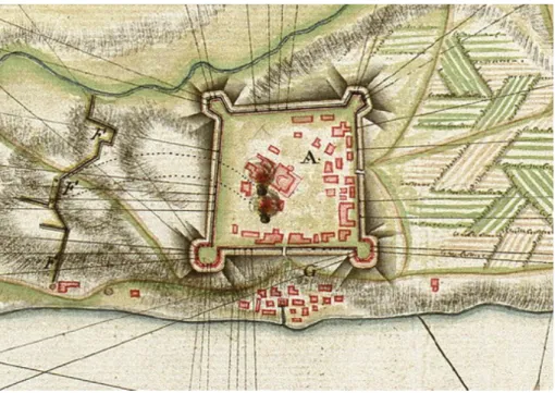
Immediately after the demolition of the castle of Bouka, the Venetians handed over the area to the Ottomans, who started constructing a large castle in order to defend Preveza and the straits of the Gulf of Arta. The new stronghold was built one kilometre north of the demolished castle, at a distance of a cannon-shot from it. Much information about this defensive work is derived from another report by the same proveditor-general at sea, Daniel Dolfin IV, written on 21 August 1702, as well as a plan of the new castle, drawn by the engineer Gregorio Dir and attached to the report (Fig. 2).4
The new Ottoman fortification of Preveza was built at the site called “Sto
Chiparissi” (“At the Cypress”), probably so named after a big cypress tree which
might have stood there. We believe that the Ottomans took advantage of a natural projection of the earth, a ridge, that exists in that part of Preveza, dug out the relevantly soft red soil of the area, where needed, in order to create a defensive moat and, thus, formed a large earthen castle. Four simple tower-like
3 ASV, PTM, f. 950, design no. 1. Cf. Ioanna Steriotou, “L’ importanza militare del
golfo di Amvrakikos (fine del XVII - XVIII sec.). Informazioni sulle fortificazioni e dati strategici dagli archivi veneziani”, I Greci durante la venetocrazia: Uomini, spazio, idee (XIII - XVIII sec.), Venezia 2009, pp. 568, 571, 815; Nikos D. Karabelas, “The castle of Bouka (1478-1701). Fortified Preveza through sources”, Preveza B. Proceedings of the Second International Symposium for the History and Culture of Preveza (16-20 September 2009), Preveza 2010, vol. I, pp. 411-412, where the results of the demolition are mentioned.
4 ASV, PTM, f. 951, report no. 39 (21.8.1702) and design no. 1. Thanks are owed to
the State Archives of Venice for their permission to reproduce archival material. For the transcription of the legends of the plan see Appendix I. Another report (Relation) informs us that the new castle was built at a distance of half a mile from the demolished Bouka castle; see Thomas von Wiering (Ed.), Ausführliche Relation von Eroberung der Türckischen Fortressen Prevesa und Vonitza, durch die Waffen der Republiq Venedig / unter tapfferer Anführung des Admirals oder General-Kapitains / und nunmehro mit der Ritter-Würde beehrten Herrn Andreæ Pisani. Aus dem zu Venedig gedruckten Exemplar übersetzt, Hamburg 1717, p. 1; Demosthenes Donos, “The Venetian capture of Preveza and Vonitsa in 1717, according to the German translation of the Italian relazione”, Πρεβεζάνικα Χρονικά, Vol. 41-42, Preveza 2005, p. 16. The distance between the centres of the two castles was 1050 m. The gap between the nearest bastions of the two castles was 790 m.
bastions were constructed, one at each corner of the castle, at least two of which were overlaid externally with stone.5
According to Dir’s plan, the castle had a perfectly square shape and four square bastions, one at each corner. The length of each curtain, façade wall, (cortina in Italian) measured 120 Venetian passi, i.e. about 210 metres. Each side of the square bastions measured about 25 metres, thus making the length of each side of the castle, from bastion to bastion, about 260 metres.6
From the detailed profile view of the castle (Fig. 3), which appears in the above mentioned plan drawn by Gregorio Dir, we can deduce that the fortification was a simple construction, consisting of a rather small stone wall (Muro), 3 Venetian feet [1.04 m] tall by 5 feet [1.74 m] wide.7 Wooden poles (Pali), 8 feet [2.78 m] tall, were embodied into the wall. These poles exceeded 5 feet [1.74 m] from the stone wall. An earthen buttress (Terrapien) was formed outside the stone wall, using soil dug out from the moat. It was almost 5 feet [1.74 m] wide, 4 feet [1.39 m] tall in the exterior façade, and 5 feet [1.74 m] tall towards the stone wall. A corridor was, thus, created onto the stone wall, between the wooden poles and the earthen buttress. A defensive moat (Fossa) was dug outside the fortification; it was 6 feet [2.09 m] deep, 5 feet [1.74 m] wide at the top, 3 feet [1.04 m] wide at the bottom, and contained water.
According to Daniel Dolfin IV, the fortification was reported to be weak and it would definitely wear down in time. The proveditor-general also revealed that the castle was vulnerable to organized military attacks, because of its small-sized moat, short buttresses, and simple pole-fenced wall. If the castle had to be
5 Two academics have studied, in some depth, the fortifications of Preveza to date;
Professor Giorgos Velenis and Dr. Giorgos Smyris. The former, in a research program about the history of Preveza’s monuments which focused on the castle of Pantokrator, see Georgios Velenis, , Thessaloniki 1991. The latter, in a detailed account of the fortifications in the pashalic of Jannina from 1788 to 1822, see Giorgos Smyris, Το ∆ίκτυο των οχυρώσεων στο ̟ασαλίκι των Ιωαννίνων (1788-1822), Ioannina 2004. None of the two mentioned anything about the first, Ottoman, phase of the castle that we present in this article, despite the fact that, at least, the former had access to several plans of the fortification from the Venetian Archives, which could have led in such a result, see Georgios Velenis, Ιστορική Έρευνα των Μνηµείων της Πρέβεζας. Το Κάστρο του Παντοκράτορα, Thessaloniki 1991, pp. 36-37, and fig. 12; Anna Triposkoufi & Amalia Tsitouri (Eds.), Ενετοί και Ιωαννίτες ι̟̟ότες. ∆ίκτυα οχυρωµατικής αρχιτεκτονικής, Athens 2001, pp. 125-128; Giorgos Smyris, Το ∆ίκτυο των οχυρώσεων στο ̟ασαλίκι των Ιωαννίνων (1788-1822), Ioannina 2004, pp. 93-94, 100-102.
6 Each Venetian or Geometrical pace (passo) measures 1.74 metres; see Ioanna
Steriotou, Οι βενετικές οχυρώσεις του Ρεθύµνου (1540-1646). Συµβολή στη φρουριακή αρχιτεκτονική του 16ου και του 17ου αιώνα, Athens 1992, vol. I, pp. 271, 273.
improved, he advised for the construction of a larger moat and stronger bastions, an advice which was implemented by the Venetians almost twenty years later.8
The castle covered an area of more than 44,000 square metres and there were two roads leading to it, passing through equal number of gates in the middle of the north and south wall of the castle respectively. The road from Preveza to Arta was passing through the north gate. From the south gate the road was leading to the old town of Preveza and the demolished castle of Bouka. At the centre of the new fortress there was a mosque (moschea). A watermill (molino) was standing outside the east wall of the fortification and during winter it operated by the motion of the waters of a stream (fosso di acqua) which was passing through the fort and emptying into the gulf of Preveza.
As the new castle became the centre of everyday life and a safeguard for the local people, the Prevezans started building their new houses closer to it, thus starting to shift the town towards the north. Based on this evidence, we can support that from 1702 onwards New Preveza was eventually formed close to and mainly south of the new castle in contrast with old Preveza which had evolved, since 1478, close to and north of the then newly built castle of Bouka.9 This shifting of Preveza is confirmed by reports and accounts of military
8 For the first widening of the moat by 3 Venetian feet (piedi) [1.04 m], see the legend
of a plan, held in the Venetian State Archives, entitled Pianta di Prevesa, described below; ASV, PF, busta ex b. 79, design no. 36b (Fig. 9).
9 For the construction of the castle of Bouka, in 1478, and the new settlement that
evolved next to it, see Nikos D. Karabelas, “The castle of Bouka (1478-1701). Fortified Preveza through sources”, Preveza B. Proceedings of the Second International Symposium for the History and Culture of Preveza (16-20 September 2009), Preveza 2010, vol. I, pp. 400-402, 413; Demosthenes Donos, “Observations on the urban development of Preveza during the 17th and 18th centuries”, Preveza B. Proceedings of the Second International Symposium for the
History and Culture of Preveza (16-20 September 2009), Preveza 2010, vol. I, p. 436; Stavros Mamaloukos, “The Domestic Architecture in the city of Preveza until the mid 20th
century”, Preveza B. Proceedings of the Second International Symposium for the History and Culture of Preveza (16-20 September 2009), Preveza 2010, vol. II, pp. 253, 262; Nikos D. Karabelas, “The Ottoman conquest of Preveza and its first castle”, XVI. Türk Tarih Kongresi (Ankara, 20-24 Eylül 2010), Ankara [2014] (to be published), p. [11]. For the shifting of the town northwards, nearer to the new castle, see Stavros Mamaloukos, “The city of Preveza. Urban evolution and architecture”, Nicopolis - Preveza. The collection of Nikos D. Karabelas and other private archives, Preveza 1996, p. [14]; Nikos D. Karabelas, “The castle of Bouka (1478-1701). Fortified Preveza through sources”, Preveza B. Proceedings of the Second International Symposium for the History and Culture of Preveza (16-20 September 2009), Preveza 2010, vol. I, pp. 412-413; Demosthenes Donos, “Observations on the urban development of Preveza during the 17th and 18th centuries”, Preveza B.
Proceedings of the Second International Symposium for the History and Culture of Preveza (16-20 September 2009), Preveza 2010, vol. I, p. 440;
operations that took place in this region during the seventh Ottoman-Venetian war, written almost two decades after the castle at Chiparissi was built.10
The second Ottoman period of Preveza did not last long. Venetian forces, under the command of marshal Johann Matthias Graf von der Schulenburg and admiral Andrea Pisani, attempted, in late October 1716 and a few days after recapturing St. Maura, to seize the castle of Preveza, as the fortress “Sto
Chiparissi” was known by then. At the time, Preveza was defended by 400-500
soldiers and 30 artillery guns. While the Venetian fleet was passing through the straits of Preveza, the Ottoman forces fired with their artillery heavily against it and succeeded in deterring the Venetians from capturing the castle. The latter managed to enter into the Gulf of Arta and attempted, without success, to seize the castle of Vonitsa.11
This incident was depicted by the Corfiot captain of the Venetian navy Antonio Paravia (1754-1828) in a drawing included in his manuscript portfolio surviving today in the collections of the Correr Museum in Venice (Fig. 4).12 A large galleon (galeotta) and 17 galleys are pictured in this drawing entering the straits of Preveza, accompanied by as many as 36 smaller boats, while 7 more boats are depicted separately, in the bottom right-hand corner of the drawing, as if they had already entered the Gulf. This depiction almost perfectly matches marshal Schulenburg’s description of the same event, presented in his Memoirs, which were published post mortem.13 According to him, on October 21st, six
10 See for example Paravia, p. 358 and his reference to Prevesa vecchia in the manuscript
plan fp. 359; [Friedrich Albrecht Graf von der] Schulenburg, Leben und Denkwürdigkeiten Johann Mathias Reichsgrafen von der Schulenburg, Erbherrn auf Emden und Delitz, Feldmarschalls in Diensten der Republik Venedig. Aus Original-Quellen bearbeitet, Libzig 1834, vol. II, p. 91.
11 See [Friedrich Albrecht Graf von der] Schulenburg, Leben und Denkwürdigkeiten
Johann Mathias Reichsgrafen von der Schulenburg, Erbherrn auf Emden und Delitz, Feldmarschalls in Diensten der Republik Venedig. Aus Original-Quellen bearbeitet, Libzig 1834, vol. II, pp. 91-92; Demosthenes Donos, “The war of words and pictures. Evidence for the Venetian operations in the Gulf of Arta, during the years 1716 and 1717”, Πρεβεζάνικα Χρονικά, Vol. 47-48, Preveza 2011, pp. 55, 81-82.
12 Paravia, f.p. 358; manuscript drawing titled: Vue de Prevesa vers Levant. an. 1716.
Antonio Paravia’s memoirs, written, by form of letters, during the second half of the 18th century, were compiled into his 6-volume portfolio a couple of years before 1800;
cf. Guido Amoretti, La Serenissima Repubblica in Grecia, XVII-XVIII Secolo. Dalle tavole del Capitano Antonio Paravia e dagli archivi di Venezia, Torino 2006. We believe that Antonio Paravia, apart from his own knowledge and life-long experience, had access to similar material that existed in Venetian authorities and archives, some of which he most probably copied in his portfolio.
13 See [Friedrich Albrecht Graf von der] Schulenburg, Leben und Denkwürdigkeiten
Johann Mathias Reichsgrafen von der Schulenburg, Erbherrn auf Emden und Delitz, Feldmarschalls in Diensten der Republik Venedig. Aus Original-Quellen bearbeitet, Libzig
light ships entered into the Gulf of Arta, but it was only until October 24th that the rest of the fleet managed to enter the straits of Preveza, due to bad weather. Whilst under heavy gun-fire from the castle of Preveza, 17 galleys, one galleon and 40 to 50 small boats managed with difficulty to pass the straits and enter the Gulf to Vonitsa.14
In the same drawing, the new castle of Preveza is depicted as if it were on fire (Fig. 5). The castle appears to be earthen, with two stone-built bastions and pole-fenced walls in its eastern side, thus confirming the information provided by the plan of Gregorio Dir. The mosque in the middle of the fortress and a few buildings inside it can also be seen in Paravia’s drawing.
The Castle under the Venetian Attack of 1717
The Venetian’s first, unsuccessful, attempt to capture the strongholds of Preveza and Vonitsa was followed by another, one year later, under the same military leaders. This second attack was organized more carefully and resulted in seizing both castles on 22 October and 2 November 1717 respectively.15
There exist a number of 18th century archival documents from different sources referring to the Venetian attack of 1717, which provide us the main characteristics of Preveza’s new castle. We have chosen the four most revealing drawings to convey information about the situation of the castle at the time.16
1834. Despite the fact that the compiler of the work is not clearly mentioned, it is Friedrich Albrecht Graf von der Schulenburg-Klosterroda (1772-1853) who edited these two volumes and published them 87 years after the death of his ancestor, marshal Schulenburg (1661-1747).
14 For a detailed discussion about the operations of October 1716, see Demosthenes
Donos, “The war of words and pictures. Evidence for the Venetian operations in the Gulf of Arta, during the years 1716 and 1717”, Πρεβεζάνικα Χρονικά, Vol. 47-48, Preveza 2011, pp. 46-47, 55-59.
15 For a detailed account of the operations in Preveza and Vonitsa during late October
and early November 1717, see Demosthenes Donos, “The Venetian capture of Preveza and Vonitsa in 1717, according to the German translation of the Italian relazione”, Πρεβεζάνικα Χρονικά, Vol. 41-42, Preveza 2005, pp. 23-41; Demosthenes Donos, “The war of words and pictures. Evidence for the Venetian operations in the Gulf of Arta, during the years 1716 and 1717”, Πρεβεζάνικα Χρονικά, Vol. 47-48, Preveza 2011, pp. 59-65.
16 Apart from the four plans, described below, useful information about the castle in
1717 can be found in the following manuscript plans: a) ASV, PF, busta ex b. 79, design no. 36a, reproduced in Nikos D. Karabelas, In Charta. Prints of Preveza, Preveza 2006, No.11; b) HStAM, WHK, no. 17/36 & no. 17/36aa, drawn by the engineer H.C. Bröckell, reproduced in Demosthenes Donos, “The war of words and pictures. Evidence for the Venetian operations in the Gulf of Arta, during the years 1716 and 1717”, Πρεβεζάνικα Χρονικά, Vol. 47-48, Preveza 2011, p. 56, fig. 3; c) HStAM, WHK, no. 17/36a, obviously a copy of (a) above, reproduced in Demosthenes Donos, ibid, p.
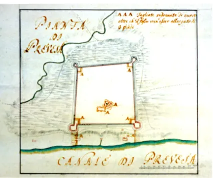
The first is a manuscript plan of the castle during the Venetian offence of October 1717 –from now on to be referred as A– which is held at the State Archives of the German city of Marburg (Fig. 6);17 the second is a view of the castle from the east while it was bombed by the Venetian forces, held at the same archive (Fig. 7), from now on to be referred as B;18 the third is a plan of the castle under fire, held at the Military Archives of Stockholm, Sweden (Fig. 8), from now on to be referred as C;19 and the fourth is a simple plan of the castle –drawn, to our belief, a year or two after 1717 but before the fortification’s major alterations realized by the Venetians– held at the State Archive of Venice (Fig. 9), from now on to be referred as D.20
All four of the above mentioned manuscript drawings indicate that in 1717 the castle still had earthen buttresses. The two eastern bastions are confirmed to be stone-built. The other two bastions, on the western side of the castle, seem to be earthen and of smaller size, probably because the likelihood of an attack from the west was less than from the sea side in the east. A number of houses had been built inside the castle by 1717, mostly situated towards its two gates (northern and eastern), as seen in A and C (Figs. 6 & 8). The mosque is standing almost in the centre of the fort, as seen in A and B (Figs. 6 & 7). The gate in the southern wall of the castle, which appeared in the plan of 1702 by Gregorio Dir (Fig. 2), seems not to exist in 1717. A few structures appear east of the eastern gate, amongst which seems to be a water mill or a fountain with a
61, fig. 4; d) HStAM, WHK, no. 17/38ab, attributed to H.C. Bröckell, reproduced in Demosthenes Donos, ibid, p. 68, fig. 6.
17 HStAM, WHK, no. 17/37. Unknown designer. The title of the plan is: Pianta del attaco di
Prevesa con il Golfo e suoi contorni, e, Campamento attacato al ottob: 19: 1717. It was presented for the first time in Demosthenes Donos, “The war of words and pictures. Evidence for the Venetian operations in the Gulf of Arta, during the years 1716 and 1717”, Πρεβεζάνικα Χρονικά, Vol. 47-48, Preveza 2011, pp. 63, 95. We believe that it was created a few years after the attack of 1717, by copying a similar manuscript in the Venetian archives.
18 HStAM, WHK, no. 17/37. Unknown designer. The view appears in the upper
right-hand corner of the above mentioned plan and is titled: Veduta di Prevesa da Ostro. Thanks are owed to the State Archives of Marburg, Hessen, Germany, for their permission to reproduce their archival material (Permit no.: M 6.1.2.000-03777).
19 KuK, XIV A, nr. 10 S. Drawn by J.E. Randahl in 1747. The title of the manuscript
plan is: Le Plan de Prevesa. | 1717. le 21. Oct. It was presented for the first time in Nikos D. Karabelas, “The castle of Bouka (1478-1701). Fortified Preveza through sources”, Preveza B. Proceedings of the Second International Symposium for the History and Culture of Preveza (16-20 September 2009), Preveza 2010, vol. I, pp. 413, 432. For the transcription of the legend of the plan see Appendix II.
20 ASV, PF, busta ex b. 79, design no. 36b. The title of the manuscript plan is: Pianta di
Prevesa. It was presented for the first time by Georgios Velenis, Ιστορική Έρευνα των Μνηµείων της Πρέβεζας. Το Κάστρο του Παντοκράτορα, Thessaloniki 1991, pp. 36-37, and fig. 12. For the transcription of the legend of the plan see Appendix III.
small stream depicted, as seen in A and D (Figs. 6 & 9), to start from it and empty into the sea, thus confirming the similar information given by Daniel Dolfin in 1702.
The road to Arta still passed through the north gate, at the centre of the northern wall. By 1717, a new gate had been created in the middle of the eastern wall, as seen in all four drawings. This is the main entrance to the castle even today, despite the alterations that were effected upon it during the second Venetian period (1717/8-1797) and the second period of Ali pasha of Jannina (1806-1820). Two roads started from this eastern gate; one leading towards the north and the second towards the south.
The former, (G) in drawing A (Fig. 6), is indicated as the road taken by the Ottomans when they fled the castle in the night of 21 October 1717. We believe that this is the seaside road leading to the safe from all winds port of Vathy and from there to the Mazoma lagoon.21
The latter, obviously, led to the old town of Preveza, next to the demolished castle of Bouka. The road passed over the small river of Preveza -later known as Kouradas or Karydas– via a bridge which is depicted in B (Fig. 7) and drawn in A.22 The bridge existed at the same place in April 1685, when the Venetian engineer G.L. Mauro delineated this area of Preveza.23 The region where the bridge stood, was known, during the 19th century, as Gefyropoulo (Little bridge).
Plans A, C and D (Figs. 6, 8, 9) indicate that the south-western bastion of the castle is near to the course of Preveza’s Kouradas river, which today runs arranged underneath the main Irinis avenue of Preveza and turns underneath
Karyotaki street to empty into the old harbour of the city.
The Venetians, immediately after taking Preveza from the Ottomans, widened the surrounding moat by three Venetian feet (piedi) [1.04 m], as denoted in plan D (Fig. 9).24 They, also, converted the Muslim mosque in the centre of the castle into a Catholic church, probably in honour of St. Andrew, the patron saint of admiral Andrea Pisani, who captured the town on 22
21 For this seaside road leading from Preveza to the Ottoman State through the
Mazoma lagoon, see James S. Curlin & Nikos D. Karabelas, “Adi 31 Agosto 1797-A dispute in the Venetian-Ottoman border of Preveza”, Proceedings of the 10th National
Cartographic Conference (Ioannina 2008), Thessaloniki 2010, p. 116.
22 For plan A in its entirety, see Demosthenes Donos, “The war of words and pictures.
Evidence for the Venetian operations in the Gulf of Arta, during the years 1716 and 1717”, Πρεβεζάνικα Χρονικά, Vol. 47-48, Preveza 2011, p. 63, fig. 5.
23 For a detailed description of the plan by Giovanni Leonardo Mauro, see Nikos D.
Karabelas, “The castle of Bouka (1478-1701). Fortified Preveza through sources”, Preveza B. Proceedings of the Second International Symposium for the History and Culture of Preveza (16-20 September 2009), Preveza 2010, vol. I, pp. 409-411, 414-415.
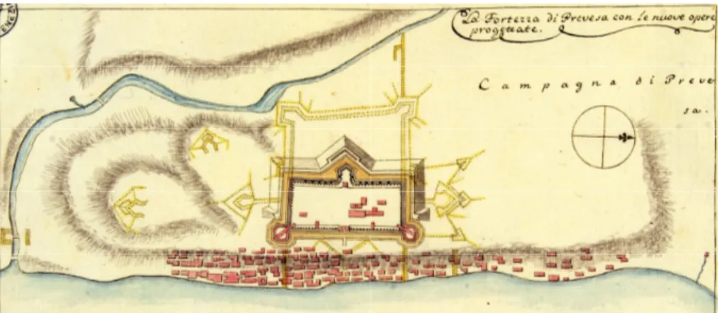
October 1717.25 During the following years, the Venetians materialized further improvements and alterations to the shape and size of St. Andrew’s fort, as the castle at Chiparissi was thereafter known. Its defensive capacity was improved, amongst other, by reducing its size to almost half and constructing a new moat as well as a large triangular bastion in its western side, as indicated in a manuscript plan by Antonio Paravia (Fig. 10).26 But this is beyond the scope of our present article and a challenge for new research.
Comparisons and Conclusions
We tried to place the castle at Chiparissi within the context of the present topography and to do so we superimposed Gregorio Dir’s plan onto a same scale satellite map of modern Preveza (Fig. 11). We have thus determined the extent of Preveza’s Ottoman fortification of 1702. It is worth noting that the old road, which started from the middle of the northern wall and led towards Arta, coincides with today’s Markou Botzari street. The site where the mosque stood, in the centre of the castle’s first phase, is still traceable, since on the same position there still exists the building of St. Andrew’s Catholic church, which was transformed into a powder magazine during Ali pasha’s rule. We, also, note that in the position where the watermill of the 18th century stood, there is, even today, a spring of fresh water, which for decades supplied the water fountain that existed east of the big mosque of Preveza, built by Ali pasha of Jannina. Today, the source of water continues to spring underneath the Municipal Cultural Centre.
In conclusion, after the demolition, in 1701, of the castle of Bouka, the second Ottoman fortification of Preveza was built, at the site called “Sto
Chiparissi”, which over the next centuries evolved into what we now know as
the castle of St. Andrew. The initial, simple, construction of 1702 was improved, after the town was captured by the Venetians, in 1717. Despite the major alterations which the castle underwent over a period of more than 100 years, its eastern wall and the position of both its eastern bastions have not changed much.
25 See Demosthenes Donos, “The Venetian capture of Preveza and Vonitsa in 1717,
according to the German translation of the Italian relazione”, Πρεβεζάνικα Χρονικά, Vol. 41-42, Preveza 2005, p. 32; Demosthenes Donos, “The war of words and pictures. Evidence for the Venetian operations in the Gulf of Arta, during the years 1716 and 1717”, Πρεβεζάνικα Χρονικά, Vol. 47-48, Preveza 2011, pp. 61-62.
26 Paravia, f.p. 359; manuscript drawing titled: La Fortezza di Prevesa con le nuove opera
progettate. Cf. Guido Amoretti, La Serenissima Repubblica in Grecia, XVII-XVIII Secolo. Dalle tavole del Capitano Antonio Paravia e dagli archivi di Venezia, Torino 2006, p. 152.
Appendix I.
Transcription of the legend in the manuscript plan by Gregorio Dir, attached to the report no. 39, written on 21.8.1702, by Daniel Dolfin IV; held at ASV, PTM, f. 951, dis. no.1. (Fig. 2)
Dimensions: 28x39 cm.
Nuova eretione di fabrica, che vano | costruendo li Turchi nel sito deto | sto Chiparissi, in distanza della | demolita Prevesa a un tiro di ca | non in circa. MDCCII.
Porta verso l’ Arta.
Porta verso la demolita Prevesa
Fosso di acqua, che l’ inverno fa macinar il molino A A [molino] Fosso di acqua. Moschea. Esterior Fossa Terrapien Pali Muro Interior
Bocca del canal va nel Golfo del Arta
Scala di passi. CXX. per la pianta qui espresso. Scala di piedi. XXX. per il profilo.
Appendix II.
Transcription of the legend in the manuscript plan by J.E. Randahl, drawn in 1747; held at KuK, XIV A., nr.10 S. (Detail in Fig. 8)
Dimensions: 24x38 cm.
Le Plan de Prevesa. | 1717. le 21. Oct.
Esquadron de Dragons. Campement des Esclavons.
800 Hommes fous les Armees.
Chemin vers L’ Arta que les Infideles ont pries dans leur fuite. L’ hauteur Mehemet Effendi.
Camp des Allemands. Prevesa Vieille. Attaque. Attaque.
Canal de Prevesa ou d’ Arte.
Appendix III.
Transcription of the legend in the manuscript plan by unknown creator; held at ASV, PF, busta ex b. 79, dis. no. 36b. (Fig. 9)
Dimensions: 26x30 cm.
Pianta di Prevesa
AAA Tagliate ordonnate da nuovo | oltre ch’ il fosso vien’esser allargato di | 3 piedi
Canale di Prevesa
There is a scale of 110 passi, which is the average length of the buttresses of the castle.
Sources
ASV, PF: Archivio di Stato di Venezia, Provveditori alle Fortezze, Venice, Italy. ASV, PTM: Archivio di Stato di Venezia, Dispacci di provveditori da Terra e da
Mar ed altre cariche, Venice, Italy.
HStAM, WHK: Hessisches Staatsarchiv Marburg, Wilhelmshöher Kriegskarten, Marburg, Germany.
KuK: Krigsarkivet, Utländska Krigsplaner, Stockholm, Sweden.
Paravia, Biblioteca del Museo Civico Correr di Venezia, Provenienze Diverse
241b, Antonio Paravia, Mio portafogli di viaggi, osserervazioni, memorie, e
frammenti istorici del mio tempo. Parte prima. Dall’anno 1754 fino al 1774. List of works cited
ABOU-EL-HAJ, Rifaat A., “Ottoman diplomacy at Karlowitz”, Journal of the
American Oriental Society, Vol. 87, No. 4 (Oct. - Dec. 1967), New
Haven 1967, pp. 498-512.
ABOU-EL-HAJ, Rifaat A, “The formal closure of the Ottoman frontier in Europe: 1699-1703”, Journal of the American Oriental Society, Vol. 89, No. 3 (Jul. - Sep. 1969), New Haven 1969, pp. 467-475.
AMORETTI, Guido, La Serenissima Repubblica in Grecia, XVII-XVIII Secolo.
Dalle tavole del Capitano Antonio Paravia e dagli archivi di Venezia, Torino 2006.
CURLIN, James S.-Nikos D. Karabelas, “Adi 31 Agosto 1797- A dispute in the Venetian-Ottoman border of Preveza”, in: Angeliki Tsorlini (Ed.),
Proceedings of the 10th National Cartographic Conference (Ioannina 2008), Thessaloniki 2010, pp. 111-140.
DONOS, Demosthenes, “The Venetian capture of Preveza and Vonitsa in 1717, according to the German translation of the Italian relazione” [in Greek],
Πρεβεζάνικα Χρονικά, Vol. 41-42, Preveza 2005, pp. 6-44.
DONOS, Demosthenes, “Observations on the urban development of Preveza during the 17th and 18th centuries” [in Greek with English abstract], in: Marina Vrelli-Zachou & Christos Stavrakos (Scient. Eds.), Preveza B.
Proceedings of the Second International Symposium for the History and Culture of Preveza (16-20 September 2009), Preveza 2010, vol. I, pp. 435-459.
DONOS, Demosthenes, “The war of words and pictures. Evidence for the Venetian operations in the Gulf of Arta, during the years 1716 and 1717” [in Greek], Πρεβεζάνικα Χρονικά, Vol. 47-48, Preveza 2011, pp. 42-101.
KARABELAS, Nikos D., “The castle of Bouka (1478-1701). Fortified Preveza through sources” [in Greek with English abstract], in: Marina Vrelli-Zachou & Christos Stavrakos (Scient. Eds.), Preveza B. Proceedings of the
Second International Symposium for the History and Culture of Preveza (16-20 September 2009), Preveza 2010, vol. I, pp. 395-433.
KARABELAS, Nikos D., “The Ottoman conquest of Preveza and its first castle”, in: XVI. Türk Tarih Kongresi : Kongreye sunulan bildiriler : Ankara,
20-24 Eylül 2010, Ankara [2014] (to be published).
MAMALOUKOS, Stavros, “The city of Preveza. Urban evolution and architecture”, in: Nikos D. Karabelas (Ed.), Nicopolis - Preveza. The
collection of Nikos D. Karabelas and other private archives, Preveza 1996, n.pag.,
[14-19].
MAMALOUKOS, Stavros, “The Domestic Architecture in the city of Preveza until the mid 20th century” [in Greek with English abstract], in: Marina Vrelli-Zachou & Christos Stavrakos (Scient. Eds.), Preveza B. Proceedings of
the Second International Symposium for the History and Culture of Preveza (16-20 September 2009), Preveza 2010, vol. II, pp. 251-278.
SAVVIDES, Alexis G.K., “On the Turkish conquest of Preveza according to the Kleinchroniken” [in Greek with English abstract], in: Vaggelis G. Avdikos (Ed.), The History of Preveza. Proceedings of the 1st International Symposium, (22-24 September 1989), Preveza 1993, pp. 25-41.
STERIOTOU, Ioanna, Οι βενετικές οχυρώσεις του Ρεθύµνου (1540-1646).
Συµβολή στη φρουριακή αρχιτεκτονική του 16ου και του 17ου αιώνα, vol. Ι-ΙΙ, Athens 1992.
STERIOTOU, Ioanna, “L’ importanza militare del golfo di Amvrakikos (fine del XVII - XVIII sec.). Informazioni sulle fortificazioni e dati strategici dagli archivi veneziani”, in: Ch. Maltezou, A. Tzavara & D. Vlassi (Eds.), I Greci durante la venetocrazia: Uomini, spazio, idee (XIII -
XVIII sec.), Venezia 2009, pp. 563-572 & 815-816.
[Friedrich Albrecht Graf von der] Schulenburg, Leben und Denkwürdigkeiten
Johann Mathias Reichsgrafen von der Schulenburg, Erbherrn auf Emden und Delitz, Feldmarschalls in Diensten der Republik Venedig. Aus Original-Quellen bearbeitet, vol. Ι-ΙΙ, Libzig 1834.
SMYRIS, Giorgos, Το ∆ίκτυο των οχυρώσεων στο ̟ασαλίκι των Ιωαννίνων
(1788-1822), Ioannina 2004.
TRIPOSKOUFI, Anna-Amalia Tsitouri (Eds.), Ενετοί και Ιωαννίτες ι̟̟ότες.
VELENIS, Georgios, Ιστορική Έρευνα των Μνηµείων της Πρέβεζας. Το Κάστρο
του Παντοκράτορα, Thessaloniki 1991. [Research programme No. 2395
of the Aristotle University of Thessaloniki, partially published in
Πρεβεζάνικα Χρονικά from 1995 to 1999].
Thomas von Wiering (Ed.), Ausführliche Relation von Eroberung der Türckischen
Fortressen Prevesa und Vonitza, durch die Waffen der Republiq Venedig / unter tapfferer Anführung des Admirals oder General-Kapitains / und nunmehro mit der Ritter-Würde beehrten Herrn Andreæ Pisani. Aus dem zu Venedig gedruckten Exemplar übersetzt, Hamburg 1717.
Figures:
Figure 1: Plan of the castle of Bouka, after it was blown up in 1701. Manuscript drawing by Le Vasseur. (ASV, PTM, f. 950, dis. no. 1)
Figure 2: Plan of the castle of Preveza, built by the Ottomans in 1702. Manuscript drawing by Gregorio Dir. (ASV, PTM, f. 951, dis. no. 1)
Figure 3: Profile view of the castle of Preveza, built in 1702. Detail of the drawing by Gregorio Dir. (ASV, PTM, f. 951, dis. no. 1)
Figure 4: The Venetian fleet passing the straits of Preveza in 1716. Manuscript drawing by Antonio Paravia. (Amoretti 2006, p. 154)
Figure 5: The castle of Preveza, under fire, in 1716. View from the east. Note the earthen, pole-fenced wall, the stone-built bastions, and the mosque. Detail of the manuscript drawing by Antonio Paravia. (Paravia, fp. 358)
Figure 6: Plan of the castle of Preveza, under fire, in 1717. (A) Note the two larger, eastern, stone-built bastions, and the mosque. Detail of a manuscript drawing from the Marburg Archives. (WHK 17/37)
Figure 7: The castle of Preveza, under fire, in 1717. View from the east. (B) Note the earthen wall, the two stone-built bastions, and the mosque. Detail of a manuscript drawing from the Marburg Archives. (WHK 17/37)
Figure 8: Plan of the castle of Preveza, under fire, in 1717. (C) Note the two larger, eastern, stone-built bastions, and the two gates. Detail of a manuscript drawing from the Military Archives of Stockholm.
(K.u.K., XIV A., nr. 10 S)
Figure 9: Plan of the castle of Preveza, after 1717. (D) (ASV, PF, busta ex b. 79, dis. no. 36b) (Velenis 1991, Fig. 12)
Figure 10: The Venetian proposals for improving St. Andrew’s castle. Manuscript drawing by Antonio Paravia. (Amoretti 2006, p. 152)
Figure 11: The castle’s position within the context of the present topography by superimposing Gregorio Dir’s plan of 1702 on a satellite image of 2012.