THE KONYA FAULT ZONE Rahmi AKSOY and Yaşar EREN
S.Ü. Mühendislik-Mimarlık Fakültesi, Jeoloji Mühendisliği Bölümü, Konya-TURKEY Makalenin Geliş Tarihi: 17.09.2004
ABSTRACT: The Konya fault zone is a northeast-southwest trending, east-dipping normal slip fault in the western part of the Konya city, extending for about 65 km from the east of Hatunsaray northeastward to the east of Doğudağ. The fault zone includes subparallel branching faults that lie within a linear belt, as much as 5 km in width. Study of exposures in a road-cut across the fault zone demonstrates recurrent Quaternary faulting. Three events have been identified but not yet dated. Evidence of prehistoric events includes development of cracks and veins in the sedimentary units, faults that are covered by sediments that accumulated after the faults slipped and sedimentary units and their faulted relationship. The area where the fault is exposed is characterized by a unique set of stratigrafic and geomorphic relationships that may document the late Pleistocene and Holocene movement of the Konya fault zone.
Key words: Konya Fault Zone, normal slip fault, neotectonic,
Konya Fay Zonu
ÖZET: Konya fay zonu, Konya batısında kuzeydoğu-güneybatı uzanımlı, doğuya eğimli, eğim atımlı normal faylar ile temsil edilir. Fay zonu yaklaşık 65 km uzunluğa sahip olup, Hatunsaray doğusundan başlayarak kuzeydoğuya Doğudağ doğusuna doğru uzanır. Fay zonu 5 km genişliğinde bir takım süreksiz, birbirlerine az çok paralel faylardan oluşmaktadır. Fay zonu içinde yer alan bir yol yarmasındaki yüzleklerin incelenmesi sonucunda fay zonunun tekrarlanan Kuvaterner yapılarını sergilediği görülmüştür. Burada henüz yaşlandırılamayan üç sismik olay belirlenmiştir. Kuvaterner birimleri içinde görülen yarık ve çamur daykları, fayların faylanmadan sonra çökelen sedimanlarca örtülmesi ve faylanmış sedimanter birimler ve ilişkileri söz konusu sismik olayların tarih öncesi delillerini oluştururlar. Fayın yüzeylediği yerler, fay zonunun Pleyistosen ve Holosen aktivitesini belgeleyen stratigrafik ve morfolojik ilişkilerle karekterize olunmaktadır.
Anahtar kelimeler: Konya Fay Zonu, eğim atımlı normal fay, neotektonik.
INTRUDUCTION
The western part of the Konya city is determined by the long linear northeast-trending ridges. These ridges consist of different rock units of Silurian to lower Pliocene age. The east of these ridges forms the part of the Konya depression. This part of the depression is filled with upper Miocene-lower Pliocene fluviolacustrine and Quaternary alluvial sediments. The Konya fault zone trends through the eastern front of the ridges and then enters the Konya basin in the northeast. It extends a
distance of about 65 km from east of Hatunsaray in the south to the eastern end of Doğudağ in the north (Figure 1, 2).
The Konya fault zone is well-expressed geomorphically as a set of discontinuous zone of surface faulting represented by offset Quaternary deposits and young-looking fault features such as scarps, deflected streams, linear ridges and lines of springs. The fault zone comprises a set of northeast-trending faults. Although previous workers (Koçyiğit, 1984; Özcan et al., 1990, Koçyiğit et al., 2000) depicted the zone as single through going fault, in this
study it is first time called as the “Konya fault zone” due to the lack of continuity of any single fracture through the whole length of the zone. The dominant structural element in the Konya region is dip-slip faults that are responsible for the neotectonics and present-day physiography.
Figure 1. Index map showing the location of the study area.
Şekil 1. İnceleme alanının yer bulduru haritası.
The late Cenozoic tectonic history of the western part of Konya is marked by several periods of different faulting styles that were initiated in the beginning of late Miocene. Prior to this time, the region had low relief and served as a sediment source for the former Konya Lake (Roberts, 1983). This low-relief surface was disrupted during late Miocene to early Pliocene and Quaternary time interval by normal faulting that was probably related to interplate extension (Şengör, 1980; Koçyiğit, 1984; Toprak and Göncüoğlu, 1993; Koçyiğit and Beyhan, 1998, Koçyiğit etal., 2000).
Concerning the earthquake activity of Turkey, the Konya region takes place in the fourth degree earthquake zone based on earthquake risk (Ministry of Public Works and Improvements, 1986). In order to understand the earthquake potential of the Konya region, it is important that the Quaternary paleoseismicity of
the area be well defined. Regional and site specific studies of the Konya fault zone may help to describe the tectonic history of the region.
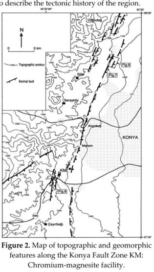
Figure 2. Map of topographic and geomorphic features along the Konya Fault Zone KM:
Chromium-magnesite facility.
Şekil 2. Konya fay zonunun topoğrafik ve
neotektonik haritası. KM: Krom manyezit fabrikası.
The Konya fault zone lies within the low foothills and the Konya depression. The western part of the Konya depression and the surrounding low foothills of the region represent a significant portion of the undeveloped land remaining in Konya city, and as such are on the fringe of rapid urban development. Consequently, the land in this part of the city is receiving very high development pressure from residential interest.
We have conducted detailed studies of the Konya fault zone. The research has been specially concentrated at one specific site, Interstate Road-696 road-cut site southwest of the chromium-magnesite facility (Figure 2). This site is an ideal geologic location to study the Quaternary history of the fault activity due to the young sedimentary units that are well
preserved in the area. The aim of this paper is to locate the trace of the fault zone accurately, establish the style of faulting and determine the activity of the Konya Fault Zone.
GEOLOGICAL SETTING
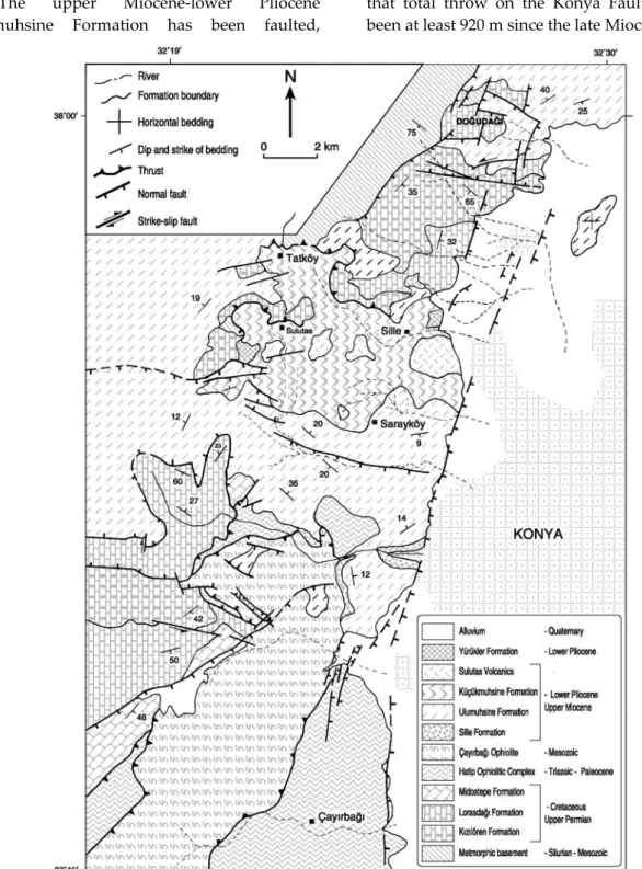
The Konya area is located within the Bolkardağı unit (Özgül, 1976) of Taurides. This geologically complex province is characterized by diverse geologic conditions. Rock units found in and adjacent to the Konya fault zone include undifferentiated metamorphic rock bodies of Silurian-Mesozoic age, the upper Permian Kızılören Formation, the upper Triassic-lower Cretaceous Lorasdağı Formation, the Triassic (?)-Paleocene Hatip Ophiolitic Complex, the Mesozoic Cayırbağı Ophiolite, the upper Miocene-lower Pliocene Sille, Ulumuhsine, and Küçükmuhsine Formations and Sulutas Volcanics, the lower Pliocene Yürükler Formation, as well as the Quaternary older and younger alluvium (Figure 3). The Silurian-Mesozoic low grade metamorphic rocks are exposed northwest of the study area and composed of metacarbonates, flyschoid metaclastics, and metaclastic-metacarbonate alternation. The upper Permian Kızılören Formation (Göğer and Kıral, 1969) is exposed west and northwest of the fault zone. It consists of gray to black, generally massif, brecciodal, in places thinly to moderately bedded, laminated and bituminous limestone. The Kızılören Formation is conformably overlain by the Lorasdağı Formation (Özcan et al. 1988). The formation is composed of gray recrystallized limestone, dolomitized limestone and dolomite interbedded with chert. These formations are tectonically overlain by the Hatip Ophiolotic Complex (Özcan et al. 1988) occurring on the southwestern terminus of the fault zone. It is made up of radiolarite, serpentinite, harzburgite, gabbro and diabase with limestone blocks. The Çayırbağı Ophiolite obducted over the Hatip Ophiolitic Complex during Maastrichtian-lower Paleocene (Özcan et al. 1988). All these units are unconformably overlain by the upper Miocene-lower Pliocene fluvio-lacustrine, volcanoclastic and volcanic rocks that show vertical and lateral transitions. This sequence underlies much of the
area west of the Konya fault zone. Neogene history of the region begins with the fluvial Sille Formation (Eren, 1993) which consists of alternating beds of reddish-brown and gray conglomerate, sandstone and mudstone. Moderately deformed lacustrine strata, the Ulumuhsine Formation (Eren, 1993) conformably overlies the Sille Formation. It is composed of light gray to green, cream limestone, marl, and mudstone interbedded with lenses of conglomerate, conglomeratic sandstone and sandstone. These grade upward and laterally into the volcanoclastic Küçükmuhsine Formation (Eren, 1993). A sequence of reddish-brown to gray fluviatile conglomerate, conglomeratic mud, conglomeratic-sandy mud and mud referred to Yürükler Formation (Eren, 1993) gradationally overlies the Küçükmuhsine Formation and crops out in several discontinuous exposures in the area. All these units are unconformably overlain by the upper Pliocene-Quaternary alluvial complex and alluvium.
KONYA FAULT ZONE
The Konya fault zone comprises a set of discontinuous northeast-trending fault segments along the mountain range bordering the western margin of the Konya depression. The Konya Fault Zone extends a distance of 65 km from east of Hatunsaray on the south to the eastern end of Doğudağ on the north (Figure 1, 2). A 35 kilometer segment of the fault zone from the east of Çayırbağı to the east of Doğudağ is investigated in this study (Figure 2). The fault zone includes subparallel branching that lie within a nearly linear belt, as much as 5 km in width, and comprises east facing, step-like normal faults. They cut older basement (upper Permian-Mesozoic rock units), the upper Miocene-lower Pliocene formations and Quaternary alluvium. The zone increases both in width and complexity toward the southwest. The fault zone strikes 335°W in the southern terminus to N-S in the central part and bends northward from near the Chromium-magnesite facility to the eastern end of Doğudağ of about 15°E. The northwest trending faults represent the antithetic faults of the main fault. Where
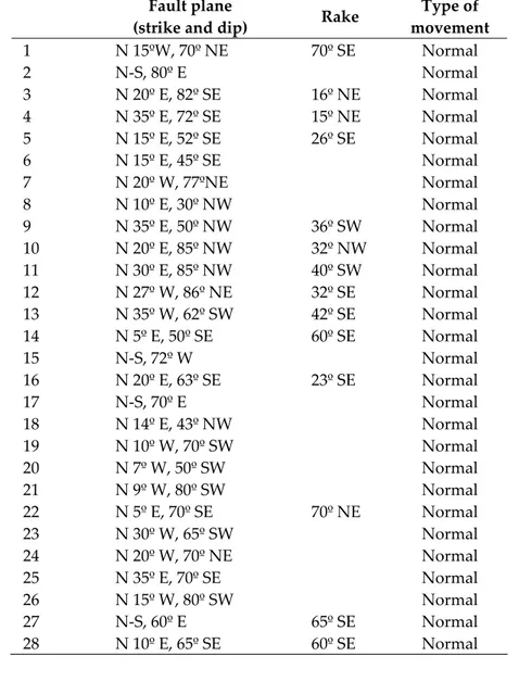
exposed, strands of the fault dip steeply, and the fault is essentially dip-slip fault. It includes well-preserved fault slickensides and slickenside striations (Table 1). Their equal area projections indicate that the Konya Fault Zone is an oblique-slip normal fault zone striking north-northeast and north-northwest and dipping east-northeast and east-southeast at average angle of 58° (Figure 4).
The upper Miocene-lower Pliocene Ulumuhsine Formation has been faulted,
uplifted and tilted as fault terraces lying at different elevations up to 520 m above the present-day elevation (1040 m) of the Konya depression (Figure 2). Boreholes drilled through the Quaternary alluvium (DSİ, 1984) in the hanging wall of the Konya Fault Zone did not encounter the bottom of the same formation at a depth of 400 m below the present-day elevation of the Konya depression. These data indicate that total throw on the Konya Fault Zone has been at least 920 m since the late Miocene.
Figure 3. Geological map of the Konya Fault Zone.
Table 1. Measurement of slickensides and slickenside striations on the Konya fault Zone.
Tablo 1. Konya fay zonundaki fay düzlemlerinin ve kayma çiziklerinin konumları.
Fault plane
(strike and dip) Rake
Type of movement 1 N 15ºW, 70º NE 70º SE Normal 2 N-S, 80º E Normal 3 N 20º E, 82º SE 16º NE Normal 4 N 35º E, 72º SE 15º NE Normal 5 N 15º E, 52º SE 26º SE Normal 6 N 15º E, 45º SE Normal 7 N 20º W, 77ºNE Normal 8 N 10º E, 30º NW Normal 9 N 35º E, 50º NW 36º SW Normal 10 N 20º E, 85º NW 32º NW Normal 11 N 30º E, 85º NW 40º SW Normal 12 N 27º W, 86º NE 32º SE Normal 13 N 35º W, 62º SW 42º SE Normal 14 N 5º E, 50º SE 60º SE Normal 15 N-S, 72º W Normal 16 N 20º E, 63º SE 23º SE Normal 17 N-S, 70º E Normal 18 N 14º E, 43º NW Normal 19 N 10º W, 70º SW Normal 20 N 7º W, 50º SW Normal 21 N 9º W, 80º SW Normal 22 N 5º E, 70º SE 70º NE Normal 23 N 30º W, 65º SW Normal 24 N 20º W, 70º NE Normal 25 N 35º E, 70º SE Normal 26 N 15º W, 80º SW Normal 27 N-S, 60º E 65º SE Normal 28 N 10º E, 65º SE 60º SE Normal
Figure 4. (a) Stereographic equal-area projection of poles to fault planes.
(b) Stereographic plots of the Konya Fault Zone slip data showing the trend and sense of movement.
Şekil 4. (a) Konya fay zonuna ait fay düzlemlerinin kutup noktalarının eşit-alan projeksiyonu.
Geomorphic evidence of young-looking fault features along the fault zone is abundant, and includes scarps of various heights, deflected stream courses, elongate ridges, and lines of springs. However, such evidences are not everywhere equally clear. The location of the fault zone between the Meram and Akyokuş area is uncertain due to the lack of exposures, complexity of visible outcrops, and intense urban development.
Road-cut exposure of Interstate Road 696 at 2 km southwest of Chromium-magnesite facility is the best area for interpreting the nature and Quaternary displacement history of the Konya fault zone (Figure 2). Here low, southeast-facing scarps marking the main and the youngest fault trace indicate dip-slip movement (Figure 5). Reverse faulting of the east side over the west side was also observed. In addition, oblique-slip movement appears to have been prominent along parts of the zone.
Northeastward from Sille Creek to the south of Doğudağ, the fault trace is continuous and delineated principally by low and remarkably straight southeast facing scarps that have various heights (Figure 6). This topography has resulted from normal-slip movement of topographically higher alluvial fan surfaces on the west-northwest side of the fault. Here, relatively low scarps in younger alluvium are moderately youthful in appearance and, are undissected. No evidence of Holocene motion was found along the scarp face; however, the age of the fan and alluvial deposits is uncertain. In a
sand pit area along this segment of the zone, the fault exhibits a general trend ranging from 340°W to 30°E and dips 65°-80° to the east. It is exposed within the unconsolidated to poorly consolidated alluvial materials as normal slip faults (Figure 7). Here, on the main fault any unit having a vertical separation of about 3.5 meters is attributable to one seismic event. This fault also offsets the topsoil horizon, which supports the possibility that the fault is active.
There is no historical record of surface faulting associated with the Konya fault zone, nor is there a record of earthquakes remotely large enough to produce surface faulting. Two earthquakes centering within the area were recorded in 1903 (magnitude 4.4) and 1971 (magnitude 3.7) by the Boğaziçi University, Kandilli Observatory since 1900.
Road-cut Exploratory Site
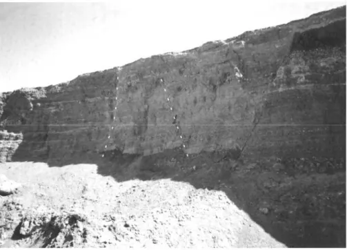
A full analysis of fault history would require trenching and geochronometry. Studying trench exposures across faults has yielded important information on the activity of the faults (Sieh, 1978; Sharp, 1981; Weldon and Sieh, 1985; Rockwell et al. 1986). Trench exposures in Quaternary rock units across active and potentially active faults can provide information to estimate the time and magnitudes of future earthquakes on the fault. As part of subsurface investigation of the Quaternary behavior of the Konya fault zone, a road-cut site astride the trace of the fault zone was studied in detail (Figure 8).
Figure 5. Main fault trace exposed in road-cut (see exploratory road-cut log) offsets all units.
Figure 6. View of the normal fault scarps (dashed lines) affecting Quaternary alluvial fan deposits looking to the northwest from the Konya depression. Segment of the view illustrated in Figure 2.
Şekil 6. Kuvaterner yaşlı alüvyal çökellerde gelişen normal fay dikliği (fotoğraf yeri Şekil 2’de gösterilmiştir).
Figure 7. Normal faults within the Quaternary alluvium in northeast of Sille Creek. Facies differences across the main fault (right side of the photographs) indicate 3.5 meters vertical separation.
Dashed lines indicate minor fault traces in the same deposits (see Figure 2 for location).
Şekil 7. Sille deresinin kuzeydoğusunda Kuvaterner yaşlı alüvyon içinde gelişmiş normal faylar. Ana fay
(fotoğrafın sağında) üzerindeki düşey atım 3.5 metredir (lokasyon için Şekil 2’ye bakınız).
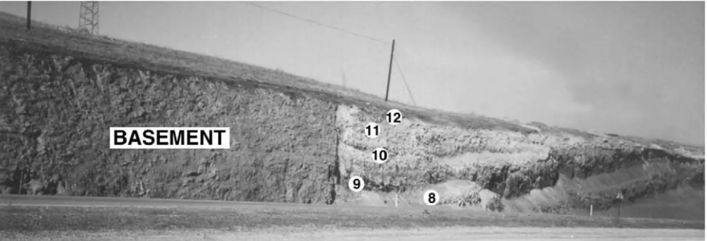
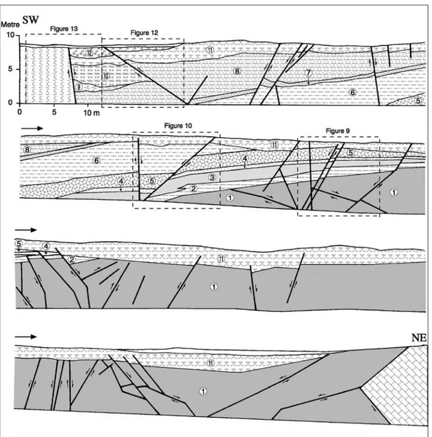
Overlying the faulted bedrock units (Çayırbağı Ophiolite on the southwest side and limestone blocks in Hatip Ophiolitic Complex on the northeast side of the Figure 8) in this road-cut exposure are consolidated to poorly consolidated surficial deposits. These deposits consist of the Sille Formation and Quaternary sediments. These can be divided roughly into 12 units displaying
similar lithologic characteristics. The sedimentary record represents at least three depositional events truncated by erosion (Figure 9). The oldest unit (unit-1, the Upper Miocene-Lower Pliocene Sille Formation) being in the fault contact with the bedrock consists of well bedded to crudely stratified (dipping 55°NE), yellowish-brown to greenish-brown conglomerate, sandstone and mudstone.
Figure 8. Exploratory road-cut log of the Konya fault zone. Surfical deposits are numbered sequentially from oldest to youngest (see Figure 2 for location).
Şekil 8. Yol yarmasında Konya fay zonunun kesit görünümü. Yüzey çökelleri en yaşlı birimden en genç birime
doğru sırası ile numaralandırılmıştır (lokasyon için Şekil 2’ye bakınız).
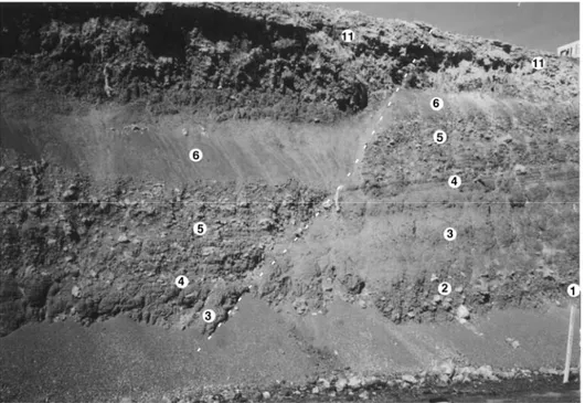
Figure 9. Unconformities (dashed lines) separate overlying unit 11 from underlying units and separate overlying units 2, 3, 4, and 5 from underlying unit 1. (See Figure 8 for location)
Şekil 9. 11 nolu birimi altındaki tüm birimlerden ve 2,3,4 ve 5 nolu birimleri altındaki 1 nolu birimden ayıran
Granules, pebbles and cobbles are usually subrounded to rounded and, are composed of altered serpentinite, listvenite and occasional limestone. Some sequences are gradational upward from coarse-grained deposit to fine-grained sandstone. Individual mudstone layers are especially prominent locally in the middle of the formation. Unit-1 thins southwestward from northeast. This thinning represents a southwestward pinchout of the formation, not merely post-unit-1 erosion (Figure 8). Exposures of this unit display enough information to reveal at least one seismic event that occurred prior to the deposition of unit-2. This will be called event 1. Several small faults related to event 1 occur in unit-1. Differences in facies across the faults and the position of slickenside striations indicate normal slip, oblique slip and reverse slip movement.
The next unit (unit-2) disconformably overlies the unit-1. Unit-2 consists of reddish-brown conglomerate containing a distinctive suite of altered serpentinite clasts. It becomes finer upward. Unit-3 is composed of light brown to red mud. This unit conformably overlies unit-2. Unit-4 consists of light brownish gray to brown sandy conglomerate and fine to medium-grained sand. The unit conformably overlies the below unit and pinches out in both ends. Unit-5 is composed of brown to greenish gray poorly sorted conglomerate. Pebbles and cobbles in conglomerates are usually subangular to subrounded and composed of altered serpentinite. Unit-6 is characteristically composed of reddish-brown to brownish-green mud. In the upper part of this unit fissures were developed. Unit-7 covers fissures that formed after the deposition of unit-6. Grayish-green to yellowish-brown conglomerates of unit-7 fills the fissures. The largest vertical separation attributable to one seismic event occurs after event 1. This is called event 2. Units 3, 4, 5 and 6 have experienced a vertical separation of about 2.3 meters on a fault within the fault zone during event 2, between the deposition of units 2 and 7 (Figure 10). Unit-11, unconformably overlying units 5 and 6, has a vertical separation of about 0.35 meters on the same fault. This implies that the fault started to move after deposition of unit 6 and continued moving
after deposition of unit 11. Fissures in unit-6 opened during event 2 and were later filled. The faults not affecting the upper part of unit 11 represent event 2 faults. Unit-8 is sequence of a heterogeneous mixture of massive, fine to medium grained, reddish-brown sand and mud including scattered serpentinite clasts. Carbonate filled reticular shaped veins developed in this unit. Units 9 and 10 blanket the veins. These veins were probably developed by welling up the groundwater during faulting. Here some of the fault surfaces were also coated with carbonate deposition. Figure 11 shows the carbonate accumulation in the fault plane reaching up to the surface. Unit-9 consists of poorly sorted, unconsolidated conglomerate. Pebbles, cobbles and rare boulders are subangular to subrounded and, are composed mainly of serpentinite and listvenite. Most clasts have diameter smaller than 8 centimeters. This unit thins to northeast. Unit-10 conformably overlies unit-9 and is composed of brown mud with scattered serpentinite clasts. Unit-10 displaced downward on the southwest side of a reverse fault has no equivalent across the fault (Figure 12). This suggests that part of the upthrown block was eroded before the deposition of unit-11. Unit-11 unconformably overlies all the units below and consists of light gray to grayish-brown, thin bedded caliches. Unit-12 forms a soil-like blanket and is composed of reddish-brown, unconsolidated young alluvial materials of gravel, sand and silt. This reverse fault continued moving in the same sense after unit-11 and unit-12 were deposited. The main fault break, about 3 meters southwest of the fault just described, separates bedrock on the west from the surficial deposits on the east (Figure 13). Offsets of these surficial deposits on the hanging wall show significant dip slip on the fault. The faults offsetting upper units 11 and 12 through unit 1 represent event 3. Several minor breaks in unit 11 and 8 do not extend downward into unit 7.
In this study, the timing of these critical events remains to be demonstrated. This requires information about rate of slip and the age of surficial deposits that are presently unanswered.
Figure 10. Normal fault (dashed line) exposed in road-cut (see Figure 8 for location) offsets units below 7 for about 2.3 m during event 2.
Şekil 10. 7 nolu birimin altındaki birimleri ikici sismik evrede yaklaşık 2.3 metre öteleyen normal fay (lokasyon
için Şekil 8’e bakınız).
Figure 11. A normal fault in unit 1 showing carbonate deposition on its surface. The fault reaches up to the surface.
Şekil 11. Yol yarmasında 1 nolu birimin içinde gelişmiş bir normal fay. Fay yüzeye kadar devam etmekte ve fay
Figure 12. A reverse fault (dashed line) cuts late Pleistocene and Holocene surficial deposits (see Figure 8 for location).
Şekil 12. Yol yarmasında Pleyistosen ve Holosen yaşlı birimleri kesen ters fay (lokasyon için Şekil 8’e bakınız).
Figure 13. The main fault trace between basement and late Pleistocene and Holocene surficial deposits. The fault surface were coated with carbonate deposition. It is an event 3 normal fault (see Figure 8 for
location).
Şekil 13. Temel kayaçlar ile Pleyistosen ve Holosen yaşlı birimler arasındaki ana fay. Fay yüzeyi karbonat çökelimi
ile sıvanmıştır. Fay 3. sismik evrede gelişmiş normal bir faydır.
CONCLUSIONS
The Konya fault zone comprises a set of northeast-trending discontinuous fault strands extending from east of Hatunsaray in the south northeastward through the western boundary of Konya depression, a distance of about 65 km. It
is an east-dipping oblique-slip normal fault. Local reverse and strike-slip movements occur along the fault zone. Therefore the dominant Quaternary deformation on the fault zone appears to be tensional. The zone increases both in width and complexity toward the southwest. The study of the road cut exposure in the Konya
fault zone demonstrates recurrent Quaternary faulting. Three seismic events have been identified along the fault zone based on sedimentary deposits and their faulted relationships and faults that are overlain by sediments that deposited after the faults moved but not yet dated. Geologic and geomorphic conditions are peculiarly promising that the Konya fault zone may be classified as active.
ACKNOWLEDGEMENTS
The study of the Konya fault zone was supported by contract 99-033 from Selçuk University Research Fund. Ali Koçyiğit (METU) improved the early version of this paper. We would also like to thank İhsan Seymen (Muğla U.) and Hükmü Orhan (SU) for their critical reviews.
REFERENCES
DSİ, 1984, Konya kenti, içme ve endüstri suyu temini ve dağıtımı şebekesi kati projesi raporu, 250 s. (yayınlanmamış)
Eren, Y., 1993. Konya kuzeybatısında Bozdağlar Masifi’nin otokton ve örtü birimlerinin stratigrafisi. Türkiye Jeoloji Bülteni, c.36, s.7-23.
Göğer, E. ve Kıral, K., 1969. Kızılören dolayının jeolojisi. M.T.A. Derleme rapor no. 5204, Ankara.
Koçyiğit, A., 1984, Güneybatı Türkiye ve yakın dolayında levha içi yeni tektonik gelişim. Türkiye Jeoloji Kurumu Bülteni, c.27, s.1-16.
Koçyiğit, A. and Beyhan, A., 1998. A new intracontinental transcurrent structure: the central Anatolian fault zone, Turkey. Tectonophysics, v. 284, p.317-336.
Koçyiğit, A., Ünay, E., and Saraç, G., 2000, Episodic graben formation and extensional neotectonic regime in west central Anatolia and the Isparta Angle: a case study in the Akşehir-Afyon Graben, Turkey: in
Ministry of Public Works and Improvements, 1986. Earthquake zone map of Turkey.
Özcan., A., Göncüoğlu, M.C., Turan, N., Uysal, Ş., Şentürk, K., and Işık, A., 1988. Late Paleozoic evolution of the Kütahya-Bolkardağı belt, METU Journal of Pure and Appl. Sciences, v.21, 1/3, p.211-220.
Özcan., A., Göncüoğlu, M.C., Turan, N., Şentürk, K., Uysal, Ş., and Işık, A., 1990. Konya-Kadınhanı- Ilgın dolayının temel jeolojisi, M.T.A. Rapor No. 9535, 132p (unpublished).
Özgül, N., 1976. Toros’ların bazı temel jeoloji özellikleri. Türkiye Jeoloji Kurumu Bülteni, 19, s.65-78. Roberts, N., 1983. Age paleoenvironments and climatic significance of late Pleistocene Konya Lake,
Turkey. Quaternary Research, v.19, p.154-171.
Rockwell, T.K., McElwain, R.S., Millman, D.E., and Lamar, D.L., 1986. Recurrent late Holocene faulting on the Glen Ivy North strand of the Elsinore at Glen Ivy Marsh: in, Ehlig, P.L., eds., Neotectonics and faulting in southern California. 82.nd Annual Meeting of the Cordilleran Section of the GSA, Volume and Guidebook, p.167-175.
Sharp, R.V., 1981, Variable rates of late Quaternary strike slip on the San Jacinto fault zone, southern California. Journal of Geophysical Research, v. 86, no. B3, p. 1754-1762.
Sieh, K.E., 1978. Prehistoric large earthquake produced by slip on the San Andreas fault at Pallett Creek, California. Journal of Geophysical Research, v. 83, no. B8, 3907-3939.
Şengör, A.M.C., 1980. Türkiye’nin neotektoniğinin esasları. Türkiye Jeol. Kur. Konferanslar dizisi, 2, 40s. Toprak, V., and Göncüoğlu, M.C., 1993. Tectonic control on the development of the Neogene-Quaternary
Central Anatolian volcanic province, Turkey, Geological Journal, v.28, 357-369.
Weldon, R.J. and Sieh, K.E., 1985. Holocene rate of slip and tentative recurrence interval for large earthquake on the San Andreas fault, Cajon Pass, southern California. Geological Society of America Bulletin, v. 96, no. 6, p.793-812.