ACCURACY INVESTIGATION OF DEM BASED ON GÖKTÜRK-2 STEREO IMAGES
1Omer MUTLUOGLU, 2Merva GUVEN
1 Selcuk University, School of Technical Science, Architecture and Urban Planning, Selcuklu, Konya, Turkey 2 Selcuk University, The Graduate School of Natural and Applied Science, The Degree of Master of Science in
Geomatic Engineering, Selcuklu, Konya, Turkey
1 [email protected]r, 2 [email protected]
(Geliş/Received: 02.12.2016; Kabul/Accepted in Revised Form: 20.02.2017)
ABSTRACT: In December 18, 2012, Gokturk-2 satellite has been launched to the space from the Jiuguan
station in China. The satellite has a pushbroom camera, which can take panchromatic images with 2.5 m resolution and multispectral images with 5 m resolution from 685 km elevation. The requests of Turkish Armed Forces, Turkish government agencies and institutes for satellite images has been satisfied by Gokturk-2 satellite imagery. High Resolution Satellite Images (HRSI) have been extensively used in fields of mapping, intelligence service, exploration, monitoring of environment, agriculture and change tracking; mapping is one of the most widespread application areas of HRSI.
In order to use satellite images like a map, orthoimages are required taking care about image geometry and model configuration. Based on, Ground Control Points (GCP) a Digital Elevation Model was generated for the orthorectification.
In this study, a stereo scene orientation was made using 20*60 km sized stereo pair of Gokturk-2 satellite with various, GCP and Check Point (CP) configurations. Furthermore, the accuracy of the generated Digital Elevation Model(DEM) was analyzed by heights of primary bench marks.
Key Words: GÖKTÜRK-2, High resolution satellite images, Ground control points, Stereo orientation, Digital
elevation model
Stereo Göktürk-2 Görüntülerinde SYM Doğruluğunun Araştırılması
ÖZ: Göktürk-2 uydusu 18 Aralık 2012 tarihinde Çin’in Jiuguan üssünden uzaya fırlatılmıştır. Göktürk-2
uydusu süpürgeç (pushbroom) kameraya sahip olup; 700 km yükseklikte, 2.5m çözünürlüklü (Resolution) pankromatik ve 5 m çözünürlüklü multispektral (kırmızı, mavi, yeşil, yakın kızıl ötesi) bantlarda görüntü sağlayabilmektedir. Göktürk-2 uydusundan elde edilen verilerle, Türk Silahlı Kuvvetleri, Kamu Kurum ve Kuruluşlarının uydu görüntüsü taleplerinin karşılanması amaçlanmıştır. Yüksek Çözünürlüklü Uydu Görüntüleri, haritacılık, istihbarat, keşif, çevrenin izlenmesi, tarım, değişiklik takibi gibi birçok alanda yaygın olarak kullanılmaktadır. En yaygın kullanım alanlarından birisi de haritacılıktır. Uydu görüntülerinin harita gibi kullanılabilmeleri için geometrik bozuklukların giderilmesi yani ortorektifiye (orthorectifiye) edilmeleri gerekir. Ortorektifikasyon işlemi için yer control noktalarına bağlı olarak sayısal yükseklik modeli oluşturuldu.
Bu çalışma da, 20*60 km boyutlarında stereo GÖKTÜRK-2 görüntüsünün farklı sayıda kontrol ve denetleme noktası kullanılarak stereo yöneltmesi yapılmıştır. Ayrıca ana nivelman noktalarıyla Sayısal Yükseklik Modelinin (SYM) doğruluğu analiz edilmiştir.
Anahtar Kelimeler: GÖKTÜRK-2, Yüksek çözünürlüklü uydu görüntüleri, Yer kontrol noktaları, Stereo
yöneltme, Saysal yükseklik modeli.
INTRODUCTION
Thanks to improvements in computer and satellite technology, earth observation many satellites recently have been launched for various purposes. The satellite images are used in areas as mapping, monitoring of environment, agriculture, security intelligence and change detection. The generated orthorectified images provide great convenience to users in the selected coordinate systems.
In order to make proper orthorectification of satellite images, Geometrical model, Ground Control Points (GCP) and Digital Elevation Models (DEM) are needed.
Ground Control Points are a basic requirement for the geo-reference. GCPs are points which can be identified both in the field and in the image. Depending on the characteristics of the study area, GCPs are selected by road intersections and significant feature points. The GCP ground coordinates have been determined by various methods.
Detailed information such as importance, size, form, distribution, accuracy and number of GCPs, which are used for orthorectification of satellite images, could be accessed e.g. in Fraser (2002), Dare et al. (2002), Yilmaz et al. (2004), Ke (2006), Poli et al. (2010) and Mutluoglu et al. (2012).
There are some publications Which analyzed Gokturk-2 satellite images. In Kupcu et al (2014), orthorectification of Rasat and Gokturk-2 satellite images is examined. For this purpose, satellite images with different land characteristics have been used the evaluations are based on, various DEMs as SRTM and ASTER, DTED with varying nimber of GCPs.
In Atak et al. (2015), test studies of Gokturk-2 satellite images from different regions are performed. As a result, it is shown that Gokturk-2 images could be used for orthophotos and DEM production. In addition, the study highlights that it is possible to obtain position accuracy below 10 m.
In Teke (2016), it is emphasized that different images levels are necessary to utilize images of ground observation satellites. Furthermore, work flow of image process is presented.
The aim of this study is to investigate geometric accuracy of stereo Gokturk-2 satellite images.
GÖKTÜRK-2
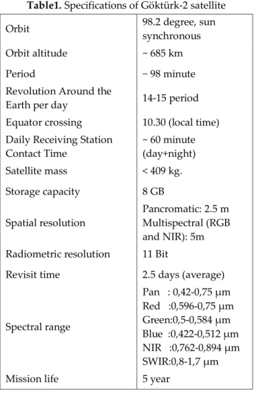
Gokturk-2 is the first ground observation satellite enabling high resolution and uniquely developed in TURKEY. It is designed by a Turkish developer and placed to its orbit in 2012. After RASAT satellite, Gokturk-2 is the second ground observation satellite which is domestically designed and produced by TUBITAK Space Technologies Research Institute and Turkish Aerospace Inc. (Küpcü, 2015). Technical informations of Gokturk-2 are given in Table 1 (URL-1; Çınar, 2014). Earth observation satellites acquire raw imagery. Raw data (Level 0 / L0) are processed for correct geometric and radiometric property. Göktürk-2 Imagery Levels are given in Table 2 (Teke, 2016).
Table1. Specifications of Göktürk-2 satellite
Orbit 98.2 degree, sun
synchronous
Orbit altitude ~ 685 km
Period ~ 98 minute
Revolution Around the
Earth per day 14-15 period
Equator crossing 10.30 (local time) Daily Receiving Station
Contact Time ~ 60 minute (day+night) Satellite mass < 409 kg. Storage capacity 8 GB Spatial resolution Pancromatic: 2.5 m Multispectral (RGB and NIR): 5m Radiometric resolution 11 Bit
Revisit time 2.5 days (average)
Spectral range Pan : 0,42-0,75 µm Red :0,596-0,75 µm Green:0,5-0,584 µm Blue :0,422-0,512 µm NIR :0,762-0,894 µm SWIR:0,8-1,7 µm
Mission life 5 year
Table 2. Göktürk-2 satellite imagery levels
Levels Explanation
L0 Raw data
L1 Radiometric correction applied L1R Band registration completed
L2 Georeferenced images L3 Orthorectified images RGB Red/Green/Blue images Pansharp Pansharpened, enhanced and
USED DATA Test Area
Stereo image taken by Gokturk-2 in 13th May 2015 was used in this study. The test area in Konya, Turkey including settlements, agricultural lands and highlands. The height in the study area varies between 1000m and 1920m. Geographical coordinates of the image taken from study area is specified at table 3. In addition, stereo image is given as Figure 1.
Table 3. Geographic location of test area
Latitude Longitude
Upper left corner 38o 07’45.97’’ 32o 12’08.68’’
lower right corner 37o 37’23.93’’ 32o 36’47.55’’
Figure 1. Göktürk-2 stereo images of test area Office studies
The stereo pare of the study area was taken by Gokturk-2 in 13th May 2015. Images were obtained free of charge from Turkish Air Forces. Studies were carried out by raw images at the LO level. Because images downloaded to ground station are L3-type, they cannot be directly utilized for location based implementations. Therefore, orthorectification process is required.
GCPs, the model and DEM are needed in the orthorectification process. 91 GCPs were determined on the images. The ground coordinates of 61 GCPs were obtained by Google Earth and those of 30 GCPs were obtained by aerial photos with 30 cm resolution. Location accuracy of GCP is less than 2m. Distribution of GCPs on image Figure 2. ERDAS LPS (Leica Photogrammetric Suite) module was used in the evaluation of the images. Since Rational Polynomial Coefficients (RPC) file was not given together with the images, an approximate camera model of LPS was used instead. Thus, generic pushbroom
model was selected as satellite model because the model is able to be designated manually. Then, model was constituted by using parameters from Gokturk-2 satellite Figure 3.
Figure 2. Distribution of GCPs on image
Adjustment was made in the model by using 91 GCPs respectively: whole points as control points, 71 of them as control points and 20 of them as check points, 50 of them as control points and 41 of them as check points, 30 of them as control points and 61 of them as check points, and 25 of them as control points and 66 of them as check points, lastly 10 of them as control points and 81 of them check points. Adjustment results are shown at Table 4.
Figure 3. Göktürk-2 physical camera model
Table 4. Stereo orientation results made by using GCPs in various numbers
as Control and Check Points
Point number Adjustment Results (Pixel) Control Points RMS (m) Check Points RMS (m)
Control Points Check Points rmsx rmsy rmsz rmsx rmsy rmsz
91 0 0.739 4.6 2.6 1.3 0 0 0
71 20 0.634 4.6 2.4 1.3 11.9 11.4 8.9
50 41 0.555 4.8 2.6 1.4 12.1 9.7 7.9
30 61 0.454 5.2 2.6 1.3 11.7 9.6 8.7
10 81 0.765 3.2 3.2 1.8 20.0 9.3 13.2
Horizontal average root mean square errors show an alteration between ±4.5m and ±5.8 m for control points whereas the errors vary between ±15.1 and ±22.1 m for check points.
When Table 4 is examined, it could be said that with a lower number of control points, the root mean square vertical errors for check points raises.
DEM was automatically generated by considering all GCPs control points in Figure 4. The accuracy of DEM was checked by 481 primary bench marks whose heights and coordinates are already known. In the comparison, it is found that the average height error for primary bench marks is RMSZ=±9.3 m. All primary bench marks were separated for location in Highlands and Settlements & Agricultural lands, For highlands is found as RMSZ=±27.1m, while it is RMSZ=±7.4 m for settlements & agricultural lands.
Figure 4. Produced DEM
CONCLUSION
In this study, the stereo image obtained by Gokturk-2 satellite in 13th May 2015 was used. Since images downloaded to ground stations are not L3 type, the images cannot be used directly for location based implementations. Therefore, orthorectification of the images are need.
In the stereo model orientation, control and check points were used in various numbers. The average accuracy of the horizontal components varies between 4.5 m and 5.8 m for control points and 15.1 m and 22.1 m for check points. Then, the accuracy of DEM was tested by primary bench points. The average height error for the study area was calculated as RMSZ=±9.3 m. Separated for the characteristics of the
land, the error was RMSZ=±27.1 m in the mountains area and RMSZ=±7.4 m in the settlements & agricultural lands.
Horizontal and vertical discrepancies are quite larger at check points showing the difference between internal and absolute accuracy. It is considered from that, GCPs can not be obtained with required distribution at mountains area.
Nevertheless, the satellite images could meet needs of many public institutions. As further research, more detailed information about geometric accuracy of Gokturk-2 satellite could be obtained and analyzed by using high resolution GCPs in various land groups (settlements, mountain areas, flatlands etc.).
REFERENCES
Atak, V.O., Erdoğan, M., Yilmaz,A., 2015, “Göktürk-2 Uydu Görüntü Testleri”, Harita Dergisi Ocak 2015, Sayı 153, sayfa 18-33.
Çınar, E., 2014, “GÖKTÜRK-2 Uydu Sisteminin Operasyonel Kabiliyetleri” (Sözlü Sunum), Yer Gözlem Uydu Teknolojileri ve Veri Kıymetlendirme Çalıştayı, Ankara, 19-20 Mart 2014,.
Dare, P., Pendlebury, N., Frase, C., 2002, “Digital Orthomosaics as a Source of Control for Geometrically Correction High Resolution Satellite imagery”, Proceedings of the 23rd Asian Conference on Remote Sensing, Kathmoandu, Nepal, No. 173, 25-29 November 2002.
Fraser, C., 2002, “Prospects for Mapping from High-Resolution Satellite Imagery”, Proceedings of the 23rd Asian Conference on Remote Sensing, Kathmoandu, Nepal, No. 173, November 25-29, 2002.
Ke L. C., 2006, “Orthorectification Accuracies of VHRS Imagery Under the Characteristics of Ground Control Points”, International Symposium on Geoinformatics for Spatial Infractructure Development in Earth and Allied Sciences (GIS-IDEAS) 2006, Ho Chi Minh City, Vietnam, 9-11 November 2006.
Küpcü, R., Teke, M., Çabuk, A., 2014, “Rasat ve Göktürk-2 Görüntülerinin Ortorektifikasyon Başarımına Referans ve Sayısal Yükseklik Modeli Seçiminin Etkisi”, 5. Uzaktan Algılama-CBS Sempozyumu (UZAL-CBS 2014), İstanbul, 14-17 Ekim 2014.
Küpcü., R., 2015, Rasat ve Göktürk-2 Uydu Görüntülerinin Uzaktan Algılama Yazılımları İle Farklı Referans Verileri Kullanarak Geometrik Düzeltme Doğruluğunun Araştırılması, Yüksek Lisans Tezi, Anadolu Üniversitesi, Fen Bilimleri Enstitüsü, Eskişehir.
Mutluoglu, O., Yakar, M., Yılmaz, H.,M., 2012, “The Most Suitable Sizes of Ground Control Points (Gcps) for World View2”, FIG Working Week, Rome, Italy, 6-10 May 2012.
Poli, D., Angiulia, E., Remondinob, F., 2010, “Radiometric and Geometric Evaluation of Worldview-2 Stereo Scenes”, ISPRS Archives – Volume XXXVIII – Part 1, The 2010 Canadian Geomatics Conference and Symposium of Commission I, ISPRS Convergence in Geomatics –Shaping Canada's Competitive Landscape, Calgary, Alberta, Canada, 15-18 June 2010.
Teke, M., 2016, “Satellite Image Processing Workflow for Rasat and Göktürk-2”, Journal of Aeronautics and Space Technologies, January 2016, Vol. 9, No 1 (1-13).
URL-1: GÖKTÜRK-2, 2016, www.tai.com.tr/tr/proje/gokturk-2 (access 18 August 2016).
Yilmaz, H.M., Yakar, M., Mutluoglu, O., Yildiz, F., 2004, “Selection of The Most Suitable Sizes of Ground Control Points in The Satellite Images”, ISPRS Congress Istanbul, 12-13 July 2004.