Series II: Forestry • Wood Industry • Agricultural Food Engineering • Vol. 10 (59) No.1 - 2017
DEVELOPING A HARVESTING PLAN FOR
FORESTED AREAS UNDER THE RISK OF
WINTER STORM DAMAGE
Abdullah E. AKAY
11Đnanç TAŞ
12Abstract:
Timber harvesting activities become more complicated afterwinter storm damages. The risk of storm damage can be estimated based on various factors such as stand structure, topographical characteristics, climatic parameters, and soil type. In this study, a GIS-integrated Analytical Hierarchy Process (AHP) was used to develop a timber harvesting plan based on a previously generated storm damage risk map, terrain conditions, and soil type. The study was implemented in Kütahya region where serious winter storm damages occurred in winter of 2015. The results indicated that the farm tractor logging was suitable for 40.5% of the area, while the chute system was appropriate for 35.5% of the area.
Key words:
Winter storm damage, storm risk map, timber harvesting plan,AHP.
11Department of Forest Engineering, Bursa Technical University, 16300 Yıldırım, Bursa, Turkey.
Correspondence: Abdullah E. AKAY; email: [email protected].
1. Introduction
Abiotic and biotic factors causing damages on forest tress also threat the sustainability of forest resources. The wind damage is one of the most destructive factors among the abiotic factors such as the forest fires, wind, snow, avalanche, and drought [10]. In Turkey, winter storms have resulted in serious damages on forested areas especially in the western regions.
The severity of storm damage generally depends on stand structure, topographical characteristics, climatic parameters, soil type, and soil depth [8], [11] and [15]. In order to minimize the negative effects of winter storms on forest resources, the areas with high risk of storm damage should be mapped based on these factors. GIS
techniques integrated with empirical models are used to produce risk maps of winter storm damages. In particular, GIS-based mathematical models (i.e. regression models, fuzzy logic) can be effectively used in solving such complex problems [5] and [7].
Once the areas characterized by storm risk are mapped, the necessary strategies should be developed and implemented in the field. Then, the silvicultural activities should use suitable logging techniques after the storm damage.
The salvage logging operations after winter storm damage can be very difficult and costly, and they may cause additional impacts on the forest ecosystem. Besides, they are considered as one of the most dangerous forest operations involving serious safety problems. Therefore, a
timber harvesting plan should be well organized by considering economic, ecological, and work safety factors.
The goal of this study was to develop a timber harvesting plan for the areas characterized by a high risk of winter storm damage. A GIS-integrated mathematical model was used, based on a previously generated storm damage risk map. The terrain conditions and soil type were the main factors used in the selection of harvesting systems.
2. Material and Methods 2.1. Study Area
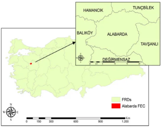
The study was implemented in Alabarda Forest Enterprise Chief (FEC) within the borders of Kütahya Forest Regional Directorate (FRD) (Fig. 1).
Fig. 1. Alabarda FEC in Kütahya In Alabarda FEC, a serious winter storm damage occurred in winter of 2015. The dominant tree species in the area include black pine, Brutian pine, oaks, and other deciduous trees. The average elevation and ground slope are 900 m and 25%, respectively. The data obtained from FEC indicated that about 197,208 m3 of timber are scheduled to be extracted from the area as salvage operations.
2.2. Risk Map of Winter Storm Damage
The risk map of storm damage was developed using a GIS-based mathematical model (Fuzzy Logic) [17].
Tree species, tree age, crown density, site quality, topographical features (elevation, slope, aspect), climatic parameters (wind, precipitation), and soil depth were considered as the risk factors that influence the magnitude of wind damage. The Fuzzy Membership function under the “Spatial Analyst” extension of ArcGIS 10.2 was used to model the risk factors. Finally, the Fuzzy Overlay function using the Gamma defuzzification type was used to generate the risk map of winter storm damage. The study area was divided into four risk zones including high, moderate, low, and very low risk areas.
2.3. Optimum Harvesting Plan
The optimum harvesting plan was developed by the Analytic Hierarchy Process (AHP) approach. AHP is one of the most common multi-criteria decision-support tools used in forestry studies to solve complex decision problems. AHP was first described by Myers and Alpert [12] and modeled by Saaty [14]. The AHP approach analyses a set of evaluation criteria and search for the optimal solution among a set of alternative options.
To find the best solution, AHP method was used to evaluate four alternative harvesting systems implementing cable yarding, chute, skidder, and farm tractor skidding. Then, the harvesting plan was analysed based on three main criteria including the storm damage risk map, terrain conditions (slope), and soil type.
Detailed information about the risk map (10 × 10m) generation can be obtained from Taş (2017) [17]. The ground slope map of the study area was developed using the ArcGIS 10.2, based on a digital elevation model. Then, the slope map (10 × 10m) was
reclassified into five classes according to the IUFRO slope classification for logging operations [9]. In this study, gentle and low slope classes were merged into a single slope class (0-20%) resulting a slope map divided into 4 classes (Table 1).
Table 1
Classes used to build the ground slope map
Slope Classes Ground Slope (%)
Gentle and low 0-20
Medium 21-33
Steep 34-50
Very steep > 50
Cable yarding is commonly used in mountainous regions with steep slope [9]. The chute systems are preferred as an alternative timber extraction equipment for the areas with the slope in range of 20-60% [6]. In recent years, logging companies have effectively used skidders that can operate on slopes up to 40% in Turkey [1] and [2]. At the same time, modified farm tractors are commonly used in timber extraction activities on gentle slopes [13].
The stability of soil is one of the most important limiting factors for ground-based mechanized timber harvesting operations as the impact of harvesting equipment increases on unstable and soft soils. Besides, mobility of the equipment is negatively affected by soft surface soils [3]. In this study, the soil type map (10 × 10m) indicating the stability of the surface soil was generated based on the geological map of the study area. The soil data layer was then reclassified into two classes including stable and unstable soils.
The hierarchy of AHP implemented in this study is shown in Figure 2. The AHP generates a weight for each criterion based on decision maker’s pairwise comparisons. The relative importance between the two criteria is measured according to a numerical scale from 1 to 9 (Table 2). In this study, the relative importance among
sub-criteria was evaluated for each alternative harvesting system. The higher the score, the more important the criterion. The importance of the main criteria was compared using the scale from 1 to 9. Then, a score was assigned to each alternative harvesting system according to the decision maker’s pairwise comparisons. In order to compute the weights for different criteria (or sub-criteria), a pairwise comparison matrix A was generated. Each entry (aji= 1/aij) of the
matrix A represents the importance of the
jth criterion relative to the ith criterion. If aji>1, then the jth criterion is more
important than the ith criterion.
Fig. 2. The hierarchy of AHP method
Scale of relative importance Table 2
Intensity of
Importance Interpretation
1 Equal importance 3 Weak importance of one
over another 5 Essential or strong importance 7 Demonstrated importance 9 Absolute importance 2, 4, 6, 8 Intermediate values between the two adjacent judgments
In the next stage, a normalized pairwise comparison matrix was generated. First, the column vector of B was produced using the Equation 1 [9]:
∑
= = n j ji ji ji a a b 1(1)
where bji is each entry in the column and n
is the number of criteria.
Then, the weighted averages of the criteria (wj) were computed by averaging
the entries on each row, using the Equation 2 [9]: n c w n i ji j
∑
= = 1(2)
The ratio of Consistency Index (CI) and Random Index (RI) were computed to control the consistency of the evaluations made for the pairwise comparison matrices. The small value of this ratio (<0.1) suggests that reliable results can be drawn from the AHP method.After the consistency check, the “Reclassify” tool under the “Spatial Analyst” extension of ArcGIS 10.2 was used to assign weighted average values (wj) to the corresponding criteria. The
process was repeated for three alternative harvesting systems. Then, the “extAhp 2.0” plug-in tool of ArcGIS 10.4.1 was used to combine the weighted averages of the criteria and determine the AHP score for each harvesting system. Finally, the optimum harvesting system with the highest score was determined by a weighted sum of the scores with respect to all the criteria.
3. Results and Discussion 3.1. GIS Data
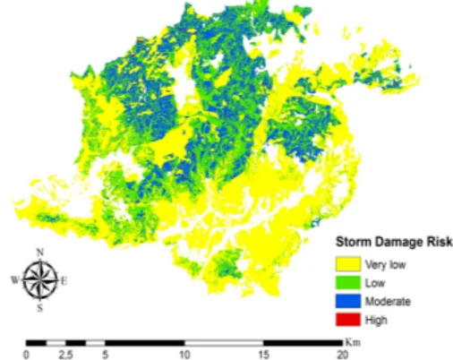
The digital maps were used for three main criteria including storm damage risk, ground slope, and soil type. The risk map of storm damage was developed by using a GIS-integrated Fuzzy Logic model (Table 3).
Table 3
Area distribution on wind storm damage risk
The Risk Level Area (ha)
Very low 10200.43
Low 5465.05
Moderate 3729.63
High 34.32
It was found that 19.2% of the study area was moderately risky, while about 28.1% and 52.5% were low and very low risky zones, respectively. Very little area was classified as highly risky zones in terms of wind damage (Fig. 3).
Fig. 3. The risk map of storm damage The ground slope map was classified into four classes (Table 4). The results indicated that 38% of the study area is located on gentle and low slopes, while 33% is located on medium slopes (Fig. 4). About 22% of the area was classified as high slope terrains and the rest as steep terrain.
The soil type map indicating the stability of the surface soil was generated based on the geological map (Fig. 5).
of the studied area, and it was unstable in the rest.
Table 4
Area distribution on slope classes
Slope Classes Area (ha)
Gentle and low 7309.01
Medium 6462.14
High 4246.39
Steep 1411.89
Fig. 4. Area distribution on slope classes
Fig. 5. Area distribution on soil types
3.2. AHP Results
In the AHP approach, a pairwise comparison matrix was generated to compute the weighted values for the criteria and their sub-criteria. The weighted values of storm damage risk (sub-criteria)
for the alternative harvesting systems are shown in Table 5.
Table 5
The weighted values of storm damage risk
The Risk Level Cable Yarding Chute System Skidder Farm Tractor Very low 0.06 0.58 0.08 0.25 Low 0.06 0.25 0.31 0.58 Moderate 0.35 0.08 0.54 0.08 High 0.53 0.08 0.08 0.08
The cable yarding was a suitable system for the areas with high storm damage risk, while skidders were appropriate for the areas with moderate risk. It was revealed that farm tractors and chute system were preferable for the areas with low and very low risk, respectively.
Table 6 shows the weighted values of slope (sub-criteria) for the alternative harvesting systems. Cable yarding was appropriate for steep terrain, while the chute system was suitable for high slope classes.
Table 6
The weighted values of slope class
Slope Classes Cable Yarding Chute System Skidder Farm Tractor Gentle / low 0.07 0.07 0.13 0.64 Medium 0.07 0.20 0.60 0.21 High 0.21 0.60 0.20 0.07 Steep 0.64 0.13 0.07 0.07
Ground-based logging equipment, namely skidders and farm tractors, were preferable for medium and gentle/low slope areas, respectively. The weighted values of soil type (sub-criteria) for the alternative harvesting systems are shown in Table 7. In this case, ground-based equipment was suitable for stable soil, while cable yarding and chute system were appropriate for unstable soil areas.
Table 7
The weighted values of soil type
Soil Types Cable Yarding Chute System Skidder Farm Tractor Stable 0.42 0.30 0.90 0.80 Unstable 0.58 0.70 0.10 0.20
After the consistency check, weighted average values (wj) were assigned to the
corresponding criteria for each harvesting system. Then, the weighted averages of the criteria were combined for the studied alternatives and the score for each harvesting system was determined by using “extAhp 2.0” tool in ArcGIS 10.2. Table 8 shows the weighted average values of criteria assigned to the alternative harvesting systems.
Table 8
The weighted values of criteria
Criteria Cable Yarding Chute System Skidder Farm Tractor Storm Risk 0.57 0.50 0.50 0.50 Slope 0.36 0.38 0.08 0.13 Soil 0.07 0.13 0.42 0.38 The results indicated that the most effective criterion was the storm damage risk for all of the three alternatives. For cable yarding and chute system, the importance of ground slope was higher than the soil stability, while it was the opposite for the ground-based logging equipment (Fig. 6, Fig. 7, Fig. 8, Fig. 9).
Fig. 6. AHP results for cable system Fig. 7. AHP results for chute system
At the final stage of the solution generation process, the digital data layer indicating the optimum harvesting systems characterized by the highest weighted average was generated with respect to all of the criteria (Fig. 10).
Fig. 10. Map of optimum harvesting
systems
The results indicated that the farm tractor system can be interpreted as the optimum harvesting system for 40.5% of the study area. According to the AHP solution, chute system and skidder were the optimal for 35.5% and 23.4% of the study area, respectively. Cable yarding was optimal for only 0.6% of the area.
The distribution of optimum harvesting systems with respect to the risk of winter storm damage is shown in Table 9. Cable yarding was selected as the optimum system for the areas with high damage risk which are located on steep slopes. Cable yarding preserves forest soil and requires less roads [16]. Besides, on steep terrain where ground-based equipment cannot operate, cable yarding system can be the only solution.
For the moderately risky areas, skidder and chute systems were selected as optimum. On storm damaged stands,
grapple skidders are appropriate especially for extraction of large size timber [16]. Chute systems can be used to slide smaller size timber from uphill stands to landing areas [6].
Table 9
The distribution (%) of harvesting systems with respect to storm damage risk
The Risk Level Cable Yarding Chute System Skidder Farm Tractor Very low 0.00 46.75 18.63 34.62 Low 0.00 20.58 0.00 79.42 Moderate 2.07 26.98 70.95 0.00 High 100.00 0.00 0.00 0.00
On areas with low storm damage risks, mostly farm tractors and then chute system were considered as appropriate. Farm tractors equipped for forestry operations can be used for timber skidding. On steep ground, farm tractors can be used for winching purposes [4]. For about half of the areas with very low risk, chute system was interpreted as optimum, followed by the farm tractor, and skidder.
4. Conclusion
After the winter storm damages, timber harvesting operations must be conducted quickly before the trees deteriorate or lose their economic value. Harvesting in storm damaged areas can be costly and very dangerous. Besides, improper timber harvesting may cause even more impacts on the forest ecosystems. The GIS-integrated AHP method presented in this study can provide decision makers with quick and accurate solutions for harvesting plans in storm damaged areas. Possible future studies may include additional factors such as the stand damage, logging cost, and forest products when attempting to develop a timber harvesting plan.
References
1. Akay A.E., Özkan D., Bilici E., 2016. Assessing Productivity and Work Safety of a Mechanized Logging Operation. In: The International Forestry Symposium (IFS 2016), December 7-11, Kastamonu, Turkey. 2. Akay A.E., Yenilmez N., 2008.
Harvesting machines used in forest operations in North America. Chamber of Forest Engineers. In: Forest Engineering Journal, vol. 45(1-3), pp. 24-28.
3. Akay A.E., Yuksel A., Reis M. et al., 2007. The Impacts of Ground-based Logging Equipment on Forest Soil. In: Polish Journal of Environmental Studies, vol. 16(3), pp. 371-376. 4. Altunel A., Ozer G.C., Torun P., 2016.
Assessment of a Salvage Logging Operation after Winter Storms: A Case Study of Ihsangazi Forest Directorate, Kastamonu-Turkey. In: European Journal of Forest Engineering, vol. 2(1), pp. 41-47.
5. Aydın A., Eker R., 2012. Preparation of Slope Maps Using GIS Based Fuzzy Membership Model and Comparison with Classical Method: A Case Study of Avalanche Risk Assessment. KSU In: Engineering Science Journal, Special Issue, no. 1, pp. 206-212. 6. Çankal H., 2013. Productivity and
environmental evaluation of chute system used in log production Msc. Thesis. KSU, Faculty of Forestry, Kahramanmaraş, Turkey, 39 p.
7. Chang K., 2004. GIS Models and Modelling. Introduction to Geographic Information Systems, Chapter 14. McGraw Hill, New York.
8. Eler Ü., 2002. Importance of site index. Süleyman Demirel University Orman Fakültesi Dergini. Turkish
Journal of Forestry, A, no. 2, pp. 1-10. 9. Gulci N., 2014. Researches on
precision forestry in forest planning. PhD Thesis. KSU, Faculty of Forestry, Kahramanmaraş, Turkey, 264 p. 10. Lorz C., Fürst C., Galic Z. et al., 2010.
GIS-based Probability Assessment of Natural Hazards in Forested Landscapes of Central and South-Eastern Europe. In: Environmental Management, vol. 46(6), pp. 920-930. 11. Moore J.R., 2000. Differences in
maximum resistive bending moments of Pinus radiata trees grown on a range of soil types. In: Forest Ecology and Management, vol. 135, pp. 63-71. 12. Myers J.H., Alpert M.I., 1968.
Determinant Buying Attitudes: Meaning and Measurement. In: Journal of Marketing, vol. 32(4), pp. 13-20. 13. Öztürk T., Akay A.E., 2007.
Modifying Farm Tractors for Forest Harvesting Operations. In: Int Sym Bottlenecks, Solutions, and Priorities in the Context of Functions of Forest Resources. October 17-19, Đstanbul, Turkey.
14. Saaty T.L., 1977. A scaling method for priorities in hierarchical structures. In: Journal of Mathematical Psichology, vol. 15, pp. 234-281.
15. Schmoeckel J., Kottmeler C., 2008. Storm damage in the Black Forest caused by the winter storm “Lothar” – Part 1: Airborne damage assessment. In: Natural Hazards and Earth System Science, vol. 8, pp. 795-803.
16. STODAFOR, 2004. Technical Guide on Harvesting and Conservation of Storm Damaged Timber, 105 p.
17. Taş Đ., 2017. Developing the risk map of winter storm hazard using GIS based Fuzzy Logic method. Msc. Thesis. Bursa Technical University, Faculty of Forestry, Bursa, 79 p.