• Sonuç bulunamadı

Earthquake Induced Sedimentary Structures (Seismites): Geoconservation and Promotion as Geological Heritage (Lake Van-Turkey)

N/A
N/A
Protected

Academic year: 2021

Share "Earthquake Induced Sedimentary Structures (Seismites): Geoconservation and Promotion as Geological Heritage (Lake Van-Turkey)"

Copied!
7
0
0

Yükleniyor.... (view fulltext now)

Tam metin

(1)

ORIGINAL ARTICLE

Earthquake Induced Sedimentary Structures (Seismites):

Geoconservation and Promotion as Geological Heritage

(Lake Van-Turkey)

Serkan Üner1&Merve Gizem Alırız1&Erman Özsayın2&Azad Sağlam Selçuk1&

Mustafa Karabıyıkoğlu3

Received: 15 October 2015 / Accepted: 5 May 2016 / Published online: 12 May 2016 # The European Association for Conservation of the Geological Heritage 2016 Abstract The Lake Van Basin, located at the collision zone of the Eurasian and Arabian plates, has great potential in terms of geological heritage. The world’s largest soda lake which gives its name to the basin contains magnificent geological struc-tures. Lacustrine deposits of the lake represent important clues about seismic activity during the Late Quaternary in addition to its sedimentological and paleontological background. Seismites—deformational structures which are formed during earthquakes in unconsolidated sediments—are very rare geo-logic phenomena. These structures, formed by earthquakes of magnitude≥5 under suitable conditions, provide valuable in-formation about the responsible faults and their seismic repe-tition frequency for the region. Today, rising awareness of geological heritage is a glimmer of hope for the protection and preservation of these rare structures in the Lake Van Basin for the generations to come. Conservation of these structures will also help the protection of other naturally, his-torically, and culturally significant geological beauties. The responsibility for the promotion and conservation of these

geological heritages should be a mission not only for the hosting country but also for the entire geological community. Keywords Geological heritage . Seismites . Late Quaternary . Lake Van . Turkey

Introduction

Geological structures supply information about the past which cannot be obtained from other sources. This information con-sists of several events including climatic changes, timing of volcanisms, earthquake repeating periods, timing of glacia-tions, and sea-level fluctuations. These structures are widely spread on earth while some of them are rare or unique, and are a part of the geological heritage (ProGEO2011).

The East Anatolian Plateau (Turkey), located at the collision zone of the Arabian and Eurasian plates, is a natural laboratory where several lithologies are juxtaposed. Metamorphic rocks, shallow and deep marine sediments, active volcanoes (Nemrut, Süphan, Tendürek, and Ağrı), and the Lake Van—the biggest soda lake in the world—constitute the significant and spectac-ular geological beauties of the plateau (Fig.1).

The ancient deposits of the Lake Van keep records of the geological events since its formation. These deposits magnif-icently represent tectonism related to major structural ele-ments such as faults and folds. The less-known deformational structures—seismites—constitute another group which are formed in unconsolidated sediments due to the seismicity of the area. Seismites, observed in the ancient deposits of the Lake Van, are very rare, significant, and spectacular structures that should be preserved and promoted as geological heritage. * Serkan Üner

suner@yyu.edu.tr

1

Department of Geological Engineering, Yüzüncü Yıl University, 65080 Van, Turkey

2

Department of Geological Engineering, Hacettepe University, 06800 Ankara, Turkey

3

Department of Geography, Ardahan University, 75000 Ardahan, Turkey

(2)

Therefore, this study aims to introduce several types of seismites observed in the Lake Van deposits and to expose their potential in terms of protection, education, and geotourism.

Geological Framework

The East Anatolian Plateau is a high plateau which emerged from the collision between the Arabian and Eurasian plates approximately 13 Ma ago (Şengör and Yılmaz1981). This region contains Lake Van largest soda lake of the World (607 km3 volume, 3570 km2 surface area, and 451 m maximum depth; Kempe et al.1978) which formed 600 ka ago (Stockhecke et al.2014).

The Lake Van is situated on a basement composed of Palaeozoic metamorphic rocks, Upper Cretaceous ophiolites, and Miocene turbidites (Acarlar et al.1991). The deposits of

the Lake Van interlace with the pyroclastics of the Nemrut and Süphan volcanoes which were active in Late Quaternary. These deposits are mostly observed at the northern, eastern, and rarely at the southern parts of the lake (Fig.2). These deposits repre-sent the sedimentation processes occurred at higher water levels of the lake. Shallow and deep lacustrine and coastal facies are common in the area due to the lake water level oscillations during time (Fig.3).

The Lake Van basin, located to the north of the collision zone, is situated at one of the most seismically active regions of the world. The tectonism is represented mostly by thrust and strike-slip faulting in the region (Şengör and Kidd 1979; Özkaymak et al. 2011; Koçyiğit2013) (Fig. 2). Most recent and devastating examples are the Çaldıran (24 November 1976 - Ms= 7.2) and Van-Tabanlı earthquakes (23 October 2011 - Ms= 7.2). Besides, numerous earthquakes having mag-nitude≥5 have been recorded during historical and instrumental periods for the Lake Van basin (Ambraseys and Finkel1995). Fig. 1 Digital elevation model showing the Lake Van and the surrounding region

(3)

Seismites

The deformational structures observed in the unconsolidated sediments occur due to liquefaction or fluidization of

water-saturated, non-cohesive, and unconsolidated sediments during or after deposition (Lowe1975; Owen1996). The reasons of the formation of these structures are overpressure (Lowe and LoPiccolo1974), storm-originated waves (Molina et al.1998; Fig. 2 Map showing the distribution of the lacustrine deposits and the sites of seismites (modified from Acarlar et al.1991; Üner2014)

Fig. 3 Fossils and the sedimentary structures from ancient lacustrine deposits of Lake Van, a leaf fossil, b pelecipoda and gastropoda fossils, c wave ripples, and d trace fossils

(4)

Alfaro et al.2002), and earthquakes (Seilacher1969; Lowe 1975; Sims1975; Rossetti1999; Vanneste et al.1999; Jones and Omoto 2000; Rodriguez-Pascua et al.2000; Bowman et al.2004; Van Loon2014).

All structures formed by the earthquakes in unconsol-idated sediments are known as Bseismites^ (Seilacher 1969). Some characteristic features should be determined in order to identify a structure as seismite. These are (1) the grain size of the sediment should be suitable for liq-uefaction (sand or silt size); (2) deformational structures should be observed between different undeformed parallel layers; (3) structures should represent similar characteris-tics with the formerly published structures in terms of shape, size, and sedimentological properties; (4) the area where these structures are found should have seismic po-tential to generate earthquakes with magnitudes ≥5; and (5) there should be no evidence of other triggering mech-anisms such as overpressure or storm-originated waves (Sims1975; Obermeier1998; Bowman et al.2004). Lake Van Basin Seismites

Several deformational structures have been identified in different stratigraphic levels of the ancient deposits of the Lake Van. Taking into account the characteristics men-tioned above and regional seismicity, it can be inferred that most of these deformational structures were generat-ed by the seismicity and should be namgenerat-ed as seismites. These structures, observed in different levels of the hori-zontal-bedded, sandy, and silty deposits, are classified as dish and pillar structures, convolute structures, flame structures, and ball and pillow structures according to their shapes, dimensions, and sedimentological properties (Fig.4) (Üner 2014).

These structures which can be formed within a maxi-mum radius of 100 km far from the epicentre of the earth-quake (independent from the type of the fault) (Galli and Meloni1993; Moretti et al. 1995) are found in 12 differ-ent locations in the Lake Van basin. Considering the lo-cations and propagations of the seismites (Fig.2), it can be declared that several active faults played a role in the generation of these structures rather than a single one (Üner et al.2010; Üner2014).

Promotion and Geoconservation of Seismites

The East Anatolia region is located in a lesser developed or developing part of Turkey. Unfortunately, the growth processes including transportation and industry often lead to the destruction of nature and natural beauties in the region. These rare geological structures—diversities of the Earth displaying heritage value—can be protected

and promoted if sufficient awareness is introduced to lo-cal population which can only be created by earth scien-tists. Considering the Lake Van seismites as geological heritage is a necessity not only as scientific objects, but also as important educational resources and/or attractive geotourism products.

Promotion

The promotional activity is composed of two main subdivi-sions: scientific promotion and touristic promotion. For the scientific promotion, we can put forth the formation and evo-lution of the seismites; the importance of these structures for the region and correlate with others observed at different re-gions of the world. We can also be responsible from the inter-active accessibility of that information. Billboards about the seismites can be prepared at each geosite containing informa-tion about related structures with links to websites. These boards can also contain QR barcode for smart phones, or tablets, directing to the websites. The websites can be orga-nized in multiple languages with photos, animations, and text for the visitors.

A second-order responsibility should be shared by the local administrations (municipalities) and national authority (Tourism Ministry). Beside their financial support, severe measures should be taken in terms of landscape architecture, transportation, and protection by them. Consequently, these efforts will contribute to tourism and national/regional economy.

Geoconservation

The most important subject in geoheritage is the conservation of these structures (Burek2012). Enabling the local public to contribute to promotional activities, and giving them opportu-nity to make profit from these natural beauties (e.g., transpor-tation, security, and accommodation) will increase awareness and help people protect these beautiful examples such as those found in Cappadocia fairy chimneys (Central Anatolia) and Pamukkale travertines (Western Anatolia) which are in the world heritage list of UNESCO.

Another significant topic is to increase the awareness of these structures in terms of geological education and to inject natural affection, in a similar way to the fieldwork carried out in Italy and Greece with children aged between 13 and 17 (Fermeli et al.2015). In this way, conservation consciousness will be conducted to next generations.

Other Natural and Historical Beauties

As Lake Van constitutes the largest water body in the East Anatolia, many different cultures have lived in the region

(5)

during historical times. Settlement in the region initiated with Urartians (860 B.C.) and continued with the Great Seljuk Empire (1071 A.C.). Several historical and religious architec-tural remnants are located especially around city of Van. The Van Castle (Urartian) and Akdamar Island Church (Armenian) are well-known examples (Fig.5).

The Lake Van basin offers many natural beauties to the visitors beside the seismites mentioned in this study. The Nemrut volcano and its caldera (Fig.6a) and Muradiye water-fall eroding the volcanic rocks (Fig.6b) are some of the mag-nificent products of the Quaternary volcanism in the region. Additionally, a local fish known as the Pearl Mullet (Chalcalburnus tarichi), from the Cprinidae family, that lives in the soda (basic) water of the Lake Van, migrates upward

along the rivers (Fig.6c). This natural event is promoted and celebrated with festivals every April–June.

Conclusions

Besides its rareness, values of the structures classified as geo-logical heritage can be measured for their scientific, educa-tional, touristic, and regional economical contributions. The Lake Van basin is such an area with its spectacular geological, cultural, and historical beauties. The conservation and promo-tion of these beauties, only known to date by local inhabitants, have a key importance for the region. The first step for their protection is an appreciation of these rare structures. It will be Fig. 4 Types of seismites from lacustrine deposits of Lake Van; a dish and pillar structures, b simple convolutions, c complex convolutions, d flame structures, e ball structures. Seismites observed in f different stratigraphic levels and g different size in lacustrine deposits

(6)

easier to conserve such structures when their importance is understood by both domestic and international visitors.

Although Lake Van and its surroundings are protected through the convention for wetland protection (RAMSAR),

most of the ancient deposits including seismites are not located in the boundaries of the protected area. This study, therefore, is intended to raise the profile of these important structures, in terms of protection, promotion, and safeguard for posterity. Fig. 5 Historical places around

the study area, a Van Castle and b Church of Akdamar Island

Fig. 6 Natural beauties from study area, a Nemrut Volcano and their caldera, b Muradiye Waterfall, and c upward migration of the Pearl Mullet along the rivers

(7)

Acknowledgments This study is financially supported by Scientific and Technological Research Council of Turkey (TUBITAK) Scientific Research Project (114Y216). The authors wish to express their thanks to the editor and anonymous reviewers for their valuable and constructive comments and suggestions. We are also grateful to Linda Worley Yılmaz for the English language editing of the final text.

References

Acarlar M, Bilgin AZ, Elibol E, Erkan T, Gedikİ, Güner E, Hakyemez Y, Şen AM, Uğuz MF, Umut M (1991) Van Gölü doğusu ve kuzeyinin jeolojisi [Geology of the eastern and northern part of Lake Van]. The Mineral Research and Exploration Institute of Turkey (MTA) report Nr: 9469. 94 pp

Alfaro P, Delgado J, Estevez A, Molina JM, Moretti M, Soria JM (2002) Liquefaction and fluidization structures in Messinian storm deposits (Bajo Segura Basin, Betic Cordillera, southern Spain). Int J Earth Sci 91:505–513

Ambraseys NN, Finkel CF (1995) The seismicity of Turkey and adjacent areas: a historical review, 1500–1800. Eren Publishers, İstanbul Bowman D, Korjenkov A, Porat N (2004) Late-Pleistocene seismites

from Lake Issyk-Kul, The Tien Shan range, Kyrghyztan. Sediment Geol 163:211–228

Burek C (2012) The role of LGAPs (Local Geodiversity Action Plans) and Welsh RIGS as local drivers for geoconservation within geotourism in Wales. Geoheritage 4(1–2):45–63

Fermeli G, Hevia GM, Koutsouveli A, Dermitzakis M, Calonge A, Steininger F, D’Arpa C, Di Patti C (2015) Geoscience teaching and student interest in secondary schools-preliminary results from an interest research in Greece, Spain and Italy. Geoheritage 7:13–24 Galli P, Meloni F (1993) Nuovo catalogo dei processi di liquefazione avvenuti

in occasione dei terremoti storici in Italia. Quaternario 6:271–292 Jones AP, Omoto K (2000) Towards establishing criteria for identifying

trig-ger mechanisms for soft-sediment deformation: a case study of Late Pleistocene lacustrine sands and clays, Onikobe and Nakayamadaira Basins, northeastern Japan. Sedimentology 47:1211–1226

Kempe S, Khoo F, Gürleyik Y (1978) Hydrography of Lake Van and its drainage area. In: Degens ET, Kurtman F (eds) The geology of Lake Van. The Mineral Research and Exploration Institute of Turkey (MTA) Publication 169, pp. 30–44

Koçyiğit A (2013) New field and seismic data about the intraplate strike-slip deformation in Van region, East Anatolian plateau, E. Turkey. J Asian Earth Sci 62:586–605

Lowe DR (1975) Water escape structures in coarse-grained sediments. Sedimentology 22:157–204

Lowe DR, LoPiccolo RD (1974) The characteristics and origins of dish and pillar structures. J Sediment Petrol 44:484–501

Molina JM, Alfaro P, Moretti M, Soria JM (1998) Soft-sediment deforma-tion structures induced by cyclic stress of storm waves in tempestites (Miocene, Guadalquivir basin, Spain). Terra Nov. 10:145–150

Moretti M, Pieri P, Tropeano M, Walsh N (1995) Tyrrhenian seismites in Bari area (Murge–Apulian foreland). Atti dei Convegni Licenci 122: 211–216

Obermeier SF (1998) Liquefaction evidence for strong earthquakes of Holocene and latest Pleistocene ages in the states of Indiana and Illinois, USA. Eng Geol 50:227–254

Owen G (1996) Experimental soft-sediment deformation: structures formed by the liquefaction of unconsolidated sands and some an-cient examples. Sedimentology 43:279–293

Özkaymak Ç, Sözbilir H, Bozkurt E, Dirik K, Topal T, Alan H, Çağlan D (2011) 23 Ekim 2011 Tabanlı-Van Depreminin Sismik Jeomorfolojisi ve Doğu Anadolu’daki Aktif Tektonik Yapılarla İlişkisi. [Seismic geomorphology of the October 23, 2011 Tabanlı-Van earthquake and its relation to active tectonics of East Anatolia]. J Geol Eng 35(2):175–199

ProGEO (2011) Conserving our shared geoheritage—a protocol on geoconservation principles, sustainable site use, management, field-work, fossil and mineral collecting. http://www.progeo.se/progeo-protocol-definitions-20110915.pdf(13 October 2015)

Rodriguez-Pascua MA, Calvo JP, De Vicente G, Gómez-Gras D (2000) Soft sediment deformation structures interpreted as seismites in la-custrine sediments of the Prebetic Zone, SE Spain, and their poten-tial use as indicators of earthquake magnitudes during the Late Miocene. Sediment Geol 135:117–135

Rossetti DF (1999) Soft-sediment deformational structures in late Albian to Cenomanian deposits, Sao Luis Basin, northern Brazil: evidences for paleoseismicity. Sedimentology 46:1065–1081

Seilacher A (1969) Fault-graded beds interpreted as seismites. Sedimentology 13:155–159

Şengör AMC, Kidd WSF (1979) Post-collisional tectonics of the Turkish-Iranian plateau and a comparison with Tibet. Tectonophysics 55: 361–376

Şengör AMC, Yılmaz Y (1981) Tethyan evolution of Turkey: a plate tectonic approach. Tectonophysics 75:181–241

Sims JD (1975) Determining earthquake recurrence intervals from defor-mational structures in young lacustrine sediments. Tectonophysics 29:141–152

Stockhecke M, Kwiecien O, Vigliotti L, Anselmetti FS, Beer J, Çağatay MN, Channell JET, Kipfer R, Lachner J, Litt T, Pickarski N, Sturm M (2014) Chronostratigraphy of the 600,000 year old continental record of Lake Van (Turkey). Quat Sci Rev 104:8–17

Üner S (2014) Seismogenic structures in Quaternary lacustrine deposits of Lake Van (eastern Turkey). GeolSogos 20(2):79–87

Üner S, Yeşilova Ç, Yakupoğlu T, Üner T (2010) Pekişmemiş sedimanlarda depremlerle oluşan deformasyon yapıları (sismitler): Van Gölü Havzası, Doğu Anadolu. [Earthquake-induced soft-sediment deformation structures (seismites): Van Gölü Basin, east-ern Anatolia]. Bull Earth Sci 31:53–66

Van Loon AJ (2014) The life cycle of seismite research. Geologos 20(2): 61–66

Vanneste K, Meghraoui M, Camelbeeck T (1999) Late Quaternary earthquake-related soft-sediment deformation along the Belgian portion of the Feldbiss Fault, Lower Rhine Graben system. Tectonophysics 309:57–79

Şekil

Fig. 3 Fossils and the sedimentary structures from ancient lacustrine deposits of Lake Van, a leaf fossil, b pelecipoda and gastropoda fossils, c wave ripples, and d trace fossils
Fig. 6 Natural beauties from study area, a Nemrut Volcano and their caldera, b Muradiye Waterfall, and c upward migration of the Pearl Mullet along the rivers

Referanslar

Benzer Belgeler

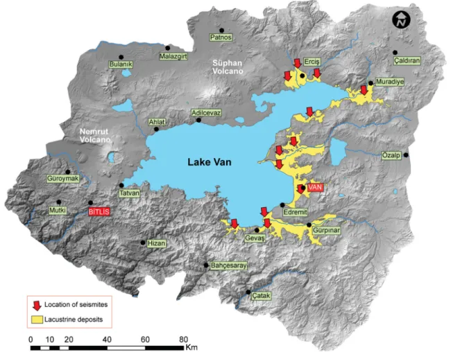
Bu çalışmada, Van Gölü Havzası’nda, gölsel çökellerde gözlenen defor- masyon yapıları; büklümlü yapılar, su kaçış ya- pıları ve yük yapıları olarak üç gruba

Acısu Deresi ile Akdeniz sahili arasında kalan kara parçasının kıyı kullanımı incelemiş Kıyı Kenar Çizgisinin ve Akarsu Kıyı Kenar Çizgisinin özel konumu

Bir süredir, kaldırıldığı Çatalca Devlet Hastanesi’nde tedavi gören Raif Ertem, dün akşam saat 18.00’de bütün müdahale­ lere karşın kurtanlamadı..

The mean of ICP between two measurements was significantly correlated (r = .93, p < .001) at head 0 degree position, and the bias (mean difference) showed significant differences

The antibacterial activity of royal jelly, rape honey, individually and in combination has been reported against resistant strain of E.. Antibiotic-resistant bacteria

yaşları toplamı 73 olduğuna göre, Mert bugün kaç S9.. Başta verilen sözcüğün eş anlamlısını boyayalım. " Akışkan özellik taşıyan, belli bir şekli olmayan.

"ıfiielsefe denilen insan etkinliği çok önemli ve ciddi diyebileceğimiz konular l,JIııakkında açık bir biçimde düşünme eyleminin önemli oldugu

Retrospektif olarak yapılan bu çalışmada hastaların dosyalarındaki bilgilerden yararlanılarak hastaların cinsiyet dağılımı, hastalığın başlangıç yaşı ve