The Roman Frontier from Wallsend to Rudchester Burn Reviewed
Julian Bennett
ED IT O R ’S NOTE
This paper reports on work carried out 10 years ago, but circumstances have prevented the author fro m revising the report beyond 1994. The importance o f the work, however,* justifies its publication in unrevised form .
INTRODUCTION
I
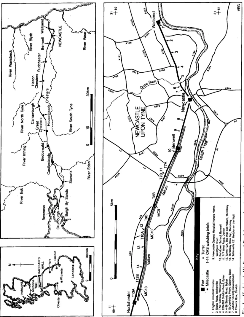
T IS some sixty-five years since Messrs Spain, Simpson and Bosanquet (1930), on behalf of the North of England Excavation Committee, published their seminal paper on the most east erly sector of Hadrian's Wall. Some of the ques tions raised by them have been since been resolved, but others remain germane, princi pally those relating to the nature of the Roman frontier in the sector between Wallsend and Newcastle (fig. 1).As has recently been noted in these tracts (and elsewhere) much of our evidence for the Roman Wall on Tyneside, especially the posi tions of the interval structures, is most unsatis factory, underlining “the importance of seizing ■ any opportunity to examine the Wall” in this area (Bidwell and Watson 1989, 26), an unstated corollary being the necessity to have the information published and available in the public domain. At the same time, it should be noted that a record of the negative evidence for the frontier is, at least in the urban environ ments pertaining in Tyneside, and given our ignorance of the local topography in the Roman period, often as illuminating as the positive.
The principal purpose of this paper is to report the results of salvage and rescue exca vations undertaken by the then Central Exca vation Unit, now Central Archaeology Service
(hereafter CAS), English Heritage, along the line of the Wall in the W allsend-Rudchester sector between 1977-1984. A bald series of summaries of small excavations by itself, how ever, is hardly appealing to even the most recondite of Limesforscher. Thus, the opportu nity is also taken to put these results into their wider context, using some of the material pre sented by the author in his unpublished PhD thesis submitted to the University of Newcas tle upon Tyne (Bennett 1990). N o apology is required and the justification is two-fold: partly because certain of the hypotheses therein were in some cases derived from the results of the Unit's unpublished work on the Wall; and partly because many of them have since been confirmed by more recent work, even if others remain to be tested. Thus a sec ondary object of this report is to review the evidence in the Wallsend-Rudchester sector as it relates to four specific fields, namely the nature of any immediate pre-Roman activity; the character and chronology of the frontier itself; the spacing of the interval structures along this length of the frontier; and the prob able relative date, and the purpose and func tion of the Vallum. It is not for one moment thought that the publication of “yet another report on Hadrian’s Wall” will resolve these matters. Likewise, it is accepted that certain of the observations advanced will not be wel comed in certain quarters, not least because as John Locke divined, “New opinions are always suspected, and usually opposed, without any other reason but because they are not already common.” That said, it is hoped that at the very least, the shades of Messrs Spain, Simp son and Bosanquet will welcome the diversion and any controversy this paper causes!
F ig . 1 H a d ri a n ’s W al l ea st of R u d ch es te r, sh ow in g th e lo ca ti o n s of th e si te s di sc u ss ed in th is re p o rt . P ri n ci p a l m od er n ro a d s in d ic a te d , as ar e th e p o si ti o n s of pr ov en in te rv a l st ru ct u re s al on g th e cu rt ai n w a ll
PRE-RO M AN ACTIVITY
EXCAVATION AN D SURVEY
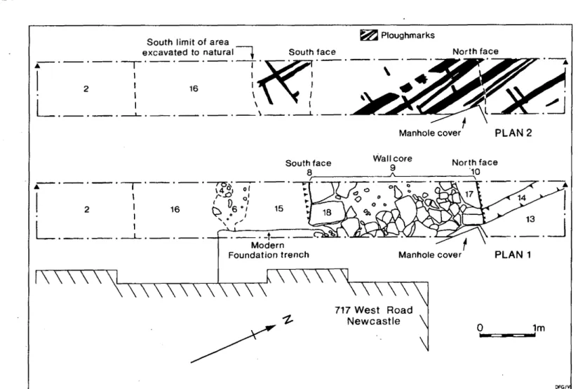
It was George Jobey’s recognition of sealed ard-marks beneath the Military Way at Stotts House Tumulus in 1964 (Jobey 1965, 80) which alerted local and national archaeologists to the potential of recovering evidence for earlier agriculture on the northern boulder clays. Since then, comparable evidence for pre- Roman ploughing has been revealed at a num ber of other sites in the Wallsend-Rudchester sector. One of these was at Throckley, where the writer’s excavation of TlOa, reported on in an earlier volume of these tracts (Bennett 1983, 55-8), revealed the traces of at least six individual phases of cross-ploughing in the period preceding construction of the turret. A second was 717 West Road, Denton (CAS Site 196, N Z 1998 6548, fig. 1, site 11), some 200 yards east of T7b, where the foundation trench for the Wall was cut through a loamy soil horizon, itself sealed on either side of the trench by loamy clay spreads. The fine nature of the pre-Wall soil immediately suggested it might represent a sealed ploughsoil, an observation confirmed after its removal, when the natural boulder clay subsoil was revealed to be scored with a series of inter secting ard-marks (figs 2 and 3).
DISCUSSION
Evidence for pre-Roman ploughing has now been found from eight sites in the W allsend- Rudchester sector: at Wallsend itself (two phases); Walker; Newcastle fort and the West- gate Road Milecastle; West Denton; Denton West Road; Throckley; and Rudchester.2 There are a further three locations where the published accounts of earlier excavations detail what seems to be a cultivated soil hori zon, namely Denton Burn, Walbottle Dene and Great Hill (Brewis 1927). Outside the W allsend-Rudchester sector, similar activity has been identified at another seven locations: Halton Chesters; Corbridge; Wallhouses; Car- rawburgh; Dimisdale; Tarraby Lane (where one phase is dated to c.130 B .C .); and Carlisle.3
It is often assumed that all these separate episodes are coeval, although aside from Tarraby, where the activity has been dated by independent means, the Roman structures sealing and preserving the ard-marks provide little more than a broad terminus ante quem. Leaving aside the possibility that some of these marks might actually be substantially pre-Roman in date, a likely context for them is the known amelioration in the overall climate of the north-east which began c.700/600 b.c.
and climaxed c.a.d. 100, resulting in less rain
fall and an improvement in the mean tempera ture, producing a climate generally similar to that experienced today, although with less severe winters (Lamb 1981, 55; Turner 1981). Such an inference is supported by palynologi- cal evidence for a major increase in woodland clearance in the region at about the same time, indicated by a rapid decline in arboreal pollen and a corresponding increase in the pollens of pastoral and, to a lesser extent, arable species. This clearance phase commenced c. I O Ob.c. in
southern County Durham and Weardale, but did not reach the Tyne valley for another cen tury or so, which might suggest that the north eastern region was being progressively cleared and exploited as and when conditions permit ted (Wilson 1983, 45; Turner 1983, 10). Some wooded areas certainly survived this phase, however,4 and the presence of pig bones at many pre-Roman and Roman sites in the north-east might suggest pannage within forested areas. Moreover, managed woodland was in any case needed for fuel and building materials, and thus substantial areas of wood land probably existed alongside extensive areas of clearance.
Regrettably, unfavourable soil conditions, and a consequent lack of pollen residues, have limited successful palaeobotanical research at most of the locations where pre-Roman ploughing is known, and it is not at all certain what the pre-Roman ground cover was in the Wallsend-Rudchester sector. Thus, while it is usual to interpret the evidence for clearance and cultivation as indicating the dominance of a primarily agrarian regime, it need not be the case at all the sites under review. The
ard-Ploughmarks South limit of area
excavated to natural J South face North face
Manhole cover PLAN 2
_ . -t---Modern
Foundation trench Manhole cover
717 W est Road N e w ca stle \
\
1m
Fig. 2 717j West Road, Plan 1 shows the location o f Trench 2, immediately west o f the standing building, and the physical remains o f the Wall: Plan 2 depicts the ard marks revealed after removal o f the Wall fabric.
marks could result, for example, from a sec ondary stage in woodland clearance, the breaking of topsoil in order to promote suit able pasture or grassland for grazing (Reynolds 1980, 103^4). Such may well be the origin of the marks identified at Wallhouses, where limited, rather than extensive, cereal cultivation seems implied by the identified weed pollen, the area having reverted to grass- or meadow-land in the immediate pre-Roman period (Bennett and Turner 1983, 77). This is in agreement with the evidence for the pre sumed “fields” at the Westgate Road Milecas- tle, Benwell, Halton Chesters and Tarraby which had also (temporarily?) reverted to wet grass- or meadow-land after initial clearance.5
The general lack of an identifiable sorted
soil horizon between most of these ploughed soils and the Roman construction sealing them, with the single possible exception of Carlisle, would suggest that the clearance and/or cultivation they represent may have been quite recent, if not active, at the time of the Roman occupation. Such a state of affairs is implicit in the uneroded state of the furrows at Wallsend, filled as they were with masonry chippings associated with the fort’s construc tion (C. Daniels, pers comm), and also with the surviving (1-25 m high) cultivation beds at Rudchester. If so, we can only guess at what crops were being cultivated. Insofar as the near-contemporary settlement sites are con cerned, analysis of charred cereal remains indi cates that wheat (both spelt and emmer),
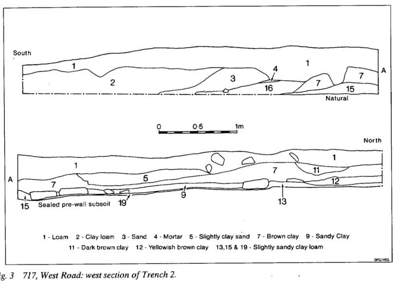
South
Natural
0________ 0-5 1m
N o r th
1 - Loam 2 - Clay loam 3 - Sand 4 - Mortar 5 - Slightly clay sand 7 - Brown clay 9 - Sandy Clay 11 - Dark brown clay 12 - Yellowish brown clay 13,15 & 19 - Slightly sandy clay loam
DFG/VEG
Fig. 3 717, West Road: west section o f Trench 2.
6-row barley and perhaps the Celtic bean were available in the region—if not actually grown here (Van der V een 1985, 197-225). That said, it would be erroneous to champion the limited evidence available as indicating a highly sophisticated agrarian regime in the area in the immediate pre-Roman period (Topping 1989, 146-9). There are two factors which confirm the assessments of contemporary observers, that pastoralism was the leading agrarian activ ity.6 In the first place, many of the indigenous settlements are situated at a suitable elevation to exploit lowland areas for cattle and uplands for sheep (Haselgrove 1984, 12). Then, the osteological evidence is what one might expect from a pastoralist economy, young cattle being the dominant meat source at most sites,
followed by pig and sheep/goat, although at Tynemouth sheep/goat may have been pre ferred (Hodgson 1968; Haselgrove, 1984, 18).
Cultivation certainly took place: but not necessarily any more so than is generally found with traditional transhumant societies.
THE CURTAIN EAST OF NEW CASTLE
E X C A V A T I O N A N D S U R V E Y
The work of Spain et a i (1930, 501, 529, 537-8) conclusively established that the Broad Gauge Wall, built on sandstone flagged-footings, with a superstructure ten pedes Monetales wide (2*96 m = 9 ft 8 in), ran no further east than
Newcastle.7 The length between here and Wallsend, the so-called “Lort Burn Exten sion”, was instead built on footings of pitched clay-fast rubble, with a superstructure built to a narrower gauge, at eight pedes Drusiani (2*44 m = 7 ft 3 in).8 This Narrow Gauge Wall was bonded into the perimeter wall of Wallsend fort, from which it was reasonably deduced that the Lort Burn Extension was a later modification to the original blueprint for the frontier, initiated at the same time it was decided to add the forts to the line (cf. Breeze and Dobson 1987, 78).
Excavation and survey since the 1930’s have broadly confirmed this finding, as well as allowing the Curtain to be recorded in greater detail than formerly considered adequate. For example, when the area around St. Dom inic’s Priory, Stepney Bank, was redeveloped in 1981, the opportunity was taken to trial-trench the site, originally examined by the North of England Excavation Committee in October 1928, both to determine the nature of the remains, and to establish to what extent they would be affected by the development (CAS Site 302; N Z 2585 6445; fig. 1, site 6). The 1928 work had been limited to two trenches. The first, east of the Priory, established that the Wall Ditch was 8*53 m (28 ft) wide and 3*2 m (10 ft 6 in) deep, the berm was about 6*1 m (19 ft 6 in) across, and that the foundations of the Curtain were “about eight foot [2*43 m] wide”; the second, west of the church also located the Wall Ditch, although here the Wall had been “destroyed by the lowering of the surface” (Spain et al. 1930, 496-7).
Of the six trenches opened in 1981, all but two proved negative, a result of the area hav ing been extensively cellared (fig. 4). The two locations where the Wall survived, however, were cleared and examined by hand, and revealed that the footings were laid in a 100 mm (4 in) deep trench, varying in width from 2*30-2*65 m (7 ft 6 in-8 ft 7 in). They con sisted of clay-bound sandstone rubble, “faced” with large, roughly-tapered sandstone blocks, the entire mass being devoid of any evidence for mortar. The superstructure used the same materials, with somewhat more regular facing
stones retaining the clay-fast rubble core: the north face rose directly upon the north face of the footings, but the south face was offset from the rear foundation line by 100 mm, giving an overall width of 2*20 m (7 ft 3 in).
Similar results were obtained when a small trench at the junction of Grenville Terrace and Blagdon Street, first opened by the North of England Excavation Committee in 1928, was re-opened in advance of proposed develop ment in 1978. The earlier work had located the foundation in “fine preservation 8 ft 5 in [2*57 m] wide. The facing stones were again missing.” (Spain et a l 1930, 497). When re examined by Paul Austen exactly fifty years later (CAS Site 70; NZ 2560 6427; fig. 1, site 7), it was possible to confirm the published width of the Wall footings, and verify that it was built of sandstone pieces set in clay.
Further east, however, the digging of a 1*2 m deep gas pipe-line beneath the southern pave ment of the Fossway from No. 174 Fossway to its junction with Baret Road (CEU Site 321; N Z 284 654; fig. 1, site 3), revealed only mod ern build-up overlying a dark grey-brown clayey soil containing a number of dressed, squared sandstone blocks with much rubble and mortar flecks. The Fossway was constructed in the late 1920s, and it was observed then that it would run along the site of the Wall Ditch, the Wall itself lying to the south of the road, in the front gardens of the houses on this side (Spain et al., 495). In view of this, there can be little doubt that the deep stratigraphy and the rubble located by the pipe-trench represent the upper levels of the Wall Ditch fill, with debris from the collapse and/or robbing of the Wall itself.
Likewise, trial-trenching at 260-282 Shields Road, Byker (CAS Site 187; NZ 2720 6486; fig. 1, site 4), the block of land bordered by Potts Street and Robinson Street, also failed to recover any firm evidence for the Wall. That said, two transverse north-south trenches on either side of the plot revealed a 9*1 m (30 ft) wide spread of brown mortary soil and sand stone rubble some 6*1 m (20 ft) south of the Shields Road frontage. Assuming the spread to be continuous across the block, the coinci
Fig. 4 St. Dominic’s Priory, showing the location o f the excavated trenches, with (inset) detailed plans o f the Wall as located in Trenches 2 and 4.
dence between the position of this linear west-east spread and the traditional alignment of the Wall hereabouts does at least allow for the possibility that it might have represented the badly disturbed remains of the Wall foun dation and tumble from the Wall itself.
Trial trenching in 1979 at the east end of Byker Bridge, however, in a plot formerly bounded by 4-36 Shields Road (CEU Site 347; NZ 264 646; fig. 1, site 5), recovered no evi dence whatsoever for the Wall. This spot, the location of an earthwork conventionally iden tified as MC3 (Spain et a l , 496), proved to be the site of quite extensive 19th century dump ing, both of pottery waste and building debris. Not only was there no indication of Roman
structural material, but the absolute failure to locate the pre-19th century soil level or the natural subsoil in trenches dug to a depth of 3 m, confirms that the local topography has been considerably altered since Roman times. It is worth noting in passing that this site was the most westerly excavation by the Unit in the Lort Burn Extension, and it remains true that nothing more has been discovered since the 1930s concerning the alignment of the Lort Burn Extension west of Jubilee Road.
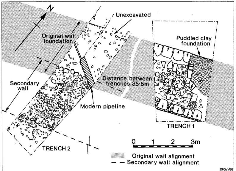
On the other hand, quite surprising results were obtained by Paul Austen in 1978 at the former St. Francis’ Church in Walkerville (CEU Site 150; N Z 2925 6573; fig. 1, site 2; cf. Bidwell and Watson 1989,26) (figs 5 and 6).
Fig. 5 Stotts Road Housing Development, showing the location o f the trenches on either side o f St. Francis Community Centre (formerly church).
To begin with, a trench east o f the church, now used as a Community Centre, revealed that the trench-built Wall footings were of clay-and-cobble and flag-stones, measuring on average 3*10 m (10 ft 9 in) wide (Trench 1). A single course of the original superstructure sur vived on the north face, the clay-and-cobble core being faced with roughly dressed sand stone blocks, with traces of mortar pointing between them.9 At some stage both faces of the Wall had subsided and tilted away from the Wall core, however, fissures up to 250 mm (10 in) wide opening up behind and parallel to the facing stones, a feature which might be compared with the similar evidence for subsi dence found in 1929 some 650 m (720 yds) to the east (Spain et a l , 493-4).
The 3*1 m (10 ft 9 in) wide footings were also located in a second trench excavated immedi ately to the west of the church (Trench 2). A pronounced north-facing camber in the clay- and-cobble foundation suggested that here too the Wall had been subject to subsidence, but here there was clear evidence for re-building, for the primary footings were partially overlain by a second foundation, of sandstone rubble set in clay, faced on both sides with water- rounded boulders, and 3 m (9 ft 9 in) wide. Unfortunately, nothing survived to indicate the width of any superstructure carried by these footings, presumably made so broad to prevent further subsidence.
Unexcavated Puddled clay foundation
/
.&Ai
t&We&ri
„ SecondaryA
a<f i . f ^ l l jS o °«o_o^£M>Sr£° \;. ,) ( wall/ /K ()P c & ^ ° c '& ! °<’ ± & /
o €
/ & 8 SS
\ °*oO °? \ 0 s\ ° /
TRENCH 2 * v ‘ *8°a ;?/ Modern pipeline i Xf/Afv* :^ jN
f t “ t r e n c h? *1
2
3m
Original wall alignment Secondary wall alignment
Fig. 6 Stotts Road Housing Development; sAovW/ig the features revealed in the trenches shown in Fig. 5.
DISCUSSION
The Unit’s work on the Curtain east of New castle, therefore, while small in scale, provided important information concerning the charac ter, form and alignment of the Lort Burn Extension. To begin with, it demonstrated that clay might have been commonly used in its construction, despite the often stated belief that the Narrow Gauge Wall was mortar- bonded throughout (Daniels 1978a, 16). Such a possibility has since been confirmed by the more recent excavations at Buddie Street, at Willowford, and in the vicinity of MC39, where mortar-fast core only occurs with later, probably Severan, re-builds.10 It does seem likely, therefore, that a clay-core was normal
for the Narrow Gauge Wall, mortar only being used to point the interstices between the facing stones, although further sections need to be cut across it at a variety of locations before any categoric statement can be made on this mat ter.
More puzzling was the discovery at St. Fran cis’ Church of what are to all intents and pur poses Broad Gauge footings. A s Bidwell and Watson (1989, 26) have observed, this raises the possibility—one might now say probabil ity—that the Lort Bum Extension was begun before the decision was made to narrow the gauge of the Curtain. In fact detailed analysis of the available evidence reveals a slightly more complex situation. West of Newcastle Broad Gauge footings are only continuous
between Newcastle and the river North Tyne. Beyond the North Tyne to Walltown Crags they exist only in interrupted lengths, although they are continuous once again from that point to the river Irthing. In the intervening sectors, both a Hybrid and standard Narrow Gauge footings have been reported, the Hybrid at 2*74 m (9 ft 9 in) wide, often laid directly over the natural rock surface.
Now, there is no direct evidence for when construction of the Broad Gauge Wall began, although it has been argued on historical and logistical grounds that work must have com menced before 122 (Bennett 1990, 489-98). The Narrow Gauge Wall, however, can be directly associated with the governorship of Platorius Nepos, for it is found over-riding the Broad Gauge wing-walls of MC37 and MC38, all completed during his term of duty on the evidence of their building dedications (RIB 1634, 1637). Yet it is found butted against the defences at Chesters, Housesteads, and Great Chesters; forts which were erected over the demolished remains of the Broad Wall Cur tain.11 These are thought to have been added during N epos’ commission, for they are rea sonably considered to have been built at the same time as the other primary forts on Hadrian’s Wall, one of which, that at Benwell, has produced an inscription relating to his term of office12: unfortunately the precise nature of the Wall Curtain here and its rela tionship to the fort perimeter wall is unknown, as is also the situation at Rudchester and Hal- ton Chesters.13 On the other hand, there is clear evidence that the Narrow Gauge Wall is of one build with the fort perimeters at both
Carrawburgh (Birley 1935b, 95-8) and
Wallsend (Spain et al., 488). The conclusion is inescapable; there was a clear hiatus in the building of the Curtain, during which work was suspended to allow construction of the primary forts, and after which the decision had been made to narrow the Wall gauge. Moreover, the absence of wing-walls at any of these primary sites, comparable to those found on the turrets and milecastles, and on the stone-built primary forts on the Antonine Wall, might even imply that they were intended to be free-standing.
Whatever the length of that hiatus, the Nar row Gauge standard was kept by N epos’ immediate successors. For example, it was used when the fort at Carrawburgh was added to the frontier, an episode which can be dated to c.130 (RIB 1550). It was also used in the building of the Birdoswald salient during the last few years o f . Hadrian’s reign (Simpson 1913, 344; Allason-Jones et al. 1984, 228-35; Welsby 1985, 76). In which case, the fact that Narrow Gauge Wall is bonded with the porta principalis sinistra at Wallsend fort allows the conjecture that this fort was also an addition to the primary scheme, as, indeed, has been argued on other grounds (Swinbank and Spaul 1951, 234)—perhaps, like Carrawburgh, during the governorship of Sextus Julius Severus? Thus, the existence of Broad Gauge founda tions at St. Francis Church could mean that while the Lort Burn Extension was an addition to the original scheme, it was resolved to build this length before the fort decision was made, but that in the event it was not completed until some time later, by which time it had also been decided to build the fort at Wallsend.
THE CURTAIN WEST OF NEWCASTLE
EXCAVATION A N D SURVEY
Between Newcastle and Rudchester, the Cen tral Excavation Unit was responsible for exca vations and survey on the line of the Curtain at three locations. The most easterly was in 1983 at the junction of Clayton Street and Westgate Road (CEU Site 399: NZ 2450 6400). At this place, when the existing north-south mains services were being repaired, a 4*27 m (14 ft) spread of sandstone rubble in a light yellowish clay was revealed, beginning some 4-57 m (15 ft) to the south of the Westgate Road frontage. This spread is coincident with the assumed alignment of Hadrian’s Wall in the vicinity, and can be explained by the repeated excavation and redeposition of the Wall foot ings and collapsed superstructure during the original laying and subsequent maintenance of the existing services.
The second site was the excavation at 717 West Road, already referred to in connection with the pre-Wall ard-marks identified there. At this point the 3 m (9 ft 9 in) wide footings for the Curtain itself were located at a depth of 400 mm) beneath the modern ground level (figs 2 and 3). They filled a cut 3*2 m wide and 100 mm deep into the earlier plough-soii, ana consisted of slabs of local sandstone, packed with a sandy brown clay. Loamy clay spreads on either side of the footings overlay the foun dation trench and the pre-Wall soil, similar to spreads noted elsewhere, for example adjacent to TlOa (Bennett 1983, 30) and at Rudchester Burn (C. Daniels pers comm).
Comparable evidence for the width and sub stance of the Curtain Wall was recovered in the excavations at Throckley (Bennett 1983, 30-32). The exact dimensions of the Curtain could not be recovered, as the north face had not survived later stone-robbing, but it was at least 2*75 m (8 ft 9 in) wide, thus probably Broad Gauge. The foundations were built in a 90 mm (3 in) deep foundation trench, packed with clean clay and stone chippings, indicating that stone-working had been carried out on the site. The footings were of the expected irregular sandstone slabs, and supported a first course of dressed sandstone blocks, with the second course offset on this. Mortar was used to bed and face-point the facing stones, but the core, of undressed sandstone rubble, was clay- fast throughout.
DISCUSSION
The alignment of the Wall west of central Newcastle, by contrast with the Lort Burn Extension, is now fairly secure. The discovery of the Westgate Road Milecastle (for which see below), evidently a long-axis Milecastle built to Broad Gauge standard, confirmed the long-held premise that the Wall Curtain originally ran along a line marked by the south side of the modern Westgate Road, and that the structure itself had most likely been pushed and spread to the north over the berm to consolidate the Wall Ditch to create the forerunner of today’s Westgate Road. It also
served to strengthen the possibility that the length of walling located by F. G. Simpson out side the Mining Institute in 1952 is indeed the south face of Hadrian’s Wall, and that this was built to Broad Gauge (Simpson 1976, 176-8). Even so, it is still unclear what the original eastern terminus of the Curtain might have been.
More important was the confirmation at all the locations examined that the core of the Broad Gauge Wall was bound with compacted clay, mortar being restricted to bedding the facing stones. This particular building style was first recognised in 1949, when consolidation of Brunton Bank Turret, T26b, revealed the adja cent Broad Gauge Curtain on the west side to be clay-bonded to its full surviving height of 1*83 m (6 in) (Richmond 1950, 43^1; 1966, 14-17, passim). A s it was then believed that clay-fast core was the exception rather than the rule, it was later suggested that such lengths denoted work by new legionary recruits (Birley 1960, 52-60; Simpson 1976, 20). In a recent review, however, it was been shown that clay was indeed widely used in the superstructure of the Broad Gauge Wall, at, for example, Denton Burn, Denton Bank, Walbottle Dene, Throckley, Heddon-on-the- Wall and Brunton, as well as in certain of the interval structures, as at TlOa, T18b and T19b, and in the rear and side walls of MC27 (B en nett 1983, 44). To this list other examples can now be added, as at West Denton, North Lodge, Longbyre, and Willowford,14 and it might be noted in passing that in no recent excavation has true Broad Wall been found with a mortared core.
That said, there is still an understandable reluctance to accept that the Broad Gauge Wall might have been clay-fast (Hill and D o b son 1992, 28, 50). But it remains true that mor- tar-fast Broad Gauge Wall has only been reliably attested beneath the 1751 Military Road at Great Hill, where in 1927 road engi neers had to resort to blasting to remove the foundations (Brewis 1927, 115). However, there are valid reasons for disputing the exca vator’s identification of a “concrete” matrix for the core at this place. In the first place, it is dif
ficult to conceive how the curtain could (or would) have ever been reduced to mere foun dations if it was bound by such a tenacious medium that it required the use of dynamite to remove it; secondly, this length lies immedi ately adjacent to a section of Broad Wall which is known to have been clay-bonded (Richmond 1957, 60); and thirdly, it remains unique, despite the considerable lengths of Broad Wall which have since been uncovered. It could be objected that the mortar-core here is the result of a later re-build (cf. RIB 1389, possibly from this area and dated to 158), but this seems most unlikely, as all the known re builds of the Curtain are to a narrower gauge. Therefore, unless the 1927 Great Hill length represents an unique section of mortared Broad Gauge Wall, it must be assumed that the excavators5 mistook a compacted clay-core for the “concrete” they describe, a simple error given the tenacity of the local boulder clay when compressed by traffic, especially when baked by the exposed sun, as this evi dently was, given that the road-works took place in the summer.
Then there is the material evidence for spreads of a loamy-clay soil noted on either side of the Curtain at 717 West Road and TlOa. A t the time of excavation they were identified as construction debris associated with the building of a clay-bonded Curtain Wall or even the debris formed after the col lapse of the structure (Bennett 1983, 44-5). However, the more recent work by Paul Bid- well at West Denton, which resulted in the dis covery of a portion of “plaster55 facing that evidently derived from the south face of the curtain (Bidwell and Watson 1996, 23-6) does allow the possibility that they may be the severely degraded remnants of an eroded clay- and-mortar render originally applied to the face of the Wall.
A n obvious questions arises from this dis cussion, namely why was it originally decided to build the Stone Wall ten pedes Monetales thick, with a clay-fast core and only limited mortar pointing, instead of building a nar rower, mortar-bonded, curtain throughout, as with the Raetian Wall, or with many of the
later clausurae of North Africa. The conven tional explanation, set forth most lucidly by Ian Richmond, is that the Broad Wall was clay-fast because it was quicker and easier to build than one bonded with mortar, and the seemingly excessive width was needed to coun teract any lateral subsidence: when the wide spread use of mortar became more feasible and common, then the Wall was completed to a narrower gauge (Richmond 1966, 14-17). It has been demonstrated above, however, that the Narrow Gauge Wall was also quite prob ably clay-fast, and therefore this explanation is no longer as convincing as when first promul gated. In fact a more obvious alternative explanation is to hand, namely that the Broad Gauge Wall is to all effects and purposes little more than a skeuomorph of the traditional box rampart. These were used in those locations where there was insufficient clay and/or turf to make revetments for the more usual glacis type rampart, and generally take the form of a timber-laced double revetment retaining a core of earth and rubble, or just rubble (Jones 1975, 18). Where insufficient timber was avail able, it was usual to construct the revetments of rough-coursed dry-stone masonry, as can be seen at the complex of forts incorporated in the Republican siege works at Renieblas (Jones 1975, 10-12), and those of first century
a.d. date at Masada. They were also used for
the defences of certain Trajanic forts and fortlets, for example, Gelligaer and Haltwhis- tle Burn in Britain, and Bretcu, Drajna and possibly Hoghiz in Dacia (Lander 1984, 35-7, 43), and they appear in Hadrianic contexts in Germany, as at Hesselbach and the Saalburg (Johnson 1983, 69).
Clay-fast structures would be subject to water-penetration, however. Hence the use of mortar for pointing and bedding the facing stones in the more permanent works, such as Hadrian’s Wall. Also the use of a water-proof render, as is noted by classical authors as a means of protecting masonry defensive works from erosion (cf. Thuc. 3.20.3; also, albeit rhetorically, Aris. O r. 83). Both whitewash and mortar are used even now on the exterior of older domestic buildings in the rural north of
England, to prevent water-penetration of poorly-bonded masonry walls. The masonry- bound clay core of the Broad Gauge Wall would be equally prone to such water-penetra tion, with subsequent freezing in the winter proving a real threat to the very substance of the curtain, although we do not necessarily have to envisage the existence of a white washed Curtain throughout the isthmus (Pace Johnson 1989a, 43).
A s it is, box-ramparts of this type are usually found with widths of around ten Roman Feet or so, a width apparently recommended by at least one Roman military surveyor when describing what would appear to be this very type of defence (Jones, 1975, 74; Veg. 3.8). The reason was evidently to allow them to carry a parapet walk, in case it was ever needed to provide a defensive role. In this sense, the Broad Gauge Wall is little more than a modification of existing methods of cas- trametation, the stretching-out of a fort perimeter wall, as it were, studded with towers and tower-gates at appropriate intervals, in which a box-rampart was built to existing stan dards and methods.
Why, then, was it decided to complete the curtain for much o f its length to a narrower gauge? Given that the core of the Narrow Gauge Wall also seems to have been clay-fast, it cannot have been for structural reasons. Nor can the decision to change the width be justi fied solely in terms of any saving in time and/or labour, as the narrower curtain still needed the same number of correctly dressed facing stones, and it is the preparation of these that was most time and labour intensive: as has been shown elsewhere, reducing the thickness of the curtain would only result in a 26% sav ing on time and labour (Bennett 1990, 605-8). A possible reason might be a change in the tactical function of the curtain, for if the greater width of the Broad Gauge Wall was to provide a broad parapet walk, in order to allow the curtain to be used, either by design or in extremis in a defensive role, then the nar rowing of the curtain, and, consequently, the parapet walk, could imply a change in its per ceived tactical role, or even in the way it was
finished off at the top (Hill and Dobson 1992, 45-6).
THE INTERVAL STRUCTURES
EXCAVATION AND SURVEY
As is well known, the precise location of many interval structures in the Wallsend-Rudchester sector is unknown. The excavation of the Throckley West Turret, TlOa (CEU Site 188; N Z 160 668; fig. 1, site 12), provided a welcome opportunity not only to examine such a struc ture within the city’s limits and assess what sort of damage such structures were prone too, but also produced a further fixed point in the sequence of interval structures in the region (Bennett 1983, 32^10). The turret itself con formed to the expected dimensions of 20 pedes
Monetales (5-92 m = 19 ft 5 in) square, with side
walls 920 mm (3 ft) wide: as with the Curtain, while mortar had been used to point the inter stices on the wall faces, all three side walls were found to be clay-fast. The entrance lay at the east end of the south wall, but there was no trace of any internal “platform”, a feature fre quently found in other turrets.
As we have noted above, however, negative evidence is as valuable as positive in eliminat ing potential sites, and two salvage projects undertaken by the Central Excavation Unit come into this category. The first was at Throckley Bank Top in September, 1983 (CEU 322; N Z 14906685; fig. 1, site 13), the assumed position of MC11, Here, a telephone cable cut along the south side of the Hexham Road failed to reveal any evidence whatsoever for Roman occupation or construction, the spreads of stonework located at the time clearly deriving from the cottages that occu pied the site until c.1975. This was the third time the structure has been unsuccessfully sought, the first occasion being in 1928, when the traditional site to the west of Bank Top was shown to be a colliery tip, and the second being in 1959, a little to the east, when no evi dence for Roman features was forthcoming in any form (Spain 1930, 534; Birley 1961, 96).
Then, in 1980, a watching-brief took place at Town Farm, Heddon on the Wall, the mea sured position of MC12 (CEU Site 63; N Z 1350 6690; fig. 1, site 14). This had been unsuccessfully sought in 1928 and 1929: “It has apparently been entirely obliterated” (Spain et al. 1930, 537). The 1980 work confirmed that the top-soil levels peeled directly off the underlying limestone bedrock, suggesting the surface here has been lowered in recent years, although the Milecastle could, of course, still survive at another position.
DISCUSSION
Returning to the long-standing problem con cerning the location of the interval structures in the W allsend-Rudchester sector, TlOa is one of only three interval structures which can now be exactly located with any degree of reli ability east of MC13, from which point to the Irthing the sites of most of the interval struc tures are tolerably well known. As has been noted elsewhere, the evidence for the positions of many of the others is both “old and unsatis factory” (Harbottle et al. 1988, 157). In fact, assuming the milecastles to start with a nomi nal MCI at “Old Walker Farmhouse” (Bruce 1863, 42-3), then out of the first thirteen assumed Milecastles between Wallsend and Rudchester the precise locations of only three (the Westgate Road Milecastle, MC9 and MC10) are known for certain, a recovery rate of 23.08%. This compares exactly with the sit uation west of MC54, where only six out of the 26 probable sites have been located.
In the schedule of interval structures as first devised, it was assumed that there were eight milecastles at regular intervals between Wallsend and the first proven example, that at Chapel House, MC9.15 This assumption, and the accepted positions of the unlocated exam ples, was first seriously challenged after the discovery of the Westgate Road Milecastle, Newcastle, the position of which did not con form to the accepted schedule (Harbottle, et al. 1988, 157; Johnson 1989, 325). Even so, although the traditional locations of the “unknown” milecastles between Wallsend and
Rudchester, as at other sectors on the frontier line, might reasonably be questioned, any dis crepancies recorded between the alleged and the actual positions of any of the interval struc tures need not necessarily invalidate the proposition that the milecastles were originally spaced from Wallsend to Bowness with a cer tain degree of regularity. Indeed, it can be argued that there is every justification for the continued use of the traditional enumeration system and its assumed total of 80 milecastles.
To begin with, while nothing has been found to substantiate early antiquarian observations of the presumed milecastles on the Lort Burn Extension, allowing for some dissenting opin ions about their assumed locations,16 there seems little reason to doubt that such struc tures were not originally provided. In the first instance, there is the fact that these interval structures retained some purpose in the later phases of the frontier system, for they were provided on the Birdoswald salient, a length of curtain probably contemporary with the Lort Burn Extension. Then a series of fortlets directly comparable to the milecastles were provided along the Antonine Wall (Hanson and Maxwell 1983, 93-6), which shows that there was still a place for these structures in other, and later, frontier systems. This should be construed as a mark of their continued use fulness in whatever role they performed, as is borne out by the even later decision to re-build in stone all the Turf Wall milecastles from MC54 onwards, when the Intermediate Wall was constructed c.a.d. 160 (Bennett,
forthcom-
ing)-That accepted, as the curtain east of New castle was built over fairly level ground, and is contiguous with the fort at Wallsend, it is a reasonable proposition that the interval struc tures were provided at equidistant intervals along it. This may well have been the case, as MacLauchlan’s survey (1858, 8) recorded the remains of what he considered to be milecas tles in this sector, spaced at intervals of between 1,308-1,408 m (4,290 ft-4,620 ft). If his interpretation of these remains is correct, as is highly likely, for he was a trained sur veyor and evidently an observant and reliable
fieldworker (Charlton and Day 1984, 27-32), then there would have been three milecastles between the fort at Wallsend and the Westgate Road Milecastle. A s it is, the only apparent evidence for any interval structure in the W allsend-Newcastle sector might be “Fowler’s Turret”, a structure which seems to have been an interval structure imbedded in the Curtain and which was recorded by the eponymous Canon in 1877 in the vicinity of The Grange (Birley 1935a, 27). On the basis of the map published by Horsley (1732, 158) it has since been proposed that this was a blocked mile castle gateway (Birley 1960, 46). On the other hand, despite some discrepancies in its reported position, it could well be that this structure was the same as the “turret” destroyed in the vicinity in 1936 (Simpson 1975,105-6,115; Wright 1985,213).
In fact, in its own way the discovery of the Westgate Road Milecastle provides valuable support for the hypothesis that such fortlets were regularly spaced from Newcastle west wards. Granted that it is a standard Broad Gauge Wall-type milecastle, it can reasonably be assumed that others existed between it and the next identified, that at Chapel House, MC9 on Collingwood’s system. This is some 4-89 km (13,414 ft) distant, only 260*9 m (856 ft) less than the expected five Roman miles, at 7*39 km (24,270*8 ft), making an average sepa ration of 1*48 km (4,854 ft) in each “Wall- M ile” between them, a shortfall of 52*12 m (171ft) per “Wall-Mile”. That figure is well- within the known range of discrepancies found elsewhere in the linear spacing of the milecas tles over level terrain (Bennett 1990, tab A l, fig. 8). Thus, if we identify—for the sake of argument— the Westgate Road Milecastle as MC4 according to Collingwood’s system, for it would indeed be the fourth from a nominal MCI at Old Walker Farmhouse, then, given the known variations in the spacing of the “Wall-Miles”, the Westgate Road milecastle in no way disproves the contention that the Broad Wall Milecastles hereabouts were located at regular intervals approximating to a Roman mile. In which case, making all due allowance for both a “Short” “Wall-Mile” and
local topography, it is possible to suggest loca tions for the three “missing” milecastles. Thus “MC5” might be expected on the summit of Elswick Hill, at about 1,300 m (4,270 ft) from MC4, the Westgate Road Milecastle, while “MC6” was perhaps located on the summit of Benwell Hill, 1,500 m (4920 ft) or so distant, the site later occupied by Benwell fort. If so, “MC7” would presumably be at some point on the west-facing slope of D enton D ene, perhaps mid-way between Benwell Hill and Denton Bank, and “MC8” might be found at its tradi tional position at Denton Lodge (Spain et al., 1930, 531).
Even if this hypothesis concerning the Mile castle spacing is found acceptable, there still remain considerable problems concerning the location of the interval turrets. A s is well known, from at least D enton Bank west there were normally two turrets between each of the milecastles, usually regularly spaced from each other to trisect the relevant “Wall M ile” into intervals of 540 yds. (493*78 m = 1,620 ft) (Collingwood 1930 as refined by Birley 1961, 71-7). But if we accept MacLauchlan’s posi tions for the first three milecastles then “Fowler’s Turret” would be almost half-way between Wallsend and MacLauchlan’s (1858, 8) first milecastle. This might suggest that there was a single turret at the mid-way point of each “Wall M ile” along the Lort Burn Extension, rather than the two found else where. Now, it just so happens that there is evidence for a similar spacing in the first seven miles west of Newcastle. The first identified turret in this sector, “Shafto’s turret”, at the junction of Two Ball Lonnen and the West Road, T6b on the Collingwood schedule, is some 610 m (2,000 ft) from the newly-calcu lated position for “MC6”, thus approximately half-way between this and the inferred posi tion of MC7.
It can rightly be objected that not so much credence should be placed on the correct iden tification or even the exact location of these structures. Yet the possibility of such a spacing being originally intended is supported by the position of West Denton Turret, T7b on the traditional schedule. A s is well known, this
structure is 652 m (2,140 ft) east of the position of MC8 instead of the expected 490-7 m (1,610 ft), an inaccuracy of 25% in the assumed spacing, much greater, in fact, than any other recorded milecastle-turret interval on the fron tier. Yet, there is sufficient evidence to indi
cate that Roman linear surveying was
remarkably accurate, especially along
Hadrian’s Wall and the spacing recorded between the known structures is most unlikely to result from simply bad surveying. If, how ever, the milecastles in this area are indeed spaced at intervals of slightly less than one Roman Mile, at about 1*42 km (4,600 ft), as is implied by the position of the Westgate Road Milecastle, then West Denton Turret is only some 49 m (160 ft) from the mid-way point between MC8 and the computed site of MC7. True, until further sites are located, “the true state of affairs will remain obscure” (Daniels 1978a, 72). Even so, the possibility does exist that as originally designed, there was only one turret per “Wall-Mile” for the first eight miles of the frontier.
THE FORTS
EXCAVATION A N D SURVEY
While no work was carried out by the Central Excavation Unit on the interior of any of the four forts in the W allsend-Rudchester sector, a watching brief did take place just south-west of that at Wallsend in 1977, under the direc
tion of Jeff Coppen (CEU Site 128;
NZ 2995 6595; fig. 1, site 1). The 1*5 ha (3-5 acre) site, formerly bounded by Buddie Street, Gerald Street, Benton Way and Camp Road, was thought to be where earlier antiquarian reports had placed the fort’s vicus (Spain et al. 1930, 492-3; Birley 1961, 159-60; Daniels, 1978a, 58-9). As the available plot of land sloped away to the south and the west, the southern part of the proposed development was built up on concrete rafts, and the north ern part terraced. This northern area was trial- trenched to a maximum depth of 1-83 m (6 ft), and it was established that it had been built up
in comparatively recent times, spreads of blue clay and shale, perhaps deriving from the for mer Wallsend Colliery, sealing the original topsoil at depths which varied from 1 5 m (4 ft 11 in) to 1-83 m (6 ft). The only structural features identified were all of m odem date, and probably associated with the colliery, although sherds of Roman and medieval pot tery did occur as stray finds throughout the area. It would seem that the colliery workings had either eradicated or obliterated any remains o f Roman settlement that might for merly have existed in the vicinity, especially given the comparatively shallow depth of the stratigraphy at the nearby fort site.
THE VALLUM
EXCAVATION A N D SURVEY
There is no evidence for the Vallum ever hav ing continued beyond Newcastle, nor has it been traced in limited excavations east of Elswick, and it is now generally accepted that it originally started in the vicinity of Redheugh Bridge and ran up Elswick Row to the bottom of Elswick Bank, the. place where it is first reli ably recorded (Spain et a l 1930, 519). Even so, while it is generally accepted that the Vallum runs on a parallel alignment to the Curtain from Elswick Row west, excepting for the diversions around the forts, its precise course remains uncertain. This is partly because of the extensive quarrying of the land south of the Wall in this sector. For example, when the Central Excavation Unit trial-trenched the block of land bounded by Elswick Row, Back Elswick Street and Westgate Road in October 1978 (CEU Site 330; NZ 236 641; fig. 1, site 8), the two trenches revealed nothing other than 19th century waste deposits to a depth of at least 3 m (9 ft 9 in), suggesting they represen ted quarry-fill.
Similar results were obtained when the Unit examined a site further to west, on the east side of the junction of Westgate Road and
Grainger Park Road (CEU Site 300;
the point where the Vallum is first recorded by the antiquarians, and its alignment from here westwards, at generally about 63 m (70 yds) south of the West Road, would seem to be indicated by subsidence cracks in the streets and houses in this area (Spain et a i 1930, 516-9). The only archaeological feature dis covered, however, was a rock quarry filled with assorted 19th century debris.
The excavations at Throckley, on the other hand, revealed a good cross-section through the Vallum (Bennett 1983, 40-3). A single trench indicated that it was originally 4*8 m (15 ft 6 in) wide at the top, with steeply-angled sides dug to a slope of 80 degrees, and a flat bottom, 2*9 m (9 ft 6 in) wide and 2*1 m (6 ft 11 in) deep.
DISCUSSION
There are a number of problems concerning the Vallum, a feature peculiar to the British frontier, but here we limit ourselves to those aspects relating to its purpose and probable date. To begin with, it might be observed that although the construction of the Vallum was contemporary with the decision to add the pri mary forts to the line of the Curtain, detailed analysis suggests that while in some places its alignment anticipates the construction of the forts, elsewhere it was evidently dug after the fort-sites had at least been decided upon (B en nett 1990, 436; Bowden and Blood 1991, 30). On the other hand, the Vallum underlies the fort at Carrawburgh, generally thought to have been constructed, with the Narrow Gauge Wall, during the governorship of Sextus Julius Severus, thus c.130. Then we have noted that the Vallum does not continue east of Newcas tle, which might suggest it was not considered necessary when the Lort Burn Extension and the fort at Wallsend were completed.
While there is no clear explanation for the Vallum’s purpose, there is little doubt con cerning its function. Despite the special plead ing recently advanced, it is far too complex and significant an earthwork to have served simply to form a “boundary-marker rather than an obstacle, an unmistakable indication
of forbidden territory, creating a 120 yard stretch which no-one should pass over unob served.’* (Dobson 1986, 18; cf. Stukely 1776, 59; Richmond, 1950, 52; Birley, 1961, 124) A s Williams (1983, 33) has observed, it would make a formidable and effective “tank trap”, and it would have made an impassable obsta cle to all travelling across the line of the fron tier except at the authorised points opposite the forts.
Likewise there can be no doubt that the Val lum had served its purpose when the fort at Carrawburgh was built, for there was no attempt to reconstruct it on a new alignment. Then, as we have seen, it does not exist east of Newcastle, where the Narrow Gauge Curtain is of one build with Wallsend fort, both being late Hadrianic additions to the original frontier scheme. South of the fort at Birdoswald, by comparison, the Vallum seems to have been deliberately filled before c.140 (Swinbank and Gillam 1952, 60-61) and a similar date might be attributed to the obliteration of the Vallum at Benwell, although this has been attributed to the early third century Birley 1947, 52-67; Swinbank 1955, 142-162). Finally, a series of excavations across the Vallum itself have revealed conclusive evidence that it was delib erately filled before any significant amount of silt had accumulated, as if “not less than five and not more than fifteen years” had elapsed between its cutting and its eradication.17
Herein lies a possible explanation for the purpose of the Vallum. As we have seen, there was a hiatus between the decision to build the forts on the frontier, and the much later com pletion of the Wall and its interval structures to Narrow Gauge. Indeed, there is conclusive evidence that in several sectors, only the Wall foundations had been laid at the time of the fort decision, and that when the time came to build the Curtain, it took an entirely different line, as if the original foundations were now no longer visible or too eroded to be of any use. Then there is the evidence that the Vallum was evidently only open for a short time, and that work had already started on its elimination as an obstacle to passage north and south before the reign of Hadrian was out—indeed, it was